Bridge Statistics for Hermitage, Pennsylvania (PA)
Condition, Traffic, Stress, Structural Evaluation, Project Costs
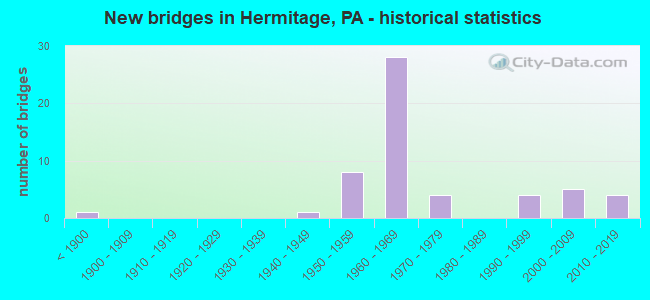
- New bridges - historical statistics
- 1Before 1900
- 11940-1949
- 81950-1959
- 281960-1969
- 41970-1979
- 41990-1999
- 52000-2009
- 42010-2019
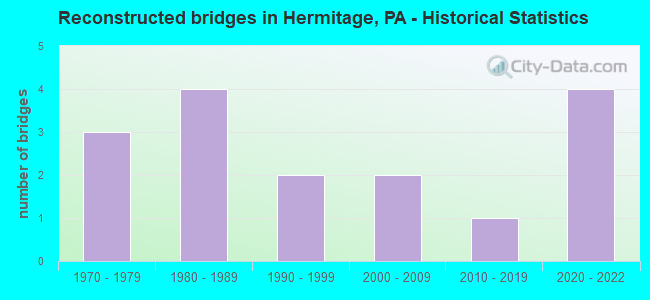
- Reconstructed bridges - Historical Statistics
- 31970-1979
- 41980-1989
- 21990-1999
- 22000-2009
- 12010-2019
- 42020-2022
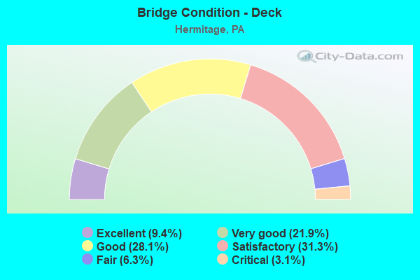
- Bridge Condition - Deck
- 9.4%Excellent
- 21.9%Very good
- 28.1%Good
- 31.3%Satisfactory
- 6.3%Fair
- 3.1%Critical
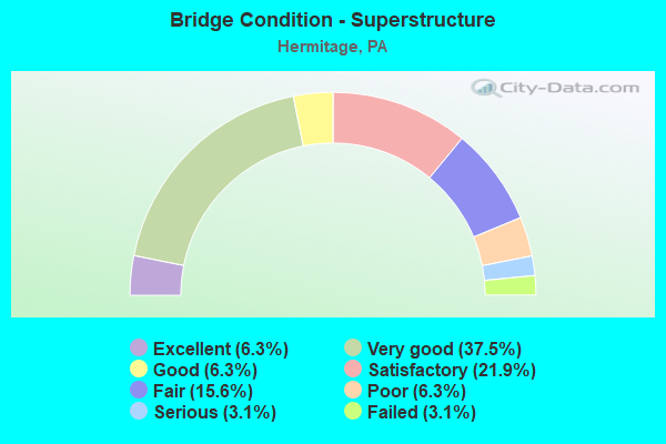
- Bridge Condition - Superstructure
- 6.3%Excellent
- 37.5%Very good
- 6.3%Good
- 21.9%Satisfactory
- 15.6%Fair
- 6.3%Poor
- 3.1%Serious
- 3.1%Failed
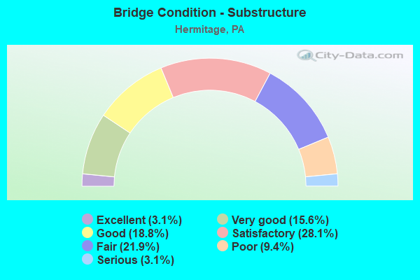
- Bridge Condition - Substructure
- 3.1%Excellent
- 15.6%Very good
- 18.8%Good
- 28.1%Satisfactory
- 21.9%Fair
- 9.4%Poor
- 3.1%Serious
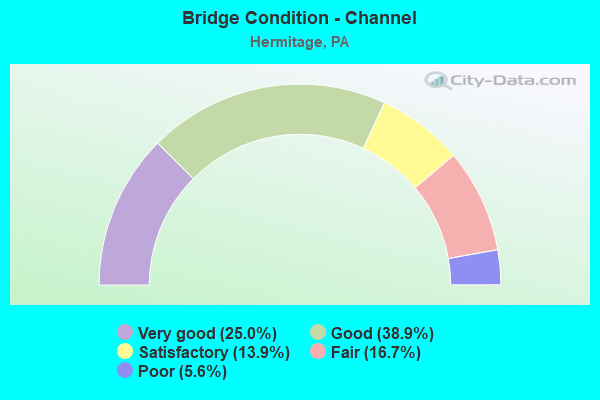
- Bridge Condition - Channel
- 25.0%Very good
- 38.9%Good
- 13.9%Satisfactory
- 16.7%Fair
- 5.6%Poor
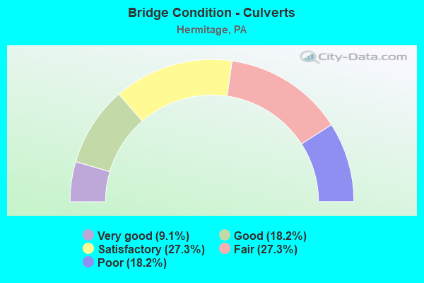
- Bridge Condition - Culverts
- 9.1%Very good
- 18.2%Good
- 27.3%Satisfactory
- 27.3%Fair
- 18.2%Poor
Find on map >> Show street view
Structure Number: 48866, Location: CITY OF HERMITAGE (Lat: 41.254092, Lng: -80.504817), Route carried "on" structure: State highway 718, Year Built: 2014, Status: Open, Structure Length: 2.50m (8.20ft), Average Daily Traffic: 2,575 (year 2021), Truck Traffic: 5%, Average Future Daily Traffic: 3,924 (year 2032), Design Load: HL 93, Features Intersected: BIG RUN
Minimum Vertical Clearance: 30+ m (98+ ft), Kilometerpoint: 10.889, Lanes on structure: 2, Owner: State Highway Agency, Approaching Roadway Width: 9.1m (29.9ft), Material/Design: Prestressed concrete, Design/Construction: Box Beam or Girders - Single/Spread, Number Of Spans In Main Unit: 1, Length of Maximum Span: 24.1m (79.1ft), Curb or Sidewalk Widths: Left: 0.1m (0.3ft), Right: 0.1m (0.3ft), Curb-To-Curb Width: 8.9m (29.2ft), Out-to-Out Width: 9.9m (32.5ft)
Condition: Deck: Excellent, Superstructure: Excellent, Substructure: Excellent, Channel: Very good, Operating Rating: 46.3 metric tons, Method Used To Determine Operating Rating: Assigned ratings based on Load and Resistance Factor Design (LRFD) reported by rating factor (RF) using HL93 loadings, Inventory Rating: 32.7 metric tons, Method Used To Determine Inventory Rating: Assigned ratings based on Load and Resistance Factor Design (LRFD) reported by rating factor (RF) using HL93 loadings, Structural Evaluation: Superior to present desirable criteria, Deck Geometry: Meets minimum limits, Waterway Adequacy: Equal to present desirable criteria, Approach Roadway Alignment: Somewhat better than minimum adequacy, Designated Inspection Frequency: Every 24 months, Inspection Date: October 2020, Deck Structure Type: Concrete Cast-file-Place, Wearing Surface/Protective System: Wearing Surface: Bituminous, Membrane: Preformed Fabric, Deck Protection: Epoxy Coated Reinforcing
Find on map >> Show street view
Structure Number: 53935, Location: LACKAWANNOCK TOWNSHIP (Lat: 41.192158, Lng: -80.389278), Route carried "on" structure: State highway 318, Year Built: 2017, Status: Open, Structure Length: 2.26m (7.41ft), Average Daily Traffic: 2,377 (year 2021), Truck Traffic: 16%, Average Future Daily Traffic: 2,348 (year 2037), Design Load: HL 93, Features Intersected: Little Neshannock Creek
Minimum Vertical Clearance: 30+ m (98+ ft), Kilometerpoint: 11.148, Lanes on structure: 2, Owner: State Highway Agency, Maintenance Responsibility: Private, Approaching Roadway Width: 7.3m (24.0ft), Skew: 1 degrees, Material/Design: Prestressed concrete, Design/Construction: Box Beam or Girders - Single/Spread, Length of Maximum Span: 21.3m (69.9ft), Curb-To-Curb Width: 9.8m (32.2ft), Out-to-Out Width: 10.4m (34.1ft)
Condition: Deck: Very good, Superstructure: Very good, Substructure: Very good, Channel: Fair, Operating Rating: 62.9 metric tons, Method Used To Determine Operating Rating: Assigned ratings based on Load and Resistance Factor Design (LRFD) reported by rating factor (RF) using HL93 loadings, Inventory Rating: 48.3 metric tons, Method Used To Determine Inventory Rating: Assigned ratings based on Load and Resistance Factor Design (LRFD) reported by rating factor (RF) using HL93 loadings, Structural Evaluation: Equal to present desirable criteria, Deck Geometry: Meets minimum limits, Waterway Adequacy: Equal to present desirable criteria, Approach Roadway Alignment: Equal to present desirable criteria, Designated Inspection Frequency: Every 24 months, Inspection Date: September 2020, Deck Structure Type: Concrete Cast-file-Place, Wearing Surface/Protective System: Wearing Surface: Integral Concrete, Deck Protection: Epoxy Coated Reinforcing
Find on map >> Show street view
Structure Number: 55049, Location: 0.7 MI. S. CH186 (Lat: 41.267667, Lng: -80.519114), Route carried "on" structure: County highway T0182, Year Built: 1964, Year Reconstructed: 1991, Status: Posted for load, Structure Length: 1.19m (3.90ft), Average Daily Traffic: 324 (year 2015), Truck Traffic: 7%, Average Future Daily Traffic: 450 (year 2038), Features Intersected: BIG RUN, Facility Carried by Structure: OHIO T-182
Minimum Vertical Clearance: 30+ m (98+ ft), Kilometerpoint: 0.000, Lanes on structure: 2, Owner: State Agenciy, Approaching Roadway Width: 7.9m (25.9ft), Skew: 3 degrees, Material/Design: Steel, Design/Construction: Stringer/Multi-beam, Number Of Spans In Main Unit: 1, Length of Maximum Span: 10.1m (33.1ft), Curb-To-Curb Width: 7.9m (25.9ft), Out-to-Out Width: 8.4m (27.6ft)
Condition: Deck: Satisfactory, Superstructure: Serious, Substructure: Serious, Channel: Good, Operating Rating: 6.4 metric tons, Method Used To Determine Operating Rating: Field evaluation and documented engineering judgment, Inventory Rating: 4.5 metric tons, Method Used To Determine Inventory Rating: Field evaluation and documented engineering judgment, Structural Evaluation: High priority of replacement, Deck Geometry: Somewhat better than minimum adequacy, Waterway Adequacy: Better than present minimum criteria, Approach Roadway Alignment: Equal to present desirable criteria, Bridge Posting: Required (Relationship of Operating Rating to Maximum Legal Load: > 39.9% below), Length Of Structure Improvement: 1.20m (3.94ft), Designated Inspection Frequency: Every 24 months, Other Special Inspection Frequency: Every 12 months, Inspection Date: April 2021, Other Special Inspection Date: April 2021, Wearing Surface/Protective System: Wearing Surface: Bituminous
Find on map >> Show street view
Structure Number: 56667, Location: LACKAWANNOCK TWP (Lat: 41.186633, Lng: -80.331042), Route carried "on" structure: City street T397, Year Built: 1963, Status: Open, Structure Length: 0.79m (2.59ft), Average Daily Traffic: 212 (year 2019), Truck Traffic: 4%, Average Future Daily Traffic: 300 (year 2039), Features Intersected: OVER HARTHEGIG RUN, Facility Carried by Structure: BRIDGE 2450, T-397
Minimum Vertical Clearance: 30+ m (98+ ft), Kilometerpoint: 0.000, Lanes on structure: 2, Owner: Town or Township Highway Agency, Approaching Roadway Width: 4.3m (14.1ft), Skew: 4 degrees, Material/Design: Concrete, Design/Construction: Culvert, Number Of Spans In Main Unit: 1, Length of Maximum Span: 7.9m (25.9ft), Curb-To-Curb Width: 6.2m (20.3ft), Out-to-Out Width: 11.0m (36.1ft)
Condition: Channel: Very good, Culverts: Poor, Operating Rating: 78.9 metric tons, Method Used To Determine Operating Rating: Field evaluation and documented engineering judgment, Inventory Rating: 47.2 metric tons, Method Used To Determine Inventory Rating: Field evaluation and documented engineering judgment, Structural Evaluation: Meets minimum limits, Deck Geometry: Meets minimum limits, Waterway Adequacy: Equal to present desirable criteria, Approach Roadway Alignment: Equal to present desirable criteria, Designated Inspection Frequency: Every 24 months, Inspection Date: November 2019, Wearing Surface/Protective System: Wearing Surface: Bituminous
Find on map >> Show street view
Structure Number: 25692, Location: SHENANGO TOWNSHIP (Lat: 41.184589, Lng: -80.443267), Route carried "under" structure: Interstate 80, Year Built: 1966, Structure Length: 0. m, Average Daily Traffic: 15,835 (year 2021), Truck Traffic: 32%, Features Intersected: OVER SR 80,EB/WB, Facility Carried by Structure: SR 60,NB BEAVER
Minimum Vertical Clearance: 5.28m (17.32ft), Kilometerpoint: 6.465, Lanes on structure: 3, Lanes under structure: 6, Material/Design: Prestressed concrete, Design/Construction: Stringer/Multi-beam, Length of Maximum Span: 27.4m (89.9ft)
Find on map >> Show street view
Structure Number: 25692, Location: SHENANGO TOWNSHIP (Lat: 41.184589, Lng: -80.443267), Route carried "under" structure: Interstate 80, Year Built: 1966, Structure Length: 0. m, Average Daily Traffic: 15,595 (year 2021), Truck Traffic: 37%, Features Intersected: OVER SR 80,EB/WB, Facility Carried by Structure: SR 60,NB BEAVER
Minimum Vertical Clearance: 5.28m (17.32ft), Kilometerpoint: 6.452, Lanes on structure: 3, Lanes under structure: 6, Material/Design: Prestressed concrete, Design/Construction: Stringer/Multi-beam, Length of Maximum Span: 27.4m (89.9ft)
Find on map >> Show street view
Structure Number: 25695, Location: SHENANGO TOWNSHIP (Lat: 41.184589, Lng: -80.443644), Route carried "under" structure: Interstate 80, Year Built: 1966, Structure Length: 0. m, Average Daily Traffic: 15,835 (year 2021), Truck Traffic: 32%, Features Intersected: OVER SR 80,EB/WB, Facility Carried by Structure: SR 60,SB BEAVER
Minimum Vertical Clearance: 5.03m (16.50ft), Kilometerpoint: 6.465, Lanes on structure: 3, Lanes under structure: 6, Material/Design: Prestressed concrete, Design/Construction: Stringer/Multi-beam, Length of Maximum Span: 27.4m (89.9ft)
Find on map >> Show street view
Structure Number: 25695, Location: SHENANGO TOWNSHIP (Lat: 41.184589, Lng: -80.443644), Route carried "under" structure: Interstate 80, Year Built: 1966, Structure Length: 0. m, Average Daily Traffic: 15,595 (year 2021), Truck Traffic: 37%, Features Intersected: OVER SR 80,EB/WB, Facility Carried by Structure: SR 60,SB BEAVER
Minimum Vertical Clearance: 5.51m (18.08ft), Kilometerpoint: 6.452, Lanes on structure: 3, Lanes under structure: 6, Material/Design: Prestressed concrete, Design/Construction: Stringer/Multi-beam, Length of Maximum Span: 27.4m (89.9ft)
Find on map >> Show street view
Structure Number: 25697, Location: SHENANGO TOWNSHIP (Lat: 41.187314, Lng: -80.455858), Route carried "under" structure: State highway 18, Year Built: 1966, Structure Length: 0. m, Average Daily Traffic: 17,349 (year 2020), Truck Traffic: 5%, Features Intersected: OVER SR 18,S HERMITAGE, Facility Carried by Structure: SR 60,NB/SB BEAVER
Minimum Vertical Clearance: 4.88m (16.01ft), Kilometerpoint: 11.344, Lanes on structure: 3, Lanes under structure: 2, Material/Design: Prestressed concrete, Design/Construction: Box Beam or Girders - Single/Spread, Length of Maximum Span: 14.9m (48.9ft)
Find on map >> Show street view
Structure Number: 25776, Location: SHENANGO TOWNSHIP (Lat: 41.183361, Lng: -80.422431), Route carried "under" structure: State highway 318, Year Built: 1966, Structure Length: 0. m, Average Daily Traffic: 2,872 (year 2021), Truck Traffic: 17%, Features Intersected: OVER SR 318,W MDDSX-MER, Facility Carried by Structure: SR 80,EB
Minimum Vertical Clearance: 4.42m (14.50ft), Kilometerpoint: 8.489, Lanes on structure: 2, Lanes under structure: 2, Material/Design: Prestressed concrete, Design/Construction: Box Beam or Girders - Single/Spread, Length of Maximum Span: 21.6m (70.9ft)
Find on map >> Show street view
Structure Number: 25777, Location: SHENANGO TOWNSHIP (Lat: 41.183528, Lng: -80.421681), Route carried "under" structure: State highway 318, Year Built: 1966, Structure Length: 0. m, Average Daily Traffic: 2,872 (year 2021), Truck Traffic: 17%, Features Intersected: OVER SR 318,W MDDSX-MER, Facility Carried by Structure: SR 80,WB
Minimum Vertical Clearance: 4.34m (14.24ft), Kilometerpoint: 8.489, Lanes on structure: 2, Lanes under structure: 2, Material/Design: Prestressed concrete, Design/Construction: Box Beam or Girders - Single/Spread, Length of Maximum Span: 21.6m (70.9ft)
Find on map >> Show street view
Structure Number: 2578, Location: LACKAWANNOCK TOWNSHIP (Lat: 41.185200, Lng: -80.364097), Route carried "under" structure: City street T300, Year Built: 1965, Structure Length: 0. m, Average Daily Traffic: 49 (year 2002), Features Intersected: OVER T300,GREENFIELD RD, Facility Carried by Structure: SR 80,EB
Minimum Vertical Clearance: 4.45m (14.60ft), Kilometerpoint: 0.000, Lanes on structure: 2, Lanes under structure: 2, Material/Design: Prestressed concrete, Design/Construction: Box Beam or Girders - Single/Spread, Length of Maximum Span: 10.7m (35.1ft)
Find on map >> Show street view
Structure Number: 25781, Location: LACKAWANNOCK TOWNSHIP (Lat: 41.185506, Lng: -80.364131), Route carried "under" structure: City street T300, Year Built: 1965, Structure Length: 0. m, Average Daily Traffic: 49 (year 2002), Features Intersected: OVER T300,GREENFIELD RD, Facility Carried by Structure: SR 80,WB
Minimum Vertical Clearance: 4.55m (14.93ft), Kilometerpoint: 0.000, Lanes on structure: 2, Lanes under structure: 2, Material/Design: Prestressed concrete, Design/Construction: Box Beam or Girders - Single/Spread, Length of Maximum Span: 10.7m (35.1ft)
Find on map >> Show street view
Structure Number: 25992, Location: SHENANGO TOWNSHIP (Lat: 41.182989, Lng: -80.394214), Route carried "under" structure: Interstate 80, Year Built: 1965, Structure Length: 0. m, Average Daily Traffic: 15,835 (year 2021), Truck Traffic: 32%, Features Intersected: OVER SR 80,EB/WB, Facility Carried by Structure: SR 3011,BETHEL RD
Minimum Vertical Clearance: 5.03m (16.50ft), Kilometerpoint: 10.475, Lanes on structure: 2, Lanes under structure: 4, Material/Design: Prestressed concrete, Design/Construction: Box Beam or Girders - Single/Spread, Length of Maximum Span: 17.1m (56.1ft)
Find on map >> Show street view
Structure Number: 25992, Location: SHENANGO TOWNSHIP (Lat: 41.182989, Lng: -80.394214), Route carried "under" structure: Interstate 80, Year Built: 1965, Structure Length: 0. m, Average Daily Traffic: 15,595 (year 2021), Truck Traffic: 37%, Features Intersected: OVER SR 80,EB/WB, Facility Carried by Structure: SR 3011,BETHEL RD
Minimum Vertical Clearance: 5.17m (16.96ft), Kilometerpoint: 10.406, Lanes on structure: 2, Lanes under structure: 4, Material/Design: Prestressed concrete, Design/Construction: Box Beam or Girders - Single/Spread, Length of Maximum Span: 17.1m (56.1ft)
Find on map >> Show street view
Structure Number: 42875, Location: CITY OF HERMITAGE (Lat: 41.257783, Lng: -80.456903), Route carried "under" structure: City street , Year Built: 2006, Structure Length: 0. m, Features Intersected: PINE HOLLOW RUN, Facility Carried by Structure: SR 518,WALNUT ST
Minimum Vertical Clearance: 5.82m (19.09ft), Kilometerpoint: 0.000, Lanes on structure: 2, Lanes under structure: 2, Material/Design: Prestressed concrete continuous, Design/Construction: Stringer/Multi-beam, Length of Maximum Span: 39.9m (130.9ft)