Bridge Statistics for Hoover, Alabama (AL)
Condition, Traffic, Stress, Structural Evaluation, Project Costs
- National Bridge Inventory (NBI) Statistics
- 97Number of bridges
- 2,034ft / 620mTotal length
- $298,088,000Total costs
- 3,091,276Total average daily traffic
- 361,645Total average daily truck traffic
- National Bridge Inventory (NBI) Registered Bridges for Hoover
- No street view available for this location
- New bridges - historical statistics
- 11920-1929
- 81960-1969
- 491970-1979
- 201980-1989
- 41990-1999
- 112000-2009
- 22010-2019
- 22020-2022
- Reconstructed bridges - Historical Statistics
- 41980-1989
- 21990-1999
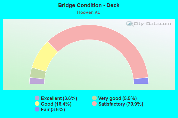
- Bridge Condition - Deck
- 3.6%Excellent
- 5.5%Very good
- 16.4%Good
- 70.9%Satisfactory
- 3.6%Fair
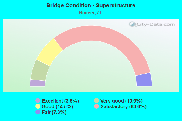
- Bridge Condition - Superstructure
- 3.6%Excellent
- 10.9%Very good
- 14.5%Good
- 63.6%Satisfactory
- 7.3%Fair
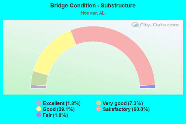
- Bridge Condition - Substructure
- 1.8%Excellent
- 7.3%Very good
- 29.1%Good
- 60.0%Satisfactory
- 1.8%Fair
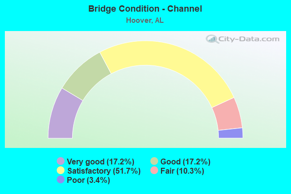
- Bridge Condition - Channel
- 17.2%Very good
- 17.2%Good
- 51.7%Satisfactory
- 10.3%Fair
- 3.4%Poor
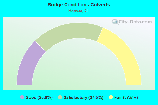
- Bridge Condition - Culverts
- 25.0%Good
- 37.5%Satisfactory
- 37.5%Fair
Find on map >> Show street view
Structure Number: 198, Location: 0.1 MI S JCT US 31 (Lat: 33.126539, Lng: -86.753753), Route carried "on" structure: County highway 211, Year Built: 1922, Status: Open, Structure Length: 2.68m (8.79ft), Average Daily Traffic: 50 (year 2021), Average Future Daily Traffic: 70 (year 2041), Features Intersected: RAILROAD
Minimum Vertical Clearance: 30+ m (98+ ft), Kilometerpoint: 0.010, Lanes on structure: 2, Owner: County Highway Agency, Approaching Roadway Width: 5.8m (19.0ft), Material/Design: Concrete, Design/Construction: Tee Beam, Number Of Spans In Main Unit: 1, Number Of Approach Spans: 2, Length of Maximum Span: 12.8m (42.0ft), Curb-To-Curb Width: 5.5m (18.0ft), Out-to-Out Width: 6.7m (22.0ft)
Condition: Deck: Satisfactory, Superstructure: Fair, Substructure: Satisfactory, Operating Rating: 55.4 metric tons, Method Used To Determine Operating Rating: Load Factor (LF), Inventory Rating: 33.2 metric tons, Method Used To Determine Inventory Rating: Load Factor (LF), Structural Evaluation: Somewhat better than minimum adequacy, Deck Geometry: Meets minimum limits, Underclear: Somewhat better than minimum adequacy, Approach Roadway Alignment: Better than present minimum criteria, Length Of Structure Improvement: 3.60m (11.81ft), Designated Inspection Frequency: Every 24 months, Inspection Date: Febuary 2021, Bridge Improvement Cost: $543,000, Roadway Improvement Cost: $54,000, Total Project Cost: $597,000 ( Estimate for 2022), Deck Structure Type: Concrete Cast-file-Place
Find on map >> Show street view
Structure Number: 214, Location: SEC. 2 T11N R20E (Lat: 31.960100, Lng: -86.017700), Route carried "on" structure: County highway , Year Built: 1992, Status: Open, Structure Length: 1.80m (5.91ft), Average Daily Traffic: 500 (year 2008), Truck Traffic: 10%, Average Future Daily Traffic: 600 (year 2035), Design Load: HS 20, Features Intersected: BEAMON CREEK, Facility Carried by Structure: COUNTY ROAD 7707
Minimum Vertical Clearance: 30+ m (98+ ft), Kilometerpoint: 0.000, Lanes on structure: 2, Owner: County Highway Agency, Approaching Roadway Width: 9.1m (29.9ft), Material/Design: Concrete, Design/Construction: Culvert, Number Of Spans In Main Unit: 4, Length of Maximum Span: 4.3m (14.1ft), Curb-To-Curb Width: 11.7m (38.4ft), Out-to-Out Width: 12.2m (40.0ft)
Condition: Channel: Fair, Culverts: Satisfactory, Operating Rating: 44.2 metric tons, Method Used To Determine Operating Rating: Load Factor (LF), Inventory Rating: 26.5 metric tons, Method Used To Determine Inventory Rating: Load Factor (LF), Structural Evaluation: Equal to present minimum criteria, Deck Geometry: Better than present minimum criteria, Waterway Adequacy: Somewhat better than minimum adequacy, Approach Roadway Alignment: Equal to present desirable criteria, Length Of Structure Improvement: 2.51m (8.23ft), Designated Inspection Frequency: Every 24 months, Inspection Date: November 2020, Bridge Improvement Cost: $580,000, Roadway Improvement Cost: $58,000, Total Project Cost: $638,000 ( Estimate for 2022)
Find on map >> Show street view
Structure Number: 6694, Location: SOUTHLAND DR * PATTON CK (Lat: 33.400000, Lng: -86.800000), Route carried "on" structure: City street , Year Built: 1968, Status: Posted for load, Structure Length: 3.11m (10.20ft), Average Daily Traffic: 7,899 (year 2020), Truck Traffic: 1%, Average Future Daily Traffic: 9,086 (year 2040), Design Load: H 15, Features Intersected: PATTON CREEK, Facility Carried by Structure: SOUTHLAND DR
Minimum Vertical Clearance: 30+ m (98+ ft), Kilometerpoint: 0.100, Lanes on structure: 2, Owner: City or Municipal Highway Agency, Approaching Roadway Width: 6.4m (21.0ft), Skew: 1 degrees, Material/Design: Concrete, Design/Construction: Channel Beam, Number Of Spans In Main Unit: 3, Length of Maximum Span: 10.4m (34.1ft), Curb-To-Curb Width: 8.9m (29.2ft), Out-to-Out Width: 9.4m (30.8ft)
Condition: Deck: Satisfactory, Superstructure: Satisfactory, Substructure: Satisfactory, Channel: Satisfactory, Operating Rating: 37.6 metric tons, Method Used To Determine Operating Rating: Load Factor (LF), Inventory Rating: 21.4 metric tons, Method Used To Determine Inventory Rating: Load Factor (LF), Structural Evaluation: Somewhat better than minimum adequacy, Deck Geometry: High priority of replacement, Waterway Adequacy: Equal to present minimum criteria, Approach Roadway Alignment: Equal to present minimum criteria, Bridge Posting: Required (Relationship of Operating Rating to Maximum Legal Load: 0.1 - 9.9% below), Length Of Structure Improvement: 3.96m (12.99ft), Designated Inspection Frequency: Every 24 months, Other Special Inspection Frequency: Every 12 months, Inspection Date: August 2020, Other Special Inspection Date: August 2021, Bridge Improvement Cost: $815,000, Roadway Improvement Cost: $82,000, Total Project Cost: $897,000 ( Estimate for 2022), Deck Structure Type: Concrete Precast Panels, Wearing Surface/Protective System: Wearing Surface: Bituminous
Find on map >> Show street view
Structure Number: 7179, Location: 0.8 MI S AL 150 (HOOVER) (Lat: 33.338656, Lng: -86.874794), Route carried "on" structure: County highway 405, Year Built: 1960, Status: Open, Structure Length: 2.49m (8.17ft), Average Daily Traffic: 13,170 (year 2020), Truck Traffic: 5%, Average Future Daily Traffic: 18,395 (year 2040), Design Load: H 15, Features Intersected: CSX RAILROAD, Facility Carried by Structure: SO.SHADES CREST R
Minimum Vertical Clearance: 30+ m (98+ ft), Kilometerpoint: 0.010, Lanes on structure: 2, Owner: County Highway Agency, Approaching Roadway Width: 6.9m (22.6ft), Material/Design: Steel, Design/Construction: Stringer/Multi-beam, Number Of Spans In Main Unit: 1, Length of Maximum Span: 23.9m (78.4ft), Curb or Sidewalk Widths: Left: 0.5m (1.6ft), Right: 0.5m (1.6ft), Curb-To-Curb Width: 8.4m (27.6ft), Out-to-Out Width: 10.1m (33.1ft)
Condition: Deck: Fair, Superstructure: Satisfactory, Substructure: Satisfactory, Operating Rating: 59.9 metric tons, Method Used To Determine Operating Rating: Load Factor (LF), Inventory Rating: 35.4 metric tons, Method Used To Determine Inventory Rating: Load Factor (LF), Structural Evaluation: Equal to present minimum criteria, Deck Geometry: High priority of replacement, Underclear: Meets minimum limits, Approach Roadway Alignment: Better than present minimum criteria, Length Of Structure Improvement: 3.37m (11.06ft), Designated Inspection Frequency: Every 24 months, Inspection Date: September 2020, Bridge Improvement Cost: $763,000, Roadway Improvement Cost: $76,000, Total Project Cost: $839,000 ( Estimate for 2022), Deck Structure Type: Concrete Cast-file-Place
Find on map >> Show street view
Structure Number: 8425, Location: CREEKVIEW DR * PATTON CK (Lat: 33.400000, Lng: -86.800000), Route carried "on" structure: City street , Year Built: 1964, Status: Posted for load, Structure Length: 2.07m (6.79ft), Average Daily Traffic: 3,796 (year 2020), Truck Traffic: 1%, Average Future Daily Traffic: 4,036 (year 2040), Design Load: H 15, Features Intersected: PATTON CREEK, Facility Carried by Structure: CREEKVIEW DR
Minimum Vertical Clearance: 30+ m (98+ ft), Kilometerpoint: 0.010, Lanes on structure: 2, Owner: City or Municipal Highway Agency, Approaching Roadway Width: 6.1m (20.0ft), Material/Design: Concrete, Design/Construction: Channel Beam, Number Of Spans In Main Unit: 2, Length of Maximum Span: 10.4m (34.1ft), Curb-To-Curb Width: 7.9m (25.9ft), Out-to-Out Width: 8.8m (28.9ft)
Condition: Deck: Good, Superstructure: Fair, Substructure: Good, Channel: Good, Operating Rating: 34.2 metric tons, Method Used To Determine Operating Rating: Load Factor (LF), Inventory Rating: 17.9 metric tons, Method Used To Determine Inventory Rating: Load Factor (LF), Structural Evaluation: Meets minimum limits, Deck Geometry: High priority of corrective action, Waterway Adequacy: Equal to present desirable criteria, Approach Roadway Alignment: Equal to present desirable criteria, Bridge Posting: Required (Relationship of Operating Rating to Maximum Legal Load: 20.0 - 29.9% below), Length Of Structure Improvement: 2.84m (9.32ft), Designated Inspection Frequency: Every 24 months, Other Special Inspection Frequency: Every 12 months, Inspection Date: August 2020, Other Special Inspection Date: August 2021, Bridge Improvement Cost: $565,000, Roadway Improvement Cost: $57,000, Total Project Cost: $622,000 ( Estimate for 2022), Deck Structure Type: Concrete Precast Panels, Wearing Surface/Protective System: Wearing Surface: Bituminous
Find on map >> Show street view
Structure Number: 8426, Location: KESTWICK DR * PATTON CK (Lat: 33.400000, Lng: -86.800000), Route carried "on" structure: City street , Year Built: 1966, Status: Open, Structure Length: 3.11m (10.20ft), Average Daily Traffic: 1,564 (year 2020), Truck Traffic: 1%, Average Future Daily Traffic: 2,785 (year 2040), Design Load: H 15, Features Intersected: PATTON CREEK, Facility Carried by Structure: KESTWICK DR
Minimum Vertical Clearance: 30+ m (98+ ft), Kilometerpoint: 0.010, Lanes on structure: 2, Owner: City or Municipal Highway Agency, Approaching Roadway Width: 6.4m (21.0ft), Material/Design: Concrete, Design/Construction: Channel Beam, Number Of Spans In Main Unit: 3, Length of Maximum Span: 10.4m (34.1ft), Curb-To-Curb Width: 8.0m (26.2ft), Out-to-Out Width: 8.9m (29.2ft)
Condition: Deck: Good, Superstructure: Fair, Substructure: Good, Channel: Good, Operating Rating: 53.2 metric tons, Method Used To Determine Operating Rating: Load Factor (LF), Inventory Rating: 31.8 metric tons, Method Used To Determine Inventory Rating: Load Factor (LF), Structural Evaluation: Somewhat better than minimum adequacy, Deck Geometry: Meets minimum limits, Waterway Adequacy: Equal to present desirable criteria, Approach Roadway Alignment: Equal to present minimum criteria, Length Of Structure Improvement: 3.96m (12.99ft), Designated Inspection Frequency: Every 24 months, Inspection Date: August 2020, Bridge Improvement Cost: $788,000, Roadway Improvement Cost: $79,000, Total Project Cost: $867,000 ( Estimate for 2022), Deck Structure Type: Concrete Precast Panels, Wearing Surface/Protective System: Wearing Surface: Bituminous
Find on map >> Show street view
Structure Number: 8429, Location: DEODARA DR * STARLAKE DR (Lat: 33.400000, Lng: -86.800000), Route carried "on" structure: City street , Year Built: 1964, Status: Open, Structure Length: 0.76m (2.49ft), Average Daily Traffic: 3,723 (year 2020), Truck Traffic: 1%, Average Future Daily Traffic: 3,881 (year 2040), Design Load: H 15, Features Intersected: LAKE DRAINAGE, Facility Carried by Structure: DEODARA DR
Minimum Vertical Clearance: 30+ m (98+ ft), Kilometerpoint: 0.010, Lanes on structure: 2, Owner: City or Municipal Highway Agency, Approaching Roadway Width: 7.3m (24.0ft), Material/Design: Concrete, Design/Construction: Culvert, Number Of Spans In Main Unit: 4, Length of Maximum Span: 1.8m (5.9ft)
Condition: Channel: Very good, Culverts: Fair, Operating Rating: 63.0 metric tons, Method Used To Determine Operating Rating: Load Factor (LF), Inventory Rating: 37.7 metric tons, Method Used To Determine Inventory Rating: Load Factor (LF), Structural Evaluation: Somewhat better than minimum adequacy, Waterway Adequacy: Equal to present minimum criteria, Approach Roadway Alignment: Equal to present minimum criteria, Length Of Structure Improvement: 1.41m (4.63ft), Designated Inspection Frequency: Every 24 months, Inspection Date: August 2020, Bridge Improvement Cost: $229,000, Roadway Improvement Cost: $23,000, Total Project Cost: $252,000 ( Estimate for 2022)
Find on map >> Show street view
Structure Number: 8472, Location: 1 MILE SOUTH OF HOOVER (Lat: 33.376500, Lng: -86.827700), Route carried "on" structure: County highway 502, Year Built: 1964, Status: Posted for load, Structure Length: 0.91m (2.99ft), Average Daily Traffic: 2,530 (year 2020), Truck Traffic: 5%, Average Future Daily Traffic: 3,250 (year 2040), Design Load: H 20, Features Intersected: HURRICANE BRANCH, Facility Carried by Structure: AL SEIER ROAD
Minimum Vertical Clearance: 30+ m (98+ ft), Kilometerpoint: 0.010, Lanes on structure: 2, Owner: City or Municipal Highway Agency, Approaching Roadway Width: 6.8m (22.3ft), Material/Design: Concrete, Design/Construction: Channel Beam, Number Of Spans In Main Unit: 2, Length of Maximum Span: 3.8m (12.5ft), Curb or Sidewalk Widths: Left: 0.2m (0.7ft), Right: 0.2m (0.7ft), Curb-To-Curb Width: 7.2m (23.6ft), Out-to-Out Width: 7.6m (24.9ft)
Condition: Deck: Satisfactory, Superstructure: Satisfactory, Substructure: Fair, Channel: Satisfactory, Operating Rating: 27.1 metric tons, Method Used To Determine Operating Rating: Load Factor (LF), Inventory Rating: 16.2 metric tons, Method Used To Determine Inventory Rating: Load Factor (LF), Structural Evaluation: Meets minimum limits, Deck Geometry: High priority of replacement, Waterway Adequacy: Equal to present minimum criteria, Approach Roadway Alignment: Better than present minimum criteria, Bridge Posting: Required (Relationship of Operating Rating to Maximum Legal Load: 30.0 - 39.9% below), Length Of Structure Improvement: 1.59m (5.22ft), Designated Inspection Frequency: Every 24 months, Other Special Inspection Frequency: Every 12 months, Inspection Date: August 2020, Other Special Inspection Date: August 2021, Bridge Improvement Cost: $272,000, Roadway Improvement Cost: $27,000, Total Project Cost: $299,000 ( Estimate for 2022), Deck Structure Type: Concrete Precast Panels, Wearing Surface/Protective System: Wearing Surface: Bituminous
Find on map >> Show street view
Structure Number: 8936, Location: 1.75 MI E LORNA RD (Lat: 33.393200, Lng: -86.771817), Route carried "on" structure: County highway 527, Year Built: 1965, Status: Open, Structure Length: 4.88m (16.01ft), Average Daily Traffic: 5,776 (year 2021), Truck Traffic: 5%, Average Future Daily Traffic: 8,000 (year 2041), Design Load: H 20, Features Intersected: LITTLE SHADES CREEK, Facility Carried by Structure: OLD ROCKY RIDGE RD
Minimum Vertical Clearance: 30+ m (98+ ft), Kilometerpoint: 0.010, Lanes on structure: 2, Owner: County Highway Agency, Approaching Roadway Width: 7.3m (24.0ft), Skew: 1 degrees, Material/Design: Concrete, Design/Construction: Channel Beam, Number Of Spans In Main Unit: 5, Length of Maximum Span: 9.8m (32.2ft), Curb-To-Curb Width: 7.3m (24.0ft), Out-to-Out Width: 7.9m (25.9ft)
Condition: Deck: Satisfactory, Superstructure: Satisfactory, Substructure: Good, Channel: Satisfactory, Operating Rating: 39.9 metric tons, Method Used To Determine Operating Rating: Load Factor (LF), Inventory Rating: 23.9 metric tons, Method Used To Determine Inventory Rating: Load Factor (LF), Structural Evaluation: Somewhat better than minimum adequacy, Deck Geometry: High priority of replacement, Waterway Adequacy: Equal to present minimum criteria, Approach Roadway Alignment: Better than present minimum criteria, Length Of Structure Improvement: 5.89m (19.32ft), Designated Inspection Frequency: Every 24 months, Inspection Date: June 2021, Bridge Improvement Cost: $1,009,000, Roadway Improvement Cost: $101,000, Total Project Cost: $1,110,000 ( Estimate for 2022), Deck Structure Type: Concrete Precast Panels
Find on map >> Show street view
Structure Number: 10601, Location: LOCH HAVEN RD * LOCHHAVEN (Lat: 33.383333, Lng: -86.783333), Route carried "on" structure: City street , Year Built: 1971, Status: Open, Structure Length: 3.14m (10.30ft), Average Daily Traffic: 1,251 (year 2020), Truck Traffic: 4%, Average Future Daily Traffic: 1,242 (year 2040), Design Load: H 15, Features Intersected: BRANCH, Facility Carried by Structure: LOCH HAVEN RD
Minimum Vertical Clearance: 30+ m (98+ ft), Kilometerpoint: 0.010, Lanes on structure: 2, Owner: City or Municipal Highway Agency, Approaching Roadway Width: 9.1m (29.9ft), Material/Design: Concrete, Design/Construction: Channel Beam, Number Of Spans In Main Unit: 3, Length of Maximum Span: 10.4m (34.1ft), Curb-To-Curb Width: 8.9m (29.2ft), Out-to-Out Width: 9.4m (30.8ft)
Condition: Deck: Good, Superstructure: Good, Substructure: Very good, Channel: Fair, Operating Rating: 39.9 metric tons, Method Used To Determine Operating Rating: Load Factor (LF), Inventory Rating: 23.9 metric tons, Method Used To Determine Inventory Rating: Load Factor (LF), Structural Evaluation: Equal to present minimum criteria, Deck Geometry: Somewhat better than minimum adequacy, Waterway Adequacy: Equal to present desirable criteria, Approach Roadway Alignment: Equal to present desirable criteria, Length Of Structure Improvement: 4.00m (13.12ft), Designated Inspection Frequency: Every 24 months, Inspection Date: August 2020, Bridge Improvement Cost: $849,000, Roadway Improvement Cost: $85,000, Total Project Cost: $934,000 ( Estimate for 2022), Deck Structure Type: Concrete Precast Panels
Find on map >> Show street view
Structure Number: 11743, Location: I 459 * US 31 (Lat: 33.384800, Lng: -86.806300), Route carried "on" structure: Interstate 459, Year Built: 1977, Year Reconstructed: 2002, Status: Open, Structure Length: 8.72m (28.61ft), Average Daily Traffic: 54,815 (year 2020), Truck Traffic: 11%, Average Future Daily Traffic: 69,309 (year 2040), Design Load: HS 20, Features Intersected: AL - 3 (US 31)
Minimum Vertical Clearance: 30+ m (98+ ft), Kilometerpoint: 22.370, Lanes on structure: 3, Lanes under structure: 4, Base Highway Network: Yes, Owner: State Highway Agency, Approaching Roadway Width: 20.6m (67.6ft), Skew: 2 degrees, Material/Design: Steel continuous, Design/Construction: Stringer/Multi-beam, Number Of Spans In Main Unit: 3, Length of Maximum Span: 36.6m (120.1ft), Curb-To-Curb Width: 20.7m (67.9ft), Out-to-Out Width: 21.6m (70.9ft)
Condition: Deck: Satisfactory, Superstructure: Satisfactory, Substructure: Satisfactory, Operating Rating: 68.5 metric tons, Method Used To Determine Operating Rating: Load Factor (LF), Inventory Rating: 41.0 metric tons, Method Used To Determine Inventory Rating: Load Factor (LF), Structural Evaluation: Equal to present minimum criteria, Deck Geometry: Superior to present desirable criteria, Underclear: Equal to present minimum criteria, Approach Roadway Alignment: Equal to present desirable criteria, Length Of Structure Improvement: 9.70m (31.82ft), Designated Inspection Frequency: Every 24 months, Inspection Date: November 2020, Bridge Improvement Cost: $4,655,000, Roadway Improvement Cost: $466,000, Total Project Cost: $5,121,000 ( Estimate for 2022), Deck Structure Type: Concrete Cast-file-Place
Find on map >> Show street view
Structure Number: 11744, Location: I459 * US31 (Lat: 33.384200, Lng: -86.806900), Route carried "on" structure: Interstate 459, Year Built: 1977, Status: Open, Structure Length: 8.72m (28.61ft), Average Daily Traffic: 54,815 (year 2020), Truck Traffic: 11%, Average Future Daily Traffic: 69,309 (year 2040), Design Load: HS 20, Features Intersected: AL - 3 (US 31)
Minimum Vertical Clearance: 30+ m (98+ ft), Kilometerpoint: 22.370, Lanes on structure: 5, Lanes under structure: 5, Base Highway Network: Yes, Owner: State Highway Agency, Approaching Roadway Width: 24.4m (80.1ft), Skew: 2 degrees, Material/Design: Steel continuous, Design/Construction: Stringer/Multi-beam, Number Of Spans In Main Unit: 3, Length of Maximum Span: 36.6m (120.1ft), Curb-To-Curb Width: 24.2m (79.4ft), Out-to-Out Width: 25.1m (82.3ft)
Condition: Deck: Satisfactory, Superstructure: Satisfactory, Substructure: Satisfactory, Operating Rating: 72.5 metric tons, Method Used To Determine Operating Rating: Load Factor (LF), Inventory Rating: 43.4 metric tons, Method Used To Determine Inventory Rating: Load Factor (LF), Structural Evaluation: Equal to present minimum criteria, Deck Geometry: Equal to present minimum criteria, Underclear: Equal to present minimum criteria, Approach Roadway Alignment: Better than present minimum criteria, Length Of Structure Improvement: 9.70m (31.82ft), Designated Inspection Frequency: Every 24 months, Inspection Date: October 2020, Bridge Improvement Cost: $5,453,000, Roadway Improvement Cost: $545,000, Total Project Cost: $5,998,000 ( Estimate for 2022), Deck Structure Type: Concrete Cast-file-Place
Find on map >> Show street view
Structure Number: 11745, Location: LORNA RD * I 459 (Lat: 33.389136, Lng: -86.796339), Route carried "on" structure: City street , Year Built: 1977, Status: Open, Structure Length: 11.06m (36.29ft), Average Daily Traffic: 3,500 (year 2021), Truck Traffic: 1%, Average Future Daily Traffic: 5,500 (year 2041), Design Load: HS 20, Features Intersected: I - 459, Facility Carried by Structure: LORNA RD
Minimum Vertical Clearance: 30+ m (98+ ft), Kilometerpoint: 0.010, Lanes on structure: 5, Lanes under structure: 10, Owner: State Highway Agency, Approaching Roadway Width: 24.4m (80.1ft), Material/Design: Steel continuous, Design/Construction: Stringer/Multi-beam, Number Of Spans In Main Unit: 4, Length of Maximum Span: 30.5m (100.1ft), Curb-To-Curb Width: 24.4m (80.1ft), Out-to-Out Width: 25.1m (82.3ft)
Condition: Deck: Satisfactory, Superstructure: Satisfactory, Substructure: Satisfactory, Operating Rating: 68.2 metric tons, Method Used To Determine Operating Rating: Allowable Stress (AS), Inventory Rating: 40.7 metric tons, Method Used To Determine Inventory Rating: Allowable Stress (AS), Structural Evaluation: Equal to present minimum criteria, Deck Geometry: Superior to present desirable criteria, Underclear: Equal to present minimum criteria, Approach Roadway Alignment: Equal to present desirable criteria, Length Of Structure Improvement: 11.95m (39.21ft), Designated Inspection Frequency: Every 24 months, Inspection Date: March 2021, Bridge Improvement Cost: $6,719,000, Roadway Improvement Cost: $672,000, Total Project Cost: $7,391,000 ( Estimate for 2022), Deck Structure Type: Concrete Cast-file-Place
Find on map >> Show street view
Structure Number: 11746, Location: I 65 * I 459 INTERCHANGE (Lat: 33.393358, Lng: -86.785736), Route carried "on" structure: Interstate 459, Year Built: 1977, Status: Open, Structure Length: 21.58m (70.80ft), Average Daily Traffic: 51,820 (year 2020), Truck Traffic: 10%, Average Future Daily Traffic: 65,522 (year 2040), Design Load: HS 20, Features Intersected: RAMPS C*D
Minimum Vertical Clearance: 7.04m (23.10ft), Kilometerpoint: 24.538, Lanes on structure: 3, Lanes under structure: 2, Base Highway Network: Yes, Owner: State Highway Agency, Approaching Roadway Width: 16.2m (53.1ft), Material/Design: Steel continuous, Design/Construction: Stringer/Multi-beam, Number Of Spans In Main Unit: 7, Length of Maximum Span: 41.5m (136.2ft), Curb-To-Curb Width: 15.9m (52.2ft), Out-to-Out Width: 16.7m (54.8ft)
Condition: Deck: Satisfactory, Superstructure: Satisfactory, Substructure: Satisfactory, Operating Rating: 43.5 metric tons, Method Used To Determine Operating Rating: Load Factor (LF), Inventory Rating: 32.7 metric tons, Method Used To Determine Inventory Rating: Load Factor (LF), Structural Evaluation: Equal to present minimum criteria, Deck Geometry: Somewhat better than minimum adequacy, Underclear: Equal to present minimum criteria, Approach Roadway Alignment: Equal to present desirable criteria, Length Of Structure Improvement: 21.58m (70.80ft), Designated Inspection Frequency: Every 24 months, Critical Feature Inspection Frequency: Every 24 months, Inspection Date: April 2020, Critical Feature Inspection Date: April 2020, Bridge Improvement Cost: $7,990,000, Roadway Improvement Cost: $799,000, Total Project Cost: $8,789,000 ( Estimate for 2022), Deck Structure Type: Concrete Cast-file-Place
Find on map >> Show street view
Structure Number: 11747, Location: I 65 * I 459 INTERCHANGE (Lat: 33.392939, Lng: -86.786092), Route carried "on" structure: Interstate 459, Year Built: 1977, Status: Open, Structure Length: 24.87m (81.59ft), Average Daily Traffic: 51,820 (year 2021), Truck Traffic: 10%, Average Future Daily Traffic: 65,522 (year 2041), Design Load: HS 20, Features Intersected: RAMP D
Minimum Vertical Clearance: 5.92m (19.42ft), Kilometerpoint: 24.473, Lanes on structure: 3, Lanes under structure: 2, Base Highway Network: Yes, Owner: State Highway Agency, Approaching Roadway Width: 16.2m (53.1ft), Material/Design: Steel continuous, Design/Construction: Stringer/Multi-beam, Number Of Spans In Main Unit: 7, Length of Maximum Span: 41.5m (136.2ft), Curb-To-Curb Width: 15.9m (52.2ft), Out-to-Out Width: 16.7m (54.8ft)
Condition: Deck: Satisfactory, Superstructure: Satisfactory, Substructure: Satisfactory, Operating Rating: 65.6 metric tons, Method Used To Determine Operating Rating: Load Factor (LF), Inventory Rating: 39.3 metric tons, Method Used To Determine Inventory Rating: Load Factor (LF), Structural Evaluation: Equal to present minimum criteria, Deck Geometry: Somewhat better than minimum adequacy, Underclear: High priority of corrective action, Approach Roadway Alignment: Equal to present desirable criteria, Length Of Structure Improvement: 24.87m (81.59ft), Designated Inspection Frequency: Every 24 months, Critical Feature Inspection Frequency: Every 24 months, Inspection Date: May 2021, Critical Feature Inspection Date: May 2021, Bridge Improvement Cost: $9,209,000, Roadway Improvement Cost: $921,000, Total Project Cost: $10,130,000 ( Estimate for 2022), Deck Structure Type: Concrete Cast-file-Place
Find on map >> Show street view
Structure Number: 11759, Location: I 459/I 65 INTERCHANGE (Lat: 33.392100, Lng: -86.784700), Route carried "on" structure: Interstate 65, Year Built: 1977, Status: Open, Structure Length: 30.98m (101.64ft), Average Daily Traffic: 56,815 (year 2020), Truck Traffic: 13%, Average Future Daily Traffic: 71,980 (year 2040), Design Load: HS 20, Features Intersected: I 459
Minimum Vertical Clearance: 5.59m (18.34ft), Kilometerpoint: 402.256, Lanes on structure: 3, Lanes under structure: 8, Base Highway Network: Yes, Owner: State Highway Agency, Approaching Roadway Width: 18.9m (62.0ft), Material/Design: Steel continuous, Design/Construction: Stringer/Multi-beam, Number Of Spans In Main Unit: 9, Length of Maximum Span: 40.1m (131.6ft), Curb-To-Curb Width: 15.8m (51.8ft), Out-to-Out Width: 17.6m (57.7ft)
Condition: Deck: Satisfactory, Superstructure: Satisfactory, Substructure: Satisfactory, Operating Rating: 45.2 metric tons, Method Used To Determine Operating Rating: Load Factor (LF), Inventory Rating: 27.0 metric tons, Method Used To Determine Inventory Rating: Load Factor (LF), Structural Evaluation: Equal to present minimum criteria, Deck Geometry: Somewhat better than minimum adequacy, Underclear: High priority of replacement, Approach Roadway Alignment: Equal to present desirable criteria, Length Of Structure Improvement: 30.98m (101.64ft), Designated Inspection Frequency: Every 24 months, Inspection Date: July 2020, Bridge Improvement Cost: $12,107,000, Roadway Improvement Cost: $1,211,000, Total Project Cost: $13,318,000 ( Estimate for 2022), Deck Structure Type: Concrete Cast-file-Place
Find on map >> Show street view
Structure Number: 1176, Location: I 459/I 65 INTERCHANGE (Lat: 33.392653, Lng: -86.784511), Route carried "on" structure: Interstate 65, Year Built: 1977, Status: Open, Structure Length: 32.09m (105.28ft), Average Daily Traffic: 56,815 (year 2020), Truck Traffic: 13%, Average Future Daily Traffic: 71,980 (year 2040), Design Load: HS 20, Features Intersected: I - 459 & RAMPS
Minimum Vertical Clearance: 5.41m (17.75ft), Kilometerpoint: 402.256, Lanes on structure: 3, Lanes under structure: 8, Base Highway Network: Yes, Owner: State Highway Agency, Approaching Roadway Width: 18.9m (62.0ft), Material/Design: Steel continuous, Design/Construction: Stringer/Multi-beam, Number Of Spans In Main Unit: 9, Length of Maximum Span: 40.4m (132.5ft), Curb-To-Curb Width: 15.8m (51.8ft), Out-to-Out Width: 17.6m (57.7ft)
Condition: Deck: Satisfactory, Superstructure: Satisfactory, Substructure: Satisfactory, Operating Rating: 46.2 metric tons, Method Used To Determine Operating Rating: Load Factor (LF), Inventory Rating: 27.7 metric tons, Method Used To Determine Inventory Rating: Load Factor (LF), Structural Evaluation: Equal to present minimum criteria, Deck Geometry: Somewhat better than minimum adequacy, Underclear: High priority of corrective action, Approach Roadway Alignment: Equal to present desirable criteria, Length Of Structure Improvement: 32.09m (105.28ft), Designated Inspection Frequency: Every 24 months, Inspection Date: August 2020, Bridge Improvement Cost: $12,543,000, Roadway Improvement Cost: $1,254,000, Total Project Cost: $13,797,000 ( Estimate for 2022), Deck Structure Type: Concrete Cast-file-Place
Find on map >> Show street view
Structure Number: 11761, Location: I 65 I 459 INTERCHANGE (Lat: 33.393025, Lng: -86.784036), Route carried "on" structure: Ramp Interstate 65, Year Built: 1977, Status: Open, Structure Length: 21.43m (70.31ft), Average Daily Traffic: 11,363 (year 2020), Truck Traffic: 13%, Average Future Daily Traffic: 14,396 (year 2040), Design Load: HS 20, Features Intersected: I 65 I459 AND RAMPS, Facility Carried by Structure: RAMP 61 TO I459 SB
Minimum Vertical Clearance: 30+ m (98+ ft), Kilometerpoint: 401.710, Lanes on structure: 2, Lanes under structure: 14, Owner: State Highway Agency, Approaching Roadway Width: 13.4m (44.0ft), Material/Design: Steel continuous, Design/Construction: Stringer/Multi-beam, Number Of Spans In Main Unit: 6, Length of Maximum Span: 42.4m (139.1ft), Curb-To-Curb Width: 12.0m (39.4ft), Out-to-Out Width: 13.0m (42.7ft)
Condition: Deck: Satisfactory, Superstructure: Satisfactory, Substructure: Satisfactory, Operating Rating: 37.8 metric tons, Method Used To Determine Operating Rating: Load Factor (LF), Inventory Rating: 22.7 metric tons, Method Used To Determine Inventory Rating: Load Factor (LF), Structural Evaluation: Somewhat better than minimum adequacy, Deck Geometry: Superior to present desirable criteria, Underclear: Meets minimum limits, Approach Roadway Alignment: Equal to present minimum criteria, Length Of Structure Improvement: 21.43m (70.31ft), Designated Inspection Frequency: Every 24 months, Inspection Date: August 2020, Bridge Improvement Cost: $6,171,000, Roadway Improvement Cost: $617,000, Total Project Cost: $6,788,000 ( Estimate for 2022), Deck Structure Type: Concrete Cast-file-Place
Find on map >> Show street view
Structure Number: 11762, Location: I 65 I 459 INTERCHANGE (Lat: 33.393489, Lng: -86.783531), Route carried "on" structure: Ramp Interstate 65, Year Built: 1977, Status: Open, Structure Length: 21.85m (71.69ft), Average Daily Traffic: 11,363 (year 2020), Truck Traffic: 13%, Average Future Daily Traffic: 14,396 (year 2040), Design Load: HS 20, Features Intersected: I 65 HOOVER, Facility Carried by Structure: RAMPS MP249.62
Minimum Vertical Clearance: 30+ m (98+ ft), Kilometerpoint: 401.726, Lanes on structure: 2, Lanes under structure: 14, Owner: State Highway Agency, Approaching Roadway Width: 13.4m (44.0ft), Material/Design: Steel continuous, Design/Construction: Stringer/Multi-beam, Number Of Spans In Main Unit: 6, Length of Maximum Span: 42.4m (139.1ft), Curb-To-Curb Width: 12.0m (39.4ft), Out-to-Out Width: 13.0m (42.7ft)
Condition: Deck: Satisfactory, Superstructure: Satisfactory, Substructure: Satisfactory, Operating Rating: 35.9 metric tons, Method Used To Determine Operating Rating: Load Factor (LF), Inventory Rating: 21.6 metric tons, Method Used To Determine Inventory Rating: Load Factor (LF), Structural Evaluation: Somewhat better than minimum adequacy, Deck Geometry: Superior to present desirable criteria, Underclear: Meets minimum limits, Approach Roadway Alignment: Equal to present minimum criteria, Length Of Structure Improvement: 21.85m (71.69ft), Designated Inspection Frequency: Every 24 months, Inspection Date: August 2020, Bridge Improvement Cost: $6,294,000, Roadway Improvement Cost: $629,000, Total Project Cost: $6,923,000 ( Estimate for 2022), Deck Structure Type: Concrete Cast-file-Place
Find on map >> Show street view
Structure Number: 11763, Location: I 65 * ROCKY RIDGE ROAD (Lat: 33.401250, Lng: -86.787978), Route carried "on" structure: Interstate 65, Year Built: 1977, Status: Open, Structure Length: 8.50m (27.89ft), Average Daily Traffic: 59,055 (year 2020), Truck Traffic: 11%, Average Future Daily Traffic: 74,818 (year 2040), Design Load: HS 20, Features Intersected: ROCKY RIDGE ROAD
Minimum Vertical Clearance: 30+ m (98+ ft), Kilometerpoint: 403.442, Lanes on structure: 4, Lanes under structure: 4, Base Highway Network: Yes, Owner: State Highway Agency, Approaching Roadway Width: 24.4m (80.1ft), Material/Design: Steel continuous, Design/Construction: Stringer/Multi-beam, Number Of Spans In Main Unit: 3, Length of Maximum Span: 34.7m (113.8ft), Curb-To-Curb Width: 24.4m (80.1ft), Out-to-Out Width: 25.1m (82.3ft)
Condition: Deck: Satisfactory, Superstructure: Satisfactory, Substructure: Satisfactory, Operating Rating: 62.9 metric tons, Method Used To Determine Operating Rating: Load Factor (LF), Inventory Rating: 37.6 metric tons, Method Used To Determine Inventory Rating: Load Factor (LF), Structural Evaluation: Equal to present minimum criteria, Deck Geometry: Superior to present desirable criteria, Underclear: Superior to present desirable criteria, Approach Roadway Alignment: Equal to present desirable criteria, Length Of Structure Improvement: 9.49m (31.14ft), Designated Inspection Frequency: Every 24 months, Inspection Date: April 2020, Bridge Improvement Cost: $5,338,000, Roadway Improvement Cost: $534,000, Total Project Cost: $5,872,000 ( Estimate for 2022), Deck Structure Type: Concrete Cast-file-Place
Find on map >> Show street view
Structure Number: 11764, Location: I 65 * ROCKY RIDGE RD (Lat: 33.401414, Lng: -86.787706), Route carried "on" structure: Interstate 65, Year Built: 1977, Status: Open, Structure Length: 8.50m (27.89ft), Average Daily Traffic: 59,055 (year 2020), Truck Traffic: 11%, Average Future Daily Traffic: 74,818 (year 2040), Design Load: HS 20, Features Intersected: ROCKY RIDGE RD
Minimum Vertical Clearance: 30+ m (98+ ft), Kilometerpoint: 403.442, Lanes on structure: 4, Lanes under structure: 4, Base Highway Network: Yes, Owner: State Highway Agency, Approaching Roadway Width: 24.4m (80.1ft), Material/Design: Steel continuous, Design/Construction: Stringer/Multi-beam, Number Of Spans In Main Unit: 3, Length of Maximum Span: 34.7m (113.8ft), Curb-To-Curb Width: 24.4m (80.1ft), Out-to-Out Width: 24.8m (81.4ft)
Condition: Deck: Fair, Superstructure: Satisfactory, Substructure: Satisfactory, Operating Rating: 65.0 metric tons, Method Used To Determine Operating Rating: Load Factor (LF), Inventory Rating: 39.0 metric tons, Method Used To Determine Inventory Rating: Load Factor (LF), Structural Evaluation: Equal to present minimum criteria, Deck Geometry: Superior to present desirable criteria, Underclear: Superior to present desirable criteria, Approach Roadway Alignment: Equal to present desirable criteria, Length Of Structure Improvement: 9.49m (31.14ft), Designated Inspection Frequency: Every 24 months, Inspection Date: April 2020, Bridge Improvement Cost: $5,273,000, Roadway Improvement Cost: $527,000, Total Project Cost: $5,800,000 ( Estimate for 2022), Deck Structure Type: Concrete Cast-file-Place
Find on map >> Show street view
Structure Number: 11765, Location: I 65 * WISTERIA DR (Lat: 33.407036, Lng: -86.795167), Route carried "on" structure: Interstate 65, Year Built: 1977, Status: Open, Structure Length: 8.53m (27.99ft), Average Daily Traffic: 59,055 (year 2020), Truck Traffic: 11%, Average Future Daily Traffic: 74,818 (year 2040), Design Load: HS 20, Features Intersected: WISTERIA DR
Minimum Vertical Clearance: 30+ m (98+ ft), Kilometerpoint: 404.359, Lanes on structure: 4, Lanes under structure: 2, Base Highway Network: Yes, Owner: State Highway Agency, Approaching Roadway Width: 24.4m (80.1ft), Skew: 1 degrees, Material/Design: Steel continuous, Design/Construction: Stringer/Multi-beam, Number Of Spans In Main Unit: 3, Length of Maximum Span: 33.5m (109.9ft), Curb-To-Curb Width: 20.7m (67.9ft), Out-to-Out Width: 21.9m (71.9ft)
Condition: Deck: Satisfactory, Superstructure: Fair, Substructure: Satisfactory, Operating Rating: 71.0 metric tons, Method Used To Determine Operating Rating: Load Factor (LF), Inventory Rating: 42.5 metric tons, Method Used To Determine Inventory Rating: Load Factor (LF), Structural Evaluation: Somewhat better than minimum adequacy, Deck Geometry: Equal to present minimum criteria, Underclear: Superior to present desirable criteria, Approach Roadway Alignment: Better than present minimum criteria, Length Of Structure Improvement: 9.52m (31.23ft), Designated Inspection Frequency: Every 24 months, Inspection Date: July 2020, Bridge Improvement Cost: $4,702,000, Roadway Improvement Cost: $470,000, Total Project Cost: $5,172,000 ( Estimate for 2022), Deck Structure Type: Concrete Cast-file-Place
Find on map >> Show street view
Structure Number: 11766, Location: I 65 * WISTERIA DR (Lat: 33.407172, Lng: -86.794908), Route carried "on" structure: Interstate 65, Year Built: 1977, Status: Open, Structure Length: 8.53m (27.99ft), Average Daily Traffic: 59,055 (year 2020), Truck Traffic: 11%, Average Future Daily Traffic: 74,818 (year 2040), Design Load: HS 20, Features Intersected: WISTERIA DR
Minimum Vertical Clearance: 30+ m (98+ ft), Kilometerpoint: 404.359, Lanes on structure: 4, Lanes under structure: 2, Base Highway Network: Yes, Owner: State Highway Agency, Approaching Roadway Width: 24.4m (80.1ft), Skew: 1 degrees, Material/Design: Steel continuous, Design/Construction: Stringer/Multi-beam, Number Of Spans In Main Unit: 3, Length of Maximum Span: 33.5m (109.9ft), Curb-To-Curb Width: 20.7m (67.9ft), Out-to-Out Width: 21.9m (71.9ft)
Condition: Deck: Satisfactory, Superstructure: Satisfactory, Substructure: Satisfactory, Operating Rating: 70.5 metric tons, Method Used To Determine Operating Rating: Load Factor (LF), Inventory Rating: 42.2 metric tons, Method Used To Determine Inventory Rating: Load Factor (LF), Structural Evaluation: Equal to present minimum criteria, Deck Geometry: Equal to present minimum criteria, Underclear: Superior to present desirable criteria, Approach Roadway Alignment: Better than present minimum criteria, Length Of Structure Improvement: 9.52m (31.23ft), Designated Inspection Frequency: Every 24 months, Inspection Date: July 2020, Bridge Improvement Cost: $4,702,000, Roadway Improvement Cost: $470,000, Total Project Cost: $5,172,000 ( Estimate for 2022), Deck Structure Type: Concrete Cast-file-Place
Find on map >> Show street view
Structure Number: 11923, Location: I459 * LITTLE SHADES CK (Lat: 33.398292, Lng: -86.777594), Route carried "on" structure: Interstate 459, Year Built: 1978, Status: Open, Structure Length: 10.52m (34.51ft), Average Daily Traffic: 51,820 (year 2021), Truck Traffic: 10%, Average Future Daily Traffic: 65,522 (year 2041), Design Load: HS 20, Features Intersected: LITTLE SHADES CREEK
Minimum Vertical Clearance: 30+ m (98+ ft), Kilometerpoint: 25.600, Lanes on structure: 5, Base Highway Network: Yes, Owner: State Highway Agency, Approaching Roadway Width: 18.9m (62.0ft), Material/Design: Steel continuous, Design/Construction: Stringer/Multi-beam, Number Of Spans In Main Unit: 4, Length of Maximum Span: 30.5m (100.1ft), Curb-To-Curb Width: 24.0m (78.7ft), Out-to-Out Width: 25.0m (82.0ft)
Condition: Deck: Satisfactory, Superstructure: Satisfactory, Substructure: Satisfactory, Channel: Satisfactory, Operating Rating: 62.8 metric tons, Method Used To Determine Operating Rating: Load Factor (LF), Inventory Rating: 37.6 metric tons, Method Used To Determine Inventory Rating: Load Factor (LF), Structural Evaluation: Equal to present minimum criteria, Deck Geometry: Equal to present minimum criteria, Waterway Adequacy: Superior to present desirable criteria, Approach Roadway Alignment: Equal to present desirable criteria, Length Of Structure Improvement: 11.42m (37.47ft), Designated Inspection Frequency: Every 24 months, Inspection Date: October 2021, Bridge Improvement Cost: $6,423,000, Roadway Improvement Cost: $642,000, Total Project Cost: $7,065,000 ( Estimate for 2022), Deck Structure Type: Concrete Cast-file-Place
Find on map >> Show street view
Structure Number: 11924, Location: I459 * LITTLE SHADES CK (Lat: 33.398136, Lng: -86.777289), Route carried "on" structure: Interstate 459, Year Built: 1978, Status: Open, Structure Length: 10.52m (34.51ft), Average Daily Traffic: 51,820 (year 2021), Truck Traffic: 10%, Average Future Daily Traffic: 65,522 (year 2041), Design Load: HS 20, Features Intersected: LITTLE SHADES CREEK
Minimum Vertical Clearance: 30+ m (98+ ft), Kilometerpoint: 25.600, Lanes on structure: 5, Base Highway Network: Yes, Owner: State Highway Agency, Approaching Roadway Width: 18.9m (62.0ft), Material/Design: Steel continuous, Design/Construction: Stringer/Multi-beam, Number Of Spans In Main Unit: 4, Length of Maximum Span: 30.5m (100.1ft), Curb-To-Curb Width: 24.4m (80.1ft), Out-to-Out Width: 25.3m (83.0ft)
Condition: Deck: Satisfactory, Superstructure: Satisfactory, Substructure: Good, Channel: Satisfactory, Operating Rating: 78.7 metric tons, Method Used To Determine Operating Rating: Load Factor (LF), Inventory Rating: 47.2 metric tons, Method Used To Determine Inventory Rating: Load Factor (LF), Structural Evaluation: Equal to present minimum criteria, Deck Geometry: Equal to present minimum criteria, Waterway Adequacy: Superior to present desirable criteria, Approach Roadway Alignment: Better than present minimum criteria, Length Of Structure Improvement: 11.42m (37.47ft), Designated Inspection Frequency: Every 24 months, Inspection Date: September 2021, Bridge Improvement Cost: $6,502,000, Roadway Improvement Cost: $650,000, Total Project Cost: $7,152,000 ( Estimate for 2022), Deck Structure Type: Concrete Cast-file-Place
Find on map >> Show street view
Structure Number: 11932, Location: I 65 * LOWER ROCKY RIDGE (Lat: 33.386217, Lng: -86.783800), Route carried "on" structure: County highway , Year Built: 1978, Status: Open, Structure Length: 10.55m (34.61ft), Average Daily Traffic: 1,200 (year 2020), Truck Traffic: 1%, Average Future Daily Traffic: 3,000 (year 2040), Design Load: HS 20, Features Intersected: I 65, Facility Carried by Structure: OLD ROCKY RIDGE RD
Minimum Vertical Clearance: 30+ m (98+ ft), Kilometerpoint: 0.010, Lanes on structure: 2, Lanes under structure: 9, Owner: State Highway Agency, Approaching Roadway Width: 11.0m (36.1ft), Skew: 7 degrees, Material/Design: Steel continuous, Design/Construction: Stringer/Multi-beam, Number Of Spans In Main Unit: 4, Length of Maximum Span: 32.5m (106.6ft), Curb-To-Curb Width: 13.4m (44.0ft), Out-to-Out Width: 14.3m (46.9ft)
Condition: Deck: Satisfactory, Superstructure: Satisfactory, Substructure: Satisfactory, Operating Rating: 43.6 metric tons, Method Used To Determine Operating Rating: Load Factor (LF), Inventory Rating: 26.1 metric tons, Method Used To Determine Inventory Rating: Load Factor (LF), Structural Evaluation: Equal to present minimum criteria, Deck Geometry: Equal to present desirable criteria, Underclear: Equal to present minimum criteria, Approach Roadway Alignment: Better than present minimum criteria, Length Of Structure Improvement: 11.46m (37.60ft), Designated Inspection Frequency: Every 24 months, Inspection Date: June 2020, Bridge Improvement Cost: $3,693,000, Roadway Improvement Cost: $369,000, Total Project Cost: $4,062,000 ( Estimate for 2022), Deck Structure Type: Concrete Cast-file-Place
Find on map >> Show street view
Structure Number: 11933, Location: I 65 * CAHABA RIVER (Lat: 33.371400, Lng: -86.778200), Route carried "on" structure: Interstate 65, Year Built: 1978, Status: Open, Structure Length: 21.42m (70.28ft), Average Daily Traffic: 56,815 (year 2020), Truck Traffic: 13%, Average Future Daily Traffic: 71,980 (year 2040), Design Load: HS 20, Features Intersected: CAHABA RIVER
Minimum Vertical Clearance: 30+ m (98+ ft), Kilometerpoint: 399.780, Lanes on structure: 3, Base Highway Network: Yes, Owner: State Highway Agency, Approaching Roadway Width: 18.9m (62.0ft), Material/Design: Steel continuous, Design/Construction: Stringer/Multi-beam, Number Of Spans In Main Unit: 7, Length of Maximum Span: 31.0m (101.7ft), Curb-To-Curb Width: 17.1m (56.1ft), Out-to-Out Width: 18.0m (59.1ft)
Condition: Deck: Satisfactory, Superstructure: Satisfactory, Substructure: Satisfactory, Channel: Satisfactory, Operating Rating: 59.6 metric tons, Method Used To Determine Operating Rating: Load Factor (LF), Inventory Rating: 35.7 metric tons, Method Used To Determine Inventory Rating: Load Factor (LF), Structural Evaluation: Equal to present minimum criteria, Deck Geometry: Equal to present minimum criteria, Waterway Adequacy: Superior to present desirable criteria, Approach Roadway Alignment: Equal to present desirable criteria, Length Of Structure Improvement: 21.42m (70.28ft), Designated Inspection Frequency: Every 24 months, Inspection Date: August 2020, Bridge Improvement Cost: $8,666,000, Roadway Improvement Cost: $867,000, Total Project Cost: $9,533,000 ( Estimate for 2022), Deck Structure Type: Concrete Cast-file-Place
Find on map >> Show street view
Structure Number: 11934, Location: I 65 * CAHABA RIVER (Lat: 33.369800, Lng: -86.777500), Route carried "on" structure: Interstate 65, Year Built: 1978, Status: Open, Structure Length: 21.42m (70.28ft), Average Daily Traffic: 56,815 (year 2020), Truck Traffic: 13%, Average Future Daily Traffic: 71,980 (year 2040), Design Load: HS 20, Features Intersected: CAHABA RIVER
Minimum Vertical Clearance: 30+ m (98+ ft), Kilometerpoint: 399.780, Lanes on structure: 3, Base Highway Network: Yes, Owner: State Highway Agency, Approaching Roadway Width: 18.9m (62.0ft), Material/Design: Steel continuous, Design/Construction: Stringer/Multi-beam, Number Of Spans In Main Unit: 7, Length of Maximum Span: 31.0m (101.7ft), Curb-To-Curb Width: 17.1m (56.1ft), Out-to-Out Width: 18.0m (59.1ft)
Condition: Deck: Satisfactory, Superstructure: Satisfactory, Substructure: Satisfactory, Channel: Satisfactory, Operating Rating: 59.6 metric tons, Method Used To Determine Operating Rating: Load Factor (LF), Inventory Rating: 35.7 metric tons, Method Used To Determine Inventory Rating: Load Factor (LF), Structural Evaluation: Equal to present minimum criteria, Deck Geometry: Equal to present minimum criteria, Waterway Adequacy: Equal to present desirable criteria, Approach Roadway Alignment: Equal to present desirable criteria, Length Of Structure Improvement: 21.42m (70.28ft), Designated Inspection Frequency: Every 24 months, Inspection Date: August 2020, Bridge Improvement Cost: $8,666,000, Roadway Improvement Cost: $867,000, Total Project Cost: $9,533,000 ( Estimate for 2022), Deck Structure Type: Concrete Cast-file-Place
Find on map >> Show street view
Structure Number: 12295, Location: I459* SULPHUR SPRINGS RD (Lat: 33.360600, Lng: -86.847900), Route carried "on" structure: Interstate 459, Year Built: 1980, Status: Open, Structure Length: 5.41m (17.75ft), Average Daily Traffic: 34,985 (year 2020), Truck Traffic: 17%, Average Future Daily Traffic: 44,236 (year 2040), Design Load: HS 20, Features Intersected: PRESERVE PARKWAY
Minimum Vertical Clearance: 7.56m (24.80ft), Kilometerpoint: 17.751, Lanes on structure: 3, Lanes under structure: 4, Base Highway Network: Yes, Owner: State Highway Agency, Approaching Roadway Width: 18.9m (62.0ft), Skew: 2 degrees, Material/Design: Steel, Design/Construction: Stringer/Multi-beam, Number Of Spans In Main Unit: 1, Number Of Approach Spans: 2, Length of Maximum Span: 28.0m (91.9ft), Curb-To-Curb Width: 17.1m (56.1ft), Out-to-Out Width: 18.0m (59.1ft)
Condition: Deck: Satisfactory, Superstructure: Satisfactory, Substructure: Satisfactory, Operating Rating: 53.0 metric tons, Method Used To Determine Operating Rating: Load Factor (LF), Inventory Rating: 31.7 metric tons, Method Used To Determine Inventory Rating: Load Factor (LF), Structural Evaluation: Equal to present minimum criteria, Deck Geometry: Equal to present minimum criteria, Underclear: Somewhat better than minimum adequacy, Approach Roadway Alignment: Equal to present desirable criteria, Length Of Structure Improvement: 6.44m (21.13ft), Designated Inspection Frequency: Every 24 months, Inspection Date: September 2020, Bridge Improvement Cost: $2,606,000, Roadway Improvement Cost: $261,000, Total Project Cost: $2,867,000 ( Estimate for 2022), Deck Structure Type: Concrete Cast-file-Place
Find on map >> Show street view
Structure Number: 12296, Location: I459 * PRESERVE PKWY (Lat: 33.359700, Lng: -86.847000), Route carried "on" structure: Interstate 459, Year Built: 1980, Status: Open, Structure Length: 5.26m (17.26ft), Average Daily Traffic: 34,985 (year 2020), Truck Traffic: 17%, Average Future Daily Traffic: 44,236 (year 2040), Design Load: HS 20, Features Intersected: PRESERVE PARKWAY
Minimum Vertical Clearance: 30+ m (98+ ft), Kilometerpoint: 17.751, Lanes on structure: 4, Lanes under structure: 2, Base Highway Network: Yes, Owner: State Highway Agency, Approaching Roadway Width: 18.9m (62.0ft), Skew: 2 degrees, Material/Design: Prestressed concrete continuous, Design/Construction: Stringer/Multi-beam, Number Of Spans In Main Unit: 1, Number Of Approach Spans: 2, Length of Maximum Span: 24.4m (80.1ft), Curb-To-Curb Width: 20.7m (67.9ft), Out-to-Out Width: 21.6m (70.9ft)
Condition: Deck: Satisfactory, Superstructure: Good, Substructure: Good, Operating Rating: 53.4 metric tons, Method Used To Determine Operating Rating: Load Factor (LF), Inventory Rating: 27.2 metric tons, Method Used To Determine Inventory Rating: Load Factor (LF), Structural Evaluation: Equal to present minimum criteria, Deck Geometry: Equal to present minimum criteria, Underclear: Somewhat better than minimum adequacy, Approach Roadway Alignment: Equal to present desirable criteria, Length Of Structure Improvement: 6.29m (20.64ft), Designated Inspection Frequency: Every 24 months, Inspection Date: September 2020, Bridge Improvement Cost: $3,020,000, Roadway Improvement Cost: $302,000, Total Project Cost: $3,322,000 ( Estimate for 2022), Deck Structure Type: Concrete Cast-file-Place
Find on map >> Show street view
Structure Number: 12297, Location: I 459 * PATTON CK (Lat: 33.379167, Lng: -86.818056), Route carried "on" structure: Interstate 459, Year Built: 1980, Year Reconstructed: 2002, Status: Open, Structure Length: 18.78m (61.61ft), Average Daily Traffic: 34,985 (year 2020), Truck Traffic: 17%, Average Future Daily Traffic: 44,236 (year 2040), Design Load: HS 20, Features Intersected: PATTON CK
Minimum Vertical Clearance: 30+ m (98+ ft), Kilometerpoint: 21.287, Lanes on structure: 3, Lanes under structure: 2, Base Highway Network: Yes, Owner: State Highway Agency, Approaching Roadway Width: 20.6m (67.6ft), Skew: 9 degrees, Material/Design: Steel continuous, Design/Construction: Stringer/Multi-beam, Number Of Spans In Main Unit: 2, Number Of Approach Spans: 4, Length of Maximum Span: 30.5m (100.1ft), Curb-To-Curb Width: 20.6m (67.6ft), Out-to-Out Width: 21.5m (70.5ft)
Condition: Deck: Satisfactory, Superstructure: Satisfactory, Substructure: Satisfactory, Channel: Satisfactory, Operating Rating: 46.2 metric tons, Method Used To Determine Operating Rating: Load Factor (LF), Inventory Rating: 27.7 metric tons, Method Used To Determine Inventory Rating: Load Factor (LF), Structural Evaluation: Equal to present minimum criteria, Deck Geometry: Superior to present desirable criteria, Waterway Adequacy: Equal to present desirable criteria, Approach Roadway Alignment: Equal to present desirable criteria, Length Of Structure Improvement: 19.41m (63.68ft), Designated Inspection Frequency: Every 24 months, Inspection Date: December 2020, Bridge Improvement Cost: $9,317,000, Roadway Improvement Cost: $932,000, Total Project Cost: $10,249,000 ( Estimate for 2022), Deck Structure Type: Concrete Cast-file-Place
Find on map >> Show street view
Structure Number: 12298, Location: I459 * PATTON CK (Lat: 33.379167, Lng: -86.818056), Route carried "on" structure: Interstate 459, Year Built: 1980, Status: Open, Structure Length: 15.51m (50.89ft), Average Daily Traffic: 34,985 (year 2020), Truck Traffic: 17%, Average Future Daily Traffic: 44,236 (year 2040), Design Load: HS 20, Features Intersected: PATTON CK
Minimum Vertical Clearance: 30+ m (98+ ft), Kilometerpoint: 21.287, Lanes on structure: 3, Lanes under structure: 2, Base Highway Network: Yes, Owner: State Highway Agency, Approaching Roadway Width: 18.9m (62.0ft), Skew: 9 degrees, Material/Design: Steel, Design/Construction: Stringer/Multi-beam, Number Of Spans In Main Unit: 5, Length of Maximum Span: 32.0m (105.0ft), Curb-To-Curb Width: 17.1m (56.1ft), Out-to-Out Width: 18.0m (59.1ft)
Condition: Deck: Satisfactory, Superstructure: Satisfactory, Substructure: Satisfactory, Channel: Satisfactory, Operating Rating: 40.8 metric tons, Method Used To Determine Operating Rating: Load Factor (LF), Inventory Rating: 24.5 metric tons, Method Used To Determine Inventory Rating: Load Factor (LF), Structural Evaluation: Equal to present minimum criteria, Deck Geometry: Equal to present minimum criteria, Waterway Adequacy: Superior to present desirable criteria, Approach Roadway Alignment: Equal to present desirable criteria, Length Of Structure Improvement: 16.28m (53.41ft), Designated Inspection Frequency: Every 24 months, Inspection Date: December 2020, Bridge Improvement Cost: $6,585,000, Roadway Improvement Cost: $659,000, Total Project Cost: $7,244,000 ( Estimate for 2022), Deck Structure Type: Concrete Cast-file-Place
Find on map >> Show street view
Structure Number: 12299, Location: I 459 * ROCKY RIDGE ROAD (Lat: 33.406508, Lng: -86.764753), Route carried "on" structure: Interstate 459, Year Built: 1980, Status: Open, Structure Length: 9.29m (30.48ft), Average Daily Traffic: 51,820 (year 2020), Truck Traffic: 10%, Average Future Daily Traffic: 65,522 (year 2040), Design Load: HS 20, Features Intersected: LOWER ROCKY RIDGE ROAD
Minimum Vertical Clearance: 30+ m (98+ ft), Kilometerpoint: 27.129, Lanes on structure: 3, Lanes under structure: 2, Base Highway Network: Yes, Owner: State Highway Agency, Approaching Roadway Width: 17.1m (56.1ft), Skew: 4 degrees, Material/Design: Steel continuous, Design/Construction: Stringer/Multi-beam, Number Of Spans In Main Unit: 3, Length of Maximum Span: 36.6m (120.1ft), Curb-To-Curb Width: 17.1m (56.1ft), Out-to-Out Width: 18.3m (60.0ft)
Condition: Deck: Satisfactory, Superstructure: Good, Substructure: Good, Operating Rating: 66.7 metric tons, Method Used To Determine Operating Rating: Load Factor (LF), Inventory Rating: 39.9 metric tons, Method Used To Determine Inventory Rating: Load Factor (LF), Structural Evaluation: Better than present minimum criteria, Deck Geometry: Equal to present minimum criteria, Underclear: Superior to present desirable criteria, Approach Roadway Alignment: Equal to present desirable criteria, Length Of Structure Improvement: 10.25m (33.63ft), Designated Inspection Frequency: Every 24 months, Inspection Date: September 2020, Bridge Improvement Cost: $4,218,000, Roadway Improvement Cost: $422,000, Total Project Cost: $4,640,000 ( Estimate for 2022), Deck Structure Type: Concrete Cast-file-Place
Find on map >> Show street view
Structure Number: 12301, Location: 0.2 MI. S. ACTON RD (Lat: 33.410192, Lng: -86.760556), Route carried "on" structure: Interstate 459, Year Built: 1980, Status: Open, Structure Length: 1.05m (3.44ft), Average Daily Traffic: 103,640 (year 2020), Truck Traffic: 10%, Average Future Daily Traffic: 131,045 (year 2040), Design Load: HS 20, Features Intersected: BRANCH
Minimum Vertical Clearance: 30+ m (98+ ft), Kilometerpoint: 27.613, Lanes on structure: 8, Base Highway Network: Yes, Owner: State Highway Agency, Approaching Roadway Width: 42.7m (140.1ft), Skew: 12 degrees, Material/Design: Concrete, Design/Construction: Culvert, Number Of Spans In Main Unit: 3, Length of Maximum Span: 3.0m (9.8ft)
Condition: Channel: Satisfactory, Culverts: Satisfactory, Operating Rating: 88.9 metric tons, Method Used To Determine Operating Rating: Load Factor (LF), Inventory Rating: 88.9 metric tons, Method Used To Determine Inventory Rating: Load Factor (LF), Structural Evaluation: Equal to present minimum criteria, Waterway Adequacy: Equal to present desirable criteria, Approach Roadway Alignment: Equal to present desirable criteria, Length Of Structure Improvement: 1.73m (5.68ft), Designated Inspection Frequency: Every 24 months, Inspection Date: May 2020, Bridge Improvement Cost: $5,629,000, Roadway Improvement Cost: $563,000, Total Project Cost: $6,192,000 ( Estimate for 2022)
Find on map >> Show street view
Structure Number: 12326, Location: I 65 * VALLEYDALE RD (Lat: 33.353333, Lng: -86.779444), Route carried "on" structure: Interstate 65, Year Built: 1980, Status: Open, Structure Length: 12.16m (39.90ft), Average Daily Traffic: 47,910 (year 2021), Truck Traffic: 14%, Average Future Daily Traffic: 60,698 (year 2041), Design Load: HS 20, Features Intersected: CO RD 17
Minimum Vertical Clearance: 30+ m (98+ ft), Kilometerpoint: 397.830, Lanes on structure: 4, Lanes under structure: 6, Base Highway Network: Yes, Owner: State Highway Agency, Approaching Roadway Width: 18.9m (62.0ft), Skew: 4 degrees, Material/Design: Steel continuous, Design/Construction: Stringer/Multi-beam, Number Of Spans In Main Unit: 4, Length of Maximum Span: 33.4m (109.6ft), Curb-To-Curb Width: 19.5m (64.0ft), Out-to-Out Width: 20.4m (66.9ft)
Condition: Deck: Satisfactory, Superstructure: Satisfactory, Substructure: Good, Operating Rating: 61.6 metric tons, Method Used To Determine Operating Rating: Load Factor (LF), Inventory Rating: 36.8 metric tons, Method Used To Determine Inventory Rating: Load Factor (LF), Structural Evaluation: Equal to present minimum criteria, Deck Geometry: Somewhat better than minimum adequacy, Underclear: Superior to present desirable criteria, Approach Roadway Alignment: Equal to present desirable criteria, Length Of Structure Improvement: 13.01m (42.68ft), Designated Inspection Frequency: Every 24 months, Inspection Date: May 2021, Bridge Improvement Cost: $5,979,000, Roadway Improvement Cost: $598,000, Total Project Cost: $6,577,000 ( Estimate for 2022), Deck Structure Type: Concrete Cast-file-Place
Find on map >> Show street view
Structure Number: 12327, Location: I 65 * VALLEYDALE RD (Lat: 33.353500, Lng: -86.779700), Route carried "on" structure: Interstate 65, Year Built: 1980, Status: Open, Structure Length: 12.27m (40.26ft), Average Daily Traffic: 47,910 (year 2020), Truck Traffic: 14%, Average Future Daily Traffic: 60,698 (year 2040), Design Load: HS 20, Features Intersected: CO RD 17
Minimum Vertical Clearance: 30+ m (98+ ft), Kilometerpoint: 397.830, Lanes on structure: 3, Lanes under structure: 8, Base Highway Network: Yes, Owner: State Highway Agency, Approaching Roadway Width: 18.9m (62.0ft), Skew: 4 degrees, Material/Design: Steel continuous, Design/Construction: Stringer/Multi-beam, Number Of Spans In Main Unit: 4, Length of Maximum Span: 33.7m (110.6ft), Curb-To-Curb Width: 17.1m (56.1ft), Out-to-Out Width: 18.3m (60.0ft)
Condition: Deck: Satisfactory, Superstructure: Satisfactory, Substructure: Satisfactory, Operating Rating: 60.2 metric tons, Method Used To Determine Operating Rating: Load Factor (LF), Inventory Rating: 36.0 metric tons, Method Used To Determine Inventory Rating: Load Factor (LF), Structural Evaluation: Equal to present minimum criteria, Deck Geometry: Equal to present minimum criteria, Underclear: Superior to present desirable criteria, Approach Roadway Alignment: Equal to present desirable criteria, Length Of Structure Improvement: 13.11m (43.01ft), Designated Inspection Frequency: Every 24 months, Inspection Date: May 2020, Bridge Improvement Cost: $5,395,000, Roadway Improvement Cost: $540,000, Total Project Cost: $5,935,000 ( Estimate for 2022), Deck Structure Type: Concrete Cast-file-Place
Find on map >> Show street view
Structure Number: 12347, Location: 300' W MORGAN RD (GENERY) (Lat: 33.308233, Lng: -86.904833), Route carried "on" structure: County highway 2, Year Built: 1980, Status: Open, Structure Length: 3.69m (12.11ft), Average Daily Traffic: 2,828 (year 2020), Truck Traffic: 5%, Average Future Daily Traffic: 3,925 (year 2040), Design Load: HS 20, Features Intersected: NORFOLK SOUTHERN RR, Facility Carried by Structure: SO SHADES CREST RD
Minimum Vertical Clearance: 30.18m (99.02ft), Kilometerpoint: 0.010, Lanes on structure: 2, Owner: County Highway Agency, Approaching Roadway Width: 9.8m (32.2ft), Material/Design: Steel, Design/Construction: Girder and Floorbeam System, Number Of Spans In Main Unit: 1, Length of Maximum Span: 35.5m (116.5ft), Curb-To-Curb Width: 8.5m (27.9ft), Out-to-Out Width: 9.4m (30.8ft)
Condition: Deck: Good, Superstructure: Good, Substructure: Good, Operating Rating: 51.8 metric tons, Method Used To Determine Operating Rating: Load Factor (LF), Inventory Rating: 31.0 metric tons, Method Used To Determine Inventory Rating: Load Factor (LF), Structural Evaluation: Better than present minimum criteria, Deck Geometry: Meets minimum limits, Underclear: Meets minimum limits, Approach Roadway Alignment: Better than present minimum criteria, Length Of Structure Improvement: 4.61m (15.12ft), Designated Inspection Frequency: Every 24 months, Critical Feature Inspection Frequency: Every 24 months, Inspection Date: December 2020, Critical Feature Inspection Date: December 2020, Bridge Improvement Cost: $949,000, Roadway Improvement Cost: $95,000, Total Project Cost: $1,044,000 ( Estimate for 2022), Deck Structure Type: Concrete Cast-file-Place
Find on map >> Show street view
Structure Number: 12714, Location: SHADES CREST RD (Lat: 33.345294, Lng: -86.870914), Route carried "on" structure: Alternate County highway , Year Built: 1982, Status: Open, Structure Length: 16.16m (53.02ft), Average Daily Traffic: 14,069 (year 2021), Truck Traffic: 4%, Average Future Daily Traffic: 25,411 (year 2041), Design Load: HS 20, Features Intersected: I 459, Facility Carried by Structure: SHADES CREST RD
Minimum Vertical Clearance: 30+ m (98+ ft), Kilometerpoint: 0.010, Lanes on structure: 2, Lanes under structure: 6, Owner: State Highway Agency, Approaching Roadway Width: 11.0m (36.1ft), Skew: 3 degrees, Material/Design: Steel continuous, Design/Construction: Stringer/Multi-beam, Number Of Spans In Main Unit: 4, Number Of Approach Spans: 2, Length of Maximum Span: 33.5m (109.9ft), Curb-To-Curb Width: 13.4m (44.0ft), Out-to-Out Width: 14.0m (45.9ft)
Condition: Deck: Satisfactory, Superstructure: Satisfactory, Substructure: Good, Operating Rating: 54.6 metric tons, Method Used To Determine Operating Rating: Load Factor (LF), Inventory Rating: 32.7 metric tons, Method Used To Determine Inventory Rating: Load Factor (LF), Structural Evaluation: Equal to present minimum criteria, Deck Geometry: Equal to present minimum criteria, Underclear: Better than present minimum criteria, Approach Roadway Alignment: Equal to present desirable criteria, Length Of Structure Improvement: 16.91m (55.48ft), Designated Inspection Frequency: Every 24 months, Inspection Date: March 2021, Bridge Improvement Cost: $5,334,000, Roadway Improvement Cost: $533,000, Total Project Cost: $5,867,000 ( Estimate for 2022), Deck Structure Type: Concrete Cast-file-Place
Find on map >> Show street view
Structure Number: 12912, Location: I459* SOU RR (Lat: 33.343761, Lng: -86.877697), Route carried "on" structure: Interstate 459, Year Built: 1983, Status: Open, Structure Length: 13.75m (45.11ft), Average Daily Traffic: 27,200 (year 2021), Truck Traffic: 20%, Average Future Daily Traffic: 34,392 (year 2041), Design Load: HS 20, Features Intersected: SCL RR SOU RR *ACCESS RD
Minimum Vertical Clearance: 30+ m (98+ ft), Kilometerpoint: 14.305, Lanes on structure: 3, Lanes under structure: 2, Base Highway Network: Yes, Owner: State Highway Agency, Approaching Roadway Width: 18.9m (62.0ft), Material/Design: Steel continuous, Design/Construction: Stringer/Multi-beam, Number Of Spans In Main Unit: 4, Number Of Approach Spans: 1, Length of Maximum Span: 33.5m (109.9ft), Curb-To-Curb Width: 17.1m (56.1ft), Out-to-Out Width: 17.7m (58.1ft)
Condition: Deck: Satisfactory, Superstructure: Satisfactory, Substructure: Satisfactory, Operating Rating: 62.2 metric tons, Method Used To Determine Operating Rating: Load Factor (LF), Inventory Rating: 37.3 metric tons, Method Used To Determine Inventory Rating: Load Factor (LF), Structural Evaluation: Equal to present minimum criteria, Deck Geometry: Equal to present minimum criteria, Underclear: Superior to present desirable criteria, Approach Roadway Alignment: Better than present minimum criteria, Length Of Structure Improvement: 14.55m (47.74ft), Designated Inspection Frequency: Every 24 months, Inspection Date: Febuary 2021, Bridge Improvement Cost: $5,786,000, Roadway Improvement Cost: $579,000, Total Project Cost: $6,365,000 ( Estimate for 2022), Deck Structure Type: Concrete Cast-file-Place