Bridge Statistics for Huntington, Indiana (IN)
Condition, Traffic, Stress, Structural Evaluation, Project Costs
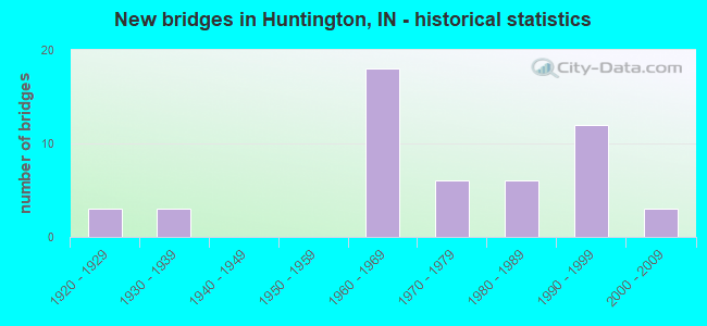
- New bridges - historical statistics
- 31920-1929
- 31930-1939
- 181960-1969
- 61970-1979
- 61980-1989
- 121990-1999
- 32000-2009
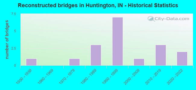
- Reconstructed bridges - Historical Statistics
- 11950-1959
- 01960-1969
- 11970-1979
- 31980-1989
- 71990-1999
- 12000-2009
- 32010-2019
- 22020-2022
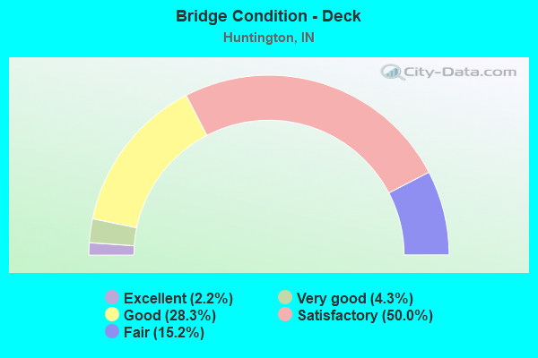
- Bridge Condition - Deck
- 2.2%Excellent
- 4.3%Very good
- 28.3%Good
- 50.0%Satisfactory
- 15.2%Fair
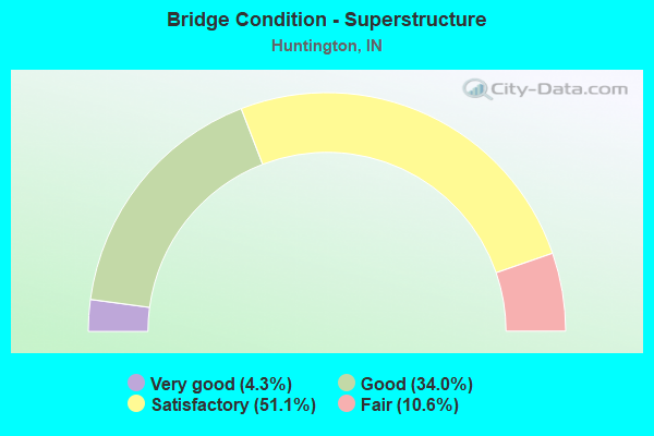
- Bridge Condition - Superstructure
- 4.3%Very good
- 34.0%Good
- 51.1%Satisfactory
- 10.6%Fair
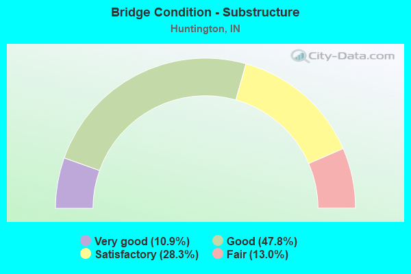
- Bridge Condition - Substructure
- 10.9%Very good
- 47.8%Good
- 28.3%Satisfactory
- 13.0%Fair
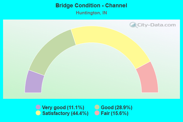
- Bridge Condition - Channel
- 11.1%Very good
- 28.9%Good
- 44.4%Satisfactory
- 15.6%Fair
Find on map >> Show street view
Structure Number: 152, Location: 01.37 S US 224 (Lat: 40.845950, Lng: -85.468661), Route carried "on" structure: State highway 5, Year Built: 1965, Year Reconstructed: 2004, Status: Posted for load-capacity, Structure Length: 4.88m (16.01ft), Average Daily Traffic: 4,015 (year 2019), Truck Traffic: 15%, Average Future Daily Traffic: 10,172 (year 2032), Design Load: HS 20, Features Intersected: WABASH RIVER/HUNT RES
Minimum Vertical Clearance: 30+ m (98+ ft), Kilometerpoint: 28.260, Lanes on structure: 2, Owner: State Highway Agency, Approaching Roadway Width: 9.8m (32.2ft), Material/Design: Steel continuous, Design/Construction: Stringer/Multi-beam, Number Of Spans In Main Unit: 3, Length of Maximum Span: 18.0m (59.1ft), Curb or Sidewalk Widths: Left: 0.2m (0.7ft), Right: 0.2m (0.7ft), Curb-To-Curb Width: 10.2m (33.5ft), Out-to-Out Width: 11.4m (37.4ft)
Condition: Deck: Good, Superstructure: Good, Substructure: Good, Channel: Good, Operating Rating: 55.1 metric tons, Method Used To Determine Operating Rating: Load and Resistance Factor Rating (LRFR) rating reported by rating factor(RF) method using HL-93 loadings, Inventory Rating: 42.4 metric tons, Method Used To Determine Inventory Rating: Load and Resistance Factor Rating (LRFR) rating reported by rating factor(RF) method using HL-93 loadings, Structural Evaluation: Better than present minimum criteria, Deck Geometry: Meets minimum limits, Waterway Adequacy: Equal to present desirable criteria, Approach Roadway Alignment: Equal to present desirable criteria, Designated Inspection Frequency: Every 24 months, Inspection Date: July 2020, Deck Structure Type: Concrete Cast-file-Place, Wearing Surface/Protective System: Wearing Surface: Monolithic Concrete, Deck Protection: Epoxy Coated Reinforcing
Find on map >> Show street view
Structure Number: 153, Location: 00.30 N SR 16 (Lat: 40.919711, Lng: -85.533939), Route carried "on" structure: State highway 5, Year Built: 1931, Year Reconstructed: 1980, Status: Open, Structure Length: 2.38m (7.81ft), Average Daily Traffic: 3,001 (year 2019), Truck Traffic: 11%, Average Future Daily Traffic: 5,996 (year 2034), Design Load: H 20, Features Intersected: CLEAR CREEK
Minimum Vertical Clearance: 30+ m (98+ ft), Kilometerpoint: 38.994, Lanes on structure: 2, Owner: State Highway Agency, Approaching Roadway Width: 7.3m (24.0ft), Material/Design: Prestressed concrete, Design/Construction: Box Beam or Girders - Multiple, Number Of Spans In Main Unit: 1, Length of Maximum Span: 21.3m (69.9ft), Curb-To-Curb Width: 10.6m (34.8ft), Out-to-Out Width: 11.2m (36.7ft)
Condition: Deck: Fair, Superstructure: Fair, Substructure: Fair, Channel: Satisfactory, Operating Rating: 55.3 metric tons, Method Used To Determine Operating Rating: Load Factor (LF), Inventory Rating: 32.7 metric tons, Method Used To Determine Inventory Rating: Load Factor (LF), Structural Evaluation: Somewhat better than minimum adequacy, Deck Geometry: Somewhat better than minimum adequacy, Waterway Adequacy: Equal to present desirable criteria, Approach Roadway Alignment: Equal to present desirable criteria, Designated Inspection Frequency: Every 24 months, Inspection Date: August 2020, Deck Structure Type: Concrete Cast-file-Place, Wearing Surface/Protective System: Wearing Surface: Monolithic Concrete, Deck Protection: Epoxy Coated Reinforcing
Find on map >> Show street view
Structure Number: 268, Location: 02.51 S US 24 (Lat: 40.842369, Lng: -85.527131), Route carried "on" structure: State highway 9, Year Built: 1965, Year Reconstructed: 2001, Status: Open, Structure Length: 3.65m (11.98ft), Average Daily Traffic: 2,297 (year 2020), Truck Traffic: 10%, Average Future Daily Traffic: 4,303 (year 2032), Design Load: HS 20, Features Intersected: LOON CREEK
Minimum Vertical Clearance: 30+ m (98+ ft), Kilometerpoint: 23.014, Lanes on structure: 2, Owner: State Highway Agency, Approaching Roadway Width: 11.6m (38.1ft), Skew: 3 degrees, Material/Design: Concrete continuous, Design/Construction: Slab, Number Of Spans In Main Unit: 3, Length of Maximum Span: 13.6m (44.6ft), Curb-To-Curb Width: 11.7m (38.4ft), Out-to-Out Width: 12.6m (41.3ft)
Condition: Deck: Satisfactory, Superstructure: Satisfactory, Substructure: Satisfactory, Channel: Fair, Operating Rating: 29.5 metric tons, Method Used To Determine Operating Rating: Load and Resistance Factor Rating (LRFR) rating reported by rating factor(RF) method using HL-93 loadings, Inventory Rating: 22.7 metric tons, Method Used To Determine Inventory Rating: Load and Resistance Factor Rating (LRFR) rating reported by rating factor(RF) method using HL-93 loadings, Structural Evaluation: Equal to present minimum criteria, Deck Geometry: Better than present minimum criteria, Waterway Adequacy: Equal to present desirable criteria, Approach Roadway Alignment: Equal to present desirable criteria, Designated Inspection Frequency: Every 24 months, Inspection Date: Febuary 2022, Deck Structure Type: Concrete Cast-file-Place, Wearing Surface/Protective System: Wearing Surface: Latex Concrete
Find on map >> Show street view
Structure Number: 269, Location: 02.51 S US 24 (Lat: 40.842481, Lng: -85.527400), Route carried "on" structure: State highway 9, Year Built: 1965, Year Reconstructed: 2001, Status: Open, Structure Length: 3.65m (11.98ft), Average Daily Traffic: 2,297 (year 2020), Truck Traffic: 10%, Average Future Daily Traffic: 4,303 (year 2032), Design Load: HS 20, Features Intersected: LOON CREEK
Minimum Vertical Clearance: 30+ m (98+ ft), Kilometerpoint: 23.014, Lanes on structure: 2, Owner: State Highway Agency, Approaching Roadway Width: 11.6m (38.1ft), Skew: 3 degrees, Material/Design: Concrete continuous, Design/Construction: Slab, Number Of Spans In Main Unit: 3, Length of Maximum Span: 13.7m (44.9ft), Curb-To-Curb Width: 11.7m (38.4ft), Out-to-Out Width: 12.6m (41.3ft)
Condition: Deck: Satisfactory, Superstructure: Satisfactory, Substructure: Satisfactory, Channel: Fair, Operating Rating: 43.5 metric tons, Method Used To Determine Operating Rating: Load Factor (LF), Inventory Rating: 26.3 metric tons, Method Used To Determine Inventory Rating: Load Factor (LF), Structural Evaluation: Equal to present minimum criteria, Deck Geometry: Better than present minimum criteria, Waterway Adequacy: Equal to present desirable criteria, Approach Roadway Alignment: Equal to present desirable criteria, Designated Inspection Frequency: Every 24 months, Inspection Date: Febuary 2022, Deck Structure Type: Concrete Cast-file-Place, Wearing Surface/Protective System: Wearing Surface: Latex Concrete
Find on map >> Show street view
Structure Number: 27, Location: 00.78 S US 24 (Lat: 40.867100, Lng: -85.533861), Route carried "on" structure: State highway 9, Year Built: 1965, Year Reconstructed: 2016, Status: Open, Structure Length: 4.30m (14.11ft), Average Daily Traffic: 4,317 (year 2019), Truck Traffic: 9%, Average Future Daily Traffic: 5,813 (year 2032), Design Load: HS 25 or greater, Features Intersected: NS RR (HUNTINGTON)
Minimum Vertical Clearance: 30+ m (98+ ft), Kilometerpoint: 25.798, Lanes on structure: 2, Owner: State Highway Agency, Approaching Roadway Width: 11.6m (38.1ft), Skew: 1 degrees, Material/Design: Steel continuous, Design/Construction: Stringer/Multi-beam, Number Of Spans In Main Unit: 3, Length of Maximum Span: 15.9m (52.2ft), Curb-To-Curb Width: 10.1m (33.1ft), Out-to-Out Width: 11.2m (36.7ft)
Condition: Deck: Very good, Superstructure: Very good, Substructure: Very good, Operating Rating: 81.9 metric tons, Method Used To Determine Operating Rating: Load Factor (LF), Inventory Rating: 49.0 metric tons, Method Used To Determine Inventory Rating: Load Factor (LF), Structural Evaluation: Equal to present desirable criteria, Deck Geometry: Somewhat better than minimum adequacy, Underclear: Equal to present minimum criteria, Approach Roadway Alignment: Equal to present minimum criteria, Designated Inspection Frequency: Every 24 months, Inspection Date: June 2020, Deck Structure Type: Concrete Cast-file-Place, Wearing Surface/Protective System: Wearing Surface: Monolithic Concrete, Deck Protection: Epoxy Coated Reinforcing
Find on map >> Show street view
Structure Number: 271, Location: 00.78 S US 24 (Lat: 40.867100, Lng: -85.534150), Route carried "on" structure: State highway 9, Year Built: 1965, Year Reconstructed: 2016, Status: Open, Structure Length: 4.30m (14.11ft), Average Daily Traffic: 4,317 (year 2019), Truck Traffic: 9%, Average Future Daily Traffic: 5,813 (year 2032), Design Load: HS 20, Features Intersected: NS RR (HUNTINGTON)
Minimum Vertical Clearance: 30+ m (98+ ft), Kilometerpoint: 25.798, Lanes on structure: 2, Owner: State Highway Agency, Approaching Roadway Width: 11.6m (38.1ft), Skew: 1 degrees, Material/Design: Steel continuous, Design/Construction: Stringer/Multi-beam, Number Of Spans In Main Unit: 3, Length of Maximum Span: 15.9m (52.2ft), Curb-To-Curb Width: 10.1m (33.1ft), Out-to-Out Width: 11.2m (36.7ft)
Condition: Deck: Very good, Superstructure: Very good, Substructure: Very good, Operating Rating: 81.9 metric tons, Method Used To Determine Operating Rating: Load Factor (LF), Inventory Rating: 49.0 metric tons, Method Used To Determine Inventory Rating: Load Factor (LF), Structural Evaluation: Equal to present desirable criteria, Deck Geometry: Somewhat better than minimum adequacy, Underclear: Equal to present minimum criteria, Approach Roadway Alignment: Equal to present minimum criteria, Designated Inspection Frequency: Every 24 months, Inspection Date: June 2020, Deck Structure Type: Concrete Cast-file-Place, Wearing Surface/Protective System: Wearing Surface: Monolithic Concrete, Deck Protection: Epoxy Coated Reinforcing
Find on map >> Show street view
Structure Number: 272, Location: 00.13 S US 24 (Lat: 40.876369, Lng: -85.532461), Route carried "on" structure: State highway 9, Year Built: 1965, Year Reconstructed: 2020, Status: Open, Structure Length: 10.88m (35.70ft), Average Daily Traffic: 9,290 (year 2020), Truck Traffic: 9%, Average Future Daily Traffic: 11,624 (year 2032), Design Load: HS 20, Features Intersected: WABASH RIVER
Minimum Vertical Clearance: 30+ m (98+ ft), Kilometerpoint: 26.844, Lanes on structure: 4, Owner: State Highway Agency, Approaching Roadway Width: 23.5m (77.1ft), Skew: 20 degrees, Material/Design: Steel continuous, Design/Construction: Stringer/Multi-beam, Number Of Spans In Main Unit: 5, Length of Maximum Span: 23.2m (76.1ft), Curb-To-Curb Width: 22.3m (73.2ft), Out-to-Out Width: 23.3m (76.4ft)
Condition: Deck: Excellent, Superstructure: Good, Substructure: Good, Channel: Satisfactory, Operating Rating: 37.9 metric tons, Method Used To Determine Operating Rating: Load and Resistance Factor Rating (LRFR) rating reported by rating factor(RF) method using HL-93 loadings, Inventory Rating: 29.2 metric tons, Method Used To Determine Inventory Rating: Load and Resistance Factor Rating (LRFR) rating reported by rating factor(RF) method using HL-93 loadings, Structural Evaluation: Better than present minimum criteria, Deck Geometry: Superior to present desirable criteria, Waterway Adequacy: Equal to present desirable criteria, Approach Roadway Alignment: Equal to present desirable criteria, Designated Inspection Frequency: Every 24 months, Inspection Date: December 2020, Deck Structure Type: Concrete Cast-file-Place, Wearing Surface/Protective System: Wearing Surface: Latex Concrete
Find on map >> Show street view
Structure Number: 273, Location: 03.55 N US 24 (Lat: 40.905100, Lng: -85.481389), Route carried "on" structure: State highway 9, Year Built: 1965, Year Reconstructed: 1998, Status: Open, Structure Length: 5.87m (19.26ft), Average Daily Traffic: 2,956 (year 2019), Truck Traffic: 20%, Average Future Daily Traffic: 5,254 (year 2032), Design Load: HS 20, Features Intersected: US 24
Minimum Vertical Clearance: 30+ m (98+ ft), Kilometerpoint: 32.766, Lanes on structure: 2, Lanes under structure: 4, Owner: State Highway Agency, Approaching Roadway Width: 11.3m (37.1ft), Material/Design: Steel continuous, Design/Construction: Stringer/Multi-beam, Number Of Spans In Main Unit: 4, Length of Maximum Span: 18.5m (60.7ft), Curb-To-Curb Width: 11.3m (37.1ft), Out-to-Out Width: 12.2m (40.0ft)
Condition: Deck: Fair, Superstructure: Satisfactory, Substructure: Good, Operating Rating: 71.6 metric tons, Method Used To Determine Operating Rating: Load and Resistance Factor Rating (LRFR) rating reported by rating factor(RF) method using HL-93 loadings, Inventory Rating: 55.1 metric tons, Method Used To Determine Inventory Rating: Load and Resistance Factor Rating (LRFR) rating reported by rating factor(RF) method using HL-93 loadings, Structural Evaluation: Equal to present minimum criteria, Deck Geometry: Somewhat better than minimum adequacy, Underclear: Somewhat better than minimum adequacy, Approach Roadway Alignment: Equal to present minimum criteria, Designated Inspection Frequency: Every 24 months, Inspection Date: June 2020, Deck Structure Type: Concrete Cast-file-Place, Wearing Surface/Protective System: Wearing Surface: Monolithic Concrete, Deck Protection: Epoxy Coated Reinforcing
Find on map >> Show street view
Structure Number: 44, Location: 00.79 W SR 5 (Lat: 40.915731, Lng: -85.545119), Route carried "on" structure: State highway 16, Year Built: 1963, Year Reconstructed: 1987, Status: Open, Structure Length: 2.13m (6.99ft), Average Daily Traffic: 1,222 (year 2020), Truck Traffic: 8%, Average Future Daily Traffic: 1,613 (year 2031), Design Load: HS 20, Features Intersected: CLEAR CREEK
Minimum Vertical Clearance: 30+ m (98+ ft), Kilometerpoint: 8.192, Lanes on structure: 2, Owner: State Highway Agency, Approaching Roadway Width: 9.8m (32.2ft), Material/Design: Concrete, Design/Construction: Arch - Deck, Number Of Spans In Main Unit: 1, Length of Maximum Span: 21.3m (69.9ft), Curb-To-Curb Width: 9.8m (32.2ft), Out-to-Out Width: 10.7m (35.1ft)
Condition: Superstructure: Satisfactory, Substructure: Good, Channel: Very good, Operating Rating: 76.4 metric tons, Method Used To Determine Operating Rating: Field evaluation and documented engineering judgment, Inventory Rating: 45.7 metric tons, Method Used To Determine Inventory Rating: Field evaluation and documented engineering judgment, Structural Evaluation: Equal to present minimum criteria, Deck Geometry: Somewhat better than minimum adequacy, Waterway Adequacy: Equal to present desirable criteria, Approach Roadway Alignment: Equal to present desirable criteria, Designated Inspection Frequency: Every 24 months, Inspection Date: June 2021
Find on map >> Show street view
Structure Number: 6093, Location: 01.23 W SR 9 (Lat: 40.880361, Lng: -85.554581), Route carried "on" structure: US 24, Year Built: 2000, Year Reconstructed: 2020, Status: Open, Structure Length: 3.72m (12.20ft), Average Daily Traffic: 7,849 (year 2019), Truck Traffic: 19%, Average Future Daily Traffic: 7,065 (year 2032), Design Load: HS 20, Features Intersected: CLEAR CREEK
Minimum Vertical Clearance: 30+ m (98+ ft), Kilometerpoint: 8.674, Lanes on structure: 2, Base Highway Network: Yes (, Subroute: 1), Owner: State Highway Agency, Approaching Roadway Width: 12.2m (40.0ft), Skew: 2 degrees, Material/Design: Prestressed concrete continuous, Design/Construction: Stringer/Multi-beam, Number Of Spans In Main Unit: 3, Length of Maximum Span: 12.8m (42.0ft), Curb-To-Curb Width: 12.4m (40.7ft), Out-to-Out Width: 13.3m (43.6ft)
Condition: Deck: Good, Superstructure: Good, Substructure: Very good, Channel: Very good, Operating Rating: 47.3 metric tons, Method Used To Determine Operating Rating: Load and Resistance Factor Rating (LRFR) rating reported by rating factor(RF) method using HL-93 loadings, Inventory Rating: 36.6 metric tons, Method Used To Determine Inventory Rating: Load and Resistance Factor Rating (LRFR) rating reported by rating factor(RF) method using HL-93 loadings, Structural Evaluation: Better than present minimum criteria, Deck Geometry: Better than present minimum criteria, Waterway Adequacy: Equal to present desirable criteria, Approach Roadway Alignment: Equal to present desirable criteria, Designated Inspection Frequency: Every 24 months, Inspection Date: Febuary 2022, Deck Structure Type: Concrete Cast-file-Place, Wearing Surface/Protective System: Wearing Surface: Latex Concrete, Deck Protection: Epoxy Coated Reinforcing
Find on map >> Show street view
Structure Number: 6115, Location: 01.20 E SR 5 (Lat: 40.906831, Lng: -85.491711), Route carried "on" structure: US 24, Year Built: 1965, Status: Open, Structure Length: 0.76m (2.49ft), Average Daily Traffic: 15,543 (year 2020), Truck Traffic: 12%, Average Future Daily Traffic: 18,397 (year 2032), Design Load: HS 20, Features Intersected: HUNTINGTON DRAIN
Minimum Vertical Clearance: 30+ m (98+ ft), Kilometerpoint: 15.578, Lanes on structure: 4, Base Highway Network: Yes (, Subroute: 1), Owner: State Highway Agency, Approaching Roadway Width: 40.8m (133.9ft), Skew: 21 degrees, Material/Design: Steel, Design/Construction: Culvert, Number Of Spans In Main Unit: 2, Length of Maximum Span: 3.2m (10.5ft), Curb-To-Curb Width: 21.9m (71.9ft), Out-to-Out Width: 21.9m (71.9ft)
Condition: Channel: Satisfactory, Culverts: Satisfactory, Structural Evaluation: Equal to present minimum criteria, Deck Geometry: Superior to present desirable criteria, Waterway Adequacy: Equal to present desirable criteria, Approach Roadway Alignment: Equal to present desirable criteria, Designated Inspection Frequency: Every 24 months, Inspection Date: May 2021
Find on map >> Show street view
Structure Number: 613, Location: 04.12 E SR 9 (Lat: 40.911800, Lng: -85.407061), Route carried "on" structure: US 24, Year Built: 1994, Status: Open, Structure Length: 2.56m (8.40ft), Average Daily Traffic: 8,189 (year 2020), Truck Traffic: 12%, Average Future Daily Traffic: 10,774 (year 2032), Design Load: HS 20, Features Intersected: BULL CREEK
Minimum Vertical Clearance: 30+ m (98+ ft), Kilometerpoint: 22.998, Lanes on structure: 2, Base Highway Network: Yes (, Subroute: 1), Owner: State Highway Agency, Approaching Roadway Width: 11.6m (38.1ft), Material/Design: Concrete continuous, Design/Construction: Slab, Number Of Spans In Main Unit: 3, Length of Maximum Span: 9.8m (32.2ft), Curb-To-Curb Width: 15.1m (49.5ft), Out-to-Out Width: 15.6m (51.2ft)
Condition: Deck: Fair, Superstructure: Fair, Substructure: Very good, Channel: Very good, Operating Rating: 58.0 metric tons, Method Used To Determine Operating Rating: Load Factor (LF), Inventory Rating: 34.7 metric tons, Method Used To Determine Inventory Rating: Load Factor (LF), Structural Evaluation: Somewhat better than minimum adequacy, Deck Geometry: Superior to present desirable criteria, Waterway Adequacy: Equal to present desirable criteria, Approach Roadway Alignment: Equal to present desirable criteria, Designated Inspection Frequency: Every 24 months, Inspection Date: August 2021, Deck Structure Type: Concrete Cast-file-Place, Wearing Surface/Protective System: Wearing Surface: Monolithic Concrete, Deck Protection: Epoxy Coated Reinforcing
Find on map >> Show street view
Structure Number: 6135, Location: 04.12 E SR 9 (Lat: 40.911919, Lng: -85.407200), Route carried "on" structure: US 24, Year Built: 1994, Status: Open, Structure Length: 2.56m (8.40ft), Average Daily Traffic: 8,470 (year 2020), Truck Traffic: 13%, Average Future Daily Traffic: 10,774 (year 2032), Design Load: HS 20, Features Intersected: BULL CREEK
Minimum Vertical Clearance: 30+ m (98+ ft), Kilometerpoint: 22.998, Lanes on structure: 2, Base Highway Network: Yes (, Subroute: 1), Owner: State Highway Agency, Approaching Roadway Width: 11.9m (39.0ft), Skew: 10 degrees, Material/Design: Concrete continuous, Design/Construction: Slab, Number Of Spans In Main Unit: 3, Length of Maximum Span: 9.8m (32.2ft), Curb-To-Curb Width: 15.1m (49.5ft), Out-to-Out Width: 15.6m (51.2ft)
Condition: Deck: Fair, Superstructure: Fair, Substructure: Very good, Channel: Very good, Operating Rating: 58.0 metric tons, Method Used To Determine Operating Rating: Load Factor (LF), Inventory Rating: 34.7 metric tons, Method Used To Determine Inventory Rating: Load Factor (LF), Structural Evaluation: Somewhat better than minimum adequacy, Deck Geometry: Superior to present desirable criteria, Waterway Adequacy: Equal to present desirable criteria, Approach Roadway Alignment: Equal to present desirable criteria, Designated Inspection Frequency: Every 24 months, Inspection Date: August 2021, Deck Structure Type: Concrete Cast-file-Place, Wearing Surface/Protective System: Wearing Surface: Monolithic Concrete, Deck Protection: Epoxy Coated Reinforcing
Find on map >> Show street view
Structure Number: 2908, Location: 01.56 E US 24 (Lat: 40.879889, Lng: -85.493389), Route carried "on" structure: US 224, Year Built: 1986, Status: Open, Structure Length: 2.53m (8.30ft), Average Daily Traffic: 10,279 (year 2019), Truck Traffic: 8%, Average Future Daily Traffic: 45,000 (year 2032), Design Load: HS 20, Features Intersected: LITTLE RIVER (N. Fork)
Minimum Vertical Clearance: 30+ m (98+ ft), Kilometerpoint: 2.511, Lanes on structure: 2, Base Highway Network: Yes (, Subroute: 1), Owner: State Highway Agency, Approaching Roadway Width: 10.7m (35.1ft), Material/Design: Steel, Design/Construction: Stringer/Multi-beam, Number Of Spans In Main Unit: 1, Length of Maximum Span: 24.1m (79.1ft), Curb or Sidewalk Widths: Left: 3.2m (10.5ft), Right: 3.2m (10.5ft), Curb-To-Curb Width: 11.0m (36.1ft), Out-to-Out Width: 18.2m (59.7ft)
Condition: Deck: Satisfactory, Superstructure: Good, Substructure: Good, Channel: Good, Operating Rating: 42.8 metric tons, Method Used To Determine Operating Rating: Load and Resistance Factor Rating (LRFR) rating reported by rating factor(RF) method using HL-93 loadings, Inventory Rating: 33.0 metric tons, Method Used To Determine Inventory Rating: Load and Resistance Factor Rating (LRFR) rating reported by rating factor(RF) method using HL-93 loadings, Structural Evaluation: Better than present minimum criteria, Deck Geometry: Meets minimum limits, Waterway Adequacy: Equal to present desirable criteria, Approach Roadway Alignment: Equal to present desirable criteria, Designated Inspection Frequency: Every 24 months, Inspection Date: May 2020, Deck Structure Type: Concrete Cast-file-Place, Wearing Surface/Protective System: Wearing Surface: Monolithic Concrete, Deck Protection: Epoxy Coated Reinforcing
Find on map >> Show street view
Structure Number: 2909, Location: 01.57 E US 24 (Lat: 40.879300, Lng: -85.493100), Route carried "on" structure: US 224, Year Built: 1986, Status: Open, Structure Length: 2.71m (8.89ft), Average Daily Traffic: 10,279 (year 2019), Truck Traffic: 8%, Average Future Daily Traffic: 45,000 (year 2032), Design Load: HS 20, Features Intersected: LITTLE RIVER (S. Fork)
Minimum Vertical Clearance: 30+ m (98+ ft), Kilometerpoint: 2.527, Lanes on structure: 2, Base Highway Network: Yes (, Subroute: 1), Owner: State Highway Agency, Approaching Roadway Width: 10.7m (35.1ft), Material/Design: Steel, Design/Construction: Stringer/Multi-beam, Number Of Spans In Main Unit: 1, Length of Maximum Span: 25.9m (85.0ft), Curb or Sidewalk Widths: Left: 3.2m (10.5ft), Right: 3.2m (10.5ft), Curb-To-Curb Width: 11.0m (36.1ft), Out-to-Out Width: 18.2m (59.7ft)
Condition: Deck: Satisfactory, Superstructure: Satisfactory, Substructure: Satisfactory, Channel: Good, Operating Rating: 40.5 metric tons, Method Used To Determine Operating Rating: Load and Resistance Factor Rating (LRFR) rating reported by rating factor(RF) method using HL-93 loadings, Inventory Rating: 31.4 metric tons, Method Used To Determine Inventory Rating: Load and Resistance Factor Rating (LRFR) rating reported by rating factor(RF) method using HL-93 loadings, Structural Evaluation: Equal to present minimum criteria, Deck Geometry: Meets minimum limits, Waterway Adequacy: Equal to present desirable criteria, Approach Roadway Alignment: Equal to present desirable criteria, Designated Inspection Frequency: Every 24 months, Inspection Date: May 2020, Deck Structure Type: Concrete Cast-file-Place, Wearing Surface/Protective System: Wearing Surface: Monolithic Concrete, Deck Protection: Epoxy Coated Reinforcing
Find on map >> Show street view
Structure Number: 3500032, Location: 0.5 MI E OF CR 300 W (Lat: 40.829189, Lng: -85.500019), Route carried "on" structure: County highway , Year Built: 1981, Status: Open, Structure Length: 2.09m (6.86ft), Average Daily Traffic: 315 (year 2021), Truck Traffic: 5%, Average Future Daily Traffic: 604 (year 2041), Design Load: HS 20, Features Intersected: LOON CREEK, Facility Carried by Structure: DIVISION ROAD
Minimum Vertical Clearance: 30+ m (98+ ft), Kilometerpoint: 0.000, Lanes on structure: 2, Owner: County Highway Agency, Approaching Roadway Width: 6.1m (20.0ft), Skew: 4 degrees, Material/Design: Prestressed concrete, Design/Construction: Box Beam or Girders - Multiple, Number Of Spans In Main Unit: 3, Length of Maximum Span: 8.6m (28.2ft), Curb-To-Curb Width: 7.2m (23.6ft), Out-to-Out Width: 7.4m (24.3ft)
Condition: Deck: Fair, Superstructure: Fair, Substructure: Satisfactory, Channel: Good, Operating Rating: 44.5 metric tons, Method Used To Determine Operating Rating: Load and Resistance Factor (LRFR), Inventory Rating: 36.9 metric tons, Method Used To Determine Inventory Rating: Load and Resistance Factor (LRFR), Structural Evaluation: Somewhat better than minimum adequacy, Deck Geometry: Meets minimum limits, Waterway Adequacy: Better than present minimum criteria, Approach Roadway Alignment: Equal to present desirable criteria, Designated Inspection Frequency: Every 24 months, Inspection Date: September 2021, Deck Structure Type: Concrete Precast Panels, Wearing Surface/Protective System: Wearing Surface: Bituminous
Find on map >> Show street view
Structure Number: 3500033, Location: 0.01 MI W OF DIVISION RD (Lat: 40.825831, Lng: -85.488950), Route carried "on" structure: County highway 39, Year Built: 1995, Status: Open, Structure Length: 1.59m (5.22ft), Average Daily Traffic: 157 (year 2021), Truck Traffic: 5%, Average Future Daily Traffic: 262 (year 2041), Design Load: HS 20, Features Intersected: LOON CREEK, Facility Carried by Structure: CR 200 WEST
Minimum Vertical Clearance: 30+ m (98+ ft), Kilometerpoint: 0.000, Lanes on structure: 2, Owner: County Highway Agency, Approaching Roadway Width: 5.5m (18.0ft), Material/Design: Prestressed concrete, Design/Construction: Box Beam or Girders - Multiple, Number Of Spans In Main Unit: 3, Length of Maximum Span: 6.2m (20.3ft), Curb-To-Curb Width: 7.2m (23.6ft), Out-to-Out Width: 7.4m (24.3ft)
Condition: Deck: Good, Superstructure: Good, Substructure: Good, Channel: Good, Operating Rating: 32.7 metric tons, Method Used To Determine Operating Rating: Field evaluation and documented engineering judgment, Inventory Rating: 32.7 metric tons, Method Used To Determine Inventory Rating: Field evaluation and documented engineering judgment, Structural Evaluation: Better than present minimum criteria, Deck Geometry: Meets minimum limits, Waterway Adequacy: Better than present minimum criteria, Approach Roadway Alignment: Equal to present desirable criteria, Designated Inspection Frequency: Every 24 months, Inspection Date: September 2021, Deck Structure Type: Concrete Precast Panels, Wearing Surface/Protective System: Wearing Surface: Bituminous
Find on map >> Show street view
Structure Number: 3500038, Location: 0.01 MI N OF RIVERSIDE DR (Lat: 40.886281, Lng: -85.451969), Route carried "on" structure: County highway , Year Built: 1995, Status: Posted for load-capacity, Structure Length: 6.31m (20.70ft), Average Daily Traffic: 643 (year 2021), Truck Traffic: 5%, Average Future Daily Traffic: 991 (year 2041), Design Load: HS 20, Features Intersected: LITTLE WABASH RIVER, Facility Carried by Structure: MERIDIAN ROAD
Minimum Vertical Clearance: 30+ m (98+ ft), Kilometerpoint: 0.000, Lanes on structure: 2, Owner: County Highway Agency, Approaching Roadway Width: 8.5m (27.9ft), Skew: 3 degrees, Navigation Control: Yes ( Vertical Clearance: 4.6m (15.1ft), Horizontal Clearance: 20.7m (67.9ft)), Material/Design: Prestressed concrete continuous, Design/Construction: Stringer/Multi-beam, Number Of Spans In Main Unit: 3, Length of Maximum Span: 20.8m (68.2ft), Curb-To-Curb Width: 8.5m (27.9ft), Out-to-Out Width: 9.4m (30.8ft)
Condition: Deck: Good, Superstructure: Good, Substructure: Good, Channel: Satisfactory, Operating Rating: 68.6 metric tons, Method Used To Determine Operating Rating: Load Factor (LF), Inventory Rating: 40.8 metric tons, Method Used To Determine Inventory Rating: Load Factor (LF), Structural Evaluation: Better than present minimum criteria, Deck Geometry: Somewhat better than minimum adequacy, Waterway Adequacy: Equal to present desirable criteria, Approach Roadway Alignment: Equal to present desirable criteria, Designated Inspection Frequency: Every 24 months, Inspection Date: September 2021, Deck Structure Type: Concrete Cast-file-Place, Wearing Surface/Protective System: Wearing Surface: Monolithic Concrete, Deck Protection: Epoxy Coated Reinforcing
Find on map >> Show street view
Structure Number: 3500039, Location: 1.0 MI S OF US 24 (Lat: 40.898531, Lng: -85.413100), Route carried "on" structure: County highway 59, Year Built: 1962, Status: Open, Structure Length: 5.15m (16.90ft), Average Daily Traffic: 750 (year 2021), Truck Traffic: 5%, Average Future Daily Traffic: 1,179 (year 2041), Design Load: HS 20, Features Intersected: LITTLE WABASH RIVER, Facility Carried by Structure: CR 200 EAST
Minimum Vertical Clearance: 30+ m (98+ ft), Kilometerpoint: 0.000, Lanes on structure: 2, Owner: County Highway Agency, Approaching Roadway Width: 6.7m (22.0ft), Skew: 2 degrees, Navigation Control: Yes ( Vertical Clearance: 6.1m (20.0ft), Horizontal Clearance: 16.5m (54.1ft)), Material/Design: Prestressed concrete, Design/Construction: Box Beam or Girders - Multiple, Number Of Spans In Main Unit: 3, Length of Maximum Span: 17.0m (55.8ft), Curb or Sidewalk Widths: Left: 0.3m (1.0ft), Right: 0.3m (1.0ft), Curb-To-Curb Width: 7.5m (24.6ft), Out-to-Out Width: 8.1m (26.6ft)
Condition: Deck: Satisfactory, Superstructure: Satisfactory, Channel: Satisfactory, Operating Rating: 44.6 metric tons, Method Used To Determine Operating Rating: Load and Resistance Factor (LRFR), Inventory Rating: 36.3 metric tons, Method Used To Determine Inventory Rating: Load and Resistance Factor (LRFR), Structural Evaluation: Equal to present minimum criteria, Deck Geometry: Meets minimum limits, Waterway Adequacy: Equal to present desirable criteria, Approach Roadway Alignment: Equal to present desirable criteria, Length Of Structure Improvement: 5.15m (16.90ft), Designated Inspection Frequency: Every 24 months, Underwater Inspection Frequency: Every 60 months, Inspection Date: September 2021, Underwater Inspection Date: September 2017, Bridge Improvement Cost: $352,000, Roadway Improvement Cost: $45,000, Total Project Cost: $397,000 ( Estimate for 2021), Deck Structure Type: Concrete Cast-file-Place, Wearing Surface/Protective System: Wearing Surface: Latex Concrete
Find on map >> Show street view
Structure Number: 3500049, Location: 0.5 MI S OF CR 200 N (Lat: 40.852281, Lng: -85.565031), Route carried "on" structure: County highway 17, Year Built: 1978, Status: Open, Structure Length: 2.59m (8.50ft), Average Daily Traffic: 262 (year 2021), Truck Traffic: 3%, Average Future Daily Traffic: 367 (year 2041), Design Load: H 20, Features Intersected: LOON CREEK, Facility Carried by Structure: CR 600 WEST
Minimum Vertical Clearance: 30+ m (98+ ft), Kilometerpoint: 0.000, Lanes on structure: 2, Owner: County Highway Agency, Approaching Roadway Width: 6.1m (20.0ft), Skew: 2 degrees, Material/Design: Concrete continuous, Design/Construction: Slab, Number Of Spans In Main Unit: 3, Length of Maximum Span: 10.1m (33.1ft), Curb-To-Curb Width: 8.6m (28.2ft), Out-to-Out Width: 9.3m (30.5ft)
Condition: Deck: Satisfactory, Superstructure: Satisfactory, Substructure: Good, Channel: Satisfactory, Operating Rating: 52.4 metric tons, Method Used To Determine Operating Rating: Load and Resistance Factor (LRFR), Inventory Rating: 43.4 metric tons, Method Used To Determine Inventory Rating: Load and Resistance Factor (LRFR), Structural Evaluation: Equal to present minimum criteria, Deck Geometry: Equal to present minimum criteria, Waterway Adequacy: Better than present minimum criteria, Approach Roadway Alignment: Equal to present minimum criteria, Designated Inspection Frequency: Every 24 months, Inspection Date: September 2021, Deck Structure Type: Concrete Cast-file-Place, Wearing Surface/Protective System: Wearing Surface: Monolithic Concrete
Find on map >> Show street view
Structure Number: 3500058, Location: 0.5 MI W OF CR 300 N (Lat: 40.960611, Lng: -85.516211), Route carried "on" structure: County highway 74, Year Built: 1920, Year Reconstructed: 1970, Status: Open, Structure Length: 1.52m (4.99ft), Average Daily Traffic: 315 (year 2021), Truck Traffic: 2%, Average Future Daily Traffic: 525 (year 2041), Design Load: HS 20, Features Intersected: CLEAR CREEK, Facility Carried by Structure: CR 900 NORTH
Minimum Vertical Clearance: 30+ m (98+ ft), Kilometerpoint: 0.000, Lanes on structure: 2, Owner: County Highway Agency, Approaching Roadway Width: 5.5m (18.0ft), Material/Design: Prestressed concrete, Design/Construction: Box Beam or Girders - Multiple, Number Of Spans In Main Unit: 1, Length of Maximum Span: 14.2m (46.6ft), Curb-To-Curb Width: 7.2m (23.6ft), Out-to-Out Width: 7.4m (24.3ft)
Condition: Deck: Satisfactory, Superstructure: Satisfactory, Substructure: Fair, Channel: Fair, Operating Rating: 48.4 metric tons, Method Used To Determine Operating Rating: Load and Resistance Factor (LRFR), Inventory Rating: 40.1 metric tons, Method Used To Determine Inventory Rating: Load and Resistance Factor (LRFR), Structural Evaluation: Somewhat better than minimum adequacy, Deck Geometry: Meets minimum limits, Waterway Adequacy: Better than present minimum criteria, Approach Roadway Alignment: Equal to present desirable criteria, Designated Inspection Frequency: Every 24 months, Inspection Date: September 2021, Deck Structure Type: Concrete Precast Panels, Wearing Surface/Protective System: Wearing Surface: Bituminous
Find on map >> Show street view
Structure Number: 350006, Location: 0.4 MI E OF CLEAR CREEK R (Lat: 40.945831, Lng: -85.529111), Route carried "on" structure: County highway 70, Year Built: 1970, Year Reconstructed: 2013, Status: Open, Structure Length: 2.09m (6.86ft), Average Daily Traffic: 315 (year 2021), Truck Traffic: 2%, Average Future Daily Traffic: 525 (year 2041), Design Load: HS 25 or greater, Features Intersected: CLEAR CREEK, Facility Carried by Structure: CR 800 NORTH
Minimum Vertical Clearance: 30+ m (98+ ft), Kilometerpoint: 0.000, Lanes on structure: 2, Owner: County Highway Agency, Approaching Roadway Width: 6.1m (20.0ft), Material/Design: Prestressed concrete, Design/Construction: Box Beam or Girders - Multiple, Number Of Spans In Main Unit: 1, Length of Maximum Span: 20.1m (65.9ft), Curb-To-Curb Width: 7.9m (25.9ft), Out-to-Out Width: 8.1m (26.6ft)
Condition: Deck: Good, Superstructure: Good, Substructure: Satisfactory, Channel: Satisfactory, Operating Rating: 32.7 metric tons, Method Used To Determine Operating Rating: Field evaluation and documented engineering judgment, Inventory Rating: 32.7 metric tons, Method Used To Determine Inventory Rating: Field evaluation and documented engineering judgment, Structural Evaluation: Equal to present minimum criteria, Deck Geometry: Somewhat better than minimum adequacy, Waterway Adequacy: Better than present minimum criteria, Approach Roadway Alignment: Equal to present desirable criteria, Designated Inspection Frequency: Every 24 months, Inspection Date: September 2021, Deck Structure Type: Concrete Precast Panels, Wearing Surface/Protective System: Wearing Surface: Bituminous, Membrane: Preformed Fabric
Find on map >> Show street view
Structure Number: 3500061, Location: 0.6 MI W OF CLEAR CREEK R (Lat: 40.931211, Lng: -85.533669), Route carried "on" structure: County highway 68, Year Built: 1976, Status: Open, Structure Length: 2.78m (9.12ft), Average Daily Traffic: 160 (year 2021), Truck Traffic: 2%, Average Future Daily Traffic: 268 (year 2041), Design Load: HS 20, Features Intersected: CLEAR CREEK, Facility Carried by Structure: CR 700 NORTH
Minimum Vertical Clearance: 30+ m (98+ ft), Kilometerpoint: 0.000, Lanes on structure: 2, Owner: County Highway Agency, Approaching Roadway Width: 6.1m (20.0ft), Skew: 1 degrees, Material/Design: Concrete continuous, Design/Construction: Slab, Number Of Spans In Main Unit: 3, Length of Maximum Span: 10.5m (34.4ft), Curb-To-Curb Width: 8.6m (28.2ft), Out-to-Out Width: 9.3m (30.5ft)
Condition: Deck: Satisfactory, Superstructure: Satisfactory, Substructure: Good, Channel: Good, Operating Rating: 45.7 metric tons, Method Used To Determine Operating Rating: Load and Resistance Factor (LRFR), Inventory Rating: 37.9 metric tons, Method Used To Determine Inventory Rating: Load and Resistance Factor (LRFR), Structural Evaluation: Equal to present minimum criteria, Deck Geometry: Equal to present minimum criteria, Waterway Adequacy: Equal to present desirable criteria, Approach Roadway Alignment: Equal to present desirable criteria, Length Of Structure Improvement: 2.80m (9.19ft), Designated Inspection Frequency: Every 24 months, Inspection Date: September 2021, Bridge Improvement Cost: $276,000, Roadway Improvement Cost: $45,000, Total Project Cost: $321,000 ( Estimate for 2021), Deck Structure Type: Concrete Cast-file-Place, Wearing Surface/Protective System: Wearing Surface: Monolithic Concrete
Find on map >> Show street view
Structure Number: 3500062, Location: 0.05 MI N OF CR 750 N (Lat: 40.938839, Lng: -85.530331), Route carried "on" structure: County highway 31, Year Built: 1973, Status: Open, Structure Length: 2.64m (8.66ft), Average Daily Traffic: 321 (year 2021), Truck Traffic: 2%, Average Future Daily Traffic: 536 (year 2041), Design Load: HS 20, Features Intersected: CLEAR CREEK, Facility Carried by Structure: CLEAR CREEK ROAD
Minimum Vertical Clearance: 30+ m (98+ ft), Kilometerpoint: 0.000, Lanes on structure: 2, Owner: County Highway Agency, Approaching Roadway Width: 6.1m (20.0ft), Skew: 1 degrees, Material/Design: Prestressed concrete, Design/Construction: Box Beam or Girders - Multiple, Number Of Spans In Main Unit: 3, Length of Maximum Span: 10.0m (32.8ft), Curb-To-Curb Width: 8.2m (26.9ft), Out-to-Out Width: 8.6m (28.2ft)
Condition: Deck: Fair, Superstructure: Fair, Substructure: Fair, Channel: Satisfactory, Operating Rating: 48.7 metric tons, Method Used To Determine Operating Rating: Load and Resistance Factor (LRFR), Inventory Rating: 40.9 metric tons, Method Used To Determine Inventory Rating: Load and Resistance Factor (LRFR), Structural Evaluation: Somewhat better than minimum adequacy, Deck Geometry: Somewhat better than minimum adequacy, Waterway Adequacy: Better than present minimum criteria, Approach Roadway Alignment: Equal to present minimum criteria, Length Of Structure Improvement: 3.54m (11.61ft), Designated Inspection Frequency: Every 24 months, Inspection Date: September 2021, Bridge Improvement Cost: $650,000, Roadway Improvement Cost: $360,000, Total Project Cost: $1,010,000 ( Estimate for 2021), Deck Structure Type: Concrete Precast Panels, Wearing Surface/Protective System: Wearing Surface: Bituminous
Find on map >> Show street view
Structure Number: 3500065, Location: 0.4 MI E OF CR 100 E (Lat: 40.932031, Lng: -85.426469), Route carried "on" structure: County highway 68, Year Built: 1931, Year Reconstructed: 1995, Status: Open, Structure Length: 1.23m (4.04ft), Average Daily Traffic: 132 (year 2021), Truck Traffic: 2%, Average Future Daily Traffic: 212 (year 2041), Design Load: HS 20, Features Intersected: BULL CREEK, Facility Carried by Structure: CR 700 NORTH
Minimum Vertical Clearance: 30+ m (98+ ft), Kilometerpoint: 0.000, Lanes on structure: 2, Owner: County Highway Agency, Approaching Roadway Width: 5.5m (18.0ft), Skew: 3 degrees, Material/Design: Prestressed concrete, Design/Construction: Box Beam or Girders - Multiple, Number Of Spans In Main Unit: 1, Length of Maximum Span: 11.7m (38.4ft), Curb-To-Curb Width: 7.2m (23.6ft), Out-to-Out Width: 7.3m (24.0ft)
Condition: Deck: Satisfactory, Superstructure: Satisfactory, Substructure: Fair, Channel: Fair, Operating Rating: 55.2 metric tons, Method Used To Determine Operating Rating: Load Factor (LF), Inventory Rating: 33.0 metric tons, Method Used To Determine Inventory Rating: Load Factor (LF), Structural Evaluation: Somewhat better than minimum adequacy, Deck Geometry: Meets minimum limits, Waterway Adequacy: Better than present minimum criteria, Approach Roadway Alignment: Equal to present minimum criteria, Designated Inspection Frequency: Every 24 months, Inspection Date: September 2021, Deck Structure Type: Concrete Precast Panels, Wearing Surface/Protective System: Wearing Surface: Bituminous
Find on map >> Show street view
Structure Number: 3500066, Location: 0.5 MI N OF CR 600 N (Lat: 40.922931, Lng: -85.412889), Route carried "on" structure: County highway 177, Year Built: 1995, Status: Open, Structure Length: 1.59m (5.22ft), Average Daily Traffic: 134 (year 2021), Truck Traffic: 3%, Average Future Daily Traffic: 214 (year 2041), Design Load: HS 20, Features Intersected: BULL CREEK, Facility Carried by Structure: CR 200 EAST
Minimum Vertical Clearance: 30+ m (98+ ft), Kilometerpoint: 0.000, Lanes on structure: 2, Owner: County Highway Agency, Approaching Roadway Width: 7.6m (24.9ft), Skew: 2 degrees, Material/Design: Wood or Timber, Design/Construction: Slab, Number Of Spans In Main Unit: 3, Length of Maximum Span: 7.9m (25.9ft), Curb or Sidewalk Widths: Left: 0.1m (0.3ft), Right: 0.1m (0.3ft), Curb-To-Curb Width: 7.6m (24.9ft), Out-to-Out Width: 7.8m (25.6ft)
Condition: Deck: Satisfactory, Superstructure: Satisfactory, Substructure: Satisfactory, Channel: Satisfactory, Operating Rating: 71.1 metric tons, Method Used To Determine Operating Rating: Load and Resistance Factor (LRFR), Inventory Rating: 52.8 metric tons, Method Used To Determine Inventory Rating: Load and Resistance Factor (LRFR), Structural Evaluation: Equal to present minimum criteria, Deck Geometry: Somewhat better than minimum adequacy, Waterway Adequacy: Better than present minimum criteria, Approach Roadway Alignment: Equal to present desirable criteria, Designated Inspection Frequency: Every 24 months, Inspection Date: September 2021, Deck Structure Type: Wood or Timber, Wearing Surface/Protective System: Wearing Surface: Bituminous, Deck Protection: Internally Sealed
Find on map >> Show street view
Structure Number: 3500067, Location: 1.0 MI NE OF CR 600 N (Lat: 40.925261, Lng: -85.420661), Route carried "on" structure: County highway , Year Built: 1982, Status: Open, Structure Length: 1.92m (6.30ft), Average Daily Traffic: 268 (year 2021), Truck Traffic: 2%, Average Future Daily Traffic: 428 (year 2041), Design Load: HS 20, Features Intersected: BULL CREEK, Facility Carried by Structure: OLD FORT WAYNE RD
Minimum Vertical Clearance: 30+ m (98+ ft), Kilometerpoint: 0.000, Lanes on structure: 2, Owner: County Highway Agency, Approaching Roadway Width: 6.1m (20.0ft), Skew: 1 degrees, Material/Design: Concrete continuous, Design/Construction: Slab, Number Of Spans In Main Unit: 3, Length of Maximum Span: 7.0m (23.0ft), Curb-To-Curb Width: 8.0m (26.2ft), Out-to-Out Width: 8.8m (28.9ft)
Condition: Deck: Satisfactory, Superstructure: Satisfactory, Substructure: Good, Channel: Satisfactory, Operating Rating: 32.7 metric tons, Method Used To Determine Operating Rating: Field evaluation and documented engineering judgment, Inventory Rating: 32.7 metric tons, Method Used To Determine Inventory Rating: Field evaluation and documented engineering judgment, Structural Evaluation: Equal to present minimum criteria, Deck Geometry: Somewhat better than minimum adequacy, Waterway Adequacy: Equal to present minimum criteria, Approach Roadway Alignment: Equal to present minimum criteria, Designated Inspection Frequency: Every 24 months, Inspection Date: September 2021, Deck Structure Type: Concrete Cast-file-Place, Wearing Surface/Protective System: Wearing Surface: Bituminous
Find on map >> Show street view
Structure Number: 3500069, Location: 0.7 MI W OF US 24 (Lat: 40.917369, Lng: -85.406650), Route carried "on" structure: County highway 66, Year Built: 1995, Status: Open, Structure Length: 1.89m (6.20ft), Average Daily Traffic: 160 (year 2021), Truck Traffic: 2%, Average Future Daily Traffic: 241 (year 2041), Design Load: HS 20, Features Intersected: BULL CREEK, Facility Carried by Structure: CR 600 NORTH
Minimum Vertical Clearance: 30+ m (98+ ft), Kilometerpoint: 0.000, Lanes on structure: 2, Owner: County Highway Agency, Approaching Roadway Width: 6.7m (22.0ft), Material/Design: Wood or Timber, Design/Construction: Slab, Number Of Spans In Main Unit: 3, Length of Maximum Span: 7.9m (25.9ft), Curb or Sidewalk Widths: Left: 0.2m (0.7ft), Right: 0.2m (0.7ft), Curb-To-Curb Width: 7.4m (24.3ft), Out-to-Out Width: 7.9m (25.9ft)
Condition: Deck: Satisfactory, Superstructure: Satisfactory, Substructure: Good, Channel: Satisfactory, Operating Rating: 67.4 metric tons, Method Used To Determine Operating Rating: Load and Resistance Factor (LRFR), Inventory Rating: 50.1 metric tons, Method Used To Determine Inventory Rating: Load and Resistance Factor (LRFR), Structural Evaluation: Equal to present minimum criteria, Deck Geometry: Somewhat better than minimum adequacy, Waterway Adequacy: Better than present minimum criteria, Approach Roadway Alignment: Equal to present minimum criteria, Designated Inspection Frequency: Every 24 months, Inspection Date: September 2021, Deck Structure Type: Wood or Timber, Wearing Surface/Protective System: Wearing Surface: Bituminous, Deck Protection: Internally Sealed
Find on map >> Show street view
Structure Number: 350008, Location: 0.8 N OF CR 1000 N (Lat: 40.988039, Lng: -85.363361), Route carried "on" structure: County highway , Year Built: 1988, Status: Open, Structure Length: 1.65m (5.41ft), Average Daily Traffic: 214 (year 2021), Truck Traffic: 2%, Average Future Daily Traffic: 348 (year 2041), Features Intersected: CALF CREEK, Facility Carried by Structure: ROANOKE ROAD
Minimum Vertical Clearance: 30+ m (98+ ft), Kilometerpoint: 0.000, Lanes on structure: 2, Owner: County Highway Agency, Approaching Roadway Width: 6.1m (20.0ft), Material/Design: Wood or Timber, Design/Construction: Slab, Number Of Spans In Main Unit: 3, Length of Maximum Span: 7.9m (25.9ft), Curb or Sidewalk Widths: Left: 0.2m (0.7ft), Right: 0.2m (0.7ft), Curb-To-Curb Width: 7.4m (24.3ft), Out-to-Out Width: 7.9m (25.9ft)
Condition: Deck: Satisfactory, Superstructure: Satisfactory, Substructure: Satisfactory, Channel: Good, Operating Rating: 68.2 metric tons, Method Used To Determine Operating Rating: Load and Resistance Factor (LRFR), Inventory Rating: 50.7 metric tons, Method Used To Determine Inventory Rating: Load and Resistance Factor (LRFR), Structural Evaluation: Equal to present minimum criteria, Deck Geometry: Somewhat better than minimum adequacy, Waterway Adequacy: Better than present minimum criteria, Approach Roadway Alignment: Equal to present desirable criteria, Designated Inspection Frequency: Every 24 months, Inspection Date: September 2021, Deck Structure Type: Wood or Timber, Wearing Surface/Protective System: Wearing Surface: Bituminous, Deck Protection: Internally Sealed
Find on map >> Show street view
Structure Number: 3500081, Location: 0.9 MI E OF RANGELINE RD (Lat: 40.904961, Lng: -85.544669), Route carried "on" structure: County highway 64, Year Built: 1966, Status: Open, Structure Length: 3.41m (11.19ft), Average Daily Traffic: 375 (year 2021), Truck Traffic: 5%, Average Future Daily Traffic: 509 (year 2041), Features Intersected: CLEAR CREEK, Facility Carried by Structure: CR 500 NORTH
Minimum Vertical Clearance: 30+ m (98+ ft), Kilometerpoint: 0.000, Lanes on structure: 2, Owner: County Highway Agency, Approaching Roadway Width: 6.4m (21.0ft), Skew: 1 degrees, Material/Design: Prestressed concrete, Design/Construction: Box Beam or Girders - Single/Spread, Number Of Spans In Main Unit: 3, Length of Maximum Span: 11.5m (37.7ft), Curb or Sidewalk Widths: Left: 0.3m (1.0ft), Right: 0.3m (1.0ft), Curb-To-Curb Width: 7.3m (24.0ft), Out-to-Out Width: 7.9m (25.9ft)
Condition: Deck: Satisfactory, Superstructure: Satisfactory, Substructure: Good, Channel: Fair, Operating Rating: 32.7 metric tons, Method Used To Determine Operating Rating: Field evaluation and documented engineering judgment, Inventory Rating: 32.7 metric tons, Method Used To Determine Inventory Rating: Field evaluation and documented engineering judgment, Structural Evaluation: Equal to present minimum criteria, Deck Geometry: Somewhat better than minimum adequacy, Waterway Adequacy: Better than present minimum criteria, Approach Roadway Alignment: Equal to present minimum criteria, Designated Inspection Frequency: Every 24 months, Inspection Date: September 2021, Deck Structure Type: Concrete Cast-file-Place, Wearing Surface/Protective System: Wearing Surface: Latex Concrete
Find on map >> Show street view
Structure Number: 3500082, Location: 2.2 MI N OF US 24 (Lat: 40.898761, Lng: -85.545489), Route carried "on" structure: County highway , Year Built: 1967, Status: Open, Structure Length: 3.37m (11.06ft), Average Daily Traffic: 321 (year 2021), Truck Traffic: 2%, Average Future Daily Traffic: 482 (year 2041), Design Load: HS 20, Features Intersected: CLEAR CREEK, Facility Carried by Structure: RANGELINE ROAD
Minimum Vertical Clearance: 30+ m (98+ ft), Kilometerpoint: 0.000, Lanes on structure: 2, Owner: County Highway Agency, Approaching Roadway Width: 6.4m (21.0ft), Skew: 1 degrees, Material/Design: Concrete continuous, Design/Construction: Slab, Number Of Spans In Main Unit: 3, Length of Maximum Span: 13.4m (44.0ft), Curb or Sidewalk Widths: Left: 0.3m (1.0ft), Right: 0.3m (1.0ft), Curb-To-Curb Width: 7.7m (25.3ft), Out-to-Out Width: 8.8m (28.9ft)
Condition: Deck: Satisfactory, Superstructure: Satisfactory, Substructure: Satisfactory, Channel: Satisfactory, Operating Rating: 40.2 metric tons, Method Used To Determine Operating Rating: Load and Resistance Factor (LRFR), Inventory Rating: 33.3 metric tons, Method Used To Determine Inventory Rating: Load and Resistance Factor (LRFR), Structural Evaluation: Equal to present minimum criteria, Deck Geometry: Somewhat better than minimum adequacy, Waterway Adequacy: Better than present minimum criteria, Approach Roadway Alignment: Equal to present minimum criteria, Designated Inspection Frequency: Every 24 months, Inspection Date: September 2021, Deck Structure Type: Concrete Cast-file-Place, Wearing Surface/Protective System: Wearing Surface: Latex Concrete
Find on map >> Show street view
Structure Number: 3500083, Location: 0.05 MI S OF US 24 (Lat: 40.879511, Lng: -85.542950), Route carried "on" structure: County highway 17, Year Built: 1920, Year Reconstructed: 2015, Status: Posted for load, Structure Length: 7.92m (25.98ft), Average Daily Traffic: 972 (year 2021), Truck Traffic: 1%, Average Future Daily Traffic: 1,576 (year 2041), Features Intersected: WABASH RIVER, Facility Carried by Structure: CR 475 WEST
Minimum Vertical Clearance: 4.27m (14.01ft), Kilometerpoint: 0.000, Lanes on structure: 1, Owner: County Highway Agency, Approaching Roadway Width: 5.5m (18.0ft), Navigation Control: Yes ( Vertical Clearance: 5.3m (17.4ft), Horizontal Clearance: 42.7m (140.1ft)), Material/Design: Aluminum, Iron, Design/Construction: Truss - Thru, Number Of Spans In Main Unit: 2, Length of Maximum Span: 39.0m (128.0ft), Curb-To-Curb Width: 5.3m (17.4ft), Out-to-Out Width: 5.5m (18.0ft)
Condition: Deck: Satisfactory, Superstructure: Satisfactory, Substructure: Satisfactory, Channel: Good, Operating Rating: 42.7 metric tons, Method Used To Determine Operating Rating: Load Factor (LF), Inventory Rating: 22.4 metric tons, Method Used To Determine Inventory Rating: Load Factor (LF), Structural Evaluation: Somewhat better than minimum adequacy, Deck Geometry: High priority of replacement, Waterway Adequacy: Better than present minimum criteria, Approach Roadway Alignment: High priority of corrective action, Designated Inspection Frequency: Every 24 months, Critical Feature Inspection Frequency: Every 24 months, Underwater Inspection Frequency: Every 60 months, Inspection Date: September 2021, Critical Feature Inspection Date: September 2021, Underwater Inspection Date: September 2017, Deck Structure Type: Wood or Timber, Wearing Surface/Protective System: Wearing Surface: Bituminous, Deck Protection: Internally Sealed
Find on map >> Show street view
Structure Number: 3500084, Location: 0.5 MI S OF WATERWORKS RD (Lat: 40.853389, Lng: -85.489781), Route carried "on" structure: County highway 39, Year Built: 1993, Status: Open, Structure Length: 10.08m (33.07ft), Average Daily Traffic: 348 (year 2021), Truck Traffic: 3%, Average Future Daily Traffic: 509 (year 2041), Design Load: HS 20, Features Intersected: WABASH RIVER, Facility Carried by Structure: CR 200 WEST
Minimum Vertical Clearance: 30+ m (98+ ft), Kilometerpoint: 0.000, Lanes on structure: 2, Owner: County Highway Agency, Approaching Roadway Width: 6.7m (22.0ft), Skew: 3 degrees, Navigation Control: Yes ( Vertical Clearance: 6.6m (21.7ft), Horizontal Clearance: 42.7m (140.1ft)), Material/Design: Prestressed concrete continuous, Design/Construction: Stringer/Multi-beam, Number Of Spans In Main Unit: 4, Length of Maximum Span: 25.1m (82.3ft), Curb-To-Curb Width: 8.5m (27.9ft), Out-to-Out Width: 9.4m (30.8ft)
Condition: Deck: Good, Superstructure: Good, Substructure: Good, Channel: Good, Operating Rating: 32.7 metric tons, Method Used To Determine Operating Rating: Field evaluation and documented engineering judgment, Inventory Rating: 32.7 metric tons, Method Used To Determine Inventory Rating: Field evaluation and documented engineering judgment, Structural Evaluation: Better than present minimum criteria, Deck Geometry: Equal to present minimum criteria, Waterway Adequacy: Equal to present desirable criteria, Approach Roadway Alignment: Equal to present desirable criteria, Designated Inspection Frequency: Every 24 months, Underwater Inspection Frequency: Every 60 months, Inspection Date: September 2021, Underwater Inspection Date: September 2017, Deck Structure Type: Concrete Cast-file-Place, Wearing Surface/Protective System: Wearing Surface: Monolithic Concrete, Deck Protection: Epoxy Coated Reinforcing
Find on map >> Show street view
Structure Number: 3500085, Location: 0.4 MI N OF DIVISION RD (Lat: 40.834031, Lng: -85.508600), Route carried "on" structure: County highway 349, Year Built: 2001, Status: Open, Structure Length: 1.76m (5.77ft), Average Daily Traffic: 1,182 (year 2021), Truck Traffic: 5%, Average Future Daily Traffic: 2,102 (year 2041), Design Load: HS 20, Features Intersected: LOON CREEK, Facility Carried by Structure: CR 300 WEST
Minimum Vertical Clearance: 30+ m (98+ ft), Kilometerpoint: 0.000, Lanes on structure: 2, Owner: County Highway Agency, Approaching Roadway Width: 6.1m (20.0ft), Skew: 1 degrees, Material/Design: Wood or Timber, Design/Construction: Slab, Number Of Spans In Main Unit: 3, Length of Maximum Span: 7.9m (25.9ft), Curb or Sidewalk Widths: Left: 0.2m (0.7ft), Right: 0.2m (0.7ft), Curb-To-Curb Width: 8.6m (28.2ft), Out-to-Out Width: 9.1m (29.9ft)
Condition: Deck: Good, Superstructure: Good, Substructure: Good, Channel: Good, Operating Rating: 68.4 metric tons, Method Used To Determine Operating Rating: Load and Resistance Factor (LRFR), Inventory Rating: 50.8 metric tons, Method Used To Determine Inventory Rating: Load and Resistance Factor (LRFR), Structural Evaluation: Better than present minimum criteria, Deck Geometry: Somewhat better than minimum adequacy, Waterway Adequacy: Better than present minimum criteria, Approach Roadway Alignment: Equal to present desirable criteria, Designated Inspection Frequency: Every 24 months, Inspection Date: September 2021, Deck Structure Type: Wood or Timber, Wearing Surface/Protective System: Wearing Surface: Bituminous, Deck Protection: Internally Sealed
Find on map >> Show street view
Structure Number: 3500086, Location: 0.3 MI S OF CR 100 N (Lat: 40.840839, Lng: -85.547281), Route carried "on" structure: County highway 119, Year Built: 1993, Status: Open, Structure Length: 1.46m (4.79ft), Average Daily Traffic: 105 (year 2021), Truck Traffic: 2%, Average Future Daily Traffic: 157 (year 2041), Design Load: HS 20, Features Intersected: LOON CREEK, Facility Carried by Structure: CR 500 WEST
Minimum Vertical Clearance: 30+ m (98+ ft), Kilometerpoint: 0.000, Lanes on structure: 2, Owner: County Highway Agency, Approaching Roadway Width: 5.2m (17.1ft), Material/Design: Wood or Timber, Design/Construction: Slab, Number Of Spans In Main Unit: 3, Length of Maximum Span: 7.3m (24.0ft), Curb or Sidewalk Widths: Left: 0.1m (0.3ft), Right: 0.1m (0.3ft), Curb-To-Curb Width: 7.4m (24.3ft), Out-to-Out Width: 7.8m (25.6ft)
Condition: Deck: Good, Superstructure: Good, Substructure: Good, Channel: Good, Operating Rating: 79.1 metric tons, Method Used To Determine Operating Rating: Load and Resistance Factor (LRFR), Inventory Rating: 58.8 metric tons, Method Used To Determine Inventory Rating: Load and Resistance Factor (LRFR), Structural Evaluation: Better than present minimum criteria, Deck Geometry: Somewhat better than minimum adequacy, Waterway Adequacy: Better than present minimum criteria, Approach Roadway Alignment: Equal to present desirable criteria, Designated Inspection Frequency: Every 24 months, Inspection Date: September 2021, Deck Structure Type: Wood or Timber, Wearing Surface/Protective System: Wearing Surface: Bituminous
Find on map >> Show street view
Structure Number: 3500087, Location: 0.6 MI W OF CR 500 W (Lat: 40.843689, Lng: -85.552411), Route carried "on" structure: County highway 46, Year Built: 1964, Status: Open, Structure Length: 2.50m (8.20ft), Average Daily Traffic: 131 (year 2021), Truck Traffic: 3%, Average Future Daily Traffic: 210 (year 2041), Features Intersected: LOON CREEK, Facility Carried by Structure: CR 100 NORTH
Minimum Vertical Clearance: 30+ m (98+ ft), Kilometerpoint: 0.000, Lanes on structure: 2, Owner: County Highway Agency, Approaching Roadway Width: 5.5m (18.0ft), Skew: 3 degrees, Material/Design: Concrete continuous, Design/Construction: Slab, Number Of Spans In Main Unit: 3, Length of Maximum Span: 9.8m (32.2ft), Curb or Sidewalk Widths: Left: 0.2m (0.7ft), Right: 0.2m (0.7ft), Curb-To-Curb Width: 6.7m (22.0ft), Out-to-Out Width: 7.3m (24.0ft)
Condition: Deck: Satisfactory, Superstructure: Satisfactory, Substructure: Good, Channel: Fair, Operating Rating: 32.7 metric tons, Method Used To Determine Operating Rating: Field evaluation and documented engineering judgment, Inventory Rating: 32.7 metric tons, Method Used To Determine Inventory Rating: Field evaluation and documented engineering judgment, Structural Evaluation: Equal to present minimum criteria, Deck Geometry: Meets minimum limits, Waterway Adequacy: Better than present minimum criteria, Approach Roadway Alignment: Equal to present desirable criteria, Designated Inspection Frequency: Every 24 months, Inspection Date: September 2021, Deck Structure Type: Concrete Cast-file-Place, Wearing Surface/Protective System: Wearing Surface: Bituminous
Find on map >> Show street view
Structure Number: 3500088, Location: 0.01 MI N OF RIVERSDIE DR (Lat: 40.881539, Lng: -85.471061), Route carried "on" structure: City street , Year Built: 1960, Status: Open, Structure Length: 7.48m (24.54ft), Average Daily Traffic: 4,449 (year 2021), Truck Traffic: 10%, Average Future Daily Traffic: 7,049 (year 2041), Design Load: HS 20, Features Intersected: LITTLE WABASH RIVER, Facility Carried by Structure: BROADWAY STREET
Minimum Vertical Clearance: 30+ m (98+ ft), Kilometerpoint: 0.000, Lanes on structure: 2, Owner: County Highway Agency, Approaching Roadway Width: 7.6m (24.9ft), Navigation Control: Yes ( Vertical Clearance: 4.4m (14.4ft), Horizontal Clearance: 28.7m (94.2ft)), Material/Design: Concrete continuous, Design/Construction: Stringer/Multi-beam, Number Of Spans In Main Unit: 3, Length of Maximum Span: 29.9m (98.1ft), Curb or Sidewalk Widths: Left: 1.5m (4.9ft), Right: 0.6m (2.0ft), Curb-To-Curb Width: 7.9m (25.9ft), Out-to-Out Width: 10.1m (33.1ft)
Condition: Deck: Fair, Superstructure: Satisfactory, Substructure: Good, Channel: Fair, Operating Rating: 32.7 metric tons, Method Used To Determine Operating Rating: Field evaluation and documented engineering judgment, Inventory Rating: 32.7 metric tons, Method Used To Determine Inventory Rating: Field evaluation and documented engineering judgment, Structural Evaluation: Equal to present minimum criteria, Deck Geometry: High priority of corrective action, Waterway Adequacy: Equal to present minimum criteria, Approach Roadway Alignment: High priority of corrective action, Designated Inspection Frequency: Every 24 months, Inspection Date: September 2021, Deck Structure Type: Concrete Cast-file-Place, Wearing Surface/Protective System: Wearing Surface: Latex Concrete
Find on map >> Show street view
Structure Number: 350009, Location: 0.3 MI SW OF CR 400 E (Lat: 40.910531, Lng: -85.377239), Route carried "on" structure: County highway , Year Built: 1986, Status: Open, Structure Length: 0.79m (2.59ft), Average Daily Traffic: 315 (year 2021), Truck Traffic: 5%, Average Future Daily Traffic: 499 (year 2041), Features Intersected: BRANCH FLAT CREEK, Facility Carried by Structure: MAYNE ROAD
Minimum Vertical Clearance: 30+ m (98+ ft), Kilometerpoint: 0.000, Lanes on structure: 2, Owner: County Highway Agency, Approaching Roadway Width: 5.5m (18.0ft), Skew: 4 degrees, Material/Design: Wood or Timber, Design/Construction: Slab, Number Of Spans In Main Unit: 1, Length of Maximum Span: 7.4m (24.3ft), Curb or Sidewalk Widths: Left: 0.2m (0.7ft), Right: 0.2m (0.7ft), Curb-To-Curb Width: 7.4m (24.3ft), Out-to-Out Width: 7.8m (25.6ft)
Condition: Deck: Satisfactory, Superstructure: Satisfactory, Substructure: Satisfactory, Channel: Satisfactory, Operating Rating: 76.3 metric tons, Method Used To Determine Operating Rating: Load and Resistance Factor (LRFR), Inventory Rating: 56.7 metric tons, Method Used To Determine Inventory Rating: Load and Resistance Factor (LRFR), Structural Evaluation: Equal to present minimum criteria, Deck Geometry: Somewhat better than minimum adequacy, Waterway Adequacy: Better than present minimum criteria, Approach Roadway Alignment: Equal to present desirable criteria, Designated Inspection Frequency: Every 24 months, Inspection Date: September 2021, Deck Structure Type: Wood or Timber, Wearing Surface/Protective System: Wearing Surface: Bituminous, Deck Protection: Internally Sealed
Find on map >> Show street view
Structure Number: 3500093, Location: 0.4 MI W OF S BROADWAY ST (Lat: 40.874839, Lng: -85.477681), Route carried "on" structure: City street , Year Built: 1935, Year Reconstructed: 1961, Status: Open, Structure Length: 1.01m (3.31ft), Average Daily Traffic: 446 (year 2021), Truck Traffic: 3%, Average Future Daily Traffic: 683 (year 2041), Design Load: HS 20, Features Intersected: RABBIT RUN DITCH, Facility Carried by Structure: TAYLOR STREET
Minimum Vertical Clearance: 30+ m (98+ ft), Kilometerpoint: 0.000, Lanes on structure: 2, Owner: County Highway Agency, Approaching Roadway Width: 6.4m (21.0ft), Skew: 3 degrees, Material/Design: Prestressed concrete, Design/Construction: Box Beam or Girders - Multiple, Number Of Spans In Main Unit: 1, Length of Maximum Span: 8.8m (28.9ft), Curb-To-Curb Width: 7.2m (23.6ft), Out-to-Out Width: 7.4m (24.3ft)
Condition: Deck: Satisfactory, Superstructure: Satisfactory, Substructure: Fair, Channel: Satisfactory, Operating Rating: 47.5 metric tons, Method Used To Determine Operating Rating: Load and Resistance Factor (LRFR), Inventory Rating: 39.3 metric tons, Method Used To Determine Inventory Rating: Load and Resistance Factor (LRFR), Structural Evaluation: Somewhat better than minimum adequacy, Deck Geometry: Meets minimum limits, Waterway Adequacy: Better than present minimum criteria, Approach Roadway Alignment: Equal to present minimum criteria, Designated Inspection Frequency: Every 24 months, Inspection Date: September 2021, Deck Structure Type: Concrete Precast Panels, Wearing Surface/Protective System: Wearing Surface: Bituminous
Find on map >> Show street view
Structure Number: 3500103, Location: 0.01 MI N OF RIVERSIDE DR (Lat: 40.879169, Lng: -85.485311), Route carried "on" structure: City street , Year Built: 1928, Year Reconstructed: 1986, Status: Open, Structure Length: 6.68m (21.92ft), Average Daily Traffic: 3,350 (year 2021), Truck Traffic: 5%, Average Future Daily Traffic: 4,851 (year 2041), Features Intersected: LITTLE WABASH RIVER, Facility Carried by Structure: BRIANT STREET
Minimum Vertical Clearance: 30+ m (98+ ft), Kilometerpoint: 0.000, Lanes on structure: 3, Owner: County Highway Agency, Approaching Roadway Width: 11.0m (36.1ft), Navigation Control: Yes ( Vertical Clearance: 3.7m (12.1ft), Horizontal Clearance: 27.4m (89.9ft)), Material/Design: Concrete, Design/Construction: Arch - Deck, Number Of Spans In Main Unit: 3, Length of Maximum Span: 21.3m (69.9ft), Curb or Sidewalk Widths: Left: 1.5m (4.9ft), Right: 0.0m, Curb-To-Curb Width: 11.1m (36.4ft), Out-to-Out Width: 13.5m (44.3ft)
Condition: Deck: Satisfactory, Superstructure: Satisfactory, Substructure: Satisfactory, Channel: Satisfactory, Operating Rating: 32.7 metric tons, Method Used To Determine Operating Rating: Field evaluation and documented engineering judgment, Inventory Rating: 32.7 metric tons, Method Used To Determine Inventory Rating: Field evaluation and documented engineering judgment, Structural Evaluation: Equal to present minimum criteria, Deck Geometry: High priority of replacement, Waterway Adequacy: Better than present minimum criteria, Approach Roadway Alignment: Equal to present minimum criteria, Designated Inspection Frequency: Every 24 months, Underwater Inspection Frequency: Every 60 months, Inspection Date: September 2021, Underwater Inspection Date: September 2017, Deck Structure Type: Concrete Cast-file-Place, Wearing Surface/Protective System: Wearing Surface: Bituminous