Bridge Statistics for Huntington, Indiana (IN)
Condition, Traffic, Stress, Structural Evaluation, Project Costs
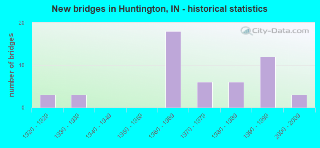
- New bridges - historical statistics
- 31920-1929
- 31930-1939
- 181960-1969
- 61970-1979
- 61980-1989
- 121990-1999
- 32000-2009
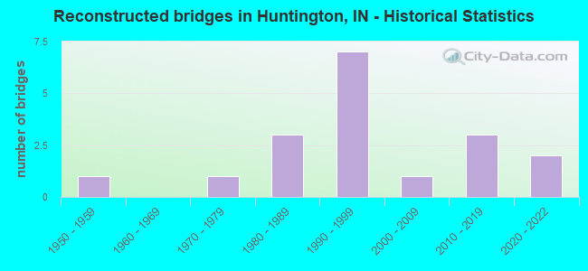
- Reconstructed bridges - Historical Statistics
- 11950-1959
- 01960-1969
- 11970-1979
- 31980-1989
- 71990-1999
- 12000-2009
- 32010-2019
- 22020-2022
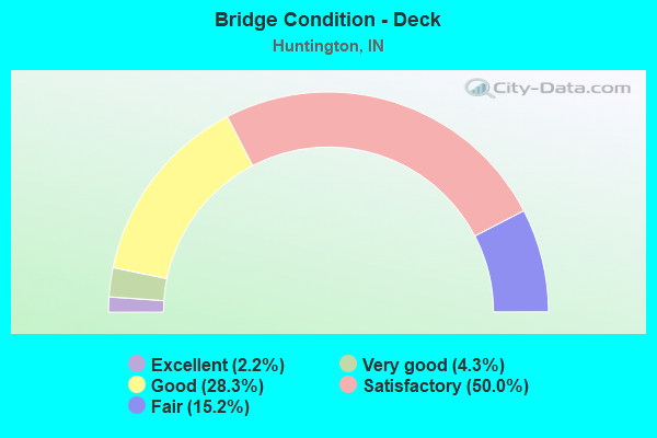
- Bridge Condition - Deck
- 2.2%Excellent
- 4.3%Very good
- 28.3%Good
- 50.0%Satisfactory
- 15.2%Fair
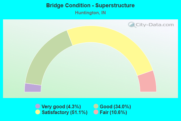
- Bridge Condition - Superstructure
- 4.3%Very good
- 34.0%Good
- 51.1%Satisfactory
- 10.6%Fair
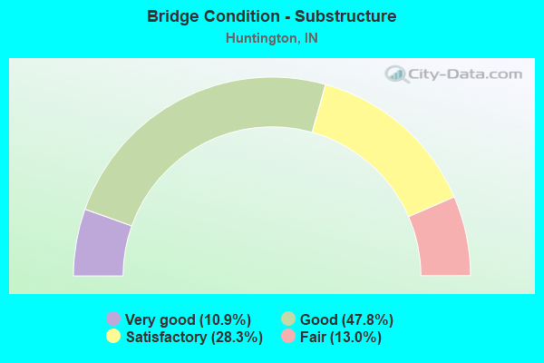
- Bridge Condition - Substructure
- 10.9%Very good
- 47.8%Good
- 28.3%Satisfactory
- 13.0%Fair
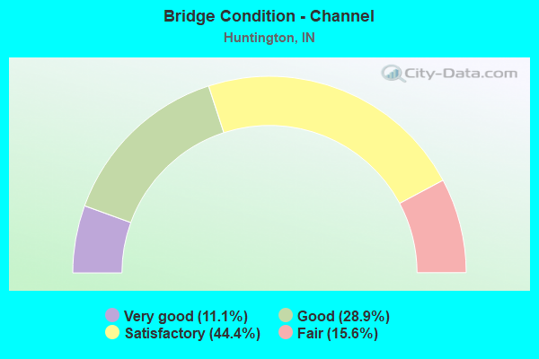
- Bridge Condition - Channel
- 11.1%Very good
- 28.9%Good
- 44.4%Satisfactory
- 15.6%Fair
Find on map >> Show street view
Structure Number: 3500111, Location: 0.05 MI E OF CR 200 N (Lat: 40.858150, Lng: -85.507539), Route carried "on" structure: City street , Year Built: 1975, Status: Open, Structure Length: 8.38m (27.49ft), Average Daily Traffic: 4,878 (year 2021), Truck Traffic: 5%, Average Future Daily Traffic: 7,504 (year 2041), Design Load: HS 20, Features Intersected: WABASH RIVER, Facility Carried by Structure: ETNA ROAD
Minimum Vertical Clearance: 30+ m (98+ ft), Kilometerpoint: 0.000, Lanes on structure: 2, Owner: County Highway Agency, Approaching Roadway Width: 6.7m (22.0ft), Navigation Control: Yes ( Vertical Clearance: 5.2m (17.1ft), Horizontal Clearance: 26.8m (87.9ft)), Material/Design: Prestressed concrete continuous, Design/Construction: Stringer/Multi-beam, Number Of Spans In Main Unit: 3, Length of Maximum Span: 27.7m (90.9ft), Curb or Sidewalk Widths: Left: 0.2m (0.7ft), Right: 1.5m (4.9ft), Curb-To-Curb Width: 9.1m (29.9ft), Out-to-Out Width: 11.6m (38.1ft)
Condition: Deck: Good, Superstructure: Good, Substructure: Good, Channel: Satisfactory, Operating Rating: 63.7 metric tons, Method Used To Determine Operating Rating: Load and Resistance Factor (LRFR), Inventory Rating: 32.9 metric tons, Method Used To Determine Inventory Rating: Load and Resistance Factor (LRFR), Structural Evaluation: Better than present minimum criteria, Deck Geometry: Meets minimum limits, Waterway Adequacy: Equal to present desirable criteria, Approach Roadway Alignment: High priority of corrective action, Designated Inspection Frequency: Every 24 months, Underwater Inspection Frequency: Every 60 months, Inspection Date: September 2021, Underwater Inspection Date: September 2017, Deck Structure Type: Concrete Cast-file-Place, Wearing Surface/Protective System: Wearing Surface: Monolithic Concrete
Find on map >> Show street view
Structure Number: 3500112, Location: 0.1 MI N OF SR 9 (Lat: 40.842150, Lng: -85.526589), Route carried "on" structure: City street , Year Built: 2001, Status: Open, Structure Length: 1.52m (4.99ft), Average Daily Traffic: 1,471 (year 2021), Truck Traffic: 5%, Average Future Daily Traffic: 2,207 (year 2041), Design Load: HS 20, Features Intersected: LOON CREEK, Facility Carried by Structure: ETNA ROAD
Minimum Vertical Clearance: 30+ m (98+ ft), Kilometerpoint: 0.000, Lanes on structure: 1, Owner: County Highway Agency, Approaching Roadway Width: 4.9m (16.1ft), Material/Design: Wood or Timber, Design/Construction: Slab, Number Of Spans In Main Unit: 3, Length of Maximum Span: 7.9m (25.9ft), Curb or Sidewalk Widths: Left: 0.2m (0.7ft), Right: 0.2m (0.7ft), Curb-To-Curb Width: 7.4m (24.3ft), Out-to-Out Width: 7.8m (25.6ft)
Condition: Deck: Satisfactory, Superstructure: Satisfactory, Substructure: Satisfactory, Channel: Satisfactory, Operating Rating: 67.4 metric tons, Method Used To Determine Operating Rating: Load and Resistance Factor (LRFR), Inventory Rating: 50.1 metric tons, Method Used To Determine Inventory Rating: Load and Resistance Factor (LRFR), Structural Evaluation: Equal to present minimum criteria, Deck Geometry: Meets minimum limits, Waterway Adequacy: Better than present minimum criteria, Approach Roadway Alignment: Equal to present desirable criteria, Designated Inspection Frequency: Every 24 months, Inspection Date: September 2021, Deck Structure Type: Wood or Timber, Wearing Surface/Protective System: Wearing Surface: Bituminous, Deck Protection: Internally Sealed
Find on map >> Show street view
Structure Number: 3500114, Location: 0.9 MI W OF RANGELINE RD (Lat: 40.877500, Lng: -85.552731), Route carried "on" structure: County highway , Year Built: 1995, Status: Open, Structure Length: 0.73m (2.40ft), Average Daily Traffic: 420 (year 2021), Truck Traffic: 2%, Average Future Daily Traffic: 551 (year 2041), Design Load: HS 20, Features Intersected: BRANCH WABASH RIVER, Facility Carried by Structure: RIVER ROAD
Minimum Vertical Clearance: 30+ m (98+ ft), Kilometerpoint: 0.000, Lanes on structure: 2, Owner: County Highway Agency, Approaching Roadway Width: 5.5m (18.0ft), Material/Design: Prestressed concrete, Design/Construction: Box Beam or Girders - Multiple, Number Of Spans In Main Unit: 1, Length of Maximum Span: 6.4m (21.0ft), Curb-To-Curb Width: 7.2m (23.6ft), Out-to-Out Width: 7.3m (24.0ft)
Condition: Deck: Good, Superstructure: Good, Substructure: Good, Channel: Satisfactory, Operating Rating: 32.7 metric tons, Method Used To Determine Operating Rating: Field evaluation and documented engineering judgment, Inventory Rating: 32.7 metric tons, Method Used To Determine Inventory Rating: Field evaluation and documented engineering judgment, Structural Evaluation: Better than present minimum criteria, Deck Geometry: Meets minimum limits, Waterway Adequacy: Somewhat better than minimum adequacy, Approach Roadway Alignment: Equal to present minimum criteria, Designated Inspection Frequency: Every 24 months, Inspection Date: September 2021, Deck Structure Type: Concrete Precast Panels, Wearing Surface/Protective System: Wearing Surface: Bituminous
Find on map >> Show street view
Structure Number: 3500119, Location: 0.2 MI S OF CR 800 N (Lat: 40.942469, Lng: -85.565769), Route carried "on" structure: County highway 19, Year Built: 1970, Year Reconstructed: 1990, Status: Open, Structure Length: 0.76m (2.49ft), Average Daily Traffic: 105 (year 2021), Truck Traffic: 2%, Average Future Daily Traffic: 157 (year 2041), Design Load: HS 20, Features Intersected: BRANCH CLEAR CREEK, Facility Carried by Structure: CR 600 WEST
Minimum Vertical Clearance: 30+ m (98+ ft), Kilometerpoint: 0.000, Lanes on structure: 2, Owner: County Highway Agency, Approaching Roadway Width: 5.5m (18.0ft), Material/Design: Prestressed concrete, Design/Construction: Box Beam or Girders - Multiple, Number Of Spans In Main Unit: 1, Length of Maximum Span: 7.3m (24.0ft), Curb-To-Curb Width: 7.2m (23.6ft), Out-to-Out Width: 7.3m (24.0ft)
Condition: Deck: Good, Superstructure: Good, Substructure: Fair, Channel: Satisfactory, Operating Rating: 49.1 metric tons, Method Used To Determine Operating Rating: Load and Resistance Factor (LRFR), Inventory Rating: 36.6 metric tons, Method Used To Determine Inventory Rating: Load and Resistance Factor (LRFR), Structural Evaluation: Somewhat better than minimum adequacy, Deck Geometry: Meets minimum limits, Waterway Adequacy: Better than present minimum criteria, Approach Roadway Alignment: Equal to present desirable criteria, Designated Inspection Frequency: Every 24 months, Inspection Date: September 2021, Deck Structure Type: Concrete Cast-file-Place, Wearing Surface/Protective System: Wearing Surface: Bituminous
Find on map >> Show street view
Structure Number: 3500124, Location: 0.1 MI E OF CLEAR CREEK R (Lat: 40.945800, Lng: -85.532500), Route carried "on" structure: County highway 70, Year Built: 1997, Status: Open, Structure Length: 0.79m (2.59ft), Average Daily Traffic: 262 (year 2021), Truck Traffic: 2%, Average Future Daily Traffic: 367 (year 2041), Design Load: HS 20, Features Intersected: BRANCH CLEAR CREEK, Facility Carried by Structure: CR 800 NORTH
Minimum Vertical Clearance: 30+ m (98+ ft), Kilometerpoint: 0.000, Lanes on structure: 2, Owner: County Highway Agency, Approaching Roadway Width: 6.1m (20.0ft), Skew: 1 degrees, Material/Design: Prestressed concrete, Design/Construction: Box Beam or Girders - Multiple, Number Of Spans In Main Unit: 1, Length of Maximum Span: 7.3m (24.0ft), Curb-To-Curb Width: 7.2m (23.6ft), Out-to-Out Width: 7.3m (24.0ft)
Condition: Deck: Good, Superstructure: Good, Substructure: Good, Channel: Satisfactory, Operating Rating: 32.7 metric tons, Method Used To Determine Operating Rating: Field evaluation and documented engineering judgment, Inventory Rating: 32.7 metric tons, Method Used To Determine Inventory Rating: Field evaluation and documented engineering judgment, Structural Evaluation: Better than present minimum criteria, Deck Geometry: Meets minimum limits, Waterway Adequacy: Better than present minimum criteria, Approach Roadway Alignment: Equal to present desirable criteria, Designated Inspection Frequency: Every 24 months, Inspection Date: September 2021, Deck Structure Type: Concrete Precast Panels, Wearing Surface/Protective System: Wearing Surface: Bituminous
Find on map >> Show street view
Structure Number: 3500131, Location: 1.8 MI N OF US 24 (Lat: 40.897639, Lng: -85.542519), Route carried "on" structure: County highway , Year Built: 1999, Status: Open, Structure Length: 0.80m (2.62ft), Average Daily Traffic: 367 (year 2021), Truck Traffic: 2%, Average Future Daily Traffic: 472 (year 2041), Design Load: HS 20, Features Intersected: BRANCH CLEAR CREEK, Facility Carried by Structure: RANGELINE ROAD
Minimum Vertical Clearance: 30+ m (98+ ft), Kilometerpoint: 0.000, Lanes on structure: 2, Owner: County Highway Agency, Approaching Roadway Width: 6.4m (21.0ft), Skew: 3 degrees, Material/Design: Wood or Timber, Design/Construction: Slab, Number Of Spans In Main Unit: 1, Length of Maximum Span: 7.7m (25.3ft), Curb or Sidewalk Widths: Left: 0.2m (0.7ft), Right: 0.2m (0.7ft), Curb-To-Curb Width: 9.2m (30.2ft), Out-to-Out Width: 9.7m (31.8ft)
Condition: Deck: Good, Superstructure: Good, Substructure: Satisfactory, Channel: Good, Operating Rating: 78.3 metric tons, Method Used To Determine Operating Rating: Load and Resistance Factor (LRFR), Inventory Rating: 58.2 metric tons, Method Used To Determine Inventory Rating: Load and Resistance Factor (LRFR), Structural Evaluation: Equal to present minimum criteria, Deck Geometry: Equal to present minimum criteria, Waterway Adequacy: Better than present minimum criteria, Approach Roadway Alignment: High priority of corrective action, Designated Inspection Frequency: Every 24 months, Inspection Date: September 2021, Deck Structure Type: Wood or Timber, Wearing Surface/Protective System: Wearing Surface: Bituminous, Deck Protection: Internally Sealed
Find on map >> Show street view
Structure Number: 3500133, Location: 0.3 MI N OF US 24 (Lat: 40.910500, Lng: -85.490700), Route carried "on" structure: County highway 41, Year Built: 1999, Status: Open, Structure Length: 1.22m (4.00ft), Average Daily Traffic: 183 (year 2021), Truck Traffic: 5%, Average Future Daily Traffic: 262 (year 2041), Design Load: HS 20, Features Intersected: FLINT CREEK, Facility Carried by Structure: CR 200 WEST
Minimum Vertical Clearance: 30+ m (98+ ft), Kilometerpoint: 0.000, Lanes on structure: 2, Owner: County Highway Agency, Approaching Roadway Width: 5.8m (19.0ft), Skew: 2 degrees, Material/Design: Prestressed concrete, Design/Construction: Box Beam or Girders - Multiple, Number Of Spans In Main Unit: 1, Length of Maximum Span: 11.1m (36.4ft), Curb-To-Curb Width: 7.3m (24.0ft), Out-to-Out Width: 7.4m (24.3ft)
Condition: Deck: Satisfactory, Superstructure: Satisfactory, Substructure: Good, Channel: Good, Operating Rating: 32.7 metric tons, Method Used To Determine Operating Rating: Field evaluation and documented engineering judgment, Inventory Rating: 32.7 metric tons, Method Used To Determine Inventory Rating: Field evaluation and documented engineering judgment, Structural Evaluation: Equal to present minimum criteria, Deck Geometry: Somewhat better than minimum adequacy, Waterway Adequacy: Better than present minimum criteria, Approach Roadway Alignment: Equal to present desirable criteria, Designated Inspection Frequency: Every 24 months, Inspection Date: September 2021, Deck Structure Type: Concrete Precast Panels, Wearing Surface/Protective System: Wearing Surface: Bituminous
Find on map >> Show street view
Structure Number: 148, Location: 1.21 MI S. OF US 224 (Lat: 40.846667, Lng: -85.470000), Route carried "on" structure: State highway 5, Year Built: 1965, Year Reconstructed: 2004, Status: Open, Structure Length: 4.72m (15.49ft), Average Daily Traffic: 4,015 (year 2019), Truck Traffic: 15%, Average Future Daily Traffic: 5,000 (year 2040), Design Load: HS 20+Mod, Features Intersected: WABASH RIVER, ROUSH LAKE
Minimum Vertical Clearance: 30+ m (98+ ft), Kilometerpoint: 45.468, Lanes on structure: 2, Owner: Corps of Engineers (Civil), Maintenance Responsibility: State Highway Agency, Approaching Roadway Width: 11.3m (37.1ft), Material/Design: Steel continuous, Design/Construction: Stringer/Multi-beam, Number Of Spans In Main Unit: 3, Length of Maximum Span: 13.7m (44.9ft), Curb or Sidewalk Widths: Left: 0.5m (1.6ft), Right: 0.8m (2.6ft), Curb-To-Curb Width: 10.0m (32.8ft), Out-to-Out Width: 11.3m (37.1ft)
Condition: Deck: Satisfactory, Superstructure: Good, Substructure: Good, Channel: Very good, Operating Rating: 89.7 metric tons, Method Used To Determine Operating Rating: Load Factor (LF), Inventory Rating: 50.9 metric tons, Method Used To Determine Inventory Rating: Load Factor (LF), Structural Evaluation: Better than present minimum criteria, Deck Geometry: Meets minimum limits, Waterway Adequacy: Equal to present desirable criteria, Approach Roadway Alignment: Better than present minimum criteria, Length Of Structure Improvement: 4.87m (15.98ft), Designated Inspection Frequency: Every 24 months, Inspection Date: September 2020, Bridge Improvement Cost: $83,000, Roadway Improvement Cost: $8,000, Total Project Cost: $125,000 ( Estimate for 2020), Deck Structure Type: Concrete Cast-file-Place, Wearing Surface/Protective System: Wearing Surface: Latex Concrete
Find on map >> Show street view
Structure Number: 273, Location: 03.55 N US 24 (Lat: 40.905119, Lng: -85.481378), Route carried "under" structure: US 24, Year Built: 1965, Structure Length: 0. m, Average Daily Traffic: 7,179 (year 2019), Truck Traffic: 16%, Features Intersected: US 24 EB, Facility Carried by Structure: SR 9
Minimum Vertical Clearance: 4.65m (15.26ft), Kilometerpoint: 16.367, Lanes on structure: 2, Lanes under structure: 4, Material/Design: Steel continuous, Design/Construction: Stringer/Multi-beam, Length of Maximum Span: 18.5m (60.7ft)
Find on map >> Show street view
Structure Number: 273, Location: 03.55 N US 24 (Lat: 40.905119, Lng: -85.481378), Route carried "under" structure: US 24, Year Built: 1965, Structure Length: 0. m, Average Daily Traffic: 7,179 (year 2019), Truck Traffic: 16%, Features Intersected: US 24 WB, Facility Carried by Structure: SR 9
Minimum Vertical Clearance: 4.56m (14.96ft), Kilometerpoint: 16.367, Lanes on structure: 2, Lanes under structure: 4, Material/Design: Steel continuous, Design/Construction: Stringer/Multi-beam, Length of Maximum Span: 18.5m (60.7ft)
Find on map >> Show street view
Structure Number: 612, Location: 01.20 E SR 9 (Lat: 40.898431, Lng: -85.460556), Route carried "under" structure: County highway , Year Built: 1964, Structure Length: 0. m, Average Daily Traffic: 6,034 (year 2020), Truck Traffic: 15%, Features Intersected: US 24 EB, Facility Carried by Structure: OLD US 24 WB
Minimum Vertical Clearance: 4.80m (15.75ft), Kilometerpoint: 18.298, Lanes on structure: 2, Lanes under structure: 2, Material/Design: Steel continuous, Design/Construction: Stringer/Multi-beam, Length of Maximum Span: 20.1m (65.9ft)