Bridge Statistics for Irondale, Alabama (AL)
Condition, Traffic, Stress, Structural Evaluation, Project Costs
- National Bridge Inventory (NBI) Statistics
- 53Number of bridges
- 1,020ft / 311mTotal length
- $151,398,000Total costs
- 1,544,010Total average daily traffic
- 235,940Total average daily truck traffic
- National Bridge Inventory (NBI) Registered Bridges for Irondale
- No street view available for this location
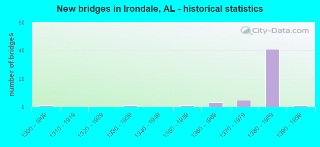
- New bridges - historical statistics
- 11900-1909
- 11930-1939
- 11950-1959
- 31960-1969
- 51970-1979
- 411980-1989
- 11990-1999
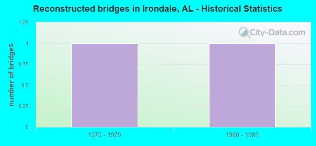
- Reconstructed bridges - Historical Statistics
- 11970-1979
- 11980-1989
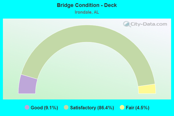
- Bridge Condition - Deck
- 9.1%Good
- 86.4%Satisfactory
- 4.5%Fair
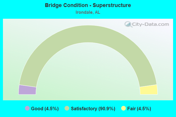
- Bridge Condition - Superstructure
- 4.5%Good
- 90.9%Satisfactory
- 4.5%Fair
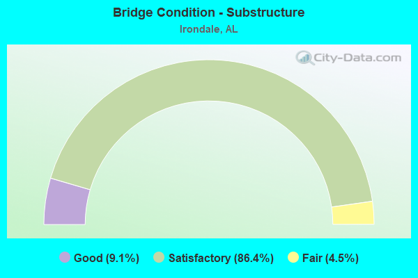
- Bridge Condition - Substructure
- 9.1%Good
- 86.4%Satisfactory
- 4.5%Fair
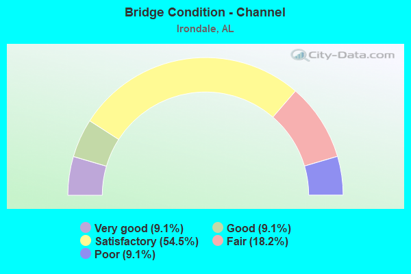
- Bridge Condition - Channel
- 9.1%Very good
- 9.1%Good
- 54.5%Satisfactory
- 18.2%Fair
- 9.1%Poor
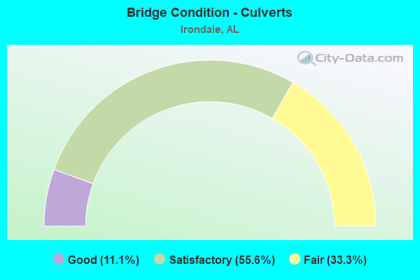
- Bridge Condition - Culverts
- 11.1%Good
- 55.6%Satisfactory
- 33.3%Fair
Find on map >> Show street view
Structure Number: 1317, Location: JCT FINLEY DR * DRYBRANCH (Lat: 34.610200, Lng: -86.992800), Route carried "on" structure: City street , Year Built: 1935, Status: Open, Structure Length: 1.13m (3.71ft), Average Daily Traffic: 13,834 (year 2009), Truck Traffic: 20%, Average Future Daily Traffic: 18,834 (year 2030), Design Load: H 15, Features Intersected: DRY BRANCH, Facility Carried by Structure: FINLEY DR NW
Minimum Vertical Clearance: 30+ m (98+ ft), Kilometerpoint: 0.010, Lanes on structure: 2, Owner: City or Municipal Highway Agency, Approaching Roadway Width: 6.1m (20.0ft), Material/Design: Concrete, Design/Construction: Culvert, Number Of Spans In Main Unit: 1, Length of Maximum Span: 11.3m (37.1ft), Curb or Sidewalk Widths: Left: 1.4m (4.6ft), Right: 1.4m (4.6ft), Curb-To-Curb Width: 6.1m (20.0ft), Out-to-Out Width: 9.4m (30.8ft)
Condition: Channel: Satisfactory, Culverts: Fair, Operating Rating: 32.7 metric tons, Method Used To Determine Operating Rating: Field evaluation and documented engineering judgment, Inventory Rating: 23.6 metric tons, Method Used To Determine Inventory Rating: Field evaluation and documented engineering judgment, Structural Evaluation: Somewhat better than minimum adequacy, Deck Geometry: High priority of replacement, Waterway Adequacy: Equal to present minimum criteria, Approach Roadway Alignment: Better than present minimum criteria, Length Of Structure Improvement: 1.81m (5.94ft), Designated Inspection Frequency: Every 24 months, Underwater Inspection Frequency: Every 48 months, Inspection Date: August 2021, Underwater Inspection Date: August 2019, Bridge Improvement Cost: $313,000, Roadway Improvement Cost: $31,000, Total Project Cost: $344,000 ( Estimate for 2022), Deck Structure Type: Concrete Cast-file-Place, Wearing Surface/Protective System: Wearing Surface: Bituminous
Find on map >> Show street view
Structure Number: 715, Location: AT GRANTS MILL (Lat: 33.510900, Lng: -86.652550), Route carried "on" structure: County highway 143, Year Built: 1960, Status: Posted for load, Structure Length: 10.42m (34.19ft), Average Daily Traffic: 7,105 (year 2021), Truck Traffic: 10%, Average Future Daily Traffic: 9,900 (year 2041), Design Load: H 15, Features Intersected: CAHABA RIVER, Facility Carried by Structure: GRANTS MILL ROAD
Minimum Vertical Clearance: 30+ m (98+ ft), Kilometerpoint: 0.010, Lanes on structure: 2, Owner: County Highway Agency, Approaching Roadway Width: 7.2m (23.6ft), Material/Design: Steel continuous, Design/Construction: Stringer/Multi-beam, Number Of Spans In Main Unit: 3, Number Of Approach Spans: 2, Length of Maximum Span: 30.5m (100.1ft), Curb or Sidewalk Widths: Left: 0.5m (1.6ft), Right: 0.5m (1.6ft), Curb-To-Curb Width: 7.3m (24.0ft), Out-to-Out Width: 8.9m (29.2ft)
Condition: Deck: Satisfactory, Superstructure: Good, Substructure: Good, Channel: Satisfactory, Operating Rating: 34.4 metric tons, Method Used To Determine Operating Rating: Load Factor (LF), Inventory Rating: 20.6 metric tons, Method Used To Determine Inventory Rating: Load Factor (LF), Structural Evaluation: Somewhat better than minimum adequacy, Deck Geometry: High priority of replacement, Waterway Adequacy: Better than present minimum criteria, Approach Roadway Alignment: Better than present minimum criteria, Bridge Posting: Required (Relationship of Operating Rating to Maximum Legal Load: 10.0 - 19.9% below), Length Of Structure Improvement: 11.34m (37.20ft), Designated Inspection Frequency: Every 24 months, Other Special Inspection Frequency: Every 12 months, Inspection Date: July 2021, Other Special Inspection Date: July 2021, Bridge Improvement Cost: $2,254,000, Roadway Improvement Cost: $225,000, Total Project Cost: $2,479,000 ( Estimate for 2022), Deck Structure Type: Concrete Cast-file-Place
Find on map >> Show street view
Structure Number: 8853, Location: 1.5 MI N US 78 (Lat: 33.562517, Lng: -86.651900), Route carried "on" structure: County highway 100, Year Built: 1965, Status: Posted for load, Structure Length: 6.04m (19.82ft), Average Daily Traffic: 1,582 (year 2021), Truck Traffic: 22%, Average Future Daily Traffic: 2,100 (year 2041), Design Load: H 20, Features Intersected: NORFOLK SOUTHERN RR, Facility Carried by Structure: ALTON ROAD
Minimum Vertical Clearance: 30+ m (98+ ft), Kilometerpoint: 0.010, Lanes on structure: 2, Owner: County Highway Agency, Approaching Roadway Width: 6.5m (21.3ft), Skew: 4 degrees, Material/Design: Steel, Design/Construction: Stringer/Multi-beam, Number Of Spans In Main Unit: 1, Number Of Approach Spans: 4, Length of Maximum Span: 20.1m (65.9ft), Curb or Sidewalk Widths: Left: 0.5m (1.6ft), Right: 0.5m (1.6ft), Curb-To-Curb Width: 7.8m (25.6ft), Out-to-Out Width: 9.5m (31.2ft)
Condition: Deck: Fair, Superstructure: Satisfactory, Substructure: Satisfactory, Operating Rating: 34.6 metric tons, Method Used To Determine Operating Rating: Load Factor (LF), Inventory Rating: 20.8 metric tons, Method Used To Determine Inventory Rating: Load Factor (LF), Structural Evaluation: Somewhat better than minimum adequacy, Deck Geometry: Meets minimum limits, Underclear: Somewhat better than minimum adequacy, Approach Roadway Alignment: Equal to present minimum criteria, Bridge Posting: Required (Relationship of Operating Rating to Maximum Legal Load: 0.1 - 9.9% below), Length Of Structure Improvement: 7.07m (23.20ft), Designated Inspection Frequency: Every 24 months, Other Special Inspection Frequency: Every 12 months, Inspection Date: October 2021, Other Special Inspection Date: October 2021, Bridge Improvement Cost: $1,504,000, Roadway Improvement Cost: $150,000, Total Project Cost: $1,654,000 ( Estimate for 2022), Deck Structure Type: Concrete Cast-file-Place
Find on map >> Show street view
Structure Number: 9737, Location: 5 TH AVE S. NEAR 28TH ST (Lat: 33.540600, Lng: -86.695600), Route carried "on" structure: City street , Year Built: 1968, Status: Open, Structure Length: 1.52m (4.99ft), Average Daily Traffic: 500 (year 2020), Truck Traffic: 10%, Average Future Daily Traffic: 750 (year 2040), Design Load: H 15, Features Intersected: SHADES CK, Facility Carried by Structure: 5TH AVENUE SOUTH
Minimum Vertical Clearance: 30+ m (98+ ft), Kilometerpoint: 0.698, Lanes on structure: 2, Owner: City or Municipal Highway Agency, Approaching Roadway Width: 7.3m (24.0ft), Material/Design: Concrete, Design/Construction: Culvert, Number Of Spans In Main Unit: 5, Length of Maximum Span: 3.0m (9.8ft)
Condition: Channel: Satisfactory, Culverts: Satisfactory, Operating Rating: 41.4 metric tons, Method Used To Determine Operating Rating: Load Factor (LF), Inventory Rating: 24.8 metric tons, Method Used To Determine Inventory Rating: Load Factor (LF), Structural Evaluation: Equal to present minimum criteria, Waterway Adequacy: Equal to present minimum criteria, Approach Roadway Alignment: Equal to present minimum criteria, Length Of Structure Improvement: 2.20m (7.22ft), Designated Inspection Frequency: Every 24 months, Inspection Date: July 2020, Bridge Improvement Cost: $509,000, Roadway Improvement Cost: $51,000, Total Project Cost: $560,000 ( Estimate for 2022)
Find on map >> Show street view
Structure Number: 10763, Location: US 78 * 25TH ST SO. (Lat: 33.558333, Lng: -86.683333), Route carried "on" structure: City street , Year Built: 1972, Status: Open, Structure Length: 1.62m (5.31ft), Average Daily Traffic: 2,500 (year 2020), Truck Traffic: 5%, Average Future Daily Traffic: 3,500 (year 2040), Design Load: H 15, Features Intersected: SHADES CREEK, Facility Carried by Structure: 25TH ST SO.
Minimum Vertical Clearance: 30+ m (98+ ft), Kilometerpoint: 0.100, Lanes on structure: 2, Owner: City or Municipal Highway Agency, Approaching Roadway Width: 7.6m (24.9ft), Material/Design: Concrete, Design/Construction: Culvert, Number Of Spans In Main Unit: 5, Length of Maximum Span: 3.0m (9.8ft), Curb-To-Curb Width: 14.9m (48.9ft), Out-to-Out Width: 15.4m (50.5ft)
Condition: Channel: Poor, Culverts: Satisfactory, Operating Rating: 49.8 metric tons, Method Used To Determine Operating Rating: Load Factor (LF), Inventory Rating: 29.8 metric tons, Method Used To Determine Inventory Rating: Load Factor (LF), Structural Evaluation: Equal to present minimum criteria, Deck Geometry: Superior to present desirable criteria, Waterway Adequacy: Equal to present minimum criteria, Approach Roadway Alignment: Equal to present desirable criteria, Length Of Structure Improvement: 2.30m (7.55ft), Designated Inspection Frequency: Every 24 months, Inspection Date: July 2020, Bridge Improvement Cost: $531,000, Roadway Improvement Cost: $53,000, Total Project Cost: $584,000 ( Estimate for 2022)
Find on map >> Show street view
Structure Number: 11252, Location: 5 TH AV S * COMMERCE BLVD (Lat: 33.544783, Lng: -86.691822), Route carried "on" structure: City street , Year Built: 1974, Status: Open, Structure Length: 1.52m (4.99ft), Average Daily Traffic: 2,500 (year 2020), Truck Traffic: 20%, Average Future Daily Traffic: 3,000 (year 2040), Design Load: H 15, Features Intersected: SHADES CK, Facility Carried by Structure: COMMERCE BLVD
Minimum Vertical Clearance: 30+ m (98+ ft), Kilometerpoint: 0.800, Lanes on structure: 2, Owner: City or Municipal Highway Agency, Approaching Roadway Width: 7.3m (24.0ft), Skew: 3 degrees, Material/Design: Concrete, Design/Construction: Culvert, Number Of Spans In Main Unit: 5, Length of Maximum Span: 3.0m (9.8ft)
Condition: Channel: Satisfactory, Culverts: Fair, Operating Rating: 52.7 metric tons, Method Used To Determine Operating Rating: Load Factor (LF), Inventory Rating: 31.6 metric tons, Method Used To Determine Inventory Rating: Load Factor (LF), Structural Evaluation: Somewhat better than minimum adequacy, Waterway Adequacy: Equal to present desirable criteria, Approach Roadway Alignment: Equal to present minimum criteria, Length Of Structure Improvement: 2.20m (7.22ft), Designated Inspection Frequency: Every 24 months, Inspection Date: July 2020, Bridge Improvement Cost: $866,000, Roadway Improvement Cost: $87,000, Total Project Cost: $953,000 ( Estimate for 2022)
Find on map >> Show street view
Structure Number: 12098, Location: .5 MI SO AMBER HILLS RD (Lat: 33.559900, Lng: -86.639900), Route carried "on" structure: Interstate 459, Year Built: 1979, Status: Open, Structure Length: 1.04m (3.41ft), Average Daily Traffic: 58,910 (year 2020), Truck Traffic: 12%, Average Future Daily Traffic: 74,487 (year 2040), Design Load: HS 20, Features Intersected: STREAM
Minimum Vertical Clearance: 30+ m (98+ ft), Kilometerpoint: 48.803, Lanes on structure: 6, Base Highway Network: Yes, Owner: State Highway Agency, Approaching Roadway Width: 37.8m (124.0ft), Material/Design: Concrete, Design/Construction: Culvert, Number Of Spans In Main Unit: 3, Length of Maximum Span: 3.0m (9.8ft)
Condition: Channel: Fair, Culverts: Fair, Operating Rating: 88.9 metric tons, Method Used To Determine Operating Rating: Load Factor (LF), Inventory Rating: 88.9 metric tons, Method Used To Determine Inventory Rating: Load Factor (LF), Structural Evaluation: Somewhat better than minimum adequacy, Waterway Adequacy: Equal to present minimum criteria, Approach Roadway Alignment: Equal to present desirable criteria, Length Of Structure Improvement: 1.71m (5.61ft), Designated Inspection Frequency: Every 24 months, Inspection Date: November 2020, Bridge Improvement Cost: $4,437,000, Roadway Improvement Cost: $444,000, Total Project Cost: $4,881,000 ( Estimate for 2022)
Find on map >> Show street view
Structure Number: 12099, Location: I459 * AMBER HILLS ROAD (Lat: 33.567564, Lng: -86.638453), Route carried "on" structure: City street , Year Built: 1979, Status: Open, Structure Length: 10.00m (32.81ft), Average Daily Traffic: 1,200 (year 2021), Truck Traffic: 1%, Average Future Daily Traffic: 1,600 (year 2041), Design Load: HS 20, Features Intersected: I - 459, Facility Carried by Structure: AMBER HILLS ROAD
Minimum Vertical Clearance: 30+ m (98+ ft), Kilometerpoint: 0.010, Lanes on structure: 2, Lanes under structure: 6, Owner: State Highway Agency, Approaching Roadway Width: 13.4m (44.0ft), Skew: 4 degrees, Material/Design: Steel continuous, Design/Construction: Stringer/Multi-beam, Number Of Spans In Main Unit: 2, Number Of Approach Spans: 2, Length of Maximum Span: 32.0m (105.0ft), Curb-To-Curb Width: 10.4m (34.1ft), Out-to-Out Width: 11.1m (36.4ft)
Condition: Deck: Good, Superstructure: Satisfactory, Substructure: Satisfactory, Operating Rating: 46.1 metric tons, Method Used To Determine Operating Rating: Load Factor (LF), Inventory Rating: 27.4 metric tons, Method Used To Determine Inventory Rating: Load Factor (LF), Structural Evaluation: Equal to present minimum criteria, Deck Geometry: Equal to present minimum criteria, Underclear: Equal to present minimum criteria, Approach Roadway Alignment: Better than present minimum criteria, Length Of Structure Improvement: 10.93m (35.86ft), Designated Inspection Frequency: Every 24 months, Inspection Date: March 2021, Bridge Improvement Cost: $2,698,000, Roadway Improvement Cost: $270,000, Total Project Cost: $2,968,000 ( Estimate for 2022), Deck Structure Type: Concrete Cast-file-Place
Find on map >> Show street view
Structure Number: 12307, Location: I-459 * GRANTS MILL RD (Lat: 33.524222, Lng: -86.664164), Route carried "on" structure: City street , Year Built: 1980, Status: Open, Structure Length: 11.08m (36.35ft), Average Daily Traffic: 1,500 (year 2020), Truck Traffic: 1%, Average Future Daily Traffic: 2,500 (year 2040), Design Load: HS 20, Features Intersected: I-459, Facility Carried by Structure: GRANTS MILL RD
Minimum Vertical Clearance: 30+ m (98+ ft), Kilometerpoint: 0.014, Lanes on structure: 6, Lanes under structure: 6, Owner: State Highway Agency, Approaching Roadway Width: 18.3m (60.0ft), Material/Design: Steel continuous, Design/Construction: Stringer/Multi-beam, Number Of Spans In Main Unit: 4, Length of Maximum Span: 30.5m (100.1ft), Curb-To-Curb Width: 32.3m (106.0ft), Out-to-Out Width: 33.8m (110.9ft)
Condition: Deck: Satisfactory, Superstructure: Satisfactory, Substructure: Satisfactory, Operating Rating: 55.6 metric tons, Method Used To Determine Operating Rating: Load Factor (LF), Inventory Rating: 33.3 metric tons, Method Used To Determine Inventory Rating: Load Factor (LF), Structural Evaluation: Equal to present minimum criteria, Deck Geometry: Superior to present desirable criteria, Underclear: Equal to present minimum criteria, Approach Roadway Alignment: Equal to present desirable criteria, Length Of Structure Improvement: 11.97m (39.27ft), Designated Inspection Frequency: Every 24 months, Inspection Date: November 2020, Bridge Improvement Cost: $9,108,000, Roadway Improvement Cost: $911,000, Total Project Cost: $10,019,000 ( Estimate for 2022), Deck Structure Type: Concrete Cast-file-Place
Find on map >> Show street view
Structure Number: 125, Location: I459 * NORFOLK SOUTHERN (Lat: 33.558617, Lng: -86.640367), Route carried "on" structure: Interstate 459, Year Built: 1981, Status: Open, Structure Length: 6.79m (22.28ft), Average Daily Traffic: 29,455 (year 2021), Truck Traffic: 12%, Average Future Daily Traffic: 37,243 (year 2041), Design Load: HS 20, Features Intersected: NORFOLK SOUTHERN
Minimum Vertical Clearance: 30+ m (98+ ft), Kilometerpoint: 48.642, Lanes on structure: 3, Base Highway Network: Yes, Owner: State Highway Agency, Approaching Roadway Width: 18.9m (62.0ft), Skew: 1 degrees, Material/Design: Steel continuous, Design/Construction: Stringer/Multi-beam, Number Of Spans In Main Unit: 3, Length of Maximum Span: 25.6m (84.0ft), Curb-To-Curb Width: 17.1m (56.1ft), Out-to-Out Width: 17.9m (58.7ft)
Condition: Deck: Satisfactory, Superstructure: Satisfactory, Substructure: Satisfactory, Operating Rating: 54.6 metric tons, Method Used To Determine Operating Rating: Load Factor (LF), Inventory Rating: 32.7 metric tons, Method Used To Determine Inventory Rating: Load Factor (LF), Structural Evaluation: Equal to present minimum criteria, Deck Geometry: Equal to present minimum criteria, Underclear: Meets minimum limits, Approach Roadway Alignment: Equal to present desirable criteria, Length Of Structure Improvement: 7.82m (25.66ft), Designated Inspection Frequency: Every 24 months, Inspection Date: May 2021, Bridge Improvement Cost: $3,111,000, Roadway Improvement Cost: $311,000, Total Project Cost: $3,422,000 ( Estimate for 2022), Deck Structure Type: Concrete Cast-file-Place
Find on map >> Show street view
Structure Number: 12502, Location: I20 * SHADES CREEK (Lat: 33.530278, Lng: -86.705000), Route carried "on" structure: Interstate 20, Year Built: 1981, Status: Open, Structure Length: 1.71m (5.61ft), Average Daily Traffic: 55,750 (year 2020), Truck Traffic: 16%, Average Future Daily Traffic: 67,355 (year 2040), Design Load: HS 20, Features Intersected: SHADES CREEK
Minimum Vertical Clearance: 30+ m (98+ ft), Kilometerpoint: 214.337, Lanes on structure: 7, Base Highway Network: Yes, Owner: State Highway Agency, Approaching Roadway Width: 33.5m (109.9ft), Skew: 2 degrees, Material/Design: Concrete, Design/Construction: Culvert, Number Of Spans In Main Unit: 5, Length of Maximum Span: 3.0m (9.8ft)
Condition: Channel: Satisfactory, Culverts: Satisfactory, Operating Rating: 88.9 metric tons, Method Used To Determine Operating Rating: Load Factor (LF), Inventory Rating: 88.9 metric tons, Method Used To Determine Inventory Rating: Load Factor (LF), Structural Evaluation: Equal to present minimum criteria, Waterway Adequacy: Equal to present minimum criteria, Approach Roadway Alignment: Equal to present desirable criteria, Length Of Structure Improvement: 2.40m (7.87ft), Designated Inspection Frequency: Every 24 months, Inspection Date: October 2020, Bridge Improvement Cost: $5,299,000, Roadway Improvement Cost: $530,000, Total Project Cost: $5,829,000 ( Estimate for 2022), Wearing Surface/Protective System: Wearing Surface: Bituminous
Find on map >> Show street view
Structure Number: 12503, Location: I20 * KILGORE MEMORIAL DR (Lat: 33.533200, Lng: -86.698600), Route carried "on" structure: Spur Interstate 20, Year Built: 1981, Status: Open, Structure Length: 11.57m (37.96ft), Average Daily Traffic: 23,405 (year 2020), Truck Traffic: 17%, Average Future Daily Traffic: 28,277 (year 2040), Design Load: HS 20, Features Intersected: KILGORE MEMORIAL DR
Minimum Vertical Clearance: 30+ m (98+ ft), Kilometerpoint: 215.029, Lanes on structure: 4, Lanes under structure: 5, Base Highway Network: Yes, Owner: State Highway Agency, Approaching Roadway Width: 18.9m (62.0ft), Skew: 2 degrees, Material/Design: Steel continuous, Design/Construction: Stringer/Multi-beam, Number Of Spans In Main Unit: 3, Number Of Approach Spans: 1, Length of Maximum Span: 36.3m (119.1ft), Curb-To-Curb Width: 20.7m (67.9ft), Out-to-Out Width: 21.6m (70.9ft)
Condition: Deck: Satisfactory, Superstructure: Satisfactory, Substructure: Satisfactory, Operating Rating: 61.2 metric tons, Method Used To Determine Operating Rating: Load Factor (LF), Inventory Rating: 36.7 metric tons, Method Used To Determine Inventory Rating: Load Factor (LF), Structural Evaluation: Equal to present minimum criteria, Deck Geometry: Equal to present minimum criteria, Underclear: Superior to present desirable criteria, Approach Roadway Alignment: Equal to present desirable criteria, Length Of Structure Improvement: 12.44m (40.81ft), Designated Inspection Frequency: Every 24 months, Inspection Date: July 2020, Bridge Improvement Cost: $5,971,000, Roadway Improvement Cost: $597,000, Total Project Cost: $6,568,000 ( Estimate for 2022), Deck Structure Type: Concrete Cast-file-Place
Find on map >> Show street view
Structure Number: 12504, Location: I20 * KILGORE MEMORIAL DR (Lat: 33.533056, Lng: -86.698333), Route carried "on" structure: Interstate 20, Year Built: 1981, Status: Open, Structure Length: 11.11m (36.45ft), Average Daily Traffic: 23,405 (year 2020), Truck Traffic: 17%, Average Future Daily Traffic: 28,277 (year 2040), Design Load: HS 20, Features Intersected: KILGORE MEMORIAL DR
Minimum Vertical Clearance: 30+ m (98+ ft), Kilometerpoint: 215.029, Lanes on structure: 3, Lanes under structure: 4, Base Highway Network: Yes, Owner: State Highway Agency, Approaching Roadway Width: 18.9m (62.0ft), Skew: 2 degrees, Material/Design: Steel continuous, Design/Construction: Stringer/Multi-beam, Number Of Spans In Main Unit: 3, Number Of Approach Spans: 1, Length of Maximum Span: 31.7m (104.0ft), Curb-To-Curb Width: 17.1m (56.1ft), Out-to-Out Width: 17.5m (57.4ft)
Condition: Deck: Satisfactory, Superstructure: Satisfactory, Substructure: Satisfactory, Operating Rating: 61.3 metric tons, Method Used To Determine Operating Rating: Load Factor (LF), Inventory Rating: 36.7 metric tons, Method Used To Determine Inventory Rating: Load Factor (LF), Structural Evaluation: Equal to present minimum criteria, Deck Geometry: Equal to present minimum criteria, Underclear: Superior to present desirable criteria, Approach Roadway Alignment: Equal to present desirable criteria, Length Of Structure Improvement: 12.00m (39.37ft), Designated Inspection Frequency: Every 24 months, Inspection Date: July 2020, Bridge Improvement Cost: $4,688,000, Roadway Improvement Cost: $469,000, Total Project Cost: $5,157,000 ( Estimate for 2022), Deck Structure Type: Concrete Cast-file-Place
Find on map >> Show street view
Structure Number: 12505, Location: OLD LEEDS RD * I20 (Lat: 33.546600, Lng: -86.659900), Route carried "on" structure: County highway , Year Built: 1981, Status: Open, Structure Length: 9.51m (31.20ft), Average Daily Traffic: 1,800 (year 2020), Truck Traffic: 3%, Average Future Daily Traffic: 2,600 (year 2040), Design Load: HS 20, Features Intersected: I - 20, Facility Carried by Structure: OLD LEEDS RD
Minimum Vertical Clearance: 30+ m (98+ ft), Kilometerpoint: 0.010, Lanes on structure: 4, Lanes under structure: 6, Owner: State Highway Agency, Approaching Roadway Width: 21.9m (71.9ft), Material/Design: Steel continuous, Design/Construction: Stringer/Multi-beam, Number Of Spans In Main Unit: 4, Length of Maximum Span: 27.4m (89.9ft), Curb-To-Curb Width: 26.8m (87.9ft), Out-to-Out Width: 27.7m (90.9ft)
Condition: Deck: Satisfactory, Superstructure: Satisfactory, Substructure: Satisfactory, Operating Rating: 50.9 metric tons, Method Used To Determine Operating Rating: Load Factor (LF), Inventory Rating: 30.5 metric tons, Method Used To Determine Inventory Rating: Load Factor (LF), Structural Evaluation: Equal to present minimum criteria, Deck Geometry: Superior to present desirable criteria, Underclear: Equal to present minimum criteria, Approach Roadway Alignment: Equal to present minimum criteria, Length Of Structure Improvement: 10.46m (34.32ft), Designated Inspection Frequency: Every 24 months, Inspection Date: December 2020, Bridge Improvement Cost: $6,527,000, Roadway Improvement Cost: $653,000, Total Project Cost: $7,180,000 ( Estimate for 2022), Deck Structure Type: Concrete Cast-file-Place
Find on map >> Show street view
Structure Number: 12538, Location: US 78 * I459 (Lat: 33.548617, Lng: -86.643200), Route carried "on" structure: US 78, Year Built: 1981, Status: Open, Structure Length: 17.74m (58.20ft), Average Daily Traffic: 4,400 (year 2021), Truck Traffic: 5%, Average Future Daily Traffic: 5,674 (year 2041), Design Load: HS 20, Features Intersected: I 459 & I - 20 RAMPS, Facility Carried by Structure: AL - 4 WEST
Minimum Vertical Clearance: 30+ m (98+ ft), Kilometerpoint: 175.325, Lanes on structure: 2, Lanes under structure: 10, Owner: State Highway Agency, Approaching Roadway Width: 11.0m (36.1ft), Skew: 1 degrees, Material/Design: Steel continuous, Design/Construction: Stringer/Multi-beam, Number Of Spans In Main Unit: 4, Length of Maximum Span: 53.3m (174.9ft), Curb-To-Curb Width: 12.2m (40.0ft), Out-to-Out Width: 13.6m (44.6ft)
Condition: Deck: Satisfactory, Superstructure: Satisfactory, Substructure: Satisfactory, Operating Rating: 52.5 metric tons, Method Used To Determine Operating Rating: Load Factor (LF), Inventory Rating: 31.5 metric tons, Method Used To Determine Inventory Rating: Load Factor (LF), Structural Evaluation: Equal to present minimum criteria, Deck Geometry: Better than present minimum criteria, Underclear: Equal to present minimum criteria, Approach Roadway Alignment: Equal to present desirable criteria, Length Of Structure Improvement: 18.43m (60.47ft), Designated Inspection Frequency: Every 24 months, Inspection Date: July 2021, Bridge Improvement Cost: $5,561,000, Roadway Improvement Cost: $556,000, Total Project Cost: $6,117,000 ( Estimate for 2022), Deck Structure Type: Concrete Cast-file-Place
Find on map >> Show street view
Structure Number: 12539, Location: US 78 * I459 (Lat: 33.548617, Lng: -86.643200), Route carried "on" structure: US 78, Year Built: 1981, Status: Open, Structure Length: 17.74m (58.20ft), Average Daily Traffic: 4,400 (year 2021), Truck Traffic: 5%, Average Future Daily Traffic: 5,674 (year 2041), Design Load: HS 20, Features Intersected: I459 / I - 20 RAMPS, Facility Carried by Structure: AL - 4 EAST
Minimum Vertical Clearance: 30+ m (98+ ft), Kilometerpoint: 175.325, Lanes on structure: 2, Lanes under structure: 10, Owner: State Highway Agency, Approaching Roadway Width: 11.3m (37.1ft), Skew: 1 degrees, Material/Design: Steel continuous, Design/Construction: Stringer/Multi-beam, Number Of Spans In Main Unit: 4, Length of Maximum Span: 53.3m (174.9ft), Curb-To-Curb Width: 12.2m (40.0ft), Out-to-Out Width: 13.3m (43.6ft)
Condition: Deck: Satisfactory, Superstructure: Satisfactory, Substructure: Satisfactory, Operating Rating: 47.3 metric tons, Method Used To Determine Operating Rating: Load Factor (LF), Inventory Rating: 28.3 metric tons, Method Used To Determine Inventory Rating: Load Factor (LF), Structural Evaluation: Equal to present minimum criteria, Deck Geometry: Better than present minimum criteria, Underclear: Equal to present minimum criteria, Approach Roadway Alignment: Equal to present desirable criteria, Length Of Structure Improvement: 18.43m (60.47ft), Designated Inspection Frequency: Every 24 months, Inspection Date: July 2021, Bridge Improvement Cost: $5,435,000, Roadway Improvement Cost: $544,000, Total Project Cost: $5,979,000 ( Estimate for 2022), Deck Structure Type: Concrete Cast-file-Place
Find on map >> Show street view
Structure Number: 12677, Location: KILGORE MEM. DRIVE (Lat: 33.534683, Lng: -86.699550), Route carried "on" structure: US 78, Year Built: 1955, Year Reconstructed: 1982, Status: Open, Structure Length: 1.71m (5.61ft), Average Daily Traffic: 10,930 (year 2020), Truck Traffic: 5%, Average Future Daily Traffic: 14,096 (year 2040), Design Load: HS 20, Features Intersected: SHADES CREEK
Minimum Vertical Clearance: 30+ m (98+ ft), Kilometerpoint: 169.408, Lanes on structure: 4, Owner: State Highway Agency, Approaching Roadway Width: 12.8m (42.0ft), Skew: 3 degrees, Material/Design: Concrete, Design/Construction: Culvert, Number Of Spans In Main Unit: 5, Length of Maximum Span: 3.0m (9.8ft)
Condition: Channel: Very good, Culverts: Satisfactory, Operating Rating: 36.8 metric tons, Method Used To Determine Operating Rating: Load Factor (LF), Inventory Rating: 22.0 metric tons, Method Used To Determine Inventory Rating: Load Factor (LF), Structural Evaluation: Somewhat better than minimum adequacy, Waterway Adequacy: Equal to present desirable criteria, Approach Roadway Alignment: Equal to present desirable criteria, Length Of Structure Improvement: 2.40m (7.87ft), Designated Inspection Frequency: Every 24 months, Inspection Date: November 2020, Bridge Improvement Cost: $5,133,000, Roadway Improvement Cost: $513,000, Total Project Cost: $5,646,000 ( Estimate for 2022), Wearing Surface/Protective System: Wearing Surface: Bituminous
Find on map >> Show street view
Structure Number: 12717, Location: I459 * BELMONT ROAD (Lat: 33.520025, Lng: -86.672147), Route carried "on" structure: County highway , Year Built: 1982, Status: Open, Structure Length: 11.73m (38.48ft), Average Daily Traffic: 800 (year 2001), Truck Traffic: 1%, Average Future Daily Traffic: 1,000 (year 2040), Design Load: HS 20, Features Intersected: I459, Facility Carried by Structure: BELMONT ROAD
Minimum Vertical Clearance: 30+ m (98+ ft), Kilometerpoint: 0.000, Lanes on structure: 2, Lanes under structure: 6, Owner: State Highway Agency, Approaching Roadway Width: 13.4m (44.0ft), Material/Design: Steel continuous, Design/Construction: Stringer/Multi-beam, Number Of Spans In Main Unit: 4, Number Of Approach Spans: 1, Length of Maximum Span: 27.4m (89.9ft), Curb-To-Curb Width: 10.4m (34.1ft), Out-to-Out Width: 11.0m (36.1ft)
Condition: Deck: Satisfactory, Superstructure: Satisfactory, Substructure: Satisfactory, Operating Rating: 65.3 metric tons, Method Used To Determine Operating Rating: Load Factor (LF), Inventory Rating: 39.1 metric tons, Method Used To Determine Inventory Rating: Load Factor (LF), Structural Evaluation: Equal to present minimum criteria, Deck Geometry: Equal to present minimum criteria, Underclear: Equal to present minimum criteria, Approach Roadway Alignment: Equal to present minimum criteria, Length Of Structure Improvement: 12.60m (41.34ft), Designated Inspection Frequency: Every 24 months, Inspection Date: December 2020, Bridge Improvement Cost: $3,110,000, Roadway Improvement Cost: $311,000, Total Project Cost: $3,421,000 ( Estimate for 2022), Deck Structure Type: Concrete Cast-file-Place
Find on map >> Show street view
Structure Number: 12914, Location: I459 * KARL DALY ROAD (Lat: 33.538125, Lng: -86.645103), Route carried "on" structure: Interstate 459, Year Built: 1983, Status: Open, Structure Length: 6.27m (20.57ft), Average Daily Traffic: 37,915 (year 2020), Truck Traffic: 14%, Average Future Daily Traffic: 47,940 (year 2040), Design Load: HS 20, Features Intersected: KARL DALY ROAD
Minimum Vertical Clearance: 30+ m (98+ ft), Kilometerpoint: 46.220, Lanes on structure: 5, Lanes under structure: 2, Base Highway Network: Yes, Owner: State Highway Agency, Approaching Roadway Width: 24.4m (80.1ft), Material/Design: Prestressed concrete, Design/Construction: Stringer/Multi-beam, Number Of Spans In Main Unit: 3, Length of Maximum Span: 24.4m (80.1ft), Curb-To-Curb Width: 24.4m (80.1ft), Out-to-Out Width: 27.7m (90.9ft)
Condition: Deck: Satisfactory, Superstructure: Satisfactory, Substructure: Satisfactory, Operating Rating: 47.0 metric tons, Method Used To Determine Operating Rating: Load Factor (LF), Inventory Rating: 17.7 metric tons, Method Used To Determine Inventory Rating: Load Factor (LF), Structural Evaluation: Meets minimum limits, Deck Geometry: Equal to present minimum criteria, Underclear: Superior to present desirable criteria, Approach Roadway Alignment: Equal to present desirable criteria, Length Of Structure Improvement: 7.31m (23.98ft), Designated Inspection Frequency: Every 24 months, Inspection Date: August 2020, Bridge Improvement Cost: $4,559,000, Roadway Improvement Cost: $456,000, Total Project Cost: $5,015,000 ( Estimate for 2022), Deck Structure Type: Concrete Cast-file-Place
Find on map >> Show street view
Structure Number: 12915, Location: I459 * KARL DALY ROAD (Lat: 33.538131, Lng: -86.644786), Route carried "on" structure: Interstate 459, Year Built: 1983, Status: Open, Structure Length: 6.27m (20.57ft), Average Daily Traffic: 37,915 (year 2020), Truck Traffic: 14%, Average Future Daily Traffic: 47,940 (year 2040), Design Load: HS 20, Features Intersected: KARL DALY ROAD
Minimum Vertical Clearance: 30+ m (98+ ft), Kilometerpoint: 46.220, Lanes on structure: 4, Lanes under structure: 2, Base Highway Network: Yes, Owner: State Highway Agency, Approaching Roadway Width: 26.8m (87.9ft), Skew: 9 degrees, Material/Design: Prestressed concrete, Design/Construction: Stringer/Multi-beam, Number Of Spans In Main Unit: 3, Length of Maximum Span: 24.4m (80.1ft), Curb-To-Curb Width: 24.4m (80.1ft), Out-to-Out Width: 27.7m (90.9ft)
Condition: Deck: Good, Superstructure: Satisfactory, Substructure: Satisfactory, Operating Rating: 56.6 metric tons, Method Used To Determine Operating Rating: Load Factor (LF), Inventory Rating: 35.4 metric tons, Method Used To Determine Inventory Rating: Load Factor (LF), Structural Evaluation: Equal to present minimum criteria, Deck Geometry: Superior to present desirable criteria, Underclear: Superior to present desirable criteria, Approach Roadway Alignment: Equal to present desirable criteria, Length Of Structure Improvement: 7.31m (23.98ft), Designated Inspection Frequency: Every 24 months, Inspection Date: August 2020, Bridge Improvement Cost: $4,559,000, Roadway Improvement Cost: $456,000, Total Project Cost: $5,015,000 ( Estimate for 2022), Deck Structure Type: Concrete Cast-file-Place
Find on map >> Show street view
Structure Number: 12916, Location: I20 AND RATLIFF RD (Lat: 33.548333, Lng: -86.628056), Route carried "on" structure: Interstate 20, Year Built: 1983, Status: Open, Structure Length: 10.00m (32.81ft), Average Daily Traffic: 35,000 (year 2021), Truck Traffic: 21%, Average Future Daily Traffic: 42,286 (year 2041), Design Load: HS 20, Features Intersected: RATLIFF ROAD
Minimum Vertical Clearance: 30+ m (98+ ft), Kilometerpoint: 221.911, Lanes on structure: 4, Lanes under structure: 2, Base Highway Network: Yes, Owner: State Highway Agency, Approaching Roadway Width: 20.7m (67.9ft), Skew: 6 degrees, Material/Design: Steel, Design/Construction: Stringer/Multi-beam, Number Of Spans In Main Unit: 3, Length of Maximum Span: 40.8m (133.9ft), Curb-To-Curb Width: 20.7m (67.9ft), Out-to-Out Width: 21.6m (70.9ft)
Condition: Deck: Satisfactory, Superstructure: Satisfactory, Substructure: Satisfactory, Operating Rating: 71.8 metric tons, Method Used To Determine Operating Rating: Load Factor (LF), Inventory Rating: 43.0 metric tons, Method Used To Determine Inventory Rating: Load Factor (LF), Structural Evaluation: Equal to present minimum criteria, Deck Geometry: Equal to present minimum criteria, Underclear: Superior to present desirable criteria, Approach Roadway Alignment: Equal to present desirable criteria, Length Of Structure Improvement: 10.93m (35.86ft), Designated Inspection Frequency: Every 24 months, Inspection Date: March 2021, Bridge Improvement Cost: $5,245,000, Roadway Improvement Cost: $525,000, Total Project Cost: $5,770,000 ( Estimate for 2022), Deck Structure Type: Concrete Cast-file-Place
Find on map >> Show street view
Structure Number: 12917, Location: I20 * RATLIFF RD (Lat: 33.548333, Lng: -86.629722), Route carried "on" structure: Interstate 20, Year Built: 1983, Status: Open, Structure Length: 10.00m (32.81ft), Average Daily Traffic: 35,000 (year 2021), Truck Traffic: 21%, Average Future Daily Traffic: 42,286 (year 2041), Design Load: HS 20, Features Intersected: RATLIFF ROAD
Minimum Vertical Clearance: 30+ m (98+ ft), Kilometerpoint: 221.911, Lanes on structure: 3, Lanes under structure: 2, Base Highway Network: Yes, Owner: State Highway Agency, Approaching Roadway Width: 17.1m (56.1ft), Skew: 6 degrees, Material/Design: Steel, Design/Construction: Stringer/Multi-beam, Number Of Spans In Main Unit: 3, Length of Maximum Span: 40.8m (133.9ft), Curb-To-Curb Width: 17.1m (56.1ft), Out-to-Out Width: 18.0m (59.1ft)
Condition: Deck: Satisfactory, Superstructure: Satisfactory, Substructure: Good, Operating Rating: 74.8 metric tons, Method Used To Determine Operating Rating: Load Factor (LF), Inventory Rating: 44.7 metric tons, Method Used To Determine Inventory Rating: Load Factor (LF), Structural Evaluation: Equal to present minimum criteria, Deck Geometry: Equal to present minimum criteria, Underclear: Superior to present desirable criteria, Approach Roadway Alignment: Equal to present desirable criteria, Length Of Structure Improvement: 10.93m (35.86ft), Designated Inspection Frequency: Every 24 months, Inspection Date: March 2021, Bridge Improvement Cost: $4,421,000, Roadway Improvement Cost: $442,000, Total Project Cost: $4,863,000 ( Estimate for 2022), Deck Structure Type: Concrete Cast-file-Place
Find on map >> Show street view
Structure Number: 13157, Location: I20 I459 INTR (Lat: 33.543644, Lng: -86.643292), Route carried "on" structure: Interstate 459, Year Built: 1984, Status: Open, Structure Length: 24.60m (80.71ft), Average Daily Traffic: 37,915 (year 2021), Truck Traffic: 14%, Average Future Daily Traffic: 47,940 (year 2041), Design Load: HS 20, Features Intersected: I20
Minimum Vertical Clearance: 5.18m (16.99ft), Kilometerpoint: 47.001, Lanes on structure: 3, Lanes under structure: 8, Base Highway Network: Yes, Owner: State Highway Agency, Approaching Roadway Width: 18.9m (62.0ft), Material/Design: Steel, Design/Construction: Stringer/Multi-beam, Number Of Spans In Main Unit: 6, Length of Maximum Span: 51.8m (169.9ft), Curb-To-Curb Width: 17.1m (56.1ft), Out-to-Out Width: 17.9m (58.7ft)
Condition: Deck: Satisfactory, Superstructure: Satisfactory, Substructure: Satisfactory, Operating Rating: 54.8 metric tons, Method Used To Determine Operating Rating: Load Factor (LF), Inventory Rating: 32.8 metric tons, Method Used To Determine Inventory Rating: Load Factor (LF), Structural Evaluation: Equal to present minimum criteria, Deck Geometry: Equal to present minimum criteria, Underclear: Meets minimum limits, Approach Roadway Alignment: Equal to present desirable criteria, Length Of Structure Improvement: 24.60m (80.71ft), Designated Inspection Frequency: Every 24 months, Inspection Date: March 2021, Bridge Improvement Cost: $9,784,000, Roadway Improvement Cost: $978,000, Total Project Cost: $10,762,000 ( Estimate for 2022), Deck Structure Type: Concrete Cast-file-Place
Find on map >> Show street view
Structure Number: 13158, Location: I20 I459 INTR (Lat: 33.543269, Lng: -86.643125), Route carried "on" structure: Interstate 459, Year Built: 1984, Status: Open, Structure Length: 24.84m (81.50ft), Average Daily Traffic: 91,688 (year 2021), Truck Traffic: 14%, Average Future Daily Traffic: 165,599 (year 2039), Design Load: HS 20, Features Intersected: I20
Minimum Vertical Clearance: 5.03m (16.50ft), Kilometerpoint: 47.001, Lanes on structure: 3, Lanes under structure: 8, Base Highway Network: Yes, Owner: State Highway Agency, Approaching Roadway Width: 18.9m (62.0ft), Material/Design: Steel, Design/Construction: Stringer/Multi-beam, Number Of Spans In Main Unit: 6, Length of Maximum Span: 51.8m (169.9ft), Curb-To-Curb Width: 17.1m (56.1ft), Out-to-Out Width: 17.9m (58.7ft)
Condition: Deck: Satisfactory, Superstructure: Satisfactory, Substructure: Satisfactory, Operating Rating: 48.6 metric tons, Method Used To Determine Operating Rating: Load Factor (LF), Inventory Rating: 29.1 metric tons, Method Used To Determine Inventory Rating: Load Factor (LF), Structural Evaluation: Equal to present minimum criteria, Deck Geometry: Equal to present minimum criteria, Underclear: Equal to present minimum criteria, Approach Roadway Alignment: Equal to present desirable criteria, Length Of Structure Improvement: 24.84m (81.50ft), Designated Inspection Frequency: Every 24 months, Inspection Date: March 2021, Bridge Improvement Cost: $9,879,000, Roadway Improvement Cost: $988,000, Total Project Cost: $10,867,000 ( Estimate for 2022), Deck Structure Type: Concrete Cast-file-Place
Find on map >> Show street view
Structure Number: 13169, Location: I459/I20 INTERCHANGE (Lat: 33.544667, Lng: -86.643889), Route carried "on" structure: Interstate 20, Year Built: 1984, Status: Open, Structure Length: 16.46m (54.00ft), Average Daily Traffic: 35,000 (year 2021), Truck Traffic: 21%, Average Future Daily Traffic: 42,286 (year 2041), Design Load: HS 20, Features Intersected: I - 459 RAMPS
Minimum Vertical Clearance: 5.11m (16.77ft), Kilometerpoint: 220.493, Lanes on structure: 3, Lanes under structure: 2, Base Highway Network: Yes, Owner: State Highway Agency, Approaching Roadway Width: 18.9m (62.0ft), Material/Design: Steel continuous, Design/Construction: Stringer/Multi-beam, Number Of Spans In Main Unit: 4, Length of Maximum Span: 45.7m (149.9ft), Curb-To-Curb Width: 17.1m (56.1ft), Out-to-Out Width: 17.7m (58.1ft)
Condition: Deck: Satisfactory, Superstructure: Satisfactory, Substructure: Satisfactory, Operating Rating: 81.3 metric tons, Method Used To Determine Operating Rating: Load Factor (LF), Inventory Rating: 48.7 metric tons, Method Used To Determine Inventory Rating: Load Factor (LF), Structural Evaluation: Equal to present minimum criteria, Deck Geometry: Equal to present minimum criteria, Underclear: Superior to present desirable criteria, Approach Roadway Alignment: Equal to present desirable criteria, Length Of Structure Improvement: 17.20m (56.43ft), Designated Inspection Frequency: Every 24 months, Inspection Date: Febuary 2021, Bridge Improvement Cost: $6,841,000, Roadway Improvement Cost: $684,000, Total Project Cost: $7,525,000 ( Estimate for 2022), Deck Structure Type: Concrete Cast-file-Place
Find on map >> Show street view
Structure Number: 1317, Location: I-20 * I-459 INTR. (Lat: 33.544519, Lng: -86.643797), Route carried "on" structure: Interstate 20, Year Built: 1984, Status: Open, Structure Length: 16.46m (54.00ft), Average Daily Traffic: 35,000 (year 2021), Truck Traffic: 21%, Average Future Daily Traffic: 42,286 (year 2041), Design Load: HS 20, Features Intersected: I - 459 RAMPS
Minimum Vertical Clearance: 5.03m (16.50ft), Kilometerpoint: 220.493, Lanes on structure: 3, Lanes under structure: 2, Base Highway Network: Yes, Owner: State Highway Agency, Approaching Roadway Width: 18.9m (62.0ft), Material/Design: Steel continuous, Design/Construction: Stringer/Multi-beam, Number Of Spans In Main Unit: 4, Length of Maximum Span: 45.7m (149.9ft), Curb-To-Curb Width: 17.1m (56.1ft), Out-to-Out Width: 18.0m (59.1ft)
Condition: Deck: Satisfactory, Superstructure: Satisfactory, Substructure: Satisfactory, Operating Rating: 81.3 metric tons, Method Used To Determine Operating Rating: Load Factor (LF), Inventory Rating: 48.7 metric tons, Method Used To Determine Inventory Rating: Load Factor (LF), Structural Evaluation: Equal to present minimum criteria, Deck Geometry: Equal to present minimum criteria, Underclear: Superior to present desirable criteria, Approach Roadway Alignment: Equal to present desirable criteria, Length Of Structure Improvement: 17.20m (56.43ft), Designated Inspection Frequency: Every 24 months, Inspection Date: Febuary 2021, Bridge Improvement Cost: $6,959,000, Roadway Improvement Cost: $696,000, Total Project Cost: $7,655,000 ( Estimate for 2022), Deck Structure Type: Concrete Cast-file-Place
Find on map >> Show street view
Structure Number: 13171, Location: I-20 * I459 INTR. (Lat: 33.544444, Lng: -86.644444), Route carried "on" structure: Ramp Interstate 20, Year Built: 1984, Status: Open, Structure Length: 27.28m (89.50ft), Average Daily Traffic: 7,000 (year 2020), Truck Traffic: 21%, Average Future Daily Traffic: 8,457 (year 2040), Design Load: HS 20, Features Intersected: I-20 * I-459, Facility Carried by Structure: RAMP
Minimum Vertical Clearance: 30+ m (98+ ft), Kilometerpoint: 220.493, Lanes on structure: 2, Lanes under structure: 28, Owner: State Highway Agency, Approaching Roadway Width: 13.4m (44.0ft), Material/Design: Steel, Design/Construction: Stringer/Multi-beam, Number Of Spans In Main Unit: 6, Length of Maximum Span: 55.5m (182.1ft), Curb-To-Curb Width: 12.0m (39.4ft), Out-to-Out Width: 13.3m (43.6ft)
Condition: Deck: Satisfactory, Superstructure: Satisfactory, Substructure: Satisfactory, Operating Rating: 63.1 metric tons, Method Used To Determine Operating Rating: Load Factor (LF), Inventory Rating: 37.8 metric tons, Method Used To Determine Inventory Rating: Load Factor (LF), Structural Evaluation: Equal to present minimum criteria, Deck Geometry: Superior to present desirable criteria, Underclear: Equal to present minimum criteria, Approach Roadway Alignment: Equal to present minimum criteria, Length Of Structure Improvement: 27.28m (89.50ft), Designated Inspection Frequency: Every 24 months, Inspection Date: December 2020, Bridge Improvement Cost: $8,043,000, Roadway Improvement Cost: $804,000, Total Project Cost: $8,847,000 ( Estimate for 2022), Deck Structure Type: Concrete Cast-file-Place
Find on map >> Show street view
Structure Number: 13172, Location: I 20/ I459 INTERCHANGE (Lat: 33.545278, Lng: -86.641389), Route carried "on" structure: Ramp Interstate 20, Year Built: 1984, Status: Open, Structure Length: 27.28m (89.50ft), Average Daily Traffic: 7,000 (year 2020), Truck Traffic: 21%, Average Future Daily Traffic: 8,457 (year 2040), Design Load: HS 20, Features Intersected: I 20 * I 459 *, Facility Carried by Structure: RAMP
Minimum Vertical Clearance: 30+ m (98+ ft), Kilometerpoint: 220.496, Lanes on structure: 2, Lanes under structure: 28, Owner: State Highway Agency, Approaching Roadway Width: 13.4m (44.0ft), Material/Design: Steel, Design/Construction: Stringer/Multi-beam, Number Of Spans In Main Unit: 6, Length of Maximum Span: 55.5m (182.1ft), Curb-To-Curb Width: 12.0m (39.4ft), Out-to-Out Width: 13.3m (43.6ft)
Condition: Deck: Satisfactory, Superstructure: Satisfactory, Substructure: Satisfactory, Operating Rating: 33.7 metric tons, Method Used To Determine Operating Rating: Load Factor (LF), Inventory Rating: 20.2 metric tons, Method Used To Determine Inventory Rating: Load Factor (LF), Structural Evaluation: Somewhat better than minimum adequacy, Deck Geometry: Superior to present desirable criteria, Underclear: Equal to present minimum criteria, Approach Roadway Alignment: Equal to present minimum criteria, Length Of Structure Improvement: 27.28m (89.50ft), Designated Inspection Frequency: Every 24 months, Inspection Date: December 2020, Bridge Improvement Cost: $8,043,000, Roadway Improvement Cost: $804,000, Total Project Cost: $8,847,000 ( Estimate for 2022), Deck Structure Type: Concrete Cast-file-Place
Find on map >> Show street view
Structure Number: 14669, Location: 7768 FT SE JCT 1532 (Lat: 34.364603, Lng: -86.127489), Route carried "on" structure: County highway 562, Year Built: 1986, Status: Open, Structure Length: 1.37m (4.49ft), Average Daily Traffic: 100 (year 1994), Average Future Daily Traffic: 300 (year 2040), Design Load: HS 20, Features Intersected: SHOAL CREEK, Facility Carried by Structure: COUNTY HIGHWAY156
Minimum Vertical Clearance: 30+ m (98+ ft), Kilometerpoint: 0.010, Lanes on structure: 2, Owner: County Highway Agency, Approaching Roadway Width: 8.5m (27.9ft), Material/Design: Concrete, Design/Construction: Culvert, Number Of Spans In Main Unit: 3, Length of Maximum Span: 4.3m (14.1ft), Curb-To-Curb Width: 5.8m (19.0ft), Out-to-Out Width: 6.3m (20.7ft)
Condition: Channel: Good, Culverts: Satisfactory, Operating Rating: 88.9 metric tons, Method Used To Determine Operating Rating: Load Factor (LF), Inventory Rating: 88.9 metric tons, Method Used To Determine Inventory Rating: Load Factor (LF), Structural Evaluation: Equal to present minimum criteria, Deck Geometry: Meets minimum limits, Waterway Adequacy: Superior to present desirable criteria, Approach Roadway Alignment: Equal to present minimum criteria, Length Of Structure Improvement: 2.04m (6.69ft), Designated Inspection Frequency: Every 24 months, Inspection Date: November 2020, Bridge Improvement Cost: $790,000, Roadway Improvement Cost: $79,000, Total Project Cost: $869,000 ( Estimate for 2022), Wearing Surface/Protective System: Wearing Surface: Gravel
Find on map >> Show street view
Structure Number: 14671, Location: GORUM BRIDGE (Lat: 31.455611, Lng: -86.662064), Route carried "on" structure: County highway , Year Built: 1900, Year Reconstructed: 1989, Status: Posted for load, Structure Length: 4.66m (15.29ft), Average Daily Traffic: 70 (year 1994), Average Future Daily Traffic: 279 (year 2032), Features Intersected: PIGEON CREEK, Facility Carried by Structure: COUNTY DIRT RD
Minimum Vertical Clearance: 30+ m (98+ ft), Kilometerpoint: 0.010, Lanes on structure: 1, Owner: County Highway Agency, Approaching Roadway Width: 7.3m (24.0ft), Material/Design: Steel, Design/Construction: Stringer/Multi-beam, Number Of Spans In Main Unit: 1, Number Of Approach Spans: 5, Length of Maximum Span: 18.6m (61.0ft), Curb-To-Curb Width: 4.9m (16.1ft), Out-to-Out Width: 4.9m (16.1ft)
Condition: Deck: Satisfactory, Superstructure: Fair, Substructure: Fair, Channel: Fair, Operating Rating: 14.5 metric tons, Method Used To Determine Operating Rating: Allowable Stress (AS), Inventory Rating: 10.9 metric tons, Method Used To Determine Inventory Rating: Allowable Stress (AS), Structural Evaluation: Meets minimum limits, Deck Geometry: High priority of corrective action, Waterway Adequacy: Equal to present desirable criteria, Approach Roadway Alignment: Somewhat better than minimum adequacy, Bridge Posting: Required (Relationship of Operating Rating to Maximum Legal Load: > 39.9% below), Length Of Structure Improvement: 5.66m (18.57ft), Designated Inspection Frequency: Every 24 months, Other Special Inspection Frequency: Every 12 months, Inspection Date: Febuary 2021, Other Special Inspection Date: Febuary 2022, Bridge Improvement Cost: $621,000, Roadway Improvement Cost: $62,000, Total Project Cost: $683,000 ( Estimate for 2022), Deck Structure Type: Wood or Timber, Wearing Surface/Protective System: Wearing Surface: Wood or Timber
Find on map >> Show street view
Structure Number: 16678, Location: 1 MI NE I-459 (Lat: 33.586050, Lng: -86.628917), Route carried "on" structure: County highway 314, Year Built: 1993, Status: Open, Structure Length: 1.31m (4.30ft), Average Daily Traffic: 2,905 (year 2019), Truck Traffic: 5%, Average Future Daily Traffic: 3,500 (year 2039), Design Load: HS 20, Features Intersected: MOUNTAIN LAKE TRIBUTARY, Facility Carried by Structure: QUEENSTOWN ROAD
Minimum Vertical Clearance: 30+ m (98+ ft), Kilometerpoint: 0.000, Lanes on structure: 2, Owner: County Highway Agency, Approaching Roadway Width: 6.6m (21.7ft), Skew: 1 degrees, Material/Design: Concrete, Design/Construction: Culvert, Number Of Spans In Main Unit: 4, Length of Maximum Span: 2.7m (8.9ft)
Condition: Channel: Satisfactory, Culverts: Good, Operating Rating: 79.5 metric tons, Method Used To Determine Operating Rating: Load Factor (LF), Inventory Rating: 47.6 metric tons, Method Used To Determine Inventory Rating: Load Factor (LF), Structural Evaluation: Better than present minimum criteria, Waterway Adequacy: Equal to present minimum criteria, Approach Roadway Alignment: Better than present minimum criteria, Length Of Structure Improvement: 1.98m (6.50ft), Designated Inspection Frequency: Every 24 months, Inspection Date: January 2021, Bridge Improvement Cost: $835,000, Roadway Improvement Cost: $84,000, Total Project Cost: $919,000 ( Estimate for 2022)
Find on map >> Show street view
Structure Number: 12099, Location: I459 * AMBER HILLS ROAD (Lat: 33.567564, Lng: -86.638453), Route carried "under" structure: Interstate 459, Year Built: 1979, Structure Length: 0. m, Average Daily Traffic: 58,910 (year 2021), Truck Traffic: 12%, Features Intersected: I - 459, Facility Carried by Structure: AMBER HILLS ROAD
Minimum Vertical Clearance: 5.24m (17.19ft), Kilometerpoint: 49.634, Lanes on structure: 2, Lanes under structure: 6, Material/Design: Steel continuous, Design/Construction: Stringer/Multi-beam, Length of Maximum Span: 32.0m (105.0ft)
Find on map >> Show street view
Structure Number: 12307, Location: I-459 * GRANTS MILL RD (Lat: 33.524222, Lng: -86.664164), Route carried "under" structure: Interstate 459, Year Built: 1980, Structure Length: 0. m, Average Daily Traffic: 78,010 (year 2020), Truck Traffic: 14%, Features Intersected: I-459, Facility Carried by Structure: GRANTS MILL RD
Minimum Vertical Clearance: 5.09m (16.70ft), Kilometerpoint: 43.227, Lanes on structure: 6, Lanes under structure: 6, Material/Design: Steel continuous, Design/Construction: Stringer/Multi-beam, Length of Maximum Span: 30.5m (100.1ft)
Find on map >> Show street view
Structure Number: 12505, Location: OLD LEEDS RD * I20 (Lat: 33.546600, Lng: -86.659900), Route carried "under" structure: Interstate 20, Year Built: 1981, Structure Length: 0. m, Average Daily Traffic: 55,240 (year 2020), Truck Traffic: 17%, Features Intersected: I - 20, Facility Carried by Structure: OLD LEEDS RD
Minimum Vertical Clearance: 5.11m (16.77ft), Kilometerpoint: 218.977, Lanes on structure: 4, Lanes under structure: 6, Material/Design: Steel continuous, Design/Construction: Stringer/Multi-beam, Length of Maximum Span: 27.4m (89.9ft)
Find on map >> Show street view
Structure Number: 12538, Location: US 78 * I459 (Lat: 33.548617, Lng: -86.643200), Route carried "under" structure: Interstate 459, Year Built: 1981, Structure Length: 0. m, Average Daily Traffic: 58,910 (year 2021), Truck Traffic: 12%, Features Intersected: I 459 & I - 20 RAMPS, Facility Carried by Structure: AL - 4 WEST
Minimum Vertical Clearance: 5.43m (17.81ft), Kilometerpoint: 47.683, Lanes on structure: 2, Lanes under structure: 10, Material/Design: Steel continuous, Design/Construction: Stringer/Multi-beam, Length of Maximum Span: 53.3m (174.9ft)
Find on map >> Show street view
Structure Number: 12539, Location: US 78 * I459 (Lat: 33.548617, Lng: -86.643200), Route carried "under" structure: Interstate 459, Year Built: 1981, Structure Length: 0. m, Average Daily Traffic: 58,910 (year 2021), Truck Traffic: 12%, Features Intersected: I459 / I - 20 RAMPS, Facility Carried by Structure: AL - 4 EAST
Minimum Vertical Clearance: 5.23m (17.16ft), Kilometerpoint: 47.555, Lanes on structure: 2, Lanes under structure: 10, Material/Design: Steel continuous, Design/Construction: Stringer/Multi-beam, Length of Maximum Span: 53.3m (174.9ft)
Find on map >> Show street view
Structure Number: 12717, Location: I459 * BELMONT ROAD (Lat: 33.520025, Lng: -86.672147), Route carried "under" structure: Interstate 459, Year Built: 1982, Structure Length: 0. m, Average Daily Traffic: 78,010 (year 2020), Truck Traffic: 14%, Features Intersected: I459, Facility Carried by Structure: BELMONT ROAD
Minimum Vertical Clearance: 7.53m (24.70ft), Kilometerpoint: 43.097, Lanes on structure: 2, Lanes under structure: 6, Material/Design: Steel continuous, Design/Construction: Stringer/Multi-beam, Length of Maximum Span: 27.4m (89.9ft)
Find on map >> Show street view
Structure Number: 12914, Location: I459 * KARL DALY ROAD (Lat: 33.538125, Lng: -86.645103), Route carried "under" structure: Alternate County highway , Year Built: 1983, Structure Length: 0. m, Average Daily Traffic: 700 (year 2002), Truck Traffic: 2%, Features Intersected: KARL DALY ROAD, Facility Carried by Structure: I459
Minimum Vertical Clearance: 5.56m (18.24ft), Kilometerpoint: 28.258, Lanes on structure: 5, Lanes under structure: 2, Material/Design: Prestressed concrete, Design/Construction: Stringer/Multi-beam, Length of Maximum Span: 24.4m (80.1ft)
Find on map >> Show street view
Structure Number: 12915, Location: I459 * KARL DALY ROAD (Lat: 33.538131, Lng: -86.644786), Route carried "under" structure: Alternate County highway , Year Built: 1983, Structure Length: 0. m, Average Daily Traffic: 700 (year 2001), Truck Traffic: 2%, Features Intersected: KARL DALY ROAD, Facility Carried by Structure: I459
Minimum Vertical Clearance: 7.42m (24.34ft), Kilometerpoint: 28.258, Lanes on structure: 4, Lanes under structure: 2, Material/Design: Prestressed concrete, Design/Construction: Stringer/Multi-beam, Length of Maximum Span: 24.4m (80.1ft)
Find on map >> Show street view
Structure Number: 13157, Location: I20 I459 INTR (Lat: 33.543644, Lng: -86.643292), Route carried "under" structure: Interstate 20, Year Built: 1984, Structure Length: 0. m, Average Daily Traffic: 70,000 (year 2021), Truck Traffic: 21%, Features Intersected: I20, Facility Carried by Structure: I459
Minimum Vertical Clearance: 5.18m (16.99ft), Kilometerpoint: 220.491, Lanes on structure: 3, Lanes under structure: 6, Material/Design: Steel, Design/Construction: Stringer/Multi-beam, Length of Maximum Span: 51.8m (169.9ft)
Find on map >> Show street view
Structure Number: 13157, Location: I20 I459 INTR (Lat: 33.543644, Lng: -86.643292), Route carried "under" structure: Ramp Interstate 20, Year Built: 1984, Structure Length: 0. m, Average Daily Traffic: 7,000 (year 2021), Truck Traffic: 21%, Features Intersected: I20, Facility Carried by Structure: I459
Minimum Vertical Clearance: 5.38m (17.65ft), Kilometerpoint: 220.495, Lanes on structure: 3, Lanes under structure: 2, Material/Design: Steel, Design/Construction: Stringer/Multi-beam, Length of Maximum Span: 51.8m (169.9ft)
Find on map >> Show street view
Structure Number: 13158, Location: I20 I459 INTR (Lat: 33.543269, Lng: -86.643125), Route carried "under" structure: Interstate 20, Year Built: 1984, Structure Length: 0. m, Average Daily Traffic: 70,000 (year 2021), Truck Traffic: 21%, Features Intersected: I20, Facility Carried by Structure: I459
Minimum Vertical Clearance: 5.18m (16.99ft), Kilometerpoint: 220.493, Lanes on structure: 3, Lanes under structure: 6, Material/Design: Steel, Design/Construction: Stringer/Multi-beam, Length of Maximum Span: 51.8m (169.9ft)
Find on map >> Show street view
Structure Number: 13158, Location: I20 I459 INTR (Lat: 33.543269, Lng: -86.643125), Route carried "under" structure: Ramp Interstate 20, Year Built: 1984, Structure Length: 0. m, Average Daily Traffic: 6,136 (year 2021), Truck Traffic: 14%, Features Intersected: I20, Facility Carried by Structure: I459
Minimum Vertical Clearance: 5.18m (16.99ft), Kilometerpoint: 210.765, Lanes on structure: 3, Lanes under structure: 2, Material/Design: Steel, Design/Construction: Stringer/Multi-beam, Length of Maximum Span: 51.8m (169.9ft)
Find on map >> Show street view
Structure Number: 13169, Location: I459/I20 INTERCHANGE (Lat: 33.544667, Lng: -86.643889), Route carried "under" structure: Ramp Interstate 20, Year Built: 1984, Structure Length: 0. m, Average Daily Traffic: 7,000 (year 2021), Truck Traffic: 21%, Features Intersected: I - 459 RAMPS
Minimum Vertical Clearance: 5.51m (18.08ft), Kilometerpoint: 220.493, Lanes on structure: 3, Lanes under structure: 2, Material/Design: Steel continuous, Design/Construction: Stringer/Multi-beam, Length of Maximum Span: 45.7m (149.9ft)
Find on map >> Show street view
Structure Number: 1317, Location: I-20 * I-459 INTR. (Lat: 33.544519, Lng: -86.643797), Route carried "under" structure: Ramp Interstate 20, Year Built: 1984, Structure Length: 0. m, Average Daily Traffic: 7,000 (year 2021), Truck Traffic: 21%, Features Intersected: I - 459 RAMPS
Minimum Vertical Clearance: 5.51m (18.08ft), Kilometerpoint: 220.493, Lanes on structure: 3, Lanes under structure: 2, Material/Design: Steel continuous, Design/Construction: Stringer/Multi-beam, Length of Maximum Span: 45.7m (149.9ft)
Find on map >> Show street view
Structure Number: 13171, Location: I-20 * I459 INTR. (Lat: 33.544444, Lng: -86.644444), Route carried "under" structure: Interstate 459, Year Built: 1984, Structure Length: 0. m, Average Daily Traffic: 58,910 (year 2020), Truck Traffic: 12%, Features Intersected: I-20 * I-459, Facility Carried by Structure: RAMP
Minimum Vertical Clearance: 5.03m (16.50ft), Kilometerpoint: 47.040, Lanes on structure: 2, Lanes under structure: 14, Material/Design: Steel, Design/Construction: Stringer/Multi-beam, Length of Maximum Span: 55.5m (182.1ft)
Find on map >> Show street view
Structure Number: 13171, Location: I-20 * I459 INTR. (Lat: 33.544444, Lng: -86.644444), Route carried "under" structure: Interstate 459, Year Built: 1984, Structure Length: 0. m, Average Daily Traffic: 58,910 (year 2020), Truck Traffic: 12%, Features Intersected: I-20 * I-459, Facility Carried by Structure: RAMP
Minimum Vertical Clearance: 5.03m (16.50ft), Kilometerpoint: 47.040, Lanes on structure: 2, Lanes under structure: 6, Material/Design: Steel, Design/Construction: Stringer/Multi-beam, Length of Maximum Span: 55.5m (182.1ft)
Find on map >> Show street view
Structure Number: 13171, Location: I-20 * I459 INTR. (Lat: 33.544444, Lng: -86.644444), Route carried "under" structure: Interstate 20, Year Built: 1984, Structure Length: 0. m, Average Daily Traffic: 61,360 (year 2020), Truck Traffic: 14%, Features Intersected: I-20 * I-459, Facility Carried by Structure: RAMP
Minimum Vertical Clearance: 5.03m (16.50ft), Kilometerpoint: 210.765, Lanes on structure: 2, Lanes under structure: 6, Material/Design: Steel, Design/Construction: Stringer/Multi-beam, Length of Maximum Span: 55.5m (182.1ft)
Find on map >> Show street view
Structure Number: 13171, Location: I-20 * I459 INTR. (Lat: 33.544444, Lng: -86.644444), Route carried "under" structure: Ramp Interstate 20, Year Built: 1984, Structure Length: 0. m, Average Daily Traffic: 7,000 (year 2020), Truck Traffic: 21%, Features Intersected: I-20 * I-459, Facility Carried by Structure: RAMP
Minimum Vertical Clearance: 5.87m (19.26ft), Kilometerpoint: 220.499, Lanes on structure: 2, Lanes under structure: 2, Material/Design: Steel, Design/Construction: Stringer/Multi-beam, Length of Maximum Span: 55.5m (182.1ft)
Find on map >> Show street view
Structure Number: 13172, Location: I 20/ I459 INTERCHANGE (Lat: 33.545278, Lng: -86.641389), Route carried "under" structure: Interstate 459, Year Built: 1984, Structure Length: 0. m, Average Daily Traffic: 58,910 (year 2020), Truck Traffic: 12%, Features Intersected: I 20 * I 459 *, Facility Carried by Structure: RAMP
Minimum Vertical Clearance: 5.08m (16.67ft), Kilometerpoint: 47.040, Lanes on structure: 2, Lanes under structure: 14, Material/Design: Steel, Design/Construction: Stringer/Multi-beam, Length of Maximum Span: 55.5m (182.1ft)
Find on map >> Show street view
Structure Number: 13172, Location: I 20/ I459 INTERCHANGE (Lat: 33.545278, Lng: -86.641389), Route carried "under" structure: Interstate 459, Year Built: 1984, Structure Length: 0. m, Average Daily Traffic: 58,910 (year 2020), Truck Traffic: 12%, Features Intersected: I 20 * I 459 *, Facility Carried by Structure: RAMP
Minimum Vertical Clearance: 5.03m (16.50ft), Kilometerpoint: 47.040, Lanes on structure: 2, Lanes under structure: 6, Material/Design: Steel, Design/Construction: Stringer/Multi-beam, Length of Maximum Span: 55.5m (182.1ft)