Bridge Statistics for Itasca, Illinois (IL)
Condition, Traffic, Stress, Structural Evaluation, Project Costs
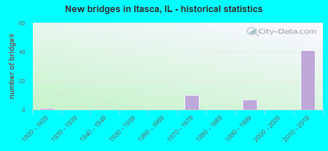
- New bridges - historical statistics
- 11920-1929
- 101970-1979
- 71990-1999
- 412010-2019
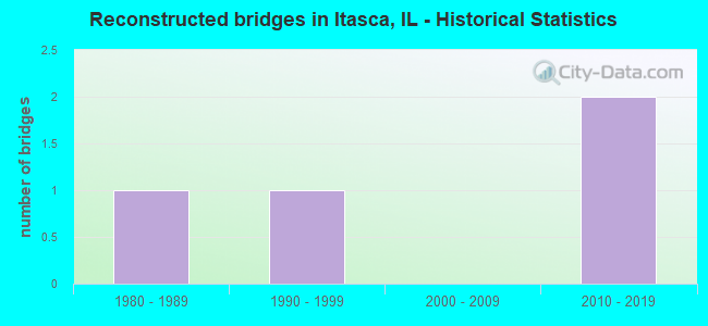
- Reconstructed bridges - Historical Statistics
- 11980-1989
- 11990-1999
- 02000-2009
- 22010-2019
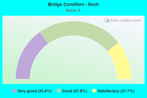
- Bridge Condition - Deck
- 30.4%Very good
- 47.8%Good
- 21.7%Satisfactory
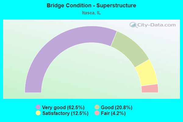
- Bridge Condition - Superstructure
- 62.5%Very good
- 20.8%Good
- 12.5%Satisfactory
- 4.2%Fair
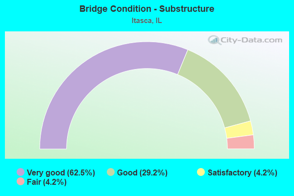
- Bridge Condition - Substructure
- 62.5%Very good
- 29.2%Good
- 4.2%Satisfactory
- 4.2%Fair
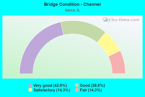
- Bridge Condition - Channel
- 42.9%Very good
- 28.6%Good
- 14.3%Satisfactory
- 14.3%Fair
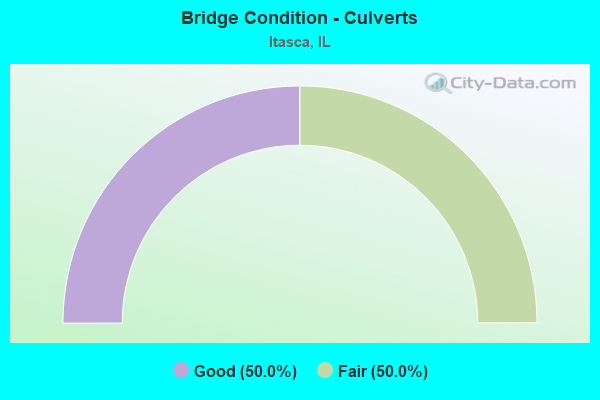
- Bridge Condition - Culverts
- 50.0%Good
- 50.0%Fair
Find on map >> Show street view
Structure Number: 16055, Location: 1.3 M N of IL 19 (Lat: 41.992472, Lng: -88.023947), Route carried "on" structure: Other road , Year Built: 2014, Status: Open, Structure Length: 8.84m (29.00ft), Average Daily Traffic: 21,300 (year 2018), Truck Traffic: 6%, Average Future Daily Traffic: 31,400 (year 2037), Design Load: HS 25 or greater, Features Intersected: I-290, Facility Carried by Structure: DEVON AVE
Minimum Vertical Clearance: 30+ m (98+ ft), Kilometerpoint: 4.989, Lanes on structure: 4, Lanes under structure: 6, Base Highway Network: Yes, Owner: State Highway Agency, Approaching Roadway Width: 20.7m (67.9ft), Skew: 30 degrees, Material/Design: Steel continuous, Design/Construction: Stringer/Multi-beam, Number Of Spans In Main Unit: 2, Length of Maximum Span: 49.3m (161.7ft), Curb or Sidewalk Widths: Left: 3.0m (9.8ft), Right: 2.1m (6.9ft), Curb-To-Curb Width: 20.7m (67.9ft), Out-to-Out Width: 28.7m (94.2ft)
Condition: Deck: Very good, Superstructure: Very good, Substructure: Very good, Operating Rating: 55.7 metric tons, Method Used To Determine Operating Rating: Load and Resistance Factor Rating (LRFR) rating reported by rating factor(RF) method using HL-93 loadings, Inventory Rating: 42.8 metric tons, Method Used To Determine Inventory Rating: Load and Resistance Factor Rating (LRFR) rating reported by rating factor(RF) method using HL-93 loadings, Structural Evaluation: Equal to present desirable criteria, Deck Geometry: Superior to present desirable criteria, Approach Roadway Alignment: Equal to present desirable criteria, Designated Inspection Frequency: Every 24 months, Inspection Date: December 2020, Deck Structure Type: Concrete Cast-file-Place, Wearing Surface/Protective System: Deck Protection: Epoxy Coated Reinforcing
Find on map >> Show street view
Structure Number: 220012, Location: 0.2 M S OF IL 390 (Lat: 41.984689, Lng: -88.031503), Route carried "on" structure: State highway 53, Year Built: 2014, Status: Open, Structure Length: 1.02m (3.35ft), Average Daily Traffic: 14,800 (year 2021), Truck Traffic: 9%, Average Future Daily Traffic: 14,300 (year 2037), Design Load: HS 25 or greater, Features Intersected: STREAM
Minimum Vertical Clearance: 30+ m (98+ ft), Kilometerpoint: 103.108, Lanes on structure: 6, Base Highway Network: Yes, Owner: State Highway Agency, Approaching Roadway Width: 25.8m (84.6ft), Material/Design: Concrete, Design/Construction: Slab, Number Of Spans In Main Unit: 1, Length of Maximum Span: 9.3m (30.5ft), Curb or Sidewalk Widths: Left: 2.4m (7.9ft), Right: 2.4m (7.9ft), Curb-To-Curb Width: 25.8m (84.6ft), Out-to-Out Width: 31.8m (104.3ft)
Condition: Deck: Good, Superstructure: Good, Substructure: Very good, Channel: Very good, Operating Rating: 69.7 metric tons, Method Used To Determine Operating Rating: Load and Resistance Factor Rating (LRFR) rating reported by rating factor(RF) method using HL-93 loadings, Inventory Rating: 53.8 metric tons, Method Used To Determine Inventory Rating: Load and Resistance Factor Rating (LRFR) rating reported by rating factor(RF) method using HL-93 loadings, Structural Evaluation: Better than present minimum criteria, Deck Geometry: Somewhat better than minimum adequacy, Waterway Adequacy: Equal to present desirable criteria, Approach Roadway Alignment: Equal to present desirable criteria, Designated Inspection Frequency: Every 48 months, Inspection Date: August 2021, Deck Structure Type: Concrete Cast-file-Place, Wearing Surface/Protective System: Deck Protection: Epoxy Coated Reinforcing
Find on map >> Show street view
Structure Number: 220064, Location: 0.5 M E OF I-290 (Lat: 41.971139, Lng: -88.013256), Route carried "on" structure: State highway 19, Year Built: 1925, Year Reconstructed: 1985, Status: Open, Structure Length: 0.73m (2.40ft), Average Daily Traffic: 12,900 (year 2021), Truck Traffic: 9%, Average Future Daily Traffic: 15,596 (year 2032), Features Intersected: NORDIC SPRING BROOK
Minimum Vertical Clearance: 30+ m (98+ ft), Kilometerpoint: 22.788, Lanes on structure: 3, Base Highway Network: Yes, Owner: State Highway Agency, Approaching Roadway Width: 13.4m (44.0ft), Skew: 5 degrees, Material/Design: Concrete continuous, Design/Construction: Culvert, Number Of Spans In Main Unit: 2, Length of Maximum Span: 3.7m (12.1ft), Curb-To-Curb Width: 14.9m (48.9ft), Out-to-Out Width: 15.2m (49.9ft)
Condition: Channel: Good, Culverts: Good, Operating Rating: 52.2 metric tons, Method Used To Determine Operating Rating: Load Factor (LF) rating reported by rating factor (RF) method using MS18 loading, Inventory Rating: 32.4 metric tons, Method Used To Determine Inventory Rating: Load Factor (LF) rating reported by rating factor (RF) method using MS18 loading, Structural Evaluation: Better than present minimum criteria, Deck Geometry: Equal to present minimum criteria, Waterway Adequacy: Equal to present minimum criteria, Approach Roadway Alignment: Equal to present minimum criteria, Designated Inspection Frequency: Every 24 months, Inspection Date: October 2020
Find on map >> Show street view
Structure Number: 220091, Location: 3.5 M W IL 83 (Lat: 41.971869, Lng: -88.023958), Route carried "on" structure: State highway 19, Year Built: 1971, Status: Open, Structure Length: 8.53m (27.99ft), Average Daily Traffic: 12,900 (year 2021), Truck Traffic: 9%, Average Future Daily Traffic: 15,596 (year 2032), Design Load: HS 20, Features Intersected: I-290
Minimum Vertical Clearance: 30+ m (98+ ft), Kilometerpoint: 21.790, Lanes on structure: 4, Lanes under structure: 10, Base Highway Network: Yes, Owner: State Highway Agency, Approaching Roadway Width: 20.7m (67.9ft), Skew: 30 degrees, Material/Design: Steel continuous, Design/Construction: Stringer/Multi-beam, Number Of Spans In Main Unit: 2, Number Of Approach Spans: 2, Length of Maximum Span: 31.4m (103.0ft), Curb-To-Curb Width: 20.9m (68.6ft), Out-to-Out Width: 22.6m (74.1ft)
Condition: Deck: Good, Superstructure: Satisfactory, Substructure: Good, Operating Rating: 65.1 metric tons, Method Used To Determine Operating Rating: Load Factor (LF) rating reported by rating factor (RF) method using MS18 loading, Inventory Rating: 38.9 metric tons, Method Used To Determine Inventory Rating: Load Factor (LF) rating reported by rating factor (RF) method using MS18 loading, Structural Evaluation: Equal to present minimum criteria, Deck Geometry: Superior to present desirable criteria, Underclear: Somewhat better than minimum adequacy, Approach Roadway Alignment: Equal to present desirable criteria, Designated Inspection Frequency: Every 24 months, Other Special Inspection Frequency: Every 72 months, Inspection Date: August 2021, Other Special Inspection Date: September 2019, Deck Structure Type: Concrete Cast-file-Place, Wearing Surface/Protective System: Wearing Surface: Latex Concrete
Find on map >> Show street view
Structure Number: 220092, Location: 1.0 M S OF IL 19 (Lat: 41.961011, Lng: -88.026803), Route carried "on" structure: Interstate 290, Year Built: 1971, Year Reconstructed: 1998, Status: Open, Structure Length: 18.53m (60.79ft), Average Daily Traffic: 40,600 (year 2021), Truck Traffic: 24%, Average Future Daily Traffic: 124,378 (year 2032), Design Load: HS 20+Mod, Features Intersected: I-355
Minimum Vertical Clearance: 30+ m (98+ ft), Kilometerpoint: 10.831, Lanes on structure: 2, Lanes under structure: 6, Base Highway Network: Yes, Owner: State Highway Agency, Approaching Roadway Width: 11.0m (36.1ft), Material/Design: Steel continuous, Design/Construction: Stringer/Multi-beam, Number Of Spans In Main Unit: 4, Length of Maximum Span: 70.4m (231.0ft), Curb-To-Curb Width: 13.4m (44.0ft), Out-to-Out Width: 14.0m (45.9ft)
Condition: Deck: Satisfactory, Superstructure: Satisfactory, Substructure: Fair, Operating Rating: 65.1 metric tons, Method Used To Determine Operating Rating: Load Factor (LF) rating reported by rating factor (RF) method using MS18 loading, Inventory Rating: 38.9 metric tons, Method Used To Determine Inventory Rating: Load Factor (LF) rating reported by rating factor (RF) method using MS18 loading, Structural Evaluation: Somewhat better than minimum adequacy, Deck Geometry: Superior to present desirable criteria, Underclear: Meets minimum limits, Approach Roadway Alignment: Equal to present desirable criteria, Designated Inspection Frequency: Every 24 months, Critical Feature Inspection Frequency: Every 24 months, Other Special Inspection Frequency: Every 24 months, Inspection Date: October 2020, Critical Feature Inspection Date: October 2020, Other Special Inspection Date: October 2020, Deck Structure Type: Concrete Cast-file-Place, Wearing Surface/Protective System: Wearing Surface: Latex Concrete
Find on map >> Show street view
Structure Number: 220093, Location: 0.6 M S OF IL 19 (Lat: 41.963975, Lng: -88.026644), Route carried "on" structure: Interstate 290, Year Built: 1970, Status: Open, Structure Length: 0.73m (2.40ft), Average Daily Traffic: 81,200 (year 2021), Truck Traffic: 24%, Average Future Daily Traffic: 248,756 (year 2032), Design Load: HS 20+Mod, Features Intersected: SPRING BROOK
Minimum Vertical Clearance: 30+ m (98+ ft), Kilometerpoint: 10.509, Lanes on structure: 8, Base Highway Network: Yes, Owner: State Highway Agency, Approaching Roadway Width: 29.3m (96.1ft), Skew: 10 degrees, Material/Design: Concrete continuous, Design/Construction: Culvert, Number Of Spans In Main Unit: 2, Length of Maximum Span: 3.7m (12.1ft)
Condition: Channel: Fair, Culverts: Fair, Operating Rating: 81.3 metric tons, Method Used To Determine Operating Rating: Load Factor (LF) rating reported by rating factor (RF) method using MS18 loading, Inventory Rating: 48.6 metric tons, Method Used To Determine Inventory Rating: Load Factor (LF) rating reported by rating factor (RF) method using MS18 loading, Structural Evaluation: Somewhat better than minimum adequacy, Waterway Adequacy: Equal to present desirable criteria, Approach Roadway Alignment: Equal to present desirable criteria, Designated Inspection Frequency: Every 24 months, Inspection Date: June 2021, Deck Structure Type: Other
Find on map >> Show street view
Structure Number: 220106, Location: 1.0 M S OF IL 19 (Lat: 41.961950, Lng: -88.025492), Route carried "on" structure: Other road , Year Built: 1970, Status: Open, Structure Length: 16.18m (53.08ft), Average Daily Traffic: 3,050 (year 2020), Truck Traffic: 2%, Average Future Daily Traffic: 13,591 (year 2032), Design Load: HS 20, Features Intersected: I-290, Facility Carried by Structure: BLOOMINGDALE RD
Minimum Vertical Clearance: 30+ m (98+ ft), Kilometerpoint: 1.481, Lanes on structure: 2, Lanes under structure: 10, Owner: State Highway Agency, Approaching Roadway Width: 13.4m (44.0ft), Skew: 5 degrees, Material/Design: Steel continuous, Design/Construction: Stringer/Multi-beam, Number Of Spans In Main Unit: 4, Length of Maximum Span: 53.0m (173.9ft), Curb-To-Curb Width: 13.4m (44.0ft), Out-to-Out Width: 14.4m (47.2ft)
Condition: Deck: Satisfactory, Superstructure: Satisfactory, Substructure: Good, Operating Rating: 77.8 metric tons, Method Used To Determine Operating Rating: Load Factor (LF) rating reported by rating factor (RF) method using MS18 loading, Inventory Rating: 46.7 metric tons, Method Used To Determine Inventory Rating: Load Factor (LF) rating reported by rating factor (RF) method using MS18 loading, Structural Evaluation: Equal to present minimum criteria, Deck Geometry: Better than present minimum criteria, Underclear: High priority of corrective action, Approach Roadway Alignment: Equal to present desirable criteria, Designated Inspection Frequency: Every 24 months, Other Special Inspection Frequency: Every 48 months, Inspection Date: November 2021, Other Special Inspection Date: January 2022, Deck Structure Type: Concrete Cast-file-Place, Wearing Surface/Protective System: Wearing Surface: Latex Concrete
Find on map >> Show street view
Structure Number: 220179, Location: EAST OF ROSELLE RD (Lat: 41.991958, Lng: -88.046444), Route carried "on" structure: State highway 390, Year Built: 1992, Year Reconstructed: 2015, Status: Open, Structure Length: 6.71m (22.01ft), Average Daily Traffic: 48,200 (year 2020), Truck Traffic: 11%, Average Future Daily Traffic: 40,222 (year 2032), Design Load: HS 20, Features Intersected: MEACHAM/MEDINAH RDS
Minimum Vertical Clearance: 30+ m (98+ ft), Kilometerpoint: 8.079, Lanes on structure: 3, Lanes under structure: 9, Base Highway Network: Yes, Toll: On toll road, Owner: State Toll Authority, Approaching Roadway Width: 17.8m (58.4ft), Material/Design: Steel continuous, Design/Construction: Stringer/Multi-beam, Number Of Spans In Main Unit: 2, Length of Maximum Span: 35.7m (117.1ft), Curb-To-Curb Width: 17.8m (58.4ft), Out-to-Out Width: 18.8m (61.7ft)
Condition: Deck: Satisfactory, Superstructure: Good, Substructure: Good, Operating Rating: 59.3 metric tons, Method Used To Determine Operating Rating: Load Factor (LF) rating reported by rating factor (RF) method using MS18 loading, Inventory Rating: 35.6 metric tons, Method Used To Determine Inventory Rating: Load Factor (LF) rating reported by rating factor (RF) method using MS18 loading, Structural Evaluation: Better than present minimum criteria, Deck Geometry: Better than present minimum criteria, Underclear: High priority of corrective action, Approach Roadway Alignment: Equal to present desirable criteria, Designated Inspection Frequency: Every 24 months, Inspection Date: April 2021, Deck Structure Type: Concrete Cast-file-Place, Wearing Surface/Protective System: Deck Protection: Epoxy Coated Reinforcing
Find on map >> Show street view
Structure Number: 220189, Location: 0.7 M S OF IL 19 (Lat: 41.963469, Lng: -88.031606), Route carried "on" structure: State highway 53, Year Built: 2010, Status: Open, Structure Length: 1.75m (5.74ft), Average Daily Traffic: 15,100 (year 2021), Truck Traffic: 8%, Average Future Daily Traffic: 14,928 (year 2032), Features Intersected: SPRINGBROOK CREEK
Minimum Vertical Clearance: 30+ m (98+ ft), Kilometerpoint: 100.758, Lanes on structure: 4, Base Highway Network: Yes, Owner: State Highway Agency, Approaching Roadway Width: 19.8m (65.0ft), Material/Design: Steel, Design/Construction: Stringer/Multi-beam, Number Of Spans In Main Unit: 1, Length of Maximum Span: 16.8m (55.1ft), Curb or Sidewalk Widths: Left: 2.3m (7.5ft), Right: 2.7m (8.9ft), Curb-To-Curb Width: 21.0m (68.9ft), Out-to-Out Width: 26.7m (87.6ft)
Condition: Deck: Good, Superstructure: Very good, Substructure: Very good, Channel: Very good, Operating Rating: 69.0 metric tons, Method Used To Determine Operating Rating: Load Factor (LF) rating reported by rating factor (RF) method using MS18 loading, Inventory Rating: 41.1 metric tons, Method Used To Determine Inventory Rating: Load Factor (LF) rating reported by rating factor (RF) method using MS18 loading, Structural Evaluation: Equal to present desirable criteria, Deck Geometry: Superior to present desirable criteria, Waterway Adequacy: Equal to present desirable criteria, Approach Roadway Alignment: Equal to present desirable criteria, Designated Inspection Frequency: Every 48 months, Inspection Date: September 2021, Deck Structure Type: Concrete Cast-file-Place, Wearing Surface/Protective System: Deck Protection: Epoxy Coated Reinforcing
Find on map >> Show street view
Structure Number: 220222, Location: EAST OF ROSELLE RD (Lat: 41.991958, Lng: -88.046444), Route carried "on" structure: State highway 390, Year Built: 1992, Year Reconstructed: 2015, Status: Open, Structure Length: 6.71m (22.01ft), Average Daily Traffic: 48,200 (year 2020), Truck Traffic: 11%, Average Future Daily Traffic: 40,222 (year 2032), Design Load: HS 20, Features Intersected: MEACHAM/MEDINAH RD
Minimum Vertical Clearance: 30+ m (98+ ft), Kilometerpoint: 8.079, Lanes on structure: 3, Lanes under structure: 9, Base Highway Network: Yes, Toll: On toll road, Owner: State Toll Authority, Approaching Roadway Width: 18.0m (59.1ft), Material/Design: Steel continuous, Design/Construction: Stringer/Multi-beam, Number Of Spans In Main Unit: 2, Length of Maximum Span: 35.7m (117.1ft), Curb-To-Curb Width: 18.0m (59.1ft), Out-to-Out Width: 19.0m (62.3ft)
Condition: Deck: Good, Superstructure: Good, Substructure: Good, Operating Rating: 61.2 metric tons, Method Used To Determine Operating Rating: Load Factor (LF) rating reported by rating factor (RF) method using MS18 loading, Inventory Rating: 36.9 metric tons, Method Used To Determine Inventory Rating: Load Factor (LF) rating reported by rating factor (RF) method using MS18 loading, Structural Evaluation: Better than present minimum criteria, Deck Geometry: Better than present minimum criteria, Underclear: High priority of corrective action, Approach Roadway Alignment: Equal to present desirable criteria, Designated Inspection Frequency: Every 24 months, Inspection Date: April 2021, Deck Structure Type: Concrete Cast-file-Place, Wearing Surface/Protective System: Deck Protection: Epoxy Coated Reinforcing
Find on map >> Show street view
Structure Number: 220533, Location: 0.5 M W of I-290 (Lat: 41.988178, Lng: -88.031544), Route carried "on" structure: State highway 53, Year Built: 2014, Status: Open, Structure Length: 13.46m (44.16ft), Average Daily Traffic: 14,800 (year 2021), Truck Traffic: 9%, Average Future Daily Traffic: 14,300 (year 2037), Design Load: HS 25 or greater, Features Intersected: IL 390 ELGIN-O'HARE
Minimum Vertical Clearance: 30+ m (98+ ft), Kilometerpoint: 103.510, Lanes on structure: 4, Lanes under structure: 8, Base Highway Network: Yes, Owner: State Highway Agency, Approaching Roadway Width: 24.1m (79.1ft), Skew: 31 degrees, Material/Design: Prestressed concrete continuous, Design/Construction: Stringer/Multi-beam, Number Of Spans In Main Unit: 4, Length of Maximum Span: 37.0m (121.4ft), Curb or Sidewalk Widths: Left: 1.8m (5.9ft), Right: 3.0m (9.8ft), Curb-To-Curb Width: 24.1m (79.1ft), Out-to-Out Width: 31.2m (102.4ft)
Condition: Deck: Satisfactory, Superstructure: Very good, Substructure: Very good, Operating Rating: 49.6 metric tons, Method Used To Determine Operating Rating: Load and Resistance Factor Rating (LRFR) rating reported by rating factor(RF) method using HL-93 loadings, Inventory Rating: 38.2 metric tons, Method Used To Determine Inventory Rating: Load and Resistance Factor Rating (LRFR) rating reported by rating factor(RF) method using HL-93 loadings, Structural Evaluation: Equal to present desirable criteria, Deck Geometry: Superior to present desirable criteria, Underclear: High priority of corrective action, Approach Roadway Alignment: Equal to present desirable criteria, Designated Inspection Frequency: Every 24 months, Inspection Date: September 2020, Deck Structure Type: Concrete Cast-file-Place, Wearing Surface/Protective System: Deck Protection: Epoxy Coated Reinforcing
Find on map >> Show street view
Structure Number: 220534, Location: AT 1290 ELGIN INTERC (Lat: 41.982283, Lng: -88.022714), Route carried "on" structure: Other road , Year Built: 2015, Status: Open, Structure Length: 64.09m (210.27ft), Average Daily Traffic: 15,400 (year 2020), Truck Traffic: 1%, Average Future Daily Traffic: 20,000 (year 2032), Design Load: HS 25 or greater, Features Intersected: I-290 & IL 390 EOH, Facility Carried by Structure: I-290 WB 2 IL 390W
Minimum Vertical Clearance: 30+ m (98+ ft), Kilometerpoint: 0.805, Lanes on structure: 2, Lanes under structure: 17, Base Highway Network: Yes (Inventory Route: 10290040, Subroute: 80), Owner: State Highway Agency, Approaching Roadway Width: 14.0m (45.9ft), Material/Design: Steel continuous, Design/Construction: Stringer/Multi-beam, Number Of Spans In Main Unit: 9, Length of Maximum Span: 76.2m (250.0ft), Curb-To-Curb Width: 14.0m (45.9ft), Out-to-Out Width: 15.0m (49.2ft)
Condition: Deck: Good, Superstructure: Good, Substructure: Good, Operating Rating: 40.5 metric tons, Method Used To Determine Operating Rating: Load and Resistance Factor Rating (LRFR) rating reported by rating factor(RF) method using HL-93 loadings, Inventory Rating: 33.4 metric tons, Method Used To Determine Inventory Rating: Load and Resistance Factor Rating (LRFR) rating reported by rating factor(RF) method using HL-93 loadings, Structural Evaluation: Better than present minimum criteria, Deck Geometry: Superior to present desirable criteria, Underclear: Meets minimum limits, Approach Roadway Alignment: Equal to present desirable criteria, Designated Inspection Frequency: Every 24 months, Inspection Date: May 2021, Deck Structure Type: Concrete Cast-file-Place, Wearing Surface/Protective System: Deck Protection: Epoxy Coated Reinforcing
Find on map >> Show street view
Structure Number: 220549, Location: Just E of I290 (Lat: 41.983786, Lng: -88.018986), Route carried "on" structure: Other road , Year Built: 2016, Status: Open, Structure Length: 5.25m (17.22ft), Average Daily Traffic: 7,300 (year 2020), Truck Traffic: 8%, Average Future Daily Traffic: 5,000 (year 2040), Design Load: HS 25 or greater, Features Intersected: I-290SB 2 IL 390 EB, Facility Carried by Structure: I-290 WB TO IL 390
Minimum Vertical Clearance: 30+ m (98+ ft), Kilometerpoint: 0.354, Lanes on structure: 1, Lanes under structure: 1, Base Highway Network: Yes (Inventory Route: 10290Q40, Subroute: 80), Owner: State Highway Agency, Approaching Roadway Width: 11.0m (36.1ft), Skew: 6 degrees, Material/Design: Steel, Design/Construction: Stringer/Multi-beam, Number Of Spans In Main Unit: 1, Length of Maximum Span: 46.3m (151.9ft), Curb-To-Curb Width: 9.8m (32.2ft), Out-to-Out Width: 10.7m (35.1ft)
Condition: Deck: Very good, Superstructure: Very good, Substructure: Very good, Operating Rating: 68.7 metric tons, Method Used To Determine Operating Rating: Load and Resistance Factor Rating (LRFR) rating reported by rating factor(RF) method using HL-93 loadings, Inventory Rating: 53.1 metric tons, Method Used To Determine Inventory Rating: Load and Resistance Factor Rating (LRFR) rating reported by rating factor(RF) method using HL-93 loadings, Structural Evaluation: Equal to present desirable criteria, Deck Geometry: Meets minimum limits, Approach Roadway Alignment: Equal to present desirable criteria, Designated Inspection Frequency: Every 24 months, Inspection Date: July 2021, Deck Structure Type: Concrete Cast-file-Place, Wearing Surface/Protective System: Deck Protection: Epoxy Coated Reinforcing
Find on map >> Show street view
Structure Number: 220556, Location: 0.04 M S of Devon (Lat: 41.988542, Lng: -88.024778), Route carried "on" structure: Other road , Year Built: 2016, Status: Open, Structure Length: 3.41m (11.19ft), Average Daily Traffic: 3,200 (year 2020), Average Future Daily Traffic: 2,000 (year 2032), Design Load: HS 25 or greater, Features Intersected: IL 390WB TO I-290SB, Facility Carried by Structure: I-290 EB TO IL 390
Minimum Vertical Clearance: 30+ m (98+ ft), Kilometerpoint: 0.241, Lanes on structure: 2, Lanes under structure: 1, Base Highway Network: Yes (Inventory Route: 10290040, Subroute: 20), Owner: State Highway Agency, Approaching Roadway Width: 12.8m (42.0ft), Skew: 3 degrees, Material/Design: Prestressed concrete, Design/Construction: Stringer/Multi-beam, Number Of Spans In Main Unit: 1, Length of Maximum Span: 31.4m (103.0ft), Curb-To-Curb Width: 12.8m (42.0ft), Out-to-Out Width: 13.8m (45.3ft)
Condition: Deck: Good, Superstructure: Very good, Substructure: Very good, Operating Rating: 62.9 metric tons, Method Used To Determine Operating Rating: Load and Resistance Factor Rating (LRFR) rating reported by rating factor(RF) method using HL-93 loadings, Inventory Rating: 45.7 metric tons, Method Used To Determine Inventory Rating: Load and Resistance Factor Rating (LRFR) rating reported by rating factor(RF) method using HL-93 loadings, Structural Evaluation: Equal to present desirable criteria, Deck Geometry: Equal to present desirable criteria, Approach Roadway Alignment: Better than present minimum criteria, Designated Inspection Frequency: Every 24 months, Inspection Date: October 2020, Deck Structure Type: Concrete Cast-file-Place, Wearing Surface/Protective System: Deck Protection: Epoxy Coated Reinforcing
Find on map >> Show street view
Structure Number: 220557, Location: 0.041 M S of DEVON (Lat: 41.987106, Lng: -88.025297), Route carried "on" structure: Other road , Year Built: 2016, Status: Open, Structure Length: 32.62m (107.02ft), Average Daily Traffic: 3,200 (year 2020), Average Future Daily Traffic: 2,000 (year 2032), Design Load: HS 25 or greater, Features Intersected: I-290 & IL 390, Facility Carried by Structure: I-290 EB TO IL 390
Minimum Vertical Clearance: 30+ m (98+ ft), Kilometerpoint: 0.402, Lanes on structure: 2, Lanes under structure: 31, Base Highway Network: Yes (Inventory Route: 10290040, Subroute: 20), Owner: State Highway Agency, Approaching Roadway Width: 14.0m (45.9ft), Material/Design: Steel continuous, Design/Construction: Stringer/Multi-beam, Number Of Spans In Main Unit: 5, Length of Maximum Span: 79.2m (259.8ft), Curb-To-Curb Width: 14.0m (45.9ft), Out-to-Out Width: 15.0m (49.2ft)
Condition: Deck: Good, Superstructure: Good, Substructure: Very good, Operating Rating: 67.7 metric tons, Method Used To Determine Operating Rating: Load and Resistance Factor Rating (LRFR) rating reported by rating factor(RF) method using HL-93 loadings, Inventory Rating: 52.5 metric tons, Method Used To Determine Inventory Rating: Load and Resistance Factor Rating (LRFR) rating reported by rating factor(RF) method using HL-93 loadings, Structural Evaluation: Better than present minimum criteria, Deck Geometry: Superior to present desirable criteria, Underclear: High priority of corrective action, Approach Roadway Alignment: Equal to present desirable criteria, Designated Inspection Frequency: Every 24 months, Inspection Date: Febuary 2021, Deck Structure Type: Concrete Cast-file-Place, Wearing Surface/Protective System: Deck Protection: Epoxy Coated Reinforcing
Find on map >> Show street view
Structure Number: 220564, Location: 100' N of Thorndale (Lat: 41.985219, Lng: -88.023208), Route carried "on" structure: State highway 390, Year Built: 2016, Status: Open, Structure Length: 9.25m (30.35ft), Average Daily Traffic: 13,900 (year 2020), Truck Traffic: 32%, Average Future Daily Traffic: 85,728 (year 2032), Design Load: HS 25 or greater, Features Intersected: I290
Minimum Vertical Clearance: 30+ m (98+ ft), Kilometerpoint: 10.171, Lanes on structure: 8, Lanes under structure: 10, Base Highway Network: Yes, Owner: State Toll Authority, Approaching Roadway Width: 16.8m (55.1ft), Skew: 1 degrees, Material/Design: Steel, Design/Construction: Stringer/Multi-beam, Number Of Spans In Main Unit: 2, Length of Maximum Span: 47.2m (154.9ft), Curb-To-Curb Width: 16.8m (55.1ft), Out-to-Out Width: 29.3m (96.1ft)
Condition: Deck: Very good, Superstructure: Very good, Substructure: Very good, Operating Rating: 75.5 metric tons, Method Used To Determine Operating Rating: Load and Resistance Factor Rating (LRFR) rating reported by rating factor(RF) method using HL-93 loadings, Inventory Rating: 58.3 metric tons, Method Used To Determine Inventory Rating: Load and Resistance Factor Rating (LRFR) rating reported by rating factor(RF) method using HL-93 loadings, Structural Evaluation: Equal to present desirable criteria, Deck Geometry: High priority of replacement, Underclear: Meets minimum limits, Approach Roadway Alignment: Equal to present desirable criteria, Designated Inspection Frequency: Every 24 months, Inspection Date: July 2020, Deck Structure Type: Concrete Cast-file-Place, Wearing Surface/Protective System: Deck Protection: Epoxy Coated Reinforcing
Find on map >> Show street view
Structure Number: 220566, Location: 250' S of Thorndale (Lat: 41.984953, Lng: -88.023950), Route carried "on" structure: Other road , Year Built: 2016, Status: Open, Structure Length: 9.48m (31.10ft), Average Daily Traffic: 8,200 (year 2020), Truck Traffic: 3%, Average Future Daily Traffic: 2,000 (year 2032), Design Load: HS 25 or greater, Features Intersected: I-290, Facility Carried by Structure: EB IL390 to NBI290
Minimum Vertical Clearance: 30+ m (98+ ft), Kilometerpoint: 0.418, Lanes on structure: 2, Lanes under structure: 20, Base Highway Network: Yes (Inventory Route: 10290Q40, Subroute: 60), Toll: On toll road, Owner: State Toll Authority, Approaching Roadway Width: 7.3m (24.0ft), Skew: 1 degrees, Material/Design: Prestressed concrete, Design/Construction: Stringer/Multi-beam, Number Of Spans In Main Unit: 2, Length of Maximum Span: 47.0m (154.2ft), Curb-To-Curb Width: 7.3m (24.0ft), Out-to-Out Width: 12.2m (40.0ft)
Condition: Deck: Good, Superstructure: Very good, Substructure: Good, Operating Rating: 62.2 metric tons, Method Used To Determine Operating Rating: Load and Resistance Factor Rating (LRFR) rating reported by rating factor(RF) method using HL-93 loadings, Inventory Rating: 48.0 metric tons, Method Used To Determine Inventory Rating: Load and Resistance Factor Rating (LRFR) rating reported by rating factor(RF) method using HL-93 loadings, Structural Evaluation: Better than present minimum criteria, Deck Geometry: High priority of replacement, Underclear: Meets minimum limits, Approach Roadway Alignment: Equal to present minimum criteria, Designated Inspection Frequency: Every 24 months, Inspection Date: October 2020, Deck Structure Type: Concrete Cast-file-Place, Wearing Surface/Protective System: Deck Protection: Bituminous
Find on map >> Show street view
Structure Number: 223102, Location: 0.4 MI N OF IL-19 (Lat: 41.971894, Lng: -87.998139), Route carried "on" structure: Other road , Year Built: 1994, Status: Open, Structure Length: 4.08m (13.39ft), Average Daily Traffic: 7,900 (year 2020), Truck Traffic: 8%, Average Future Daily Traffic: 7,018 (year 2032), Design Load: HS 20, Features Intersected: Springbrook, Facility Carried by Structure: FAU-2635 Prospect
Minimum Vertical Clearance: 30+ m (98+ ft), Kilometerpoint: 1.320, Lanes on structure: 4, Base Highway Network: Yes, Owner: County Highway Agency, Approaching Roadway Width: 20.4m (66.9ft), Skew: 20 degrees, Material/Design: Steel continuous, Design/Construction: Stringer/Multi-beam, Number Of Spans In Main Unit: 2, Length of Maximum Span: 20.1m (65.9ft), Curb or Sidewalk Widths: Left: 2.4m (7.9ft), Right: 0.0m, Curb-To-Curb Width: 20.4m (66.9ft), Out-to-Out Width: 24.0m (78.7ft)
Condition: Deck: Satisfactory, Superstructure: Fair, Substructure: Satisfactory, Channel: Satisfactory, Operating Rating: 70.3 metric tons, Method Used To Determine Operating Rating: Load Factor (LF) rating reported by rating factor (RF) method using MS18 loading, Inventory Rating: 42.1 metric tons, Method Used To Determine Inventory Rating: Load Factor (LF) rating reported by rating factor (RF) method using MS18 loading, Structural Evaluation: Somewhat better than minimum adequacy, Deck Geometry: Superior to present desirable criteria, Waterway Adequacy: Equal to present minimum criteria, Approach Roadway Alignment: Equal to present desirable criteria, Designated Inspection Frequency: Every 24 months, Inspection Date: September 2020, Deck Structure Type: Concrete Cast-file-Place, Wearing Surface/Protective System: Deck Protection: Epoxy Coated Reinforcing
Find on map >> Show street view
Structure Number: 226602, Location: 300 FT S OF IL-19 (Lat: 41.971322, Lng: -88.014539), Route carried "on" structure: City street , Year Built: 2015, Status: Open, Structure Length: 1.01m (3.31ft), Average Daily Traffic: 475 (year 2020), Truck Traffic: 5%, Average Future Daily Traffic: 567 (year 2032), Design Load: HS 25 or greater, Features Intersected: Spring Brook, Facility Carried by Structure: MS-2020 (Maple Av)
Minimum Vertical Clearance: 30+ m (98+ ft), Kilometerpoint: 0.016, Lanes on structure: 2, Owner: City or Municipal Highway Agency, Approaching Roadway Width: 7.9m (25.9ft), Skew: 2 degrees, Material/Design: Concrete, Design/Construction: Frame, Number Of Spans In Main Unit: 1, Length of Maximum Span: 10.1m (33.1ft), Curb or Sidewalk Widths: Left: 1.5m (4.9ft), Right: 1.5m (4.9ft), Curb-To-Curb Width: 7.9m (25.9ft), Out-to-Out Width: 16.8m (55.1ft)
Condition: Superstructure: Very good, Substructure: Very good, Channel: Good, Operating Rating: 42.1 metric tons, Method Used To Determine Operating Rating: Assigned ratings based on Load and Resistance Factor Design (LRFD) reported by rating factor (RF) using HL93 loadings, Inventory Rating: 32.4 metric tons, Method Used To Determine Inventory Rating: Assigned ratings based on Load and Resistance Factor Design (LRFD) reported by rating factor (RF) using HL93 loadings, Structural Evaluation: Equal to present desirable criteria, Deck Geometry: Somewhat better than minimum adequacy, Waterway Adequacy: Equal to present desirable criteria, Approach Roadway Alignment: Equal to present desirable criteria, Designated Inspection Frequency: Every 48 months, Inspection Date: September 2018, Wearing Surface/Protective System: Wearing Surface: Bituminous
Find on map >> Show street view
Structure Number: 229001, Location: 1.3 MI E. OF I 290 (Lat: 41.983256, Lng: -87.998992), Route carried "on" structure: State highway 390, Year Built: 2017, Status: Open, Structure Length: 6.94m (22.77ft), Average Daily Traffic: 26,400 (year 2020), Truck Traffic: 14%, Average Future Daily Traffic: 11,800 (year 2042), Design Load: HS 25 or greater, Features Intersected: PROSPECT AVE
Minimum Vertical Clearance: 30+ m (98+ ft), Kilometerpoint: 12.231, Lanes on structure: 3, Lanes under structure: 9, Base Highway Network: Yes, Owner: State Toll Authority, Approaching Roadway Width: 19.4m (63.6ft), Skew: 1 degrees, Material/Design: Prestressed concrete continuous, Design/Construction: Stringer/Multi-beam, Number Of Spans In Main Unit: 2, Length of Maximum Span: 37.9m (124.3ft), Curb-To-Curb Width: 19.4m (63.6ft), Out-to-Out Width: 20.4m (66.9ft)
Condition: Deck: Very good, Superstructure: Very good, Substructure: Very good, Operating Rating: 57.3 metric tons, Method Used To Determine Operating Rating: Load and Resistance Factor Rating (LRFR) rating reported by rating factor(RF) method using HL-93 loadings, Inventory Rating: 44.4 metric tons, Method Used To Determine Inventory Rating: Load and Resistance Factor Rating (LRFR) rating reported by rating factor(RF) method using HL-93 loadings, Structural Evaluation: Equal to present desirable criteria, Deck Geometry: Superior to present desirable criteria, Approach Roadway Alignment: Equal to present desirable criteria, Designated Inspection Frequency: Every 24 months, Inspection Date: April 2020, Deck Structure Type: Concrete Cast-file-Place, Wearing Surface/Protective System: Deck Protection: Epoxy Coated Reinforcing
Find on map >> Show street view
Structure Number: 229002, Location: 1.3 MI E OF I 290 (Lat: 41.983256, Lng: -87.998992), Route carried "on" structure: State highway 390, Year Built: 2017, Status: Open, Structure Length: 6.94m (22.77ft), Average Daily Traffic: 26,400 (year 2020), Truck Traffic: 14%, Average Future Daily Traffic: 11,800 (year 2042), Design Load: HS 25 or greater, Features Intersected: PROSPECT AVE
Minimum Vertical Clearance: 30+ m (98+ ft), Kilometerpoint: 12.231, Lanes on structure: 3, Lanes under structure: 9, Base Highway Network: Yes, Owner: State Toll Authority, Approaching Roadway Width: 19.4m (63.6ft), Skew: 1 degrees, Material/Design: Prestressed concrete continuous, Design/Construction: Stringer/Multi-beam, Number Of Spans In Main Unit: 2, Length of Maximum Span: 37.9m (124.3ft), Curb-To-Curb Width: 19.4m (63.6ft), Out-to-Out Width: 20.4m (66.9ft)
Condition: Deck: Very good, Superstructure: Very good, Substructure: Very good, Operating Rating: 57.3 metric tons, Method Used To Determine Operating Rating: Load and Resistance Factor Rating (LRFR) rating reported by rating factor(RF) method using HL-93 loadings, Inventory Rating: 44.4 metric tons, Method Used To Determine Inventory Rating: Load and Resistance Factor Rating (LRFR) rating reported by rating factor(RF) method using HL-93 loadings, Structural Evaluation: Equal to present desirable criteria, Deck Geometry: Superior to present desirable criteria, Approach Roadway Alignment: Equal to present desirable criteria, Designated Inspection Frequency: Every 24 months, Inspection Date: April 2020, Deck Structure Type: Concrete Cast-file-Place, Wearing Surface/Protective System: Deck Protection: Epoxy Coated Reinforcing
Find on map >> Show street view
Structure Number: 229003, Location: 1.7 MI E I 290 (Lat: 41.983139, Lng: -87.991450), Route carried "on" structure: State highway 390, Year Built: 2015, Status: Open, Structure Length: 6.93m (22.74ft), Average Daily Traffic: 26,400 (year 2020), Truck Traffic: 14%, Average Future Daily Traffic: 23,700 (year 2038), Design Load: HS 25 or greater, Features Intersected: SALT CREEK
Minimum Vertical Clearance: 30+ m (98+ ft), Kilometerpoint: 12.874, Lanes on structure: 3, Base Highway Network: Yes, Toll: On toll road, Owner: State Toll Authority, Approaching Roadway Width: 18.9m (62.0ft), Material/Design: Steel continuous, Design/Construction: Stringer/Multi-beam, Number Of Spans In Main Unit: 2, Length of Maximum Span: 36.4m (119.4ft), Curb-To-Curb Width: 19.6m (64.3ft), Out-to-Out Width: 20.6m (67.6ft)
Condition: Deck: Good, Superstructure: Very good, Substructure: Good, Channel: Very good, Operating Rating: 68.4 metric tons, Method Used To Determine Operating Rating: Load and Resistance Factor Rating (LRFR) rating reported by rating factor(RF) method using HL-93 loadings, Inventory Rating: 40.2 metric tons, Method Used To Determine Inventory Rating: Load and Resistance Factor Rating (LRFR) rating reported by rating factor(RF) method using HL-93 loadings, Structural Evaluation: Better than present minimum criteria, Deck Geometry: Superior to present desirable criteria, Waterway Adequacy: Equal to present desirable criteria, Approach Roadway Alignment: Equal to present desirable criteria, Designated Inspection Frequency: Every 24 months, Inspection Date: September 2020, Deck Structure Type: Concrete Cast-file-Place, Wearing Surface/Protective System: Deck Protection: Epoxy Coated Reinforcing
Find on map >> Show street view
Structure Number: 229009, Location: 270' N THORNDALE (Lat: 41.983744, Lng: -88.013178), Route carried "on" structure: State highway 390, Year Built: 2016, Status: Open, Structure Length: 3.80m (12.47ft), Average Daily Traffic: 15,700 (year 2020), Truck Traffic: 28%, Average Future Daily Traffic: 22,860 (year 2038), Design Load: HS 25 or greater, Features Intersected: HAMILTON LAKES DR
Minimum Vertical Clearance: 30+ m (98+ ft), Kilometerpoint: 11.040, Lanes on structure: 3, Base Highway Network: Yes, Owner: State Toll Authority, Approaching Roadway Width: 18.6m (61.0ft), Material/Design: Prestressed concrete, Design/Construction: Stringer/Multi-beam, Number Of Spans In Main Unit: 1, Length of Maximum Span: 36.9m (121.1ft), Curb-To-Curb Width: 18.8m (61.7ft), Out-to-Out Width: 19.9m (65.3ft)
Condition: Deck: Very good, Superstructure: Very good, Substructure: Very good, Operating Rating: 65.4 metric tons, Method Used To Determine Operating Rating: Load and Resistance Factor Rating (LRFR) rating reported by rating factor(RF) method using HL-93 loadings, Inventory Rating: 40.2 metric tons, Method Used To Determine Inventory Rating: Load and Resistance Factor Rating (LRFR) rating reported by rating factor(RF) method using HL-93 loadings, Structural Evaluation: Equal to present desirable criteria, Deck Geometry: Superior to present desirable criteria, Approach Roadway Alignment: Equal to present desirable criteria, Designated Inspection Frequency: Every 24 months, Inspection Date: October 2020, Deck Structure Type: Concrete Cast-file-Place, Wearing Surface/Protective System: Deck Protection: Epoxy Coated Reinforcing
Find on map >> Show street view
Structure Number: 229011, Location: 150' N THORNDALE (Lat: 41.983775, Lng: -88.004125), Route carried "on" structure: State highway 390, Year Built: 2017, Status: Open, Structure Length: 4.08m (13.39ft), Average Daily Traffic: 26,400 (year 2020), Truck Traffic: 14%, Average Future Daily Traffic: 45,720 (year 2038), Design Load: HS 25 or greater, Features Intersected: ARLINGTON HEIGHTS RD
Minimum Vertical Clearance: 30+ m (98+ ft), Kilometerpoint: 11.796, Lanes on structure: 4, Lanes under structure: 4, Base Highway Network: Yes, Owner: State Toll Authority, Approaching Roadway Width: 24.0m (78.7ft), Skew: 1 degrees, Material/Design: Prestressed concrete, Design/Construction: Stringer/Multi-beam, Number Of Spans In Main Unit: 1, Length of Maximum Span: 39.4m (129.3ft), Curb-To-Curb Width: 24.0m (78.7ft), Out-to-Out Width: 25.5m (83.7ft)
Condition: Deck: Good, Superstructure: Very good, Substructure: Very good, Operating Rating: 69.7 metric tons, Method Used To Determine Operating Rating: Load and Resistance Factor Rating (LRFR) rating reported by rating factor(RF) method using HL-93 loadings, Inventory Rating: 40.5 metric tons, Method Used To Determine Inventory Rating: Load and Resistance Factor Rating (LRFR) rating reported by rating factor(RF) method using HL-93 loadings, Structural Evaluation: Equal to present desirable criteria, Deck Geometry: Superior to present desirable criteria, Approach Roadway Alignment: Equal to present desirable criteria, Designated Inspection Frequency: Every 24 months, Inspection Date: October 2020, Deck Structure Type: Concrete Cast-file-Place, Wearing Surface/Protective System: Deck Protection: Epoxy Coated Reinforcing
Find on map >> Show street view
Structure Number: 229012, Location: 50' N THORNDALE (Lat: 41.983792, Lng: -88.004506), Route carried "on" structure: State highway 390, Year Built: 2017, Status: Open, Structure Length: 4.08m (13.39ft), Average Daily Traffic: 15,700 (year 2020), Truck Traffic: 28%, Average Future Daily Traffic: 28,200 (year 2042), Design Load: HS 25 or greater, Features Intersected: ARLINGTON HEIGHTS RD
Minimum Vertical Clearance: 30+ m (98+ ft), Kilometerpoint: 11.764, Lanes on structure: 4, Lanes under structure: 4, Base Highway Network: Yes, Owner: State Toll Authority, Approaching Roadway Width: 29.6m (97.1ft), Skew: 1 degrees, Material/Design: Prestressed concrete, Design/Construction: Stringer/Multi-beam, Number Of Spans In Main Unit: 1, Length of Maximum Span: 39.4m (129.3ft), Curb-To-Curb Width: 29.6m (97.1ft), Out-to-Out Width: 31.7m (104.0ft)
Condition: Deck: Good, Superstructure: Very good, Substructure: Very good, Operating Rating: 69.7 metric tons, Method Used To Determine Operating Rating: Load and Resistance Factor Rating (LRFR) rating reported by rating factor(RF) method using HL-93 loadings, Inventory Rating: 40.5 metric tons, Method Used To Determine Inventory Rating: Load and Resistance Factor Rating (LRFR) rating reported by rating factor(RF) method using HL-93 loadings, Structural Evaluation: Equal to present desirable criteria, Deck Geometry: Superior to present desirable criteria, Approach Roadway Alignment: Equal to present desirable criteria, Designated Inspection Frequency: Every 24 months, Inspection Date: August 2020, Deck Structure Type: Concrete Cast-file-Place, Wearing Surface/Protective System: Deck Protection: Epoxy Coated Reinforcing
Find on map >> Show street view
Structure Number: 229501, Location: 0.8 m E of IL 53 (Lat: 41.987922, Lng: -88.029731), Route carried "on" structure: Other road , Year Built: 2016, Status: Open, Structure Length: 4.03m (13.22ft), Average Daily Traffic: 450 (year 2020), Truck Traffic: 49%, Average Future Daily Traffic: 2,000 (year 2032), Design Load: HS 25 or greater, Features Intersected: Ramps G2 & G3, Facility Carried by Structure: Elgin O'Hare Ramp
Minimum Vertical Clearance: 30+ m (98+ ft), Kilometerpoint: 0.418, Lanes on structure: 1, Lanes under structure: 6, Base Highway Network: Yes (Inventory Route: 20345B40, Subroute: 20), Toll: On toll road, Owner: State Toll Authority, Approaching Roadway Width: 7.3m (24.0ft), Skew: 5 degrees, Material/Design: Concrete, Design/Construction: Slab, Number Of Spans In Main Unit: 1, Length of Maximum Span: 36.0m (118.1ft), Curb-To-Curb Width: 7.3m (24.0ft), Out-to-Out Width: 14.9m (48.9ft)
Condition: Deck: Very good, Superstructure: Very good, Substructure: Very good, Operating Rating: 65.4 metric tons, Method Used To Determine Operating Rating: Load and Resistance Factor Rating (LRFR) rating reported by rating factor(RF) method using HL-93 loadings, Inventory Rating: 50.5 metric tons, Method Used To Determine Inventory Rating: Load and Resistance Factor Rating (LRFR) rating reported by rating factor(RF) method using HL-93 loadings, Structural Evaluation: Equal to present desirable criteria, Deck Geometry: Meets minimum limits, Approach Roadway Alignment: Equal to present minimum criteria, Designated Inspection Frequency: Every 24 months, Inspection Date: October 2020, Deck Structure Type: Concrete Cast-file-Place, Wearing Surface/Protective System: Deck Protection: Epoxy Coated Reinforcing
Find on map >> Show street view
Structure Number: 16055, Location: 1.3 M N of IL 19 (Lat: 41.992464, Lng: -88.023747), Route carried "under" structure: Interstate 290, Year Built: 2014, Structure Length: 0. m, Average Daily Traffic: 154,000 (year 2021), Truck Traffic: 10%, Features Intersected: I-290, Facility Carried by Structure: DEVON AVE
Minimum Vertical Clearance: 5.59m (18.34ft), Kilometerpoint: 7.242, Lanes on structure: 4, Lanes under structure: 6, Material/Design: Steel continuous, Design/Construction: Stringer/Multi-beam, Length of Maximum Span: 49.3m (161.7ft)
Find on map >> Show street view
Structure Number: 220091, Location: 3.5 M W IL 83 (Lat: 41.971997, Lng: -88.024939), Route carried "under" structure: Interstate 290, Year Built: 1971, Structure Length: 0. m, Average Daily Traffic: 183,600 (year 2021), Truck Traffic: 10%, Features Intersected: I-290, Facility Carried by Structure: IL 19
Minimum Vertical Clearance: 4.95m (16.24ft), Kilometerpoint: 9.608, Lanes on structure: 4, Lanes under structure: 10, Material/Design: Steel continuous, Design/Construction: Stringer/Multi-beam, Length of Maximum Span: 31.4m (103.0ft)
Find on map >> Show street view
Structure Number: 220092, Location: 1.0 M S OF IL 19 (Lat: 41.960411, Lng: -88.026508), Route carried "under" structure: Interstate 355, Year Built: 1971, Structure Length: 0. m, Average Daily Traffic: 108,200 (year 2021), Truck Traffic: 13%, Features Intersected: I-355, Facility Carried by Structure: I-290 SB
Minimum Vertical Clearance: 5.87m (19.26ft), Kilometerpoint: 51.723, Lanes on structure: 2, Lanes under structure: 6, Material/Design: Steel continuous, Design/Construction: Stringer/Multi-beam, Length of Maximum Span: 70.4m (231.0ft)
Find on map >> Show street view
Structure Number: 220106, Location: 1.0 M S OF IL 19 (Lat: 41.961239, Lng: -88.026861), Route carried "under" structure: Interstate 290, Year Built: 1970, Structure Length: 0. m, Average Daily Traffic: 81,200 (year 2021), Truck Traffic: 24%, Features Intersected: I-290, Facility Carried by Structure: BLOOMINGDALE RD
Minimum Vertical Clearance: 9.73m (31.92ft), Kilometerpoint: 10.814, Lanes on structure: 2, Lanes under structure: 4, Material/Design: Steel continuous, Design/Construction: Stringer/Multi-beam, Length of Maximum Span: 53.0m (173.9ft)
Find on map >> Show street view
Structure Number: 220106, Location: 1.0 M S OF IL 19 (Lat: 41.961592, Lng: -88.026375), Route carried "under" structure: Interstate 355, Year Built: 1970, Structure Length: 0. m, Average Daily Traffic: 108,200 (year 2021), Truck Traffic: 13%, Features Intersected: I-290, Facility Carried by Structure: BLOOMINGDALE RD
Minimum Vertical Clearance: 9.50m (31.17ft), Kilometerpoint: 51.980, Lanes on structure: 2, Lanes under structure: 6, Material/Design: Steel continuous, Design/Construction: Stringer/Multi-beam, Length of Maximum Span: 53.0m (173.9ft)
Find on map >> Show street view
Structure Number: 220107, Location: 0.1 M N IL 19 (Lat: 41.973414, Lng: -88.024667), Route carried "under" structure: Interstate 290, Year Built: 1970, Structure Length: 0. m, Average Daily Traffic: 183,600 (year 2021), Truck Traffic: 10%, Features Intersected: I-290, Facility Carried by Structure: RR - METRA
Minimum Vertical Clearance: 5.21m (17.09ft), Kilometerpoint: 9.447, Lanes under structure: 10, Material/Design: Steel, Design/Construction: Girder and Floorbeam System, Length of Maximum Span: 31.7m (104.0ft)
Find on map >> Show street view
Structure Number: 220138, Location: 0.5 M N IL 53 & US20 (Lat: 41.954064, Lng: -88.031722), Route carried "under" structure: State highway 53, Year Built: 1970, Structure Length: 0. m, Average Daily Traffic: 15,100 (year 2021), Truck Traffic: 8%, Features Intersected: ROHLWING RD, Facility Carried by Structure: I-355 SB
Minimum Vertical Clearance: 4.45m (14.60ft), Kilometerpoint: 99.680, Lanes on structure: 6, Lanes under structure: 2, Toll: On toll road, Material/Design: Steel continuous, Design/Construction: Stringer/Multi-beam, Length of Maximum Span: 40.7m (133.5ft)
Find on map >> Show street view
Structure Number: 220179, Location: EAST OF ROSELLE RD (Lat: 41.991883, Lng: -88.045950), Route carried "under" structure: Other road , Year Built: 1992, Structure Length: 0. m, Average Daily Traffic: 1,250 (year 2020), Features Intersected: MEACHAM/MEDINAH RDS, Facility Carried by Structure: IL 390 EB EOH
Minimum Vertical Clearance: 5.18m (16.99ft), Kilometerpoint: 0.145, Lanes on structure: 3, Lanes under structure: 1, Toll: On toll road, Material/Design: Steel continuous, Design/Construction: Stringer/Multi-beam, Length of Maximum Span: 35.7m (117.1ft)
Find on map >> Show street view
Structure Number: 220179, Location: EAST OF ROSELLE RD (Lat: 41.991958, Lng: -88.046444), Route carried "under" structure: Other road , Year Built: 1992, Structure Length: 0. m, Average Daily Traffic: 21,800 (year 2018), Truck Traffic: 3%, Features Intersected: MEACHAM/MEDINAH RDS, Facility Carried by Structure: IL 390 EB EOH
Minimum Vertical Clearance: 4.88m (16.01ft), Kilometerpoint: 14.355, Lanes on structure: 3, Lanes under structure: 8, Toll: On toll road, Material/Design: Steel continuous, Design/Construction: Stringer/Multi-beam, Length of Maximum Span: 35.7m (117.1ft)
Find on map >> Show street view
Structure Number: 220222, Location: EAST OF ROSELLE RD (Lat: 41.992114, Lng: -88.045864), Route carried "under" structure: Other road , Year Built: 1992, Structure Length: 0. m, Average Daily Traffic: 1,250 (year 2020), Features Intersected: MEACHAM/MEDINAH RD, Facility Carried by Structure: IL 390 WB EOH
Minimum Vertical Clearance: 5.49m (18.01ft), Kilometerpoint: 0.113, Lanes on structure: 3, Lanes under structure: 1, Toll: On toll road, Material/Design: Steel continuous, Design/Construction: Stringer/Multi-beam, Length of Maximum Span: 35.7m (117.1ft)
Find on map >> Show street view
Structure Number: 220222, Location: EAST OF ROSELLE RD (Lat: 41.992203, Lng: -88.046361), Route carried "under" structure: Other road , Year Built: 1992, Structure Length: 0. m, Average Daily Traffic: 21,800 (year 2018), Truck Traffic: 3%, Features Intersected: MEACHAM/MEDINAH RD, Facility Carried by Structure: IL 390 WB EOH
Minimum Vertical Clearance: 5.08m (16.67ft), Kilometerpoint: 14.355, Lanes on structure: 3, Lanes under structure: 8, Toll: On toll road, Material/Design: Steel continuous, Design/Construction: Stringer/Multi-beam, Length of Maximum Span: 35.7m (117.1ft)
Find on map >> Show street view
Structure Number: 220533, Location: 0.5 M W of I-290 (Lat: 41.987400, Lng: -88.031544), Route carried "under" structure: State highway 390, Year Built: 2014, Structure Length: 0. m, Average Daily Traffic: 6,700 (year 2020), Truck Traffic: 75%, Features Intersected: IL 390 ELGIN-O'HARE, Facility Carried by Structure: IL 53 (ROHLWING R
Minimum Vertical Clearance: 4.88m (16.01ft), Kilometerpoint: 9.430, Lanes on structure: 4, Lanes under structure: 6, Material/Design: Prestressed concrete continuous, Design/Construction: Stringer/Multi-beam, Length of Maximum Span: 37.0m (121.4ft)
Find on map >> Show street view
Structure Number: 220533, Location: 0.5 M W of I-290 (Lat: 41.988047, Lng: -88.031542), Route carried "under" structure: Other road , Year Built: 2014, Structure Length: 0. m, Average Daily Traffic: 22,200 (year 2020), Truck Traffic: 1%, Features Intersected: IL 390 ELGIN-O'HARE, Facility Carried by Structure: IL 53 (ROHLWING R
Minimum Vertical Clearance: 4.88m (16.01ft), Kilometerpoint: 1.851, Lanes on structure: 4, Lanes under structure: 2, Material/Design: Prestressed concrete continuous, Design/Construction: Stringer/Multi-beam, Length of Maximum Span: 37.0m (121.4ft)
Find on map >> Show street view
Structure Number: 220534, Location: AT 1290 ELGIN INTERC (Lat: 41.985681, Lng: -88.025008), Route carried "under" structure: State highway 390, Year Built: 2015, Structure Length: 0. m, Average Daily Traffic: 7,200 (year 2020), Truck Traffic: 62%, Features Intersected: I-290 & IL 390 EOH
Minimum Vertical Clearance: 7.44m (24.41ft), Kilometerpoint: 10.010, Lanes on structure: 2, Lanes under structure: 6, Material/Design: Steel continuous, Design/Construction: Stringer/Multi-beam, Length of Maximum Span: 76.2m (250.0ft)
Find on map >> Show street view
Structure Number: 220534, Location: AT 1290 ELGIN INTERC (Lat: 41.986386, Lng: -88.025569), Route carried "under" structure: Other road , Year Built: 2015, Structure Length: 0. m, Average Daily Traffic: 450 (year 2020), Truck Traffic: 49%, Features Intersected: I-290 & IL 390 EOH, Facility Carried by Structure: I-290 WB 2 IL 390W
Minimum Vertical Clearance: 6.55m (21.49ft), Kilometerpoint: 0.032, Lanes on structure: 2, Lanes under structure: 1, Material/Design: Steel continuous, Design/Construction: Stringer/Multi-beam, Length of Maximum Span: 76.2m (250.0ft)
Find on map >> Show street view
Structure Number: 220534, Location: AT 1290 ELGIN INTERC (Lat: 41.985106, Lng: -88.024531), Route carried "under" structure: Other road , Year Built: 2015, Structure Length: 0. m, Average Daily Traffic: 8,200 (year 2020), Truck Traffic: 3%, Features Intersected: I-290 & IL 390 EOH, Facility Carried by Structure: I-290 WB 2 IL 390W
Minimum Vertical Clearance: 7.32m (24.02ft), Kilometerpoint: 0.370, Lanes on structure: 2, Lanes under structure: 2, Material/Design: Steel continuous, Design/Construction: Stringer/Multi-beam, Length of Maximum Span: 76.2m (250.0ft)
Find on map >> Show street view
Structure Number: 220534, Location: AT 1290 ELGIN INTERC (Lat: 41.983878, Lng: -88.023567), Route carried "under" structure: Interstate 290, Year Built: 2015, Structure Length: 0. m, Average Daily Traffic: 134,800 (year 2021), Truck Traffic: 11%, Features Intersected: I-290 & IL 390 EOH
Minimum Vertical Clearance: 6.40m (21.00ft), Kilometerpoint: 8.272, Lanes on structure: 2, Lanes under structure: 8, Material/Design: Steel continuous, Design/Construction: Stringer/Multi-beam, Length of Maximum Span: 76.2m (250.0ft)
Find on map >> Show street view
Structure Number: 220549, Location: Just E of I290 (Lat: 41.983786, Lng: -88.018986), Route carried "under" structure: Other road , Year Built: 2016, Structure Length: 0. m, Average Daily Traffic: 2,400 (year 2020), Truck Traffic: 9%, Features Intersected: I-290SB 2 IL 390 EB, Facility Carried by Structure: I-290 WB TO IL 390
Minimum Vertical Clearance: 5.66m (18.57ft), Kilometerpoint: 0.161, Lanes on structure: 1, Lanes under structure: 1, Material/Design: Steel, Design/Construction: Stringer/Multi-beam, Length of Maximum Span: 46.3m (151.9ft)
Find on map >> Show street view
Structure Number: 220556, Location: 0.04 M S of Devon (Lat: 41.988231, Lng: -88.024958), Route carried "under" structure: Other road , Year Built: 2016, Structure Length: 0. m, Average Daily Traffic: 6,700 (year 2020), Features Intersected: IL 390WB TO I-290SB, Facility Carried by Structure: I-290 EB TO IL 390
Minimum Vertical Clearance: 6.63m (21.75ft), Kilometerpoint: 0.612, Lanes on structure: 2, Lanes under structure: 1, Material/Design: Prestressed concrete, Design/Construction: Stringer/Multi-beam, Length of Maximum Span: 31.4m (103.0ft)
Find on map >> Show street view
Structure Number: 220557, Location: 0.041 M S of DEVON (Lat: 41.986422, Lng: -88.025136), Route carried "under" structure: Other road , Year Built: 2016, Structure Length: 0. m, Average Daily Traffic: 6,700 (year 2020), Features Intersected: I-290 & IL 390, Facility Carried by Structure: I-290 EB TO IL 390
Minimum Vertical Clearance: 6.10m (20.01ft), Kilometerpoint: 0.338, Lanes on structure: 2, Lanes under structure: 1, Material/Design: Steel continuous, Design/Construction: Stringer/Multi-beam, Length of Maximum Span: 79.2m (259.8ft)
Find on map >> Show street view
Structure Number: 220557, Location: 0.041 M S of DEVON (Lat: 41.985578, Lng: -88.024603), Route carried "under" structure: State highway 390, Year Built: 2016, Structure Length: 0. m, Average Daily Traffic: 7,200 (year 2020), Truck Traffic: 62%, Features Intersected: I-290 & IL 390
Minimum Vertical Clearance: 7.87m (25.82ft), Kilometerpoint: 10.042, Lanes on structure: 2, Lanes under structure: 10, Material/Design: Steel continuous, Design/Construction: Stringer/Multi-beam, Length of Maximum Span: 79.2m (259.8ft)
Find on map >> Show street view
Structure Number: 220557, Location: 0.041 M S of DEVON (Lat: 41.984931, Lng: -88.023086), Route carried "under" structure: Other road , Year Built: 2016, Structure Length: 0. m, Average Daily Traffic: 8,200 (year 2020), Truck Traffic: 3%, Features Intersected: I-290 & IL 390, Facility Carried by Structure: I-290 EB TO IL 390
Minimum Vertical Clearance: 10.06m (33.01ft), Kilometerpoint: 1.110, Lanes on structure: 2, Lanes under structure: 10, Material/Design: Steel continuous, Design/Construction: Stringer/Multi-beam, Length of Maximum Span: 79.2m (259.8ft)
Find on map >> Show street view
Structure Number: 220557, Location: 0.041 M S of DEVON (Lat: 41.985075, Lng: -88.023556), Route carried "under" structure: Interstate 290, Year Built: 2016, Structure Length: 0. m, Average Daily Traffic: 134,800 (year 2021), Truck Traffic: 11%, Features Intersected: I-290 & IL 390
Minimum Vertical Clearance: 10.06m (33.01ft), Kilometerpoint: 8.127, Lanes on structure: 2, Lanes under structure: 10, Material/Design: Steel continuous, Design/Construction: Stringer/Multi-beam, Length of Maximum Span: 79.2m (259.8ft)
Find on map >> Show street view
Structure Number: 220564, Location: 100' N of Thorndale (Lat: 41.985772, Lng: -88.023556), Route carried "under" structure: Interstate 290, Year Built: 2016, Structure Length: 0. m, Average Daily Traffic: 144,200 (year 2021), Truck Traffic: 10%, Features Intersected: I290, Facility Carried by Structure: WB IL390
Minimum Vertical Clearance: 5.18m (16.99ft), Kilometerpoint: 8.079, Lanes on structure: 8, Lanes under structure: 10, Material/Design: Steel, Design/Construction: Stringer/Multi-beam, Length of Maximum Span: 47.2m (154.9ft)
Find on map >> Show street view
Structure Number: 220566, Location: 250' S of Thorndale (Lat: 41.984728, Lng: -88.023083), Route carried "under" structure: Other road , Year Built: 2016, Structure Length: 0. m, Average Daily Traffic: 8,200 (year 2020), Truck Traffic: 3%, Features Intersected: I-290, Facility Carried by Structure: EB IL390 to NBI290
Minimum Vertical Clearance: 5.21m (17.09ft), Kilometerpoint: 0.499, Lanes on structure: 2, Lanes under structure: 10, Toll: On toll road, Material/Design: Prestressed concrete, Design/Construction: Stringer/Multi-beam, Length of Maximum Span: 47.0m (154.2ft)
Find on map >> Show street view
Structure Number: 220566, Location: 250' S of Thorndale (Lat: 41.984847, Lng: -88.023564), Route carried "under" structure: Interstate 290, Year Built: 2016, Structure Length: 0. m, Average Daily Traffic: 134,800 (year 2021), Truck Traffic: 11%, Features Intersected: I-290
Minimum Vertical Clearance: 5.21m (17.09ft), Kilometerpoint: 8.159, Lanes on structure: 2, Lanes under structure: 10, Toll: On toll road, Material/Design: Prestressed concrete, Design/Construction: Stringer/Multi-beam, Length of Maximum Span: 47.0m (154.2ft)
Find on map >> Show street view
Structure Number: 229001, Location: 1.3 MI E. OF I 290 (Lat: 41.983183, Lng: -87.998422), Route carried "under" structure: Other road , Year Built: 2017, Structure Length: 0. m, Average Daily Traffic: 7,900 (year 2020), Truck Traffic: 8%, Features Intersected: PROSPECT AVE, Facility Carried by Structure: IL-390 (EB)
Minimum Vertical Clearance: 4.67m (15.32ft), Kilometerpoint: 0.000, Lanes on structure: 3, Lanes under structure: 9, Material/Design: Prestressed concrete continuous, Design/Construction: Stringer/Multi-beam, Length of Maximum Span: 37.9m (124.3ft)
Find on map >> Show street view
Structure Number: 229002, Location: 1.3 MI E OF I 290 (Lat: 41.983506, Lng: -87.998497), Route carried "under" structure: City street , Year Built: 2017, Structure Length: 0. m, Average Daily Traffic: 6,550 (year 2020), Truck Traffic: 6%, Features Intersected: PROSPECT AVE, Facility Carried by Structure: IL-390 (WB)
Minimum Vertical Clearance: 4.67m (15.32ft), Kilometerpoint: 0.563, Lanes on structure: 3, Lanes under structure: 9, Material/Design: Prestressed concrete continuous, Design/Construction: Stringer/Multi-beam, Length of Maximum Span: 37.9m (124.3ft)
Find on map >> Show street view
Structure Number: 229011, Location: 150' N THORNDALE (Lat: 41.984011, Lng: -88.004033), Route carried "under" structure: Other road , Year Built: 2017, Structure Length: 0. m, Average Daily Traffic: 8,750 (year 2020), Truck Traffic: 5%, Features Intersected: ARLINGTON HEIGHTS RD, Facility Carried by Structure: IL-390 (WB)
Minimum Vertical Clearance: 5.13m (16.83ft), Kilometerpoint: 1.078, Lanes on structure: 4, Lanes under structure: 4, Material/Design: Prestressed concrete, Design/Construction: Stringer/Multi-beam, Length of Maximum Span: 39.4m (129.3ft)
Find on map >> Show street view
Structure Number: 229012, Location: 50' N THORNDALE (Lat: 41.983775, Lng: -88.004125), Route carried "under" structure: Other road , Year Built: 2017, Structure Length: 0. m, Average Daily Traffic: 1,500 (year 2020), Truck Traffic: 5%, Features Intersected: ARLINGTON HEIGHTS RD, Facility Carried by Structure: IL-390 (EB)
Minimum Vertical Clearance: 4.67m (15.32ft), Kilometerpoint: 1.110, Lanes on structure: 4, Lanes under structure: 4, Material/Design: Prestressed concrete, Design/Construction: Stringer/Multi-beam, Length of Maximum Span: 39.4m (129.3ft)