Bridge Statistics for Jasper, Alabama (AL)
Condition, Traffic, Stress, Structural Evaluation, Project Costs
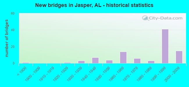
- New bridges - historical statistics
- 1Before 1900
- 11920-1929
- 31930-1939
- 71940-1949
- 41950-1959
- 141960-1969
- 61970-1979
- 31980-1989
- 411990-1999
- 152000-2009
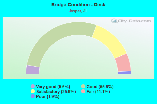
- Bridge Condition - Deck
- 5.6%Very good
- 55.6%Good
- 25.9%Satisfactory
- 11.1%Fair
- 1.9%Poor
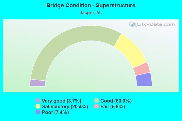
- Bridge Condition - Superstructure
- 3.7%Very good
- 63.0%Good
- 20.4%Satisfactory
- 5.6%Fair
- 7.4%Poor
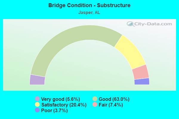
- Bridge Condition - Substructure
- 5.6%Very good
- 63.0%Good
- 20.4%Satisfactory
- 7.4%Fair
- 3.7%Poor
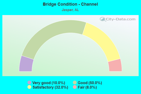
- Bridge Condition - Channel
- 10.0%Very good
- 50.0%Good
- 32.0%Satisfactory
- 8.0%Fair
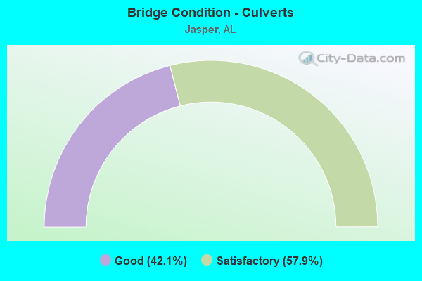
- Bridge Condition - Culverts
- 42.1%Good
- 57.9%Satisfactory
Find on map >> Show street view
Structure Number: 16323, Location: 0.5 Miles East AL-269 (Lat: 33.806942, Lng: -87.270569), Route carried "on" structure: Interstate 22, Year Built: 1998, Status: Open, Structure Length: 41.61m (136.52ft), Average Daily Traffic: 7,420 (year 2013), Truck Traffic: 20%, Average Future Daily Traffic: 10,053 (year 2041), Design Load: HS 20, Features Intersected: NS Railroad
Minimum Vertical Clearance: 30+ m (98+ ft), Kilometerpoint: 101.871, Lanes on structure: 2, Base Highway Network: Yes, Owner: State Highway Agency, Approaching Roadway Width: 18.3m (60.0ft), Skew: 9 degrees, Material/Design: Prestressed concrete, Design/Construction: Stringer/Multi-beam, Number Of Spans In Main Unit: 9, Number Of Approach Spans: 6, Length of Maximum Span: 30.8m (101.0ft), Curb-To-Curb Width: 17.1m (56.1ft), Out-to-Out Width: 17.9m (58.7ft)
Condition: Deck: Good, Superstructure: Good, Substructure: Good, Channel: Good, Operating Rating: 62.6 metric tons, Method Used To Determine Operating Rating: Load Factor (LF), Inventory Rating: 33.1 metric tons, Method Used To Determine Inventory Rating: Load Factor (LF), Structural Evaluation: Better than present minimum criteria, Deck Geometry: Superior to present desirable criteria, Underclear: High priority of corrective action, Waterway Adequacy: Equal to present desirable criteria, Approach Roadway Alignment: Equal to present desirable criteria, Length Of Structure Improvement: 41.61m (136.52ft), Designated Inspection Frequency: Every 24 months, Inspection Date: November 2021, Bridge Improvement Cost: $16,549,000, Roadway Improvement Cost: $1,655,000, Total Project Cost: $18,204,000 ( Estimate for 2022), Deck Structure Type: Concrete Cast-file-Place
Find on map >> Show street view
Structure Number: 16324, Location: Industrial Access Road (Lat: 33.793672, Lng: -87.239989), Route carried "on" structure: Interstate 22, Year Built: 1997, Status: Open, Structure Length: 6.95m (22.80ft), Average Daily Traffic: 9,515 (year 2013), Truck Traffic: 22%, Average Future Daily Traffic: 12,891 (year 2041), Design Load: HS 20, Features Intersected: Industrial Access Road
Minimum Vertical Clearance: 30+ m (98+ ft), Kilometerpoint: 105.200, Lanes on structure: 3, Lanes under structure: 2, Base Highway Network: Yes, Owner: State Highway Agency, Approaching Roadway Width: 17.1m (56.1ft), Skew: 2 degrees, Material/Design: Prestressed concrete, Design/Construction: Stringer/Multi-beam, Number Of Spans In Main Unit: 1, Number Of Approach Spans: 2, Length of Maximum Span: 34.7m (113.8ft), Curb-To-Curb Width: 17.1m (56.1ft), Out-to-Out Width: 18.0m (59.1ft)
Condition: Deck: Good, Superstructure: Good, Substructure: Good, Operating Rating: 71.1 metric tons, Method Used To Determine Operating Rating: Load Factor (LF), Inventory Rating: 26.9 metric tons, Method Used To Determine Inventory Rating: Load Factor (LF), Structural Evaluation: Equal to present minimum criteria, Deck Geometry: Equal to present minimum criteria, Underclear: Equal to present minimum criteria, Approach Roadway Alignment: Equal to present desirable criteria, Length Of Structure Improvement: 7.98m (26.18ft), Designated Inspection Frequency: Every 24 months, Inspection Date: April 2021, Bridge Improvement Cost: $3,230,000, Roadway Improvement Cost: $323,000, Total Project Cost: $3,553,000 ( Estimate for 2022), Deck Structure Type: Concrete Cast-file-Place
Find on map >> Show street view
Structure Number: 16325, Location: Industrial Access Road (Lat: 33.793992, Lng: -87.239933), Route carried "on" structure: Interstate 22, Year Built: 1997, Status: Open, Structure Length: 6.95m (22.80ft), Average Daily Traffic: 9,515 (year 2013), Truck Traffic: 22%, Average Future Daily Traffic: 12,891 (year 2041), Design Load: HS 20, Features Intersected: Industrial Access Road
Minimum Vertical Clearance: 30+ m (98+ ft), Kilometerpoint: 105.200, Lanes on structure: 2, Lanes under structure: 2, Base Highway Network: Yes, Owner: State Highway Agency, Approaching Roadway Width: 17.1m (56.1ft), Skew: 2 degrees, Material/Design: Prestressed concrete, Design/Construction: Stringer/Multi-beam, Number Of Spans In Main Unit: 1, Number Of Approach Spans: 2, Length of Maximum Span: 34.7m (113.8ft), Curb-To-Curb Width: 17.1m (56.1ft), Out-to-Out Width: 18.3m (60.0ft)
Condition: Deck: Good, Superstructure: Good, Substructure: Good, Operating Rating: 71.1 metric tons, Method Used To Determine Operating Rating: Load Factor (LF), Inventory Rating: 26.9 metric tons, Method Used To Determine Inventory Rating: Load Factor (LF), Structural Evaluation: Equal to present minimum criteria, Deck Geometry: Superior to present desirable criteria, Underclear: Equal to present minimum criteria, Approach Roadway Alignment: Equal to present desirable criteria, Length Of Structure Improvement: 7.98m (26.18ft), Designated Inspection Frequency: Every 24 months, Inspection Date: April 2021, Bridge Improvement Cost: $3,284,000, Roadway Improvement Cost: $328,000, Total Project Cost: $3,612,000 ( Estimate for 2022), Deck Structure Type: Concrete Cast-file-Place
Find on map >> Show street view
Structure Number: 16326, Location: Whitehouse Road (Lat: 33.800039, Lng: -87.253786), Route carried "on" structure: Alternate County highway , Year Built: 1996, Status: Open, Structure Length: 12.80m (41.99ft), Average Daily Traffic: 100 (year 2000), Average Future Daily Traffic: 200 (year 2041), Design Load: HS 20, Features Intersected: I-22, Facility Carried by Structure: Whitehouse Road
Minimum Vertical Clearance: 30+ m (98+ ft), Kilometerpoint: 0.000, Lanes on structure: 2, Lanes under structure: 4, Owner: State Highway Agency, Approaching Roadway Width: 8.4m (27.6ft), Skew: 2 degrees, Material/Design: Prestressed concrete, Design/Construction: Stringer/Multi-beam, Number Of Spans In Main Unit: 2, Number Of Approach Spans: 2, Length of Maximum Span: 39.6m (129.9ft), Curb-To-Curb Width: 10.4m (34.1ft), Out-to-Out Width: 10.9m (35.8ft)
Condition: Deck: Good, Superstructure: Good, Substructure: Good, Operating Rating: 74.3 metric tons, Method Used To Determine Operating Rating: Load Factor (LF), Inventory Rating: 39.8 metric tons, Method Used To Determine Inventory Rating: Load Factor (LF), Structural Evaluation: Better than present minimum criteria, Deck Geometry: Superior to present desirable criteria, Underclear: Equal to present minimum criteria, Approach Roadway Alignment: Equal to present minimum criteria, Length Of Structure Improvement: 13.63m (44.72ft), Designated Inspection Frequency: Every 24 months, Inspection Date: August 2021, Bridge Improvement Cost: $3,271,000, Roadway Improvement Cost: $327,000, Total Project Cost: $3,598,000 ( Estimate for 2022), Deck Structure Type: Concrete Cast-file-Place
Find on map >> Show street view
Structure Number: 16331, Location: I-22 Tuscaloosa Road (Lat: 33.811394, Lng: -87.298958), Route carried "on" structure: Interstate 22, Year Built: 1995, Status: Open, Structure Length: 6.40m (21.00ft), Average Daily Traffic: 7,630 (year 2013), Truck Traffic: 20%, Average Future Daily Traffic: 10,337 (year 2041), Design Load: HS 20, Features Intersected: Tuscaloosa Road
Minimum Vertical Clearance: 30+ m (98+ ft), Kilometerpoint: 99.231, Lanes on structure: 2, Lanes under structure: 2, Base Highway Network: Yes, Owner: State Highway Agency, Approaching Roadway Width: 12.2m (40.0ft), Skew: 1 degrees, Material/Design: Prestressed concrete, Design/Construction: Stringer/Multi-beam, Number Of Spans In Main Unit: 3, Length of Maximum Span: 24.4m (80.1ft), Curb-To-Curb Width: 12.2m (40.0ft), Out-to-Out Width: 13.0m (42.7ft)
Condition: Deck: Good, Superstructure: Good, Substructure: Good, Operating Rating: 68.9 metric tons, Method Used To Determine Operating Rating: Load Factor (LF), Inventory Rating: 38.2 metric tons, Method Used To Determine Inventory Rating: Load Factor (LF), Structural Evaluation: Better than present minimum criteria, Deck Geometry: Better than present minimum criteria, Underclear: Meets minimum limits, Approach Roadway Alignment: Equal to present desirable criteria, Length Of Structure Improvement: 7.44m (24.41ft), Designated Inspection Frequency: Every 24 months, Inspection Date: August 2021, Bridge Improvement Cost: $2,143,000, Roadway Improvement Cost: $214,000, Total Project Cost: $2,357,000 ( Estimate for 2022), Deck Structure Type: Concrete Cast-file-Place
Find on map >> Show street view
Structure Number: 16332, Location: I-22 Tuscaloosa Road (Lat: 33.811164, Lng: -87.299161), Route carried "on" structure: Interstate 22, Year Built: 1995, Status: Open, Structure Length: 6.40m (21.00ft), Average Daily Traffic: 7,630 (year 2013), Truck Traffic: 20%, Average Future Daily Traffic: 10,337 (year 2041), Design Load: HS 20, Features Intersected: Tuscaloosa Road
Minimum Vertical Clearance: 30+ m (98+ ft), Kilometerpoint: 99.231, Lanes on structure: 2, Lanes under structure: 2, Base Highway Network: Yes, Owner: State Highway Agency, Approaching Roadway Width: 12.2m (40.0ft), Skew: 1 degrees, Material/Design: Prestressed concrete, Design/Construction: Stringer/Multi-beam, Number Of Spans In Main Unit: 3, Length of Maximum Span: 24.4m (80.1ft), Curb-To-Curb Width: 12.2m (40.0ft), Out-to-Out Width: 13.0m (42.7ft)
Condition: Deck: Good, Superstructure: Good, Substructure: Good, Operating Rating: 68.9 metric tons, Method Used To Determine Operating Rating: Load Factor (LF), Inventory Rating: 38.2 metric tons, Method Used To Determine Inventory Rating: Load Factor (LF), Structural Evaluation: Better than present minimum criteria, Deck Geometry: Better than present minimum criteria, Underclear: Meets minimum limits, Approach Roadway Alignment: Equal to present desirable criteria, Length Of Structure Improvement: 7.44m (24.41ft), Designated Inspection Frequency: Every 24 months, Inspection Date: August 2021, Bridge Improvement Cost: $2,143,000, Roadway Improvement Cost: $214,000, Total Project Cost: $2,357,000 ( Estimate for 2022), Deck Structure Type: Concrete Cast-file-Place
Find on map >> Show street view
Structure Number: 16333, Location: BNSF Railroad (Lat: 33.810331, Lng: -87.294525), Route carried "on" structure: Interstate 22, Year Built: 1995, Status: Open, Structure Length: 13.41m (44.00ft), Average Daily Traffic: 7,630 (year 2013), Truck Traffic: 20%, Average Future Daily Traffic: 10,337 (year 2041), Design Load: HS 20, Features Intersected: BNSF Railroad
Minimum Vertical Clearance: 30+ m (98+ ft), Kilometerpoint: 99.715, Lanes on structure: 2, Base Highway Network: Yes, Owner: State Highway Agency, Approaching Roadway Width: 12.2m (40.0ft), Material/Design: Prestressed concrete, Design/Construction: Stringer/Multi-beam, Number Of Spans In Main Unit: 4, Length of Maximum Span: 33.5m (109.9ft), Curb-To-Curb Width: 12.2m (40.0ft), Out-to-Out Width: 13.1m (43.0ft)
Condition: Deck: Good, Superstructure: Good, Substructure: Good, Channel: Very good, Operating Rating: 76.7 metric tons, Method Used To Determine Operating Rating: Load Factor (LF), Inventory Rating: 42.3 metric tons, Method Used To Determine Inventory Rating: Load Factor (LF), Structural Evaluation: Better than present minimum criteria, Deck Geometry: Better than present minimum criteria, Underclear: Superior to present desirable criteria, Waterway Adequacy: Superior to present desirable criteria, Approach Roadway Alignment: Equal to present desirable criteria, Length Of Structure Improvement: 14.22m (46.65ft), Designated Inspection Frequency: Every 24 months, Inspection Date: Febuary 2021, Bridge Improvement Cost: $4,194,000, Roadway Improvement Cost: $419,000, Total Project Cost: $4,613,000 ( Estimate for 2022), Deck Structure Type: Concrete Cast-file-Place
Find on map >> Show street view
Structure Number: 16334, Location: BNSF Railroad (Lat: 33.810097, Lng: -87.294731), Route carried "on" structure: Interstate 22, Year Built: 1995, Status: Open, Structure Length: 13.41m (44.00ft), Average Daily Traffic: 7,630 (year 2013), Truck Traffic: 20%, Average Future Daily Traffic: 10,337 (year 2041), Design Load: HS 20, Features Intersected: BNSF Railroad
Minimum Vertical Clearance: 30+ m (98+ ft), Kilometerpoint: 99.715, Lanes on structure: 2, Base Highway Network: Yes, Owner: State Highway Agency, Approaching Roadway Width: 12.2m (40.0ft), Material/Design: Prestressed concrete, Design/Construction: Stringer/Multi-beam, Number Of Spans In Main Unit: 4, Length of Maximum Span: 33.5m (109.9ft), Curb-To-Curb Width: 12.2m (40.0ft), Out-to-Out Width: 13.1m (43.0ft)
Condition: Deck: Good, Superstructure: Good, Substructure: Good, Channel: Very good, Operating Rating: 76.7 metric tons, Method Used To Determine Operating Rating: Load Factor (LF), Inventory Rating: 42.3 metric tons, Method Used To Determine Inventory Rating: Load Factor (LF), Structural Evaluation: Better than present minimum criteria, Deck Geometry: Better than present minimum criteria, Underclear: Superior to present desirable criteria, Waterway Adequacy: Superior to present desirable criteria, Approach Roadway Alignment: Equal to present desirable criteria, Length Of Structure Improvement: 14.22m (46.65ft), Designated Inspection Frequency: Every 24 months, Inspection Date: Febuary 2021, Bridge Improvement Cost: $4,194,000, Roadway Improvement Cost: $419,000, Total Project Cost: $4,613,000 ( Estimate for 2022), Deck Structure Type: Concrete Cast-file-Place
Find on map >> Show street view
Structure Number: 16335, Location: I-22 @ Calumet Road (Lat: 33.809275, Lng: -87.290153), Route carried "on" structure: Interstate 22, Year Built: 1995, Status: Open, Structure Length: 5.49m (18.01ft), Average Daily Traffic: 7,630 (year 2013), Truck Traffic: 20%, Average Future Daily Traffic: 10,337 (year 2041), Design Load: HS 20, Features Intersected: Calumet Road
Minimum Vertical Clearance: 30+ m (98+ ft), Kilometerpoint: 100.196, Lanes on structure: 2, Lanes under structure: 2, Base Highway Network: Yes, Owner: State Highway Agency, Approaching Roadway Width: 12.2m (40.0ft), Material/Design: Prestressed concrete, Design/Construction: Stringer/Multi-beam, Number Of Spans In Main Unit: 1, Number Of Approach Spans: 2, Length of Maximum Span: 24.4m (80.1ft), Curb-To-Curb Width: 12.2m (40.0ft), Out-to-Out Width: 13.1m (43.0ft)
Condition: Deck: Good, Superstructure: Good, Substructure: Good, Operating Rating: 63.5 metric tons, Method Used To Determine Operating Rating: Load Factor (LF), Inventory Rating: 33.7 metric tons, Method Used To Determine Inventory Rating: Load Factor (LF), Structural Evaluation: Better than present minimum criteria, Deck Geometry: Better than present minimum criteria, Underclear: Superior to present desirable criteria, Approach Roadway Alignment: Equal to present desirable criteria, Length Of Structure Improvement: 6.52m (21.39ft), Designated Inspection Frequency: Every 24 months, Inspection Date: Febuary 2021, Bridge Improvement Cost: $1,923,000, Roadway Improvement Cost: $192,000, Total Project Cost: $2,115,000 ( Estimate for 2022), Deck Structure Type: Concrete Cast-file-Place
Find on map >> Show street view
Structure Number: 16336, Location: I-22 @ Calumet road (Lat: 33.809014, Lng: -87.290247), Route carried "on" structure: Interstate 22, Year Built: 1995, Status: Open, Structure Length: 5.49m (18.01ft), Average Daily Traffic: 7,630 (year 2013), Truck Traffic: 20%, Average Future Daily Traffic: 10,337 (year 2041), Design Load: HS 20, Features Intersected: Calumet Road
Minimum Vertical Clearance: 30+ m (98+ ft), Kilometerpoint: 100.196, Lanes on structure: 2, Lanes under structure: 2, Base Highway Network: Yes, Owner: State Highway Agency, Approaching Roadway Width: 12.2m (40.0ft), Material/Design: Prestressed concrete, Design/Construction: Stringer/Multi-beam, Number Of Spans In Main Unit: 1, Number Of Approach Spans: 2, Length of Maximum Span: 24.4m (80.1ft), Curb-To-Curb Width: 12.2m (40.0ft), Out-to-Out Width: 13.1m (43.0ft)
Condition: Deck: Good, Superstructure: Good, Substructure: Good, Operating Rating: 63.5 metric tons, Method Used To Determine Operating Rating: Load Factor (LF), Inventory Rating: 33.7 metric tons, Method Used To Determine Inventory Rating: Load Factor (LF), Structural Evaluation: Better than present minimum criteria, Deck Geometry: Better than present minimum criteria, Underclear: Superior to present desirable criteria, Approach Roadway Alignment: Equal to present desirable criteria, Length Of Structure Improvement: 6.52m (21.39ft), Designated Inspection Frequency: Every 24 months, Inspection Date: Febuary 2021, Bridge Improvement Cost: $1,922,000, Roadway Improvement Cost: $192,000, Total Project Cost: $2,114,000 ( Estimate for 2022), Deck Structure Type: Concrete Cast-file-Place
Find on map >> Show street view
Structure Number: 1642, Location: AL-269 @ I 22 (Lat: 33.806278, Lng: -87.279036), Route carried "on" structure: State highway 269, Year Built: 1995, Status: Open, Structure Length: 12.50m (41.01ft), Average Daily Traffic: 6,380 (year 2013), Truck Traffic: 14%, Average Future Daily Traffic: 7,785 (year 2041), Design Load: HS 20, Features Intersected: I-22
Minimum Vertical Clearance: 5.43m (17.81ft), Kilometerpoint: 63.730, Lanes on structure: 4, Lanes under structure: 4, Owner: State Highway Agency, Approaching Roadway Width: 29.3m (96.1ft), Skew: 20 degrees, Material/Design: Prestressed concrete, Design/Construction: Stringer/Multi-beam, Number Of Spans In Main Unit: 2, Number Of Approach Spans: 2, Length of Maximum Span: 42.7m (140.1ft), Curb-To-Curb Width: 29.9m (98.1ft), Out-to-Out Width: 30.8m (101.0ft)
Condition: Deck: Good, Superstructure: Good, Substructure: Good, Operating Rating: 48.0 metric tons, Method Used To Determine Operating Rating: Load Factor (LF), Inventory Rating: 32.8 metric tons, Method Used To Determine Inventory Rating: Load Factor (LF), Structural Evaluation: Better than present minimum criteria, Deck Geometry: Superior to present desirable criteria, Underclear: Equal to present minimum criteria, Approach Roadway Alignment: Equal to present desirable criteria, Length Of Structure Improvement: 13.33m (43.73ft), Designated Inspection Frequency: Every 24 months, Inspection Date: August 2021, Bridge Improvement Cost: $9,235,000, Roadway Improvement Cost: $924,000, Total Project Cost: $10,159,000 ( Estimate for 2022), Deck Structure Type: Concrete Cast-file-Place
Find on map >> Show street view
Structure Number: 16429, Location: .1 MI. W I-22 (Lat: 33.818911, Lng: -87.316311), Route carried "on" structure: State highway 69, Year Built: 1995, Status: Open, Structure Length: 6.86m (22.51ft), Average Daily Traffic: 4,480 (year 2013), Truck Traffic: 12%, Average Future Daily Traffic: 5,823 (year 2041), Design Load: HS 20, Features Intersected: Cane Creek
Minimum Vertical Clearance: 30+ m (98+ ft), Kilometerpoint: 319.484, Lanes on structure: 4, Owner: State Highway Agency, Approaching Roadway Width: 25.0m (82.0ft), Skew: 3 degrees, Material/Design: Prestressed concrete, Design/Construction: Stringer/Multi-beam, Number Of Spans In Main Unit: 3, Length of Maximum Span: 22.9m (75.1ft), Curb-To-Curb Width: 25.0m (82.0ft), Out-to-Out Width: 28.9m (94.8ft)
Condition: Deck: Good, Superstructure: Good, Substructure: Good, Channel: Satisfactory, Operating Rating: 69.6 metric tons, Method Used To Determine Operating Rating: Load Factor (LF), Inventory Rating: 52.5 metric tons, Method Used To Determine Inventory Rating: Load Factor (LF), Structural Evaluation: Better than present minimum criteria, Deck Geometry: Superior to present desirable criteria, Waterway Adequacy: Better than present minimum criteria, Approach Roadway Alignment: Equal to present desirable criteria, Length Of Structure Improvement: 7.90m (25.92ft), Designated Inspection Frequency: Every 24 months, Inspection Date: April 2021, Bridge Improvement Cost: $5,090,000, Roadway Improvement Cost: $509,000, Total Project Cost: $5,599,000 ( Estimate for 2022), Deck Structure Type: Concrete Cast-file-Place
Find on map >> Show street view
Structure Number: 16898, Location: I-22 over Holley Creek (Lat: 33.831622, Lng: -87.321067), Route carried "on" structure: Interstate 22, Year Built: 1996, Status: Open, Structure Length: 9.24m (30.31ft), Average Daily Traffic: 6,850 (year 2013), Truck Traffic: 20%, Average Future Daily Traffic: 9,280 (year 2041), Design Load: HS 20, Features Intersected: Holley Creek
Minimum Vertical Clearance: 30+ m (98+ ft), Kilometerpoint: 95.659, Lanes on structure: 2, Lanes under structure: 2, Base Highway Network: Yes, Owner: State Highway Agency, Approaching Roadway Width: 12.2m (40.0ft), Skew: 2 degrees, Material/Design: Prestressed concrete, Design/Construction: Stringer/Multi-beam, Number Of Spans In Main Unit: 3, Length of Maximum Span: 30.8m (101.0ft), Curb-To-Curb Width: 12.2m (40.0ft), Out-to-Out Width: 13.1m (43.0ft)
Condition: Deck: Good, Superstructure: Good, Substructure: Very good, Operating Rating: 63.6 metric tons, Method Used To Determine Operating Rating: Load Factor (LF), Inventory Rating: 38.1 metric tons, Method Used To Determine Inventory Rating: Load Factor (LF), Structural Evaluation: Better than present minimum criteria, Deck Geometry: Somewhat better than minimum adequacy, Underclear: Superior to present desirable criteria, Approach Roadway Alignment: Equal to present desirable criteria, Length Of Structure Improvement: 10.20m (33.46ft), Designated Inspection Frequency: Every 24 months, Inspection Date: March 2021, Bridge Improvement Cost: $3,007,000, Roadway Improvement Cost: $301,000, Total Project Cost: $3,308,000 ( Estimate for 2022), Deck Structure Type: Concrete Cast-file-Place
Find on map >> Show street view
Structure Number: 16899, Location: I-22 over Holley (Lat: 33.831711, Lng: -87.320739), Route carried "on" structure: Interstate 22, Year Built: 1996, Status: Open, Structure Length: 9.24m (30.31ft), Average Daily Traffic: 6,850 (year 2013), Truck Traffic: 20%, Average Future Daily Traffic: 9,280 (year 2041), Design Load: HS 20, Features Intersected: Holley Grove Road
Minimum Vertical Clearance: 30+ m (98+ ft), Kilometerpoint: 95.659, Lanes on structure: 2, Lanes under structure: 2, Base Highway Network: Yes, Owner: State Highway Agency, Approaching Roadway Width: 12.2m (40.0ft), Skew: 2 degrees, Material/Design: Prestressed concrete, Design/Construction: Stringer/Multi-beam, Number Of Spans In Main Unit: 3, Length of Maximum Span: 30.8m (101.0ft), Curb-To-Curb Width: 12.2m (40.0ft), Out-to-Out Width: 13.1m (43.0ft)
Condition: Deck: Good, Superstructure: Good, Substructure: Good, Operating Rating: 63.6 metric tons, Method Used To Determine Operating Rating: Load Factor (LF), Inventory Rating: 38.1 metric tons, Method Used To Determine Inventory Rating: Load Factor (LF), Structural Evaluation: Better than present minimum criteria, Deck Geometry: Better than present minimum criteria, Underclear: Superior to present desirable criteria, Approach Roadway Alignment: Equal to present desirable criteria, Length Of Structure Improvement: 10.20m (33.46ft), Designated Inspection Frequency: Every 24 months, Inspection Date: March 2021, Bridge Improvement Cost: $3,007,000, Roadway Improvement Cost: $301,000, Total Project Cost: $3,308,000 ( Estimate for 2022), Deck Structure Type: Concrete Cast-file-Place
Find on map >> Show street view
Structure Number: 16901, Location: Moon Road (MP 58 on I-22) (Lat: 33.839703, Lng: -87.331322), Route carried "on" structure: County highway , Year Built: 1997, Status: Open, Structure Length: 10.79m (35.40ft), Average Daily Traffic: 200 (year 2001), Truck Traffic: 1%, Average Future Daily Traffic: 500 (year 2041), Design Load: HS 20, Features Intersected: I-22, Facility Carried by Structure: Moon Road
Minimum Vertical Clearance: 30+ m (98+ ft), Kilometerpoint: 0.000, Lanes on structure: 2, Lanes under structure: 4, Owner: State Highway Agency, Approaching Roadway Width: 10.4m (34.1ft), Skew: 1 degrees, Material/Design: Prestressed concrete, Design/Construction: Stringer/Multi-beam, Number Of Spans In Main Unit: 4, Length of Maximum Span: 35.1m (115.2ft), Curb-To-Curb Width: 10.4m (34.1ft), Out-to-Out Width: 11.2m (36.7ft)
Condition: Deck: Good, Superstructure: Good, Substructure: Good, Operating Rating: 60.1 metric tons, Method Used To Determine Operating Rating: Load Factor (LF), Inventory Rating: 37.8 metric tons, Method Used To Determine Inventory Rating: Load Factor (LF), Structural Evaluation: Better than present minimum criteria, Deck Geometry: Better than present minimum criteria, Underclear: Equal to present minimum criteria, Approach Roadway Alignment: Equal to present desirable criteria, Length Of Structure Improvement: 11.69m (38.35ft), Designated Inspection Frequency: Every 24 months, Inspection Date: March 2021, Bridge Improvement Cost: $2,885,000, Roadway Improvement Cost: $289,000, Total Project Cost: $3,174,000 ( Estimate for 2022), Deck Structure Type: Concrete Cast-file-Place
Find on map >> Show street view
Structure Number: 16902, Location: 0.2 MI W Moon Road (Lat: 33.841883, Lng: -87.333889), Route carried "on" structure: Interstate 22, Year Built: 1996, Status: Open, Structure Length: 1.52m (4.99ft), Average Daily Traffic: 13,700 (year 2013), Truck Traffic: 20%, Average Future Daily Traffic: 18,561 (year 2041), Design Load: HS 20, Features Intersected: Cane Creek
Minimum Vertical Clearance: 30+ m (98+ ft), Kilometerpoint: 94.052, Lanes on structure: 4, Base Highway Network: Yes, Owner: State Highway Agency, Approaching Roadway Width: 25.6m (84.0ft), Skew: 3 degrees, Material/Design: Concrete, Design/Construction: Culvert, Number Of Spans In Main Unit: 4, Length of Maximum Span: 3.0m (9.8ft)
Condition: Channel: Satisfactory, Culverts: Satisfactory, Operating Rating: 88.9 metric tons, Method Used To Determine Operating Rating: Load Factor (LF), Inventory Rating: 88.9 metric tons, Method Used To Determine Inventory Rating: Load Factor (LF), Structural Evaluation: Equal to present minimum criteria, Waterway Adequacy: Better than present minimum criteria, Approach Roadway Alignment: Equal to present desirable criteria, Length Of Structure Improvement: 2.20m (7.22ft), Designated Inspection Frequency: Every 24 months, Inspection Date: August 2021, Bridge Improvement Cost: $8,196,000, Roadway Improvement Cost: $820,000, Total Project Cost: $9,016,000 ( Estimate for 2022), Deck Structure Type: Concrete Cast-file-Place, Wearing Surface/Protective System: Wearing Surface: Bituminous
Find on map >> Show street view
Structure Number: 16903, Location: Frontage Rd MP 57.4 (Lat: 33.852711, Lng: -87.345303), Route carried "on" structure: ServiceOther road , Year Built: 1996, Status: Open, Structure Length: 14.60m (47.90ft), Average Daily Traffic: 200 (year 2001), Truck Traffic: 20%, Average Future Daily Traffic: 400 (year 2041), Design Load: HS 20, Features Intersected: I-22, Facility Carried by Structure: South Frontage Rd
Minimum Vertical Clearance: 30+ m (98+ ft), Kilometerpoint: 0.000, Lanes on structure: 2, Lanes under structure: 5, Owner: State Highway Agency, Approaching Roadway Width: 10.4m (34.1ft), Skew: 2 degrees, Material/Design: Prestressed concrete, Design/Construction: Stringer/Multi-beam, Number Of Spans In Main Unit: 5, Length of Maximum Span: 35.1m (115.2ft), Curb-To-Curb Width: 10.4m (34.1ft), Out-to-Out Width: 11.2m (36.7ft)
Condition: Deck: Good, Superstructure: Good, Substructure: Good, Operating Rating: 45.4 metric tons, Method Used To Determine Operating Rating: Load Factor (LF), Inventory Rating: 29.3 metric tons, Method Used To Determine Inventory Rating: Load Factor (LF), Structural Evaluation: Better than present minimum criteria, Deck Geometry: Better than present minimum criteria, Underclear: Equal to present minimum criteria, Approach Roadway Alignment: Better than present minimum criteria, Length Of Structure Improvement: 15.38m (50.46ft), Designated Inspection Frequency: Every 24 months, Inspection Date: March 2021, Bridge Improvement Cost: $3,797,000, Roadway Improvement Cost: $380,000, Total Project Cost: $4,177,000 ( Estimate for 2022), Deck Structure Type: Concrete Cast-file-Place
Find on map >> Show street view
Structure Number: 16904, Location: Jasper Interchange (Lat: 33.854697, Lng: -87.347189), Route carried "on" structure: Interstate 22, Year Built: 1996, Status: Open, Structure Length: 10.52m (34.51ft), Average Daily Traffic: 6,850 (year 2013), Truck Traffic: 20%, Average Future Daily Traffic: 9,280 (year 2041), Design Load: HS 20, Features Intersected: I-22
Minimum Vertical Clearance: 30+ m (98+ ft), Kilometerpoint: 92.281, Lanes on structure: 2, Lanes under structure: 4, Base Highway Network: Yes, Owner: State Highway Agency, Approaching Roadway Width: 15.8m (51.8ft), Skew: 2 degrees, Material/Design: Prestressed concrete, Design/Construction: Stringer/Multi-beam, Number Of Spans In Main Unit: 4, Length of Maximum Span: 30.5m (100.1ft), Curb-To-Curb Width: 15.8m (51.8ft), Out-to-Out Width: 16.7m (54.8ft)
Condition: Deck: Good, Superstructure: Good, Substructure: Good, Operating Rating: 53.1 metric tons, Method Used To Determine Operating Rating: Load Factor (LF), Inventory Rating: 33.8 metric tons, Method Used To Determine Inventory Rating: Load Factor (LF), Structural Evaluation: Better than present minimum criteria, Deck Geometry: Superior to present desirable criteria, Underclear: Equal to present minimum criteria, Approach Roadway Alignment: Equal to present desirable criteria, Length Of Structure Improvement: 11.43m (37.50ft), Designated Inspection Frequency: Every 24 months, Inspection Date: Febuary 2021, Bridge Improvement Cost: $4,231,000, Roadway Improvement Cost: $423,000, Total Project Cost: $4,654,000 ( Estimate for 2022), Deck Structure Type: Concrete Cast-file-Place
Find on map >> Show street view
Structure Number: 16905, Location: Jasper Interchange (Lat: 33.854842, Lng: -87.346831), Route carried "on" structure: Interstate 22, Year Built: 1996, Status: Open, Structure Length: 10.52m (34.51ft), Average Daily Traffic: 6,850 (year 2013), Truck Traffic: 20%, Average Future Daily Traffic: 9,280 (year 2041), Design Load: HS 20, Features Intersected: I-22
Minimum Vertical Clearance: 30+ m (98+ ft), Kilometerpoint: 92.281, Lanes on structure: 2, Lanes under structure: 4, Base Highway Network: Yes, Owner: State Highway Agency, Approaching Roadway Width: 16.5m (54.1ft), Skew: 2 degrees, Material/Design: Prestressed concrete, Design/Construction: Stringer/Multi-beam, Number Of Spans In Main Unit: 4, Length of Maximum Span: 30.5m (100.1ft), Curb-To-Curb Width: 15.8m (51.8ft), Out-to-Out Width: 16.7m (54.8ft)
Condition: Deck: Good, Superstructure: Good, Substructure: Good, Operating Rating: 51.5 metric tons, Method Used To Determine Operating Rating: Load Factor (LF), Inventory Rating: 32.9 metric tons, Method Used To Determine Inventory Rating: Load Factor (LF), Structural Evaluation: Better than present minimum criteria, Deck Geometry: Superior to present desirable criteria, Underclear: Equal to present minimum criteria, Approach Roadway Alignment: Equal to present desirable criteria, Length Of Structure Improvement: 11.42m (37.47ft), Designated Inspection Frequency: Every 24 months, Inspection Date: Febuary 2021, Bridge Improvement Cost: $4,230,000, Roadway Improvement Cost: $423,000, Total Project Cost: $4,653,000 ( Estimate for 2022), Deck Structure Type: Concrete Cast-file-Place
Find on map >> Show street view
Structure Number: 17036, Location: I-22 over AL-69 (Lat: 33.819436, Lng: -87.312878), Route carried "on" structure: Interstate 22, Year Built: 1995, Status: Open, Structure Length: 7.92m (25.98ft), Average Daily Traffic: 7,630 (year 2013), Truck Traffic: 20%, Average Future Daily Traffic: 10,337 (year 2041), Design Load: HS 20, Features Intersected: AL-69
Minimum Vertical Clearance: 30+ m (98+ ft), Kilometerpoint: 97.623, Lanes on structure: 2, Lanes under structure: 2, Base Highway Network: Yes, Owner: State Highway Agency, Approaching Roadway Width: 12.8m (42.0ft), Skew: 1 degrees, Material/Design: Prestressed concrete, Design/Construction: Stringer/Multi-beam, Number Of Spans In Main Unit: 1, Number Of Approach Spans: 2, Length of Maximum Span: 33.5m (109.9ft), Curb-To-Curb Width: 12.2m (40.0ft), Out-to-Out Width: 13.0m (42.7ft)
Condition: Deck: Good, Superstructure: Good, Substructure: Good, Operating Rating: 62.9 metric tons, Method Used To Determine Operating Rating: Load Factor (LF), Inventory Rating: 43.1 metric tons, Method Used To Determine Inventory Rating: Load Factor (LF), Structural Evaluation: Better than present minimum criteria, Deck Geometry: Better than present minimum criteria, Underclear: Equal to present minimum criteria, Approach Roadway Alignment: Equal to present desirable criteria, Length Of Structure Improvement: 8.94m (29.33ft), Designated Inspection Frequency: Every 24 months, Inspection Date: June 2021, Bridge Improvement Cost: $2,573,000, Roadway Improvement Cost: $257,000, Total Project Cost: $2,830,000 ( Estimate for 2022), Deck Structure Type: Concrete Cast-file-Place
Find on map >> Show street view
Structure Number: 17037, Location: I-22 over AL-69 (Lat: 33.819397, Lng: -87.313181), Route carried "on" structure: Interstate 22, Year Built: 1996, Status: Open, Structure Length: 7.92m (25.98ft), Average Daily Traffic: 7,630 (year 2013), Truck Traffic: 20%, Average Future Daily Traffic: 10,337 (year 2041), Design Load: HS 20, Features Intersected: AL-69
Minimum Vertical Clearance: 30+ m (98+ ft), Kilometerpoint: 97.623, Lanes on structure: 2, Lanes under structure: 2, Base Highway Network: Yes, Owner: State Highway Agency, Approaching Roadway Width: 12.8m (42.0ft), Skew: 1 degrees, Material/Design: Prestressed concrete, Design/Construction: Stringer/Multi-beam, Number Of Spans In Main Unit: 1, Number Of Approach Spans: 2, Length of Maximum Span: 33.5m (109.9ft), Curb-To-Curb Width: 12.2m (40.0ft), Out-to-Out Width: 13.1m (43.0ft)
Condition: Deck: Good, Superstructure: Good, Substructure: Good, Operating Rating: 62.9 metric tons, Method Used To Determine Operating Rating: Load Factor (LF), Inventory Rating: 43.1 metric tons, Method Used To Determine Inventory Rating: Load Factor (LF), Structural Evaluation: Better than present minimum criteria, Deck Geometry: Better than present minimum criteria, Underclear: Equal to present minimum criteria, Approach Roadway Alignment: Equal to present desirable criteria, Length Of Structure Improvement: 8.93m (29.30ft), Designated Inspection Frequency: Every 24 months, Inspection Date: June 2021, Bridge Improvement Cost: $2,632,000, Roadway Improvement Cost: $263,000, Total Project Cost: $2,895,000 ( Estimate for 2022), Deck Structure Type: Concrete Cast-file-Place
Find on map >> Show street view
Structure Number: 17214, Location: B * N RR (Lat: 33.814792, Lng: -87.232958), Route carried "on" structure: State highway , Year Built: 2001, Status: Open, Structure Length: 5.79m (19.00ft), Average Daily Traffic: 8,390 (year 2021), Truck Traffic: 34%, Average Future Daily Traffic: 16,690 (year 2041), Design Load: HS 20, Features Intersected: B*N RR, Facility Carried by Structure: INDUSTRIAL ACCESS
Minimum Vertical Clearance: 30+ m (98+ ft), Kilometerpoint: 3.219, Lanes on structure: 4, Owner: City or Municipal Highway Agency, Approaching Roadway Width: 25.0m (82.0ft), Skew: 2 degrees, Material/Design: Prestressed concrete, Design/Construction: Stringer/Multi-beam, Number Of Spans In Main Unit: 3, Length of Maximum Span: 21.3m (69.9ft), Curb-To-Curb Width: 25.0m (82.0ft), Out-to-Out Width: 25.6m (84.0ft)
Condition: Deck: Good, Superstructure: Good, Substructure: Satisfactory, Operating Rating: 83.0 metric tons, Method Used To Determine Operating Rating: Load Factor (LF), Inventory Rating: 47.3 metric tons, Method Used To Determine Inventory Rating: Load Factor (LF), Structural Evaluation: Equal to present minimum criteria, Deck Geometry: Superior to present desirable criteria, Underclear: High priority of corrective action, Approach Roadway Alignment: Equal to present desirable criteria, Length Of Structure Improvement: 6.83m (22.41ft), Designated Inspection Frequency: Every 24 months, Inspection Date: December 2021, Bridge Improvement Cost: $3,933,000, Roadway Improvement Cost: $393,000, Total Project Cost: $4,326,000 ( Estimate for 2022), Deck Structure Type: Concrete Cast-file-Place
Find on map >> Show street view
Structure Number: 17251, Location: AL-102 over I-22 (Lat: 33.863600, Lng: -87.413467), Route carried "on" structure: Alternate State highway 102, Year Built: 2000, Status: Open, Structure Length: 11.89m (39.01ft), Average Daily Traffic: 2,040 (year 2003), Truck Traffic: 12%, Average Future Daily Traffic: 3,030 (year 2041), Design Load: HS 20, Features Intersected: I-22
Minimum Vertical Clearance: 7.56m (24.80ft), Kilometerpoint: 0.000, Lanes on structure: 2, Lanes under structure: 4, Owner: State Highway Agency, Approaching Roadway Width: 25.0m (82.0ft), Material/Design: Prestressed concrete, Design/Construction: Stringer/Multi-beam, Number Of Spans In Main Unit: 4, Length of Maximum Span: 35.1m (115.2ft), Curb-To-Curb Width: 25.0m (82.0ft), Out-to-Out Width: 25.8m (84.6ft)
Condition: Deck: Satisfactory, Superstructure: Satisfactory, Substructure: Good, Operating Rating: 65.1 metric tons, Method Used To Determine Operating Rating: Load Factor (LF), Inventory Rating: 40.0 metric tons, Method Used To Determine Inventory Rating: Load Factor (LF), Structural Evaluation: Equal to present minimum criteria, Deck Geometry: Superior to present desirable criteria, Underclear: Equal to present minimum criteria, Approach Roadway Alignment: Equal to present desirable criteria, Length Of Structure Improvement: 12.75m (41.83ft), Designated Inspection Frequency: Every 24 months, Inspection Date: September 2021, Bridge Improvement Cost: $7,343,000, Roadway Improvement Cost: $734,000, Total Project Cost: $8,077,000 ( Estimate for 2022), Deck Structure Type: Concrete Cast-file-Place
Find on map >> Show street view
Structure Number: 17252, Location: .6 MI W Blackwell Rd (Lat: 33.863511, Lng: -87.404147), Route carried "on" structure: Interstate 22, Year Built: 2000, Status: Open, Structure Length: 0.96m (3.15ft), Average Daily Traffic: 19,700 (year 2013), Truck Traffic: 24%, Average Future Daily Traffic: 26,690 (year 2041), Design Load: HS 20, Features Intersected: Paul Creek
Minimum Vertical Clearance: 7.56m (24.80ft), Kilometerpoint: 86.905, Lanes on structure: 6, Base Highway Network: Yes, Owner: State Highway Agency, Approaching Roadway Width: 28.0m (91.9ft), Skew: 4 degrees, Material/Design: Concrete, Design/Construction: Culvert, Number Of Spans In Main Unit: 2, Length of Maximum Span: 4.8m (15.7ft)
Condition: Channel: Good, Culverts: Good, Operating Rating: 88.9 metric tons, Method Used To Determine Operating Rating: Load Factor (LF), Inventory Rating: 88.9 metric tons, Method Used To Determine Inventory Rating: Load Factor (LF), Structural Evaluation: Better than present minimum criteria, Waterway Adequacy: Equal to present minimum criteria, Approach Roadway Alignment: Better than present minimum criteria, Length Of Structure Improvement: 1.63m (5.35ft), Designated Inspection Frequency: Every 24 months, Inspection Date: August 2021, Bridge Improvement Cost: $4,230,000, Roadway Improvement Cost: $423,000, Total Project Cost: $4,653,000 ( Estimate for 2022)
Find on map >> Show street view
Structure Number: 17253, Location: .4 MI W. Blackwell Rd (Lat: 33.863247, Lng: -87.400667), Route carried "on" structure: Interstate 22, Year Built: 2000, Status: Open, Structure Length: 0.77m (2.53ft), Average Daily Traffic: 19,700 (year 2013), Truck Traffic: 24%, Average Future Daily Traffic: 26,690 (year 2041), Design Load: HS 20, Features Intersected: Cold Branch
Minimum Vertical Clearance: 7.56m (24.80ft), Kilometerpoint: 87.066, Lanes on structure: 6, Base Highway Network: Yes, Owner: State Highway Agency, Approaching Roadway Width: 28.0m (91.9ft), Skew: 4 degrees, Material/Design: Concrete, Design/Construction: Culvert, Number Of Spans In Main Unit: 2, Length of Maximum Span: 3.9m (12.8ft)
Condition: Channel: Good, Culverts: Satisfactory, Operating Rating: 88.9 metric tons, Method Used To Determine Operating Rating: Load Factor (LF), Inventory Rating: 88.9 metric tons, Method Used To Determine Inventory Rating: Load Factor (LF), Structural Evaluation: Equal to present minimum criteria, Waterway Adequacy: Equal to present minimum criteria, Approach Roadway Alignment: Equal to present desirable criteria, Length Of Structure Improvement: 1.42m (4.66ft), Designated Inspection Frequency: Every 24 months, Inspection Date: August 2021, Bridge Improvement Cost: $3,987,000, Roadway Improvement Cost: $399,000, Total Project Cost: $4,386,000 ( Estimate for 2022)
Find on map >> Show street view
Structure Number: 17255, Location: 2.7 Miles W Jasper Int (Lat: 33.862258, Lng: -87.393536), Route carried "on" structure: Interstate 22, Year Built: 2000, Status: Open, Structure Length: 6.84m (22.44ft), Average Daily Traffic: 9,850 (year 2013), Truck Traffic: 24%, Average Future Daily Traffic: 13,345 (year 2040), Design Load: HS 20, Features Intersected: Blackwell Rd
Minimum Vertical Clearance: 23.64m (77.56ft), Kilometerpoint: 88.836, Lanes on structure: 3, Lanes under structure: 2, Base Highway Network: Yes, Owner: State Highway Agency, Approaching Roadway Width: 17.0m (55.8ft), Material/Design: Prestressed concrete, Design/Construction: Stringer/Multi-beam, Number Of Spans In Main Unit: 3, Length of Maximum Span: 32.0m (105.0ft), Curb-To-Curb Width: 17.1m (56.1ft), Out-to-Out Width: 17.9m (58.7ft)
Condition: Deck: Good, Superstructure: Good, Substructure: Good, Operating Rating: 63.8 metric tons, Method Used To Determine Operating Rating: Load Factor (LF), Inventory Rating: 43.2 metric tons, Method Used To Determine Inventory Rating: Load Factor (LF), Structural Evaluation: Better than present minimum criteria, Deck Geometry: Equal to present minimum criteria, Underclear: Superior to present desirable criteria, Approach Roadway Alignment: Equal to present desirable criteria, Length Of Structure Improvement: 7.88m (25.85ft), Designated Inspection Frequency: Every 24 months, Inspection Date: October 2020, Bridge Improvement Cost: $3,132,000, Roadway Improvement Cost: $313,000, Total Project Cost: $3,445,000 ( Estimate for 2022), Deck Structure Type: Concrete Cast-file-Place
Find on map >> Show street view
Structure Number: 17256, Location: .8 MI E Blackwell Rd (Lat: 33.858747, Lng: -87.378397), Route carried "on" structure: Interstate 22, Year Built: 2000, Status: Open, Structure Length: 0.76m (2.49ft), Average Daily Traffic: 19,700 (year 2013), Truck Traffic: 24%, Average Future Daily Traffic: 26,690 (year 2041), Design Load: HS 20, Features Intersected: Burton Creek
Minimum Vertical Clearance: 7.56m (24.80ft), Kilometerpoint: 90.123, Lanes on structure: 6, Base Highway Network: Yes, Owner: State Highway Agency, Approaching Roadway Width: 28.0m (91.9ft), Skew: 4 degrees, Material/Design: Concrete, Design/Construction: Culvert, Number Of Spans In Main Unit: 2, Length of Maximum Span: 3.7m (12.1ft)
Condition: Channel: Satisfactory, Culverts: Good, Operating Rating: 88.9 metric tons, Method Used To Determine Operating Rating: Load Factor (LF), Inventory Rating: 88.9 metric tons, Method Used To Determine Inventory Rating: Load Factor (LF), Structural Evaluation: Better than present minimum criteria, Waterway Adequacy: Equal to present desirable criteria, Approach Roadway Alignment: Equal to present desirable criteria, Length Of Structure Improvement: 1.41m (4.63ft), Designated Inspection Frequency: Every 24 months, Inspection Date: August 2021, Bridge Improvement Cost: $4,367,000, Roadway Improvement Cost: $437,000, Total Project Cost: $4,804,000 ( Estimate for 2022)
Find on map >> Show street view
Structure Number: 17774, Location: .5 MI W. East Lake Rd (Lat: 33.790925, Lng: -87.230850), Route carried "on" structure: Interstate 22, Year Built: 2002, Status: Open, Structure Length: 1.34m (4.40ft), Average Daily Traffic: 19,030 (year 2013), Truck Traffic: 22%, Average Future Daily Traffic: 25,783 (year 2041), Design Load: HS 20, Features Intersected: Flat Branch
Minimum Vertical Clearance: 30+ m (98+ ft), Kilometerpoint: 106.136, Lanes on structure: 6, Base Highway Network: Yes, Owner: State Highway Agency, Approaching Roadway Width: 29.3m (96.1ft), Skew: 1 degrees, Material/Design: Concrete, Design/Construction: Culvert, Number Of Spans In Main Unit: 4, Length of Maximum Span: 3.0m (9.8ft)
Condition: Channel: Satisfactory, Culverts: Satisfactory, Operating Rating: 88.9 metric tons, Method Used To Determine Operating Rating: Load Factor (LF), Inventory Rating: 88.9 metric tons, Method Used To Determine Inventory Rating: Load Factor (LF), Structural Evaluation: Equal to present minimum criteria, Waterway Adequacy: Better than present minimum criteria, Approach Roadway Alignment: Equal to present desirable criteria, Length Of Structure Improvement: 2.01m (6.59ft), Designated Inspection Frequency: Every 24 months, Inspection Date: August 2021, Bridge Improvement Cost: $5,134,000, Roadway Improvement Cost: $513,000, Total Project Cost: $5,647,000 ( Estimate for 2022)
Find on map >> Show street view
Structure Number: 18013, Location: AL-69 @ Blackwater Creek (Lat: 33.884678, Lng: -87.161450), Route carried "on" structure: State highway 69, Year Built: 2008, Status: Open, Structure Length: 37.03m (121.49ft), Average Daily Traffic: 5,635 (year 2020), Truck Traffic: 8%, Average Future Daily Traffic: 6,499 (year 2040), Design Load: HS 20, Features Intersected: Blackwater Creek
Minimum Vertical Clearance: 30+ m (98+ ft), Kilometerpoint: 340.473, Lanes on structure: 2, Owner: State Highway Agency, Approaching Roadway Width: 13.4m (44.0ft), Skew: 1 degrees, Material/Design: Prestressed concrete, Design/Construction: Stringer/Multi-beam, Number Of Spans In Main Unit: 9, Length of Maximum Span: 41.5m (136.2ft), Curb-To-Curb Width: 13.4m (44.0ft), Out-to-Out Width: 14.3m (46.9ft)
Condition: Deck: Good, Superstructure: Good, Substructure: Good, Channel: Good, Operating Rating: 64.7 metric tons, Method Used To Determine Operating Rating: Load Factor (LF), Inventory Rating: 38.7 metric tons, Method Used To Determine Inventory Rating: Load Factor (LF), Structural Evaluation: Better than present minimum criteria, Deck Geometry: Equal to present minimum criteria, Waterway Adequacy: Superior to present desirable criteria, Approach Roadway Alignment: Equal to present desirable criteria, Length Of Structure Improvement: 37.03m (121.49ft), Designated Inspection Frequency: Every 24 months, Inspection Date: September 2020, Bridge Improvement Cost: $11,681,000, Roadway Improvement Cost: $1,168,000, Total Project Cost: $12,849,000 ( Estimate for 2022), Deck Structure Type: Concrete Cast-file-Place
Find on map >> Show street view
Structure Number: 18173, Location: West of Cordova (Lat: 33.789317, Lng: -87.221675), Route carried "on" structure: County highway , Year Built: 2002, Status: Open, Structure Length: 10.36m (33.99ft), Average Daily Traffic: 1,167 (year 2020), Truck Traffic: 10%, Average Future Daily Traffic: 1,400 (year 2040), Design Load: HS 20, Features Intersected: I-22, Facility Carried by Structure: East Lake Rd
Minimum Vertical Clearance: 30+ m (98+ ft), Kilometerpoint: 0.000, Lanes on structure: 2, Lanes under structure: 6, Owner: State Highway Agency, Approaching Roadway Width: 6.1m (20.0ft), Skew: 1 degrees, Material/Design: Prestressed concrete, Design/Construction: Stringer/Multi-beam, Number Of Spans In Main Unit: 4, Length of Maximum Span: 36.6m (120.1ft), Curb-To-Curb Width: 8.5m (27.9ft), Out-to-Out Width: 9.4m (30.8ft)
Condition: Deck: Good, Superstructure: Good, Substructure: Good, Operating Rating: 86.5 metric tons, Method Used To Determine Operating Rating: Load Factor (LF), Inventory Rating: 35.6 metric tons, Method Used To Determine Inventory Rating: Load Factor (LF), Structural Evaluation: Better than present minimum criteria, Deck Geometry: Somewhat better than minimum adequacy, Underclear: Better than present minimum criteria, Approach Roadway Alignment: Equal to present desirable criteria, Length Of Structure Improvement: 11.28m (37.01ft), Designated Inspection Frequency: Every 24 months, Inspection Date: August 2021, Bridge Improvement Cost: $2,320,000, Roadway Improvement Cost: $232,000, Total Project Cost: $2,552,000 ( Estimate for 2022), Deck Structure Type: Concrete Cast-file-Place
Find on map >> Show street view
Structure Number: 18722, Location: 1 MILE EAST FALL CITY RD (Lat: 33.950000, Lng: -87.283333), Route carried "on" structure: County highway , Year Built: 2002, Status: Open, Structure Length: 0.91m (2.99ft), Average Daily Traffic: 150 (year 2002), Truck Traffic: 3%, Average Future Daily Traffic: 250 (year 2033), Features Intersected: LAYS ROAD, Facility Carried by Structure: SPRING CREEK
Minimum Vertical Clearance: 30+ m (98+ ft), Kilometerpoint: 0.010, Lanes on structure: 2, Owner: County Highway Agency, Approaching Roadway Width: 6.1m (20.0ft), Material/Design: Steel, Design/Construction: Stringer/Multi-beam, Number Of Spans In Main Unit: 1, Length of Maximum Span: 9.1m (29.9ft), Curb-To-Curb Width: 6.1m (20.0ft), Out-to-Out Width: 6.1m (20.0ft)
Condition: Deck: Very good, Superstructure: Good, Substructure: Fair, Channel: Satisfactory, Operating Rating: 63.9 metric tons, Method Used To Determine Operating Rating: Load Factor (LF), Inventory Rating: 38.3 metric tons, Method Used To Determine Inventory Rating: Load Factor (LF), Structural Evaluation: Somewhat better than minimum adequacy, Deck Geometry: Meets minimum limits, Waterway Adequacy: Equal to present minimum criteria, Approach Roadway Alignment: Equal to present minimum criteria, Length Of Structure Improvement: 1.59m (5.22ft), Designated Inspection Frequency: Every 24 months, Inspection Date: October 2021, Bridge Improvement Cost: $217,000, Roadway Improvement Cost: $22,000, Total Project Cost: $239,000 ( Estimate for 2022), Deck Structure Type: Concrete Cast-file-Place
Find on map >> Show street view
Structure Number: 20291, Location: 2 MILES NORTH OF HWY 5 (Lat: 33.916667, Lng: -87.333333), Route carried "on" structure: County highway , Year Built: 2009, Status: Open, Structure Length: 3.96m (12.99ft), Average Daily Traffic: 350 (year 2009), Truck Traffic: 5%, Average Future Daily Traffic: 550 (year 2031), Design Load: HS 20, Features Intersected: BLACKWATER CREEK, Facility Carried by Structure: JOHNSEY BRIDGE RD
Minimum Vertical Clearance: 30+ m (98+ ft), Kilometerpoint: 0.010, Lanes on structure: 2, Owner: County Highway Agency, Approaching Roadway Width: 7.3m (24.0ft), Material/Design: Steel continuous, Design/Construction: Truss - Thru, Number Of Spans In Main Unit: 1, Length of Maximum Span: 39.6m (129.9ft), Curb-To-Curb Width: 7.3m (24.0ft), Out-to-Out Width: 7.6m (24.9ft)
Condition: Deck: Very good, Superstructure: Very good, Substructure: Very good, Channel: Very good, Operating Rating: 42.3 metric tons, Method Used To Determine Operating Rating: Load Factor (LF), Inventory Rating: 25.4 metric tons, Method Used To Determine Inventory Rating: Load Factor (LF), Structural Evaluation: Equal to present minimum criteria, Deck Geometry: Somewhat better than minimum adequacy, Waterway Adequacy: Equal to present desirable criteria, Approach Roadway Alignment: Somewhat better than minimum adequacy, Length Of Structure Improvement: 4.91m (16.11ft), Designated Inspection Frequency: Every 24 months, Critical Feature Inspection Frequency: Every 24 months, Inspection Date: April 2021, Critical Feature Inspection Date: April 2021, Bridge Improvement Cost: $842,000, Roadway Improvement Cost: $84,000, Total Project Cost: $926,000 ( Estimate for 2022), Deck Structure Type: Corrugated Steel, Wearing Surface/Protective System: Wearing Surface: Bituminous, Deck Protection: Galvanized Reinforcing
Find on map >> Show street view
Structure Number: 21532, Location: _ (Lat: 33.910147, Lng: -87.299719), Route carried "on" structure: County highway 270, Year Built: 1990, Status: Open, Structure Length: 0.94m (3.08ft), Average Daily Traffic: 1,490 (year 2019), Truck Traffic: 5%, Average Future Daily Traffic: 1,816 (year 2029), Design Load: HS 20, Features Intersected: _STRIP PIT CREEK, Facility Carried by Structure: __CR 27
Minimum Vertical Clearance: 30+ m (98+ ft), Kilometerpoint: 0.401, Lanes on structure: 2, Owner: County Highway Agency, Approaching Roadway Width: 12.8m (42.0ft), Skew: 4 degrees, Material/Design: Concrete, Design/Construction: Culvert, Number Of Spans In Main Unit: 2, Length of Maximum Span: 4.7m (15.4ft)
Condition: Channel: Good, Culverts: Good, Operating Rating: 88.9 metric tons, Method Used To Determine Operating Rating: Load Factor (LF), Inventory Rating: 64.0 metric tons, Method Used To Determine Inventory Rating: Load Factor (LF), Structural Evaluation: Better than present minimum criteria, Waterway Adequacy: Equal to present desirable criteria, Approach Roadway Alignment: Superior to present desirable criteria, Length Of Structure Improvement: 1.62m (5.31ft), Designated Inspection Frequency: Every 24 months, Inspection Date: January 2022, Bridge Improvement Cost: $813,000, Roadway Improvement Cost: $81,000, Total Project Cost: $894,000 ( Estimate for 2022)
Find on map >> Show street view
Structure Number: 7088, Location: AL 69*I C RR (Lat: 33.852622, Lng: -87.304142), Route carried "under" structure: Other road 69, Year Built: 1960, Structure Length: 0. m, Average Daily Traffic: 6,980 (year 2013), Truck Traffic: 20%, Features Intersected: AL 69, Facility Carried by Structure: RR
Minimum Vertical Clearance: 4.88m (16.01ft), Kilometerpoint: 326.407, Lanes under structure: 4, Material/Design: Steel, Design/Construction: Girder and Floorbeam System, Length of Maximum Span: 20.7m (67.9ft)
Find on map >> Show street view
Structure Number: 7638, Location: US 78 * AL 5 (Lat: 33.848586, Lng: -87.285786), Route carried "under" structure: State highway 69, Year Built: 1962, Structure Length: 0. m, Average Daily Traffic: 9,680 (year 2013), Truck Traffic: 19%, Features Intersected: US-78, Facility Carried by Structure: AL -5
Minimum Vertical Clearance: 4.65m (15.26ft), Kilometerpoint: 328.145, Lanes on structure: 2, Lanes under structure: 4, Material/Design: Concrete, Design/Construction: Tee Beam, Length of Maximum Span: 12.2m (40.0ft)
Find on map >> Show street view
Structure Number: 16324, Location: Industrial Access Road (Lat: 33.793672, Lng: -87.239989), Route carried "under" structure: Business County highway , Year Built: 1997, Structure Length: 0. m, Average Daily Traffic: 100,000 (year 1997), Truck Traffic: 1%, Features Intersected: Industrial Access Road, Facility Carried by Structure: I-22
Minimum Vertical Clearance: 0.00m, Kilometerpoint: 0.000, Lanes on structure: 3, Lanes under structure: 2, Material/Design: Prestressed concrete, Design/Construction: Stringer/Multi-beam, Length of Maximum Span: 34.7m (113.8ft)
Find on map >> Show street view
Structure Number: 16325, Location: Industrial Access Road (Lat: 33.793992, Lng: -87.239933), Route carried "under" structure: Business County highway , Year Built: 1997, Structure Length: 0. m, Average Daily Traffic: 100 (year 1997), Features Intersected: Industrial Access Road, Facility Carried by Structure: I-22
Minimum Vertical Clearance: 0.00m, Kilometerpoint: 0.000, Lanes on structure: 2, Lanes under structure: 2, Material/Design: Prestressed concrete, Design/Construction: Stringer/Multi-beam, Length of Maximum Span: 34.7m (113.8ft)
Find on map >> Show street view
Structure Number: 16326, Location: Whitehouse Road (Lat: 33.800039, Lng: -87.253786), Route carried "under" structure: Interstate 22, Year Built: 1996, Structure Length: 0. m, Average Daily Traffic: 14,840 (year 2013), Truck Traffic: 20%, Features Intersected: I-22, Facility Carried by Structure: Whitehouse Road
Minimum Vertical Clearance: 5.49m (18.01ft), Kilometerpoint: 103.642, Lanes on structure: 2, Lanes under structure: 4, Material/Design: Prestressed concrete, Design/Construction: Stringer/Multi-beam, Length of Maximum Span: 39.6m (129.9ft)
Find on map >> Show street view
Structure Number: 16331, Location: I-22 Tuscaloosa Road (Lat: 33.811394, Lng: -87.298958), Route carried "under" structure: US , Year Built: 1995, Structure Length: 0. m, Average Daily Traffic: 100 (year 2001), Features Intersected: Tuscaloosa Road, Facility Carried by Structure: I-22
Minimum Vertical Clearance: 30+ m (98+ ft), Kilometerpoint: 0.000, Lanes on structure: 2, Lanes under structure: 2, Material/Design: Prestressed concrete, Design/Construction: Stringer/Multi-beam, Length of Maximum Span: 24.4m (80.1ft)
Find on map >> Show street view
Structure Number: 16332, Location: I-22 Tuscaloosa Road (Lat: 33.811164, Lng: -87.299161), Route carried "under" structure: US , Year Built: 1995, Structure Length: 0. m, Average Daily Traffic: 100 (year 2001), Features Intersected: Tuscaloosa Road, Facility Carried by Structure: I-22
Minimum Vertical Clearance: 30+ m (98+ ft), Kilometerpoint: 24.211, Lanes on structure: 2, Lanes under structure: 2, Material/Design: Prestressed concrete, Design/Construction: Stringer/Multi-beam, Length of Maximum Span: 24.4m (80.1ft)
Find on map >> Show street view
Structure Number: 16335, Location: I-22 @ Calumet Road (Lat: 33.809275, Lng: -87.290153), Route carried "under" structure: County highway , Year Built: 1995, Structure Length: 0. m, Average Daily Traffic: 500 (year 2003), Truck Traffic: 1%, Features Intersected: Calumet Road, Facility Carried by Structure: I-22
Minimum Vertical Clearance: 5.28m (17.32ft), Kilometerpoint: 0.000, Lanes on structure: 2, Lanes under structure: 2, Material/Design: Prestressed concrete, Design/Construction: Stringer/Multi-beam, Length of Maximum Span: 24.4m (80.1ft)
Find on map >> Show street view
Structure Number: 16336, Location: I-22 @ Calumet road (Lat: 33.809014, Lng: -87.290247), Route carried "under" structure: County highway , Year Built: 1995, Structure Length: 0. m, Average Daily Traffic: 500 (year 2001), Truck Traffic: 1%, Features Intersected: Calumet Road, Facility Carried by Structure: I-22
Minimum Vertical Clearance: 5.28m (17.32ft), Kilometerpoint: 0.000, Lanes on structure: 2, Lanes under structure: 2, Material/Design: Prestressed concrete, Design/Construction: Stringer/Multi-beam, Length of Maximum Span: 24.4m (80.1ft)
Find on map >> Show street view
Structure Number: 1642, Location: AL-269 @ I 22 (Lat: 33.806278, Lng: -87.279036), Route carried "under" structure: Interstate 22, Year Built: 1995, Structure Length: 0. m, Average Daily Traffic: 14,840 (year 2013), Truck Traffic: 20%, Features Intersected: I-22, Facility Carried by Structure: AL-269
Minimum Vertical Clearance: 5.43m (17.81ft), Kilometerpoint: 101.179, Lanes on structure: 4, Lanes under structure: 4, Material/Design: Prestressed concrete, Design/Construction: Stringer/Multi-beam, Length of Maximum Span: 42.7m (140.1ft)
Find on map >> Show street view
Structure Number: 16898, Location: I-22 over Holley Creek (Lat: 33.831622, Lng: -87.321067), Route carried "under" structure: ServiceCounty highway , Year Built: 1996, Structure Length: 0. m, Average Daily Traffic: 200 (year 2001), Truck Traffic: 1%, Features Intersected: Holley Creek, Facility Carried by Structure: I-22
Minimum Vertical Clearance: 6.50m (21.33ft), Kilometerpoint: 0.000, Lanes on structure: 2, Lanes under structure: 2, Material/Design: Prestressed concrete, Design/Construction: Stringer/Multi-beam, Length of Maximum Span: 30.8m (101.0ft)
Find on map >> Show street view
Structure Number: 16899, Location: I-22 over Holley (Lat: 33.831711, Lng: -87.320739), Route carried "under" structure: ServiceCounty highway , Year Built: 1996, Structure Length: 0. m, Average Daily Traffic: 200 (year 2001), Truck Traffic: 1%, Features Intersected: Holley Grove Road, Facility Carried by Structure: I-22
Minimum Vertical Clearance: 6.50m (21.33ft), Kilometerpoint: 0.000, Lanes on structure: 2, Lanes under structure: 2, Material/Design: Prestressed concrete, Design/Construction: Stringer/Multi-beam, Length of Maximum Span: 30.8m (101.0ft)
Find on map >> Show street view
Structure Number: 16901, Location: Moon Road (MP 58 on I-22) (Lat: 33.839703, Lng: -87.331322), Route carried "under" structure: Interstate 22, Year Built: 1997, Structure Length: 0. m, Average Daily Traffic: 13,700 (year 2013), Truck Traffic: 20%, Features Intersected: I-22, Facility Carried by Structure: Moon Road
Minimum Vertical Clearance: 6.98m (22.90ft), Kilometerpoint: 94.374, Lanes on structure: 2, Lanes under structure: 4, Material/Design: Prestressed concrete, Design/Construction: Stringer/Multi-beam, Length of Maximum Span: 35.1m (115.2ft)
Find on map >> Show street view
Structure Number: 16903, Location: Frontage Rd MP 57.4 (Lat: 33.852711, Lng: -87.345303), Route carried "under" structure: Interstate 22, Year Built: 1996, Structure Length: 0. m, Average Daily Traffic: 13,700 (year 2013), Truck Traffic: 20%, Features Intersected: I-22, Facility Carried by Structure: South Frontage Rd
Minimum Vertical Clearance: 5.49m (18.01ft), Kilometerpoint: 92.442, Lanes on structure: 2, Lanes under structure: 5, Material/Design: Prestressed concrete, Design/Construction: Stringer/Multi-beam, Length of Maximum Span: 35.1m (115.2ft)
Find on map >> Show street view
Structure Number: 16904, Location: Jasper Interchange (Lat: 33.854697, Lng: -87.347189), Route carried "under" structure: Interstate 22, Year Built: 1996, Structure Length: 0. m, Average Daily Traffic: 6,850 (year 2013), Truck Traffic: 20%, Features Intersected: I-22
Minimum Vertical Clearance: 6.52m (21.39ft), Kilometerpoint: 92.280, Lanes on structure: 2, Lanes under structure: 4, Material/Design: Prestressed concrete, Design/Construction: Stringer/Multi-beam, Length of Maximum Span: 30.5m (100.1ft)
Find on map >> Show street view
Structure Number: 16905, Location: Jasper Interchange (Lat: 33.854842, Lng: -87.346831), Route carried "under" structure: Interstate 22, Year Built: 1996, Structure Length: 0. m, Average Daily Traffic: 6,850 (year 2013), Truck Traffic: 20%, Features Intersected: I-22
Minimum Vertical Clearance: 5.18m (16.99ft), Kilometerpoint: 92.280, Lanes on structure: 2, Lanes under structure: 2, Material/Design: Prestressed concrete, Design/Construction: Stringer/Multi-beam, Length of Maximum Span: 30.5m (100.1ft)
Find on map >> Show street view
Structure Number: 17036, Location: I-22 over AL-69 (Lat: 33.819436, Lng: -87.312878), Route carried "under" structure: State highway 69, Year Built: 1995, Structure Length: 0. m, Average Daily Traffic: 2,240 (year 2013), Truck Traffic: 12%, Features Intersected: AL-69, Facility Carried by Structure: I-22
Minimum Vertical Clearance: 5.49m (18.01ft), Kilometerpoint: 319.617, Lanes on structure: 2, Lanes under structure: 2, Material/Design: Prestressed concrete, Design/Construction: Stringer/Multi-beam, Length of Maximum Span: 33.5m (109.9ft)