Bridge Statistics for Jasper, Alabama (AL)
Condition, Traffic, Stress, Structural Evaluation, Project Costs
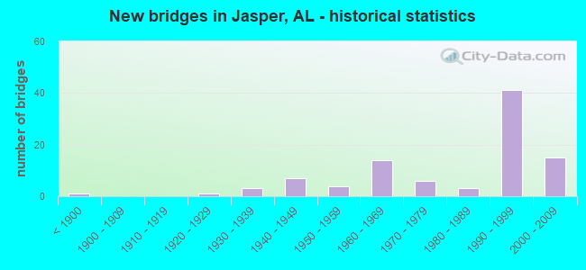
- New bridges - historical statistics
- 1Before 1900
- 11920-1929
- 31930-1939
- 71940-1949
- 41950-1959
- 141960-1969
- 61970-1979
- 31980-1989
- 411990-1999
- 152000-2009
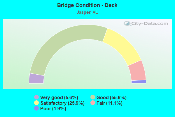
- Bridge Condition - Deck
- 5.6%Very good
- 55.6%Good
- 25.9%Satisfactory
- 11.1%Fair
- 1.9%Poor
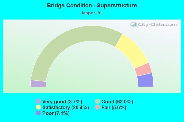
- Bridge Condition - Superstructure
- 3.7%Very good
- 63.0%Good
- 20.4%Satisfactory
- 5.6%Fair
- 7.4%Poor
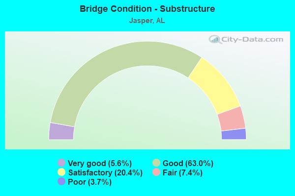
- Bridge Condition - Substructure
- 5.6%Very good
- 63.0%Good
- 20.4%Satisfactory
- 7.4%Fair
- 3.7%Poor
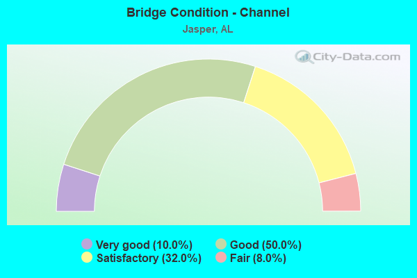
- Bridge Condition - Channel
- 10.0%Very good
- 50.0%Good
- 32.0%Satisfactory
- 8.0%Fair
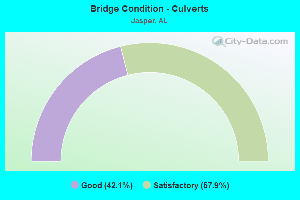
- Bridge Condition - Culverts
- 42.1%Good
- 57.9%Satisfactory
Find on map >> Show street view
Structure Number: 17037, Location: I-22 over AL-69 (Lat: 33.819397, Lng: -87.313181), Route carried "under" structure: State highway 69, Year Built: 1996, Structure Length: 0. m, Average Daily Traffic: 2,240 (year 2013), Truck Traffic: 12%, Features Intersected: AL-69, Facility Carried by Structure: I-22
Minimum Vertical Clearance: 5.79m (19.00ft), Kilometerpoint: 319.616, Lanes on structure: 2, Lanes under structure: 2, Material/Design: Prestressed concrete, Design/Construction: Stringer/Multi-beam, Length of Maximum Span: 33.5m (109.9ft)
Find on map >> Show street view
Structure Number: 17251, Location: AL-102 over I-22 (Lat: 33.863600, Lng: -87.413467), Route carried "under" structure: Interstate 22, Year Built: 2000, Structure Length: 0. m, Average Daily Traffic: 19,700 (year 2013), Truck Traffic: 24%, Features Intersected: I-22, Facility Carried by Structure: Future AL-102
Minimum Vertical Clearance: 5.55m (18.21ft), Kilometerpoint: 86.200, Lanes on structure: 2, Lanes under structure: 4, Material/Design: Prestressed concrete, Design/Construction: Stringer/Multi-beam, Length of Maximum Span: 35.1m (115.2ft)
Find on map >> Show street view
Structure Number: 17254, Location: 2.7 MI. W Jasper INT (Lat: 33.862553, Lng: -87.393494), Route carried "under" structure: Alternate County highway , Year Built: 2000, Structure Length: 0. m, Average Daily Traffic: 100 (year 2001), Features Intersected: Blackwell Rd, Facility Carried by Structure: I-22
Minimum Vertical Clearance: 23.64m (77.56ft), Kilometerpoint: 0.000, Lanes on structure: 3, Lanes under structure: 3, Material/Design: Prestressed concrete, Design/Construction: Stringer/Multi-beam, Length of Maximum Span: 32.0m (105.0ft)
Find on map >> Show street view
Structure Number: 17255, Location: 2.7 Miles W Jasper Int (Lat: 33.862258, Lng: -87.393536), Route carried "under" structure: Alternate County highway , Year Built: 2000, Structure Length: 0. m, Average Daily Traffic: 500 (year 2002), Features Intersected: Blackwell Rd, Facility Carried by Structure: I-22
Minimum Vertical Clearance: 23.64m (77.56ft), Kilometerpoint: 0.000, Lanes on structure: 3, Lanes under structure: 2, Material/Design: Prestressed concrete, Design/Construction: Stringer/Multi-beam, Length of Maximum Span: 32.0m (105.0ft)
Find on map >> Show street view
Structure Number: 18173, Location: West of Cordova (Lat: 33.789317, Lng: -87.221675), Route carried "under" structure: Interstate 22, Year Built: 2002, Structure Length: 0. m, Average Daily Traffic: 19,030 (year 2013), Truck Traffic: 22%, Features Intersected: I-22, Facility Carried by Structure: East Lake Rd
Minimum Vertical Clearance: 8.53m (27.99ft), Kilometerpoint: 107.021, Lanes on structure: 2, Lanes under structure: 2, Toll: Toll bridge, Material/Design: Prestressed concrete, Design/Construction: Stringer/Multi-beam, Length of Maximum Span: 36.6m (120.1ft)