Bridge Statistics for Jefferson City, Missouri (MO)
Condition, Traffic, Stress, Structural Evaluation, Project Costs
- National Bridge Inventory (NBI) Statistics
- 406Number of bridges
- 4,295ft / 1,309mTotal length
- $161,958,000Total costs
- 2,509,962Total average daily traffic
- 238,979Total average daily truck traffic
- National Bridge Inventory (NBI) Registered Bridges for Jefferson City
- No street view available for this location
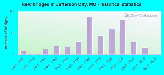
- New bridges - historical statistics
- 81900-1909
- 11910-1919
- 121920-1929
- 201930-1939
- 181940-1949
- 301950-1959
- 871960-1969
- 441970-1979
- 591980-1989
- 811990-1999
- 292000-2009
- 162010-2019
- 12020-2022
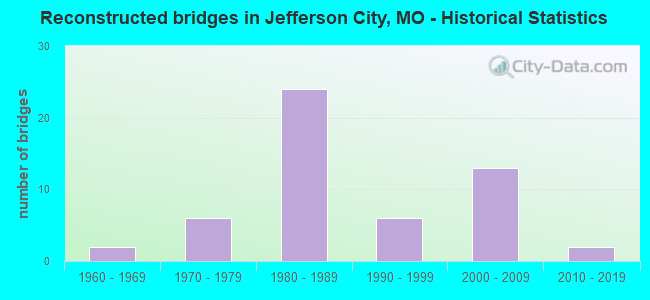
- Reconstructed bridges - Historical Statistics
- 21960-1969
- 61970-1979
- 241980-1989
- 61990-1999
- 132000-2009
- 22010-2019
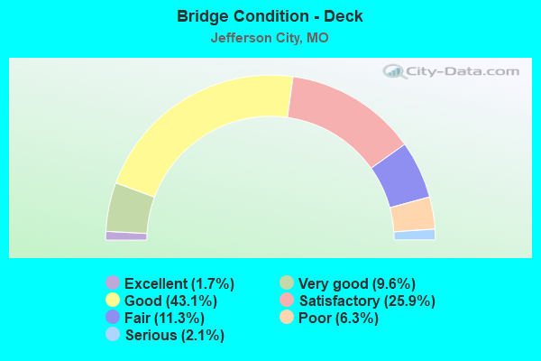
- Bridge Condition - Deck
- 1.7%Excellent
- 9.6%Very good
- 43.1%Good
- 25.9%Satisfactory
- 11.3%Fair
- 6.3%Poor
- 2.1%Serious
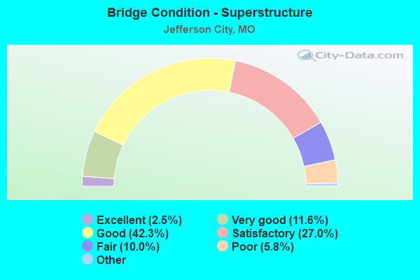
- Bridge Condition - Superstructure
- 2.5%Excellent
- 11.6%Very good
- 42.3%Good
- 27.0%Satisfactory
- 10.0%Fair
- 5.8%Poor
- 0.8%Serious
- 0.4%Critical
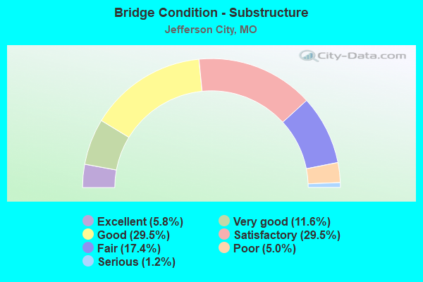
- Bridge Condition - Substructure
- 5.8%Excellent
- 11.6%Very good
- 29.5%Good
- 29.5%Satisfactory
- 17.4%Fair
- 5.0%Poor
- 1.2%Serious
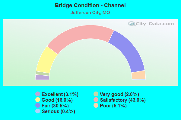
- Bridge Condition - Channel
- 3.1%Excellent
- 2.0%Very good
- 16.0%Good
- 43.0%Satisfactory
- 30.5%Fair
- 5.1%Poor
- 0.4%Serious
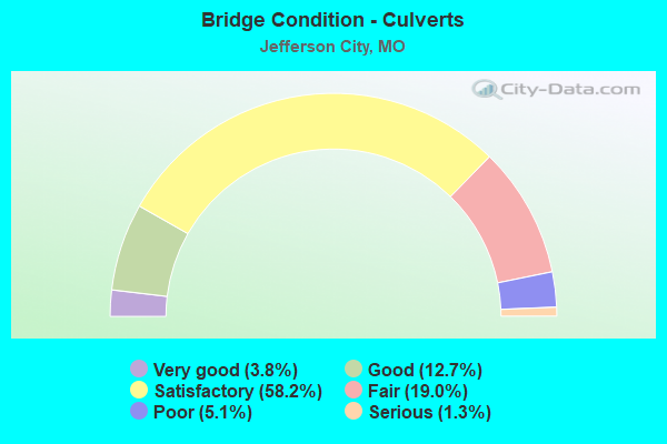
- Bridge Condition - Culverts
- 3.8%Very good
- 12.7%Good
- 58.2%Satisfactory
- 19.0%Fair
- 5.1%Poor
- 1.3%Serious
Find on map >> Show street view
Structure Number: 15768, Location: S 34 T 20 N R 12 E (Lat: 36.327883, Lng: -89.737278), Route carried "on" structure: County highway 99, Year Built: 1993, Status: Open, Structure Length: 0.98m (3.22ft), Average Daily Traffic: 100 (year 2021), Truck Traffic: 10%, Average Future Daily Traffic: 130 (year 2041), Features Intersected: DRAIN DTCH, Facility Carried by Structure: COUNTY RD 244
Minimum Vertical Clearance: 30+ m (98+ ft), Kilometerpoint: 1.127, Lanes on structure: 2, Owner: County Highway Agency, Approaching Roadway Width: 6.1m (20.0ft), Material/Design: Steel, Design/Construction: Culvert, Number Of Spans In Main Unit: 2, Length of Maximum Span: 4.3m (14.1ft)
Condition: Channel: Good, Culverts: Satisfactory, Operating Rating: 42.3 metric tons, Method Used To Determine Operating Rating: Allowable Stress (AS), Inventory Rating: 25.2 metric tons, Method Used To Determine Inventory Rating: Allowable Stress (AS), Structural Evaluation: Equal to present minimum criteria, Waterway Adequacy: Superior to present desirable criteria, Approach Roadway Alignment: Equal to present desirable criteria, Designated Inspection Frequency: Every 24 months, Inspection Date: November 2020
Find on map >> Show street view
Structure Number: 1577, Location: S 15 T 29 N R 30 W (Lat: 37.240056, Lng: -94.198347), Route carried "on" structure: State highway BB, Year Built: 1967, Year Reconstructed: 2005, Status: Open, Structure Length: 4.66m (15.29ft), Average Daily Traffic: 764 (year 2021), Truck Traffic: 15%, Average Future Daily Traffic: 1,146 (year 2041), Design Load: H 15, Features Intersected: DRY FK CR
Minimum Vertical Clearance: 30+ m (98+ ft), Kilometerpoint: 5.900, Lanes on structure: 2, Owner: State Highway Agency, Approaching Roadway Width: 6.1m (20.0ft), Skew: 1 degrees, Material/Design: Steel continuous, Design/Construction: Stringer/Multi-beam, Number Of Spans In Main Unit: 3, Length of Maximum Span: 18.3m (60.0ft), Curb-To-Curb Width: 8.3m (27.2ft), Out-to-Out Width: 8.8m (28.9ft)
Condition: Deck: Very good, Superstructure: Good, Substructure: Satisfactory, Channel: Fair, Operating Rating: 30.6 metric tons, Method Used To Determine Operating Rating: Load Factor (LF), Inventory Rating: 18.0 metric tons, Method Used To Determine Inventory Rating: Load Factor (LF), Structural Evaluation: Somewhat better than minimum adequacy, Deck Geometry: Somewhat better than minimum adequacy, Waterway Adequacy: Equal to present desirable criteria, Approach Roadway Alignment: Equal to present desirable criteria, Designated Inspection Frequency: Every 24 months, Inspection Date: July 2021, Deck Structure Type: Concrete Cast-file-Place, Wearing Surface/Protective System: Wearing Surface: Monolithic Concrete, Deck Protection: Epoxy Coated Reinforcing
Find on map >> Show street view
Structure Number: 15775, Location: S 17 T 52 N R 10 W (Lat: 39.282167, Lng: -92.051056), Route carried "on" structure: County highway 99, Year Built: 1978, Status: Open, Structure Length: 1.62m (5.31ft), Average Daily Traffic: 50 (year 2021), Truck Traffic: 10%, Average Future Daily Traffic: 63 (year 2041), Design Load: H 10, Features Intersected: YOUNGS CR, Facility Carried by Structure: COUNTY RD 248
Minimum Vertical Clearance: 30+ m (98+ ft), Kilometerpoint: 2.897, Lanes on structure: 2, Owner: County Highway Agency, Approaching Roadway Width: 5.8m (19.0ft), Material/Design: Steel, Design/Construction: Girder and Floorbeam System, Number Of Spans In Main Unit: 1, Length of Maximum Span: 15.2m (49.9ft), Curb-To-Curb Width: 6.1m (20.0ft), Out-to-Out Width: 6.2m (20.3ft)
Condition: Deck: Fair, Superstructure: Fair, Substructure: Satisfactory, Channel: Satisfactory, Operating Rating: 50.4 metric tons, Method Used To Determine Operating Rating: Allowable Stress (AS), Inventory Rating: 36.0 metric tons, Method Used To Determine Inventory Rating: Allowable Stress (AS), Structural Evaluation: Somewhat better than minimum adequacy, Deck Geometry: Somewhat better than minimum adequacy, Waterway Adequacy: Somewhat better than minimum adequacy, Approach Roadway Alignment: Equal to present desirable criteria, Designated Inspection Frequency: Every 24 months, Critical Feature Inspection Frequency: Every 24 months, Inspection Date: April 2021, Critical Feature Inspection Date: April 2021, Deck Structure Type: Concrete Cast-file-Place
Find on map >> Show street view
Structure Number: 15776, Location: S 33 T 57 N R 33 W (Lat: 39.703903, Lng: -94.606272), Route carried "on" structure: County highway 99, Year Built: 2000, Status: Open, Structure Length: 2.80m (9.19ft), Average Daily Traffic: 20 (year 2021), Truck Traffic: 10%, Average Future Daily Traffic: 23 (year 2041), Design Load: HS 20, Features Intersected: MALDEN CR, Facility Carried by Structure: SE KERNS RD
Minimum Vertical Clearance: 30+ m (98+ ft), Kilometerpoint: 2.897, Lanes on structure: 2, Owner: County Highway Agency, Approaching Roadway Width: 8.5m (27.9ft), Material/Design: Steel, Design/Construction: Stringer/Multi-beam, Number Of Spans In Main Unit: 1, Length of Maximum Span: 27.4m (89.9ft), Curb-To-Curb Width: 7.9m (25.9ft), Out-to-Out Width: 8.1m (26.6ft)
Condition: Deck: Satisfactory, Superstructure: Very good, Substructure: Very good, Channel: Satisfactory, Operating Rating: 78.3 metric tons, Method Used To Determine Operating Rating: Load Factor (LF), Inventory Rating: 46.8 metric tons, Method Used To Determine Inventory Rating: Load Factor (LF), Structural Evaluation: Equal to present desirable criteria, Deck Geometry: Equal to present minimum criteria, Waterway Adequacy: Superior to present desirable criteria, Approach Roadway Alignment: Equal to present desirable criteria, Designated Inspection Frequency: Every 24 months, Inspection Date: Febuary 2021, Deck Structure Type: Concrete Cast-file-Place, Wearing Surface/Protective System: Wearing Surface: Monolithic Concrete
Find on map >> Show street view
Structure Number: 1579, Location: S 24 T 49 N R 3 W (Lat: 38.992153, Lng: -91.192117), Route carried "on" structure: State highway A, Year Built: 1967, Status: Open, Structure Length: 1.40m (4.59ft), Average Daily Traffic: 1,621 (year 2021), Truck Traffic: 12%, Average Future Daily Traffic: 3,242 (year 2041), Design Load: H 15, Features Intersected: BATY BR
Minimum Vertical Clearance: 30+ m (98+ ft), Kilometerpoint: 5.922, Lanes on structure: 2, Owner: State Highway Agency, Approaching Roadway Width: 7.3m (24.0ft), Material/Design: Concrete continuous, Design/Construction: Culvert, Number Of Spans In Main Unit: 3, Length of Maximum Span: 4.3m (14.1ft), Curb-To-Curb Width: 9.8m (32.2ft), Out-to-Out Width: 10.4m (34.1ft)
Condition: Channel: Fair, Culverts: Satisfactory, Operating Rating: 72.0 metric tons, Method Used To Determine Operating Rating: Load Factor (LF), Inventory Rating: 43.2 metric tons, Method Used To Determine Inventory Rating: Load Factor (LF), Structural Evaluation: Equal to present minimum criteria, Deck Geometry: Somewhat better than minimum adequacy, Waterway Adequacy: Equal to present desirable criteria, Approach Roadway Alignment: Equal to present desirable criteria, Designated Inspection Frequency: Every 24 months, Inspection Date: November 2020
Find on map >> Show street view
Structure Number: 1582, Location: S 4 T 40 N R 2 W (Lat: 38.232953, Lng: -91.148658), Route carried "on" structure: ServiceState highway 44, Year Built: 1972, Status: Open, Structure Length: 1.34m (4.40ft), Average Daily Traffic: 3,050 (year 2021), Truck Traffic: 10%, Average Future Daily Traffic: 5,795 (year 2041), Design Load: H 15, Features Intersected: WINSEL CR
Minimum Vertical Clearance: 30+ m (98+ ft), Kilometerpoint: 21.953, Lanes on structure: 2, Owner: State Highway Agency, Approaching Roadway Width: 8.5m (27.9ft), Skew: 3 degrees, Material/Design: Concrete continuous, Design/Construction: Culvert, Number Of Spans In Main Unit: 3, Length of Maximum Span: 3.7m (12.1ft), Curb-To-Curb Width: 10.1m (33.1ft), Out-to-Out Width: 10.7m (35.1ft)
Condition: Channel: Fair, Culverts: Fair, Operating Rating: 69.3 metric tons, Method Used To Determine Operating Rating: Load Factor (LF), Inventory Rating: 41.4 metric tons, Method Used To Determine Inventory Rating: Load Factor (LF), Structural Evaluation: Somewhat better than minimum adequacy, Deck Geometry: Meets minimum limits, Waterway Adequacy: Equal to present desirable criteria, Approach Roadway Alignment: Equal to present desirable criteria, Designated Inspection Frequency: Every 24 months, Inspection Date: December 2021
Find on map >> Show street view
Structure Number: 15823, Location: S 2 T 54 N R 27 W (Lat: 39.519444, Lng: -93.889547), Route carried "on" structure: County highway 101, Year Built: 1940, Year Reconstructed: 1986, Status: Closed, Structure Length: 1.71m (5.61ft), Average Daily Traffic: 25 (year 2021), Truck Traffic: 10%, Average Future Daily Traffic: 34 (year 2041), Features Intersected: SOUTH MUD CR, Facility Carried by Structure: MARY LOIS RD
Minimum Vertical Clearance: 30+ m (98+ ft), Kilometerpoint: 0.644, Lanes on structure: 1, Owner: County Highway Agency, Approaching Roadway Width: 5.5m (18.0ft), Material/Design: Steel, Design/Construction: Stringer/Multi-beam, Number Of Spans In Main Unit: 3, Length of Maximum Span: 5.5m (18.0ft), Curb-To-Curb Width: 4.9m (16.1ft), Out-to-Out Width: 4.9m (16.1ft)
Condition: Deck: Good, Superstructure: Good, Substructure: Poor, Channel: Poor, Deck Geometry: High priority of corrective action, Waterway Adequacy: Better than present minimum criteria, Approach Roadway Alignment: Equal to present minimum criteria, Bridge Posting: Required (Relationship of Operating Rating to Maximum Legal Load: > 39.9% below), Length Of Structure Improvement: 0.24m (0.79ft), Designated Inspection Frequency: Every 24 months, Inspection Date: May 2017, Bridge Improvement Cost: $175,000, Roadway Improvement Cost: $18,000, Total Project Cost: $263,000 ( Estimate for 2022), Deck Structure Type: Wood or Timber, Wearing Surface/Protective System: Wearing Surface: Wood or Timber
Find on map >> Show street view
Structure Number: 15854, Location: S 25 T 49 N R 16 W (Lat: 39.019989, Lng: -92.666247), Route carried "on" structure: County highway 102, Year Built: 1968, Year Reconstructed: 2008, Status: Open, Structure Length: 1.22m (4.00ft), Average Daily Traffic: 50 (year 2020), Truck Traffic: 10%, Average Future Daily Traffic: 55 (year 2040), Features Intersected: SALT CR, Facility Carried by Structure: COUNTY RD 467
Minimum Vertical Clearance: 30+ m (98+ ft), Kilometerpoint: 0.161, Lanes on structure: 2, Owner: County Highway Agency, Approaching Roadway Width: 5.5m (18.0ft), Material/Design: Steel, Design/Construction: Stringer/Multi-beam, Number Of Spans In Main Unit: 1, Length of Maximum Span: 11.5m (37.7ft), Curb-To-Curb Width: 5.7m (18.7ft), Out-to-Out Width: 5.9m (19.4ft)
Condition: Deck: Good, Superstructure: Good, Substructure: Fair, Channel: Fair, Operating Rating: 54.0 metric tons, Method Used To Determine Operating Rating: Load Factor (LF), Inventory Rating: 32.4 metric tons, Method Used To Determine Inventory Rating: Load Factor (LF), Structural Evaluation: Somewhat better than minimum adequacy, Deck Geometry: Meets minimum limits, Waterway Adequacy: Better than present minimum criteria, Approach Roadway Alignment: Equal to present minimum criteria, Designated Inspection Frequency: Every 24 months, Inspection Date: Febuary 2020, Deck Structure Type: Concrete Cast-file-Place
Find on map >> Show street view
Structure Number: 15856, Location: S 19 T 50 N R 29 W (Lat: 39.122425, Lng: -94.156228), Route carried "on" structure: County highway 102, Year Built: 1965, Status: Open, Structure Length: 0.82m (2.69ft), Average Daily Traffic: 45 (year 2021), Truck Traffic: 5%, Average Future Daily Traffic: 68 (year 2041), Features Intersected: BR OF FIRE PRAIRIE, Facility Carried by Structure: STOENNER RD
Minimum Vertical Clearance: 30+ m (98+ ft), Kilometerpoint: 0.322, Lanes on structure: 2, Owner: County Highway Agency, Approaching Roadway Width: 7.9m (25.9ft), Material/Design: Concrete, Design/Construction: Culvert, Number Of Spans In Main Unit: 2, Length of Maximum Span: 4.0m (13.1ft)
Condition: Channel: Fair, Culverts: Poor, Operating Rating: 49.5 metric tons, Method Used To Determine Operating Rating: Allowable Stress (AS), Inventory Rating: 16.2 metric tons, Method Used To Determine Inventory Rating: Allowable Stress (AS), Structural Evaluation: Meets minimum limits, Waterway Adequacy: Equal to present desirable criteria, Approach Roadway Alignment: Equal to present desirable criteria, Length Of Structure Improvement: 0.15m (0.49ft), Designated Inspection Frequency: Every 24 months, Inspection Date: Febuary 2021, Bridge Improvement Cost: $85,000, Roadway Improvement Cost: $9,000, Total Project Cost: $128,000 ( Estimate for 2022)
Find on map >> Show street view
Structure Number: 15932, Location: S 2969 T 36 N R 5 E (Lat: 37.786978, Lng: -90.436061), Route carried "on" structure: County highway 104, Year Built: 1992, Status: Open, Structure Length: 1.04m (3.41ft), Average Daily Traffic: 600 (year 2021), Truck Traffic: 10%, Average Future Daily Traffic: 900 (year 2041), Design Load: HS 20, Features Intersected: CREEK, Facility Carried by Structure: MAPLE ST
Minimum Vertical Clearance: 30+ m (98+ ft), Kilometerpoint: 0.805, Lanes on structure: 2, Owner: City or Municipal Highway Agency, Approaching Roadway Width: 10.1m (33.1ft), Skew: 2 degrees, Material/Design: Concrete, Design/Construction: Slab, Number Of Spans In Main Unit: 2, Length of Maximum Span: 4.3m (14.1ft), Curb-To-Curb Width: 11.6m (38.1ft), Out-to-Out Width: 12.2m (40.0ft)
Condition: Deck: Good, Superstructure: Good, Substructure: Good, Channel: Satisfactory, Operating Rating: 31.5 metric tons, Method Used To Determine Operating Rating: Allowable Stress (AS), Inventory Rating: 25.2 metric tons, Method Used To Determine Inventory Rating: Allowable Stress (AS), Structural Evaluation: Equal to present minimum criteria, Deck Geometry: Better than present minimum criteria, Waterway Adequacy: Equal to present minimum criteria, Approach Roadway Alignment: Equal to present desirable criteria, Designated Inspection Frequency: Every 24 months, Inspection Date: December 2020, Deck Structure Type: Concrete Cast-file-Place, Wearing Surface/Protective System: Wearing Surface: Bituminous
Find on map >> Show street view
Structure Number: 15937, Location: S 1 T 60 N R 14 W (Lat: 40.037044, Lng: -92.404086), Route carried "on" structure: County highway 104, Year Built: 1992, Status: Open, Structure Length: 3.66m (12.01ft), Average Daily Traffic: 20 (year 2019), Truck Traffic: 10%, Average Future Daily Traffic: 22 (year 2039), Design Load: HS 20, Features Intersected: BEAR CR, Facility Carried by Structure: LANTERN ST
Minimum Vertical Clearance: 30+ m (98+ ft), Kilometerpoint: 1.287, Lanes on structure: 2, Owner: County Highway Agency, Approaching Roadway Width: 4.9m (16.1ft), Material/Design: Prestressed concrete continuous, Design/Construction: Tee Beam, Number Of Spans In Main Unit: 3, Length of Maximum Span: 12.2m (40.0ft), Curb-To-Curb Width: 7.3m (24.0ft), Out-to-Out Width: 8.2m (26.9ft)
Condition: Deck: Good, Superstructure: Good, Substructure: Fair, Channel: Fair, Operating Rating: 54.0 metric tons, Method Used To Determine Operating Rating: Allowable Stress (AS), Inventory Rating: 32.4 metric tons, Method Used To Determine Inventory Rating: Allowable Stress (AS), Structural Evaluation: Somewhat better than minimum adequacy, Deck Geometry: Equal to present minimum criteria, Waterway Adequacy: Equal to present desirable criteria, Approach Roadway Alignment: Equal to present desirable criteria, Designated Inspection Frequency: Every 24 months, Inspection Date: December 2021, Deck Structure Type: Concrete Cast-file-Place, Wearing Surface/Protective System: Wearing Surface: Monolithic Concrete
Find on map >> Show street view
Structure Number: 15938, Location: S 1 T 19 N R 11 E (Lat: 36.321047, Lng: -89.812192), Route carried "on" structure: County highway 104, Year Built: 1991, Status: Posted for load, Structure Length: 0.64m (2.10ft), Average Daily Traffic: 60 (year 2021), Truck Traffic: 10%, Average Future Daily Traffic: 78 (year 2041), Features Intersected: DRAIN DTCH, Facility Carried by Structure: COUNTY RD 244
Minimum Vertical Clearance: 30+ m (98+ ft), Kilometerpoint: 1.287, Lanes on structure: 2, Owner: County Highway Agency, Approaching Roadway Width: 7.9m (25.9ft), Material/Design: Steel, Design/Construction: Culvert, Number Of Spans In Main Unit: 2, Length of Maximum Span: 2.7m (8.9ft)
Condition: Channel: Good, Culverts: Serious, Operating Rating: 20.7 metric tons, Method Used To Determine Operating Rating: Field evaluation and documented engineering judgment, Inventory Rating: 12.6 metric tons, Method Used To Determine Inventory Rating: Field evaluation and documented engineering judgment, Structural Evaluation: High priority of corrective action, Waterway Adequacy: Equal to present desirable criteria, Approach Roadway Alignment: Equal to present desirable criteria, Bridge Posting: Required (Relationship of Operating Rating to Maximum Legal Load: 10.0 - 19.9% below), Length Of Structure Improvement: 0.13m (0.43ft), Designated Inspection Frequency: Every 24 months, Inspection Date: November 2020, Bridge Improvement Cost: $125,000, Roadway Improvement Cost: $13,000, Total Project Cost: $188,000 ( Estimate for 2022)
Find on map >> Show street view
Structure Number: 15939, Location: S 15 T 33 N R 33 W (Lat: 37.608739, Lng: -94.532186), Route carried "on" structure: County highway 104, Year Built: 1900, Status: Closed, Structure Length: 2.29m (7.51ft), Average Daily Traffic: 5 (year 2021), Truck Traffic: 10%, Average Future Daily Traffic: 7 (year 2041), Features Intersected: DRYWOOD CR, Facility Carried by Structure: NW 70TH RD
Minimum Vertical Clearance: 30+ m (98+ ft), Kilometerpoint: 1.448, Lanes on structure: 1, Owner: County Highway Agency, Approaching Roadway Width: 3.7m (12.1ft), Material/Design: Steel, Design/Construction: Truss - Thru, Number Of Spans In Main Unit: 2, Length of Maximum Span: 11.3m (37.1ft), Curb-To-Curb Width: 3.5m (11.5ft), Out-to-Out Width: 3.5m (11.5ft)
Condition: Deck: Fair, Superstructure: Critical, Substructure: Poor, Channel: Poor, Deck Geometry: High priority of corrective action, Waterway Adequacy: Somewhat better than minimum adequacy, Approach Roadway Alignment: High priority of corrective action, Bridge Posting: Required (Relationship of Operating Rating to Maximum Legal Load: > 39.9% below), Length Of Structure Improvement: 0.31m (1.02ft), Designated Inspection Frequency: Every 24 months, Critical Feature Inspection Frequency: Every 24 months, Inspection Date: January 2016, Critical Feature Inspection Date: July 2015, Bridge Improvement Cost: $226,000, Roadway Improvement Cost: $23,000, Total Project Cost: $340,000 ( Estimate for 2022), Deck Structure Type: Concrete Cast-file-Place, Wearing Surface/Protective System: Wearing Surface: Monolithic Concrete
Find on map >> Show street view
Structure Number: 1594, Location: S 22 T 43 N R 22 W (Lat: 38.488778, Lng: -93.338667), Route carried "on" structure: State highway P, Year Built: 1966, Status: Open, Structure Length: 0.64m (2.10ft), Average Daily Traffic: 224 (year 2021), Truck Traffic: 9%, Average Future Daily Traffic: 358 (year 2041), Design Load: H 15, Features Intersected: FLAT CR
Minimum Vertical Clearance: 30+ m (98+ ft), Kilometerpoint: 13.131, Lanes on structure: 2, Owner: State Highway Agency, Approaching Roadway Width: 7.3m (24.0ft), Material/Design: Concrete continuous, Design/Construction: Culvert, Number Of Spans In Main Unit: 2, Length of Maximum Span: 3.4m (11.2ft), Curb-To-Curb Width: 9.6m (31.5ft), Out-to-Out Width: 10.2m (33.5ft)
Condition: Channel: Satisfactory, Culverts: Satisfactory, Operating Rating: 66.6 metric tons, Method Used To Determine Operating Rating: Load Factor (LF), Inventory Rating: 39.6 metric tons, Method Used To Determine Inventory Rating: Load Factor (LF), Structural Evaluation: Equal to present minimum criteria, Deck Geometry: Equal to present minimum criteria, Waterway Adequacy: Equal to present minimum criteria, Approach Roadway Alignment: Equal to present desirable criteria, Designated Inspection Frequency: Every 24 months, Inspection Date: March 2021
Find on map >> Show street view
Structure Number: 15948, Location: S 26 T 38 N R 33 W (Lat: 38.043667, Lng: -94.522631), Route carried "on" structure: County highway 104, Year Built: 1950, Status: Posted for load, Structure Length: 1.92m (6.30ft), Average Daily Traffic: 30 (year 2021), Truck Traffic: 10%, Average Future Daily Traffic: 39 (year 2041), Features Intersected: TRIB OF W FK CR, Facility Carried by Structure: COUNTY RD ARNOLD
Minimum Vertical Clearance: 30+ m (98+ ft), Kilometerpoint: 4.506, Lanes on structure: 1, Owner: County Highway Agency, Approaching Roadway Width: 5.5m (18.0ft), Material/Design: Steel, Design/Construction: Stringer/Multi-beam, Number Of Spans In Main Unit: 2, Length of Maximum Span: 9.4m (30.8ft), Curb-To-Curb Width: 4.3m (14.1ft), Out-to-Out Width: 4.3m (14.1ft)
Condition: Deck: Fair, Superstructure: Satisfactory, Substructure: Fair, Channel: Poor, Operating Rating: 21.6 metric tons, Method Used To Determine Operating Rating: Allowable Stress (AS), Inventory Rating: 12.6 metric tons, Method Used To Determine Inventory Rating: Allowable Stress (AS), Structural Evaluation: Meets minimum limits, Deck Geometry: Equal to present minimum criteria, Waterway Adequacy: Meets minimum limits, Approach Roadway Alignment: Equal to present minimum criteria, Bridge Posting: Required (Relationship of Operating Rating to Maximum Legal Load: 10.0 - 19.9% below), Designated Inspection Frequency: Every 24 months, Inspection Date: December 2021, Deck Structure Type: Concrete Cast-file-Place, Wearing Surface/Protective System: Wearing Surface: Monolithic Concrete
Find on map >> Show street view
Structure Number: 15949, Location: S 7 T 43 N R 1 E (Lat: 38.491864, Lng: -90.942811), Route carried "on" structure: County highway 104, Year Built: 2000, Status: Open, Structure Length: 1.04m (3.41ft), Average Daily Traffic: 450 (year 2021), Truck Traffic: 5%, Average Future Daily Traffic: 810 (year 2041), Design Load: HS 20, Features Intersected: BROWNS BR OF DUBOI, Facility Carried by Structure: ST JOHN'S RD
Minimum Vertical Clearance: 30+ m (98+ ft), Kilometerpoint: 4.506, Lanes on structure: 2, Owner: County Highway Agency, Approaching Roadway Width: 7.3m (24.0ft), Material/Design: Concrete, Design/Construction: Culvert, Number Of Spans In Main Unit: 1, Length of Maximum Span: 9.8m (32.2ft), Curb-To-Curb Width: 8.1m (26.6ft), Out-to-Out Width: 10.4m (34.1ft)
Condition: Channel: Satisfactory, Culverts: Fair, Operating Rating: 54.0 metric tons, Method Used To Determine Operating Rating: Load Factor (LF), Inventory Rating: 32.4 metric tons, Method Used To Determine Inventory Rating: Load Factor (LF), Structural Evaluation: Somewhat better than minimum adequacy, Deck Geometry: Somewhat better than minimum adequacy, Waterway Adequacy: Equal to present desirable criteria, Approach Roadway Alignment: Equal to present desirable criteria, Designated Inspection Frequency: Every 24 months, Inspection Date: March 2021, Wearing Surface/Protective System: Wearing Surface: Bituminous
Find on map >> Show street view
Structure Number: 15951, Location: S 25 T 38 N R 33 W (Lat: 38.043450, Lng: -94.512339), Route carried "on" structure: County highway 104, Year Built: 1970, Year Reconstructed: 2013, Status: Open, Structure Length: 3.11m (10.20ft), Average Daily Traffic: 30 (year 2021), Truck Traffic: 10%, Average Future Daily Traffic: 39 (year 2041), Design Load: HS 20, Features Intersected: W FORK CR, Facility Carried by Structure: ARNOLD RD
Minimum Vertical Clearance: 30+ m (98+ ft), Kilometerpoint: 6.920, Lanes on structure: 1, Owner: County Highway Agency, Approaching Roadway Width: 4.9m (16.1ft), Material/Design: Steel, Design/Construction: Stringer/Multi-beam, Number Of Spans In Main Unit: 5, Length of Maximum Span: 12.2m (40.0ft), Curb-To-Curb Width: 4.8m (15.7ft), Out-to-Out Width: 4.9m (16.1ft)
Condition: Deck: Very good, Superstructure: Satisfactory, Substructure: Satisfactory, Channel: Satisfactory, Operating Rating: 36.9 metric tons, Method Used To Determine Operating Rating: Load Factor (LF), Inventory Rating: 21.6 metric tons, Method Used To Determine Inventory Rating: Load Factor (LF), Structural Evaluation: Equal to present minimum criteria, Deck Geometry: Equal to present desirable criteria, Waterway Adequacy: Somewhat better than minimum adequacy, Approach Roadway Alignment: Somewhat better than minimum adequacy, Designated Inspection Frequency: Every 24 months, Inspection Date: December 2021, Deck Structure Type: Concrete Cast-file-Place, Wearing Surface/Protective System: Wearing Surface: Monolithic Concrete
Find on map >> Show street view
Structure Number: 16176, Location: S 30 T 31 N R 8 E (Lat: 37.331439, Lng: -90.213392), Route carried "on" structure: County highway 113, Year Built: 1935, Status: Open, Structure Length: 2.65m (8.69ft), Average Daily Traffic: 25 (year 2019), Truck Traffic: 10%, Average Future Daily Traffic: 33 (year 2039), Features Intersected: CASTOR RVR, Facility Carried by Structure: COUNTY RD #313
Minimum Vertical Clearance: 30+ m (98+ ft), Kilometerpoint: 0.483, Lanes on structure: 1, Owner: County Highway Agency, Approaching Roadway Width: 3.7m (12.1ft), Material/Design: Steel, Design/Construction: Culvert, Number Of Spans In Main Unit: 30, Length of Maximum Span: 0.9m (3.0ft), Curb-To-Curb Width: 3.5m (11.5ft), Out-to-Out Width: 3.5m (11.5ft)
Condition: Channel: Poor, Culverts: Fair, Operating Rating: 49.5 metric tons, Method Used To Determine Operating Rating: Allowable Stress (AS), Inventory Rating: 16.2 metric tons, Method Used To Determine Inventory Rating: Allowable Stress (AS), Structural Evaluation: Somewhat better than minimum adequacy, Deck Geometry: High priority of corrective action, Waterway Adequacy: Meets minimum limits, Approach Roadway Alignment: Meets minimum limits, Length Of Structure Improvement: 0.36m (1.18ft), Designated Inspection Frequency: Every 24 months, Inspection Date: December 2021, Bridge Improvement Cost: $125,000, Roadway Improvement Cost: $13,000, Total Project Cost: $188,000 ( Estimate for 2022), Deck Structure Type: Concrete Cast-file-Place, Wearing Surface/Protective System: Wearing Surface: Monolithic Concrete
Find on map >> Show street view
Structure Number: 16177, Location: S 11 T 60 N R 31 W (Lat: 40.024197, Lng: -94.340547), Route carried "on" structure: County highway 113, Year Built: 1990, Status: Open, Structure Length: 1.07m (3.51ft), Average Daily Traffic: 20 (year 2021), Truck Traffic: 10%, Average Future Daily Traffic: 23 (year 2041), Features Intersected: E FK LOST CR, Facility Carried by Structure: NE KING RD
Minimum Vertical Clearance: 30+ m (98+ ft), Kilometerpoint: 0.483, Lanes on structure: 2, Owner: County Highway Agency, Approaching Roadway Width: 5.5m (18.0ft), Skew: 4 degrees, Material/Design: Steel, Design/Construction: Stringer/Multi-beam, Number Of Spans In Main Unit: 1, Length of Maximum Span: 10.1m (33.1ft), Curb-To-Curb Width: 5.5m (18.0ft), Out-to-Out Width: 5.5m (18.0ft)
Condition: Deck: Good, Superstructure: Good, Substructure: Satisfactory, Channel: Satisfactory, Operating Rating: 33.3 metric tons, Method Used To Determine Operating Rating: Allowable Stress (AS), Inventory Rating: 20.7 metric tons, Method Used To Determine Inventory Rating: Allowable Stress (AS), Structural Evaluation: Equal to present minimum criteria, Deck Geometry: Meets minimum limits, Waterway Adequacy: Better than present minimum criteria, Approach Roadway Alignment: Equal to present minimum criteria, Designated Inspection Frequency: Every 24 months, Inspection Date: December 2020, Deck Structure Type: Concrete Cast-file-Place, Wearing Surface/Protective System: Wearing Surface: Monolithic Concrete
Find on map >> Show street view
Structure Number: 16518, Location: S 18 T 58 N R 24 W (Lat: 39.840847, Lng: -93.648211), Route carried "on" structure: County highway 123, Year Built: 1920, Status: Posted for load, Structure Length: 1.22m (4.00ft), Average Daily Traffic: 5 (year 2021), Truck Traffic: 10%, Average Future Daily Traffic: 6 (year 2041), Features Intersected: POLECAT CREEK, Facility Carried by Structure: COUNTY RD 525
Minimum Vertical Clearance: 30+ m (98+ ft), Kilometerpoint: 1.609, Lanes on structure: 1, Owner: County Highway Agency, Approaching Roadway Width: 4.6m (15.1ft), Material/Design: Steel, Design/Construction: Girder and Floorbeam System, Number Of Spans In Main Unit: 1, Length of Maximum Span: 11.9m (39.0ft), Curb-To-Curb Width: 4.6m (15.1ft), Out-to-Out Width: 4.6m (15.1ft)
Condition: Deck: Satisfactory, Superstructure: Satisfactory, Substructure: Good, Channel: Fair, Operating Rating: 16.2 metric tons, Method Used To Determine Operating Rating: Allowable Stress (AS), Inventory Rating: 8.1 metric tons, Method Used To Determine Inventory Rating: Allowable Stress (AS), Structural Evaluation: High priority of replacement, Deck Geometry: Better than present minimum criteria, Waterway Adequacy: Equal to present desirable criteria, Approach Roadway Alignment: Equal to present desirable criteria, Bridge Posting: Required (Relationship of Operating Rating to Maximum Legal Load: 30.0 - 39.9% below), Length Of Structure Improvement: 0.19m (0.62ft), Designated Inspection Frequency: Every 24 months, Critical Feature Inspection Frequency: Every 24 months, Inspection Date: January 2021, Critical Feature Inspection Date: January 2021, Bridge Improvement Cost: $138,000, Roadway Improvement Cost: $14,000, Total Project Cost: $206,000 ( Estimate for 2022), Deck Structure Type: Concrete Cast-file-Place
Find on map >> Show street view
Structure Number: 1652, Location: S 32 T 22 N R 1 E (Lat: 36.512475, Lng: -90.993228), Route carried "on" structure: State highway DD, Year Built: 1966, Year Reconstructed: 2002, Status: Open, Structure Length: 3.54m (11.61ft), Average Daily Traffic: 126 (year 2021), Truck Traffic: 32%, Average Future Daily Traffic: 176 (year 2041), Design Load: H 15, Features Intersected: DRY CR
Minimum Vertical Clearance: 30+ m (98+ ft), Kilometerpoint: 3.104, Lanes on structure: 2, Owner: State Highway Agency, Approaching Roadway Width: 6.1m (20.0ft), Material/Design: Steel continuous, Design/Construction: Stringer/Multi-beam, Number Of Spans In Main Unit: 3, Length of Maximum Span: 13.1m (43.0ft), Curb-To-Curb Width: 7.9m (25.9ft), Out-to-Out Width: 8.7m (28.5ft)
Condition: Deck: Good, Superstructure: Very good, Substructure: Satisfactory, Channel: Satisfactory, Operating Rating: 34.2 metric tons, Method Used To Determine Operating Rating: Allowable Stress (AS), Inventory Rating: 18.0 metric tons, Method Used To Determine Inventory Rating: Allowable Stress (AS), Structural Evaluation: Somewhat better than minimum adequacy, Deck Geometry: Somewhat better than minimum adequacy, Waterway Adequacy: Equal to present minimum criteria, Approach Roadway Alignment: Equal to present desirable criteria, Designated Inspection Frequency: Every 24 months, Inspection Date: January 2022, Deck Structure Type: Concrete Cast-file-Place, Wearing Surface/Protective System: Wearing Surface: Epoxy Overlay
Find on map >> Show street view
Structure Number: 16522, Location: S 31 T 62 N R 38 W (Lat: 40.133403, Lng: -95.223258), Route carried "on" structure: County highway 123, Year Built: 1920, Status: Posted for load, Structure Length: 1.55m (5.09ft), Average Daily Traffic: 30 (year 2021), Truck Traffic: 10%, Average Future Daily Traffic: 35 (year 2041), Features Intersected: BR OF DAVIS CR, Facility Carried by Structure: LINCOLN RD
Minimum Vertical Clearance: 30+ m (98+ ft), Kilometerpoint: 1.770, Lanes on structure: 1, Owner: County Highway Agency, Approaching Roadway Width: 3.7m (12.1ft), Material/Design: Steel, Design/Construction: Truss - Thru, Number Of Spans In Main Unit: 1, Length of Maximum Span: 15.5m (50.9ft), Curb-To-Curb Width: 4.8m (15.7ft), Out-to-Out Width: 4.8m (15.7ft)
Condition: Deck: Fair, Superstructure: Poor, Substructure: Fair, Channel: Fair, Operating Rating: 6.3 metric tons, Method Used To Determine Operating Rating: Allowable Stress (AS), Inventory Rating: 3.6 metric tons, Method Used To Determine Inventory Rating: Allowable Stress (AS), Structural Evaluation: High priority of replacement, Deck Geometry: Equal to present desirable criteria, Waterway Adequacy: Equal to present desirable criteria, Approach Roadway Alignment: Equal to present desirable criteria, Bridge Posting: Required (Relationship of Operating Rating to Maximum Legal Load: > 39.9% below), Length Of Structure Improvement: 0.22m (0.72ft), Designated Inspection Frequency: Every 24 months, Critical Feature Inspection Frequency: Every 24 months, Inspection Date: November 2021, Critical Feature Inspection Date: January 2022, Bridge Improvement Cost: $160,000, Roadway Improvement Cost: $16,000, Total Project Cost: $240,000 ( Estimate for 2022), Deck Structure Type: Wood or Timber
Find on map >> Show street view
Structure Number: 16524, Location: S 5 T 55 N R 30 W (Lat: 39.607719, Lng: -94.291875), Route carried "on" structure: County highway 123, Year Built: 1997, Status: Open, Structure Length: 2.16m (7.09ft), Average Daily Traffic: 30 (year 2021), Truck Traffic: 10%, Average Future Daily Traffic: 35 (year 2041), Features Intersected: SHOAL CR, Facility Carried by Structure: NE 284TH ST
Minimum Vertical Clearance: 30+ m (98+ ft), Kilometerpoint: 2.092, Lanes on structure: 2, Owner: County Highway Agency, Approaching Roadway Width: 8.5m (27.9ft), Material/Design: Steel, Design/Construction: Stringer/Multi-beam, Number Of Spans In Main Unit: 1, Length of Maximum Span: 21.3m (69.9ft), Curb-To-Curb Width: 7.3m (24.0ft), Out-to-Out Width: 7.5m (24.6ft)
Condition: Deck: Good, Superstructure: Good, Substructure: Satisfactory, Channel: Fair, Operating Rating: 36.0 metric tons, Method Used To Determine Operating Rating: Load Factor (LF), Inventory Rating: 21.6 metric tons, Method Used To Determine Inventory Rating: Load Factor (LF), Structural Evaluation: Equal to present minimum criteria, Deck Geometry: Equal to present minimum criteria, Waterway Adequacy: Equal to present desirable criteria, Approach Roadway Alignment: Equal to present desirable criteria, Designated Inspection Frequency: Every 24 months, Inspection Date: December 2020, Deck Structure Type: Concrete Cast-file-Place
Find on map >> Show street view
Structure Number: 16528, Location: S 20 T 60 N R 18 W (Lat: 40.006300, Lng: -92.941397), Route carried "on" structure: County highway 123, Year Built: 1993, Status: Open, Structure Length: 1.83m (6.00ft), Average Daily Traffic: 15 (year 2021), Truck Traffic: 10%, Average Future Daily Traffic: 17 (year 2041), Features Intersected: E YELLOW CR, Facility Carried by Structure: LADUE RD
Minimum Vertical Clearance: 30+ m (98+ ft), Kilometerpoint: 2.414, Lanes on structure: 1, Owner: County Highway Agency, Approaching Roadway Width: 4.9m (16.1ft), Material/Design: Steel, Design/Construction: Stringer/Multi-beam, Number Of Spans In Main Unit: 2, Length of Maximum Span: 13.7m (44.9ft), Curb-To-Curb Width: 4.9m (16.1ft), Out-to-Out Width: 5.2m (17.1ft)
Condition: Deck: Good, Superstructure: Satisfactory, Substructure: Serious, Channel: Serious, Operating Rating: 65.7 metric tons, Method Used To Determine Operating Rating: Allowable Stress (AS), Inventory Rating: 39.6 metric tons, Method Used To Determine Inventory Rating: Allowable Stress (AS), Structural Evaluation: High priority of corrective action, Deck Geometry: High priority of corrective action, Waterway Adequacy: Better than present minimum criteria, Approach Roadway Alignment: Equal to present minimum criteria, Length Of Structure Improvement: 0.25m (0.82ft), Designated Inspection Frequency: Every 24 months, Inspection Date: November 2020, Bridge Improvement Cost: $182,000, Roadway Improvement Cost: $18,000, Total Project Cost: $273,000 ( Estimate for 2022), Deck Structure Type: Concrete Cast-file-Place
Find on map >> Show street view
Structure Number: 16532, Location: S 27 T 48 N R 21 W (Lat: 38.904150, Lng: -93.214650), Route carried "on" structure: County highway 123, Year Built: 1991, Status: Open, Structure Length: 3.66m (12.01ft), Average Daily Traffic: 100 (year 2020), Truck Traffic: 10%, Average Future Daily Traffic: 170 (year 2040), Design Load: HS 20, Features Intersected: HEATHS CR, Facility Carried by Structure: TRICKUM RD
Minimum Vertical Clearance: 30+ m (98+ ft), Kilometerpoint: 5.955, Lanes on structure: 2, Owner: County Highway Agency, Approaching Roadway Width: 6.7m (22.0ft), Material/Design: Prestressed concrete, Design/Construction: Stringer/Multi-beam, Number Of Spans In Main Unit: 3, Length of Maximum Span: 13.7m (44.9ft), Curb-To-Curb Width: 6.7m (22.0ft), Out-to-Out Width: 7.3m (24.0ft)
Condition: Deck: Very good, Superstructure: Very good, Substructure: Very good, Channel: Satisfactory, Operating Rating: 49.5 metric tons, Method Used To Determine Operating Rating: Allowable Stress (AS), Inventory Rating: 32.4 metric tons, Method Used To Determine Inventory Rating: Allowable Stress (AS), Structural Evaluation: Equal to present desirable criteria, Deck Geometry: Somewhat better than minimum adequacy, Waterway Adequacy: Equal to present minimum criteria, Approach Roadway Alignment: Equal to present desirable criteria, Designated Inspection Frequency: Every 24 months, Inspection Date: Febuary 2022, Deck Structure Type: Concrete Cast-file-Place, Wearing Surface/Protective System: Wearing Surface: Monolithic Concrete
Find on map >> Show street view
Structure Number: 16552, Location: S 12 T 43 N R 13 W (Lat: 38.496917, Lng: -92.300472), Route carried "on" structure: County highway 124, Year Built: 1992, Status: Open, Structure Length: 0.70m (2.30ft), Average Daily Traffic: 35 (year 2019), Truck Traffic: 10%, Average Future Daily Traffic: 60 (year 2039), Features Intersected: TRIB OF MOREAU RVR, Facility Carried by Structure: BAINER RD
Minimum Vertical Clearance: 30+ m (98+ ft), Kilometerpoint: 3.058, Lanes on structure: 2, Owner: County Highway Agency, Approaching Roadway Width: 8.5m (27.9ft), Material/Design: Concrete, Design/Construction: Culvert, Number Of Spans In Main Unit: 2, Length of Maximum Span: 3.4m (11.2ft), Curb-To-Curb Width: 7.9m (25.9ft), Out-to-Out Width: 8.5m (27.9ft)
Condition: Channel: Fair, Culverts: Satisfactory, Operating Rating: 49.5 metric tons, Method Used To Determine Operating Rating: Allowable Stress (AS), Inventory Rating: 32.4 metric tons, Method Used To Determine Inventory Rating: Allowable Stress (AS), Structural Evaluation: Equal to present minimum criteria, Deck Geometry: Equal to present minimum criteria, Waterway Adequacy: Better than present minimum criteria, Approach Roadway Alignment: Equal to present minimum criteria, Designated Inspection Frequency: Every 24 months, Inspection Date: October 2021
Find on map >> Show street view
Structure Number: 1681, Location: S 21 T 37 N R 3 E (Lat: 37.911472, Lng: -90.706956), Route carried "on" structure: State highway 8, Year Built: 1968, Status: Open, Structure Length: 5.58m (18.31ft), Average Daily Traffic: 6,604 (year 2021), Truck Traffic: 10%, Average Future Daily Traffic: 12,548 (year 2041), Design Load: H 20, Features Intersected: UP RR
Minimum Vertical Clearance: 30+ m (98+ ft), Kilometerpoint: 94.110, Lanes on structure: 2, Base Highway Network: Yes, Owner: State Highway Agency, Approaching Roadway Width: 7.3m (24.0ft), Skew: 3 degrees, Material/Design: Steel continuous, Design/Construction: Stringer/Multi-beam, Number Of Spans In Main Unit: 3, Length of Maximum Span: 21.3m (69.9ft), Curb or Sidewalk Widths: Left: 0.4m (1.3ft), Right: 0.4m (1.3ft), Curb-To-Curb Width: 12.2m (40.0ft), Out-to-Out Width: 13.0m (42.7ft)
Condition: Deck: Poor, Superstructure: Satisfactory, Substructure: Satisfactory, Operating Rating: 57.6 metric tons, Method Used To Determine Operating Rating: Load Factor (LF), Inventory Rating: 30.6 metric tons, Method Used To Determine Inventory Rating: Load Factor (LF), Structural Evaluation: Equal to present minimum criteria, Deck Geometry: Somewhat better than minimum adequacy, Underclear: Equal to present desirable criteria, Approach Roadway Alignment: Equal to present desirable criteria, Designated Inspection Frequency: Every 24 months, Inspection Date: September 2020, Deck Structure Type: Concrete Cast-file-Place, Wearing Surface/Protective System: Wearing Surface: Epoxy Overlay
Find on map >> Show street view
Structure Number: 17137, Location: S 7 T 42 N R 21 W (Lat: 38.433814, Lng: -93.274567), Route carried "on" structure: County highway 143, Year Built: 1933, Status: Open, Structure Length: 1.01m (3.31ft), Average Daily Traffic: 80 (year 2021), Truck Traffic: 10%, Average Future Daily Traffic: 116 (year 2041), Features Intersected: BR OF COLE CAMP CR, Facility Carried by Structure: CENTERLINE RD
Minimum Vertical Clearance: 30+ m (98+ ft), Kilometerpoint: 3.219, Lanes on structure: 1, Owner: County Highway Agency, Approaching Roadway Width: 6.1m (20.0ft), Material/Design: Concrete continuous, Design/Construction: Slab, Number Of Spans In Main Unit: 2, Length of Maximum Span: 4.9m (16.1ft), Curb-To-Curb Width: 4.2m (13.8ft), Out-to-Out Width: 4.5m (14.8ft)
Condition: Deck: Fair, Superstructure: Fair, Substructure: Fair, Channel: Fair, Operating Rating: 49.5 metric tons, Method Used To Determine Operating Rating: Allowable Stress (AS), Inventory Rating: 22.5 metric tons, Method Used To Determine Inventory Rating: Allowable Stress (AS), Structural Evaluation: Somewhat better than minimum adequacy, Deck Geometry: Somewhat better than minimum adequacy, Waterway Adequacy: Meets minimum limits, Approach Roadway Alignment: Equal to present desirable criteria, Designated Inspection Frequency: Every 24 months, Inspection Date: January 2022, Deck Structure Type: Concrete Cast-file-Place, Wearing Surface/Protective System: Wearing Surface: Bituminous
Find on map >> Show street view
Structure Number: 17193, Location: S 12 T 49 N R 12 W (Lat: 39.053997, Lng: -92.325456), Route carried "on" structure: County highway 145, Year Built: 1970, Status: Posted for load, Structure Length: 2.50m (8.20ft), Average Daily Traffic: 686 (year 2021), Truck Traffic: 3%, Average Future Daily Traffic: 1,303 (year 2041), Features Intersected: ROCKY FK CR, Facility Carried by Structure: CALVERT HILL RD
Minimum Vertical Clearance: 30+ m (98+ ft), Kilometerpoint: 1.497, Lanes on structure: 2, Owner: County Highway Agency, Approaching Roadway Width: 7.3m (24.0ft), Material/Design: Steel, Design/Construction: Stringer/Multi-beam, Number Of Spans In Main Unit: 2, Length of Maximum Span: 14.0m (45.9ft), Curb-To-Curb Width: 6.0m (19.7ft), Out-to-Out Width: 6.4m (21.0ft)
Condition: Deck: Satisfactory, Superstructure: Good, Substructure: Satisfactory, Channel: Satisfactory, Operating Rating: 33.3 metric tons, Method Used To Determine Operating Rating: Load Factor (LF), Inventory Rating: 19.8 metric tons, Method Used To Determine Inventory Rating: Load Factor (LF), Structural Evaluation: Somewhat better than minimum adequacy, Deck Geometry: High priority of replacement, Waterway Adequacy: Better than present minimum criteria, Approach Roadway Alignment: Equal to present minimum criteria, Length Of Structure Improvement: 0.34m (1.12ft), Designated Inspection Frequency: Every 24 months, Inspection Date: December 2020, Bridge Improvement Cost: $251,000, Roadway Improvement Cost: $25,000, Total Project Cost: $377,000 ( Estimate for 2022), Deck Structure Type: Concrete Cast-file-Place, Wearing Surface/Protective System: Wearing Surface: Monolithic Concrete
Find on map >> Show street view
Structure Number: 17477, Location: S 2 T 31 N R 17 W (Lat: 37.433997, Lng: -92.773069), Route carried "on" structure: County highway 183, Year Built: 1995, Status: Open, Structure Length: 0.97m (3.18ft), Average Daily Traffic: 30 (year 2019), Truck Traffic: 10%, Average Future Daily Traffic: 50 (year 2039), Design Load: HS 20, Features Intersected: LIT BOWEN CR, Facility Carried by Structure: OAK GROVE RD
Minimum Vertical Clearance: 30+ m (98+ ft), Kilometerpoint: 0.161, Lanes on structure: 2, Owner: County Highway Agency, Approaching Roadway Width: 7.0m (23.0ft), Material/Design: Concrete continuous, Design/Construction: Slab, Number Of Spans In Main Unit: 3, Length of Maximum Span: 3.3m (10.8ft), Curb-To-Curb Width: 6.0m (19.7ft), Out-to-Out Width: 6.0m (19.7ft)
Condition: Deck: Good, Superstructure: Good, Substructure: Good, Channel: Good, Operating Rating: 45.0 metric tons, Method Used To Determine Operating Rating: Load Factor (LF), Inventory Rating: 32.4 metric tons, Method Used To Determine Inventory Rating: Load Factor (LF), Structural Evaluation: Better than present minimum criteria, Deck Geometry: Meets minimum limits, Waterway Adequacy: Equal to present minimum criteria, Approach Roadway Alignment: Equal to present desirable criteria, Designated Inspection Frequency: Every 24 months, Inspection Date: April 2021, Deck Structure Type: Concrete Cast-file-Place, Wearing Surface/Protective System: Wearing Surface: Monolithic Concrete
Find on map >> Show street view
Structure Number: 18345, Location: S 16 T 63 N R 18 W (Lat: 40.263500, Lng: -92.931833), Route carried "on" structure: County highway 182, Year Built: 1991, Status: Open, Structure Length: 0.91m (2.99ft), Average Daily Traffic: 40 (year 2021), Truck Traffic: 10%, Average Future Daily Traffic: 44 (year 2041), Features Intersected: UNNAMED STREAM, Facility Carried by Structure: HICKORY DR
Minimum Vertical Clearance: 30+ m (98+ ft), Kilometerpoint: 1.448, Lanes on structure: 1, Owner: County Highway Agency, Approaching Roadway Width: 4.9m (16.1ft), Skew: 3 degrees, Material/Design: Steel, Design/Construction: Stringer/Multi-beam, Number Of Spans In Main Unit: 1, Length of Maximum Span: 8.8m (28.9ft), Curb-To-Curb Width: 4.7m (15.4ft), Out-to-Out Width: 4.9m (16.1ft)
Condition: Deck: Very good, Superstructure: Good, Substructure: Satisfactory, Channel: Fair, Operating Rating: 45.0 metric tons, Method Used To Determine Operating Rating: Allowable Stress (AS), Inventory Rating: 28.8 metric tons, Method Used To Determine Inventory Rating: Allowable Stress (AS), Structural Evaluation: Equal to present minimum criteria, Deck Geometry: Better than present minimum criteria, Waterway Adequacy: Better than present minimum criteria, Approach Roadway Alignment: Equal to present desirable criteria, Designated Inspection Frequency: Every 24 months, Inspection Date: January 2022, Deck Structure Type: Concrete Cast-file-Place
Find on map >> Show street view
Structure Number: 18346, Location: S 16 T 58 N R 13 W (Lat: 39.830006, Lng: -92.347186), Route carried "on" structure: County highway 182, Year Built: 1994, Status: Open, Structure Length: 0.91m (2.99ft), Average Daily Traffic: 25 (year 2019), Truck Traffic: 10%, Average Future Daily Traffic: 28 (year 2039), Features Intersected: TRIB OF TEN MILE C, Facility Carried by Structure: NEST AVE
Minimum Vertical Clearance: 30+ m (98+ ft), Kilometerpoint: 1.448, Lanes on structure: 2, Owner: County Highway Agency, Approaching Roadway Width: 6.1m (20.0ft), Material/Design: Steel, Design/Construction: Stringer/Multi-beam, Number Of Spans In Main Unit: 1, Length of Maximum Span: 8.9m (29.2ft), Curb-To-Curb Width: 5.3m (17.4ft), Out-to-Out Width: 5.5m (18.0ft)
Condition: Deck: Good, Superstructure: Good, Substructure: Satisfactory, Channel: Good, Operating Rating: 45.0 metric tons, Method Used To Determine Operating Rating: Allowable Stress (AS), Inventory Rating: 27.0 metric tons, Method Used To Determine Inventory Rating: Allowable Stress (AS), Structural Evaluation: Equal to present minimum criteria, Deck Geometry: High priority of corrective action, Waterway Adequacy: Equal to present minimum criteria, Approach Roadway Alignment: Equal to present desirable criteria, Designated Inspection Frequency: Every 24 months, Inspection Date: December 2021, Deck Structure Type: Concrete Cast-file-Place
Find on map >> Show street view
Structure Number: 18545, Location: S 31 T 65 N R 12 W (Lat: 40.402111, Lng: -92.292917), Route carried "on" structure: County highway 189, Year Built: 1997, Status: Open, Structure Length: 2.13m (6.99ft), Average Daily Traffic: 35 (year 2019), Truck Traffic: 10%, Average Future Daily Traffic: 44 (year 2039), Features Intersected: N FK MID FABIUS RV, Facility Carried by Structure: COUNTY ROAD 360
Minimum Vertical Clearance: 30+ m (98+ ft), Kilometerpoint: 0.322, Lanes on structure: 2, Owner: County Highway Agency, Approaching Roadway Width: 6.1m (20.0ft), Material/Design: Steel, Design/Construction: Stringer/Multi-beam, Number Of Spans In Main Unit: 1, Length of Maximum Span: 21.0m (68.9ft), Curb-To-Curb Width: 6.1m (20.0ft), Out-to-Out Width: 6.2m (20.3ft)
Condition: Deck: Very good, Superstructure: Satisfactory, Substructure: Satisfactory, Channel: Satisfactory, Operating Rating: 48.6 metric tons, Method Used To Determine Operating Rating: Load Factor (LF), Inventory Rating: 28.8 metric tons, Method Used To Determine Inventory Rating: Load Factor (LF), Structural Evaluation: Equal to present minimum criteria, Deck Geometry: Somewhat better than minimum adequacy, Waterway Adequacy: Equal to present minimum criteria, Approach Roadway Alignment: Equal to present desirable criteria, Designated Inspection Frequency: Every 24 months, Inspection Date: June 2021, Deck Structure Type: Concrete Cast-file-Place
Find on map >> Show street view
Structure Number: 18697, Location: S 3 T 32 N R 30 W (Lat: 37.551906, Lng: -94.222144), Route carried "on" structure: County highway 196, Year Built: 1998, Status: Open, Structure Length: 1.01m (3.31ft), Average Daily Traffic: 25 (year 2021), Truck Traffic: 10%, Average Future Daily Traffic: 35 (year 2041), Features Intersected: TRIB N FK SPRING R, Facility Carried by Structure: NE 40TH LN
Minimum Vertical Clearance: 30+ m (98+ ft), Kilometerpoint: 0.644, Lanes on structure: 2, Owner: County Highway Agency, Approaching Roadway Width: 6.1m (20.0ft), Material/Design: Concrete continuous, Design/Construction: Slab, Number Of Spans In Main Unit: 2, Length of Maximum Span: 4.6m (15.1ft), Curb-To-Curb Width: 7.5m (24.6ft), Out-to-Out Width: 7.9m (25.9ft)
Condition: Deck: Good, Superstructure: Good, Substructure: Excellent, Channel: Good, Operating Rating: 45.9 metric tons, Method Used To Determine Operating Rating: Load Factor (LF), Inventory Rating: 27.9 metric tons, Method Used To Determine Inventory Rating: Load Factor (LF), Structural Evaluation: Better than present minimum criteria, Deck Geometry: Equal to present minimum criteria, Waterway Adequacy: Better than present minimum criteria, Approach Roadway Alignment: Equal to present desirable criteria, Designated Inspection Frequency: Every 24 months, Inspection Date: March 2021, Deck Structure Type: Concrete Cast-file-Place
Find on map >> Show street view
Structure Number: 18698, Location: S 24 T 52 N R 30 W (Lat: 39.294797, Lng: -94.221033), Route carried "on" structure: County highway , Year Built: 1940, Status: Closed, Structure Length: 0.73m (2.40ft), Average Daily Traffic: 230 (year 2020), Truck Traffic: 10%, Average Future Daily Traffic: 357 (year 2040), Features Intersected: BR OF FISHING RVR, Facility Carried by Structure: 112TH ST
Minimum Vertical Clearance: 30+ m (98+ ft), Kilometerpoint: 0.644, Lanes on structure: 1, Owner: County Highway Agency, Approaching Roadway Width: 5.8m (19.0ft), Material/Design: Steel, Design/Construction: Stringer/Multi-beam, Number Of Spans In Main Unit: 1, Length of Maximum Span: 6.4m (21.0ft), Curb-To-Curb Width: 4.2m (13.8ft), Out-to-Out Width: 4.3m (14.1ft)
Condition: Deck: Serious, Superstructure: Poor, Substructure: Poor, Channel: Satisfactory, Waterway Adequacy: Better than present minimum criteria, Approach Roadway Alignment: Equal to present minimum criteria, Bridge Posting: Required (Relationship of Operating Rating to Maximum Legal Load: > 39.9% below), Length Of Structure Improvement: 0.14m (0.46ft), Designated Inspection Frequency: Every 24 months, Inspection Date: December 2019, Bridge Improvement Cost: $102,000, Roadway Improvement Cost: $10,000, Total Project Cost: $153,000 ( Estimate for 2022), Deck Structure Type: Concrete Cast-file-Place, Wearing Surface/Protective System: Wearing Surface: Monolithic Concrete
Find on map >> Show street view
Structure Number: 18739, Location: S 35 T 29 N R 12 E (Lat: 37.136900, Lng: -89.693311), Route carried "on" structure: County highway 197, Year Built: 1968, Status: Open, Structure Length: 2.47m (8.10ft), Average Daily Traffic: 35 (year 2021), Truck Traffic: 10%, Average Future Daily Traffic: 49 (year 2041), Features Intersected: DTCH NO 9, Facility Carried by Structure: COUNTY RD 261
Minimum Vertical Clearance: 30+ m (98+ ft), Kilometerpoint: 2.736, Lanes on structure: 2, Owner: County Highway Agency, Approaching Roadway Width: 6.7m (22.0ft), Material/Design: Steel, Design/Construction: Stringer/Multi-beam, Number Of Spans In Main Unit: 1, Length of Maximum Span: 20.1m (65.9ft), Curb-To-Curb Width: 6.1m (20.0ft), Out-to-Out Width: 6.4m (21.0ft)
Condition: Deck: Very good, Superstructure: Good, Substructure: Good, Channel: Good, Operating Rating: 30.6 metric tons, Method Used To Determine Operating Rating: Load Factor (LF), Inventory Rating: 18.0 metric tons, Method Used To Determine Inventory Rating: Load Factor (LF), Structural Evaluation: Somewhat better than minimum adequacy, Deck Geometry: Somewhat better than minimum adequacy, Waterway Adequacy: Equal to present desirable criteria, Approach Roadway Alignment: Meets minimum limits, Designated Inspection Frequency: Every 24 months, Inspection Date: January 2021, Deck Structure Type: Concrete Cast-file-Place, Wearing Surface/Protective System: Wearing Surface: Monolithic Concrete
Find on map >> Show street view
Structure Number: 1874, Location: S 33 T 48 N R 12 W (Lat: 38.894828, Lng: -92.275469), Route carried "on" structure: US 63, Year Built: 1968, Status: Open, Structure Length: 4.05m (13.29ft), Average Daily Traffic: 15,761 (year 2021), Truck Traffic: 8%, Average Future Daily Traffic: 26,006 (year 2041), Design Load: HS 20, Features Intersected: GANS CR
Minimum Vertical Clearance: 30+ m (98+ ft), Kilometerpoint: 341.977, Lanes on structure: 2, Base Highway Network: Yes, Owner: State Highway Agency, Approaching Roadway Width: 13.4m (44.0ft), Material/Design: Concrete continuous, Design/Construction: Slab, Number Of Spans In Main Unit: 3, Length of Maximum Span: 15.2m (49.9ft), Curb-To-Curb Width: 13.4m (44.0ft), Out-to-Out Width: 14.3m (46.9ft)
Condition: Deck: Satisfactory, Superstructure: Satisfactory, Substructure: Fair, Channel: Good, Operating Rating: 64.8 metric tons, Method Used To Determine Operating Rating: Load Factor (LF), Inventory Rating: 38.7 metric tons, Method Used To Determine Inventory Rating: Load Factor (LF), Structural Evaluation: Somewhat better than minimum adequacy, Deck Geometry: Superior to present desirable criteria, Waterway Adequacy: Equal to present desirable criteria, Approach Roadway Alignment: Equal to present desirable criteria, Designated Inspection Frequency: Every 24 months, Inspection Date: September 2021, Deck Structure Type: Concrete Cast-file-Place, Wearing Surface/Protective System: Wearing Surface: Latex Concrete
Find on map >> Show street view
Structure Number: 18757, Location: S 9 T 49 N R 1 W (Lat: 39.029917, Lng: -91.022833), Route carried "on" structure: County highway 198, Year Built: 2000, Status: Open, Structure Length: 1.22m (4.00ft), Average Daily Traffic: 75 (year 2021), Truck Traffic: 10%, Average Future Daily Traffic: 120 (year 2041), Design Load: HS 20, Features Intersected: TRIB OF CUIVRE RVR, Facility Carried by Structure: SHAFER RD
Minimum Vertical Clearance: 30+ m (98+ ft), Kilometerpoint: 0.644, Lanes on structure: 2, Owner: County Highway Agency, Approaching Roadway Width: 5.5m (18.0ft), Skew: 3 degrees, Material/Design: Steel, Design/Construction: Stringer/Multi-beam, Number Of Spans In Main Unit: 1, Length of Maximum Span: 12.2m (40.0ft), Curb-To-Curb Width: 7.2m (23.6ft), Out-to-Out Width: 7.3m (24.0ft)
Condition: Deck: Good, Superstructure: Good, Substructure: Good, Channel: Satisfactory, Operating Rating: 62.1 metric tons, Method Used To Determine Operating Rating: Load Factor (LF), Inventory Rating: 39.6 metric tons, Method Used To Determine Inventory Rating: Load Factor (LF), Structural Evaluation: Better than present minimum criteria, Deck Geometry: Somewhat better than minimum adequacy, Waterway Adequacy: Somewhat better than minimum adequacy, Approach Roadway Alignment: Equal to present desirable criteria, Designated Inspection Frequency: Every 24 months, Inspection Date: December 2020, Deck Structure Type: Concrete Cast-file-Place, Wearing Surface/Protective System: Wearing Surface: Monolithic Concrete
Find on map >> Show street view
Structure Number: 1876, Location: S 10 T 62 N R 10 W (Lat: 40.188806, Lng: -91.994389), Route carried "on" structure: County highway 198, Year Built: 1991, Status: Open, Structure Length: 3.29m (10.79ft), Average Daily Traffic: 35 (year 2020), Truck Traffic: 10%, Average Future Daily Traffic: 44 (year 2040), Design Load: HS 20, Features Intersected: BRIDGE CR
Minimum Vertical Clearance: 30+ m (98+ ft), Kilometerpoint: 0.966, Lanes on structure: 2, Owner: County Highway Agency, Approaching Roadway Width: 6.7m (22.0ft), Skew: 3 degrees, Material/Design: Prestressed concrete continuous, Design/Construction: Tee Beam, Number Of Spans In Main Unit: 3, Length of Maximum Span: 14.6m (47.9ft), Curb-To-Curb Width: 7.5m (24.6ft), Out-to-Out Width: 8.1m (26.6ft)
Condition: Deck: Satisfactory, Superstructure: Satisfactory, Substructure: Satisfactory, Channel: Satisfactory, Operating Rating: 58.5 metric tons, Method Used To Determine Operating Rating: Allowable Stress (AS), Inventory Rating: 39.6 metric tons, Method Used To Determine Inventory Rating: Allowable Stress (AS), Structural Evaluation: Equal to present minimum criteria, Deck Geometry: Equal to present minimum criteria, Waterway Adequacy: Equal to present minimum criteria, Approach Roadway Alignment: Equal to present desirable criteria, Designated Inspection Frequency: Every 24 months, Inspection Date: October 2021, Deck Structure Type: Concrete Cast-file-Place
Find on map >> Show street view
Structure Number: 18898, Location: S 34 T 45 N R 11 W (Lat: 38.635664, Lng: -92.163031), Route carried "on" structure: County highway 203, Year Built: 1956, Status: Open, Structure Length: 0.88m (2.89ft), Average Daily Traffic: 65 (year 2021), Truck Traffic: 5%, Average Future Daily Traffic: 98 (year 2041), Features Intersected: BR OF TURKEY CR, Facility Carried by Structure: COUNTY RD 391
Minimum Vertical Clearance: 30+ m (98+ ft), Kilometerpoint: 5.955, Lanes on structure: 2, Owner: County Highway Agency, Approaching Roadway Width: 6.1m (20.0ft), Material/Design: Steel, Design/Construction: Stringer/Multi-beam, Number Of Spans In Main Unit: 1, Length of Maximum Span: 8.8m (28.9ft), Curb-To-Curb Width: 6.2m (20.3ft), Out-to-Out Width: 6.2m (20.3ft)
Condition: Deck: Fair, Superstructure: Poor, Substructure: Good, Channel: Satisfactory, Operating Rating: 45.0 metric tons, Method Used To Determine Operating Rating: Allowable Stress (AS), Inventory Rating: 29.7 metric tons, Method Used To Determine Inventory Rating: Allowable Stress (AS), Structural Evaluation: Meets minimum limits, Deck Geometry: Somewhat better than minimum adequacy, Waterway Adequacy: Better than present minimum criteria, Approach Roadway Alignment: Equal to present minimum criteria, Length Of Structure Improvement: 0.15m (0.49ft), Designated Inspection Frequency: Every 24 months, Inspection Date: October 2020, Bridge Improvement Cost: $74,000, Roadway Improvement Cost: $7,000, Total Project Cost: $111,000 ( Estimate for 2022), Deck Structure Type: Concrete Cast-file-Place, Wearing Surface/Protective System: Wearing Surface: Monolithic Concrete
Find on map >> Show street view
Structure Number: 18904, Location: S 3 T 44 N R 11 W (Lat: 38.624528, Lng: -92.157972), Route carried "on" structure: County highway 204, Year Built: 1910, Year Reconstructed: 1988, Status: Open, Structure Length: 1.31m (4.30ft), Average Daily Traffic: 75 (year 2021), Truck Traffic: 5%, Average Future Daily Traffic: 113 (year 2041), Design Load: HS 20, Features Intersected: TURKEY CREEK BR, Facility Carried by Structure: COUNTY RD 391
Minimum Vertical Clearance: 30+ m (98+ ft), Kilometerpoint: 0.322, Lanes on structure: 2, Owner: County Highway Agency, Approaching Roadway Width: 6.4m (21.0ft), Material/Design: Concrete continuous, Design/Construction: Culvert, Number Of Spans In Main Unit: 2, Length of Maximum Span: 4.6m (15.1ft), Curb-To-Curb Width: 16.2m (53.1ft), Out-to-Out Width: 16.8m (55.1ft)
Condition: Channel: Satisfactory, Culverts: Satisfactory, Operating Rating: 58.5 metric tons, Method Used To Determine Operating Rating: Allowable Stress (AS), Inventory Rating: 32.4 metric tons, Method Used To Determine Inventory Rating: Allowable Stress (AS), Structural Evaluation: Equal to present minimum criteria, Deck Geometry: Superior to present desirable criteria, Waterway Adequacy: Better than present minimum criteria, Approach Roadway Alignment: Equal to present minimum criteria, Designated Inspection Frequency: Every 24 months, Inspection Date: October 2020, Wearing Surface/Protective System: Wearing Surface: Gravel
Find on map >> Show street view
Structure Number: 1891, Location: S 16 T 59 N R 27 W (Lat: 39.929381, Lng: -93.932797), Route carried "on" structure: State highway 6, Year Built: 1968, Status: Open, Structure Length: 0.91m (2.99ft), Average Daily Traffic: 3,645 (year 2021), Truck Traffic: 25%, Average Future Daily Traffic: 7,655 (year 2041), Design Load: H 20, Features Intersected: GRAND RVR OVRFL
Minimum Vertical Clearance: 30+ m (98+ ft), Kilometerpoint: 91.667, Lanes on structure: 2, Base Highway Network: Yes, Owner: State Highway Agency, Approaching Roadway Width: 13.4m (44.0ft), Skew: 4 degrees, Material/Design: Concrete continuous, Design/Construction: Culvert, Number Of Spans In Main Unit: 2, Length of Maximum Span: 3.0m (9.8ft)
Condition: Channel: Satisfactory, Culverts: Fair, Operating Rating: 72.0 metric tons, Method Used To Determine Operating Rating: Field evaluation and documented engineering judgment, Inventory Rating: 43.2 metric tons, Method Used To Determine Inventory Rating: Field evaluation and documented engineering judgment, Structural Evaluation: Somewhat better than minimum adequacy, Waterway Adequacy: Equal to present minimum criteria, Approach Roadway Alignment: Equal to present desirable criteria, Designated Inspection Frequency: Every 24 months, Inspection Date: January 2022