Bridge Statistics for Jefferson City, Missouri (MO)
Condition, Traffic, Stress, Structural Evaluation, Project Costs
- National Bridge Inventory (NBI) Statistics
- 406Number of bridges
- 4,295ft / 1,309mTotal length
- $161,958,000Total costs
- 2,509,962Total average daily traffic
- 238,979Total average daily truck traffic
- National Bridge Inventory (NBI) Registered Bridges for Jefferson City
- No street view available for this location
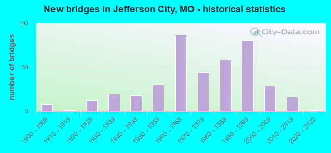
- New bridges - historical statistics
- 81900-1909
- 11910-1919
- 121920-1929
- 201930-1939
- 181940-1949
- 301950-1959
- 871960-1969
- 441970-1979
- 591980-1989
- 811990-1999
- 292000-2009
- 162010-2019
- 12020-2022
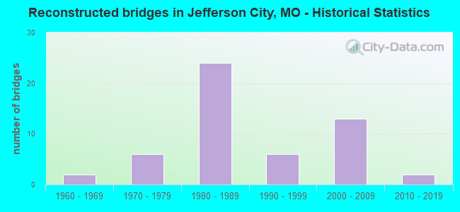
- Reconstructed bridges - Historical Statistics
- 21960-1969
- 61970-1979
- 241980-1989
- 61990-1999
- 132000-2009
- 22010-2019
- Bridge Condition - Deck
- 1.7%Excellent
- 9.6%Very good
- 43.1%Good
- 25.9%Satisfactory
- 11.3%Fair
- 6.3%Poor
- 2.1%Serious
- Bridge Condition - Superstructure
- 2.5%Excellent
- 11.6%Very good
- 42.3%Good
- 27.0%Satisfactory
- 10.0%Fair
- 5.8%Poor
- 0.8%Serious
- 0.4%Critical
- Bridge Condition - Substructure
- 5.8%Excellent
- 11.6%Very good
- 29.5%Good
- 29.5%Satisfactory
- 17.4%Fair
- 5.0%Poor
- 1.2%Serious
- Bridge Condition - Channel
- 3.1%Excellent
- 2.0%Very good
- 16.0%Good
- 43.0%Satisfactory
- 30.5%Fair
- 5.1%Poor
- 0.4%Serious
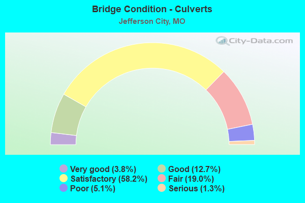
- Bridge Condition - Culverts
- 3.8%Very good
- 12.7%Good
- 58.2%Satisfactory
- 19.0%Fair
- 5.1%Poor
- 1.3%Serious
Find on map >> Show street view
Structure Number: 5929, Location: S 26 T 44 N R 12 W (Lat: 38.527333, Lng: -92.222281), Route carried "on" structure: US 54, Year Built: 1941, Year Reconstructed: 1965, Status: Open, Structure Length: 1.15m (3.77ft), Average Daily Traffic: 34,046 (year 2021), Truck Traffic: 16%, Average Future Daily Traffic: 59,581 (year 2041), Design Load: H 20, Features Intersected: HAMANN BR
Minimum Vertical Clearance: 30+ m (98+ ft), Kilometerpoint: 263.741, Lanes on structure: 6, Base Highway Network: Yes, Owner: State Highway Agency, Approaching Roadway Width: 11.3m (37.1ft), Skew: 25 degrees, Material/Design: Concrete continuous, Design/Construction: Culvert, Number Of Spans In Main Unit: 2, Length of Maximum Span: 3.0m (9.8ft)
Condition: Channel: Satisfactory, Culverts: Satisfactory, Operating Rating: 47.7 metric tons, Method Used To Determine Operating Rating: Load Factor (LF), Inventory Rating: 28.8 metric tons, Method Used To Determine Inventory Rating: Load Factor (LF), Structural Evaluation: Equal to present minimum criteria, Waterway Adequacy: Equal to present desirable criteria, Approach Roadway Alignment: Equal to present desirable criteria, Designated Inspection Frequency: Every 24 months, Inspection Date: July 2020
Find on map >> Show street view
Structure Number: 6014, Location: S 20 T 29 N R 6 W (Lat: 37.173297, Lng: -91.621978), Route carried "on" structure: State highway 106, Year Built: 1941, Status: Open, Structure Length: 5.52m (18.11ft), Average Daily Traffic: 584 (year 2021), Truck Traffic: 9%, Average Future Daily Traffic: 876 (year 2041), Design Load: H 15, Features Intersected: SPRING VALLEY CR
Minimum Vertical Clearance: 30+ m (98+ ft), Kilometerpoint: 3.772, Lanes on structure: 2, Base Highway Network: Yes, Owner: State Highway Agency, Approaching Roadway Width: 6.7m (22.0ft), Skew: 2 degrees, Material/Design: Steel, Design/Construction: Stringer/Multi-beam, Number Of Spans In Main Unit: 4, Length of Maximum Span: 15.3m (50.2ft), Curb-To-Curb Width: 7.3m (24.0ft), Out-to-Out Width: 8.1m (26.6ft)
Condition: Deck: Fair, Superstructure: Fair, Substructure: Fair, Channel: Satisfactory, Operating Rating: 30.6 metric tons, Method Used To Determine Operating Rating: Allowable Stress (AS), Inventory Rating: 17.1 metric tons, Method Used To Determine Inventory Rating: Allowable Stress (AS), Structural Evaluation: Meets minimum limits, Deck Geometry: Meets minimum limits, Waterway Adequacy: Equal to present desirable criteria, Approach Roadway Alignment: Equal to present desirable criteria, Designated Inspection Frequency: Every 24 months, Inspection Date: December 2020, Deck Structure Type: Concrete Cast-file-Place, Wearing Surface/Protective System: Wearing Surface: Bituminous
Find on map >> Show street view
Structure Number: 6345, Location: S 7 T 44 N R 11 W (Lat: 38.589611, Lng: -92.176828), Route carried "on" structure: US 54, Year Built: 1955, Status: Open, Structure Length: 94.31m (309.42ft), Average Daily Traffic: 27,922 (year 2021), Truck Traffic: 16%, Average Future Daily Traffic: 51,656 (year 2041), Design Load: HS 20, Features Intersected: MISSOURI RVR, UP RR
Minimum Vertical Clearance: 4.55m (14.93ft), Kilometerpoint: 164.781, Lanes on structure: 3, Base Highway Network: Yes, Owner: State Highway Agency, Approaching Roadway Width: 14.6m (47.9ft), Navigation Control: Yes ( Vertical Clearance: 16.8m (55.1ft), Horizontal Clearance: 123.4m (404.9ft)), Material/Design: Steel continuous, Design/Construction: Arch - Thru, Number Of Spans In Main Unit: 3, Number Of Approach Spans: 15, Length of Maximum Span: 195.1m (640.1ft), Curb-To-Curb Width: 11.5m (37.7ft), Out-to-Out Width: 12.5m (41.0ft)
Condition: Deck: Good, Superstructure: Fair, Substructure: Fair, Channel: Good, Operating Rating: 51.3 metric tons, Method Used To Determine Operating Rating: Load Factor (LF), Inventory Rating: 30.6 metric tons, Method Used To Determine Inventory Rating: Load Factor (LF), Structural Evaluation: Somewhat better than minimum adequacy, Deck Geometry: High priority of replacement, Underclear: Somewhat better than minimum adequacy, Waterway Adequacy: Equal to present desirable criteria, Approach Roadway Alignment: Equal to present minimum criteria, Length Of Structure Improvement: 9.43m (30.94ft), Designated Inspection Frequency: Every 24 months, Critical Feature Inspection Frequency: Every 24 months, Underwater Inspection Frequency: Every 60 months, Other Special Inspection Frequency: Every 24 months, Inspection Date: August 2020, Critical Feature Inspection Date: August 2020, Underwater Inspection Date: June 2017, Other Special Inspection Date: August 2020, Bridge Improvement Cost: $44,806,000, Roadway Improvement Cost: $4,481,000, Total Project Cost: $67,209,000 ( Estimate for 2022), Deck Structure Type: Concrete Cast-file-Place, Wearing Surface/Protective System: Wearing Surface: Monolithic Concrete, Deck Protection: Epoxy Coated Reinforcing
Find on map >> Show street view
Structure Number: 6589, Location: S 10 T 44 N R 11 W (Lat: 38.606981, Lng: -92.158075), Route carried "on" structure: US 54, Year Built: 1957, Year Reconstructed: 1978, Status: Open, Structure Length: 0.85m (2.79ft), Average Daily Traffic: 29,922 (year 2021), Truck Traffic: 11%, Average Future Daily Traffic: 55,356 (year 2041), Design Load: HS 20, Features Intersected: HALIFAX BR
Minimum Vertical Clearance: 30+ m (98+ ft), Kilometerpoint: 274.703, Lanes on structure: 5, Base Highway Network: Yes, Owner: State Highway Agency, Approaching Roadway Width: 12.2m (40.0ft), Skew: 23 degrees, Material/Design: Concrete continuous, Design/Construction: Culvert, Number Of Spans In Main Unit: 2, Length of Maximum Span: 3.4m (11.2ft)
Condition: Channel: Fair, Culverts: Fair, Operating Rating: 92.7 metric tons, Method Used To Determine Operating Rating: Load Factor (LF), Inventory Rating: 54.9 metric tons, Method Used To Determine Inventory Rating: Load Factor (LF), Structural Evaluation: Somewhat better than minimum adequacy, Waterway Adequacy: Equal to present desirable criteria, Approach Roadway Alignment: Equal to present desirable criteria, Designated Inspection Frequency: Every 24 months, Inspection Date: October 2020
Find on map >> Show street view
Structure Number: 659, Location: S 10 T 44 N R 11 W (Lat: 38.605458, Lng: -92.161308), Route carried "on" structure: US 54, Year Built: 1957, Year Reconstructed: 1991, Status: Open, Structure Length: 4.45m (14.60ft), Average Daily Traffic: 16,149 (year 2021), Truck Traffic: 17%, Average Future Daily Traffic: 29,876 (year 2041), Design Load: H 20, Features Intersected: KATY TRAIL
Minimum Vertical Clearance: 30+ m (98+ ft), Kilometerpoint: 163.011, Lanes on structure: 2, Base Highway Network: Yes, Owner: State Highway Agency, Approaching Roadway Width: 11.6m (38.1ft), Skew: 1 degrees, Material/Design: Steel continuous, Design/Construction: Stringer/Multi-beam, Number Of Spans In Main Unit: 3, Length of Maximum Span: 16.5m (54.1ft), Curb or Sidewalk Widths: Left: 0.2m (0.7ft), Right: 0.2m (0.7ft), Curb-To-Curb Width: 11.2m (36.7ft), Out-to-Out Width: 12.0m (39.4ft)
Condition: Deck: Good, Superstructure: Satisfactory, Substructure: Good, Operating Rating: 43.2 metric tons, Method Used To Determine Operating Rating: Load Factor (LF), Inventory Rating: 26.1 metric tons, Method Used To Determine Inventory Rating: Load Factor (LF), Structural Evaluation: Equal to present minimum criteria, Deck Geometry: Somewhat better than minimum adequacy, Approach Roadway Alignment: Equal to present desirable criteria, Designated Inspection Frequency: Every 24 months, Inspection Date: October 2020, Deck Structure Type: Concrete Cast-file-Place, Wearing Surface/Protective System: Wearing Surface: Monolithic Concrete, Deck Protection: Epoxy Coated Reinforcing
Find on map >> Show street view
Structure Number: 7037, Location: S 24 T 48 N R 4 W (Lat: 38.904744, Lng: -91.300858), Route carried "on" structure: State highway FF, Year Built: 1961, Status: Open, Structure Length: 0.66m (2.17ft), Average Daily Traffic: 136 (year 2021), Truck Traffic: 13%, Average Future Daily Traffic: 197 (year 2041), Design Load: H 10, Features Intersected: BEAR CR
Minimum Vertical Clearance: 30+ m (98+ ft), Kilometerpoint: 9.860, Lanes on structure: 2, Owner: State Highway Agency, Approaching Roadway Width: 7.3m (24.0ft), Skew: 1 degrees, Material/Design: Concrete continuous, Design/Construction: Culvert, Number Of Spans In Main Unit: 2, Length of Maximum Span: 3.0m (9.8ft), Curb-To-Curb Width: 7.8m (25.6ft), Out-to-Out Width: 8.4m (27.6ft)
Condition: Channel: Satisfactory, Culverts: Satisfactory, Operating Rating: 54.0 metric tons, Method Used To Determine Operating Rating: Load Factor (LF), Inventory Rating: 32.4 metric tons, Method Used To Determine Inventory Rating: Load Factor (LF), Structural Evaluation: Equal to present minimum criteria, Deck Geometry: Somewhat better than minimum adequacy, Waterway Adequacy: Equal to present minimum criteria, Approach Roadway Alignment: Equal to present desirable criteria, Designated Inspection Frequency: Every 24 months, Inspection Date: September 2020
Find on map >> Show street view
Structure Number: 7491, Location: S 23 T 52 N R 10 W (Lat: 39.268714, Lng: -92.105153), Route carried "on" structure: State highway T, Year Built: 1950, Status: Open, Structure Length: 0.76m (2.49ft), Average Daily Traffic: 458 (year 2021), Truck Traffic: 13%, Average Future Daily Traffic: 664 (year 2041), Design Load: H 10, Features Intersected: ELM CR
Minimum Vertical Clearance: 30+ m (98+ ft), Kilometerpoint: 1.875, Lanes on structure: 2, Owner: State Highway Agency, Approaching Roadway Width: 7.3m (24.0ft), Material/Design: Concrete continuous, Design/Construction: Culvert, Number Of Spans In Main Unit: 2, Length of Maximum Span: 3.7m (12.1ft), Curb-To-Curb Width: 6.6m (21.7ft), Out-to-Out Width: 7.2m (23.6ft)
Condition: Channel: Satisfactory, Culverts: Satisfactory, Operating Rating: 37.8 metric tons, Method Used To Determine Operating Rating: Load Factor (LF), Inventory Rating: 22.5 metric tons, Method Used To Determine Inventory Rating: Load Factor (LF), Structural Evaluation: Equal to present minimum criteria, Deck Geometry: High priority of corrective action, Waterway Adequacy: Equal to present minimum criteria, Approach Roadway Alignment: Equal to present desirable criteria, Length Of Structure Improvement: 0.14m (0.46ft), Designated Inspection Frequency: Every 24 months, Inspection Date: October 2021, Bridge Improvement Cost: $170,000, Roadway Improvement Cost: $17,000, Total Project Cost: $255,000 ( Estimate for 2022)
Find on map >> Show street view
Structure Number: 7725, Location: S 3 T 58 N R 22 W (Lat: 39.880239, Lng: -93.354467), Route carried "on" structure: State highway B, Year Built: 1954, Status: Open, Structure Length: 1.07m (3.51ft), Average Daily Traffic: 107 (year 2021), Truck Traffic: 13%, Average Future Daily Traffic: 134 (year 2041), Design Load: H 10, Features Intersected: COON CR
Minimum Vertical Clearance: 30+ m (98+ ft), Kilometerpoint: 13.876, Lanes on structure: 2, Owner: State Highway Agency, Approaching Roadway Width: 7.3m (24.0ft), Skew: 1 degrees, Material/Design: Concrete continuous, Design/Construction: Culvert, Number Of Spans In Main Unit: 3, Length of Maximum Span: 3.4m (11.2ft), Curb-To-Curb Width: 7.3m (24.0ft), Out-to-Out Width: 7.9m (25.9ft)
Condition: Channel: Satisfactory, Culverts: Satisfactory, Operating Rating: 45.9 metric tons, Method Used To Determine Operating Rating: Load Factor (LF), Inventory Rating: 27.9 metric tons, Method Used To Determine Inventory Rating: Load Factor (LF), Structural Evaluation: Equal to present minimum criteria, Deck Geometry: Somewhat better than minimum adequacy, Waterway Adequacy: Equal to present minimum criteria, Approach Roadway Alignment: Equal to present desirable criteria, Designated Inspection Frequency: Every 24 months, Inspection Date: December 2020
Find on map >> Show street view
Structure Number: 7734, Location: S 6 T 62 N R 37 W (Lat: 40.202922, Lng: -95.120817), Route carried "on" structure: State highway C, Year Built: 1954, Status: Open, Structure Length: 0.82m (2.69ft), Average Daily Traffic: 366 (year 2021), Truck Traffic: 12%, Average Future Daily Traffic: 476 (year 2041), Design Load: H 10, Features Intersected: HIGHLY CR
Minimum Vertical Clearance: 30+ m (98+ ft), Kilometerpoint: 21.794, Lanes on structure: 2, Owner: State Highway Agency, Approaching Roadway Width: 7.3m (24.0ft), Skew: 2 degrees, Material/Design: Concrete continuous, Design/Construction: Culvert, Number Of Spans In Main Unit: 2, Length of Maximum Span: 3.7m (12.1ft), Curb-To-Curb Width: 8.2m (26.9ft), Out-to-Out Width: 8.8m (28.9ft)
Condition: Channel: Fair, Culverts: Fair, Operating Rating: 45.9 metric tons, Method Used To Determine Operating Rating: Load Factor (LF), Inventory Rating: 27.9 metric tons, Method Used To Determine Inventory Rating: Load Factor (LF), Structural Evaluation: Somewhat better than minimum adequacy, Deck Geometry: Somewhat better than minimum adequacy, Waterway Adequacy: Equal to present minimum criteria, Approach Roadway Alignment: Equal to present desirable criteria, Designated Inspection Frequency: Every 24 months, Inspection Date: January 2022
Find on map >> Show street view
Structure Number: 7736, Location: S 21 T 66 N R 8 W (Lat: 40.515969, Lng: -91.787206), Route carried "on" structure: State highway NN, Year Built: 1954, Status: Open, Structure Length: 0.83m (2.72ft), Average Daily Traffic: 76 (year 2021), Truck Traffic: 8%, Average Future Daily Traffic: 110 (year 2041), Design Load: H 10, Features Intersected: TRIB TO FOX RVR
Minimum Vertical Clearance: 30+ m (98+ ft), Kilometerpoint: 14.426, Lanes on structure: 2, Owner: State Highway Agency, Approaching Roadway Width: 7.3m (24.0ft), Skew: 2 degrees, Material/Design: Concrete continuous, Design/Construction: Culvert, Number Of Spans In Main Unit: 2, Length of Maximum Span: 3.7m (12.1ft), Curb-To-Curb Width: 7.8m (25.6ft), Out-to-Out Width: 8.4m (27.6ft)
Condition: Channel: Satisfactory, Culverts: Satisfactory, Operating Rating: 36.0 metric tons, Method Used To Determine Operating Rating: Load Factor (LF), Inventory Rating: 21.6 metric tons, Method Used To Determine Inventory Rating: Load Factor (LF), Structural Evaluation: Equal to present minimum criteria, Deck Geometry: Equal to present minimum criteria, Waterway Adequacy: Equal to present minimum criteria, Approach Roadway Alignment: Equal to present minimum criteria, Designated Inspection Frequency: Every 24 months, Inspection Date: November 2021
Find on map >> Show street view
Structure Number: 7737, Location: S 22 T 66 N R 8 W (Lat: 40.510053, Lng: -91.768606), Route carried "on" structure: State highway NN, Year Built: 1954, Year Reconstructed: 2010, Status: Open, Structure Length: 8.17m (26.80ft), Average Daily Traffic: 76 (year 2021), Truck Traffic: 8%, Average Future Daily Traffic: 110 (year 2041), Design Load: H 10, Features Intersected: FOX RVR
Minimum Vertical Clearance: 30+ m (98+ ft), Kilometerpoint: 16.200, Lanes on structure: 2, Owner: State Highway Agency, Approaching Roadway Width: 6.7m (22.0ft), Material/Design: Steel continuous, Design/Construction: Stringer/Multi-beam, Number Of Spans In Main Unit: 3, Number Of Approach Spans: 2, Length of Maximum Span: 22.9m (75.1ft), Curb-To-Curb Width: 6.7m (22.0ft), Out-to-Out Width: 7.5m (24.6ft)
Condition: Deck: Very good, Superstructure: Good, Substructure: Good, Channel: Satisfactory, Operating Rating: 35.1 metric tons, Method Used To Determine Operating Rating: Load Factor (LF), Inventory Rating: 20.7 metric tons, Method Used To Determine Inventory Rating: Load Factor (LF), Structural Evaluation: Equal to present minimum criteria, Deck Geometry: Somewhat better than minimum adequacy, Waterway Adequacy: Equal to present minimum criteria, Approach Roadway Alignment: Equal to present minimum criteria, Designated Inspection Frequency: Every 24 months, Inspection Date: November 2021, Deck Structure Type: Concrete Cast-file-Place, Wearing Surface/Protective System: Wearing Surface: Monolithic Concrete, Deck Protection: Epoxy Coated Reinforcing
Find on map >> Show street view
Structure Number: 7768, Location: S 22 T 66 N R 12 W (Lat: 40.513939, Lng: -92.228533), Route carried "on" structure: State highway CC, Year Built: 1956, Status: Open, Structure Length: 0.69m (2.26ft), Average Daily Traffic: 86 (year 2021), Truck Traffic: 12%, Average Future Daily Traffic: 125 (year 2041), Design Load: H 10, Features Intersected: PONY CR
Minimum Vertical Clearance: 30+ m (98+ ft), Kilometerpoint: 5.049, Lanes on structure: 2, Owner: State Highway Agency, Approaching Roadway Width: 7.3m (24.0ft), Material/Design: Concrete continuous, Design/Construction: Culvert, Number Of Spans In Main Unit: 2, Length of Maximum Span: 3.4m (11.2ft), Curb-To-Curb Width: 7.9m (25.9ft), Out-to-Out Width: 8.5m (27.9ft)
Condition: Channel: Satisfactory, Culverts: Satisfactory, Operating Rating: 36.9 metric tons, Method Used To Determine Operating Rating: Load Factor (LF), Inventory Rating: 22.5 metric tons, Method Used To Determine Inventory Rating: Load Factor (LF), Structural Evaluation: Equal to present minimum criteria, Deck Geometry: Equal to present minimum criteria, Waterway Adequacy: Equal to present minimum criteria, Approach Roadway Alignment: Meets minimum limits, Designated Inspection Frequency: Every 24 months, Inspection Date: October 2020
Find on map >> Show street view
Structure Number: 7794, Location: S 3 T 34 N R 33 W (Lat: 37.724869, Lng: -94.533853), Route carried "on" structure: State highway FF, Year Built: 1954, Status: Open, Structure Length: 0.63m (2.07ft), Average Daily Traffic: 185 (year 2021), Truck Traffic: 20%, Average Future Daily Traffic: 259 (year 2041), Design Load: H 10, Features Intersected: DRYWOOD CR
Minimum Vertical Clearance: 30+ m (98+ ft), Kilometerpoint: 7.601, Lanes on structure: 2, Owner: State Highway Agency, Approaching Roadway Width: 7.3m (24.0ft), Material/Design: Concrete continuous, Design/Construction: Culvert, Number Of Spans In Main Unit: 2, Length of Maximum Span: 3.0m (9.8ft), Curb-To-Curb Width: 8.7m (28.5ft), Out-to-Out Width: 9.3m (30.5ft)
Condition: Channel: Fair, Culverts: Satisfactory, Operating Rating: 35.1 metric tons, Method Used To Determine Operating Rating: Load Factor (LF), Inventory Rating: 20.7 metric tons, Method Used To Determine Inventory Rating: Load Factor (LF), Structural Evaluation: Equal to present minimum criteria, Deck Geometry: Equal to present minimum criteria, Waterway Adequacy: Equal to present minimum criteria, Approach Roadway Alignment: Equal to present desirable criteria, Designated Inspection Frequency: Every 24 months, Inspection Date: March 2022
Find on map >> Show street view
Structure Number: 7799, Location: S 8 T 44 N R 6 W (Lat: 38.583314, Lng: -91.627517), Route carried "on" structure: State highway OO, Year Built: 1954, Status: Open, Structure Length: 1.15m (3.77ft), Average Daily Traffic: 130 (year 2021), Truck Traffic: 8%, Average Future Daily Traffic: 169 (year 2041), Design Load: H 10, Features Intersected: RICHLAND CR
Minimum Vertical Clearance: 30+ m (98+ ft), Kilometerpoint: 2.670, Lanes on structure: 2, Owner: State Highway Agency, Approaching Roadway Width: 7.3m (24.0ft), Material/Design: Concrete continuous, Design/Construction: Culvert, Number Of Spans In Main Unit: 3, Length of Maximum Span: 3.7m (12.1ft)
Condition: Channel: Fair, Culverts: Satisfactory, Operating Rating: 43.2 metric tons, Method Used To Determine Operating Rating: Load Factor (LF), Inventory Rating: 26.1 metric tons, Method Used To Determine Inventory Rating: Load Factor (LF), Structural Evaluation: Equal to present minimum criteria, Waterway Adequacy: Equal to present desirable criteria, Approach Roadway Alignment: Equal to present desirable criteria, Designated Inspection Frequency: Every 24 months, Inspection Date: November 2020
Find on map >> Show street view
Structure Number: 8744, Location: S 11 T 22 N R 5 E (Lat: 36.561342, Lng: -90.496311), Route carried "on" structure: State highway 142, Year Built: 1932, Status: Posted for load, Structure Length: 2.01m (6.59ft), Average Daily Traffic: 391 (year 2021), Truck Traffic: 12%, Average Future Daily Traffic: 626 (year 2041), Design Load: H 10, Features Intersected: CANE CR
Minimum Vertical Clearance: 30+ m (98+ ft), Kilometerpoint: 168.204, Lanes on structure: 1, Base Highway Network: Yes, Owner: State Highway Agency, Approaching Roadway Width: 6.1m (20.0ft), Skew: 1 degrees, Material/Design: Steel, Design/Construction: Stringer/Multi-beam, Number Of Spans In Main Unit: 3, Length of Maximum Span: 6.4m (21.0ft), Curb-To-Curb Width: 6.1m (20.0ft), Out-to-Out Width: 6.4m (21.0ft)
Condition: Deck: Poor, Superstructure: Fair, Substructure: Fair, Channel: Fair, Operating Rating: 23.4 metric tons, Method Used To Determine Operating Rating: Load Factor (LF), Inventory Rating: 14.4 metric tons, Method Used To Determine Inventory Rating: Load Factor (LF), Structural Evaluation: Meets minimum limits, Deck Geometry: Meets minimum limits, Waterway Adequacy: Equal to present minimum criteria, Approach Roadway Alignment: Equal to present desirable criteria, Bridge Posting: Required (Relationship of Operating Rating to Maximum Legal Load: 30.0 - 39.9% below), Length Of Structure Improvement: 0.28m (0.92ft), Designated Inspection Frequency: Every 12 months, Inspection Date: Febuary 2022, Bridge Improvement Cost: $218,000, Roadway Improvement Cost: $22,000, Total Project Cost: $327,000 ( Estimate for 2022), Deck Structure Type: Concrete Cast-file-Place, Wearing Surface/Protective System: Wearing Surface: Bituminous
Find on map >> Show street view
Structure Number: 8809, Location: S 29 T 51 N R 28 W (Lat: 39.201592, Lng: -94.069756), Route carried "on" structure: State highway T, Year Built: 1933, Status: Posted for load, Structure Length: 1.46m (4.79ft), Average Daily Traffic: 410 (year 2021), Truck Traffic: 11%, Average Future Daily Traffic: 595 (year 2041), Design Load: H 10, Features Intersected: PANTHER CR
Minimum Vertical Clearance: 30+ m (98+ ft), Kilometerpoint: 4.134, Lanes on structure: 1, Owner: State Highway Agency, Approaching Roadway Width: 6.7m (22.0ft), Skew: 1 degrees, Material/Design: Steel, Design/Construction: Stringer/Multi-beam, Number Of Spans In Main Unit: 1, Length of Maximum Span: 13.7m (44.9ft), Curb-To-Curb Width: 6.1m (20.0ft), Out-to-Out Width: 6.4m (21.0ft)
Condition: Deck: Poor, Superstructure: Fair, Substructure: Satisfactory, Channel: Satisfactory, Operating Rating: 18.9 metric tons, Method Used To Determine Operating Rating: Allowable Stress (AS), Inventory Rating: 9.0 metric tons, Method Used To Determine Inventory Rating: Allowable Stress (AS), Structural Evaluation: High priority of replacement, Deck Geometry: High priority of corrective action, Waterway Adequacy: Equal to present minimum criteria, Approach Roadway Alignment: Equal to present minimum criteria, Bridge Posting: Required (Relationship of Operating Rating to Maximum Legal Load: 20.0 - 29.9% below), Length Of Structure Improvement: 0.21m (0.69ft), Designated Inspection Frequency: Every 12 months, Inspection Date: November 2021, Bridge Improvement Cost: $240,000, Roadway Improvement Cost: $24,000, Total Project Cost: $360,000 ( Estimate for 2022), Deck Structure Type: Concrete Cast-file-Place, Wearing Surface/Protective System: Wearing Surface: Bituminous
Find on map >> Show street view
Structure Number: 8855, Location: S 34 T 23 N R 3 E (Lat: 36.595258, Lng: -90.726456), Route carried "on" structure: State highway 142, Year Built: 1933, Status: Posted for load, Structure Length: 2.74m (8.99ft), Average Daily Traffic: 1,126 (year 2021), Truck Traffic: 12%, Average Future Daily Traffic: 1,689 (year 2041), Design Load: H 10, Features Intersected: HARRIS CR
Minimum Vertical Clearance: 30+ m (98+ ft), Kilometerpoint: 144.159, Lanes on structure: 1, Base Highway Network: Yes, Owner: State Highway Agency, Approaching Roadway Width: 6.1m (20.0ft), Skew: 1 degrees, Material/Design: Steel, Design/Construction: Stringer/Multi-beam, Number Of Spans In Main Unit: 3, Length of Maximum Span: 13.8m (45.3ft), Curb-To-Curb Width: 6.1m (20.0ft), Out-to-Out Width: 6.4m (21.0ft)
Condition: Deck: Poor, Superstructure: Fair, Substructure: Fair, Channel: Satisfactory, Operating Rating: 18.9 metric tons, Method Used To Determine Operating Rating: Load Factor (LF), Inventory Rating: 10.8 metric tons, Method Used To Determine Inventory Rating: Load Factor (LF), Structural Evaluation: High priority of replacement, Deck Geometry: High priority of replacement, Waterway Adequacy: Equal to present minimum criteria, Approach Roadway Alignment: Equal to present minimum criteria, Bridge Posting: Required (Relationship of Operating Rating to Maximum Legal Load: 20.0 - 29.9% below), Length Of Structure Improvement: 0.37m (1.21ft), Designated Inspection Frequency: Every 24 months, Inspection Date: January 2022, Bridge Improvement Cost: $421,000, Roadway Improvement Cost: $42,000, Total Project Cost: $632,000 ( Estimate for 2022), Deck Structure Type: Concrete Cast-file-Place, Wearing Surface/Protective System: Wearing Surface: Bituminous
Find on map >> Show street view
Structure Number: 8894, Location: S 28 T 27 N R 26 W (Lat: 37.021967, Lng: -93.789147), Route carried "on" structure: State highway P, Year Built: 1935, Status: Open, Structure Length: 0.63m (2.07ft), Average Daily Traffic: 781 (year 2021), Truck Traffic: 18%, Average Future Daily Traffic: 1,132 (year 2041), Design Load: H 10, Features Intersected: DRY BR
Minimum Vertical Clearance: 30+ m (98+ ft), Kilometerpoint: 1.500, Lanes on structure: 2, Owner: State Highway Agency, Approaching Roadway Width: 7.3m (24.0ft), Material/Design: Concrete continuous, Design/Construction: Culvert, Number Of Spans In Main Unit: 2, Length of Maximum Span: 3.0m (9.8ft), Curb-To-Curb Width: 8.4m (27.6ft), Out-to-Out Width: 9.0m (29.5ft)
Condition: Channel: Satisfactory, Culverts: Satisfactory, Operating Rating: 37.8 metric tons, Method Used To Determine Operating Rating: Load Factor (LF), Inventory Rating: 22.5 metric tons, Method Used To Determine Inventory Rating: Load Factor (LF), Structural Evaluation: Equal to present minimum criteria, Deck Geometry: Somewhat better than minimum adequacy, Waterway Adequacy: Equal to present desirable criteria, Approach Roadway Alignment: Equal to present desirable criteria, Designated Inspection Frequency: Every 24 months, Inspection Date: April 2021
Find on map >> Show street view
Structure Number: 8895, Location: S 28 T 31 N R 30 W (Lat: 37.396483, Lng: -94.229469), Route carried "on" structure: State highway 126, Year Built: 1933, Status: Open, Structure Length: 0.80m (2.62ft), Average Daily Traffic: 1,275 (year 2021), Truck Traffic: 13%, Average Future Daily Traffic: 1,849 (year 2041), Design Load: H 10, Features Intersected: DRY BR
Minimum Vertical Clearance: 30+ m (98+ ft), Kilometerpoint: 34.361, Lanes on structure: 2, Owner: State Highway Agency, Approaching Roadway Width: 7.3m (24.0ft), Skew: 2 degrees, Material/Design: Concrete continuous, Design/Construction: Culvert, Number Of Spans In Main Unit: 2, Length of Maximum Span: 3.7m (12.1ft), Curb-To-Curb Width: 8.1m (26.6ft), Out-to-Out Width: 8.7m (28.5ft)
Condition: Channel: Fair, Culverts: Satisfactory, Operating Rating: 39.6 metric tons, Method Used To Determine Operating Rating: Load Factor (LF), Inventory Rating: 23.4 metric tons, Method Used To Determine Inventory Rating: Load Factor (LF), Structural Evaluation: Equal to present minimum criteria, Deck Geometry: Meets minimum limits, Waterway Adequacy: Equal to present minimum criteria, Approach Roadway Alignment: Equal to present desirable criteria, Designated Inspection Frequency: Every 24 months, Inspection Date: April 2020
Find on map >> Show street view
Structure Number: 8906, Location: S 35 T 35 N R 6 W (Lat: 37.702794, Lng: -91.550061), Route carried "on" structure: State highway 68, Year Built: 1933, Status: Open, Structure Length: 0.65m (2.13ft), Average Daily Traffic: 1,666 (year 2021), Truck Traffic: 11%, Average Future Daily Traffic: 2,332 (year 2041), Design Load: H 10, Features Intersected: BR SPRING CR
Minimum Vertical Clearance: 30+ m (98+ ft), Kilometerpoint: 57.496, Lanes on structure: 2, Owner: State Highway Agency, Approaching Roadway Width: 7.3m (24.0ft), Skew: 1 degrees, Material/Design: Concrete continuous, Design/Construction: Culvert, Number Of Spans In Main Unit: 2, Length of Maximum Span: 3.0m (9.8ft), Curb-To-Curb Width: 8.1m (26.6ft), Out-to-Out Width: 8.7m (28.5ft)
Condition: Channel: Satisfactory, Culverts: Fair, Operating Rating: 38.7 metric tons, Method Used To Determine Operating Rating: Load Factor (LF), Inventory Rating: 23.4 metric tons, Method Used To Determine Inventory Rating: Load Factor (LF), Structural Evaluation: Somewhat better than minimum adequacy, Deck Geometry: Meets minimum limits, Waterway Adequacy: Equal to present desirable criteria, Approach Roadway Alignment: Equal to present minimum criteria, Designated Inspection Frequency: Every 24 months, Inspection Date: Febuary 2022
Find on map >> Show street view
Structure Number: 9398, Location: S 10 T 44 N R 11 W (Lat: 38.608753, Lng: -92.146389), Route carried "on" structure: ServiceOther road , Year Built: 1982, Status: Open, Structure Length: 1.95m (6.40ft), Average Daily Traffic: 10 (year 2021), Truck Traffic: 10%, Average Future Daily Traffic: 16 (year 2041), Features Intersected: CR, Facility Carried by Structure: PVT BRIDGE T1012 S
Minimum Vertical Clearance: 30+ m (98+ ft), Kilometerpoint: 0.006, Lanes on structure: 1, Owner: State Highway Agency, Approaching Roadway Width: 3.7m (12.1ft), Material/Design: Steel, Design/Construction: Stringer/Multi-beam, Number Of Spans In Main Unit: 2, Length of Maximum Span: 9.7m (31.8ft), Curb or Sidewalk Widths: Left: 0.2m (0.7ft), Right: 0.2m (0.7ft), Curb-To-Curb Width: 3.2m (10.5ft), Out-to-Out Width: 3.7m (12.1ft)
Condition: Deck: Fair, Superstructure: Fair, Substructure: Satisfactory, Channel: Good, Operating Rating: 49.5 metric tons, Method Used To Determine Operating Rating: Load Factor (LF), Inventory Rating: 29.7 metric tons, Method Used To Determine Inventory Rating: Load Factor (LF), Structural Evaluation: Somewhat better than minimum adequacy, Deck Geometry: High priority of replacement, Waterway Adequacy: Equal to present desirable criteria, Approach Roadway Alignment: Equal to present desirable criteria, Length Of Structure Improvement: 0.27m (0.89ft), Designated Inspection Frequency: Every 24 months, Inspection Date: October 2020, Bridge Improvement Cost: $145,000, Roadway Improvement Cost: $15,000, Total Project Cost: $218,000 ( Estimate for 2022), Deck Structure Type: Wood or Timber, Wearing Surface/Protective System: Wearing Surface: Wood or Timber
Find on map >> Show street view
Structure Number: 9496, Location: S 31 T 33 N R 32 W (Lat: 37.563925, Lng: -94.492522), Route carried "on" structure: State highway K, Year Built: 1934, Status: Open, Structure Length: 1.22m (4.00ft), Average Daily Traffic: 1,152 (year 2021), Truck Traffic: 11%, Average Future Daily Traffic: 1,670 (year 2041), Design Load: H 10, Features Intersected: BR OF WOOD CR
Minimum Vertical Clearance: 30+ m (98+ ft), Kilometerpoint: 19.298, Lanes on structure: 2, Owner: State Highway Agency, Approaching Roadway Width: 7.3m (24.0ft), Skew: 2 degrees, Material/Design: Concrete continuous, Design/Construction: Culvert, Number Of Spans In Main Unit: 3, Length of Maximum Span: 3.7m (12.1ft), Curb-To-Curb Width: 7.3m (24.0ft), Out-to-Out Width: 8.1m (26.6ft)
Condition: Channel: Fair, Culverts: Fair, Operating Rating: 36.9 metric tons, Method Used To Determine Operating Rating: Load Factor (LF), Inventory Rating: 22.5 metric tons, Method Used To Determine Inventory Rating: Load Factor (LF), Structural Evaluation: Somewhat better than minimum adequacy, Deck Geometry: Meets minimum limits, Waterway Adequacy: Equal to present minimum criteria, Approach Roadway Alignment: Equal to present desirable criteria, Designated Inspection Frequency: Every 24 months, Inspection Date: April 2020
Find on map >> Show street view
Structure Number: 9497, Location: S 4 T 26 N R 30 W (Lat: 36.993917, Lng: -94.218361), Route carried "on" structure: State highway J, Year Built: 1934, Status: Open, Structure Length: 1.60m (5.25ft), Average Daily Traffic: 682 (year 2021), Truck Traffic: 11%, Average Future Daily Traffic: 1,125 (year 2041), Design Load: H 10, Features Intersected: JONES CR
Minimum Vertical Clearance: 30+ m (98+ ft), Kilometerpoint: 8.694, Lanes on structure: 2, Owner: State Highway Agency, Approaching Roadway Width: 7.3m (24.0ft), Skew: 4 degrees, Material/Design: Concrete continuous, Design/Construction: Culvert, Number Of Spans In Main Unit: 3, Length of Maximum Span: 3.7m (12.1ft), Curb-To-Curb Width: 8.8m (28.9ft), Out-to-Out Width: 9.4m (30.8ft)
Condition: Channel: Fair, Culverts: Satisfactory, Operating Rating: 45.0 metric tons, Method Used To Determine Operating Rating: Load Factor (LF), Inventory Rating: 27.0 metric tons, Method Used To Determine Inventory Rating: Load Factor (LF), Structural Evaluation: Equal to present minimum criteria, Deck Geometry: Somewhat better than minimum adequacy, Waterway Adequacy: Equal to present desirable criteria, Approach Roadway Alignment: Equal to present minimum criteria, Designated Inspection Frequency: Every 24 months, Inspection Date: Febuary 2022
Find on map >> Show street view
Structure Number: 961, Location: S 2 T 57 N R 21 W (Lat: 39.778067, Lng: -93.227297), Route carried "on" structure: US 36, Year Built: 1964, Status: Open, Structure Length: 7.07m (23.20ft), Average Daily Traffic: 4,010 (year 2021), Truck Traffic: 27%, Average Future Daily Traffic: 7,018 (year 2041), Design Load: H 20, Features Intersected: LOCUST CR
Minimum Vertical Clearance: 30+ m (98+ ft), Kilometerpoint: 166.740, Lanes on structure: 2, Base Highway Network: Yes, Owner: State Highway Agency, Approaching Roadway Width: 12.8m (42.0ft), Material/Design: Steel continuous, Design/Construction: Stringer/Multi-beam, Number Of Spans In Main Unit: 3, Length of Maximum Span: 28.3m (92.8ft), Curb or Sidewalk Widths: Left: 0.2m (0.7ft), Right: 0.2m (0.7ft), Curb-To-Curb Width: 8.8m (28.9ft), Out-to-Out Width: 9.6m (31.5ft)
Condition: Deck: Good, Superstructure: Good, Substructure: Good, Channel: Poor, Operating Rating: 38.7 metric tons, Method Used To Determine Operating Rating: Load Factor (LF), Inventory Rating: 23.4 metric tons, Method Used To Determine Inventory Rating: Load Factor (LF), Structural Evaluation: Equal to present minimum criteria, Deck Geometry: High priority of corrective action, Waterway Adequacy: Equal to present desirable criteria, Approach Roadway Alignment: Equal to present desirable criteria, Length Of Structure Improvement: 0.81m (2.66ft), Designated Inspection Frequency: Every 24 months, Inspection Date: September 2020, Bridge Improvement Cost: $662,000, Roadway Improvement Cost: $66,000, Total Project Cost: $993,000 ( Estimate for 2022), Deck Structure Type: Concrete Cast-file-Place, Wearing Surface/Protective System: Wearing Surface: Low Slump Concrete, Membrane: Built-up, Deck Protection: Internally Sealed
Find on map >> Show street view
Structure Number: 976, Location: S 11 T 44 N R 12 W (Lat: 38.585067, Lng: -92.202397), Route carried "on" structure: City street , Year Built: 1964, Status: Open, Structure Length: 0.87m (2.85ft), Average Daily Traffic: 12,204 (year 2021), Truck Traffic: 5%, Average Future Daily Traffic: 19,526 (year 2041), Design Load: H 20, Features Intersected: BRANCH WEARS CR, Facility Carried by Structure: DIX RD S
Minimum Vertical Clearance: 30+ m (98+ ft), Kilometerpoint: 0.613, Lanes on structure: 4, Owner: State Highway Agency, Approaching Roadway Width: 7.3m (24.0ft), Skew: 2 degrees, Material/Design: Concrete continuous, Design/Construction: Culvert, Number Of Spans In Main Unit: 2, Length of Maximum Span: 4.0m (13.1ft)
Condition: Channel: Satisfactory, Culverts: Fair, Operating Rating: 72.0 metric tons, Method Used To Determine Operating Rating: Field evaluation and documented engineering judgment, Inventory Rating: 43.2 metric tons, Method Used To Determine Inventory Rating: Field evaluation and documented engineering judgment, Structural Evaluation: Somewhat better than minimum adequacy, Waterway Adequacy: Equal to present desirable criteria, Approach Roadway Alignment: Equal to present desirable criteria, Designated Inspection Frequency: Every 24 months, Inspection Date: July 2020
Find on map >> Show street view
Structure Number: 9764, Location: S 12 T 37 N R 13 W (Lat: 37.958650, Lng: -92.304872), Route carried "on" structure: State highway U, Year Built: 1947, Status: Open, Structure Length: 1.55m (5.09ft), Average Daily Traffic: 1,358 (year 2021), Truck Traffic: 10%, Average Future Daily Traffic: 2,037 (year 2041), Design Load: H 10, Features Intersected: TAVERN CR
Minimum Vertical Clearance: 30+ m (98+ ft), Kilometerpoint: 20.910, Lanes on structure: 2, Owner: State Highway Agency, Approaching Roadway Width: 7.8m (25.6ft), Material/Design: Concrete continuous, Design/Construction: Culvert, Number Of Spans In Main Unit: 4, Length of Maximum Span: 3.7m (12.1ft), Curb-To-Curb Width: 7.8m (25.6ft), Out-to-Out Width: 7.8m (25.6ft)
Condition: Channel: Fair, Culverts: Satisfactory, Operating Rating: 49.5 metric tons, Method Used To Determine Operating Rating: Load Factor (LF), Inventory Rating: 29.7 metric tons, Method Used To Determine Inventory Rating: Load Factor (LF), Structural Evaluation: Equal to present minimum criteria, Deck Geometry: Meets minimum limits, Waterway Adequacy: High priority of replacement, Approach Roadway Alignment: Equal to present minimum criteria, Length Of Structure Improvement: 0.22m (0.72ft), Designated Inspection Frequency: Every 24 months, Inspection Date: October 2021, Bridge Improvement Cost: $170,000, Roadway Improvement Cost: $17,000, Total Project Cost: $255,000 ( Estimate for 2022), Deck Structure Type: Concrete Cast-file-Place, Wearing Surface/Protective System: Wearing Surface: Bituminous
Find on map >> Show street view
Structure Number: 977, Location: S 11 T 44 N R 12 W (Lat: 38.584381, Lng: -92.202444), Route carried "on" structure: City street , Year Built: 1964, Status: Open, Structure Length: 4.24m (13.91ft), Average Daily Traffic: 14,204 (year 2021), Truck Traffic: 5%, Average Future Daily Traffic: 22,726 (year 2041), Design Load: H 20, Features Intersected: US 50, Facility Carried by Structure: DIX RD S
Minimum Vertical Clearance: 30+ m (98+ ft), Kilometerpoint: 0.663, Lanes on structure: 4, Lanes under structure: 4, Owner: State Highway Agency, Approaching Roadway Width: 14.6m (47.9ft), Skew: 1 degrees, Material/Design: Concrete, Design/Construction: Frame, Number Of Spans In Main Unit: 1, Length of Maximum Span: 24.7m (81.0ft), Curb or Sidewalk Widths: Left: 1.5m (4.9ft), Right: 0.0m, Curb-To-Curb Width: 14.6m (47.9ft), Out-to-Out Width: 16.8m (55.1ft)
Condition: Deck: Fair, Superstructure: Fair, Substructure: Satisfactory, Operating Rating: 46.8 metric tons, Method Used To Determine Operating Rating: Load Factor (LF), Inventory Rating: 27.9 metric tons, Method Used To Determine Inventory Rating: Load Factor (LF), Structural Evaluation: Somewhat better than minimum adequacy, Deck Geometry: High priority of replacement, Underclear: Meets minimum limits, Approach Roadway Alignment: Equal to present minimum criteria, Length Of Structure Improvement: 0.52m (1.71ft), Designated Inspection Frequency: Every 24 months, Inspection Date: July 2020, Bridge Improvement Cost: $1,026,000, Roadway Improvement Cost: $103,000, Total Project Cost: $1,539,000 ( Estimate for 2022), Deck Structure Type: Concrete Cast-file-Place, Wearing Surface/Protective System: Wearing Surface: Bituminous, Deck Protection: Internally Sealed
Find on map >> Show street view
Structure Number: 978, Location: S 12 T 44 N R 12 W (Lat: 38.582233, Lng: -92.191167), Route carried "on" structure: US 50, Year Built: 1964, Status: Open, Structure Length: 1.37m (4.49ft), Average Daily Traffic: 43,920 (year 2021), Truck Traffic: 5%, Average Future Daily Traffic: 76,860 (year 2041), Design Load: HS 20, Features Intersected: BRANCH OF WEARS CR
Minimum Vertical Clearance: 30+ m (98+ ft), Kilometerpoint: 224.634, Lanes on structure: 4, Base Highway Network: Yes, Owner: State Highway Agency, Approaching Roadway Width: 12.2m (40.0ft), Skew: 25 degrees, Material/Design: Concrete continuous, Design/Construction: Culvert, Number Of Spans In Main Unit: 2, Length of Maximum Span: 4.0m (13.1ft)
Condition: Channel: Fair, Culverts: Satisfactory, Operating Rating: 72.0 metric tons, Method Used To Determine Operating Rating: Field evaluation and documented engineering judgment, Inventory Rating: 43.2 metric tons, Method Used To Determine Inventory Rating: Field evaluation and documented engineering judgment, Structural Evaluation: Equal to present minimum criteria, Waterway Adequacy: Equal to present minimum criteria, Approach Roadway Alignment: Equal to present desirable criteria, Designated Inspection Frequency: Every 24 months, Inspection Date: July 2020
Find on map >> Show street view
Structure Number: 9784, Location: S 28 T 28 N R 18 W (Lat: 37.096864, Lng: -92.920497), Route carried "on" structure: State highway Z, Year Built: 1947, Status: Open, Structure Length: 2.07m (6.79ft), Average Daily Traffic: 1,112 (year 2021), Truck Traffic: 4%, Average Future Daily Traffic: 1,779 (year 2041), Design Load: H 10, Features Intersected: FINLEY CR
Minimum Vertical Clearance: 30+ m (98+ ft), Kilometerpoint: 7.292, Lanes on structure: 2, Owner: State Highway Agency, Approaching Roadway Width: 6.7m (22.0ft), Skew: 2 degrees, Material/Design: Concrete, Design/Construction: Slab, Number Of Spans In Main Unit: 3, Length of Maximum Span: 8.0m (26.2ft), Curb-To-Curb Width: 6.1m (20.0ft), Out-to-Out Width: 6.4m (21.0ft)
Condition: Deck: Good, Superstructure: Good, Substructure: Good, Channel: Fair, Operating Rating: 28.8 metric tons, Method Used To Determine Operating Rating: Load Factor (LF), Inventory Rating: 17.1 metric tons, Method Used To Determine Inventory Rating: Load Factor (LF), Structural Evaluation: Meets minimum limits, Deck Geometry: High priority of replacement, Waterway Adequacy: Meets minimum limits, Approach Roadway Alignment: Equal to present minimum criteria, Length Of Structure Improvement: 0.28m (0.92ft), Designated Inspection Frequency: Every 24 months, Inspection Date: November 2020, Bridge Improvement Cost: $320,000, Roadway Improvement Cost: $32,000, Total Project Cost: $480,000 ( Estimate for 2022), Deck Structure Type: Concrete Cast-file-Place, Wearing Surface/Protective System: Wearing Surface: Bituminous
Find on map >> Show street view
Structure Number: 9788, Location: S 32 T 56 N R 34 W (Lat: 39.622100, Lng: -94.741494), Route carried "on" structure: State highway MM, Year Built: 1948, Status: Open, Structure Length: 0.67m (2.20ft), Average Daily Traffic: 320 (year 2021), Truck Traffic: 11%, Average Future Daily Traffic: 416 (year 2041), Design Load: H 10, Features Intersected: ROCK CR
Minimum Vertical Clearance: 30+ m (98+ ft), Kilometerpoint: 1.197, Lanes on structure: 2, Owner: State Highway Agency, Approaching Roadway Width: 7.3m (24.0ft), Skew: 1 degrees, Material/Design: Concrete continuous, Design/Construction: Culvert, Number Of Spans In Main Unit: 2, Length of Maximum Span: 3.0m (9.8ft), Curb-To-Curb Width: 7.3m (24.0ft), Out-to-Out Width: 8.0m (26.2ft)
Condition: Channel: Fair, Culverts: Poor, Operating Rating: 39.6 metric tons, Method Used To Determine Operating Rating: Load Factor (LF), Inventory Rating: 24.3 metric tons, Method Used To Determine Inventory Rating: Load Factor (LF), Structural Evaluation: Meets minimum limits, Deck Geometry: Somewhat better than minimum adequacy, Waterway Adequacy: Equal to present minimum criteria, Approach Roadway Alignment: Equal to present desirable criteria, Length Of Structure Improvement: 0.13m (0.43ft), Designated Inspection Frequency: Every 12 months, Inspection Date: November 2021, Bridge Improvement Cost: $170,000, Roadway Improvement Cost: $17,000, Total Project Cost: $255,000 ( Estimate for 2022)
Find on map >> Show street view
Structure Number: 9808, Location: S 27 T 24 N R 7 E (Lat: 36.691056, Lng: -90.290531), Route carried "on" structure: State highway AA, Year Built: 1948, Status: Open, Structure Length: 2.35m (7.71ft), Average Daily Traffic: 1,038 (year 2021), Truck Traffic: 5%, Average Future Daily Traffic: 1,557 (year 2041), Design Load: H 10, Features Intersected: DRAIN DTCH NO 1
Minimum Vertical Clearance: 30+ m (98+ ft), Kilometerpoint: 14.801, Lanes on structure: 1, Owner: State Highway Agency, Approaching Roadway Width: 6.1m (20.0ft), Material/Design: Steel, Design/Construction: Stringer/Multi-beam, Number Of Spans In Main Unit: 3, Length of Maximum Span: 10.1m (33.1ft), Curb-To-Curb Width: 6.1m (20.0ft), Out-to-Out Width: 6.8m (22.3ft)
Condition: Deck: Poor, Superstructure: Fair, Substructure: Poor, Channel: Fair, Operating Rating: 19.8 metric tons, Method Used To Determine Operating Rating: Allowable Stress (AS), Inventory Rating: 9.9 metric tons, Method Used To Determine Inventory Rating: Allowable Stress (AS), Structural Evaluation: High priority of replacement, Deck Geometry: High priority of replacement, Waterway Adequacy: Equal to present desirable criteria, Approach Roadway Alignment: Equal to present minimum criteria, Bridge Posting: Required (Relationship of Operating Rating to Maximum Legal Load: 30.0 - 39.9% below), Length Of Structure Improvement: 0.32m (1.05ft), Designated Inspection Frequency: Every 12 months, Inspection Date: Febuary 2022, Bridge Improvement Cost: $365,000, Roadway Improvement Cost: $37,000, Total Project Cost: $548,000 ( Estimate for 2022), Deck Structure Type: Concrete Cast-file-Place, Wearing Surface/Protective System: Wearing Surface: Bituminous, Deck Protection: Internally Sealed
Find on map >> Show street view
Structure Number: 9809, Location: S 26 T 24 N R 7 E (Lat: 36.690847, Lng: -90.281797), Route carried "on" structure: State highway AA, Year Built: 1948, Status: Posted for load, Structure Length: 2.23m (7.32ft), Average Daily Traffic: 1,038 (year 2021), Truck Traffic: 5%, Average Future Daily Traffic: 1,557 (year 2041), Design Load: H 10, Features Intersected: DRAIN DTCH NO 10
Minimum Vertical Clearance: 30+ m (98+ ft), Kilometerpoint: 15.580, Lanes on structure: 1, Owner: State Highway Agency, Approaching Roadway Width: 6.1m (20.0ft), Skew: 2 degrees, Material/Design: Steel, Design/Construction: Stringer/Multi-beam, Number Of Spans In Main Unit: 3, Length of Maximum Span: 10.1m (33.1ft), Curb-To-Curb Width: 6.1m (20.0ft), Out-to-Out Width: 6.8m (22.3ft)
Condition: Deck: Poor, Superstructure: Fair, Substructure: Fair, Channel: Satisfactory, Operating Rating: 22.5 metric tons, Method Used To Determine Operating Rating: Allowable Stress (AS), Inventory Rating: 11.7 metric tons, Method Used To Determine Inventory Rating: Allowable Stress (AS), Structural Evaluation: High priority of replacement, Deck Geometry: High priority of replacement, Waterway Adequacy: Equal to present desirable criteria, Approach Roadway Alignment: Equal to present minimum criteria, Bridge Posting: Required (Relationship of Operating Rating to Maximum Legal Load: 20.0 - 29.9% below), Length Of Structure Improvement: 0.30m (0.98ft), Designated Inspection Frequency: Every 12 months, Inspection Date: Febuary 2022, Bridge Improvement Cost: $341,000, Roadway Improvement Cost: $34,000, Total Project Cost: $511,000 ( Estimate for 2022), Deck Structure Type: Concrete Cast-file-Place, Wearing Surface/Protective System: Wearing Surface: Bituminous
Find on map >> Show street view
Structure Number: 9811, Location: S 7 T 32 N R 15 W (Lat: 37.498858, Lng: -92.630331), Route carried "on" structure: State highway J, Year Built: 1947, Status: Posted for load, Structure Length: 3.17m (10.40ft), Average Daily Traffic: 324 (year 2021), Truck Traffic: 18%, Average Future Daily Traffic: 486 (year 2041), Design Load: H 10, Features Intersected: OSAGE FK RVR
Minimum Vertical Clearance: 30+ m (98+ ft), Kilometerpoint: 19.908, Lanes on structure: 2, Owner: State Highway Agency, Approaching Roadway Width: 6.7m (22.0ft), Skew: 2 degrees, Material/Design: Concrete continuous, Design/Construction: Culvert, Number Of Spans In Main Unit: 6, Length of Maximum Span: 4.9m (16.1ft), Curb or Sidewalk Widths: Left: 0.2m (0.7ft), Right: 0.2m (0.7ft), Curb-To-Curb Width: 6.2m (20.3ft), Out-to-Out Width: 6.4m (21.0ft)
Condition: Channel: Satisfactory, Culverts: Satisfactory, Operating Rating: 24.3 metric tons, Method Used To Determine Operating Rating: Load Factor (LF), Inventory Rating: 14.4 metric tons, Method Used To Determine Inventory Rating: Load Factor (LF), Structural Evaluation: Meets minimum limits, Deck Geometry: Meets minimum limits, Waterway Adequacy: High priority of corrective action, Approach Roadway Alignment: Meets minimum limits, Bridge Posting: Required (Relationship of Operating Rating to Maximum Legal Load: 20.0 - 29.9% below), Length Of Structure Improvement: 0.40m (1.31ft), Designated Inspection Frequency: Every 24 months, Inspection Date: August 2021, Bridge Improvement Cost: $250,000, Roadway Improvement Cost: $25,000, Total Project Cost: $375,000 ( Estimate for 2022), Deck Structure Type: Concrete Cast-file-Place, Wearing Surface/Protective System: Wearing Surface: Monolithic Concrete
Find on map >> Show street view
Structure Number: 9845, Location: S 20 T 54 N R 24 W (Lat: 39.467747, Lng: -93.615614), Route carried "on" structure: State highway W, Year Built: 1949, Status: Open, Structure Length: 0.70m (2.30ft), Average Daily Traffic: 594 (year 2021), Truck Traffic: 21%, Average Future Daily Traffic: 743 (year 2041), Design Load: H 10, Features Intersected: TURKEY CR
Minimum Vertical Clearance: 30+ m (98+ ft), Kilometerpoint: 17.135, Lanes on structure: 2, Owner: State Highway Agency, Approaching Roadway Width: 6.7m (22.0ft), Skew: 2 degrees, Material/Design: Concrete continuous, Design/Construction: Culvert, Number Of Spans In Main Unit: 2, Length of Maximum Span: 3.0m (9.8ft), Curb-To-Curb Width: 6.7m (22.0ft), Out-to-Out Width: 7.3m (24.0ft)
Condition: Channel: Poor, Culverts: Poor, Operating Rating: 40.5 metric tons, Method Used To Determine Operating Rating: Load Factor (LF), Inventory Rating: 24.3 metric tons, Method Used To Determine Inventory Rating: Load Factor (LF), Structural Evaluation: Meets minimum limits, Deck Geometry: Meets minimum limits, Waterway Adequacy: Equal to present desirable criteria, Approach Roadway Alignment: Equal to present desirable criteria, Length Of Structure Improvement: 0.13m (0.43ft), Designated Inspection Frequency: Every 24 months, Inspection Date: November 2020, Bridge Improvement Cost: $250,000, Roadway Improvement Cost: $25,000, Total Project Cost: $375,000 ( Estimate for 2022)
Find on map >> Show street view
Structure Number: 1076, Location: S 12 T 44 N R 12 W (Lat: 38.577750, Lng: -92.184019), Route carried "under" structure: Business State highway 50, Year Built: 1966, Structure Length: 0. m, Average Daily Traffic: 13,436 (year 2021), Truck Traffic: 5%, Features Intersected: BU 50, Facility Carried by Structure: US 54 E
Minimum Vertical Clearance: 4.72m (15.49ft), Kilometerpoint: 4.748, Lanes on structure: 3, Lanes under structure: 5, Material/Design: Concrete continuous, Design/Construction: Slab, Length of Maximum Span: 18.9m (62.0ft)
Find on map >> Show street view
Structure Number: 1077, Location: S 12 T 44 N R 12 W (Lat: 38.577750, Lng: -92.184181), Route carried "under" structure: Business State highway 50, Year Built: 1966, Structure Length: 0. m, Average Daily Traffic: 13,436 (year 2021), Truck Traffic: 5%, Features Intersected: BU 50, Facility Carried by Structure: US 54 W
Minimum Vertical Clearance: 4.72m (15.49ft), Kilometerpoint: 4.733, Lanes on structure: 3, Lanes under structure: 5, Material/Design: Concrete continuous, Design/Construction: Slab, Length of Maximum Span: 18.9m (62.0ft)
Find on map >> Show street view
Structure Number: 1079, Location: S 12 T 44 N R 12 W (Lat: 38.571336, Lng: -92.183867), Route carried "under" structure: City street , Year Built: 1966, Structure Length: 0. m, Average Daily Traffic: 814 (year 2021), Truck Traffic: 4%, Features Intersected: CST LINDEN DR, Facility Carried by Structure: US 54 E
Minimum Vertical Clearance: 5.18m (16.99ft), Kilometerpoint: 0.922, Lanes on structure: 2, Lanes under structure: 2, Material/Design: Concrete continuous, Design/Construction: Slab, Length of Maximum Span: 19.8m (65.0ft)
Find on map >> Show street view
Structure Number: 108, Location: S 12 T 44 N R 12 W (Lat: 38.571225, Lng: -92.183958), Route carried "under" structure: City street , Year Built: 1966, Structure Length: 0. m, Average Daily Traffic: 814 (year 2021), Truck Traffic: 4%, Features Intersected: CST LINDEN DR, Facility Carried by Structure: US 54 W
Minimum Vertical Clearance: 5.18m (16.99ft), Kilometerpoint: 0.935, Lanes on structure: 2, Lanes under structure: 2, Material/Design: Concrete continuous, Design/Construction: Slab, Length of Maximum Span: 19.8m (65.0ft)
Find on map >> Show street view
Structure Number: 1082, Location: S 12 T 44 N R 12 W (Lat: 38.566153, Lng: -92.183447), Route carried "under" structure: US 54, Year Built: 1966, Structure Length: 0. m, Average Daily Traffic: 10,930 (year 2021), Truck Traffic: 8%, Features Intersected: US 54, Facility Carried by Structure: RP MADISON ST TO U
Minimum Vertical Clearance: 4.78m (15.68ft), Kilometerpoint: 269.371, Lanes on structure: 1, Lanes under structure: 2, Material/Design: Concrete continuous, Design/Construction: Slab, Length of Maximum Span: 17.1m (56.1ft)
Find on map >> Show street view
Structure Number: 1082, Location: S 12 T 44 N R 12 W (Lat: 38.566153, Lng: -92.183447), Route carried "under" structure: US 54, Year Built: 1966, Structure Length: 0. m, Average Daily Traffic: 11,785 (year 2021), Truck Traffic: 9%, Features Intersected: US 54, Facility Carried by Structure: RP MADISON ST TO U
Minimum Vertical Clearance: 4.70m (15.42ft), Kilometerpoint: 168.061, Lanes on structure: 1, Lanes under structure: 2, Material/Design: Concrete continuous, Design/Construction: Slab, Length of Maximum Span: 17.1m (56.1ft)
Find on map >> Show street view
Structure Number: 1083, Location: S 24 T 44 N R 12 W (Lat: 38.553694, Lng: -92.197367), Route carried "under" structure: US 54, Year Built: 1965, Structure Length: 0. m, Average Daily Traffic: 13,992 (year 2021), Truck Traffic: 12%, Features Intersected: US 54, Facility Carried by Structure: RT C E
Minimum Vertical Clearance: 6.02m (19.75ft), Kilometerpoint: 169.904, Lanes on structure: 5, Lanes under structure: 2, Material/Design: Steel continuous, Design/Construction: Stringer/Multi-beam, Length of Maximum Span: 20.7m (67.9ft)
Find on map >> Show street view
Structure Number: 1083, Location: S 24 T 44 N R 12 W (Lat: 38.553694, Lng: -92.197367), Route carried "under" structure: US 54, Year Built: 1965, Structure Length: 0. m, Average Daily Traffic: 11,463 (year 2021), Truck Traffic: 10%, Features Intersected: US 54, Facility Carried by Structure: RT C E
Minimum Vertical Clearance: 4.52m (14.83ft), Kilometerpoint: 267.520, Lanes on structure: 5, Lanes under structure: 4, Material/Design: Steel continuous, Design/Construction: Stringer/Multi-beam, Length of Maximum Span: 20.7m (67.9ft)
Find on map >> Show street view
Structure Number: 1176, Location: S 12 T 44 N R 12 W (Lat: 38.582692, Lng: -92.182958), Route carried "under" structure: City street , Year Built: 1964, Structure Length: 0. m, Average Daily Traffic: 6,208 (year 2021), Truck Traffic: 2%, Features Intersected: CST W MCCARTY ST, Facility Carried by Structure: US 54 E
Minimum Vertical Clearance: 5.46m (17.91ft), Kilometerpoint: 1.762, Lanes on structure: 4, Lanes under structure: 4, Material/Design: Concrete continuous, Design/Construction: Slab, Length of Maximum Span: 13.1m (43.0ft)
Find on map >> Show street view
Structure Number: 1177, Location: S 12 T 44 N R 12 W (Lat: 38.581500, Lng: -92.183383), Route carried "under" structure: Ramp State highway , Year Built: 1964, Structure Length: 0. m, Average Daily Traffic: 1,016 (year 2021), Truck Traffic: 5%, Features Intersected: RP US54E TO US50W, Facility Carried by Structure: US 54 E
Minimum Vertical Clearance: 4.88m (16.01ft), Kilometerpoint: 0.261, Lanes on structure: 4, Lanes under structure: 1, Material/Design: Concrete continuous, Design/Construction: Slab, Length of Maximum Span: 21.0m (68.9ft)
Find on map >> Show street view
Structure Number: 1177, Location: S 12 T 44 N R 12 W (Lat: 38.581500, Lng: -92.183383), Route carried "under" structure: US 50, Year Built: 1964, Structure Length: 0. m, Average Daily Traffic: 23,968 (year 2021), Truck Traffic: 5%, Features Intersected: US 50, Facility Carried by Structure: US 54 E
Minimum Vertical Clearance: 9.14m (29.99ft), Kilometerpoint: 225.355, Lanes on structure: 4, Lanes under structure: 2, Material/Design: Concrete continuous, Design/Construction: Slab, Length of Maximum Span: 21.0m (68.9ft)
Find on map >> Show street view
Structure Number: 1177, Location: S 12 T 44 N R 12 W (Lat: 38.581500, Lng: -92.183383), Route carried "under" structure: US 63, Year Built: 1964, Structure Length: 0. m, Average Daily Traffic: 5,121 (year 2021), Truck Traffic: 5%, Features Intersected: US 63, Facility Carried by Structure: US 54 E
Minimum Vertical Clearance: 4.88m (16.01ft), Kilometerpoint: 240.926, Lanes on structure: 4, Lanes under structure: 1, Material/Design: Concrete continuous, Design/Construction: Slab, Length of Maximum Span: 21.0m (68.9ft)
Find on map >> Show street view
Structure Number: 1177, Location: S 12 T 44 N R 12 W (Lat: 38.581500, Lng: -92.183383), Route carried "under" structure: US 50, Year Built: 1964, Structure Length: 0. m, Average Daily Traffic: 19,952 (year 2021), Truck Traffic: 4%, Features Intersected: US 50, Facility Carried by Structure: US 54 E
Minimum Vertical Clearance: 9.14m (29.99ft), Kilometerpoint: 196.160, Lanes on structure: 4, Lanes under structure: 3, Material/Design: Concrete continuous, Design/Construction: Slab, Length of Maximum Span: 21.0m (68.9ft)
Find on map >> Show street view
Structure Number: 1178, Location: S 12 T 44 N R 12 W (Lat: 38.581767, Lng: -92.183786), Route carried "under" structure: US 50, Year Built: 1964, Structure Length: 0. m, Average Daily Traffic: 23,968 (year 2021), Truck Traffic: 5%, Features Intersected: US 50, Facility Carried by Structure: PVT OVERPASS S
Minimum Vertical Clearance: 5.03m (16.50ft), Kilometerpoint: 225.304, Lanes on structure: 2, Lanes under structure: 2, Material/Design: Concrete continuous, Design/Construction: Slab, Length of Maximum Span: 14.9m (48.9ft)
Find on map >> Show street view
Structure Number: 1178, Location: S 12 T 44 N R 12 W (Lat: 38.581767, Lng: -92.183786), Route carried "under" structure: US 50, Year Built: 1964, Structure Length: 0. m, Average Daily Traffic: 19,952 (year 2021), Truck Traffic: 4%, Features Intersected: US 50, Facility Carried by Structure: PVT OVERPASS S
Minimum Vertical Clearance: 4.83m (15.85ft), Kilometerpoint: 196.208, Lanes on structure: 2, Lanes under structure: 2, Material/Design: Concrete continuous, Design/Construction: Slab, Length of Maximum Span: 14.9m (48.9ft)
Find on map >> Show street view
Structure Number: 1179, Location: S 12 T 44 N R 12 W (Lat: 38.581303, Lng: -92.183128), Route carried "under" structure: US 50, Year Built: 1964, Structure Length: 0. m, Average Daily Traffic: 23,968 (year 2021), Truck Traffic: 5%, Features Intersected: US 50
Minimum Vertical Clearance: 4.85m (15.91ft), Kilometerpoint: 225.384, Lanes on structure: 2, Lanes under structure: 2, Material/Design: Concrete continuous, Design/Construction: Slab, Length of Maximum Span: 14.9m (48.9ft)
Find on map >> Show street view
Structure Number: 1179, Location: S 12 T 44 N R 12 W (Lat: 38.581303, Lng: -92.183128), Route carried "under" structure: US 50, Year Built: 1964, Structure Length: 0. m, Average Daily Traffic: 19,952 (year 2021), Truck Traffic: 4%, Features Intersected: US 50
Minimum Vertical Clearance: 4.88m (16.01ft), Kilometerpoint: 196.128, Lanes on structure: 2, Lanes under structure: 2, Material/Design: Concrete continuous, Design/Construction: Slab, Length of Maximum Span: 14.9m (48.9ft)