Bridge Statistics for Jeffersonville, Indiana (IN)
Condition, Traffic, Stress, Structural Evaluation, Project Costs
- National Bridge Inventory (NBI) Statistics
- 100Number of bridges
- 1,864ft / 568mTotal length
- $1,179,000Total costs
- 1,741,219Total average daily traffic
- 244,676Total average daily truck traffic
- National Bridge Inventory (NBI) Registered Bridges for Jeffersonville
- No street view available for this location
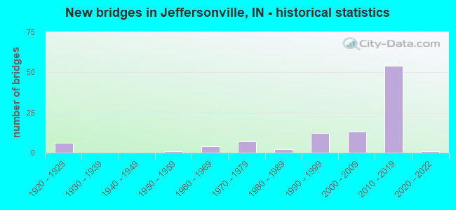
- New bridges - historical statistics
- 61920-1929
- 11950-1959
- 41960-1969
- 71970-1979
- 21980-1989
- 121990-1999
- 132000-2009
- 542010-2019
- 12020-2022
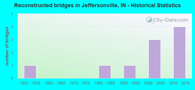
- Reconstructed bridges - Historical Statistics
- 11950-1959
- 01960-1969
- 01970-1979
- 11980-1989
- 11990-1999
- 32000-2009
- 42010-2019
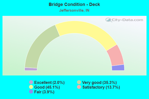
- Bridge Condition - Deck
- 2.0%Excellent
- 35.3%Very good
- 45.1%Good
- 13.7%Satisfactory
- 3.9%Fair
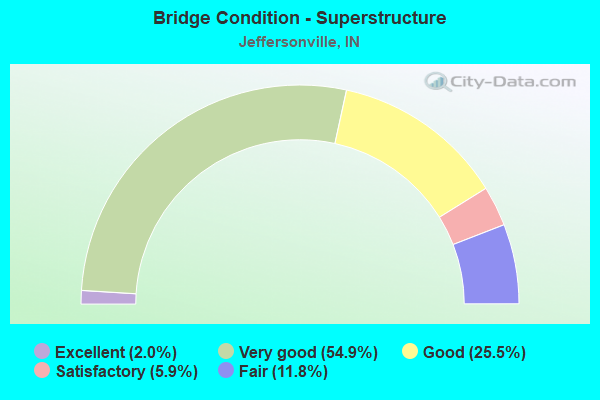
- Bridge Condition - Superstructure
- 2.0%Excellent
- 54.9%Very good
- 25.5%Good
- 5.9%Satisfactory
- 11.8%Fair
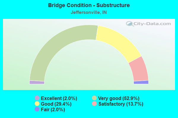
- Bridge Condition - Substructure
- 2.0%Excellent
- 52.9%Very good
- 29.4%Good
- 13.7%Satisfactory
- 2.0%Fair
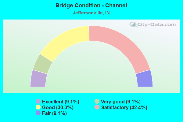
- Bridge Condition - Channel
- 9.1%Excellent
- 9.1%Very good
- 30.3%Good
- 42.4%Satisfactory
- 9.1%Fair
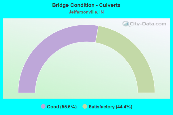
- Bridge Condition - Culverts
- 55.6%Good
- 44.4%Satisfactory
Find on map >> Show street view
Structure Number: 706, Location: 02.08 E US 27 (Lat: 40.432800, Lng: -84.938469), Route carried "on" structure: State highway 26, Year Built: 1999, Status: Open, Structure Length: 4.20m (13.78ft), Average Daily Traffic: 2,233 (year 2017), Truck Traffic: 24%, Average Future Daily Traffic: 4,223 (year 2029), Design Load: HS 20, Features Intersected: SALAMONIE RIVER
Minimum Vertical Clearance: 30+ m (98+ ft), Kilometerpoint: 25.106, Lanes on structure: 2, Owner: State Highway Agency, Approaching Roadway Width: 8.5m (27.9ft), Skew: 4 degrees, Material/Design: Prestressed concrete continuous, Design/Construction: Slab, Number Of Spans In Main Unit: 3, Length of Maximum Span: 15.3m (50.2ft), Curb-To-Curb Width: 11.8m (38.7ft), Out-to-Out Width: 12.7m (41.7ft)
Condition: Deck: Very good, Superstructure: Very good, Substructure: Very good, Channel: Satisfactory, Operating Rating: 67.0 metric tons, Method Used To Determine Operating Rating: Load and Resistance Factor (LRFR), Inventory Rating: 38.2 metric tons, Method Used To Determine Inventory Rating: Load and Resistance Factor (LRFR), Structural Evaluation: Equal to present desirable criteria, Deck Geometry: Somewhat better than minimum adequacy, Waterway Adequacy: Equal to present desirable criteria, Approach Roadway Alignment: Equal to present desirable criteria, Designated Inspection Frequency: Every 24 months, Inspection Date: October 2020, Deck Structure Type: Concrete Cast-file-Place, Wearing Surface/Protective System: Wearing Surface: Monolithic Concrete, Deck Protection: Epoxy Coated Reinforcing
Find on map >> Show street view
Structure Number: 8868, Location: 00.62 S SR 62X (Lat: 38.263611, Lng: -85.751669), Route carried "on" structure: US 31, Year Built: 1929, Year Reconstructed: 1958, Status: Posted for load, Structure Length: 150.14m (492.59ft), Average Daily Traffic: 15,200 (year 2004), Truck Traffic: 5%, Average Future Daily Traffic: 20,100 (year 2030), Design Load: H 15, Features Intersected: OHIO RIV., I-64, STREETS
Minimum Vertical Clearance: 6.48m (21.26ft), Kilometerpoint: 0.225, Lanes on structure: 4, Lanes under structure: 13, Base Highway Network: Yes (, Subroute: 1), Owner: State Highway Agency, Approaching Roadway Width: 11.6m (38.1ft), Navigation Control: Yes ( Vertical Clearance: 21.5m (70.5ft), Horizontal Clearance: 24.6m (80.7ft)), Material/Design: Steel continuous, Design/Construction: Truss - Thru, Number Of Spans In Main Unit: 7, Number Of Approach Spans: 21, Length of Maximum Span: 249.9m (819.9ft), Curb or Sidewalk Widths: Left: 2.6m (8.5ft), Right: 2.6m (8.5ft), Curb-To-Curb Width: 11.6m (38.1ft), Out-to-Out Width: 12.3m (40.4ft)
Condition: Deck: Satisfactory, Superstructure: Fair, Substructure: Fair, Channel: Good, Operating Rating: 42.3 metric tons, Method Used To Determine Operating Rating: Load Factor (LF), Inventory Rating: 25.4 metric tons, Method Used To Determine Inventory Rating: Load Factor (LF), Structural Evaluation: Somewhat better than minimum adequacy, Deck Geometry: High priority of replacement, Underclear: High priority of corrective action, Waterway Adequacy: Equal to present desirable criteria, Approach Roadway Alignment: Equal to present desirable criteria, Designated Inspection Frequency: Every 24 months, Critical Feature Inspection Frequency: Every 24 months, Underwater Inspection Frequency: Every 60 months, Inspection Date: May 2020, Critical Feature Inspection Date: May 2020, Underwater Inspection Date: August 2018, Deck Structure Type: Concrete Cast-file-Place, Wearing Surface/Protective System: Wearing Surface: Monolithic Concrete, Deck Protection: Epoxy Coated Reinforcing
Find on map >> Show street view
Structure Number: 8891, Location: 00.08 S SR 62X (Lat: 38.278131, Lng: -85.748769), Route carried "on" structure: Ramp US 31, Year Built: 2015, Status: Open, Structure Length: 2.55m (8.37ft), Average Daily Traffic: 10,500 (year 2010), Truck Traffic: 5%, Average Future Daily Traffic: 10,700 (year 2030), Design Load: HL 93, Features Intersected: 2 RR, 9TH STREET
Minimum Vertical Clearance: 30+ m (98+ ft), Kilometerpoint: 1.094, Lanes on structure: 1, Lanes under structure: 2, Base Highway Network: Yes (, Subroute: 1), Owner: State Highway Agency, Approaching Roadway Width: 9.8m (32.2ft), Material/Design: Prestressed concrete, Design/Construction: Tee Beam, Number Of Spans In Main Unit: 1, Length of Maximum Span: 24.8m (81.4ft), Curb-To-Curb Width: 9.8m (32.2ft), Out-to-Out Width: 10.7m (35.1ft)
Condition: Deck: Very good, Superstructure: Very good, Substructure: Very good, Operating Rating: 62.2 metric tons, Method Used To Determine Operating Rating: Load and Resistance Factor Rating (LRFR) rating reported by rating factor(RF) method using HL-93 loadings, Inventory Rating: 39.5 metric tons, Method Used To Determine Inventory Rating: Load and Resistance Factor Rating (LRFR) rating reported by rating factor(RF) method using HL-93 loadings, Structural Evaluation: Equal to present desirable criteria, Deck Geometry: Superior to present desirable criteria, Underclear: Better than present minimum criteria, Approach Roadway Alignment: Equal to present desirable criteria, Designated Inspection Frequency: Every 24 months, Inspection Date: December 2021, Deck Structure Type: Concrete Cast-file-Place, Wearing Surface/Protective System: Wearing Surface: Monolithic Concrete, Deck Protection: Epoxy Coated Reinforcing
Find on map >> Show street view
Structure Number: 8901, Location: 00.08 S SR 62X (Lat: 38.278150, Lng: -85.749939), Route carried "on" structure: US 31, Year Built: 2016, Status: Open, Structure Length: 4.75m (15.58ft), Average Daily Traffic: 17,200 (year 2010), Truck Traffic: 1%, Average Future Daily Traffic: 17,200 (year 2030), Design Load: HL 93, Features Intersected: 2 RR, 9TH STREET
Minimum Vertical Clearance: 30+ m (98+ ft), Kilometerpoint: 1.094, Lanes on structure: 3, Lanes under structure: 2, Base Highway Network: Yes (, Subroute: 1), Owner: State Highway Agency, Approaching Roadway Width: 15.9m (52.2ft), Material/Design: Concrete, Design/Construction: Tee Beam, Number Of Spans In Main Unit: 1, Length of Maximum Span: 46.8m (153.5ft), Curb-To-Curb Width: 16.4m (53.8ft), Out-to-Out Width: 17.3m (56.8ft)
Condition: Deck: Good, Superstructure: Very good, Substructure: Very good, Operating Rating: 74.8 metric tons, Method Used To Determine Operating Rating: Load and Resistance Factor Rating (LRFR) rating reported by rating factor(RF) method using HL-93 loadings, Inventory Rating: 58.0 metric tons, Method Used To Determine Inventory Rating: Load and Resistance Factor Rating (LRFR) rating reported by rating factor(RF) method using HL-93 loadings, Structural Evaluation: Equal to present desirable criteria, Deck Geometry: Equal to present minimum criteria, Underclear: Superior to present desirable criteria, Approach Roadway Alignment: Equal to present desirable criteria, Designated Inspection Frequency: Every 24 months, Inspection Date: December 2021, Deck Structure Type: Concrete Cast-file-Place, Wearing Surface/Protective System: Wearing Surface: Monolithic Concrete, Deck Protection: Epoxy Coated Reinforcing
Find on map >> Show street view
Structure Number: 34528, Location: 00.44 S US 31 (Lat: 38.264719, Lng: -85.743611), Route carried "on" structure: Interstate 65, Year Built: 1964, Year Reconstructed: 2016, Status: Open, Structure Length: 76.15m (249.84ft), Average Daily Traffic: 60,500 (year 2008), Truck Traffic: 12%, Average Future Daily Traffic: 341,301 (year 2030), Design Load: HS 20, Features Intersected: OHIO RIVER
Minimum Vertical Clearance: 5.44m (17.85ft), Kilometerpoint: 0.000, Lanes on structure: 6, Base Highway Network: Yes (, Subroute: 1), Owner: State Highway Agency, Maintenance Responsibility: State Toll Authority, Approaching Roadway Width: 27.8m (91.2ft), Navigation Control: Yes ( Vertical Clearance: 21.3m (69.9ft), Horizontal Clearance: 213.4m (700.1ft)), Material/Design: Steel, Design/Construction: Truss - Thru, Number Of Spans In Main Unit: 5, Length of Maximum Span: 213.4m (700.1ft), Curb-To-Curb Width: 27.8m (91.2ft), Out-to-Out Width: 28.6m (93.8ft)
Condition: Deck: Good, Superstructure: Fair, Substructure: Satisfactory, Channel: Good, Operating Rating: 29.8 metric tons, Method Used To Determine Operating Rating: Load and Resistance Factor Rating (LRFR) rating reported by rating factor(RF) method using HL-93 loadings, Inventory Rating: 23.0 metric tons, Method Used To Determine Inventory Rating: Load and Resistance Factor Rating (LRFR) rating reported by rating factor(RF) method using HL-93 loadings, Structural Evaluation: Somewhat better than minimum adequacy, Deck Geometry: Equal to present minimum criteria, Waterway Adequacy: Superior to present desirable criteria, Approach Roadway Alignment: Equal to present minimum criteria, Bridge Posting: Required (Relationship of Operating Rating to Maximum Legal Load: 0.1 - 9.9% below), Designated Inspection Frequency: Every 24 months, Critical Feature Inspection Frequency: Every 24 months, Underwater Inspection Frequency: Every 60 months, Inspection Date: August 2020, Critical Feature Inspection Date: August 2020, Underwater Inspection Date: November 2018, Deck Structure Type: Concrete Cast-file-Place, Wearing Surface/Protective System: Deck Protection: Epoxy Coated Reinforcing
Find on map >> Show street view
Structure Number: 34541, Location: 00.10 S 5TH ST (Lat: 38.272100, Lng: -85.747000), Route carried "on" structure: Interstate 65, Year Built: 2015, Status: Open, Structure Length: 3.04m (9.97ft), Average Daily Traffic: 85,668 (year 2004), Truck Traffic: 20%, Average Future Daily Traffic: 104,000 (year 2030), Design Load: HL 93, Features Intersected: COURT AVENUE
Minimum Vertical Clearance: 30+ m (98+ ft), Kilometerpoint: 0.515, Lanes on structure: 5, Lanes under structure: 5, Base Highway Network: Yes (, Subroute: 1), Owner: State Highway Agency, Approaching Roadway Width: 27.3m (89.6ft), Material/Design: Prestressed concrete, Design/Construction: Tee Beam, Number Of Spans In Main Unit: 1, Length of Maximum Span: 29.9m (98.1ft), Curb-To-Curb Width: 27.4m (89.9ft), Out-to-Out Width: 28.3m (92.8ft)
Condition: Deck: Good, Superstructure: Very good, Substructure: Good, Operating Rating: 54.8 metric tons, Method Used To Determine Operating Rating: Load and Resistance Factor Rating (LRFR) rating reported by rating factor(RF) method using HL-93 loadings, Inventory Rating: 29.2 metric tons, Method Used To Determine Inventory Rating: Load and Resistance Factor Rating (LRFR) rating reported by rating factor(RF) method using HL-93 loadings, Structural Evaluation: Better than present minimum criteria, Deck Geometry: Superior to present desirable criteria, Underclear: Somewhat better than minimum adequacy, Approach Roadway Alignment: Equal to present desirable criteria, Designated Inspection Frequency: Every 24 months, Inspection Date: December 2021, Deck Structure Type: Concrete Cast-file-Place, Wearing Surface/Protective System: Wearing Surface: Monolithic Concrete, Deck Protection: Epoxy Coated Reinforcing
Find on map >> Show street view
Structure Number: 34561, Location: 05.27 S I-265 (Lat: 38.274289, Lng: -85.748431), Route carried "on" structure: Interstate 65, Year Built: 2016, Status: Open, Structure Length: 3.11m (10.20ft), Average Daily Traffic: 111,900 (year 2010), Truck Traffic: 19%, Average Future Daily Traffic: 111,900 (year 2030), Design Load: HL 93, Features Intersected: 6TH STREET
Minimum Vertical Clearance: 30+ m (98+ ft), Kilometerpoint: 0.853, Lanes on structure: 4, Lanes under structure: 3, Base Highway Network: Yes (, Subroute: 1), Owner: State Highway Agency, Approaching Roadway Width: 25.6m (84.0ft), Skew: 2 degrees, Material/Design: Prestressed concrete, Design/Construction: Tee Beam, Number Of Spans In Main Unit: 1, Length of Maximum Span: 30.1m (98.8ft), Curb-To-Curb Width: 25.6m (84.0ft), Out-to-Out Width: 26.4m (86.6ft)
Condition: Deck: Very good, Superstructure: Very good, Substructure: Good, Operating Rating: 59.3 metric tons, Method Used To Determine Operating Rating: Load and Resistance Factor Rating (LRFR) rating reported by rating factor(RF) method using HL-93 loadings, Inventory Rating: 44.1 metric tons, Method Used To Determine Inventory Rating: Load and Resistance Factor Rating (LRFR) rating reported by rating factor(RF) method using HL-93 loadings, Structural Evaluation: Better than present minimum criteria, Deck Geometry: Superior to present desirable criteria, Underclear: Better than present minimum criteria, Approach Roadway Alignment: Equal to present desirable criteria, Designated Inspection Frequency: Every 24 months, Inspection Date: December 2021, Deck Structure Type: Concrete Cast-file-Place, Wearing Surface/Protective System: Wearing Surface: Monolithic Concrete, Deck Protection: Epoxy Coated Reinforcing
Find on map >> Show street view
Structure Number: 34591, Location: 00.34 N US 31 (Lat: 38.279419, Lng: -85.749739), Route carried "on" structure: Interstate 65, Year Built: 2015, Status: Open, Structure Length: 2.61m (8.56ft), Average Daily Traffic: 88,299 (year 2004), Truck Traffic: 20%, Average Future Daily Traffic: 94,300 (year 2030), Design Load: HL 93, Features Intersected: 10TH STREET
Minimum Vertical Clearance: 30+ m (98+ ft), Kilometerpoint: 1.400, Lanes on structure: 7, Lanes under structure: 2, Base Highway Network: Yes (, Subroute: 1), Owner: State Highway Agency, Approaching Roadway Width: 50.5m (165.7ft), Skew: 2 degrees, Material/Design: Prestressed concrete, Design/Construction: Tee Beam, Number Of Spans In Main Unit: 1, Length of Maximum Span: 25.2m (82.7ft), Curb-To-Curb Width: 46.7m (153.2ft), Out-to-Out Width: 47.5m (155.8ft)
Condition: Deck: Very good, Superstructure: Very good, Substructure: Very good, Operating Rating: 67.1 metric tons, Method Used To Determine Operating Rating: Load and Resistance Factor Rating (LRFR) rating reported by rating factor(RF) method using HL-93 loadings, Inventory Rating: 38.6 metric tons, Method Used To Determine Inventory Rating: Load and Resistance Factor Rating (LRFR) rating reported by rating factor(RF) method using HL-93 loadings, Structural Evaluation: Equal to present desirable criteria, Deck Geometry: Superior to present desirable criteria, Underclear: Somewhat better than minimum adequacy, Approach Roadway Alignment: Equal to present desirable criteria, Designated Inspection Frequency: Every 24 months, Inspection Date: December 2021, Deck Structure Type: Concrete Cast-file-Place, Wearing Surface/Protective System: Wearing Surface: Monolithic Concrete, Deck Protection: Epoxy Coated Reinforcing
Find on map >> Show street view
Structure Number: 34706, Location: 00.51 N US 31 SBL (Lat: 38.326531, Lng: -85.754661), Route carried "on" structure: Ramp Interstate 65, Year Built: 2003, Status: Open, Structure Length: 3.35m (10.99ft), Average Daily Traffic: 5,100 (year 2004), Truck Traffic: 5%, Average Future Daily Traffic: 10,211 (year 2031), Design Load: HS 20, Features Intersected: I-65 SB EXIT LANE
Minimum Vertical Clearance: 30+ m (98+ ft), Kilometerpoint: 6.968, Lanes on structure: 2, Lanes under structure: 1, Base Highway Network: Yes (, Subroute: 1), Owner: State Highway Agency, Approaching Roadway Width: 12.5m (41.0ft), Skew: 6 degrees, Material/Design: Steel, Design/Construction: Stringer/Multi-beam, Number Of Spans In Main Unit: 1, Length of Maximum Span: 31.3m (102.7ft), Curb-To-Curb Width: 12.6m (41.3ft), Out-to-Out Width: 13.5m (44.3ft)
Condition: Deck: Good, Superstructure: Very good, Substructure: Very good, Operating Rating: 80.4 metric tons, Method Used To Determine Operating Rating: Load and Resistance Factor Rating (LRFR) rating reported by rating factor(RF) method using HL-93 loadings, Inventory Rating: 61.9 metric tons, Method Used To Determine Inventory Rating: Load and Resistance Factor Rating (LRFR) rating reported by rating factor(RF) method using HL-93 loadings, Structural Evaluation: Equal to present desirable criteria, Deck Geometry: Superior to present desirable criteria, Underclear: Somewhat better than minimum adequacy, Approach Roadway Alignment: Equal to present desirable criteria, Designated Inspection Frequency: Every 24 months, Inspection Date: August 2021, Deck Structure Type: Concrete Cast-file-Place, Wearing Surface/Protective System: Wearing Surface: Monolithic Concrete, Deck Protection: Epoxy Coated Reinforcing
Find on map >> Show street view
Structure Number: 34708, Location: 00.72 S I-265 (Lat: 38.329489, Lng: -85.754189), Route carried "on" structure: City street , Year Built: 2003, Status: Open, Structure Length: 5.61m (18.41ft), Average Daily Traffic: 16,512 (year 2004), Truck Traffic: 12%, Average Future Daily Traffic: 27,496 (year 2031), Design Load: HS 20, Features Intersected: I-65, Facility Carried by Structure: VETERANS PARKWAY
Minimum Vertical Clearance: 30+ m (98+ ft), Kilometerpoint: 0.000, Lanes on structure: 6, Lanes under structure: 10, Owner: State Highway Agency, Approaching Roadway Width: 23.2m (76.1ft), Skew: 20 degrees, Material/Design: Prestressed concrete continuous, Design/Construction: Tee Beam, Number Of Spans In Main Unit: 2, Length of Maximum Span: 27.7m (90.9ft), Curb or Sidewalk Widths: Left: 1.8m (5.9ft), Right: 1.8m (5.9ft), Curb-To-Curb Width: 23.2m (76.1ft), Out-to-Out Width: 29.0m (95.1ft)
Condition: Deck: Good, Superstructure: Very good, Substructure: Very good, Operating Rating: 52.8 metric tons, Method Used To Determine Operating Rating: Load and Resistance Factor Rating (LRFR) rating reported by rating factor(RF) method using HL-93 loadings, Inventory Rating: 40.8 metric tons, Method Used To Determine Inventory Rating: Load and Resistance Factor Rating (LRFR) rating reported by rating factor(RF) method using HL-93 loadings, Structural Evaluation: Equal to present desirable criteria, Deck Geometry: Meets minimum limits, Underclear: Somewhat better than minimum adequacy, Approach Roadway Alignment: Equal to present desirable criteria, Designated Inspection Frequency: Every 24 months, Inspection Date: August 2021, Deck Structure Type: Concrete Cast-file-Place, Wearing Surface/Protective System: Wearing Surface: Monolithic Concrete, Deck Protection: Epoxy Coated Reinforcing
Find on map >> Show street view
Structure Number: 3471, Location: 00.44 S I-265 (Lat: 38.335931, Lng: -85.753731), Route carried "on" structure: Alternate City street , Year Built: 1999, Status: Open, Structure Length: 6.77m (22.21ft), Average Daily Traffic: 7,376 (year 2004), Truck Traffic: 18%, Average Future Daily Traffic: 10,988 (year 2033), Design Load: HS 20, Features Intersected: I-65, Facility Carried by Structure: PROGRESS WAY
Minimum Vertical Clearance: 30+ m (98+ ft), Kilometerpoint: 0.000, Lanes on structure: 2, Lanes under structure: 9, Owner: State Highway Agency, Approaching Roadway Width: 8.2m (26.9ft), Skew: 1 degrees, Material/Design: Prestressed concrete continuous, Design/Construction: Tee Beam, Number Of Spans In Main Unit: 2, Length of Maximum Span: 35.4m (116.1ft), Curb or Sidewalk Widths: Left: 2.0m (6.6ft), Right: 2.0m (6.6ft), Curb-To-Curb Width: 8.4m (27.6ft), Out-to-Out Width: 13.3m (43.6ft)
Condition: Deck: Good, Superstructure: Good, Substructure: Very good, Operating Rating: 54.4 metric tons, Method Used To Determine Operating Rating: Load and Resistance Factor Rating (LRFR) rating reported by rating factor(RF) method using HL-93 loadings, Inventory Rating: 20.4 metric tons, Method Used To Determine Inventory Rating: Load and Resistance Factor Rating (LRFR) rating reported by rating factor(RF) method using HL-93 loadings, Structural Evaluation: Somewhat better than minimum adequacy, Deck Geometry: High priority of corrective action, Underclear: High priority of corrective action, Approach Roadway Alignment: Equal to present desirable criteria, Designated Inspection Frequency: Every 24 months, Inspection Date: August 2021, Deck Structure Type: Concrete Cast-file-Place, Wearing Surface/Protective System: Wearing Surface: Monolithic Concrete, Deck Protection: Epoxy Coated Reinforcing
Find on map >> Show street view
Structure Number: 3472, Location: 00.47 N I-265 (Lat: 38.351300, Lng: -85.754561), Route carried "on" structure: Interstate 65, Year Built: 2003, Status: Open, Structure Length: 9.24m (30.31ft), Average Daily Traffic: 35,569 (year 2004), Truck Traffic: 15%, Average Future Daily Traffic: 74,468 (year 2031), Design Load: HS 20, Features Intersected: SILVER CREEK
Minimum Vertical Clearance: 30+ m (98+ ft), Kilometerpoint: 9.785, Lanes on structure: 5, Base Highway Network: Yes (, Subroute: 1), Owner: State Highway Agency, Approaching Roadway Width: 25.3m (83.0ft), Skew: 3 degrees, Material/Design: Prestressed concrete continuous, Design/Construction: Tee Beam, Number Of Spans In Main Unit: 3, Length of Maximum Span: 34.0m (111.5ft), Curb-To-Curb Width: 25.4m (83.3ft), Out-to-Out Width: 26.2m (86.0ft)
Condition: Deck: Very good, Superstructure: Good, Substructure: Very good, Channel: Very good, Operating Rating: 52.8 metric tons, Method Used To Determine Operating Rating: Load and Resistance Factor Rating (LRFR) rating reported by rating factor(RF) method using HL-93 loadings, Inventory Rating: 38.2 metric tons, Method Used To Determine Inventory Rating: Load and Resistance Factor Rating (LRFR) rating reported by rating factor(RF) method using HL-93 loadings, Structural Evaluation: Better than present minimum criteria, Deck Geometry: Better than present minimum criteria, Waterway Adequacy: Equal to present desirable criteria, Approach Roadway Alignment: Equal to present desirable criteria, Designated Inspection Frequency: Every 24 months, Inspection Date: August 2021, Deck Structure Type: Concrete Cast-file-Place, Wearing Surface/Protective System: Wearing Surface: Monolithic Concrete, Deck Protection: Epoxy Coated Reinforcing
Find on map >> Show street view
Structure Number: 3473, Location: 00.47 N I-265 (Lat: 38.351519, Lng: -85.754261), Route carried "on" structure: Interstate 65, Year Built: 2003, Status: Open, Structure Length: 9.24m (30.31ft), Average Daily Traffic: 35,569 (year 2004), Truck Traffic: 15%, Average Future Daily Traffic: 74,468 (year 2031), Design Load: HS 20, Features Intersected: SILVER CREEK
Minimum Vertical Clearance: 30+ m (98+ ft), Kilometerpoint: 9.785, Lanes on structure: 4, Base Highway Network: Yes (, Subroute: 1), Owner: State Highway Agency, Approaching Roadway Width: 25.9m (85.0ft), Skew: 3 degrees, Material/Design: Prestressed concrete continuous, Design/Construction: Tee Beam, Number Of Spans In Main Unit: 3, Length of Maximum Span: 34.0m (111.5ft), Curb-To-Curb Width: 26.2m (86.0ft), Out-to-Out Width: 27.0m (88.6ft)
Condition: Deck: Very good, Superstructure: Good, Substructure: Very good, Channel: Very good, Operating Rating: 53.1 metric tons, Method Used To Determine Operating Rating: Load and Resistance Factor Rating (LRFR) rating reported by rating factor(RF) method using HL-93 loadings, Inventory Rating: 36.6 metric tons, Method Used To Determine Inventory Rating: Load and Resistance Factor Rating (LRFR) rating reported by rating factor(RF) method using HL-93 loadings, Structural Evaluation: Better than present minimum criteria, Deck Geometry: Superior to present desirable criteria, Waterway Adequacy: Equal to present desirable criteria, Approach Roadway Alignment: Equal to present desirable criteria, Designated Inspection Frequency: Every 24 months, Inspection Date: August 2021, Deck Structure Type: Concrete Cast-file-Place, Wearing Surface/Protective System: Wearing Surface: Monolithic Concrete, Deck Protection: Epoxy Coated Reinforcing
Find on map >> Show street view
Structure Number: 51425, Location: 00.10 W CT AVE/BROADWAY J (Lat: 38.272081, Lng: -85.749739), Route carried "on" structure: US 31, Year Built: 2016, Status: Open, Structure Length: 2.93m (9.61ft), Average Daily Traffic: 15,200 (year 2004), Truck Traffic: 2%, Average Future Daily Traffic: 35,000 (year 2030), Design Load: HL 93, Features Intersected: COURT AVENUE
Minimum Vertical Clearance: 30+ m (98+ ft), Kilometerpoint: 0.515, Lanes on structure: 2, Lanes under structure: 5, Owner: State Highway Agency, Approaching Roadway Width: 11.0m (36.1ft), Material/Design: Prestressed concrete, Design/Construction: Tee Beam, Number Of Spans In Main Unit: 1, Length of Maximum Span: 28.8m (94.5ft), Curb-To-Curb Width: 11.0m (36.1ft), Out-to-Out Width: 11.9m (39.0ft)
Condition: Deck: Very good, Superstructure: Very good, Substructure: Good, Operating Rating: 57.7 metric tons, Method Used To Determine Operating Rating: Load and Resistance Factor Rating (LRFR) rating reported by rating factor(RF) method using HL-93 loadings, Inventory Rating: 31.8 metric tons, Method Used To Determine Inventory Rating: Load and Resistance Factor Rating (LRFR) rating reported by rating factor(RF) method using HL-93 loadings, Structural Evaluation: Better than present minimum criteria, Deck Geometry: Meets minimum limits, Underclear: Somewhat better than minimum adequacy, Approach Roadway Alignment: Equal to present desirable criteria, Designated Inspection Frequency: Every 24 months, Inspection Date: December 2021, Deck Structure Type: Concrete Cast-file-Place, Wearing Surface/Protective System: Wearing Surface: Monolithic Concrete, Deck Protection: Epoxy Coated Reinforcing
Find on map >> Show street view
Structure Number: 5143, Location: 00.08 S SR 62X (Lat: 38.277839, Lng: -85.749211), Route carried "on" structure: Ramp Interstate 65, Year Built: 2016, Status: Open, Structure Length: 3.22m (10.56ft), Average Daily Traffic: 25,050 (year 2015), Truck Traffic: 9%, Average Future Daily Traffic: 16,800 (year 2030), Design Load: HL 93, Features Intersected: 9TH ST, L&I RR
Minimum Vertical Clearance: 30+ m (98+ ft), Kilometerpoint: 1.239, Lanes on structure: 3, Lanes under structure: 2, Base Highway Network: Yes (, Subroute: 1), Owner: State Highway Agency, Approaching Roadway Width: 22.2m (72.8ft), Skew: 30 degrees, Material/Design: Prestressed concrete, Design/Construction: Tee Beam, Number Of Spans In Main Unit: 1, Length of Maximum Span: 31.5m (103.3ft), Curb-To-Curb Width: 22.7m (74.5ft), Out-to-Out Width: 24.4m (80.1ft)
Condition: Deck: Good, Superstructure: Very good, Substructure: Very good, Operating Rating: 49.2 metric tons, Method Used To Determine Operating Rating: Load and Resistance Factor Rating (LRFR) rating reported by rating factor(RF) method using HL-93 loadings, Inventory Rating: 28.2 metric tons, Method Used To Determine Inventory Rating: Load and Resistance Factor Rating (LRFR) rating reported by rating factor(RF) method using HL-93 loadings, Structural Evaluation: Better than present minimum criteria, Deck Geometry: Superior to present desirable criteria, Underclear: Better than present minimum criteria, Approach Roadway Alignment: Equal to present desirable criteria, Designated Inspection Frequency: Every 24 months, Inspection Date: December 2021, Deck Structure Type: Concrete Cast-file-Place, Wearing Surface/Protective System: Wearing Surface: Monolithic Concrete, Deck Protection: Epoxy Coated Reinforcing
Find on map >> Show street view
Structure Number: 51435, Location: 00.34 S SR 62X (Lat: 38.275050, Lng: -85.748850), Route carried "on" structure: Ramp US 31, Year Built: 2016, Status: Open, Structure Length: 17.94m (58.86ft), Average Daily Traffic: 10,671 (year 2015), Truck Traffic: 2%, Average Future Daily Traffic: 11,500 (year 2030), Design Load: HL 93, Features Intersected: I-65 SB/NB, RAMPS, ST
Minimum Vertical Clearance: 30+ m (98+ ft), Kilometerpoint: 0.821, Lanes on structure: 1, Lanes under structure: 13, Owner: State Highway Agency, Approaching Roadway Width: 9.8m (32.2ft), Skew: 5 degrees, Material/Design: Prestressed concrete continuous, Design/Construction: Tee Beam, Number Of Spans In Main Unit: 4, Length of Maximum Span: 50.7m (166.3ft), Curb-To-Curb Width: 9.8m (32.2ft), Out-to-Out Width: 10.7m (35.1ft)
Condition: Deck: Good, Superstructure: Very good, Substructure: Very good, Operating Rating: 50.5 metric tons, Method Used To Determine Operating Rating: Load and Resistance Factor Rating (LRFR) rating reported by rating factor(RF) method using HL-93 loadings, Inventory Rating: 32.7 metric tons, Method Used To Determine Inventory Rating: Load and Resistance Factor Rating (LRFR) rating reported by rating factor(RF) method using HL-93 loadings, Structural Evaluation: Equal to present desirable criteria, Deck Geometry: Superior to present desirable criteria, Underclear: Meets minimum limits, Approach Roadway Alignment: Equal to present desirable criteria, Designated Inspection Frequency: Every 24 months, Inspection Date: December 2021, Deck Structure Type: Concrete Cast-file-Place, Wearing Surface/Protective System: Wearing Surface: Monolithic Concrete, Deck Protection: Epoxy Coated Reinforcing
Find on map >> Show street view
Structure Number: 51455, Location: 05.27 S I-265 (Lat: 38.274331, Lng: -85.749350), Route carried "on" structure: Ramp US 31, Year Built: 2016, Status: Open, Structure Length: 2.67m (8.76ft), Average Daily Traffic: 15,600 (year 2010), Truck Traffic: 1%, Average Future Daily Traffic: 15,600 (year 2030), Design Load: HL 93, Features Intersected: 6TH STREET
Minimum Vertical Clearance: 30+ m (98+ ft), Kilometerpoint: 0.628, Lanes on structure: 1, Lanes under structure: 3, Owner: State Highway Agency, Approaching Roadway Width: 10.4m (34.1ft), Material/Design: Prestressed concrete, Design/Construction: Tee Beam, Number Of Spans In Main Unit: 1, Length of Maximum Span: 26.2m (86.0ft), Curb-To-Curb Width: 10.4m (34.1ft), Out-to-Out Width: 11.3m (37.1ft)
Condition: Deck: Very good, Superstructure: Very good, Substructure: Very good, Operating Rating: 54.8 metric tons, Method Used To Determine Operating Rating: Load and Resistance Factor Rating (LRFR) rating reported by rating factor(RF) method using HL-93 loadings, Inventory Rating: 32.4 metric tons, Method Used To Determine Inventory Rating: Load and Resistance Factor Rating (LRFR) rating reported by rating factor(RF) method using HL-93 loadings, Structural Evaluation: Equal to present desirable criteria, Deck Geometry: Superior to present desirable criteria, Underclear: Equal to present minimum criteria, Approach Roadway Alignment: Equal to present desirable criteria, Designated Inspection Frequency: Every 24 months, Inspection Date: December 2021, Deck Structure Type: Concrete Cast-file-Place, Wearing Surface/Protective System: Wearing Surface: Monolithic Concrete, Deck Protection: Epoxy Coated Reinforcing
Find on map >> Show street view
Structure Number: 51475, Location: 05.27 S I-265 (Lat: 38.271981, Lng: -85.747350), Route carried "on" structure: Ramp Interstate 65, Year Built: 2016, Status: Open, Structure Length: 3.11m (10.20ft), Average Daily Traffic: 113,400 (year 2010), Truck Traffic: 19%, Average Future Daily Traffic: 113,400 (year 2030), Design Load: HL 93, Features Intersected: COURT AVENUE
Minimum Vertical Clearance: 30+ m (98+ ft), Kilometerpoint: 0.628, Lanes on structure: 7, Lanes under structure: 4, Base Highway Network: Yes (, Subroute: 1), Owner: State Highway Agency, Approaching Roadway Width: 38.4m (126.0ft), Skew: 32 degrees, Material/Design: Prestressed concrete, Design/Construction: Tee Beam, Number Of Spans In Main Unit: 1, Length of Maximum Span: 30.3m (99.4ft), Curb-To-Curb Width: 38.4m (126.0ft), Out-to-Out Width: 40.0m (131.2ft)
Condition: Deck: Good, Superstructure: Very good, Substructure: Good, Operating Rating: 61.6 metric tons, Method Used To Determine Operating Rating: Load and Resistance Factor Rating (LRFR) rating reported by rating factor(RF) method using HL-93 loadings, Inventory Rating: 37.9 metric tons, Method Used To Determine Inventory Rating: Load and Resistance Factor Rating (LRFR) rating reported by rating factor(RF) method using HL-93 loadings, Structural Evaluation: Better than present minimum criteria, Deck Geometry: Superior to present desirable criteria, Underclear: Equal to present minimum criteria, Approach Roadway Alignment: Equal to present desirable criteria, Designated Inspection Frequency: Every 24 months, Inspection Date: December 2021, Deck Structure Type: Concrete Cast-file-Place, Wearing Surface/Protective System: Wearing Surface: Monolithic Concrete, Deck Protection: Epoxy Coated Reinforcing
Find on map >> Show street view
Structure Number: 7059, Location: 00.20 W SR 62 (Lat: 38.343981, Lng: -85.710511), Route carried "on" structure: State highway 265, Year Built: 1992, Year Reconstructed: 2016, Status: Open, Structure Length: 6.14m (20.14ft), Average Daily Traffic: 12,700 (year 2010), Truck Traffic: 16%, Average Future Daily Traffic: 29,700 (year 2030), Design Load: HS 20+Mod, Features Intersected: C&O RR, CMC RR
Minimum Vertical Clearance: 30+ m (98+ ft), Kilometerpoint: 15.096, Lanes on structure: 3, Base Highway Network: Yes (, Subroute: 1), Owner: State Highway Agency, Maintenance Responsibility: State Toll Authority, Approaching Roadway Width: 22.4m (73.5ft), Skew: 2 degrees, Material/Design: Prestressed concrete continuous, Design/Construction: Stringer/Multi-beam, Number Of Spans In Main Unit: 4, Length of Maximum Span: 16.8m (55.1ft), Curb-To-Curb Width: 22.6m (74.1ft), Out-to-Out Width: 23.5m (77.1ft)
Condition: Deck: Good, Superstructure: Very good, Substructure: Very good, Operating Rating: 45.4 metric tons, Method Used To Determine Operating Rating: Load and Resistance Factor Rating (LRFR) rating reported by rating factor(RF) method using HL-93 loadings, Inventory Rating: 33.4 metric tons, Method Used To Determine Inventory Rating: Load and Resistance Factor Rating (LRFR) rating reported by rating factor(RF) method using HL-93 loadings, Structural Evaluation: Equal to present desirable criteria, Deck Geometry: Superior to present desirable criteria, Underclear: Equal to present minimum criteria, Approach Roadway Alignment: Equal to present desirable criteria, Designated Inspection Frequency: Every 24 months, Inspection Date: July 2020, Deck Structure Type: Concrete Cast-file-Place, Wearing Surface/Protective System: Wearing Surface: Monolithic Concrete, Deck Protection: Epoxy Coated Reinforcing
Find on map >> Show street view
Structure Number: 706, Location: 00.20 W SR 62 (Lat: 38.344319, Lng: -85.710431), Route carried "on" structure: State highway 265, Year Built: 1992, Year Reconstructed: 2016, Status: Open, Structure Length: 5.09m (16.70ft), Average Daily Traffic: 12,700 (year 2010), Truck Traffic: 16%, Average Future Daily Traffic: 29,700 (year 2030), Design Load: HS 20, Features Intersected: C&O RR, CMC RR
Minimum Vertical Clearance: 30+ m (98+ ft), Kilometerpoint: 15.096, Lanes on structure: 2, Base Highway Network: Yes (, Subroute: 1), Owner: State Highway Agency, Maintenance Responsibility: State Toll Authority, Approaching Roadway Width: 12.2m (40.0ft), Skew: 2 degrees, Material/Design: Prestressed concrete continuous, Design/Construction: Stringer/Multi-beam, Number Of Spans In Main Unit: 3, Length of Maximum Span: 17.8m (58.4ft), Curb-To-Curb Width: 13.2m (43.3ft), Out-to-Out Width: 14.1m (46.3ft)
Condition: Deck: Very good, Superstructure: Very good, Substructure: Good, Operating Rating: 42.8 metric tons, Method Used To Determine Operating Rating: Load and Resistance Factor Rating (LRFR) rating reported by rating factor(RF) method using HL-93 loadings, Inventory Rating: 29.2 metric tons, Method Used To Determine Inventory Rating: Load and Resistance Factor Rating (LRFR) rating reported by rating factor(RF) method using HL-93 loadings, Structural Evaluation: Better than present minimum criteria, Deck Geometry: Superior to present desirable criteria, Underclear: Equal to present minimum criteria, Approach Roadway Alignment: Equal to present desirable criteria, Designated Inspection Frequency: Every 24 months, Inspection Date: July 2020, Deck Structure Type: Concrete Cast-file-Place, Wearing Surface/Protective System: Wearing Surface: Monolithic Concrete, Deck Protection: Epoxy Coated Reinforcing
Find on map >> Show street view
Structure Number: 7061, Location: 00.20 W SR 62 (Lat: 38.344611, Lng: -85.710281), Route carried "on" structure: Ramp State highway 265, Year Built: 1992, Year Reconstructed: 2016, Status: Open, Structure Length: 5.47m (17.95ft), Average Daily Traffic: 10,500 (year 2010), Truck Traffic: 10%, Average Future Daily Traffic: 13,400 (year 2030), Design Load: HS 20, Features Intersected: C&O RR, CMC RR
Minimum Vertical Clearance: 30+ m (98+ ft), Kilometerpoint: 15.096, Lanes on structure: 1, Base Highway Network: Yes (, Subroute: 1), Owner: State Highway Agency, Maintenance Responsibility: State Toll Authority, Approaching Roadway Width: 11.9m (39.0ft), Skew: 3 degrees, Material/Design: Prestressed concrete continuous, Design/Construction: Stringer/Multi-beam, Number Of Spans In Main Unit: 3, Length of Maximum Span: 17.9m (58.7ft), Curb-To-Curb Width: 11.0m (36.1ft), Out-to-Out Width: 11.9m (39.0ft)
Condition: Deck: Very good, Superstructure: Very good, Substructure: Very good, Operating Rating: 42.4 metric tons, Method Used To Determine Operating Rating: Load and Resistance Factor Rating (LRFR) rating reported by rating factor(RF) method using HL-93 loadings, Inventory Rating: 32.7 metric tons, Method Used To Determine Inventory Rating: Load and Resistance Factor Rating (LRFR) rating reported by rating factor(RF) method using HL-93 loadings, Structural Evaluation: Equal to present desirable criteria, Deck Geometry: Superior to present desirable criteria, Underclear: Better than present minimum criteria, Approach Roadway Alignment: Equal to present desirable criteria, Designated Inspection Frequency: Every 24 months, Inspection Date: July 2020, Deck Structure Type: Concrete Cast-file-Place, Wearing Surface/Protective System: Wearing Surface: Monolithic Concrete, Deck Protection: Epoxy Coated Reinforcing
Find on map >> Show street view
Structure Number: 799, Location: 00.12 E SR 62 (Lat: 38.343831, Lng: -85.700150), Route carried "on" structure: City street , Year Built: 2015, Status: Open, Structure Length: 5.24m (17.19ft), Average Daily Traffic: 4,050 (year 2010), Truck Traffic: 43%, Average Future Daily Traffic: 4,100 (year 2030), Design Load: HL 93, Features Intersected: SR 265 EB/WB, Facility Carried by Structure: PORT ROAD
Minimum Vertical Clearance: 30+ m (98+ ft), Kilometerpoint: 0.000, Lanes on structure: 2, Lanes under structure: 4, Owner: State Highway Agency, Maintenance Responsibility: State Toll Authority, Approaching Roadway Width: 9.4m (30.8ft), Material/Design: Prestressed concrete continuous, Design/Construction: Stringer/Multi-beam, Number Of Spans In Main Unit: 2, Length of Maximum Span: 25.9m (85.0ft), Curb-To-Curb Width: 9.4m (30.8ft), Out-to-Out Width: 10.4m (34.1ft)
Condition: Deck: Very good, Superstructure: Very good, Substructure: Very good, Operating Rating: 65.8 metric tons, Method Used To Determine Operating Rating: Load and Resistance Factor Rating (LRFR) rating reported by rating factor(RF) method using HL-93 loadings, Inventory Rating: 36.9 metric tons, Method Used To Determine Inventory Rating: Load and Resistance Factor Rating (LRFR) rating reported by rating factor(RF) method using HL-93 loadings, Structural Evaluation: Equal to present desirable criteria, Deck Geometry: Meets minimum limits, Approach Roadway Alignment: Equal to present desirable criteria, Designated Inspection Frequency: Every 24 months, Inspection Date: July 2020, Deck Structure Type: Concrete Cast-file-Place, Wearing Surface/Protective System: Wearing Surface: Monolithic Concrete, Deck Protection: Epoxy Coated Reinforcing
Find on map >> Show street view
Structure Number: 79902, Location: 00.12 E SR 62 (Lat: 38.343261, Lng: -85.700181), Route carried "on" structure: City street , Year Built: 2015, Status: Open, Structure Length: 1.67m (5.48ft), Average Daily Traffic: 4,050 (year 2010), Truck Traffic: 43%, Average Future Daily Traffic: 4,100 (year 2030), Design Load: HL 93, Features Intersected: RAMP SR 62 TO SR 265 EB, Facility Carried by Structure: PORT ROAD
Minimum Vertical Clearance: 30+ m (98+ ft), Kilometerpoint: 15.611, Lanes on structure: 2, Lanes under structure: 1, Owner: State Highway Agency, Maintenance Responsibility: State Toll Authority, Approaching Roadway Width: 9.4m (30.8ft), Material/Design: Prestressed concrete, Design/Construction: Stringer/Multi-beam, Number Of Spans In Main Unit: 1, Length of Maximum Span: 16.1m (52.8ft), Curb-To-Curb Width: 9.4m (30.8ft), Out-to-Out Width: 10.4m (34.1ft)
Condition: Deck: Very good, Superstructure: Very good, Substructure: Very good, Operating Rating: 55.4 metric tons, Method Used To Determine Operating Rating: Load and Resistance Factor Rating (LRFR) rating reported by rating factor(RF) method using HL-93 loadings, Inventory Rating: 39.9 metric tons, Method Used To Determine Inventory Rating: Load and Resistance Factor Rating (LRFR) rating reported by rating factor(RF) method using HL-93 loadings, Structural Evaluation: Equal to present desirable criteria, Deck Geometry: Meets minimum limits, Underclear: Equal to present minimum criteria, Approach Roadway Alignment: Equal to present desirable criteria, Designated Inspection Frequency: Every 24 months, Inspection Date: July 2020, Deck Structure Type: Concrete Cast-file-Place, Wearing Surface/Protective System: Wearing Surface: Monolithic Concrete, Deck Protection: Epoxy Coated Reinforcing
Find on map >> Show street view
Structure Number: 79904, Location: 00.83 E SR 62 (Lat: 38.343639, Lng: -85.691139), Route carried "on" structure: City street , Year Built: 2015, Status: Open, Structure Length: 6.57m (21.56ft), Average Daily Traffic: 2,200 (year 2014), Truck Traffic: 7%, Average Future Daily Traffic: 5,000 (year 2030), Design Load: HL 93, Features Intersected: SR 265 EB/WB, Facility Carried by Structure: UTICA-SELLERSBURG
Minimum Vertical Clearance: 30+ m (98+ ft), Kilometerpoint: 0.000, Lanes on structure: 2, Lanes under structure: 4, Owner: State Highway Agency, Approaching Roadway Width: 12.9m (42.3ft), Skew: 3 degrees, Material/Design: Prestressed concrete continuous, Design/Construction: Stringer/Multi-beam, Number Of Spans In Main Unit: 2, Length of Maximum Span: 32.6m (107.0ft), Curb-To-Curb Width: 12.0m (39.4ft), Out-to-Out Width: 12.9m (42.3ft)
Condition: Deck: Good, Superstructure: Very good, Substructure: Very good, Operating Rating: 50.5 metric tons, Method Used To Determine Operating Rating: Load and Resistance Factor Rating (LRFR) rating reported by rating factor(RF) method using HL-93 loadings, Inventory Rating: 38.9 metric tons, Method Used To Determine Inventory Rating: Load and Resistance Factor Rating (LRFR) rating reported by rating factor(RF) method using HL-93 loadings, Structural Evaluation: Equal to present desirable criteria, Deck Geometry: Somewhat better than minimum adequacy, Underclear: Equal to present minimum criteria, Approach Roadway Alignment: Equal to present desirable criteria, Designated Inspection Frequency: Every 24 months, Inspection Date: November 2020, Deck Structure Type: Concrete Cast-file-Place, Wearing Surface/Protective System: Wearing Surface: Monolithic Concrete, Deck Protection: Epoxy Coated Reinforcing
Find on map >> Show street view
Structure Number: 79916, Location: 05.27 S I-265 (Lat: 38.274356, Lng: -85.747917), Route carried "on" structure: Ramp Interstate 65, Year Built: 2015, Status: Open, Structure Length: 3.65m (11.98ft), Average Daily Traffic: 4,500 (year 2010), Truck Traffic: 40%, Average Future Daily Traffic: 5,300 (year 2030), Design Load: HL 93, Features Intersected: 6TH STREET
Minimum Vertical Clearance: 30+ m (98+ ft), Kilometerpoint: 0.628, Lanes on structure: 2, Lanes under structure: 3, Base Highway Network: Yes (, Subroute: 1), Owner: State Highway Agency, Approaching Roadway Width: 12.8m (42.0ft), Skew: 2 degrees, Material/Design: Prestressed concrete, Design/Construction: Tee Beam, Number Of Spans In Main Unit: 1, Length of Maximum Span: 35.8m (117.5ft), Curb-To-Curb Width: 12.8m (42.0ft), Out-to-Out Width: 13.8m (45.3ft)
Condition: Deck: Very good, Superstructure: Very good, Substructure: Very good, Operating Rating: 59.6 metric tons, Method Used To Determine Operating Rating: Load and Resistance Factor Rating (LRFR) rating reported by rating factor(RF) method using HL-93 loadings, Inventory Rating: 34.3 metric tons, Method Used To Determine Inventory Rating: Load and Resistance Factor Rating (LRFR) rating reported by rating factor(RF) method using HL-93 loadings, Structural Evaluation: Equal to present desirable criteria, Deck Geometry: Superior to present desirable criteria, Underclear: Better than present minimum criteria, Approach Roadway Alignment: Equal to present desirable criteria, Designated Inspection Frequency: Every 24 months, Inspection Date: December 2021, Deck Structure Type: Concrete Cast-file-Place, Wearing Surface/Protective System: Wearing Surface: Monolithic Concrete, Deck Protection: Epoxy Coated Reinforcing
Find on map >> Show street view
Structure Number: 79918, Location: 00.08 S SR 62X (Lat: 38.278161, Lng: -85.749269), Route carried "on" structure: Interstate 65, Year Built: 2015, Status: Open, Structure Length: 3.78m (12.40ft), Average Daily Traffic: 44,149 (year 2004), Truck Traffic: 20%, Average Future Daily Traffic: 52,000 (year 2030), Design Load: HL 93, Features Intersected: 9TH ST, L&I RR
Minimum Vertical Clearance: 30+ m (98+ ft), Kilometerpoint: 1.094, Lanes on structure: 5, Lanes under structure: 2, Base Highway Network: Yes (, Subroute: 1), Owner: State Highway Agency, Approaching Roadway Width: 26.0m (85.3ft), Skew: 1 degrees, Material/Design: Prestressed concrete, Design/Construction: Tee Beam, Number Of Spans In Main Unit: 1, Length of Maximum Span: 37.1m (121.7ft), Curb-To-Curb Width: 25.6m (84.0ft), Out-to-Out Width: 26.4m (86.6ft)
Condition: Deck: Good, Superstructure: Very good, Substructure: Very good, Operating Rating: 59.6 metric tons, Method Used To Determine Operating Rating: Load and Resistance Factor Rating (LRFR) rating reported by rating factor(RF) method using HL-93 loadings, Inventory Rating: 35.3 metric tons, Method Used To Determine Inventory Rating: Load and Resistance Factor Rating (LRFR) rating reported by rating factor(RF) method using HL-93 loadings, Structural Evaluation: Equal to present desirable criteria, Deck Geometry: Better than present minimum criteria, Underclear: Better than present minimum criteria, Approach Roadway Alignment: Equal to present desirable criteria, Designated Inspection Frequency: Every 24 months, Inspection Date: December 2021, Deck Structure Type: Concrete Cast-file-Place, Wearing Surface/Protective System: Wearing Surface: Monolithic Concrete, Deck Protection: Epoxy Coated Reinforcing
Find on map >> Show street view
Structure Number: 7997, Location: 00.44 S US 31 over OHIO R (Lat: 38.264569, Lng: -85.742700), Route carried "on" structure: Interstate 65, Year Built: 2016, Status: Open, Structure Length: 64.19m (210.60ft), Average Daily Traffic: 60,500 (year 2008), Truck Traffic: 12%, Average Future Daily Traffic: 341,301 (year 2030), Design Load: Greater than HL93, Features Intersected: OHIO RIVER
Minimum Vertical Clearance: 30+ m (98+ ft), Kilometerpoint: 0.000, Lanes on structure: 6, Base Highway Network: Yes (, Subroute: 1), Toll: Toll bridge, Owner: State Highway Agency, Maintenance Responsibility: State Toll Authority, Approaching Roadway Width: 29.3m (96.1ft), Navigation Control: Yes ( Vertical Clearance: 21.6m (70.9ft), Horizontal Clearance: 228.6m (750.0ft)), Material/Design: Steel continuous, Design/Construction: Stayed Girder, Number Of Spans In Main Unit: 4, Length of Maximum Span: 228.6m (750.0ft), Curb-To-Curb Width: 29.3m (96.1ft), Out-to-Out Width: 30.8m (101.0ft)
Condition: Deck: Good, Superstructure: Good, Substructure: Good, Channel: Good, Operating Rating: 43.1 metric tons, Method Used To Determine Operating Rating: Load and Resistance Factor Rating (LRFR) rating reported by rating factor(RF) method using HL-93 loadings, Inventory Rating: 33.0 metric tons, Method Used To Determine Inventory Rating: Load and Resistance Factor Rating (LRFR) rating reported by rating factor(RF) method using HL-93 loadings, Structural Evaluation: Better than present minimum criteria, Deck Geometry: Better than present minimum criteria, Waterway Adequacy: Superior to present desirable criteria, Approach Roadway Alignment: Equal to present desirable criteria, Designated Inspection Frequency: Every 24 months, Critical Feature Inspection Frequency: Every 24 months, Underwater Inspection Frequency: Every 60 months, Other Special Inspection Frequency: Every 60 months, Inspection Date: September 2020, Critical Feature Inspection Date: September 2020, Underwater Inspection Date: November 2018, Other Special Inspection Date: June 2019, Deck Structure Type: Concrete Precast Panels, Wearing Surface/Protective System: Wearing Surface: Bituminous, Membrane: Other, Deck Protection: Epoxy Coated Reinforcing
Find on map >> Show street view
Structure Number: 79972, Location: 00.43 S US 31 (Lat: 38.268581, Lng: -85.745150), Route carried "on" structure: Interstate 65, Year Built: 2016, Status: Open, Structure Length: 32.39m (106.27ft), Average Daily Traffic: 60,500 (year 2008), Truck Traffic: 14%, Average Future Daily Traffic: 355,159 (year 2030), Design Load: Greater than HL93, Features Intersected: RIVERSIDE DR, MARKET ST
Minimum Vertical Clearance: 30+ m (98+ ft), Kilometerpoint: 0.161, Lanes on structure: 6, Lanes under structure: 4, Base Highway Network: Yes (, Subroute: 1), Toll: On toll road, Owner: State Highway Agency, Maintenance Responsibility: State Toll Authority, Approaching Roadway Width: 29.3m (96.1ft), Material/Design: Steel continuous, Design/Construction: Stringer/Multi-beam, Number Of Spans In Main Unit: 5, Length of Maximum Span: 73.2m (240.2ft), Curb-To-Curb Width: 29.3m (96.1ft), Out-to-Out Width: 30.1m (98.8ft)
Condition: Deck: Good, Superstructure: Very good, Substructure: Good, Operating Rating: 52.8 metric tons, Method Used To Determine Operating Rating: Load and Resistance Factor Rating (LRFR) rating reported by rating factor(RF) method using HL-93 loadings, Inventory Rating: 40.8 metric tons, Method Used To Determine Inventory Rating: Load and Resistance Factor Rating (LRFR) rating reported by rating factor(RF) method using HL-93 loadings, Structural Evaluation: Better than present minimum criteria, Deck Geometry: Better than present minimum criteria, Underclear: Better than present minimum criteria, Approach Roadway Alignment: Equal to present desirable criteria, Designated Inspection Frequency: Every 24 months, Inspection Date: October 2020, Deck Structure Type: Concrete Cast-file-Place, Wearing Surface/Protective System: Wearing Surface: Monolithic Concrete, Deck Protection: Epoxy Coated Reinforcing
Find on map >> Show street view
Structure Number: 80447, Location: 00.43 S US 31 (Lat: 38.268611, Lng: -85.745561), Route carried "on" structure: Interstate 65, Year Built: 2016, Status: Open, Structure Length: 20.26m (66.47ft), Average Daily Traffic: 60,500 (year 2008), Truck Traffic: 14%, Average Future Daily Traffic: 355,159 (year 2030), Design Load: Greater than HL93, Features Intersected: RIVERSIDE DR, MARKET ST
Minimum Vertical Clearance: 30+ m (98+ ft), Kilometerpoint: 0.161, Lanes on structure: 6, Lanes under structure: 4, Base Highway Network: Yes (, Subroute: 1), Toll: On toll road, Owner: State Highway Agency, Maintenance Responsibility: State Toll Authority, Approaching Roadway Width: 27.8m (91.2ft), Material/Design: Steel continuous, Design/Construction: Stringer/Multi-beam, Number Of Spans In Main Unit: 3, Length of Maximum Span: 77.7m (254.9ft), Curb-To-Curb Width: 27.8m (91.2ft), Out-to-Out Width: 28.6m (93.8ft)
Condition: Deck: Good, Superstructure: Very good, Substructure: Good, Operating Rating: 59.0 metric tons, Method Used To Determine Operating Rating: Load and Resistance Factor Rating (LRFR) rating reported by rating factor(RF) method using HL-93 loadings, Inventory Rating: 45.7 metric tons, Method Used To Determine Inventory Rating: Load and Resistance Factor Rating (LRFR) rating reported by rating factor(RF) method using HL-93 loadings, Structural Evaluation: Better than present minimum criteria, Deck Geometry: Equal to present minimum criteria, Underclear: Somewhat better than minimum adequacy, Approach Roadway Alignment: Equal to present desirable criteria, Designated Inspection Frequency: Every 24 months, Inspection Date: October 2020, Deck Structure Type: Concrete Cast-file-Place, Wearing Surface/Protective System: Wearing Surface: Monolithic Concrete, Deck Protection: Epoxy Coated Reinforcing
Find on map >> Show street view
Structure Number: 80482, Location: 02.20 E SR 62 (Lat: 38.349250, Lng: -85.667169), Route carried "on" structure: County highway , Year Built: 2013, Status: Open, Structure Length: 6.31m (20.70ft), Average Daily Traffic: 6,000 (year 2013), Truck Traffic: 6%, Average Future Daily Traffic: 3,600 (year 2030), Design Load: HL 93, Features Intersected: SR 265 EB/WB, Facility Carried by Structure: SALEM ROAD
Minimum Vertical Clearance: 30+ m (98+ ft), Kilometerpoint: 0.000, Lanes on structure: 3, Lanes under structure: 4, Owner: State Highway Agency, Approaching Roadway Width: 19.0m (62.3ft), Material/Design: Prestressed concrete continuous, Design/Construction: Stringer/Multi-beam, Number Of Spans In Main Unit: 2, Length of Maximum Span: 31.2m (102.4ft), Curb-To-Curb Width: 18.1m (59.4ft), Out-to-Out Width: 19.0m (62.3ft)
Condition: Deck: Very good, Superstructure: Good, Substructure: Very good, Operating Rating: 52.2 metric tons, Method Used To Determine Operating Rating: Load and Resistance Factor Rating (LRFR) rating reported by rating factor(RF) method using HL-93 loadings, Inventory Rating: 40.2 metric tons, Method Used To Determine Inventory Rating: Load and Resistance Factor Rating (LRFR) rating reported by rating factor(RF) method using HL-93 loadings, Structural Evaluation: Better than present minimum criteria, Deck Geometry: Superior to present desirable criteria, Underclear: Better than present minimum criteria, Approach Roadway Alignment: Equal to present desirable criteria, Designated Inspection Frequency: Every 24 months, Inspection Date: November 2020, Deck Structure Type: Concrete Cast-file-Place, Wearing Surface/Protective System: Wearing Surface: Monolithic Concrete
Find on map >> Show street view
Structure Number: 80657, Location: 1.78 E SR 62 (Lat: 38.347039, Lng: -85.673939), Route carried "on" structure: State highway 265, Year Built: 2016, Status: Open, Structure Length: 18.21m (59.74ft), Average Daily Traffic: 12,700 (year 2010), Truck Traffic: 15%, Average Future Daily Traffic: 19,500 (year 2030), Design Load: HL 93, Features Intersected: LENTZIER CREEK TRIBUTARY
Minimum Vertical Clearance: 30+ m (98+ ft), Kilometerpoint: 18.282, Lanes on structure: 2, Base Highway Network: Yes (, Subroute: 1), Toll: On toll road, Owner: State Highway Agency, Maintenance Responsibility: State Toll Authority, Approaching Roadway Width: 13.4m (44.0ft), Material/Design: Prestressed concrete continuous, Design/Construction: Stringer/Multi-beam, Number Of Spans In Main Unit: 4, Length of Maximum Span: 51.0m (167.3ft), Curb-To-Curb Width: 13.2m (43.3ft), Out-to-Out Width: 14.1m (46.3ft)
Condition: Deck: Good, Superstructure: Good, Substructure: Very good, Channel: Excellent, Operating Rating: 54.8 metric tons, Method Used To Determine Operating Rating: Load and Resistance Factor Rating (LRFR) rating reported by rating factor(RF) method using HL-93 loadings, Inventory Rating: 42.4 metric tons, Method Used To Determine Inventory Rating: Load and Resistance Factor Rating (LRFR) rating reported by rating factor(RF) method using HL-93 loadings, Structural Evaluation: Better than present minimum criteria, Deck Geometry: Superior to present desirable criteria, Waterway Adequacy: Superior to present desirable criteria, Approach Roadway Alignment: Equal to present desirable criteria, Designated Inspection Frequency: Every 24 months, Inspection Date: July 2020, Deck Structure Type: Concrete Cast-file-Place, Wearing Surface/Protective System: Wearing Surface: Monolithic Concrete, Deck Protection: Epoxy Coated Reinforcing
Find on map >> Show street view
Structure Number: 80658, Location: 1.78 E SR 62 (Lat: 38.347350, Lng: -85.674011), Route carried "on" structure: State highway 265, Year Built: 2016, Status: Open, Structure Length: 18.21m (59.74ft), Average Daily Traffic: 12,700 (year 2010), Truck Traffic: 15%, Average Future Daily Traffic: 19,500 (year 2030), Design Load: HL 93, Features Intersected: LENTZIER CREEK TRIBUTARY
Minimum Vertical Clearance: 30+ m (98+ ft), Kilometerpoint: 18.282, Lanes on structure: 2, Base Highway Network: Yes (, Subroute: 1), Toll: On toll road, Owner: State Highway Agency, Maintenance Responsibility: State Toll Authority, Approaching Roadway Width: 14.3m (46.9ft), Material/Design: Prestressed concrete continuous, Design/Construction: Stringer/Multi-beam, Number Of Spans In Main Unit: 4, Length of Maximum Span: 51.0m (167.3ft), Curb-To-Curb Width: 13.2m (43.3ft), Out-to-Out Width: 14.1m (46.3ft)
Condition: Deck: Very good, Superstructure: Good, Substructure: Very good, Channel: Excellent, Operating Rating: 51.5 metric tons, Method Used To Determine Operating Rating: Load and Resistance Factor Rating (LRFR) rating reported by rating factor(RF) method using HL-93 loadings, Inventory Rating: 39.5 metric tons, Method Used To Determine Inventory Rating: Load and Resistance Factor Rating (LRFR) rating reported by rating factor(RF) method using HL-93 loadings, Structural Evaluation: Better than present minimum criteria, Deck Geometry: Superior to present desirable criteria, Waterway Adequacy: Superior to present desirable criteria, Approach Roadway Alignment: Equal to present desirable criteria, Designated Inspection Frequency: Every 24 months, Inspection Date: July 2020, Deck Structure Type: Concrete Cast-file-Place, Wearing Surface/Protective System: Wearing Surface: Monolithic Concrete, Deck Protection: Epoxy Coated Reinforcing
Find on map >> Show street view
Structure Number: 8067, Location: 00.34 N US 31 (Lat: 38.279450, Lng: -85.749989), Route carried "on" structure: Interstate 65, Year Built: 2016, Status: Open, Structure Length: 2.61m (8.56ft), Average Daily Traffic: 88,299 (year 2004), Truck Traffic: 20%, Average Future Daily Traffic: 52,000 (year 2030), Design Load: HL 93, Features Intersected: 10TH STREET
Minimum Vertical Clearance: 30+ m (98+ ft), Kilometerpoint: 1.400, Lanes on structure: 4, Lanes under structure: 2, Base Highway Network: Yes (, Subroute: 1), Owner: State Highway Agency, Approaching Roadway Width: 21.9m (71.9ft), Skew: 2 degrees, Material/Design: Prestressed concrete, Design/Construction: Tee Beam, Number Of Spans In Main Unit: 1, Length of Maximum Span: 25.2m (82.7ft), Curb-To-Curb Width: 21.9m (71.9ft), Out-to-Out Width: 22.7m (74.5ft)
Condition: Deck: Very good, Superstructure: Very good, Substructure: Very good, Operating Rating: 51.5 metric tons, Method Used To Determine Operating Rating: Load and Resistance Factor Rating (LRFR) rating reported by rating factor(RF) method using HL-93 loadings, Inventory Rating: 39.2 metric tons, Method Used To Determine Inventory Rating: Load and Resistance Factor Rating (LRFR) rating reported by rating factor(RF) method using HL-93 loadings, Structural Evaluation: Equal to present desirable criteria, Deck Geometry: Better than present minimum criteria, Underclear: Somewhat better than minimum adequacy, Approach Roadway Alignment: Equal to present desirable criteria, Designated Inspection Frequency: Every 24 months, Inspection Date: December 2021, Deck Structure Type: Concrete Cast-file-Place, Wearing Surface/Protective System: Wearing Surface: Monolithic Concrete, Deck Protection: Epoxy Coated Reinforcing
Find on map >> Show street view
Structure Number: 8068, Location: 00.08 S SR 62X (Lat: 38.278111, Lng: -85.749619), Route carried "on" structure: Interstate 65, Year Built: 2016, Status: Open, Structure Length: 4.20m (13.78ft), Average Daily Traffic: 44,149 (year 2004), Truck Traffic: 20%, Average Future Daily Traffic: 52,000 (year 2030), Design Load: HL 93, Features Intersected: 9TH ST, L&I RR
Minimum Vertical Clearance: 30+ m (98+ ft), Kilometerpoint: 1.094, Lanes on structure: 4, Lanes under structure: 2, Base Highway Network: Yes (, Subroute: 1), Owner: State Highway Agency, Approaching Roadway Width: 21.9m (71.9ft), Material/Design: Prestressed concrete, Design/Construction: Tee Beam, Number Of Spans In Main Unit: 1, Length of Maximum Span: 41.4m (135.8ft), Curb-To-Curb Width: 21.9m (71.9ft), Out-to-Out Width: 22.7m (74.5ft)
Condition: Deck: Good, Superstructure: Very good, Substructure: Very good, Operating Rating: 67.4 metric tons, Method Used To Determine Operating Rating: Load and Resistance Factor Rating (LRFR) rating reported by rating factor(RF) method using HL-93 loadings, Inventory Rating: 39.2 metric tons, Method Used To Determine Inventory Rating: Load and Resistance Factor Rating (LRFR) rating reported by rating factor(RF) method using HL-93 loadings, Structural Evaluation: Equal to present desirable criteria, Deck Geometry: Better than present minimum criteria, Underclear: Equal to present minimum criteria, Approach Roadway Alignment: Equal to present desirable criteria, Designated Inspection Frequency: Every 24 months, Inspection Date: December 2021, Deck Structure Type: Concrete Cast-file-Place, Wearing Surface/Protective System: Wearing Surface: Monolithic Concrete, Deck Protection: Epoxy Coated Reinforcing
Find on map >> Show street view
Structure Number: 100011, Location: 0.30 W OF CR 650 W (Lat: 40.903661, Lng: -85.069311), Route carried "on" structure: County highway 148, Year Built: 1993, Status: Open, Structure Length: 1.52m (4.99ft), Average Daily Traffic: 137 (year 2016), Truck Traffic: 5%, Average Future Daily Traffic: 204 (year 2036), Design Load: HS 20, Features Intersected: LAMBERT #1 DITCH, Facility Carried by Structure: CR 1100 NORTH
Minimum Vertical Clearance: 30+ m (98+ ft), Kilometerpoint: 0.000, Lanes on structure: 2, Owner: County Highway Agency, Approaching Roadway Width: 5.2m (17.1ft), Skew: 2 degrees, Material/Design: Prestressed concrete, Design/Construction: Box Beam or Girders - Multiple, Number Of Spans In Main Unit: 1, Length of Maximum Span: 14.3m (46.9ft), Curb-To-Curb Width: 7.2m (23.6ft), Out-to-Out Width: 7.3m (24.0ft)
Condition: Deck: Good, Superstructure: Good, Substructure: Very good, Channel: Good, Operating Rating: 95.9 metric tons, Method Used To Determine Operating Rating: Load Factor (LF), Inventory Rating: 56.3 metric tons, Method Used To Determine Inventory Rating: Load Factor (LF), Structural Evaluation: Better than present minimum criteria, Deck Geometry: Meets minimum limits, Waterway Adequacy: Better than present minimum criteria, Approach Roadway Alignment: Equal to present desirable criteria, Designated Inspection Frequency: Every 24 months, Inspection Date: May 2020, Deck Structure Type: Concrete Cast-file-Place, Wearing Surface/Protective System: Wearing Surface: Monolithic Concrete
Find on map >> Show street view
Structure Number: 100012, Location: 0.20 N OF CR 900 N (Lat: 40.878569, Lng: -85.063550), Route carried "on" structure: County highway 101, Year Built: 1990, Status: Open, Structure Length: 0.79m (2.59ft), Average Daily Traffic: 100 (year 2016), Truck Traffic: 5%, Average Future Daily Traffic: 175 (year 2036), Design Load: HS 20, Features Intersected: WERLING JOINT DITCH, Facility Carried by Structure: CR 650 WEST
Minimum Vertical Clearance: 30+ m (98+ ft), Kilometerpoint: 0.000, Lanes on structure: 2, Owner: County Highway Agency, Approaching Roadway Width: 5.5m (18.0ft), Material/Design: Prestressed concrete, Design/Construction: Box Beam or Girders - Multiple, Number Of Spans In Main Unit: 1, Length of Maximum Span: 6.7m (22.0ft), Curb or Sidewalk Widths: Left: 0.3m (1.0ft), Right: 0.3m (1.0ft), Curb-To-Curb Width: 6.7m (22.0ft), Out-to-Out Width: 7.3m (24.0ft)
Condition: Deck: Satisfactory, Superstructure: Satisfactory, Substructure: Satisfactory, Channel: Satisfactory, Operating Rating: 62.2 metric tons, Method Used To Determine Operating Rating: Load Factor (LF), Inventory Rating: 37.3 metric tons, Method Used To Determine Inventory Rating: Load Factor (LF), Structural Evaluation: Equal to present minimum criteria, Deck Geometry: Somewhat better than minimum adequacy, Waterway Adequacy: Better than present minimum criteria, Approach Roadway Alignment: Equal to present desirable criteria, Designated Inspection Frequency: Every 24 months, Inspection Date: May 2020, Deck Structure Type: Concrete Precast Panels, Wearing Surface/Protective System: Wearing Surface: Bituminous
Find on map >> Show street view
Structure Number: 100013, Location: 0.10 E OF CR 650 W (Lat: 40.889239, Lng: -85.063061), Route carried "on" structure: County highway 142, Year Built: 1976, Status: Open, Structure Length: 1.10m (3.61ft), Average Daily Traffic: 100 (year 2016), Truck Traffic: 5%, Average Future Daily Traffic: 165 (year 2036), Design Load: HS 20, Features Intersected: WERLING LAMBERT DITCH, Facility Carried by Structure: CR 1000 NORTH
Minimum Vertical Clearance: 30+ m (98+ ft), Kilometerpoint: 0.000, Lanes on structure: 2, Owner: County Highway Agency, Approaching Roadway Width: 5.8m (19.0ft), Material/Design: Prestressed concrete, Design/Construction: Box Beam or Girders - Multiple, Number Of Spans In Main Unit: 1, Length of Maximum Span: 10.1m (33.1ft), Curb-To-Curb Width: 7.1m (23.3ft), Out-to-Out Width: 7.2m (23.6ft)
Condition: Deck: Satisfactory, Superstructure: Good, Substructure: Good, Channel: Satisfactory, Operating Rating: 77.4 metric tons, Method Used To Determine Operating Rating: Load Factor (LF), Inventory Rating: 46.3 metric tons, Method Used To Determine Inventory Rating: Load Factor (LF), Structural Evaluation: Better than present minimum criteria, Deck Geometry: Somewhat better than minimum adequacy, Waterway Adequacy: Better than present minimum criteria, Approach Roadway Alignment: Equal to present desirable criteria, Designated Inspection Frequency: Every 24 months, Inspection Date: May 2020, Deck Structure Type: Concrete Cast-file-Place, Wearing Surface/Protective System: Wearing Surface: Monolithic Concrete