Bridge Statistics for Jeffersonville, Indiana (IN)
Condition, Traffic, Stress, Structural Evaluation, Project Costs
- National Bridge Inventory (NBI) Statistics
- 100Number of bridges
- 1,864ft / 568mTotal length
- $1,179,000Total costs
- 1,741,219Total average daily traffic
- 244,676Total average daily truck traffic
- National Bridge Inventory (NBI) Registered Bridges for Jeffersonville
- No street view available for this location
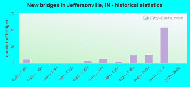
- New bridges - historical statistics
- 61920-1929
- 11950-1959
- 41960-1969
- 71970-1979
- 21980-1989
- 121990-1999
- 132000-2009
- 542010-2019
- 12020-2022
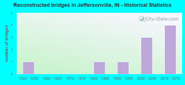
- Reconstructed bridges - Historical Statistics
- 11950-1959
- 01960-1969
- 01970-1979
- 11980-1989
- 11990-1999
- 32000-2009
- 42010-2019
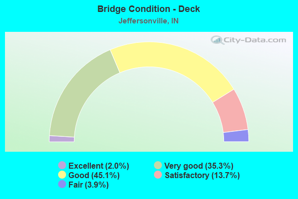
- Bridge Condition - Deck
- 2.0%Excellent
- 35.3%Very good
- 45.1%Good
- 13.7%Satisfactory
- 3.9%Fair
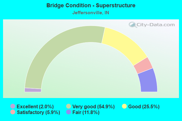
- Bridge Condition - Superstructure
- 2.0%Excellent
- 54.9%Very good
- 25.5%Good
- 5.9%Satisfactory
- 11.8%Fair
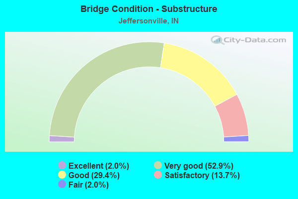
- Bridge Condition - Substructure
- 2.0%Excellent
- 52.9%Very good
- 29.4%Good
- 13.7%Satisfactory
- 2.0%Fair
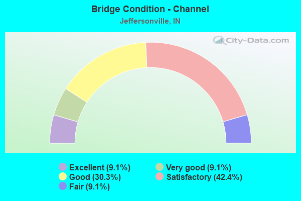
- Bridge Condition - Channel
- 9.1%Excellent
- 9.1%Very good
- 30.3%Good
- 42.4%Satisfactory
- 9.1%Fair
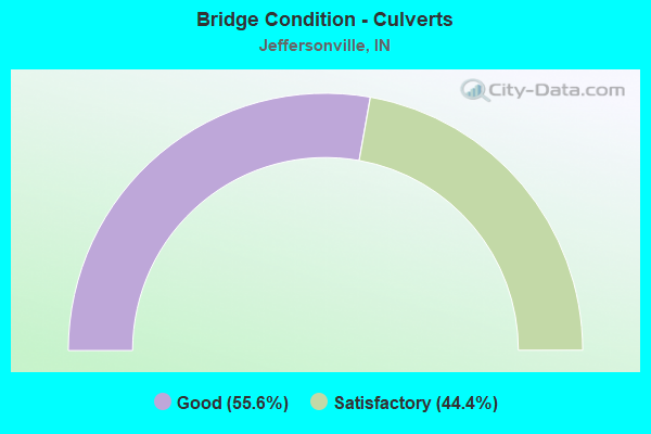
- Bridge Condition - Culverts
- 55.6%Good
- 44.4%Satisfactory
Find on map >> Show street view
Structure Number: 100015, Location: 0.50 N OF CR 1000 N (Lat: 40.897839, Lng: -84.938439), Route carried "on" structure: County highway , Year Built: 1975, Status: Open, Structure Length: 0.90m (2.95ft), Average Daily Traffic: 526 (year 2019), Truck Traffic: 5%, Average Future Daily Traffic: 352 (year 2039), Design Load: HS 20, Features Intersected: UPPER WEBER DITCH, Facility Carried by Structure: CR 000 E/W
Minimum Vertical Clearance: 30+ m (98+ ft), Kilometerpoint: 0.000, Lanes on structure: 2, Owner: County Highway Agency, Approaching Roadway Width: 5.5m (18.0ft), Skew: 2 degrees, Material/Design: Prestressed concrete, Design/Construction: Box Beam or Girders - Multiple, Number Of Spans In Main Unit: 1, Length of Maximum Span: 8.0m (26.2ft), Curb-To-Curb Width: 8.4m (27.6ft), Out-to-Out Width: 8.6m (28.2ft)
Condition: Deck: Fair, Superstructure: Fair, Substructure: Good, Channel: Satisfactory, Operating Rating: 58.7 metric tons, Method Used To Determine Operating Rating: Load Factor (LF), Inventory Rating: 35.2 metric tons, Method Used To Determine Inventory Rating: Load Factor (LF), Structural Evaluation: Somewhat better than minimum adequacy, Deck Geometry: Somewhat better than minimum adequacy, Waterway Adequacy: Equal to present minimum criteria, Approach Roadway Alignment: Equal to present desirable criteria, Length Of Structure Improvement: 0.91m (2.99ft), Designated Inspection Frequency: Every 24 months, Inspection Date: May 2020, Bridge Improvement Cost: $125,000, Roadway Improvement Cost: $100,000, Total Project Cost: $225,000 ( Estimate for 2020), Deck Structure Type: Concrete Precast Panels, Wearing Surface/Protective System: Wearing Surface: Bituminous
Find on map >> Show street view
Structure Number: 1000002, Location: 00.80 N of Cooper Lane (Lat: 38.356850, Lng: -85.684983), Route carried "on" structure: Alternate County highway , Year Built: 1988, Status: Open, Structure Length: 0.72m (2.36ft), Average Daily Traffic: 220 (year 2018), Truck Traffic: 3%, Average Future Daily Traffic: 380 (year 2038), Features Intersected: LENTZIER CREEK, Facility Carried by Structure: NEW CHAPEL ROAD
Minimum Vertical Clearance: 30+ m (98+ ft), Kilometerpoint: 0.000, Lanes on structure: 2, Owner: County Highway Agency, Approaching Roadway Width: 7.6m (24.9ft), Material/Design: Concrete, Design/Construction: Culvert, Number Of Spans In Main Unit: 2, Length of Maximum Span: 3.0m (9.8ft), Curb-To-Curb Width: 8.1m (26.6ft), Out-to-Out Width: 8.8m (28.9ft)
Condition: Channel: Satisfactory, Culverts: Good, Operating Rating: 32.7 metric tons, Method Used To Determine Operating Rating: Field evaluation and documented engineering judgment, Inventory Rating: 32.7 metric tons, Method Used To Determine Inventory Rating: Field evaluation and documented engineering judgment, Structural Evaluation: Better than present minimum criteria, Deck Geometry: Somewhat better than minimum adequacy, Waterway Adequacy: Equal to present minimum criteria, Approach Roadway Alignment: Equal to present desirable criteria, Designated Inspection Frequency: Every 24 months, Inspection Date: March 2020, Wearing Surface/Protective System: Wearing Surface: Bituminous
Find on map >> Show street view
Structure Number: 1000004, Location: 00.10 NE of Hamburg Pike (Lat: 38.342931, Lng: -85.742761), Route carried "on" structure: City street , Year Built: 2003, Status: Open, Structure Length: 1.16m (3.81ft), Average Daily Traffic: 5,600 (year 2018), Truck Traffic: 6%, Average Future Daily Traffic: 9,740 (year 2038), Features Intersected: LICK RUN, Facility Carried by Structure: COOPER ROAD
Minimum Vertical Clearance: 30+ m (98+ ft), Kilometerpoint: 0.000, Lanes on structure: 2, Owner: County Highway Agency, Approaching Roadway Width: 7.0m (23.0ft), Skew: 1 degrees, Material/Design: Steel, Design/Construction: Stringer/Multi-beam, Number Of Spans In Main Unit: 1, Length of Maximum Span: 10.4m (34.1ft), Curb-To-Curb Width: 8.7m (28.5ft), Out-to-Out Width: 9.2m (30.2ft)
Condition: Deck: Good, Superstructure: Good, Substructure: Good, Channel: Good, Operating Rating: 62.7 metric tons, Method Used To Determine Operating Rating: Load Factor (LF), Inventory Rating: 37.5 metric tons, Method Used To Determine Inventory Rating: Load Factor (LF), Structural Evaluation: Better than present minimum criteria, Deck Geometry: High priority of replacement, Waterway Adequacy: Better than present minimum criteria, Approach Roadway Alignment: Equal to present minimum criteria, Designated Inspection Frequency: Every 24 months, Inspection Date: March 2020, Deck Structure Type: Concrete Cast-file-Place, Wearing Surface/Protective System: Wearing Surface: Monolithic Concrete
Find on map >> Show street view
Structure Number: 1000009, Location: 00.80 S of Bean Road (Lat: 38.370992, Lng: -85.726525), Route carried "on" structure: County highway , Year Built: 1983, Status: Open, Structure Length: 5.14m (16.86ft), Average Daily Traffic: 800 (year 2018), Truck Traffic: 6%, Average Future Daily Traffic: 1,390 (year 2038), Features Intersected: SILVER CREEK, Facility Carried by Structure: SELLERSBURG ROAD
Minimum Vertical Clearance: 30+ m (98+ ft), Kilometerpoint: 0.000, Lanes on structure: 2, Owner: County Highway Agency, Approaching Roadway Width: 7.9m (25.9ft), Material/Design: Prestressed concrete continuous, Design/Construction: Stringer/Multi-beam, Number Of Spans In Main Unit: 3, Length of Maximum Span: 19.4m (63.6ft), Curb-To-Curb Width: 9.8m (32.2ft), Out-to-Out Width: 10.6m (34.8ft)
Condition: Deck: Good, Superstructure: Good, Substructure: Good, Channel: Very good, Operating Rating: 32.7 metric tons, Method Used To Determine Operating Rating: Field evaluation and documented engineering judgment, Inventory Rating: 32.7 metric tons, Method Used To Determine Inventory Rating: Field evaluation and documented engineering judgment, Structural Evaluation: Better than present minimum criteria, Deck Geometry: Equal to present minimum criteria, Waterway Adequacy: Equal to present desirable criteria, Approach Roadway Alignment: Equal to present minimum criteria, Designated Inspection Frequency: Every 24 months, Inspection Date: March 2020, Deck Structure Type: Concrete Cast-file-Place, Wearing Surface/Protective System: Wearing Surface: Monolithic Concrete, Deck Protection: Epoxy Coated Reinforcing
Find on map >> Show street view
Structure Number: 100001, Location: 01.10 NW of Cooper Lane (Lat: 38.408289, Lng: -85.703453), Route carried "on" structure: Alternate County highway , Year Built: 1975, Status: Open, Structure Length: 2.39m (7.84ft), Average Daily Traffic: 220 (year 2018), Truck Traffic: 3%, Average Future Daily Traffic: 380 (year 2038), Features Intersected: PLEASANT RUN, Facility Carried by Structure: STACEY ROAD
Minimum Vertical Clearance: 30+ m (98+ ft), Kilometerpoint: 0.000, Lanes on structure: 2, Owner: County Highway Agency, Approaching Roadway Width: 7.0m (23.0ft), Material/Design: Prestressed concrete, Design/Construction: Stringer/Multi-beam, Number Of Spans In Main Unit: 1, Length of Maximum Span: 22.6m (74.1ft), Curb-To-Curb Width: 8.4m (27.6ft), Out-to-Out Width: 9.2m (30.2ft)
Condition: Deck: Satisfactory, Superstructure: Fair, Substructure: Satisfactory, Channel: Good, Operating Rating: 82.3 metric tons, Method Used To Determine Operating Rating: Load and Resistance Factor (LRFR), Inventory Rating: 47.1 metric tons, Method Used To Determine Inventory Rating: Load and Resistance Factor (LRFR), Structural Evaluation: Somewhat better than minimum adequacy, Deck Geometry: Somewhat better than minimum adequacy, Waterway Adequacy: Equal to present desirable criteria, Approach Roadway Alignment: Equal to present desirable criteria, Designated Inspection Frequency: Every 24 months, Inspection Date: March 2020, Deck Structure Type: Concrete Cast-file-Place, Wearing Surface/Protective System: Wearing Surface: Monolithic Concrete
Find on map >> Show street view
Structure Number: 1000089, Location: 00.00 S of Patrol Street (Lat: 38.362550, Lng: -85.642808), Route carried "on" structure: County highway , Year Built: 1950, Year Reconstructed: 1985, Status: Open, Structure Length: 0.79m (2.59ft), Average Daily Traffic: 1,050 (year 2018), Truck Traffic: 6%, Average Future Daily Traffic: 1,830 (year 2038), Features Intersected: BATTLE CREEK, Facility Carried by Structure: UTICA PIKE
Minimum Vertical Clearance: 30+ m (98+ ft), Kilometerpoint: 0.000, Lanes on structure: 2, Owner: County Highway Agency, Approaching Roadway Width: 6.4m (21.0ft), Skew: 1 degrees, Material/Design: Steel continuous, Design/Construction: Stringer/Multi-beam, Number Of Spans In Main Unit: 2, Length of Maximum Span: 3.6m (11.8ft), Curb-To-Curb Width: 7.8m (25.6ft), Out-to-Out Width: 7.9m (25.9ft)
Condition: Deck: Satisfactory, Superstructure: Fair, Substructure: Satisfactory, Channel: Fair, Operating Rating: 71.6 metric tons, Method Used To Determine Operating Rating: Load Factor (LF), Inventory Rating: 42.8 metric tons, Method Used To Determine Inventory Rating: Load Factor (LF), Structural Evaluation: Somewhat better than minimum adequacy, Deck Geometry: Meets minimum limits, Waterway Adequacy: Equal to present minimum criteria, Approach Roadway Alignment: Equal to present desirable criteria, Designated Inspection Frequency: Every 24 months, Inspection Date: March 2020, Deck Structure Type: Concrete Cast-file-Place, Wearing Surface/Protective System: Wearing Surface: Bituminous, Deck Protection: Epoxy Coated Reinforcing
Find on map >> Show street view
Structure Number: 1000101, Location: 00.10 NW of Middle Road (Lat: 38.320489, Lng: -85.694861), Route carried "on" structure: Alternate City street , Year Built: 1975, Status: Open, Structure Length: 1.34m (4.40ft), Average Daily Traffic: 1,020 (year 2018), Truck Traffic: 3%, Average Future Daily Traffic: 1,770 (year 2038), Features Intersected: LANCASSANGE CREEK, Facility Carried by Structure: CAPITOL HILL DR
Minimum Vertical Clearance: 30+ m (98+ ft), Kilometerpoint: 0.000, Lanes on structure: 2, Owner: County Highway Agency, Approaching Roadway Width: 10.7m (35.1ft), Material/Design: Prestressed concrete, Design/Construction: Box Beam or Girders - Multiple, Number Of Spans In Main Unit: 1, Length of Maximum Span: 12.8m (42.0ft), Curb or Sidewalk Widths: Left: 0.9m (3.0ft), Right: 0.9m (3.0ft), Curb-To-Curb Width: 8.1m (26.6ft), Out-to-Out Width: 9.8m (32.2ft)
Condition: Deck: Satisfactory, Superstructure: Satisfactory, Substructure: Satisfactory, Channel: Good, Operating Rating: 49.0 metric tons, Method Used To Determine Operating Rating: Load and Resistance Factor (LRFR), Inventory Rating: 30.8 metric tons, Method Used To Determine Inventory Rating: Load and Resistance Factor (LRFR), Structural Evaluation: Equal to present minimum criteria, Deck Geometry: Meets minimum limits, Waterway Adequacy: Equal to present desirable criteria, Approach Roadway Alignment: Equal to present minimum criteria, Designated Inspection Frequency: Every 24 months, Inspection Date: March 2020, Deck Structure Type: Concrete Precast Panels, Wearing Surface/Protective System: Wearing Surface: Bituminous
Find on map >> Show street view
Structure Number: 1000102, Location: 00.20 NW of Middle Road (Lat: 38.319419, Lng: -85.698647), Route carried "on" structure: Alternate City street , Year Built: 1975, Status: Open, Structure Length: 1.34m (4.40ft), Average Daily Traffic: 1,040 (year 2018), Truck Traffic: 3%, Average Future Daily Traffic: 1,810 (year 2038), Features Intersected: LANCASSANGE CREEK, Facility Carried by Structure: PRESIDENTAL PLACE
Minimum Vertical Clearance: 30+ m (98+ ft), Kilometerpoint: 0.000, Lanes on structure: 2, Owner: County Highway Agency, Approaching Roadway Width: 11.4m (37.4ft), Material/Design: Prestressed concrete, Design/Construction: Box Beam or Girders - Multiple, Number Of Spans In Main Unit: 1, Length of Maximum Span: 12.7m (41.7ft), Curb or Sidewalk Widths: Left: 0.9m (3.0ft), Right: 0.9m (3.0ft), Curb-To-Curb Width: 7.4m (24.3ft), Out-to-Out Width: 9.1m (29.9ft)
Condition: Deck: Good, Superstructure: Good, Substructure: Good, Channel: Satisfactory, Operating Rating: 47.2 metric tons, Method Used To Determine Operating Rating: Load and Resistance Factor (LRFR), Inventory Rating: 35.2 metric tons, Method Used To Determine Inventory Rating: Load and Resistance Factor (LRFR), Structural Evaluation: Better than present minimum criteria, Deck Geometry: Meets minimum limits, Waterway Adequacy: Equal to present desirable criteria, Approach Roadway Alignment: Equal to present minimum criteria, Designated Inspection Frequency: Every 24 months, Inspection Date: March 2020, Deck Structure Type: Concrete Precast Panels, Wearing Surface/Protective System: Wearing Surface: Bituminous
Find on map >> Show street view
Structure Number: 1000109, Location: 00.20 NW of Middle Road (Lat: 38.313739, Lng: -85.704764), Route carried "on" structure: City street , Year Built: 1965, Status: Open, Structure Length: 1.30m (4.27ft), Average Daily Traffic: 19,740 (year 2018), Truck Traffic: 9%, Average Future Daily Traffic: 34,350 (year 2038), Features Intersected: MILL CREEK, Facility Carried by Structure: ALLISON LANE
Minimum Vertical Clearance: 30+ m (98+ ft), Kilometerpoint: 0.000, Lanes on structure: 2, Owner: County Highway Agency, Approaching Roadway Width: 7.9m (25.9ft), Material/Design: Concrete continuous, Design/Construction: Slab, Number Of Spans In Main Unit: 3, Length of Maximum Span: 5.3m (17.4ft), Curb-To-Curb Width: 12.3m (40.4ft), Out-to-Out Width: 12.8m (42.0ft)
Condition: Deck: Fair, Superstructure: Fair, Substructure: Satisfactory, Channel: Fair, Operating Rating: 32.7 metric tons, Method Used To Determine Operating Rating: Field evaluation and documented engineering judgment, Inventory Rating: 32.7 metric tons, Method Used To Determine Inventory Rating: Field evaluation and documented engineering judgment, Structural Evaluation: Somewhat better than minimum adequacy, Deck Geometry: Somewhat better than minimum adequacy, Waterway Adequacy: Equal to present minimum criteria, Approach Roadway Alignment: Equal to present desirable criteria, Designated Inspection Frequency: Every 24 months, Inspection Date: March 2020, Deck Structure Type: Concrete Cast-file-Place, Wearing Surface/Protective System: Wearing Surface: Bituminous
Find on map >> Show street view
Structure Number: 100011, Location: 00.00 S of Woodlawn Avenu (Lat: 38.298300, Lng: -85.745322), Route carried "on" structure: City street , Year Built: 1970, Year Reconstructed: 2012, Status: Open, Structure Length: 3.29m (10.79ft), Average Daily Traffic: 11,970 (year 2018), Truck Traffic: 8%, Average Future Daily Traffic: 20,830 (year 2038), Design Load: HS 25 or greater, Features Intersected: MILL CREEK, Facility Carried by Structure: HAMBURG PIKE
Minimum Vertical Clearance: 30+ m (98+ ft), Kilometerpoint: 0.000, Lanes on structure: 2, Owner: County Highway Agency, Approaching Roadway Width: 12.5m (41.0ft), Skew: 4 degrees, Material/Design: Prestressed concrete, Design/Construction: Box Beam or Girders - Multiple, Number Of Spans In Main Unit: 3, Length of Maximum Span: 11.0m (36.1ft), Curb or Sidewalk Widths: Left: 2.0m (6.6ft), Right: 2.0m (6.6ft), Curb-To-Curb Width: 12.5m (41.0ft), Out-to-Out Width: 17.1m (56.1ft)
Condition: Deck: Very good, Superstructure: Very good, Substructure: Good, Channel: Satisfactory, Inventory Rating: 81.6 metric tons, Method Used To Determine Inventory Rating: Load and Resistance Factor (LRFR), Structural Evaluation: Better than present minimum criteria, Deck Geometry: Somewhat better than minimum adequacy, Waterway Adequacy: Somewhat better than minimum adequacy, Approach Roadway Alignment: Equal to present desirable criteria, Designated Inspection Frequency: Every 24 months, Inspection Date: March 2020, Deck Structure Type: Concrete Cast-file-Place, Wearing Surface/Protective System: Wearing Surface: Monolithic Concrete, Deck Protection: Epoxy Coated Reinforcing
Find on map >> Show street view
Structure Number: 1000111, Location: 00.10 N EASTERN BLVD (Lat: 38.294239, Lng: -85.755578), Route carried "on" structure: City street , Year Built: 1962, Year Reconstructed: 2000, Status: Open, Structure Length: 1.20m (3.94ft), Average Daily Traffic: 200 (year 2018), Truck Traffic: 5%, Average Future Daily Traffic: 350 (year 2038), Features Intersected: MILL CREEK, Facility Carried by Structure: HOSPITALITY WAY
Minimum Vertical Clearance: 30+ m (98+ ft), Kilometerpoint: 0.000, Lanes on structure: 2, Owner: County Highway Agency, Approaching Roadway Width: 6.7m (22.0ft), Skew: 1 degrees, Material/Design: Concrete, Design/Construction: Culvert, Number Of Spans In Main Unit: 3, Length of Maximum Span: 4.0m (13.1ft), Curb-To-Curb Width: 8.5m (27.9ft), Out-to-Out Width: 8.5m (27.9ft)
Condition: Channel: Satisfactory, Culverts: Good, Operating Rating: 32.7 metric tons, Method Used To Determine Operating Rating: Field evaluation and documented engineering judgment, Inventory Rating: 32.7 metric tons, Method Used To Determine Inventory Rating: Field evaluation and documented engineering judgment, Structural Evaluation: Better than present minimum criteria, Deck Geometry: Equal to present minimum criteria, Waterway Adequacy: Equal to present desirable criteria, Approach Roadway Alignment: Equal to present minimum criteria, Designated Inspection Frequency: Every 24 months, Inspection Date: March 2020, Wearing Surface/Protective System: Wearing Surface: Monolithic Concrete
Find on map >> Show street view
Structure Number: 1000112, Location: 00.10 E I-65 (Lat: 38.293989, Lng: -85.755867), Route carried "on" structure: City street , Year Built: 1962, Year Reconstructed: 2000, Status: Open, Structure Length: 1.20m (3.94ft), Average Daily Traffic: 34,930 (year 2018), Truck Traffic: 5%, Average Future Daily Traffic: 60,780 (year 2038), Features Intersected: MILL CREEK, Facility Carried by Structure: EASTERN BOULEVARD
Minimum Vertical Clearance: 30+ m (98+ ft), Kilometerpoint: 0.000, Lanes on structure: 4, Owner: City or Municipal Highway Agency, Approaching Roadway Width: 19.5m (64.0ft), Skew: 20 degrees, Material/Design: Concrete, Design/Construction: Culvert, Number Of Spans In Main Unit: 3, Length of Maximum Span: 3.7m (12.1ft), Curb or Sidewalk Widths: Left: 1.2m (3.9ft), Right: 1.2m (3.9ft), Curb-To-Curb Width: 19.5m (64.0ft), Out-to-Out Width: 21.9m (71.9ft)
Condition: Channel: Good, Culverts: Satisfactory, Operating Rating: 32.7 metric tons, Method Used To Determine Operating Rating: Field evaluation and documented engineering judgment, Inventory Rating: 32.7 metric tons, Method Used To Determine Inventory Rating: Field evaluation and documented engineering judgment, Structural Evaluation: Equal to present minimum criteria, Deck Geometry: Better than present minimum criteria, Waterway Adequacy: Better than present minimum criteria, Approach Roadway Alignment: Equal to present desirable criteria, Designated Inspection Frequency: Every 24 months, Inspection Date: March 2020, Wearing Surface/Protective System: Wearing Surface: Monolithic Concrete
Find on map >> Show street view
Structure Number: 1000117, Location: 00.20 N of Spring Street (Lat: 38.297478, Lng: -85.749167), Route carried "on" structure: Alternate City street , Year Built: 1970, Year Reconstructed: 1999, Status: Posted for load-capacity, Structure Length: 2.24m (7.35ft), Average Daily Traffic: 90 (year 2018), Truck Traffic: 50%, Average Future Daily Traffic: 160 (year 2038), Features Intersected: MILL Creek, Facility Carried by Structure: WILLINGER LN
Minimum Vertical Clearance: 30+ m (98+ ft), Kilometerpoint: 0.000, Lanes on structure: 1, Owner: County Highway Agency, Approaching Roadway Width: 3.7m (12.1ft), Material/Design: Steel continuous, Design/Construction: Stringer/Multi-beam, Number Of Spans In Main Unit: 2, Length of Maximum Span: 11.3m (37.1ft), Curb-To-Curb Width: 4.2m (13.8ft), Out-to-Out Width: 4.3m (14.1ft)
Condition: Deck: Satisfactory, Superstructure: Satisfactory, Substructure: Satisfactory, Channel: Fair, Operating Rating: 61.1 metric tons, Method Used To Determine Operating Rating: Load Factor (LF), Inventory Rating: 36.6 metric tons, Method Used To Determine Inventory Rating: Load Factor (LF), Structural Evaluation: Equal to present minimum criteria, Deck Geometry: Somewhat better than minimum adequacy, Waterway Adequacy: Better than present minimum criteria, Approach Roadway Alignment: Equal to present minimum criteria, Length Of Structure Improvement: 3.05m (10.01ft), Designated Inspection Frequency: Every 24 months, Inspection Date: March 2020, Bridge Improvement Cost: $522,000, Roadway Improvement Cost: $234,000, Total Project Cost: $954,000 ( Estimate for 2020), Deck Structure Type: Wood or Timber, Wearing Surface/Protective System: Wearing Surface: Bituminous
Find on map >> Show street view
Structure Number: 1000118, Location: 00.10 N of Redbud Road (Lat: 38.312731, Lng: -85.694031), Route carried "on" structure: Alternate City street , Year Built: 1994, Status: Open, Structure Length: 1.14m (3.74ft), Average Daily Traffic: 440 (year 2018), Truck Traffic: 3%, Average Future Daily Traffic: 770 (year 2038), Features Intersected: LANCASSANGE CREEK, Facility Carried by Structure: LANCASSANGE DRIVE
Minimum Vertical Clearance: 30+ m (98+ ft), Kilometerpoint: 0.000, Lanes on structure: 2, Owner: County Highway Agency, Approaching Roadway Width: 6.4m (21.0ft), Material/Design: Prestressed concrete, Design/Construction: Box Beam or Girders - Multiple, Number Of Spans In Main Unit: 1, Length of Maximum Span: 10.1m (33.1ft), Curb-To-Curb Width: 7.4m (24.3ft), Out-to-Out Width: 8.7m (28.5ft)
Condition: Deck: Good, Superstructure: Good, Substructure: Good, Channel: Satisfactory, Operating Rating: 32.7 metric tons, Method Used To Determine Operating Rating: Field evaluation and documented engineering judgment, Inventory Rating: 32.7 metric tons, Method Used To Determine Inventory Rating: Field evaluation and documented engineering judgment, Structural Evaluation: Better than present minimum criteria, Deck Geometry: Meets minimum limits, Waterway Adequacy: Equal to present desirable criteria, Approach Roadway Alignment: Equal to present minimum criteria, Designated Inspection Frequency: Every 24 months, Inspection Date: March 2020, Deck Structure Type: Concrete Precast Panels, Wearing Surface/Protective System: Wearing Surface: Monolithic Concrete, Deck Protection: Epoxy Coated Reinforcing
Find on map >> Show street view
Structure Number: 1000119, Location: 00.10 S MIDDLE RD (Lat: 38.311150, Lng: -85.702422), Route carried "on" structure: City street , Year Built: 1996, Status: Open, Structure Length: 0.98m (3.22ft), Average Daily Traffic: 19,710 (year 2018), Truck Traffic: 9%, Average Future Daily Traffic: 34,300 (year 2038), Features Intersected: LANCASSANGE CREEK, Facility Carried by Structure: ALLISON LN
Minimum Vertical Clearance: 30+ m (98+ ft), Kilometerpoint: 0.000, Lanes on structure: 3, Owner: County Highway Agency, Approaching Roadway Width: 12.3m (40.4ft), Skew: 10 degrees, Material/Design: Concrete, Design/Construction: Culvert, Number Of Spans In Main Unit: 1, Length of Maximum Span: 9.1m (29.9ft), Curb or Sidewalk Widths: Left: 1.9m (6.2ft), Right: 1.9m (6.2ft), Curb-To-Curb Width: 12.3m (40.4ft), Out-to-Out Width: 17.2m (56.4ft)
Condition: Channel: Good, Culverts: Satisfactory, Operating Rating: 32.7 metric tons, Method Used To Determine Operating Rating: Field evaluation and documented engineering judgment, Inventory Rating: 32.7 metric tons, Method Used To Determine Inventory Rating: Field evaluation and documented engineering judgment, Structural Evaluation: Equal to present minimum criteria, Deck Geometry: Meets minimum limits, Waterway Adequacy: Equal to present desirable criteria, Approach Roadway Alignment: Equal to present desirable criteria, Designated Inspection Frequency: Every 24 months, Inspection Date: March 2020, Wearing Surface/Protective System: Wearing Surface: Monolithic Concrete, Deck Protection: Epoxy Coated Reinforcing
Find on map >> Show street view
Structure Number: 100012, Location: 00.10 W ALLISON LN (Lat: 38.310911, Lng: -85.703300), Route carried "on" structure: City street , Year Built: 1996, Status: Open, Structure Length: 0.91m (2.99ft), Average Daily Traffic: 23,400 (year 2018), Truck Traffic: 9%, Average Future Daily Traffic: 40,720 (year 2038), Features Intersected: LANCASSANGE CREEK, Facility Carried by Structure: MIDDLE RD
Minimum Vertical Clearance: 30+ m (98+ ft), Kilometerpoint: 0.000, Lanes on structure: 3, Owner: County Highway Agency, Approaching Roadway Width: 12.4m (40.7ft), Material/Design: Concrete, Design/Construction: Culvert, Number Of Spans In Main Unit: 1, Length of Maximum Span: 8.5m (27.9ft), Curb or Sidewalk Widths: Left: 1.8m (5.9ft), Right: 1.8m (5.9ft), Curb-To-Curb Width: 12.4m (40.7ft), Out-to-Out Width: 16.9m (55.4ft)
Condition: Channel: Satisfactory, Culverts: Satisfactory, Operating Rating: 32.7 metric tons, Method Used To Determine Operating Rating: Field evaluation and documented engineering judgment, Inventory Rating: 32.7 metric tons, Method Used To Determine Inventory Rating: Field evaluation and documented engineering judgment, Structural Evaluation: Equal to present minimum criteria, Deck Geometry: Meets minimum limits, Waterway Adequacy: Better than present minimum criteria, Approach Roadway Alignment: Equal to present minimum criteria, Designated Inspection Frequency: Every 24 months, Inspection Date: March 2020, Wearing Surface/Protective System: Wearing Surface: Monolithic Concrete
Find on map >> Show street view
Structure Number: 1000128, Location: 00.20 NE of Scott Drive (Lat: 38.338158, Lng: -85.737708), Route carried "on" structure: Alternate City street , Year Built: 2000, Status: Open, Structure Length: 0.67m (2.20ft), Average Daily Traffic: 420 (year 2018), Truck Traffic: 3%, Average Future Daily Traffic: 790 (year 2038), Features Intersected: LICK RUN BRANCH, Facility Carried by Structure: CRUMS LN
Minimum Vertical Clearance: 30+ m (98+ ft), Kilometerpoint: 0.000, Lanes on structure: 2, Owner: County Highway Agency, Approaching Roadway Width: 9.8m (32.2ft), Material/Design: Concrete, Design/Construction: Culvert, Number Of Spans In Main Unit: 1, Length of Maximum Span: 6.1m (20.0ft), Curb or Sidewalk Widths: Left: 1.2m (3.9ft), Right: 1.2m (3.9ft), Curb-To-Curb Width: 9.8m (32.2ft), Out-to-Out Width: 12.2m (40.0ft)
Condition: Channel: Good, Culverts: Good, Operating Rating: 32.7 metric tons, Method Used To Determine Operating Rating: Field evaluation and documented engineering judgment, Inventory Rating: 32.7 metric tons, Method Used To Determine Inventory Rating: Field evaluation and documented engineering judgment, Structural Evaluation: Better than present minimum criteria, Deck Geometry: Equal to present minimum criteria, Waterway Adequacy: Equal to present desirable criteria, Approach Roadway Alignment: Equal to present desirable criteria, Designated Inspection Frequency: Every 24 months, Inspection Date: March 2020, Wearing Surface/Protective System: Wearing Surface: Bituminous
Find on map >> Show street view
Structure Number: 1000129, Location: 00.00 N PENSIVE RD (Lat: 38.312008, Lng: -85.789672), Route carried "on" structure: City street , Year Built: 2004, Status: Open, Structure Length: 0.73m (2.40ft), Average Daily Traffic: 570 (year 2018), Truck Traffic: 5%, Average Future Daily Traffic: 990 (year 2038), Features Intersected: BR SILVER CREEK, Facility Carried by Structure: GUTFORD ROAD
Minimum Vertical Clearance: 30+ m (98+ ft), Kilometerpoint: 0.000, Lanes on structure: 2, Owner: County Highway Agency, Approaching Roadway Width: 6.7m (22.0ft), Skew: 1 degrees, Material/Design: Concrete, Design/Construction: Culvert, Number Of Spans In Main Unit: 1, Length of Maximum Span: 7.3m (24.0ft), Curb-To-Curb Width: 10.2m (33.5ft), Out-to-Out Width: 10.2m (33.5ft)
Condition: Channel: Satisfactory, Culverts: Good, Operating Rating: 32.7 metric tons, Method Used To Determine Operating Rating: Field evaluation and documented engineering judgment, Inventory Rating: 32.7 metric tons, Method Used To Determine Inventory Rating: Field evaluation and documented engineering judgment, Structural Evaluation: Better than present minimum criteria, Deck Geometry: Equal to present minimum criteria, Waterway Adequacy: Better than present minimum criteria, Approach Roadway Alignment: Equal to present minimum criteria, Designated Inspection Frequency: Every 24 months, Inspection Date: March 2020, Wearing Surface/Protective System: Wearing Surface: Bituminous
Find on map >> Show street view
Structure Number: 1000132, Location: 00.20 SW of Capitl Hills (Lat: 38.324992, Lng: -85.701942), Route carried "on" structure: City street , Year Built: 2005, Status: Open, Structure Length: 0.65m (2.13ft), Average Daily Traffic: 210 (year 2018), Truck Traffic: 3%, Average Future Daily Traffic: 370 (year 2038), Features Intersected: BRANCH OF LANCASSANGE CR, Facility Carried by Structure: SEILO RIDGE N
Minimum Vertical Clearance: 30+ m (98+ ft), Kilometerpoint: 0.000, Lanes on structure: 2, Owner: County Highway Agency, Approaching Roadway Width: 8.2m (26.9ft), Material/Design: Concrete, Design/Construction: Culvert, Number Of Spans In Main Unit: 3, Length of Maximum Span: 2.0m (6.6ft), Curb or Sidewalk Widths: Left: 1.5m (4.9ft), Right: 1.2m (3.9ft), Curb-To-Curb Width: 9.4m (30.8ft), Out-to-Out Width: 12.1m (39.7ft)
Condition: Channel: Satisfactory, Culverts: Good, Operating Rating: 32.7 metric tons, Method Used To Determine Operating Rating: Field evaluation and documented engineering judgment, Inventory Rating: 32.7 metric tons, Method Used To Determine Inventory Rating: Field evaluation and documented engineering judgment, Structural Evaluation: Better than present minimum criteria, Deck Geometry: Equal to present minimum criteria, Waterway Adequacy: Better than present minimum criteria, Approach Roadway Alignment: Equal to present minimum criteria, Designated Inspection Frequency: Every 24 months, Inspection Date: March 2020, Wearing Surface/Protective System: Wearing Surface: Bituminous
Find on map >> Show street view
Structure Number: 1000133, Location: 00.10 N of Washington Way (Lat: 38.324242, Lng: -85.701256), Route carried "on" structure: City street , Year Built: 2005, Status: Open, Structure Length: 0.62m (2.03ft), Average Daily Traffic: 210 (year 2018), Truck Traffic: 3%, Average Future Daily Traffic: 370 (year 2038), Features Intersected: BRANCH OF LANCASSANGE CR, Facility Carried by Structure: BLUEBERRY WAY
Minimum Vertical Clearance: 30+ m (98+ ft), Kilometerpoint: 0.000, Lanes on structure: 2, Owner: County Highway Agency, Approaching Roadway Width: 8.2m (26.9ft), Material/Design: Concrete, Design/Construction: Culvert, Number Of Spans In Main Unit: 3, Length of Maximum Span: 1.6m (5.2ft), Curb or Sidewalk Widths: Left: 1.2m (3.9ft), Right: 1.4m (4.6ft), Curb-To-Curb Width: 8.2m (26.9ft), Out-to-Out Width: 12.0m (39.4ft)
Condition: Channel: Satisfactory, Culverts: Satisfactory, Operating Rating: 32.7 metric tons, Method Used To Determine Operating Rating: Field evaluation and documented engineering judgment, Inventory Rating: 32.7 metric tons, Method Used To Determine Inventory Rating: Field evaluation and documented engineering judgment, Structural Evaluation: Equal to present minimum criteria, Deck Geometry: Somewhat better than minimum adequacy, Waterway Adequacy: Better than present minimum criteria, Approach Roadway Alignment: Equal to present minimum criteria, Designated Inspection Frequency: Every 24 months, Inspection Date: March 2020, Wearing Surface/Protective System: Wearing Surface: Bituminous
Find on map >> Show street view
Structure Number: 1000153, Location: 01.80 NW SR 62 (Lat: 38.389611, Lng: -85.707886), Route carried "on" structure: County highway , Year Built: 2017, Status: Open, Structure Length: 3.75m (12.30ft), Average Daily Traffic: 610 (year 2018), Truck Traffic: 4%, Average Future Daily Traffic: 1,060 (year 2038), Features Intersected: PLEASANT RUN, Facility Carried by Structure: SALEM NOBLE RD
Minimum Vertical Clearance: 30+ m (98+ ft), Kilometerpoint: 0.000, Lanes on structure: 2, Owner: County Highway Agency, Approaching Roadway Width: 7.9m (25.9ft), Material/Design: Steel, Design/Construction: Truss - Thru, Number Of Spans In Main Unit: 1, Length of Maximum Span: 35.4m (116.1ft), Curb-To-Curb Width: 10.4m (34.1ft), Out-to-Out Width: 10.9m (35.8ft)
Condition: Deck: Very good, Superstructure: Very good, Substructure: Very good, Channel: Satisfactory, Operating Rating: 46.9 metric tons, Method Used To Determine Operating Rating: Load Factor (LF), Inventory Rating: 28.1 metric tons, Method Used To Determine Inventory Rating: Load Factor (LF), Structural Evaluation: Better than present minimum criteria, Deck Geometry: Equal to present minimum criteria, Waterway Adequacy: Better than present minimum criteria, Approach Roadway Alignment: Equal to present desirable criteria, Designated Inspection Frequency: Every 24 months, Critical Feature Inspection Frequency: Every 24 months, Inspection Date: March 2020, Critical Feature Inspection Date: March 2020, Deck Structure Type: Concrete Cast-file-Place, Wearing Surface/Protective System: Wearing Surface: Monolithic Concrete, Deck Protection: Epoxy Coated Reinforcing
Find on map >> Show street view
Structure Number: 1000155, Location: .23 SW OF UTICA SELLE. RD (Lat: 38.351231, Lng: -85.708519), Route carried "on" structure: City street , Year Built: 2000, Status: Open, Structure Length: 2.99m (9.81ft), Average Daily Traffic: 260 (year 2018), Truck Traffic: 5%, Average Future Daily Traffic: 400 (year 2038), Design Load: HL 93, Features Intersected: CSXTRR, Facility Carried by Structure: KEYSTONE BLVD.
Minimum Vertical Clearance: 30+ m (98+ ft), Kilometerpoint: 0.000, Lanes on structure: 2, Owner: County Highway Agency, Approaching Roadway Width: 9.1m (29.9ft), Material/Design: Prestressed concrete, Design/Construction: Stringer/Multi-beam, Number Of Spans In Main Unit: 1, Length of Maximum Span: 29.0m (95.1ft), Curb-To-Curb Width: 9.8m (32.2ft), Out-to-Out Width: 10.7m (35.1ft)
Condition: Deck: Good, Superstructure: Very good, Substructure: Very good, Operating Rating: 32.7 metric tons, Method Used To Determine Operating Rating: Field evaluation and documented engineering judgment, Inventory Rating: 32.7 metric tons, Method Used To Determine Inventory Rating: Field evaluation and documented engineering judgment, Structural Evaluation: Equal to present desirable criteria, Deck Geometry: Better than present minimum criteria, Underclear: Meets minimum limits, Approach Roadway Alignment: Equal to present minimum criteria, Designated Inspection Frequency: Every 24 months, Inspection Date: March 2020, Deck Structure Type: Concrete Cast-file-Place, Wearing Surface/Protective System: Wearing Surface: Monolithic Concrete, Deck Protection: Epoxy Coated Reinforcing
Find on map >> Show street view
Structure Number: 1000157, Location: 0.44 S SR-265 (Lat: 38.342219, Lng: -85.668611), Route carried "on" structure: County highway , Year Built: 2021, Status: Open, Structure Length: 14.86m (48.75ft), Average Daily Traffic: 8,800 (year 2020), Truck Traffic: 29%, Average Future Daily Traffic: 16,700 (year 2040), Design Load: HL 93, Features Intersected: LENTZIER CREEK, Facility Carried by Structure: HEAVY HAUL ROAD
Minimum Vertical Clearance: 30+ m (98+ ft), Kilometerpoint: 0.000, Lanes on structure: 2, Owner: State Highway Agency, Approaching Roadway Width: 14.3m (46.9ft), Skew: 4 degrees, Material/Design: Prestressed concrete continuous, Design/Construction: Tee Beam, Number Of Spans In Main Unit: 3, Length of Maximum Span: 49.1m (161.1ft), Curb-To-Curb Width: 14.4m (47.2ft), Out-to-Out Width: 15.3m (50.2ft)
Condition: Deck: Excellent, Superstructure: Excellent, Substructure: Excellent, Channel: Excellent, Operating Rating: 48.6 metric tons, Method Used To Determine Operating Rating: Load and Resistance Factor Rating (LRFR) rating reported by rating factor(RF) method using HL-93 loadings, Inventory Rating: 37.3 metric tons, Method Used To Determine Inventory Rating: Load and Resistance Factor Rating (LRFR) rating reported by rating factor(RF) method using HL-93 loadings, Structural Evaluation: Superior to present desirable criteria, Deck Geometry: Superior to present desirable criteria, Waterway Adequacy: Superior to present desirable criteria, Approach Roadway Alignment: Equal to present desirable criteria, Designated Inspection Frequency: Every 24 months, Inspection Date: January 2022, Deck Structure Type: Concrete Cast-file-Place, Wearing Surface/Protective System: Wearing Surface: Monolithic Concrete, Deck Protection: Epoxy Coated Reinforcing
Find on map >> Show street view
Structure Number: 8868, Location: 00.62 S SR 62X (Lat: 38.263889, Lng: -85.751611), Route carried "under" structure: Interstate 64, Year Built: 1929, Structure Length: 0. m, Average Daily Traffic: 28,000 (year 2007), Truck Traffic: 15%, Features Intersected: I-64 EB, Facility Carried by Structure: US 31
Minimum Vertical Clearance: 4.27m (14.01ft), Kilometerpoint: 0.000, Lanes on structure: 4, Lanes under structure: 13, Material/Design: Steel continuous, Design/Construction: Truss - Thru, Length of Maximum Span: 249.9m (819.9ft)
Find on map >> Show street view
Structure Number: 8868, Location: 00.62 S SR 62X (Lat: 38.263889, Lng: -85.751611), Route carried "under" structure: Ramp Interstate 64, Year Built: 1929, Structure Length: 0. m, Average Daily Traffic: 1,000 (year 2007), Truck Traffic: 15%, Features Intersected: I-64 WB RAMP TO N 3RD, Facility Carried by Structure: US 31
Minimum Vertical Clearance: 4.27m (14.01ft), Kilometerpoint: 0.000, Lanes on structure: 4, Lanes under structure: 13, Material/Design: Steel continuous, Design/Construction: Truss - Thru, Length of Maximum Span: 249.9m (819.9ft)
Find on map >> Show street view
Structure Number: 8868, Location: 00.62 S SR 62X (Lat: 38.263889, Lng: -85.751611), Route carried "under" structure: Ramp City street , Year Built: 1929, Structure Length: 0. m, Average Daily Traffic: 1,500 (year 2007), Truck Traffic: 5%, Features Intersected: W RIVER RD TO I-64 EBL, Facility Carried by Structure: US 31
Minimum Vertical Clearance: 4.27m (14.01ft), Kilometerpoint: 0.000, Lanes on structure: 4, Lanes under structure: 13, Material/Design: Steel continuous, Design/Construction: Truss - Thru, Length of Maximum Span: 249.9m (819.9ft)
Find on map >> Show street view
Structure Number: 8868, Location: 00.62 S SR 62X (Lat: 38.263889, Lng: -85.751611), Route carried "under" structure: City street , Year Built: 1929, Structure Length: 0. m, Average Daily Traffic: 1,000 (year 2007), Truck Traffic: 5%, Features Intersected: WEST RIVERSIDE DRIVE, Facility Carried by Structure: US 31
Minimum Vertical Clearance: 4.27m (14.01ft), Kilometerpoint: 0.000, Lanes on structure: 4, Lanes under structure: 13, Material/Design: Steel continuous, Design/Construction: Truss - Thru, Length of Maximum Span: 249.9m (819.9ft)
Find on map >> Show street view
Structure Number: 8868, Location: 00.62 S SR 62X (Lat: 38.263889, Lng: -85.751611), Route carried "under" structure: Interstate 64, Year Built: 1929, Structure Length: 0. m, Average Daily Traffic: 28,000 (year 2007), Truck Traffic: 15%, Features Intersected: I-64 WB, Facility Carried by Structure: US 31
Minimum Vertical Clearance: 4.27m (14.01ft), Kilometerpoint: 0.000, Lanes on structure: 4, Lanes under structure: 13, Material/Design: Steel continuous, Design/Construction: Truss - Thru, Length of Maximum Span: 249.9m (819.9ft)
Find on map >> Show street view
Structure Number: 8891, Location: 00.08 S 10TH ST (Lat: 38.278133, Lng: -85.748769), Route carried "under" structure: City street , Year Built: 2015, Structure Length: 0. m, Average Daily Traffic: 2,400 (year 2015), Truck Traffic: 3%, Features Intersected: 9TH STREET, Facility Carried by Structure: US 31 NB
Minimum Vertical Clearance: 7.27m (23.85ft), Kilometerpoint: 0.000, Lanes on structure: 1, Lanes under structure: 2, Material/Design: Prestressed concrete, Design/Construction: Tee Beam, Length of Maximum Span: 24.8m (81.4ft)
Find on map >> Show street view
Structure Number: 89, Location: 00.08 S SR 62X (Lat: 38.278150, Lng: -85.749939), Route carried "under" structure: City street , Year Built: 2016, Structure Length: 0. m, Average Daily Traffic: 2,400 (year 2015), Truck Traffic: 3%, Features Intersected: 2 RR & 9TH STREET, Facility Carried by Structure: US 31 SB
Minimum Vertical Clearance: 7.01m (23.00ft), Kilometerpoint: 0.000, Lanes on structure: 3, Lanes under structure: 2, Material/Design: Concrete, Design/Construction: Tee Beam, Length of Maximum Span: 46.8m (153.5ft)
Find on map >> Show street view
Structure Number: 34541, Location: 00.10 S 5TH ST (Lat: 38.271939, Lng: -85.747219), Route carried "under" structure: City street , Year Built: 2015, Structure Length: 0. m, Average Daily Traffic: 8,421 (year 2013), Truck Traffic: 3%, Features Intersected: COURT AVE, Facility Carried by Structure: I-65 NB
Minimum Vertical Clearance: 4.65m (15.26ft), Kilometerpoint: 0.000, Lanes on structure: 6, Lanes under structure: 5, Material/Design: Prestressed concrete, Design/Construction: Tee Beam, Length of Maximum Span: 29.9m (98.1ft)
Find on map >> Show street view
Structure Number: 34561, Location: 00.54 S SR 62X (Lat: 38.274292, Lng: -85.748431), Route carried "under" structure: City street , Year Built: 2016, Structure Length: 0. m, Average Daily Traffic: 3,500 (year 2015), Truck Traffic: 3%, Features Intersected: 6TH STREET, Facility Carried by Structure: I-65 SB
Minimum Vertical Clearance: 5.19m (17.03ft), Kilometerpoint: 0.660, Lanes on structure: 5, Lanes under structure: 3, Material/Design: Prestressed concrete, Design/Construction: Tee Beam, Length of Maximum Span: 30.1m (98.8ft)
Find on map >> Show street view
Structure Number: 34591, Location: 00.34 N US 31 (Lat: 38.279425, Lng: -85.749739), Route carried "under" structure: City street , Year Built: 2015, Structure Length: 0. m, Average Daily Traffic: 22,430 (year 2004), Truck Traffic: 5%, Features Intersected: 10TH STREET, Facility Carried by Structure: I-65 NB, US 31/CD
Minimum Vertical Clearance: 6.03m (19.78ft), Kilometerpoint: 1.400, Lanes on structure: 7, Lanes under structure: 2, Material/Design: Prestressed concrete, Design/Construction: Tee Beam, Length of Maximum Span: 25.2m (82.7ft)
Find on map >> Show street view
Structure Number: 34706, Location: 00.51 N US 31 SBL (Lat: 38.326531, Lng: -85.754661), Route carried "under" structure: Ramp Interstate 65, Year Built: 2003, Structure Length: 0. m, Average Daily Traffic: 3,060 (year 2004), Truck Traffic: 5%, Features Intersected: I-65 SBL EXIT LANE
Minimum Vertical Clearance: 5.41m (17.75ft), Kilometerpoint: 6.968, Lanes on structure: 2, Lanes under structure: 1, Material/Design: Steel, Design/Construction: Stringer/Multi-beam, Length of Maximum Span: 31.3m (102.7ft)
Find on map >> Show street view
Structure Number: 34708, Location: 00.72 S I-265 (Lat: 38.329489, Lng: -85.754189), Route carried "under" structure: Interstate 65, Year Built: 2003, Structure Length: 0. m, Average Daily Traffic: 42,579 (year 2004), Truck Traffic: 5%, Features Intersected: I-65 NB, Facility Carried by Structure: VETERANS PARKWAY
Minimum Vertical Clearance: 5.64m (18.50ft), Kilometerpoint: 7.644, Lanes on structure: 6, Lanes under structure: 10, Material/Design: Prestressed concrete continuous, Design/Construction: Tee Beam, Length of Maximum Span: 27.7m (90.9ft)
Find on map >> Show street view
Structure Number: 34708, Location: 00.72 S I-265 (Lat: 38.329489, Lng: -85.754189), Route carried "under" structure: Interstate 65, Year Built: 2003, Structure Length: 0. m, Average Daily Traffic: 42,579 (year 2004), Truck Traffic: 5%, Features Intersected: I-65 SB, Facility Carried by Structure: VETERANS PARKWAY
Minimum Vertical Clearance: 5.64m (18.50ft), Kilometerpoint: 7.644, Lanes on structure: 6, Lanes under structure: 10, Material/Design: Prestressed concrete continuous, Design/Construction: Tee Beam, Length of Maximum Span: 27.7m (90.9ft)
Find on map >> Show street view
Structure Number: 3471, Location: 00.44 S I-265 (Lat: 38.335931, Lng: -85.753731), Route carried "under" structure: Interstate 65, Year Built: 1999, Structure Length: 0. m, Average Daily Traffic: 35,569 (year 2004), Truck Traffic: 15%, Features Intersected: I-65 NB, Facility Carried by Structure: PROGRESS WAY
Minimum Vertical Clearance: 5.36m (17.59ft), Kilometerpoint: 8.095, Lanes on structure: 2, Lanes under structure: 9, Material/Design: Prestressed concrete continuous, Design/Construction: Tee Beam, Length of Maximum Span: 35.4m (116.1ft)
Find on map >> Show street view
Structure Number: 3471, Location: 00.44 S I-265 (Lat: 38.335931, Lng: -85.753731), Route carried "under" structure: Interstate 65, Year Built: 1999, Structure Length: 0. m, Average Daily Traffic: 35,569 (year 2004), Truck Traffic: 15%, Features Intersected: I-65 SB, Facility Carried by Structure: PROGRESS WAY
Minimum Vertical Clearance: 5.33m (17.49ft), Kilometerpoint: 8.095, Lanes on structure: 2, Lanes under structure: 9, Material/Design: Prestressed concrete continuous, Design/Construction: Tee Beam, Length of Maximum Span: 35.4m (116.1ft)
Find on map >> Show street view
Structure Number: 51425, Location: 00.10 W CT AVE/BROADWAY J (Lat: 38.272081, Lng: -85.749739), Route carried "under" structure: City street , Year Built: 2015, Structure Length: 0. m, Average Daily Traffic: 118 (year 2010), Truck Traffic: 3%, Features Intersected: US 31, Facility Carried by Structure: COURT AVENUE
Minimum Vertical Clearance: 6.93m (22.74ft), Kilometerpoint: 0.515, Lanes on structure: 4, Lanes under structure: 5, Material/Design: Prestressed concrete, Design/Construction: Tee Beam, Length of Maximum Span: 28.8m (94.5ft)
Find on map >> Show street view
Structure Number: 5143, Location: 00.08 S SR 62X (Lat: 38.277842, Lng: -85.749469), Route carried "under" structure: City street , Year Built: 2016, Structure Length: 0. m, Average Daily Traffic: 1,372 (year 2014), Truck Traffic: 3%, Features Intersected: 9TH ST, Facility Carried by Structure: US 31 NB RAMP I-65
Minimum Vertical Clearance: 7.45m (24.44ft), Kilometerpoint: 0.000, Lanes on structure: 3, Lanes under structure: 2, Material/Design: Prestressed concrete, Design/Construction: Tee Beam, Length of Maximum Span: 31.5m (103.3ft)
Find on map >> Show street view
Structure Number: 51435, Location: 00.34 S SR 62X (Lat: 38.274422, Lng: -85.748069), Route carried "under" structure: Ramp Interstate 65, Year Built: 2016, Structure Length: 0. m, Average Daily Traffic: 3,500 (year 2010), Truck Traffic: 3%, Features Intersected: RAMP 3 ON I-65 NB, Facility Carried by Structure: US 31 RAMP 7
Minimum Vertical Clearance: 5.07m (16.63ft), Kilometerpoint: 0.821, Lanes on structure: 1, Lanes under structure: 1, Material/Design: Prestressed concrete continuous, Design/Construction: Tee Beam, Length of Maximum Span: 50.7m (166.3ft)
Find on map >> Show street view
Structure Number: 51435, Location: 00.34 S SR 62X (Lat: 38.274422, Lng: -85.748069), Route carried "under" structure: City street , Year Built: 2016, Structure Length: 0. m, Average Daily Traffic: 3,500 (year 2010), Truck Traffic: 3%, Features Intersected: 6TH ST, Facility Carried by Structure: US 31 RAMP 7
Minimum Vertical Clearance: 5.07m (16.63ft), Kilometerpoint: 0.821, Lanes on structure: 1, Lanes under structure: 3, Material/Design: Prestressed concrete continuous, Design/Construction: Tee Beam, Length of Maximum Span: 50.7m (166.3ft)
Find on map >> Show street view
Structure Number: 51435, Location: 00.34 S SR 62X (Lat: 38.274422, Lng: -85.748069), Route carried "under" structure: Ramp Interstate 65, Year Built: 2016, Structure Length: 0. m, Average Daily Traffic: 3,500 (year 2010), Truck Traffic: 3%, Features Intersected: RAMP 8A ON I-65 SB, Facility Carried by Structure: US 31 RAMP 7
Minimum Vertical Clearance: 5.07m (16.63ft), Kilometerpoint: 0.821, Lanes on structure: 1, Lanes under structure: 1, Material/Design: Prestressed concrete continuous, Design/Construction: Tee Beam, Length of Maximum Span: 50.7m (166.3ft)
Find on map >> Show street view
Structure Number: 51435, Location: 00.34 S SR 62X (Lat: 38.274422, Lng: -85.748069), Route carried "under" structure: Interstate 65, Year Built: 2016, Structure Length: 0. m, Average Daily Traffic: 45,749 (year 2014), Truck Traffic: 20%, Features Intersected: I-65 SB, Facility Carried by Structure: US 31 RAMP 7
Minimum Vertical Clearance: 5.07m (16.63ft), Kilometerpoint: 0.821, Lanes on structure: 1, Lanes under structure: 4, Material/Design: Prestressed concrete continuous, Design/Construction: Tee Beam, Length of Maximum Span: 50.7m (166.3ft)
Find on map >> Show street view
Structure Number: 51435, Location: 00.34 S SR 62X (Lat: 38.274422, Lng: -85.748069), Route carried "under" structure: Interstate 65, Year Built: 2016, Structure Length: 0. m, Average Daily Traffic: 45,749 (year 2014), Truck Traffic: 20%, Features Intersected: I-65 NB, Facility Carried by Structure: US 31 RAMP 7
Minimum Vertical Clearance: 5.07m (16.63ft), Kilometerpoint: 0.821, Lanes on structure: 1, Lanes under structure: 4, Material/Design: Prestressed concrete continuous, Design/Construction: Tee Beam, Length of Maximum Span: 50.7m (166.3ft)
Find on map >> Show street view
Structure Number: 51455, Location: 05.27 S I-265 (Lat: 38.274333, Lng: -85.749350), Route carried "under" structure: City street , Year Built: 2016, Structure Length: 0. m, Average Daily Traffic: 3,500 (year 2015), Truck Traffic: 3%, Features Intersected: 6TH STREET, Facility Carried by Structure: US 31 SB RAMP 6
Minimum Vertical Clearance: 6.21m (20.37ft), Kilometerpoint: 0.628, Lanes on structure: 1, Lanes under structure: 3, Material/Design: Prestressed concrete, Design/Construction: Tee Beam, Length of Maximum Span: 26.2m (86.0ft)
Find on map >> Show street view
Structure Number: 51475, Location: 05.27 S I-265 (Lat: 38.271983, Lng: -85.747350), Route carried "under" structure: City street , Year Built: 2016, Structure Length: 0. m, Average Daily Traffic: 13,200 (year 2010), Truck Traffic: 3%, Features Intersected: COURT AVENUE, Facility Carried by Structure: I-65 SB
Minimum Vertical Clearance: 4.67m (15.32ft), Kilometerpoint: 0.000, Lanes on structure: 7, Lanes under structure: 4, Material/Design: Prestressed concrete, Design/Construction: Tee Beam, Length of Maximum Span: 30.4m (99.7ft)
Find on map >> Show street view
Structure Number: 799, Location: 00.33 E SR 62 (Lat: 38.343736, Lng: -85.700161), Route carried "under" structure: State highway 265, Year Built: 2015, Structure Length: 0. m, Average Daily Traffic: 10,626 (year 2004), Truck Traffic: 5%, Features Intersected: SR 265 EBL, Facility Carried by Structure: PORT ROAD
Minimum Vertical Clearance: 5.21m (17.09ft), Kilometerpoint: 0.000, Lanes on structure: 2, Lanes under structure: 2, Material/Design: Concrete continuous, Design/Construction: Stringer/Multi-beam, Length of Maximum Span: 25.9m (85.0ft)
Find on map >> Show street view
Structure Number: 799, Location: 00.33 E SR 62 (Lat: 38.343975, Lng: -85.700150), Route carried "under" structure: State highway 265, Year Built: 2015, Structure Length: 0. m, Average Daily Traffic: 10,626 (year 2004), Truck Traffic: 5%, Features Intersected: SR 265 WBL, Facility Carried by Structure: PORT ROAD
Minimum Vertical Clearance: 5.19m (17.03ft), Kilometerpoint: 0.000, Lanes on structure: 2, Lanes under structure: 2, Material/Design: Concrete continuous, Design/Construction: Stringer/Multi-beam, Length of Maximum Span: 25.9m (85.0ft)
Find on map >> Show street view
Structure Number: 79902, Location: 00.33 E SR 62 (Lat: 38.343200, Lng: -85.700181), Route carried "under" structure: State highway 265, Year Built: 2015, Structure Length: 0. m, Average Daily Traffic: 16,285 (year 2014), Truck Traffic: 33%, Features Intersected: RAMP SR 62 TO SR 265 EB, Facility Carried by Structure: PORT ROAD
Minimum Vertical Clearance: 5.19m (17.03ft), Kilometerpoint: 0.000, Lanes on structure: 2, Lanes under structure: 2, Material/Design: Prestressed concrete, Design/Construction: Stringer/Multi-beam, Length of Maximum Span: 16.1m (52.8ft)
Find on map >> Show street view
Structure Number: 79904, Location: 00.83 E SR 62 (Lat: 38.343642, Lng: -85.691139), Route carried "under" structure: State highway 265, Year Built: 2015, Structure Length: 0. m, Average Daily Traffic: 10,626 (year 2004), Truck Traffic: 5%, Features Intersected: SR 265 EB, Facility Carried by Structure: UTICA-SELLERSBURG
Minimum Vertical Clearance: 5.10m (16.73ft), Kilometerpoint: 16.753, Lanes on structure: 2, Lanes under structure: 4, Material/Design: Prestressed concrete, Design/Construction: Tee Beam, Length of Maximum Span: 32.6m (107.0ft)
Find on map >> Show street view
Structure Number: 79904, Location: 00.83 E SR 62 (Lat: 38.343642, Lng: -85.691139), Route carried "under" structure: State highway 265, Year Built: 2015, Structure Length: 0. m, Average Daily Traffic: 10,626 (year 2004), Truck Traffic: 5%, Features Intersected: SR 265 WB, Facility Carried by Structure: UTICA-SELLERSBURG
Minimum Vertical Clearance: 5.24m (17.19ft), Kilometerpoint: 16.753, Lanes on structure: 2, Lanes under structure: 4, Material/Design: Prestressed concrete continuous, Design/Construction: Tee Beam, Length of Maximum Span: 32.6m (107.0ft)
Find on map >> Show street view
Structure Number: 79916, Location: 05.27 S I-265 (Lat: 38.274269, Lng: -85.747911), Route carried "under" structure: City street , Year Built: 2015, Structure Length: 0. m, Average Daily Traffic: 3,500 (year 2010), Truck Traffic: 3%, Features Intersected: 6TH STREET, Facility Carried by Structure: I-65 NB RAMP 5
Minimum Vertical Clearance: 4.91m (16.11ft), Kilometerpoint: 0.000, Lanes on structure: 2, Lanes under structure: 3, Material/Design: Prestressed concrete, Design/Construction: Tee Beam, Length of Maximum Span: 35.8m (117.5ft)
Find on map >> Show street view
Structure Number: 79918, Location: 00.08 S SR 62X (Lat: 38.278169, Lng: -85.749469), Route carried "under" structure: City street , Year Built: 2015, Structure Length: 0. m, Average Daily Traffic: 2,400 (year 2015), Truck Traffic: 3%, Features Intersected: 9TH STREET, Facility Carried by Structure: I-65 NB
Minimum Vertical Clearance: 7.12m (23.36ft), Kilometerpoint: 1.094, Lanes on structure: 5, Lanes under structure: 2, Material/Design: Prestressed concrete, Design/Construction: Tee Beam, Length of Maximum Span: 37.1m (121.7ft)
Find on map >> Show street view
Structure Number: 7992, Location: 05.27 S I-265 (Lat: 38.274269, Lng: -85.747911), Route carried "under" structure: City street , Year Built: 2015, Structure Length: 0. m, Average Daily Traffic: 3,500 (year 2010), Truck Traffic: 3%, Features Intersected: 6TH STREET, Facility Carried by Structure: I-65 NB
Minimum Vertical Clearance: 5.52m (18.11ft), Kilometerpoint: 0.000, Lanes on structure: 4, Lanes under structure: 2, Material/Design: Prestressed concrete, Design/Construction: Tee Beam, Length of Maximum Span: 30.1m (98.8ft)
Find on map >> Show street view
Structure Number: 79972, Location: 00.43 S US 31 (Lat: 38.268575, Lng: -85.745139), Route carried "under" structure: City street , Year Built: 2016, Structure Length: 0. m, Average Daily Traffic: 1,200 (year 2004), Truck Traffic: 5%, Features Intersected: MARKET STREET, Facility Carried by Structure: I-65 NB
Minimum Vertical Clearance: 8.32m (27.30ft), Kilometerpoint: 0.161, Lanes on structure: 7, Lanes under structure: 4, Material/Design: Steel continuous, Design/Construction: Stringer/Multi-beam, Length of Maximum Span: 73.2m (240.2ft)
Find on map >> Show street view
Structure Number: 79972, Location: 00.43 S US 31 (Lat: 38.268575, Lng: -85.745139), Route carried "under" structure: City street , Year Built: 2016, Structure Length: 0. m, Average Daily Traffic: 1,118 (year 2004), Truck Traffic: 5%, Features Intersected: RIVERSIDE DRIVE, Facility Carried by Structure: I-65 NB
Minimum Vertical Clearance: 12.29m (40.32ft), Kilometerpoint: 0.161, Lanes on structure: 7, Lanes under structure: 4, Material/Design: Steel continuous, Design/Construction: Stringer/Multi-beam, Length of Maximum Span: 73.2m (240.2ft)
Find on map >> Show street view
Structure Number: 80447, Location: 00.43 S US 31 (Lat: 38.268611, Lng: -85.745589), Route carried "under" structure: City street , Year Built: 2016, Structure Length: 0. m, Average Daily Traffic: 1,200 (year 2004), Truck Traffic: 5%, Features Intersected: MARKET STREET, Facility Carried by Structure: I-65 SB
Minimum Vertical Clearance: 6.63m (21.75ft), Kilometerpoint: 0.000, Lanes on structure: 6, Lanes under structure: 4, Material/Design: Steel continuous, Design/Construction: Stringer/Multi-beam, Length of Maximum Span: 77.7m (254.9ft)
Find on map >> Show street view
Structure Number: 80447, Location: 00.43 S US 31 (Lat: 38.268611, Lng: -85.745589), Route carried "under" structure: City street , Year Built: 2016, Structure Length: 0. m, Average Daily Traffic: 1,118 (year 2004), Truck Traffic: 5%, Features Intersected: RIVERSIDE DRIVE, Facility Carried by Structure: I-65 SB
Minimum Vertical Clearance: 11.74m (38.52ft), Kilometerpoint: 0.000, Lanes on structure: 6, Lanes under structure: 4, Material/Design: Steel continuous, Design/Construction: Stringer/Multi-beam, Length of Maximum Span: 77.7m (254.9ft)
Find on map >> Show street view
Structure Number: 80482, Location: 02.20 E SR 62 (Lat: 38.349217, Lng: -85.667200), Route carried "under" structure: State highway 265, Year Built: 2013, Structure Length: 0. m, Average Daily Traffic: 10,626 (year 2004), Truck Traffic: 5%, Features Intersected: SR 265 EB, Facility Carried by Structure: SALEM ROAD
Minimum Vertical Clearance: 5.03m (16.50ft), Kilometerpoint: 18.958, Lanes on structure: 3, Lanes under structure: 4, Material/Design: Prestressed concrete continuous, Design/Construction: Stringer/Multi-beam, Length of Maximum Span: 31.2m (102.4ft)
Find on map >> Show street view
Structure Number: 80482, Location: 02.20 E SR 62 (Lat: 38.349425, Lng: -85.667269), Route carried "under" structure: State highway 265, Year Built: 2013, Structure Length: 0. m, Average Daily Traffic: 10,626 (year 2004), Truck Traffic: 5%, Features Intersected: SR 265 WB, Facility Carried by Structure: SALEM ROAD
Minimum Vertical Clearance: 5.03m (16.50ft), Kilometerpoint: 18.958, Lanes on structure: 3, Lanes under structure: 4, Material/Design: Prestressed concrete continuous, Design/Construction: Stringer/Multi-beam, Length of Maximum Span: 31.2m (102.4ft)
Find on map >> Show street view
Structure Number: 8067, Location: 00.34 N US 31 (Lat: 38.279450, Lng: -85.749989), Route carried "under" structure: City street , Year Built: 2016, Structure Length: 0. m, Average Daily Traffic: 22,430 (year 2004), Truck Traffic: 5%, Features Intersected: 10TH STREET, Facility Carried by Structure: I-65 SB
Minimum Vertical Clearance: 5.50m (18.04ft), Kilometerpoint: 1.400, Lanes on structure: 4, Lanes under structure: 2, Material/Design: Prestressed concrete, Design/Construction: Tee Beam, Length of Maximum Span: 25.2m (82.7ft)
Find on map >> Show street view
Structure Number: 8068, Location: 00.08 S SR 62X (Lat: 38.278111, Lng: -85.749619), Route carried "under" structure: City street , Year Built: 2016, Structure Length: 0. m, Average Daily Traffic: 2,400 (year 2015), Truck Traffic: 3%, Features Intersected: 9TH STREET, Facility Carried by Structure: I-65 SB
Minimum Vertical Clearance: 7.08m (23.23ft), Kilometerpoint: 1.094, Lanes on structure: 4, Lanes under structure: 2, Material/Design: Prestressed concrete, Design/Construction: Tee Beam, Length of Maximum Span: 41.4m (135.8ft)