Bridge Statistics for Kent, Washington (WA)
Condition, Traffic, Stress, Structural Evaluation, Project Costs
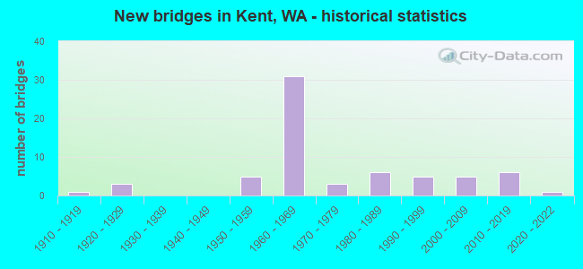
- New bridges - historical statistics
- 11910-1919
- 31920-1929
- 51950-1959
- 311960-1969
- 31970-1979
- 61980-1989
- 51990-1999
- 52000-2009
- 62010-2019
- 12020-2022
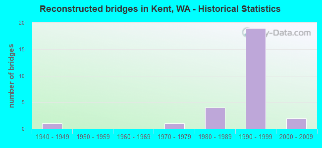
- Reconstructed bridges - Historical Statistics
- 11940-1949
- 01950-1959
- 01960-1969
- 11970-1979
- 41980-1989
- 191990-1999
- 22000-2009
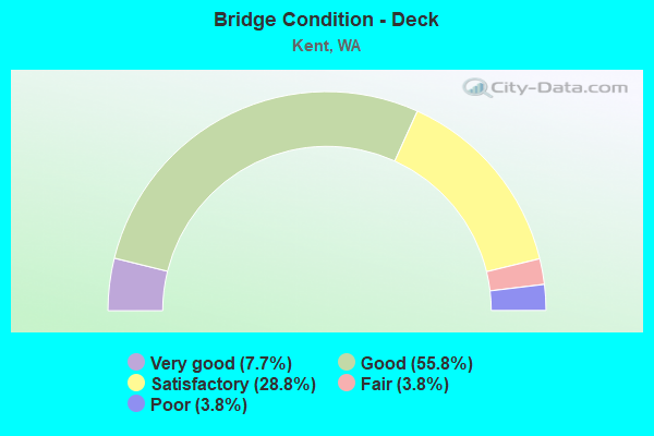
- Bridge Condition - Deck
- 7.7%Very good
- 55.8%Good
- 28.8%Satisfactory
- 3.8%Fair
- 3.8%Poor
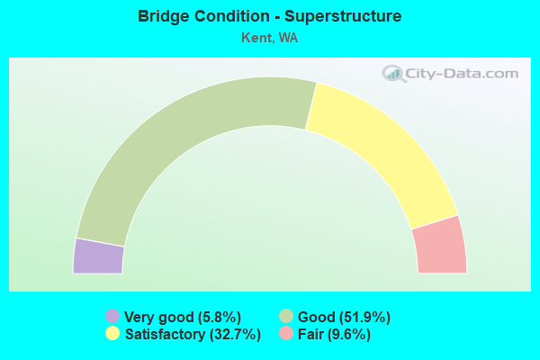
- Bridge Condition - Superstructure
- 5.8%Very good
- 51.9%Good
- 32.7%Satisfactory
- 9.6%Fair
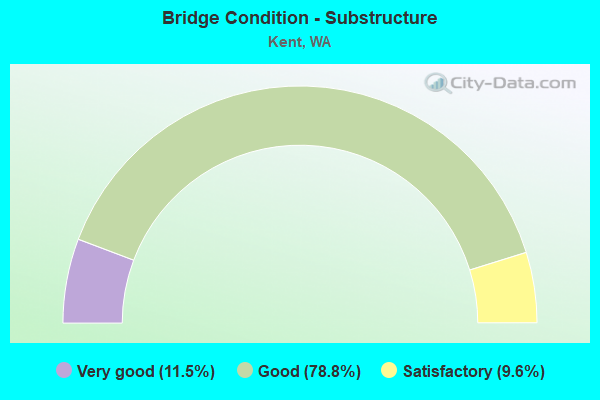
- Bridge Condition - Substructure
- 11.5%Very good
- 78.8%Good
- 9.6%Satisfactory
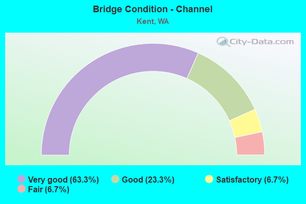
- Bridge Condition - Channel
- 63.3%Very good
- 23.3%Good
- 6.7%Satisfactory
- 6.7%Fair
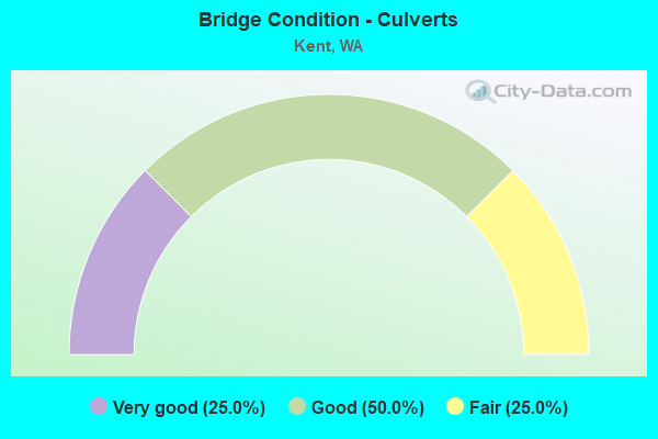
- Bridge Condition - Culverts
- 25.0%Very good
- 50.0%Good
- 25.0%Fair
Find on map >> Show street view
Structure Number: FS, Location: 0.7 MI S JCT SR-516 (Lat: 47.367694, Lng: -122.249278), Route carried "on" structure: County highway 450, Year Built: 1915, Status: Open, Structure Length: 1.07m (3.51ft), Average Daily Traffic: 24,100 (year 2018), Truck Traffic: 4%, Average Future Daily Traffic: 40,100 (year 2038), Features Intersected: MILL CR, Facility Carried by Structure: W VALLEY HWY
Minimum Vertical Clearance: 30+ m (98+ ft), Kilometerpoint: 0.001, Lanes on structure: 2, Owner: City or Municipal Highway Agency, Approaching Roadway Width: 9.1m (29.9ft), Material/Design: Concrete, Design/Construction: Culvert, Number Of Spans In Main Unit: 1, Length of Maximum Span: 9.1m (29.9ft), Curb-To-Curb Width: 8.0m (26.2ft), Out-to-Out Width: 8.6m (28.2ft)
Condition: Channel: Fair, Culverts: Fair, Operating Rating: 44.4 metric tons, Method Used To Determine Operating Rating: Load and Resistance Factor Rating (LRFR) rating reported by rating factor(RF) method using HL-93 loadings, Inventory Rating: 36.6 metric tons, Method Used To Determine Inventory Rating: Load and Resistance Factor Rating (LRFR) rating reported by rating factor(RF) method using HL-93 loadings, Structural Evaluation: Somewhat better than minimum adequacy, Deck Geometry: High priority of replacement, Waterway Adequacy: Equal to present desirable criteria, Approach Roadway Alignment: Equal to present desirable criteria, Length Of Structure Improvement: 1.37m (4.49ft), Designated Inspection Frequency: Every 24 months, Inspection Date: April 2020, Bridge Improvement Cost: $350,000, Roadway Improvement Cost: $250,000, Total Project Cost: $750,000 ( Estimate for 2014)
Find on map >> Show street view
Structure Number: QC, Location: 1.8 N JCT SR 516 (Lat: 47.412111, Lng: -122.221500), Route carried "on" structure: City street , Year Built: 1973, Year Reconstructed: 1992, Status: Open, Structure Length: 9.66m (31.69ft), Average Daily Traffic: 31,076 (year 2016), Truck Traffic: 5%, Average Future Daily Traffic: 48,668 (year 2038), Design Load: HS 20+Mod, Features Intersected: SR 167 & SPRINGBROOK CK, Facility Carried by Structure: S 212TH ST
Minimum Vertical Clearance: 30+ m (98+ ft), Kilometerpoint: 0.048, Lanes on structure: 5, Lanes under structure: 7, Base Highway Network: Yes, Owner: State Highway Agency, Approaching Roadway Width: 17.7m (58.1ft), Material/Design: Prestressed concrete, Design/Construction: Stringer/Multi-beam, Number Of Spans In Main Unit: 3, Length of Maximum Span: 31.4m (103.0ft), Curb or Sidewalk Widths: Left: 1.5m (4.9ft), Right: 0.0m, Curb-To-Curb Width: 18.6m (61.0ft), Out-to-Out Width: 20.9m (68.6ft)
Condition: Deck: Good, Superstructure: Satisfactory, Substructure: Good, Channel: Very good, Operating Rating: 85.3 metric tons, Method Used To Determine Operating Rating: Load Factor (LF), Inventory Rating: 49.9 metric tons, Method Used To Determine Inventory Rating: Load Factor (LF), Structural Evaluation: Equal to present minimum criteria, Deck Geometry: High priority of corrective action, Underclear: Somewhat better than minimum adequacy, Waterway Adequacy: Equal to present desirable criteria, Approach Roadway Alignment: Equal to present desirable criteria, Length Of Structure Improvement: 9.66m (31.69ft), Designated Inspection Frequency: Every 24 months, Inspection Date: March 2021, Bridge Improvement Cost: $3,804,000, Roadway Improvement Cost: $761,000, Total Project Cost: $7,608,000 ( Estimate for 2014), Deck Structure Type: Concrete Cast-file-Place, Wearing Surface/Protective System: Wearing Surface: Monolithic Concrete
Find on map >> Show street view
Structure Number: 4718A, Location: 0.1 MI N OF S 277TH ST (Lat: 47.356450, Lng: -122.249400), Route carried "on" structure: County highway 450, Year Built: 1954, Status: Posted for load, Structure Length: 1.83m (6.00ft), Average Daily Traffic: 20,000 (year 2018), Truck Traffic: 4%, Average Future Daily Traffic: 35,000 (year 2038), Design Load: HS 15, Features Intersected: MILL CR, Facility Carried by Structure: STATE ROUTE 181
Minimum Vertical Clearance: 30+ m (98+ ft), Kilometerpoint: 0.001, Lanes on structure: 2, Owner: City or Municipal Highway Agency, Approaching Roadway Width: 11.0m (36.1ft), Material/Design: Concrete continuous, Design/Construction: Slab, Number Of Spans In Main Unit: 3, Length of Maximum Span: 6.7m (22.0ft), Curb-To-Curb Width: 11.0m (36.1ft), Out-to-Out Width: 12.1m (39.7ft)
Condition: Deck: Satisfactory, Superstructure: Satisfactory, Substructure: Good, Channel: Good, Operating Rating: 19.4 metric tons, Method Used To Determine Operating Rating: Load and Resistance Factor Rating (LRFR) rating reported by rating factor(RF) method using HL-93 loadings, Inventory Rating: 14.9 metric tons, Method Used To Determine Inventory Rating: Load and Resistance Factor Rating (LRFR) rating reported by rating factor(RF) method using HL-93 loadings, Structural Evaluation: High priority of replacement, Deck Geometry: Meets minimum limits, Waterway Adequacy: Equal to present minimum criteria, Approach Roadway Alignment: Equal to present desirable criteria, Bridge Posting: Required (Relationship of Operating Rating to Maximum Legal Load: 20.0 - 29.9% below), Length Of Structure Improvement: 2.13m (6.99ft), Designated Inspection Frequency: Every 24 months, Inspection Date: April 2020, Bridge Improvement Cost: $1,064,000, Roadway Improvement Cost: $213,000, Total Project Cost: $2,128,000 ( Estimate for 2014), Deck Structure Type: Concrete Cast-file-Place, Wearing Surface/Protective System: Wearing Surface: Bituminous
Find on map >> Show street view
Structure Number: 6068C, Location: 6.2 E JCT SR 164 (Lat: 47.347886, Lng: -122.139206), Route carried "on" structure: State highway 18, Year Built: 1959, Year Reconstructed: 1993, Status: Open, Structure Length: 6.16m (20.21ft), Average Daily Traffic: 26,907 (year 2019), Truck Traffic: 13%, Average Future Daily Traffic: 37,992 (year 2039), Design Load: HS 20, Features Intersected: KENT-BLACK DIAMOND RD SE
Minimum Vertical Clearance: 30+ m (98+ ft), Kilometerpoint: 16.592, Lanes on structure: 2, Lanes under structure: 2, Base Highway Network: Yes, Owner: State Highway Agency, Approaching Roadway Width: 12.5m (41.0ft), Skew: 3 degrees, Material/Design: Prestressed concrete, Design/Construction: Stringer/Multi-beam, Number Of Spans In Main Unit: 3, Length of Maximum Span: 26.8m (87.9ft), Curb-To-Curb Width: 9.8m (32.2ft), Out-to-Out Width: 10.7m (35.1ft)
Condition: Deck: Good, Superstructure: Satisfactory, Substructure: Good, Operating Rating: 57.1 metric tons, Method Used To Determine Operating Rating: Load Factor (LF), Inventory Rating: 33.6 metric tons, Method Used To Determine Inventory Rating: Load Factor (LF), Structural Evaluation: Equal to present minimum criteria, Deck Geometry: Meets minimum limits, Underclear: Equal to present minimum criteria, Approach Roadway Alignment: Equal to present desirable criteria, Length Of Structure Improvement: 6.16m (20.21ft), Designated Inspection Frequency: Every 24 months, Inspection Date: March 2020, Bridge Improvement Cost: $1,737,000, Roadway Improvement Cost: $347,000, Total Project Cost: $3,474,000 ( Estimate for 2014), Deck Structure Type: Concrete Cast-file-Place, Wearing Surface/Protective System: Wearing Surface: Latex Concrete
Find on map >> Show street view
Structure Number: 6068D, Location: 6.7 E JCT SR 164 (Lat: 47.352889, Lng: -122.129917), Route carried "on" structure: State highway 18, Year Built: 1959, Year Reconstructed: 1979, Status: Open, Structure Length: 3.63m (11.91ft), Average Daily Traffic: 26,907 (year 2019), Truck Traffic: 13%, Average Future Daily Traffic: 37,992 (year 2039), Design Load: HS 20, Features Intersected: SOOS CR
Minimum Vertical Clearance: 30+ m (98+ ft), Kilometerpoint: 17.494, Lanes on structure: 2, Base Highway Network: Yes, Owner: State Highway Agency, Approaching Roadway Width: 13.4m (44.0ft), Skew: 2 degrees, Material/Design: Concrete continuous, Design/Construction: Slab, Number Of Spans In Main Unit: 3, Length of Maximum Span: 14.3m (46.9ft), Curb-To-Curb Width: 13.4m (44.0ft), Out-to-Out Width: 13.9m (45.6ft)
Condition: Deck: Good, Superstructure: Good, Substructure: Good, Channel: Very good, Operating Rating: 50.8 metric tons, Method Used To Determine Operating Rating: Load Factor (LF), Inventory Rating: 29.9 metric tons, Method Used To Determine Inventory Rating: Load Factor (LF), Structural Evaluation: Better than present minimum criteria, Deck Geometry: Superior to present desirable criteria, Waterway Adequacy: Equal to present desirable criteria, Approach Roadway Alignment: Equal to present desirable criteria, Length Of Structure Improvement: 3.63m (11.91ft), Designated Inspection Frequency: Every 24 months, Inspection Date: March 2020, Bridge Improvement Cost: $1,095,000, Roadway Improvement Cost: $219,000, Total Project Cost: $2,190,000 ( Estimate for 2014), Deck Structure Type: Concrete Cast-file-Place, Wearing Surface/Protective System: Wearing Surface: Bituminous
Find on map >> Show street view
Structure Number: 6186A, Location: 5.6 N JCT SR 18 (Lat: 47.369444, Lng: -122.293306), Route carried "on" structure: Interstate 5, Year Built: 1960, Year Reconstructed: 1991, Status: Open, Structure Length: 4.94m (16.21ft), Average Daily Traffic: 105,986 (year 2019), Truck Traffic: 8%, Average Future Daily Traffic: 149,652 (year 2039), Design Load: HS 20, Features Intersected: S 259TH PL
Minimum Vertical Clearance: 30+ m (98+ ft), Kilometerpoint: 237.604, Lanes on structure: 5, Lanes under structure: 2, Base Highway Network: Yes, Owner: State Highway Agency, Approaching Roadway Width: 18.9m (62.0ft), Material/Design: Concrete continuous, Design/Construction: Slab, Number Of Spans In Main Unit: 3, Length of Maximum Span: 19.5m (64.0ft), Curb-To-Curb Width: 19.2m (63.0ft), Out-to-Out Width: 20.7m (67.9ft)
Condition: Deck: Very good, Superstructure: Good, Substructure: Good, Operating Rating: 51.7 metric tons, Method Used To Determine Operating Rating: Load Factor (LF), Inventory Rating: 30.8 metric tons, Method Used To Determine Inventory Rating: Load Factor (LF), Structural Evaluation: Better than present minimum criteria, Deck Geometry: High priority of replacement, Underclear: Somewhat better than minimum adequacy, Approach Roadway Alignment: Equal to present desirable criteria, Length Of Structure Improvement: 4.94m (16.21ft), Designated Inspection Frequency: Every 48 months, Inspection Date: October 2018, Bridge Improvement Cost: $2,074,000, Roadway Improvement Cost: $415,000, Total Project Cost: $4,147,000 ( Estimate for 2014), Deck Structure Type: Concrete Cast-file-Place, Wearing Surface/Protective System: Wearing Surface: Bituminous, Membrane: Preformed Fabric
Find on map >> Show street view
Structure Number: 6186B, Location: 5.6 N JCT SR 18 (Lat: 47.369500, Lng: -122.293806), Route carried "on" structure: Interstate 5, Year Built: 1960, Year Reconstructed: 2002, Status: Open, Structure Length: 4.94m (16.21ft), Average Daily Traffic: 105,986 (year 2019), Truck Traffic: 8%, Average Future Daily Traffic: 149,652 (year 2039), Design Load: HS 20, Features Intersected: S 259TH PL
Minimum Vertical Clearance: 30+ m (98+ ft), Kilometerpoint: 237.604, Lanes on structure: 5, Lanes under structure: 2, Base Highway Network: Yes, Owner: State Highway Agency, Approaching Roadway Width: 23.8m (78.1ft), Material/Design: Concrete continuous, Design/Construction: Slab, Number Of Spans In Main Unit: 3, Length of Maximum Span: 19.5m (64.0ft), Curb-To-Curb Width: 24.0m (78.7ft), Out-to-Out Width: 28.1m (92.2ft)
Condition: Deck: Satisfactory, Superstructure: Satisfactory, Substructure: Good, Operating Rating: 49.0 metric tons, Method Used To Determine Operating Rating: Load Factor (LF), Inventory Rating: 29.0 metric tons, Method Used To Determine Inventory Rating: Load Factor (LF), Structural Evaluation: Equal to present minimum criteria, Deck Geometry: Equal to present minimum criteria, Underclear: High priority of corrective action, Approach Roadway Alignment: Equal to present desirable criteria, Length Of Structure Improvement: 4.94m (16.21ft), Designated Inspection Frequency: Every 48 months, Inspection Date: October 2018, Bridge Improvement Cost: $2,592,000, Roadway Improvement Cost: $518,000, Total Project Cost: $5,184,000 ( Estimate for 2014), Deck Structure Type: Concrete Cast-file-Place, Wearing Surface/Protective System: Wearing Surface: Bituminous, Membrane: Preformed Fabric
Find on map >> Show street view
Structure Number: 6820A, Location: 7.2 N JCT SR 18 (Lat: 47.391250, Lng: -122.290694), Route carried "on" structure: Interstate 5, Year Built: 1962, Year Reconstructed: 1991, Status: Open, Structure Length: 8.20m (26.90ft), Average Daily Traffic: 105,986 (year 2019), Truck Traffic: 8%, Average Future Daily Traffic: 149,652 (year 2039), Design Load: HS 20, Features Intersected: SR 516
Minimum Vertical Clearance: 30+ m (98+ ft), Kilometerpoint: 240.066, Lanes on structure: 6, Lanes under structure: 4, Base Highway Network: Yes, Owner: State Highway Agency, Approaching Roadway Width: 27.4m (89.9ft), Skew: 3 degrees, Material/Design: Prestressed concrete, Design/Construction: Stringer/Multi-beam, Number Of Spans In Main Unit: 4, Length of Maximum Span: 21.3m (69.9ft), Curb-To-Curb Width: 25.6m (84.0ft), Out-to-Out Width: 27.4m (89.9ft)
Condition: Deck: Satisfactory, Superstructure: Good, Substructure: Satisfactory, Operating Rating: 81.6 metric tons, Method Used To Determine Operating Rating: Load Factor (LF), Inventory Rating: 49.0 metric tons, Method Used To Determine Inventory Rating: Load Factor (LF), Structural Evaluation: Equal to present minimum criteria, Deck Geometry: Meets minimum limits, Underclear: Somewhat better than minimum adequacy, Approach Roadway Alignment: Equal to present desirable criteria, Length Of Structure Improvement: 8.20m (26.90ft), Designated Inspection Frequency: Every 48 months, Inspection Date: October 2018, Bridge Improvement Cost: $4,950,000, Roadway Improvement Cost: $990,000, Total Project Cost: $9,899,000 ( Estimate for 2014), Deck Structure Type: Concrete Cast-file-Place, Wearing Surface/Protective System: Wearing Surface: Monolithic Concrete
Find on map >> Show street view
Structure Number: 6820B, Location: 7.2 N JCT SR 18 (Lat: 47.391389, Lng: -122.291056), Route carried "on" structure: Interstate 5, Year Built: 1962, Year Reconstructed: 2002, Status: Open, Structure Length: 7.89m (25.89ft), Average Daily Traffic: 105,986 (year 2019), Truck Traffic: 8%, Average Future Daily Traffic: 149,652 (year 2039), Design Load: HS 20, Features Intersected: SR 516
Minimum Vertical Clearance: 30+ m (98+ ft), Kilometerpoint: 240.066, Lanes on structure: 5, Lanes under structure: 4, Base Highway Network: Yes, Owner: State Highway Agency, Approaching Roadway Width: 22.9m (75.1ft), Skew: 3 degrees, Material/Design: Prestressed concrete, Design/Construction: Stringer/Multi-beam, Number Of Spans In Main Unit: 4, Length of Maximum Span: 21.3m (69.9ft), Curb-To-Curb Width: 21.7m (71.2ft), Out-to-Out Width: 22.0m (72.2ft)
Condition: Deck: Satisfactory, Superstructure: Satisfactory, Substructure: Satisfactory, Operating Rating: 72.6 metric tons, Method Used To Determine Operating Rating: Load Factor (LF), Inventory Rating: 43.5 metric tons, Method Used To Determine Inventory Rating: Load Factor (LF), Structural Evaluation: Equal to present minimum criteria, Deck Geometry: Meets minimum limits, Underclear: Better than present minimum criteria, Approach Roadway Alignment: Equal to present desirable criteria, Length Of Structure Improvement: 7.89m (25.89ft), Designated Inspection Frequency: Every 48 months, Inspection Date: October 2018, Bridge Improvement Cost: $3,988,000, Roadway Improvement Cost: $798,000, Total Project Cost: $7,977,000 ( Estimate for 2014), Deck Structure Type: Concrete Cast-file-Place, Wearing Surface/Protective System: Wearing Surface: Monolithic Concrete
Find on map >> Show street view
Structure Number: 7085A, Location: 2.0 N JCT SR 516 (Lat: 47.415500, Lng: -122.221111), Route carried "on" structure: City street , Year Built: 1963, Status: Open, Structure Length: 7.50m (24.61ft), Average Daily Traffic: 5,460 (year 2002), Truck Traffic: 5%, Average Future Daily Traffic: 7,316 (year 2036), Design Load: HS 20, Features Intersected: SR 167 & SPRINGBROOK CR, Facility Carried by Structure: S 208TH ST
Minimum Vertical Clearance: 30+ m (98+ ft), Kilometerpoint: 0.001, Lanes on structure: 2, Lanes under structure: 6, Owner: State Highway Agency, Approaching Roadway Width: 9.8m (32.2ft), Material/Design: Prestressed concrete, Design/Construction: Stringer/Multi-beam, Number Of Spans In Main Unit: 4, Length of Maximum Span: 21.3m (69.9ft), Curb or Sidewalk Widths: Left: 1.2m (3.9ft), Right: 0.6m (2.0ft), Curb-To-Curb Width: 7.9m (25.9ft), Out-to-Out Width: 10.2m (33.5ft)
Condition: Deck: Good, Superstructure: Good, Substructure: Good, Channel: Good, Operating Rating: 85.3 metric tons, Method Used To Determine Operating Rating: Load Factor (LF), Inventory Rating: 49.9 metric tons, Method Used To Determine Inventory Rating: Load Factor (LF), Structural Evaluation: Better than present minimum criteria, Deck Geometry: High priority of corrective action, Underclear: Meets minimum limits, Waterway Adequacy: Equal to present desirable criteria, Approach Roadway Alignment: Equal to present desirable criteria, Length Of Structure Improvement: 7.50m (24.61ft), Designated Inspection Frequency: Every 24 months, Inspection Date: Febuary 2021, Bridge Improvement Cost: $1,673,000, Roadway Improvement Cost: $335,000, Total Project Cost: $3,346,000 ( Estimate for 2014), Deck Structure Type: Concrete Cast-file-Place, Wearing Surface/Protective System: Wearing Surface: Monolithic Concrete
Find on map >> Show street view
Structure Number: 8114A, Location: 4.3 N JCT SR 18 (Lat: 47.369667, Lng: -122.244306), Route carried "on" structure: State highway 167, Year Built: 1967, Year Reconstructed: 1998, Status: Open, Structure Length: 7.35m (24.11ft), Average Daily Traffic: 69,129 (year 2019), Truck Traffic: 10%, Average Future Daily Traffic: 97,610 (year 2039), Design Load: HS 20+Mod, Features Intersected: GREEN RIVER
Minimum Vertical Clearance: 30+ m (98+ ft), Kilometerpoint: 30.642, Lanes on structure: 3, Base Highway Network: Yes, Owner: State Highway Agency, Approaching Roadway Width: 16.5m (54.1ft), Material/Design: Prestressed concrete, Design/Construction: Stringer/Multi-beam, Number Of Spans In Main Unit: 1, Number Of Approach Spans: 2, Length of Maximum Span: 45.7m (149.9ft), Curb-To-Curb Width: 16.5m (54.1ft), Out-to-Out Width: 17.4m (57.1ft)
Condition: Deck: Good, Superstructure: Satisfactory, Substructure: Good, Channel: Good, Operating Rating: 47.2 metric tons, Method Used To Determine Operating Rating: Load Factor (LF), Inventory Rating: 28.1 metric tons, Method Used To Determine Inventory Rating: Load Factor (LF), Structural Evaluation: Equal to present minimum criteria, Deck Geometry: Equal to present minimum criteria, Waterway Adequacy: Equal to present desirable criteria, Approach Roadway Alignment: Equal to present desirable criteria, Length Of Structure Improvement: 7.35m (24.11ft), Designated Inspection Frequency: Every 24 months, Inspection Date: April 2021, Bridge Improvement Cost: $2,699,000, Roadway Improvement Cost: $540,000, Total Project Cost: $5,398,000 ( Estimate for 2014), Deck Structure Type: Concrete Cast-file-Place, Wearing Surface/Protective System: Wearing Surface: Latex Concrete
Find on map >> Show street view
Structure Number: 8114B, Location: 4.3 N JCT SR 18 (Lat: 47.369694, Lng: -122.244583), Route carried "on" structure: State highway 167, Year Built: 1967, Year Reconstructed: 1998, Status: Open, Structure Length: 7.35m (24.11ft), Average Daily Traffic: 69,129 (year 2019), Truck Traffic: 10%, Average Future Daily Traffic: 97,610 (year 2039), Design Load: HS 20+Mod, Features Intersected: GREEN RIVER
Minimum Vertical Clearance: 30+ m (98+ ft), Kilometerpoint: 30.642, Lanes on structure: 3, Base Highway Network: Yes, Owner: State Highway Agency, Approaching Roadway Width: 16.5m (54.1ft), Material/Design: Prestressed concrete, Design/Construction: Stringer/Multi-beam, Number Of Spans In Main Unit: 1, Number Of Approach Spans: 2, Length of Maximum Span: 45.7m (149.9ft), Curb-To-Curb Width: 16.5m (54.1ft), Out-to-Out Width: 17.4m (57.1ft)
Condition: Deck: Satisfactory, Superstructure: Satisfactory, Substructure: Good, Channel: Good, Operating Rating: 47.2 metric tons, Method Used To Determine Operating Rating: Load Factor (LF), Inventory Rating: 28.1 metric tons, Method Used To Determine Inventory Rating: Load Factor (LF), Structural Evaluation: Equal to present minimum criteria, Deck Geometry: Equal to present minimum criteria, Waterway Adequacy: Equal to present desirable criteria, Approach Roadway Alignment: Equal to present desirable criteria, Length Of Structure Improvement: 7.35m (24.11ft), Designated Inspection Frequency: Every 24 months, Inspection Date: April 2021, Bridge Improvement Cost: $2,699,000, Roadway Improvement Cost: $540,000, Total Project Cost: $5,398,000 ( Estimate for 2014), Deck Structure Type: Concrete Cast-file-Place, Wearing Surface/Protective System: Wearing Surface: Monolithic Concrete
Find on map >> Show street view
Structure Number: 8114C, Location: 4.9 N JCT SR 18 (Lat: 47.377778, Lng: -122.244444), Route carried "on" structure: State highway 167, Year Built: 1967, Year Reconstructed: 1997, Status: Open, Structure Length: 5.79m (19.00ft), Average Daily Traffic: 54,241 (year 2019), Truck Traffic: 10%, Average Future Daily Traffic: 76,588 (year 2039), Design Load: HS 20+Mod, Features Intersected: SR 516
Minimum Vertical Clearance: 30+ m (98+ ft), Kilometerpoint: 31.543, Lanes on structure: 3, Lanes under structure: 4, Base Highway Network: Yes, Owner: State Highway Agency, Approaching Roadway Width: 16.5m (54.1ft), Material/Design: Prestressed concrete, Design/Construction: Stringer/Multi-beam, Number Of Spans In Main Unit: 2, Length of Maximum Span: 29.6m (97.1ft), Curb-To-Curb Width: 16.5m (54.1ft), Out-to-Out Width: 17.2m (56.4ft)
Condition: Deck: Good, Superstructure: Satisfactory, Substructure: Good, Operating Rating: 73.5 metric tons, Method Used To Determine Operating Rating: Load Factor (LF), Inventory Rating: 39.0 metric tons, Method Used To Determine Inventory Rating: Load Factor (LF), Structural Evaluation: Equal to present minimum criteria, Deck Geometry: Equal to present minimum criteria, Underclear: Meets minimum limits, Approach Roadway Alignment: Equal to present desirable criteria, Length Of Structure Improvement: 5.79m (19.00ft), Designated Inspection Frequency: Every 24 months, Inspection Date: March 2021, Bridge Improvement Cost: $2,128,000, Roadway Improvement Cost: $426,000, Total Project Cost: $4,256,000 ( Estimate for 2014), Deck Structure Type: Concrete Cast-file-Place, Wearing Surface/Protective System: Wearing Surface: Monolithic Concrete
Find on map >> Show street view
Structure Number: 8114D, Location: 4.9 N JCT SR 18 (Lat: 47.377750, Lng: -122.244639), Route carried "on" structure: State highway 167, Year Built: 1967, Year Reconstructed: 1997, Status: Open, Structure Length: 5.79m (19.00ft), Average Daily Traffic: 54,241 (year 2019), Truck Traffic: 10%, Average Future Daily Traffic: 76,588 (year 2039), Design Load: HS 20+Mod, Features Intersected: SR 516
Minimum Vertical Clearance: 30+ m (98+ ft), Kilometerpoint: 31.543, Lanes on structure: 3, Lanes under structure: 4, Base Highway Network: Yes, Owner: State Highway Agency, Approaching Roadway Width: 16.5m (54.1ft), Material/Design: Prestressed concrete, Design/Construction: Stringer/Multi-beam, Number Of Spans In Main Unit: 2, Length of Maximum Span: 29.6m (97.1ft), Curb-To-Curb Width: 16.5m (54.1ft), Out-to-Out Width: 17.2m (56.4ft)
Condition: Deck: Satisfactory, Superstructure: Good, Substructure: Good, Operating Rating: 73.5 metric tons, Method Used To Determine Operating Rating: Load Factor (LF), Inventory Rating: 39.0 metric tons, Method Used To Determine Inventory Rating: Load Factor (LF), Structural Evaluation: Better than present minimum criteria, Deck Geometry: Equal to present minimum criteria, Underclear: Somewhat better than minimum adequacy, Approach Roadway Alignment: Equal to present desirable criteria, Length Of Structure Improvement: 5.79m (19.00ft), Designated Inspection Frequency: Every 24 months, Inspection Date: March 2021, Bridge Improvement Cost: $2,128,000, Roadway Improvement Cost: $426,000, Total Project Cost: $4,256,000 ( Estimate for 2014), Deck Structure Type: Concrete Cast-file-Place, Wearing Surface/Protective System: Wearing Surface: Monolithic Concrete, Deck Protection: Epoxy Coated Reinforcing
Find on map >> Show street view
Structure Number: 8114E, Location: 0.2 N JCT SR 516 (Lat: 47.381222, Lng: -122.244250), Route carried "on" structure: State highway 167, Year Built: 1967, Year Reconstructed: 2007, Status: Open, Structure Length: 4.82m (15.81ft), Average Daily Traffic: 54,241 (year 2019), Truck Traffic: 10%, Average Future Daily Traffic: 76,588 (year 2039), Design Load: HS 20+Mod, Features Intersected: MEEKER ST
Minimum Vertical Clearance: 30+ m (98+ ft), Kilometerpoint: 31.913, Lanes on structure: 4, Lanes under structure: 4, Base Highway Network: Yes, Owner: State Highway Agency, Approaching Roadway Width: 25.6m (84.0ft), Material/Design: Prestressed concrete, Design/Construction: Stringer/Multi-beam, Number Of Spans In Main Unit: 3, Length of Maximum Span: 20.4m (66.9ft), Curb-To-Curb Width: 24.7m (81.0ft), Out-to-Out Width: 26.5m (86.9ft)
Condition: Deck: Very good, Superstructure: Satisfactory, Substructure: Good, Operating Rating: 65.3 metric tons, Method Used To Determine Operating Rating: Load Factor (LF), Inventory Rating: 39.0 metric tons, Method Used To Determine Inventory Rating: Load Factor (LF), Structural Evaluation: Equal to present minimum criteria, Deck Geometry: Superior to present desirable criteria, Underclear: Meets minimum limits, Approach Roadway Alignment: Equal to present desirable criteria, Length Of Structure Improvement: 4.82m (15.81ft), Designated Inspection Frequency: Every 24 months, Inspection Date: March 2021, Bridge Improvement Cost: $2,718,000, Roadway Improvement Cost: $544,000, Total Project Cost: $5,435,000 ( Estimate for 2014), Deck Structure Type: Concrete Cast-file-Place, Wearing Surface/Protective System: Wearing Surface: Latex Concrete
Find on map >> Show street view
Structure Number: 8114F, Location: 0.2 N JCT SR 516 (Lat: 47.381194, Lng: -122.244583), Route carried "on" structure: State highway 167, Year Built: 1967, Year Reconstructed: 1998, Status: Open, Structure Length: 4.82m (15.81ft), Average Daily Traffic: 54,241 (year 2019), Truck Traffic: 10%, Average Future Daily Traffic: 76,588 (year 2039), Design Load: HS 20+Mod, Features Intersected: MEEKER ST
Minimum Vertical Clearance: 30+ m (98+ ft), Kilometerpoint: 31.913, Lanes on structure: 4, Lanes under structure: 4, Base Highway Network: Yes, Owner: State Highway Agency, Approaching Roadway Width: 11.6m (38.1ft), Material/Design: Prestressed concrete, Design/Construction: Stringer/Multi-beam, Number Of Spans In Main Unit: 3, Length of Maximum Span: 19.5m (64.0ft), Curb or Sidewalk Widths: Left: 0.2m (0.7ft), Right: 0.0m, Curb-To-Curb Width: 18.2m (59.7ft), Out-to-Out Width: 18.8m (61.7ft)
Condition: Deck: Satisfactory, Superstructure: Satisfactory, Substructure: Good, Operating Rating: 65.3 metric tons, Method Used To Determine Operating Rating: Load Factor (LF), Inventory Rating: 39.0 metric tons, Method Used To Determine Inventory Rating: Load Factor (LF), Structural Evaluation: Equal to present minimum criteria, Deck Geometry: Meets minimum limits, Underclear: Somewhat better than minimum adequacy, Approach Roadway Alignment: Equal to present desirable criteria, Length Of Structure Improvement: 4.82m (15.81ft), Designated Inspection Frequency: Every 24 months, Inspection Date: March 2021, Bridge Improvement Cost: $1,264,000, Roadway Improvement Cost: $253,000, Total Project Cost: $2,528,000 ( Estimate for 2014), Deck Structure Type: Concrete Cast-file-Place, Wearing Surface/Protective System: Wearing Surface: Monolithic Concrete, Deck Protection: Epoxy Coated Reinforcing
Find on map >> Show street view
Structure Number: 8114G, Location: 0.6 N JCT SR 516 (Lat: 47.386472, Lng: -122.243972), Route carried "on" structure: State highway 167, Year Built: 1967, Year Reconstructed: 1998, Status: Open, Structure Length: 5.82m (19.09ft), Average Daily Traffic: 60,643 (year 2019), Truck Traffic: 10%, Average Future Daily Traffic: 85,627 (year 2039), Design Load: HS 20+Mod, Features Intersected: JAMES ST
Minimum Vertical Clearance: 30+ m (98+ ft), Kilometerpoint: 32.509, Lanes on structure: 3, Lanes under structure: 4, Base Highway Network: Yes, Owner: State Highway Agency, Approaching Roadway Width: 11.6m (38.1ft), Skew: 9 degrees, Material/Design: Prestressed concrete, Design/Construction: Stringer/Multi-beam, Number Of Spans In Main Unit: 3, Length of Maximum Span: 23.8m (78.1ft), Curb or Sidewalk Widths: Left: 0.2m (0.7ft), Right: 0.2m (0.7ft), Curb-To-Curb Width: 16.5m (54.1ft), Out-to-Out Width: 17.0m (55.8ft)
Condition: Deck: Satisfactory, Superstructure: Good, Substructure: Good, Operating Rating: 65.3 metric tons, Method Used To Determine Operating Rating: Load Factor (LF), Inventory Rating: 39.0 metric tons, Method Used To Determine Inventory Rating: Load Factor (LF), Structural Evaluation: Better than present minimum criteria, Deck Geometry: Equal to present minimum criteria, Underclear: Equal to present desirable criteria, Approach Roadway Alignment: Equal to present desirable criteria, Length Of Structure Improvement: 5.82m (19.09ft), Designated Inspection Frequency: Every 24 months, Inspection Date: December 2020, Bridge Improvement Cost: $1,528,000, Roadway Improvement Cost: $306,000, Total Project Cost: $3,056,000 ( Estimate for 2014), Deck Structure Type: Concrete Cast-file-Place, Wearing Surface/Protective System: Wearing Surface: Monolithic Concrete
Find on map >> Show street view
Structure Number: 8114H, Location: 0.6 N JCT SR 516 (Lat: 47.386717, Lng: -122.244200), Route carried "on" structure: State highway 167, Year Built: 1967, Year Reconstructed: 1998, Status: Open, Structure Length: 5.82m (19.09ft), Average Daily Traffic: 60,643 (year 2019), Truck Traffic: 10%, Average Future Daily Traffic: 85,627 (year 2039), Design Load: HS 20+Mod, Features Intersected: JAMES ST
Minimum Vertical Clearance: 30+ m (98+ ft), Kilometerpoint: 32.509, Lanes on structure: 3, Lanes under structure: 4, Base Highway Network: Yes, Owner: State Highway Agency, Approaching Roadway Width: 11.6m (38.1ft), Skew: 9 degrees, Material/Design: Prestressed concrete, Design/Construction: Stringer/Multi-beam, Number Of Spans In Main Unit: 3, Length of Maximum Span: 23.8m (78.1ft), Curb or Sidewalk Widths: Left: 0.2m (0.7ft), Right: 0.2m (0.7ft), Curb-To-Curb Width: 16.5m (54.1ft), Out-to-Out Width: 17.0m (55.8ft)
Condition: Deck: Good, Superstructure: Good, Substructure: Good, Operating Rating: 65.3 metric tons, Method Used To Determine Operating Rating: Load Factor (LF), Inventory Rating: 39.0 metric tons, Method Used To Determine Inventory Rating: Load Factor (LF), Structural Evaluation: Better than present minimum criteria, Deck Geometry: Equal to present minimum criteria, Underclear: Somewhat better than minimum adequacy, Approach Roadway Alignment: Equal to present desirable criteria, Length Of Structure Improvement: 5.82m (19.09ft), Designated Inspection Frequency: Every 48 months, Inspection Date: December 2018, Bridge Improvement Cost: $1,528,000, Roadway Improvement Cost: $306,000, Total Project Cost: $3,056,000 ( Estimate for 2014), Deck Structure Type: Concrete Cast-file-Place, Wearing Surface/Protective System: Wearing Surface: Monolithic Concrete
Find on map >> Show street view
Structure Number: 8114I, Location: 1.7 N JCT SR 516 (Lat: 47.398250, Lng: -122.228389), Route carried "on" structure: State highway 167, Year Built: 1967, Year Reconstructed: 1998, Status: Open, Structure Length: 6.98m (22.90ft), Average Daily Traffic: 53,077 (year 2019), Truck Traffic: 10%, Average Future Daily Traffic: 74,944 (year 2039), Design Load: HS 20+Mod, Features Intersected: 84TH AVE SOUTH
Minimum Vertical Clearance: 30+ m (98+ ft), Kilometerpoint: 34.295, Lanes on structure: 3, Lanes under structure: 5, Base Highway Network: Yes, Owner: State Highway Agency, Approaching Roadway Width: 16.5m (54.1ft), Skew: 4 degrees, Material/Design: Prestressed concrete, Design/Construction: Stringer/Multi-beam, Number Of Spans In Main Unit: 3, Length of Maximum Span: 29.0m (95.1ft), Curb or Sidewalk Widths: Left: 0.2m (0.7ft), Right: 0.2m (0.7ft), Curb-To-Curb Width: 16.5m (54.1ft), Out-to-Out Width: 17.0m (55.8ft)
Condition: Deck: Satisfactory, Superstructure: Good, Substructure: Good, Operating Rating: 62.6 metric tons, Method Used To Determine Operating Rating: Load Factor (LF), Inventory Rating: 36.3 metric tons, Method Used To Determine Inventory Rating: Load Factor (LF), Structural Evaluation: Better than present minimum criteria, Deck Geometry: Equal to present minimum criteria, Underclear: Meets minimum limits, Approach Roadway Alignment: Equal to present desirable criteria, Length Of Structure Improvement: 6.98m (22.90ft), Designated Inspection Frequency: Every 48 months, Inspection Date: July 2018, Bridge Improvement Cost: $2,565,000, Roadway Improvement Cost: $513,000, Total Project Cost: $5,130,000 ( Estimate for 2014), Deck Structure Type: Concrete Cast-file-Place, Wearing Surface/Protective System: Wearing Surface: Monolithic Concrete
Find on map >> Show street view
Structure Number: 8114J, Location: 1.7 N JCT SR 516 (Lat: 47.398736, Lng: -122.228017), Route carried "on" structure: State highway 167, Year Built: 1967, Year Reconstructed: 1998, Status: Open, Structure Length: 6.98m (22.90ft), Average Daily Traffic: 53,077 (year 2019), Truck Traffic: 10%, Average Future Daily Traffic: 74,944 (year 2039), Design Load: HS 20+Mod, Features Intersected: 84TH AVE SOUTH
Minimum Vertical Clearance: 30+ m (98+ ft), Kilometerpoint: 34.295, Lanes on structure: 3, Lanes under structure: 5, Base Highway Network: Yes, Owner: State Highway Agency, Approaching Roadway Width: 16.5m (54.1ft), Skew: 4 degrees, Material/Design: Prestressed concrete, Design/Construction: Stringer/Multi-beam, Number Of Spans In Main Unit: 3, Length of Maximum Span: 29.0m (95.1ft), Curb-To-Curb Width: 16.5m (54.1ft), Out-to-Out Width: 17.0m (55.8ft)
Condition: Deck: Satisfactory, Superstructure: Good, Substructure: Good, Operating Rating: 59.0 metric tons, Method Used To Determine Operating Rating: Load Factor (LF), Inventory Rating: 31.7 metric tons, Method Used To Determine Inventory Rating: Load Factor (LF), Structural Evaluation: Better than present minimum criteria, Deck Geometry: Equal to present minimum criteria, Underclear: Meets minimum limits, Approach Roadway Alignment: Equal to present desirable criteria, Length Of Structure Improvement: 6.98m (22.90ft), Designated Inspection Frequency: Every 48 months, Inspection Date: July 2018, Bridge Improvement Cost: $2,565,000, Roadway Improvement Cost: $513,000, Total Project Cost: $5,130,000 ( Estimate for 2014), Deck Structure Type: Concrete Cast-file-Place, Wearing Surface/Protective System: Wearing Surface: Latex Concrete
Find on map >> Show street view
Structure Number: 8175A, Location: 0.8 N JCT SR 516 (Lat: 47.388861, Lng: -122.242111), Route carried "on" structure: State highway 167, Year Built: 1967, Year Reconstructed: 1998, Status: Open, Structure Length: 10.61m (34.81ft), Average Daily Traffic: 60,643 (year 2019), Truck Traffic: 10%, Average Future Daily Traffic: 85,627 (year 2039), Design Load: HS 20+Mod, Features Intersected: RAILROAD & PED TRAIL
Minimum Vertical Clearance: 30+ m (98+ ft), Kilometerpoint: 32.831, Lanes on structure: 3, Base Highway Network: Yes, Owner: State Highway Agency, Approaching Roadway Width: 17.1m (56.1ft), Skew: 4 degrees, Material/Design: Prestressed concrete, Design/Construction: Stringer/Multi-beam, Number Of Spans In Main Unit: 3, Length of Maximum Span: 36.6m (120.1ft), Curb-To-Curb Width: 16.5m (54.1ft), Out-to-Out Width: 17.0m (55.8ft)
Condition: Deck: Good, Superstructure: Good, Substructure: Good, Operating Rating: 20.4 metric tons, Method Used To Determine Operating Rating: Load and Resistance Factor Rating (LRFR) rating reported by rating factor(RF) method using HL-93 loadings, Inventory Rating: 13.3 metric tons, Method Used To Determine Inventory Rating: Load and Resistance Factor Rating (LRFR) rating reported by rating factor(RF) method using HL-93 loadings, Structural Evaluation: High priority of corrective action, Deck Geometry: Equal to present minimum criteria, Underclear: Superior to present desirable criteria, Approach Roadway Alignment: Equal to present desirable criteria, Length Of Structure Improvement: 10.61m (34.81ft), Designated Inspection Frequency: Every 48 months, Inspection Date: July 2018, Bridge Improvement Cost: $4,037,000, Roadway Improvement Cost: $807,000, Total Project Cost: $8,074,000 ( Estimate for 2014), Deck Structure Type: Concrete Cast-file-Place, Wearing Surface/Protective System: Wearing Surface: Latex Concrete
Find on map >> Show street view
Structure Number: 8175B, Location: 0.8 N JCT SR 516 (Lat: 47.389083, Lng: -122.242139), Route carried "on" structure: State highway 167, Year Built: 1967, Year Reconstructed: 1998, Status: Open, Structure Length: 10.97m (35.99ft), Average Daily Traffic: 60,643 (year 2019), Truck Traffic: 10%, Average Future Daily Traffic: 85,627 (year 2039), Design Load: HS 20+Mod, Features Intersected: CMSTPP RR
Minimum Vertical Clearance: 30+ m (98+ ft), Kilometerpoint: 32.831, Lanes on structure: 3, Base Highway Network: Yes, Owner: State Highway Agency, Approaching Roadway Width: 11.6m (38.1ft), Skew: 4 degrees, Material/Design: Prestressed concrete, Design/Construction: Stringer/Multi-beam, Number Of Spans In Main Unit: 3, Length of Maximum Span: 36.6m (120.1ft), Curb-To-Curb Width: 15.2m (49.9ft), Out-to-Out Width: 15.8m (51.8ft)
Condition: Deck: Poor, Superstructure: Good, Substructure: Good, Operating Rating: 68.0 metric tons, Method Used To Determine Operating Rating: Load Factor (LF), Inventory Rating: 39.9 metric tons, Method Used To Determine Inventory Rating: Load Factor (LF), Structural Evaluation: Better than present minimum criteria, Deck Geometry: Meets minimum limits, Underclear: Better than present minimum criteria, Approach Roadway Alignment: Equal to present desirable criteria, Length Of Structure Improvement: 10.97m (35.99ft), Designated Inspection Frequency: Every 24 months, Inspection Date: September 2020, Bridge Improvement Cost: $2,880,000, Roadway Improvement Cost: $576,000, Total Project Cost: $5,760,000 ( Estimate for 2014), Deck Structure Type: Concrete Cast-file-Place, Wearing Surface/Protective System: Wearing Surface: Monolithic Concrete
Find on map >> Show street view
Structure Number: 8175C, Location: 1.1 N JCT SR 516 (Lat: 47.392228, Lng: -122.237303), Route carried "on" structure: State highway 167, Year Built: 1967, Status: Open, Structure Length: 7.50m (24.61ft), Average Daily Traffic: 60,643 (year 2019), Truck Traffic: 10%, Average Future Daily Traffic: 85,627 (year 2039), Design Load: HS 20+Mod, Features Intersected: 4TH AVE N
Minimum Vertical Clearance: 30+ m (98+ ft), Kilometerpoint: 33.313, Lanes on structure: 3, Lanes under structure: 4, Base Highway Network: Yes, Owner: State Highway Agency, Approaching Roadway Width: 16.5m (54.1ft), Skew: 4 degrees, Material/Design: Prestressed concrete continuous, Design/Construction: Stringer/Multi-beam, Number Of Spans In Main Unit: 3, Length of Maximum Span: 31.4m (103.0ft), Curb-To-Curb Width: 16.5m (54.1ft), Out-to-Out Width: 17.3m (56.8ft)
Condition: Deck: Good, Superstructure: Good, Substructure: Good, Operating Rating: 49.9 metric tons, Method Used To Determine Operating Rating: Load Factor (LF), Inventory Rating: 29.9 metric tons, Method Used To Determine Inventory Rating: Load Factor (LF), Structural Evaluation: Better than present minimum criteria, Deck Geometry: Equal to present minimum criteria, Underclear: Equal to present minimum criteria, Approach Roadway Alignment: Equal to present desirable criteria, Length Of Structure Improvement: 7.50m (24.61ft), Designated Inspection Frequency: Every 48 months, Inspection Date: July 2018, Bridge Improvement Cost: $2,755,000, Roadway Improvement Cost: $551,000, Total Project Cost: $5,510,000 ( Estimate for 2014), Deck Structure Type: Concrete Cast-file-Place, Wearing Surface/Protective System: Wearing Surface: Monolithic Concrete
Find on map >> Show street view
Structure Number: 8175D, Location: 1.1 N JCT SR 516 (Lat: 47.392222, Lng: -122.237611), Route carried "on" structure: State highway 167, Year Built: 1967, Year Reconstructed: 1998, Status: Open, Structure Length: 7.50m (24.61ft), Average Daily Traffic: 60,643 (year 2019), Truck Traffic: 10%, Average Future Daily Traffic: 85,627 (year 2039), Design Load: HS 20+Mod, Features Intersected: 4TH AVE N
Minimum Vertical Clearance: 30+ m (98+ ft), Kilometerpoint: 33.313, Lanes on structure: 3, Lanes under structure: 4, Base Highway Network: Yes, Owner: State Highway Agency, Approaching Roadway Width: 16.5m (54.1ft), Skew: 4 degrees, Material/Design: Prestressed concrete continuous, Design/Construction: Stringer/Multi-beam, Number Of Spans In Main Unit: 3, Length of Maximum Span: 31.4m (103.0ft), Curb-To-Curb Width: 16.5m (54.1ft), Out-to-Out Width: 17.0m (55.8ft)
Condition: Deck: Good, Superstructure: Good, Substructure: Good, Operating Rating: 49.9 metric tons, Method Used To Determine Operating Rating: Load Factor (LF), Inventory Rating: 29.9 metric tons, Method Used To Determine Inventory Rating: Load Factor (LF), Structural Evaluation: Better than present minimum criteria, Deck Geometry: Equal to present minimum criteria, Underclear: Equal to present minimum criteria, Approach Roadway Alignment: Equal to present desirable criteria, Length Of Structure Improvement: 7.50m (24.61ft), Designated Inspection Frequency: Every 48 months, Inspection Date: July 2018, Bridge Improvement Cost: $2,755,000, Roadway Improvement Cost: $551,000, Total Project Cost: $5,510,000 ( Estimate for 2014), Deck Structure Type: Concrete Cast-file-Place, Wearing Surface/Protective System: Wearing Surface: Monolithic Concrete
Find on map >> Show street view
Structure Number: 8175E, Location: 1.4 N JCT SR 516 (Lat: 47.395014, Lng: -122.233164), Route carried "on" structure: State highway 167, Year Built: 1967, Year Reconstructed: 1998, Status: Open, Structure Length: 9.57m (31.40ft), Average Daily Traffic: 60,643 (year 2019), Truck Traffic: 10%, Average Future Daily Traffic: 85,627 (year 2039), Design Load: HS 20+Mod, Features Intersected: NP RY
Minimum Vertical Clearance: 30+ m (98+ ft), Kilometerpoint: 33.732, Lanes on structure: 3, Base Highway Network: Yes, Owner: State Highway Agency, Approaching Roadway Width: 17.4m (57.1ft), Skew: 4 degrees, Material/Design: Steel continuous, Design/Construction: Stringer/Multi-beam, Number Of Spans In Main Unit: 3, Length of Maximum Span: 42.1m (138.1ft), Curb-To-Curb Width: 17.4m (57.1ft), Out-to-Out Width: 17.9m (58.7ft)
Condition: Deck: Good, Superstructure: Fair, Substructure: Good, Operating Rating: 48.1 metric tons, Method Used To Determine Operating Rating: Load Factor (LF), Inventory Rating: 29.0 metric tons, Method Used To Determine Inventory Rating: Load Factor (LF), Structural Evaluation: Somewhat better than minimum adequacy, Deck Geometry: Better than present minimum criteria, Underclear: Superior to present desirable criteria, Approach Roadway Alignment: Equal to present desirable criteria, Length Of Structure Improvement: 9.57m (31.40ft), Designated Inspection Frequency: Every 24 months, Inspection Date: May 2021, Bridge Improvement Cost: $3,705,000, Roadway Improvement Cost: $741,000, Total Project Cost: $7,410,000 ( Estimate for 2014), Deck Structure Type: Concrete Cast-file-Place, Wearing Surface/Protective System: Wearing Surface: Latex Concrete, Deck Protection: Epoxy Coated Reinforcing
Find on map >> Show street view
Structure Number: 8175F, Location: 1.4 N JCT SR 516 (Lat: 47.395167, Lng: -122.233269), Route carried "on" structure: State highway 167, Year Built: 1967, Year Reconstructed: 1998, Status: Open, Structure Length: 9.57m (31.40ft), Average Daily Traffic: 60,643 (year 2019), Truck Traffic: 10%, Average Future Daily Traffic: 85,627 (year 2039), Design Load: HS 20+Mod, Features Intersected: NP RY
Minimum Vertical Clearance: 30+ m (98+ ft), Kilometerpoint: 33.732, Lanes on structure: 3, Base Highway Network: Yes, Owner: State Highway Agency, Approaching Roadway Width: 17.4m (57.1ft), Skew: 4 degrees, Material/Design: Steel continuous, Design/Construction: Stringer/Multi-beam, Number Of Spans In Main Unit: 3, Length of Maximum Span: 42.1m (138.1ft), Curb-To-Curb Width: 15.2m (49.9ft), Out-to-Out Width: 15.8m (51.8ft)
Condition: Deck: Good, Superstructure: Fair, Substructure: Good, Operating Rating: 48.1 metric tons, Method Used To Determine Operating Rating: Load Factor (LF), Inventory Rating: 29.0 metric tons, Method Used To Determine Inventory Rating: Load Factor (LF), Structural Evaluation: Somewhat better than minimum adequacy, Deck Geometry: Meets minimum limits, Underclear: Superior to present desirable criteria, Approach Roadway Alignment: Equal to present desirable criteria, Length Of Structure Improvement: 9.57m (31.40ft), Designated Inspection Frequency: Every 24 months, Inspection Date: May 2021, Bridge Improvement Cost: $3,705,000, Roadway Improvement Cost: $741,000, Total Project Cost: $7,410,000 ( Estimate for 2014), Deck Structure Type: Concrete Cast-file-Place, Wearing Surface/Protective System: Wearing Surface: Latex Concrete, Deck Protection: Epoxy Coated Reinforcing
Find on map >> Show street view
Structure Number: 8387A, Location: 0.3 MI S OF JCT SR-516 (Lat: 47.375667, Lng: -122.247306), Route carried "on" structure: City street 18100, Year Built: 1968, Status: Open, Structure Length: 8.38m (27.49ft), Average Daily Traffic: 19,000 (year 2020), Truck Traffic: 3%, Average Future Daily Traffic: 35,000 (year 2040), Design Load: HS 20+Mod, Features Intersected: GREEN RIVER, Facility Carried by Structure: WEST VALLEY HWY
Minimum Vertical Clearance: 30+ m (98+ ft), Kilometerpoint: 0.001, Lanes on structure: 2, Owner: City or Municipal Highway Agency, Approaching Roadway Width: 11.3m (37.1ft), Skew: 3 degrees, Material/Design: Prestressed concrete, Design/Construction: Stringer/Multi-beam, Number Of Spans In Main Unit: 1, Number Of Approach Spans: 2, Length of Maximum Span: 45.7m (149.9ft), Curb or Sidewalk Widths: Left: 0.2m (0.7ft), Right: 0.2m (0.7ft), Curb-To-Curb Width: 11.3m (37.1ft), Out-to-Out Width: 12.3m (40.4ft)
Condition: Deck: Good, Superstructure: Fair, Substructure: Good, Channel: Satisfactory, Operating Rating: 58.0 metric tons, Method Used To Determine Operating Rating: Load Factor (LF) rating reported by rating factor (RF) method using MS18 loading, Inventory Rating: 34.7 metric tons, Method Used To Determine Inventory Rating: Load Factor (LF) rating reported by rating factor (RF) method using MS18 loading, Structural Evaluation: Somewhat better than minimum adequacy, Deck Geometry: Meets minimum limits, Waterway Adequacy: Equal to present desirable criteria, Approach Roadway Alignment: Equal to present desirable criteria, Length Of Structure Improvement: 8.69m (28.51ft), Designated Inspection Frequency: Every 24 months, Inspection Date: April 2020, Bridge Improvement Cost: $4,332,000, Roadway Improvement Cost: $866,000, Total Project Cost: $8,664,000 ( Estimate for 2014), Deck Structure Type: Concrete Cast-file-Place, Wearing Surface/Protective System: Wearing Surface: Bituminous
Find on map >> Show street view
Structure Number: 8441A, Location: 3.2 N JCT SR 18 (Lat: 47.353694, Lng: -122.245111), Route carried "on" structure: City street , Year Built: 1968, Year Reconstructed: 2005, Status: Open, Structure Length: 5.97m (19.59ft), Average Daily Traffic: 31,266 (year 2016), Truck Traffic: 5%, Average Future Daily Traffic: 48,966 (year 2038), Design Load: HS 20+Mod, Features Intersected: SR 167, Facility Carried by Structure: S 277TH ST
Minimum Vertical Clearance: 30+ m (98+ ft), Kilometerpoint: 0.322, Lanes on structure: 7, Lanes under structure: 6, Base Highway Network: Yes, Owner: State Highway Agency, Approaching Roadway Width: 27.4m (89.9ft), Material/Design: Prestressed concrete continuous, Design/Construction: Stringer/Multi-beam, Number Of Spans In Main Unit: 2, Length of Maximum Span: 29.0m (95.1ft), Curb or Sidewalk Widths: Left: 1.7m (5.6ft), Right: 1.7m (5.6ft), Curb-To-Curb Width: 27.4m (89.9ft), Out-to-Out Width: 31.3m (102.7ft)
Condition: Deck: Good, Superstructure: Satisfactory, Substructure: Good, Operating Rating: 28.5 metric tons, Method Used To Determine Operating Rating: Load and Resistance Factor Rating (LRFR) rating reported by rating factor(RF) method using HL-93 loadings, Inventory Rating: 22.0 metric tons, Method Used To Determine Inventory Rating: Load and Resistance Factor Rating (LRFR) rating reported by rating factor(RF) method using HL-93 loadings, Structural Evaluation: Somewhat better than minimum adequacy, Deck Geometry: Somewhat better than minimum adequacy, Underclear: Equal to present minimum criteria, Approach Roadway Alignment: Equal to present desirable criteria, Length Of Structure Improvement: 5.97m (19.59ft), Designated Inspection Frequency: Every 24 months, Inspection Date: March 2021, Bridge Improvement Cost: $3,606,000, Roadway Improvement Cost: $721,000, Total Project Cost: $7,213,000 ( Estimate for 2014), Deck Structure Type: Concrete Cast-file-Place, Wearing Surface/Protective System: Wearing Surface: Bituminous
Find on map >> Show street view
Structure Number: 8509A, Location: 2.6 N JCT SR 516 (Lat: 47.418667, Lng: -122.249250), Route carried "on" structure: State highway 181, Year Built: 1922, Year Reconstructed: 1990, Status: Open, Structure Length: 1.31m (4.30ft), Average Daily Traffic: 31,211 (year 2019), Truck Traffic: 9%, Average Future Daily Traffic: 44,069 (year 2039), Features Intersected: SLOUGH
Minimum Vertical Clearance: 30+ m (98+ ft), Kilometerpoint: 13.132, Lanes on structure: 7, Base Highway Network: Yes, Owner: State Highway Agency, Approaching Roadway Width: 27.7m (90.9ft), Skew: 3 degrees, Material/Design: Concrete, Design/Construction: Tee Beam, Number Of Spans In Main Unit: 1, Length of Maximum Span: 12.5m (41.0ft), Curb or Sidewalk Widths: Left: 2.4m (7.9ft), Right: 2.4m (7.9ft), Curb-To-Curb Width: 28.0m (91.9ft), Out-to-Out Width: 33.5m (109.9ft)
Condition: Deck: Good, Superstructure: Good, Substructure: Good, Channel: Very good, Operating Rating: 26.2 metric tons, Method Used To Determine Operating Rating: Load and Resistance Factor Rating (LRFR) rating reported by rating factor(RF) method using HL-93 loadings, Inventory Rating: 20.1 metric tons, Method Used To Determine Inventory Rating: Load and Resistance Factor Rating (LRFR) rating reported by rating factor(RF) method using HL-93 loadings, Structural Evaluation: Somewhat better than minimum adequacy, Deck Geometry: Somewhat better than minimum adequacy, Waterway Adequacy: Equal to present desirable criteria, Approach Roadway Alignment: Equal to present desirable criteria, Length Of Structure Improvement: 1.31m (4.30ft), Designated Inspection Frequency: Every 24 months, Inspection Date: September 2021, Bridge Improvement Cost: $800,000, Roadway Improvement Cost: $160,000, Total Project Cost: $1,600,000 ( Estimate for 2014), Deck Structure Type: Concrete Cast-file-Place, Wearing Surface/Protective System: Wearing Surface: Bituminous
Find on map >> Show street view
Structure Number: 8509B, Location: 2.6 N JCT SR 516 (Lat: 47.420500, Lng: -122.249250), Route carried "on" structure: State highway 181, Year Built: 1922, Year Reconstructed: 1990, Status: Open, Structure Length: 1.16m (3.81ft), Average Daily Traffic: 31,211 (year 2019), Truck Traffic: 9%, Average Future Daily Traffic: 44,069 (year 2039), Features Intersected: MILL CREEK
Minimum Vertical Clearance: 30+ m (98+ ft), Kilometerpoint: 13.325, Lanes on structure: 6, Base Highway Network: Yes, Owner: State Highway Agency, Approaching Roadway Width: 25.6m (84.0ft), Material/Design: Concrete, Design/Construction: Tee Beam, Number Of Spans In Main Unit: 1, Length of Maximum Span: 11.3m (37.1ft), Curb or Sidewalk Widths: Left: 2.4m (7.9ft), Right: 2.4m (7.9ft), Curb-To-Curb Width: 25.6m (84.0ft), Out-to-Out Width: 31.1m (102.0ft)
Condition: Deck: Good, Superstructure: Good, Substructure: Good, Channel: Very good, Operating Rating: 29.9 metric tons, Method Used To Determine Operating Rating: Field evaluation and documented engineering judgment, Inventory Rating: 18.1 metric tons, Method Used To Determine Inventory Rating: Field evaluation and documented engineering judgment, Structural Evaluation: Meets minimum limits, Deck Geometry: Somewhat better than minimum adequacy, Waterway Adequacy: Equal to present desirable criteria, Approach Roadway Alignment: Equal to present desirable criteria, Length Of Structure Improvement: 1.16m (3.81ft), Designated Inspection Frequency: Every 24 months, Inspection Date: September 2021, Bridge Improvement Cost: $654,000, Roadway Improvement Cost: $131,000, Total Project Cost: $1,307,000 ( Estimate for 2014), Deck Structure Type: Concrete Cast-file-Place, Wearing Surface/Protective System: Wearing Surface: Bituminous
Find on map >> Show street view
Structure Number: 12191A, Location: 1.8 E JCT I-5 (Lat: 47.375333, Lng: -122.266444), Route carried "on" structure: State highway 516, Year Built: 1983, Status: Open, Structure Length: 8.08m (26.51ft), Average Daily Traffic: 23,023 (year 2019), Truck Traffic: 5%, Average Future Daily Traffic: 32,508 (year 2039), Design Load: HS 20+Mod, Features Intersected: MULLEN SLOUGH & DIRT RD.
Minimum Vertical Clearance: 30+ m (98+ ft), Kilometerpoint: 6.244, Lanes on structure: 4, Base Highway Network: Yes, Owner: State Highway Agency, Approaching Roadway Width: 26.5m (86.9ft), Skew: 31 degrees, Material/Design: Concrete continuous, Design/Construction: Slab, Number Of Spans In Main Unit: 6, Length of Maximum Span: 14.6m (47.9ft), Curb-To-Curb Width: 25.3m (83.0ft), Out-to-Out Width: 26.7m (87.6ft)
Condition: Deck: Good, Superstructure: Good, Substructure: Good, Channel: Good, Operating Rating: 87.1 metric tons, Method Used To Determine Operating Rating: Load Factor (LF), Inventory Rating: 52.6 metric tons, Method Used To Determine Inventory Rating: Load Factor (LF), Structural Evaluation: Better than present minimum criteria, Deck Geometry: Superior to present desirable criteria, Waterway Adequacy: Equal to present desirable criteria, Approach Roadway Alignment: Equal to present desirable criteria, Length Of Structure Improvement: 8.08m (26.51ft), Designated Inspection Frequency: Every 48 months, Inspection Date: September 2019, Bridge Improvement Cost: $4,717,000, Roadway Improvement Cost: $943,000, Total Project Cost: $9,434,000 ( Estimate for 2014), Deck Structure Type: Concrete Cast-file-Place, Wearing Surface/Protective System: Wearing Surface: Monolithic Concrete, Deck Protection: Epoxy Coated Reinforcing
Find on map >> Show street view
Structure Number: 12383A, Location: 2.3 E JCT I-5 (Lat: 47.377025, Lng: -122.257622), Route carried "on" structure: State highway 516, Year Built: 1984, Status: Open, Structure Length: 11.19m (36.71ft), Average Daily Traffic: 23,023 (year 2019), Truck Traffic: 5%, Average Future Daily Traffic: 32,508 (year 2039), Design Load: HS 20+Mod, Features Intersected: GREEN RIVER
Minimum Vertical Clearance: 30+ m (98+ ft), Kilometerpoint: 6.920, Lanes on structure: 4, Lanes under structure: 4, Base Highway Network: Yes, Owner: State Highway Agency, Approaching Roadway Width: 22.6m (74.1ft), Skew: 32 degrees, Material/Design: Prestressed concrete continuous, Design/Construction: Box Beam or Girders - Multiple, Number Of Spans In Main Unit: 3, Length of Maximum Span: 45.7m (149.9ft), Curb-To-Curb Width: 21.9m (71.9ft), Out-to-Out Width: 23.0m (75.5ft)
Condition: Deck: Good, Superstructure: Good, Substructure: Good, Channel: Very good, Operating Rating: 89.8 metric tons, Method Used To Determine Operating Rating: Load Factor (LF), Inventory Rating: 89.8 metric tons, Method Used To Determine Inventory Rating: Load Factor (LF), Structural Evaluation: Better than present minimum criteria, Deck Geometry: Better than present minimum criteria, Underclear: High priority of corrective action, Waterway Adequacy: Equal to present desirable criteria, Approach Roadway Alignment: Equal to present desirable criteria, Length Of Structure Improvement: 11.19m (36.71ft), Designated Inspection Frequency: Every 24 months, Inspection Date: September 2021, Bridge Improvement Cost: $5,578,000, Roadway Improvement Cost: $1,116,000, Total Project Cost: $11,157,000 ( Estimate for 2014), Deck Structure Type: Concrete Cast-file-Place, Wearing Surface/Protective System: Wearing Surface: Monolithic Concrete, Deck Protection: Epoxy Coated Reinforcing
Find on map >> Show street view
Structure Number: 13037A, Location: 1.8 N JCT SR 516 (Lat: 47.410750, Lng: -122.219150), Route carried "on" structure: Ramp State highway 167, Year Built: 1986, Status: Open, Structure Length: 4.08m (13.39ft), Average Daily Traffic: 10,642 (year 2019), Truck Traffic: 12%, Average Future Daily Traffic: 15,026 (year 2039), Design Load: HS 20+Mod, Features Intersected: SPRINGBROOK CREEK
Minimum Vertical Clearance: 30+ m (98+ ft), Kilometerpoint: 0.402, Lanes on structure: 1, Owner: State Highway Agency, Approaching Roadway Width: 9.4m (30.8ft), Skew: 4 degrees, Material/Design: Concrete continuous, Design/Construction: Slab, Number Of Spans In Main Unit: 4, Length of Maximum Span: 11.6m (38.1ft), Curb-To-Curb Width: 8.5m (27.9ft), Out-to-Out Width: 9.4m (30.8ft)
Condition: Deck: Good, Superstructure: Good, Substructure: Good, Channel: Very good, Operating Rating: 89.8 metric tons, Method Used To Determine Operating Rating: Load Factor (LF), Inventory Rating: 53.5 metric tons, Method Used To Determine Inventory Rating: Load Factor (LF), Structural Evaluation: Better than present minimum criteria, Deck Geometry: Superior to present desirable criteria, Waterway Adequacy: Equal to present desirable criteria, Approach Roadway Alignment: Equal to present desirable criteria, Length Of Structure Improvement: 4.08m (13.39ft), Designated Inspection Frequency: Every 48 months, Inspection Date: June 2018, Bridge Improvement Cost: $884,000, Roadway Improvement Cost: $177,000, Total Project Cost: $1,769,000 ( Estimate for 2014), Deck Structure Type: Concrete Cast-file-Place, Wearing Surface/Protective System: Wearing Surface: Monolithic Concrete, Deck Protection: Epoxy Coated Reinforcing
Find on map >> Show street view
Structure Number: 13037B, Location: 1.8 N JCT SR 516 (Lat: 47.413833, Lng: -122.221000), Route carried "on" structure: Ramp State highway 167, Year Built: 1986, Status: Open, Structure Length: 4.18m (13.71ft), Average Daily Traffic: 11,628 (year 2019), Truck Traffic: 5%, Average Future Daily Traffic: 16,418 (year 2039), Design Load: HS 20+Mod, Features Intersected: SPRINGBROOK CREEK
Minimum Vertical Clearance: 30+ m (98+ ft), Kilometerpoint: 0.209, Lanes on structure: 1, Owner: State Highway Agency, Approaching Roadway Width: 8.5m (27.9ft), Skew: 6 degrees, Material/Design: Concrete continuous, Design/Construction: Slab, Number Of Spans In Main Unit: 3, Length of Maximum Span: 16.8m (55.1ft), Curb-To-Curb Width: 7.9m (25.9ft), Out-to-Out Width: 8.8m (28.9ft)
Condition: Deck: Good, Superstructure: Good, Substructure: Very good, Channel: Very good, Operating Rating: 80.7 metric tons, Method Used To Determine Operating Rating: Load Factor (LF), Inventory Rating: 48.1 metric tons, Method Used To Determine Inventory Rating: Load Factor (LF), Structural Evaluation: Better than present minimum criteria, Deck Geometry: Equal to present desirable criteria, Waterway Adequacy: Equal to present desirable criteria, Approach Roadway Alignment: Equal to present desirable criteria, Length Of Structure Improvement: 4.18m (13.71ft), Designated Inspection Frequency: Every 48 months, Inspection Date: March 2019, Bridge Improvement Cost: $822,000, Roadway Improvement Cost: $164,000, Total Project Cost: $1,644,000 ( Estimate for 2014), Deck Structure Type: Concrete Cast-file-Place, Wearing Surface/Protective System: Wearing Surface: Monolithic Concrete, Deck Protection: Epoxy Coated Reinforcing
Find on map >> Show street view
Structure Number: 13037C, Location: 1.8 N JCT SR 516 (Lat: 47.410278, Lng: -122.221111), Route carried "on" structure: Ramp State highway 167, Year Built: 1986, Year Reconstructed: 1995, Status: Open, Structure Length: 4.15m (13.62ft), Average Daily Traffic: 9,945 (year 2019), Truck Traffic: 5%, Average Future Daily Traffic: 14,042 (year 2039), Design Load: HS 20+Mod, Features Intersected: GARRISON CR TRIBUTARY
Minimum Vertical Clearance: 30+ m (98+ ft), Kilometerpoint: 0.209, Lanes on structure: 2, Owner: State Highway Agency, Approaching Roadway Width: 11.0m (36.1ft), Skew: 4 degrees, Material/Design: Concrete continuous, Design/Construction: Slab, Number Of Spans In Main Unit: 3, Length of Maximum Span: 15.8m (51.8ft), Curb-To-Curb Width: 7.9m (25.9ft), Out-to-Out Width: 8.8m (28.9ft)
Condition: Deck: Good, Superstructure: Good, Substructure: Good, Channel: Good, Operating Rating: 58.0 metric tons, Method Used To Determine Operating Rating: Load Factor (LF), Inventory Rating: 34.5 metric tons, Method Used To Determine Inventory Rating: Load Factor (LF), Structural Evaluation: Better than present minimum criteria, Deck Geometry: High priority of replacement, Waterway Adequacy: Equal to present desirable criteria, Approach Roadway Alignment: Equal to present desirable criteria, Length Of Structure Improvement: 4.15m (13.62ft), Designated Inspection Frequency: Every 48 months, Inspection Date: March 2021, Bridge Improvement Cost: $1,034,000, Roadway Improvement Cost: $207,000, Total Project Cost: $2,067,000 ( Estimate for 2014), Deck Structure Type: Concrete Cast-file-Place, Wearing Surface/Protective System: Wearing Surface: Monolithic Concrete, Deck Protection: Epoxy Coated Reinforcing
Find on map >> Show street view
Structure Number: 14178A, Location: 2.9 E JCT SR 515 (Lat: 47.357972, Lng: -122.147750), Route carried "on" structure: State highway 516, Year Built: 1994, Status: Open, Structure Length: 16.22m (53.22ft), Average Daily Traffic: 32,761 (year 2019), Truck Traffic: 4%, Average Future Daily Traffic: 46,258 (year 2039), Design Load: HS 25 or greater, Features Intersected: WETLANDS
Minimum Vertical Clearance: 30+ m (98+ ft), Kilometerpoint: 16.415, Lanes on structure: 4, Base Highway Network: Yes, Owner: State Highway Agency, Approaching Roadway Width: 15.8m (51.8ft), Material/Design: Concrete, Design/Construction: Slab, Number Of Spans In Main Unit: 53, Length of Maximum Span: 3.0m (9.8ft), Curb or Sidewalk Widths: Left: 0.0m, Right: 2.0m (6.6ft), Curb-To-Curb Width: 15.5m (50.9ft), Out-to-Out Width: 9.9m (32.5ft)
Condition: Deck: Good, Superstructure: Good, Substructure: Very good, Channel: Very good, Operating Rating: 78.9 metric tons, Method Used To Determine Operating Rating: Load Factor (LF), Inventory Rating: 48.1 metric tons, Method Used To Determine Inventory Rating: Load Factor (LF), Structural Evaluation: Better than present minimum criteria, Deck Geometry: Meets minimum limits, Waterway Adequacy: Equal to present minimum criteria, Approach Roadway Alignment: Equal to present desirable criteria, Length Of Structure Improvement: 16.22m (53.22ft), Designated Inspection Frequency: Every 48 months, Inspection Date: August 2018, Bridge Improvement Cost: $5,746,000, Roadway Improvement Cost: $1,149,000, Total Project Cost: $11,491,000 ( Estimate for 2014), Deck Structure Type: Concrete Cast-file-Place, Wearing Surface/Protective System: Wearing Surface: Monolithic Concrete, Deck Protection: Epoxy Coated Reinforcing
Find on map >> Show street view
Structure Number: 14178B, Location: 3.8 E JCT SR 515 (Lat: 47.358000, Lng: -122.129389), Route carried "on" structure: State highway 516, Year Built: 1994, Status: Open, Structure Length: 3.05m (10.01ft), Average Daily Traffic: 29,874 (year 2019), Truck Traffic: 4%, Average Future Daily Traffic: 42,182 (year 2039), Design Load: HS 25 or greater, Features Intersected: BIG SOOS CREEK
Minimum Vertical Clearance: 30+ m (98+ ft), Kilometerpoint: 17.815, Lanes on structure: 5, Base Highway Network: Yes, Owner: State Highway Agency, Approaching Roadway Width: 18.3m (60.0ft), Skew: 1 degrees, Material/Design: Prestressed concrete, Design/Construction: Stringer/Multi-beam, Number Of Spans In Main Unit: 1, Length of Maximum Span: 29.0m (95.1ft), Curb or Sidewalk Widths: Left: 2.0m (6.6ft), Right: 2.0m (6.6ft), Curb-To-Curb Width: 18.6m (61.0ft), Out-to-Out Width: 23.2m (76.1ft)
Condition: Deck: Good, Superstructure: Good, Substructure: Good, Channel: Very good, Operating Rating: 87.1 metric tons, Method Used To Determine Operating Rating: Load Factor (LF), Inventory Rating: 52.6 metric tons, Method Used To Determine Inventory Rating: Load Factor (LF), Structural Evaluation: Better than present minimum criteria, Deck Geometry: High priority of corrective action, Waterway Adequacy: Equal to present desirable criteria, Approach Roadway Alignment: Equal to present desirable criteria, Length Of Structure Improvement: 3.05m (10.01ft), Designated Inspection Frequency: Every 24 months, Inspection Date: March 2020, Bridge Improvement Cost: $1,240,000, Roadway Improvement Cost: $248,000, Total Project Cost: $2,480,000 ( Estimate for 2014), Deck Structure Type: Concrete Cast-file-Place, Wearing Surface/Protective System: Wearing Surface: Monolithic Concrete, Deck Protection: Epoxy Coated Reinforcing