Bridge Statistics for Kent, Washington (WA)
Condition, Traffic, Stress, Structural Evaluation, Project Costs
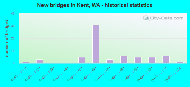
- New bridges - historical statistics
- 11910-1919
- 31920-1929
- 51950-1959
- 311960-1969
- 31970-1979
- 61980-1989
- 51990-1999
- 52000-2009
- 62010-2019
- 12020-2022
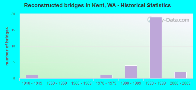
- Reconstructed bridges - Historical Statistics
- 11940-1949
- 01950-1959
- 01960-1969
- 11970-1979
- 41980-1989
- 191990-1999
- 22000-2009
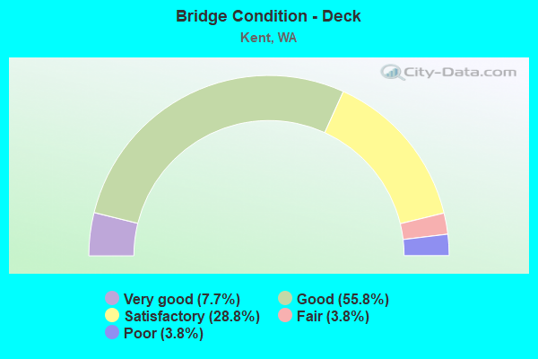
- Bridge Condition - Deck
- 7.7%Very good
- 55.8%Good
- 28.8%Satisfactory
- 3.8%Fair
- 3.8%Poor
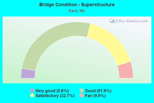
- Bridge Condition - Superstructure
- 5.8%Very good
- 51.9%Good
- 32.7%Satisfactory
- 9.6%Fair
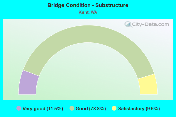
- Bridge Condition - Substructure
- 11.5%Very good
- 78.8%Good
- 9.6%Satisfactory
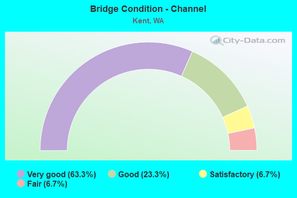
- Bridge Condition - Channel
- 63.3%Very good
- 23.3%Good
- 6.7%Satisfactory
- 6.7%Fair
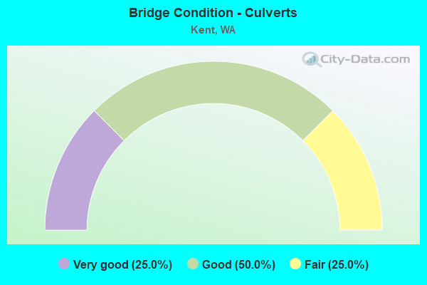
- Bridge Condition - Culverts
- 25.0%Very good
- 50.0%Good
- 25.0%Fair
Find on map >> Show street view
Structure Number: 82938, Location: 0.25 MI N OF SE 256TH ST (Lat: 47.374731, Lng: -122.144200), Route carried "on" structure: City street 615, Year Built: 1971, Status: Open, Structure Length: 0.91m (2.99ft), Average Daily Traffic: 2,300 (year 2019), Truck Traffic: 5%, Average Future Daily Traffic: 4,100 (year 2039), Design Load: HS 20, Features Intersected: SOOS CREEK, Facility Carried by Structure: 148TH AVE SE
Minimum Vertical Clearance: 30+ m (98+ ft), Kilometerpoint: 0.001, Lanes on structure: 2, Owner: City or Municipal Highway Agency, Approaching Roadway Width: 7.9m (25.9ft), Skew: 2 degrees, Material/Design: Concrete, Design/Construction: Channel Beam, Number Of Spans In Main Unit: 1, Length of Maximum Span: 7.6m (24.9ft), Curb-To-Curb Width: 10.4m (34.1ft), Out-to-Out Width: 11.6m (38.1ft)
Condition: Deck: Fair, Superstructure: Fair, Substructure: Good, Channel: Very good, Operating Rating: 46.0 metric tons, Method Used To Determine Operating Rating: Load Factor (LF) rating reported by rating factor (RF) method using MS18 loading, Inventory Rating: 27.5 metric tons, Method Used To Determine Inventory Rating: Load Factor (LF) rating reported by rating factor (RF) method using MS18 loading, Structural Evaluation: Somewhat better than minimum adequacy, Deck Geometry: Somewhat better than minimum adequacy, Waterway Adequacy: Equal to present minimum criteria, Approach Roadway Alignment: Equal to present desirable criteria, Length Of Structure Improvement: 1.22m (4.00ft), Designated Inspection Frequency: Every 24 months, Underwater Inspection Frequency: Every 60 months, Inspection Date: April 2020, Underwater Inspection Date: July 2020, Bridge Improvement Cost: $608,000, Roadway Improvement Cost: $122,000, Total Project Cost: $1,216,000 ( Estimate for 2014), Deck Structure Type: Concrete Precast Panels
Find on map >> Show street view
Structure Number: 82997, Location: SE 256TH ST @ 148 AVE SE (Lat: 47.372367, Lng: -122.144419), Route carried "on" structure: County highway 1330, Year Built: 1927, Year Reconstructed: 1951, Status: Open, Structure Length: 1.01m (3.31ft), Average Daily Traffic: 8,000 (year 2018), Truck Traffic: 5%, Average Future Daily Traffic: 10,500 (year 2038), Design Load: HS 15, Features Intersected: SOOS CREEK, Facility Carried by Structure: SE 256TH ST
Minimum Vertical Clearance: 30+ m (98+ ft), Kilometerpoint: 0.001, Lanes on structure: 2, Owner: City or Municipal Highway Agency, Approaching Roadway Width: 9.1m (29.9ft), Material/Design: Concrete continuous, Design/Construction: Slab, Number Of Spans In Main Unit: 2, Length of Maximum Span: 4.6m (15.1ft), Curb or Sidewalk Widths: Left: 1.4m (4.6ft), Right: 0.0m, Curb-To-Curb Width: 7.1m (23.3ft), Out-to-Out Width: 7.7m (25.3ft)
Condition: Deck: Fair, Superstructure: Fair, Substructure: Good, Channel: Very good, Operating Rating: 35.3 metric tons, Method Used To Determine Operating Rating: Load Factor (LF) rating reported by rating factor (RF) method using MS18 loading, Inventory Rating: 21.1 metric tons, Method Used To Determine Inventory Rating: Load Factor (LF) rating reported by rating factor (RF) method using MS18 loading, Structural Evaluation: Somewhat better than minimum adequacy, Deck Geometry: High priority of replacement, Waterway Adequacy: High priority of corrective action, Approach Roadway Alignment: Equal to present desirable criteria, Length Of Structure Improvement: 1.01m (3.31ft), Designated Inspection Frequency: Every 24 months, Underwater Inspection Frequency: Every 60 months, Inspection Date: April 2020, Underwater Inspection Date: July 2020, Bridge Improvement Cost: $211,000, Roadway Improvement Cost: $42,000, Total Project Cost: $422,000 ( Estimate for 2014), Deck Structure Type: Concrete Cast-file-Place, Wearing Surface/Protective System: Wearing Surface: Monolithic Concrete
Find on map >> Show street view
Structure Number: 85156, Location: 0.72 MI W OF 68TH AV S (Lat: 47.412361, Lng: -122.265194), Route carried "on" structure: City street 1250, Year Built: 1966, Status: Open, Structure Length: 5.91m (19.39ft), Average Daily Traffic: 35,500 (year 2018), Truck Traffic: 20%, Average Future Daily Traffic: 46,000 (year 2038), Design Load: HS 20, Features Intersected: GREEN RIVER, Facility Carried by Structure: S 212th ST
Minimum Vertical Clearance: 30+ m (98+ ft), Kilometerpoint: 0.001, Lanes on structure: 4, Base Highway Network: Yes, Owner: City or Municipal Highway Agency, Approaching Roadway Width: 14.0m (45.9ft), Skew: 31 degrees, Material/Design: Steel continuous, Design/Construction: Stringer/Multi-beam, Number Of Spans In Main Unit: 3, Length of Maximum Span: 39.6m (129.9ft), Curb or Sidewalk Widths: Left: 1.3m (4.3ft), Right: 1.3m (4.3ft), Curb-To-Curb Width: 14.6m (47.9ft), Out-to-Out Width: 17.2m (56.4ft)
Condition: Deck: Satisfactory, Superstructure: Satisfactory, Substructure: Good, Channel: Good, Operating Rating: 58.3 metric tons, Method Used To Determine Operating Rating: Load Factor (LF) rating reported by rating factor (RF) method using MS18 loading, Inventory Rating: 35.0 metric tons, Method Used To Determine Inventory Rating: Load Factor (LF) rating reported by rating factor (RF) method using MS18 loading, Structural Evaluation: Equal to present minimum criteria, Deck Geometry: High priority of replacement, Waterway Adequacy: Equal to present desirable criteria, Approach Roadway Alignment: Equal to present desirable criteria, Length Of Structure Improvement: 5.91m (19.39ft), Designated Inspection Frequency: Every 24 months, Inspection Date: April 2020, Bridge Improvement Cost: $1,862,000, Roadway Improvement Cost: $372,000, Total Project Cost: $3,725,000 ( Estimate for 2014), Deck Structure Type: Concrete Cast-file-Place, Wearing Surface/Protective System: Wearing Surface: Integral Concrete
Find on map >> Show street view
Structure Number: 85399, Location: 0.4 MI S JCT SR-516 (Lat: 47.376194, Lng: -122.265750), Route carried "on" structure: City street 615, Year Built: 1950, Status: Posted for load, Structure Length: 2.01m (6.59ft), Average Daily Traffic: 1,600 (year 2016), Truck Traffic: 1%, Average Future Daily Traffic: 1,950 (year 2037), Design Load: H 15, Features Intersected: UN NAMED STREAM, Facility Carried by Structure: S FRAGGER ROAD
Minimum Vertical Clearance: 30+ m (98+ ft), Kilometerpoint: 0.001, Lanes on structure: 2, Owner: City or Municipal Highway Agency, Approaching Roadway Width: 7.3m (24.0ft), Material/Design: Concrete continuous, Design/Construction: Slab, Number Of Spans In Main Unit: 3, Length of Maximum Span: 7.6m (24.9ft), Curb or Sidewalk Widths: Left: 0.6m (2.0ft), Right: 0.6m (2.0ft), Curb-To-Curb Width: 7.3m (24.0ft), Out-to-Out Width: 8.8m (28.9ft)
Condition: Deck: Satisfactory, Superstructure: Satisfactory, Substructure: Satisfactory, Channel: Fair, Operating Rating: 19.4 metric tons, Method Used To Determine Operating Rating: Load and Resistance Factor Rating (LRFR) rating reported by rating factor(RF) method using HL-93 loadings, Inventory Rating: 14.9 metric tons, Method Used To Determine Inventory Rating: Load and Resistance Factor Rating (LRFR) rating reported by rating factor(RF) method using HL-93 loadings, Structural Evaluation: Meets minimum limits, Deck Geometry: Meets minimum limits, Waterway Adequacy: Equal to present desirable criteria, Approach Roadway Alignment: Equal to present desirable criteria, Bridge Posting: Required (Relationship of Operating Rating to Maximum Legal Load: 10.0 - 19.9% below), Length Of Structure Improvement: 2.32m (7.61ft), Designated Inspection Frequency: Every 24 months, Inspection Date: April 2020, Bridge Improvement Cost: $1,155,000, Roadway Improvement Cost: $231,000, Total Project Cost: $2,310,000 ( Estimate for 2014), Deck Structure Type: Concrete Cast-file-Place, Wearing Surface/Protective System: Wearing Surface: Bituminous
Find on map >> Show street view
Structure Number: 85851, Location: 0.7 MI E OF SR-167 (Lat: 47.361000, Lng: -122.229917), Route carried "on" structure: County highway 92643, Year Built: 1990, Status: Open, Structure Length: 7.62m (25.00ft), Average Daily Traffic: 18,758 (year 2019), Truck Traffic: 10%, Average Future Daily Traffic: 25,000 (year 2039), Design Load: HS 20+Mod, Features Intersected: GREEN RIVER, Facility Carried by Structure: 83RD AVE S
Minimum Vertical Clearance: 30+ m (98+ ft), Kilometerpoint: 0.001, Lanes on structure: 4, Owner: County Highway Agency, Approaching Roadway Width: 14.6m (47.9ft), Skew: 2 degrees, Material/Design: Steel, Design/Construction: Stringer/Multi-beam, Number Of Spans In Main Unit: 1, Number Of Approach Spans: 2, Length of Maximum Span: 48.8m (160.1ft), Curb or Sidewalk Widths: Left: 2.0m (6.6ft), Right: 2.0m (6.6ft), Curb-To-Curb Width: 14.6m (47.9ft), Out-to-Out Width: 18.6m (61.0ft)
Condition: Deck: Satisfactory, Superstructure: Satisfactory, Substructure: Good, Channel: Very good, Operating Rating: 25.4 metric tons, Method Used To Determine Operating Rating: Load and Resistance Factor (LRFR), Inventory Rating: 20.0 metric tons, Method Used To Determine Inventory Rating: Load and Resistance Factor (LRFR), Structural Evaluation: Somewhat better than minimum adequacy, Deck Geometry: High priority of replacement, Waterway Adequacy: Equal to present desirable criteria, Approach Roadway Alignment: Equal to present desirable criteria, Length Of Structure Improvement: 7.92m (25.98ft), Designated Inspection Frequency: Every 24 months, Inspection Date: August 2020, Bridge Improvement Cost: $6,448,000, Roadway Improvement Cost: $1,290,000, Total Project Cost: $12,896,000 ( Estimate for 2014), Deck Structure Type: Concrete Precast Panels, Wearing Surface/Protective System: Wearing Surface: Latex Concrete, Deck Protection: Epoxy Coated Reinforcing
Find on map >> Show street view
Structure Number: 85893, Location: 0.1 MI E OF JCT SR-516 (Lat: 47.378422, Lng: -122.269053), Route carried "on" structure: City street 1068, Year Built: 1958, Status: Open, Structure Length: 7.47m (24.51ft), Average Daily Traffic: 25,000 (year 2018), Truck Traffic: 8%, Average Future Daily Traffic: 35,000 (year 2038), Design Load: HS 15, Features Intersected: GREEN RIVER, Facility Carried by Structure: MEEKER ROAD
Minimum Vertical Clearance: 4.72m (15.49ft), Kilometerpoint: 0.001, Lanes on structure: 2, Owner: City or Municipal Highway Agency, Approaching Roadway Width: 12.2m (40.0ft), Material/Design: Steel, Design/Construction: Truss - Thru, Number Of Spans In Main Unit: 1, Length of Maximum Span: 73.2m (240.2ft), Curb or Sidewalk Widths: Left: 0.9m (3.0ft), Right: 0.9m (3.0ft), Curb-To-Curb Width: 7.9m (25.9ft), Out-to-Out Width: 10.8m (35.4ft)
Condition: Deck: Poor, Superstructure: Satisfactory, Substructure: Satisfactory, Channel: Satisfactory, Operating Rating: 32.7 metric tons, Method Used To Determine Operating Rating: Load and Resistance Factor Rating (LRFR) rating reported by rating factor(RF) method using HL-93 loadings, Inventory Rating: 25.3 metric tons, Method Used To Determine Inventory Rating: Load and Resistance Factor Rating (LRFR) rating reported by rating factor(RF) method using HL-93 loadings, Structural Evaluation: Equal to present minimum criteria, Deck Geometry: High priority of corrective action, Waterway Adequacy: Equal to present desirable criteria, Approach Roadway Alignment: Equal to present desirable criteria, Length Of Structure Improvement: 7.77m (25.49ft), Designated Inspection Frequency: Every 24 months, Critical Feature Inspection Frequency: Every 24 months, Inspection Date: April 2020, Critical Feature Inspection Date: April 2020, Bridge Improvement Cost: $3,876,000, Roadway Improvement Cost: $775,000, Total Project Cost: $7,752,000 ( Estimate for 2014), Deck Structure Type: Concrete Cast-file-Place, Wearing Surface/Protective System: Wearing Surface: Monolithic Concrete
Find on map >> Show street view
Structure Number: 87121, Location: 0.8 MI W OF SR-18 (Lat: 47.422878, Lng: -122.266122), Route carried "on" structure: County highway 196, Year Built: 1998, Status: Open, Structure Length: 9.91m (32.51ft), Average Daily Traffic: 17,406 (year 2018), Truck Traffic: 9%, Average Future Daily Traffic: 21,500 (year 2039), Design Load: HL 93, Features Intersected: GREEN RIVER
Minimum Vertical Clearance: 30+ m (98+ ft), Kilometerpoint: 0.001, Lanes on structure: 4, Owner: City or Municipal Highway Agency, Maintenance Responsibility: County Highway Agency, Approaching Roadway Width: 18.3m (60.0ft), Skew: 30 degrees, Material/Design: Prestressed concrete continuous, Design/Construction: Box Beam or Girders - Multiple, Number Of Spans In Main Unit: 2, Number Of Approach Spans: 1, Length of Maximum Span: 51.8m (169.9ft), Curb or Sidewalk Widths: Left: 1.7m (5.6ft), Right: 1.7m (5.6ft), Curb-To-Curb Width: 18.3m (60.0ft), Out-to-Out Width: 22.3m (73.2ft)
Condition: Deck: Satisfactory, Superstructure: Satisfactory, Substructure: Satisfactory, Channel: Very good, Operating Rating: 45.4 metric tons, Method Used To Determine Operating Rating: Load Factor (LF), Inventory Rating: 41.7 metric tons, Method Used To Determine Inventory Rating: Load Factor (LF), Structural Evaluation: Equal to present minimum criteria, Deck Geometry: Somewhat better than minimum adequacy, Waterway Adequacy: Equal to present desirable criteria, Approach Roadway Alignment: High priority of corrective action, Length Of Structure Improvement: 9.91m (32.51ft), Designated Inspection Frequency: Every 24 months, Inspection Date: April 2021, Bridge Improvement Cost: $4,030,000, Roadway Improvement Cost: $806,000, Total Project Cost: $8,060,000 ( Estimate for 2014), Deck Structure Type: Concrete Cast-file-Place, Wearing Surface/Protective System: Wearing Surface: Monolithic Concrete
Find on map >> Show street view
Structure Number: 87148, Location: 27400 108TH AVE SE (Lat: 47.355950, Lng: -122.196933), Route carried "on" structure: City street 615, Year Built: 1998, Status: Open, Structure Length: 4.85m (15.91ft), Average Daily Traffic: 8,300 (year 2020), Truck Traffic: 3%, Average Future Daily Traffic: 11,000 (year 2037), Design Load: HS 25 or greater, Features Intersected: SE 274TH ST, Facility Carried by Structure: 108TH AVE SE
Minimum Vertical Clearance: 30+ m (98+ ft), Kilometerpoint: 0.001, Lanes on structure: 3, Lanes under structure: 5, Owner: City or Municipal Highway Agency, Approaching Roadway Width: 11.0m (36.1ft), Material/Design: Concrete, Design/Construction: Box Beam or Girders - Multiple, Number Of Spans In Main Unit: 1, Length of Maximum Span: 46.3m (151.9ft), Curb or Sidewalk Widths: Left: 3.2m (10.5ft), Right: 3.2m (10.5ft), Curb-To-Curb Width: 11.0m (36.1ft), Out-to-Out Width: 18.0m (59.1ft)
Condition: Deck: Good, Superstructure: Good, Substructure: Good, Operating Rating: 69.0 metric tons, Method Used To Determine Operating Rating: Load and Resistance Factor Rating (LRFR) rating reported by rating factor(RF) method using HL-93 loadings, Inventory Rating: 29.2 metric tons, Method Used To Determine Inventory Rating: Load and Resistance Factor Rating (LRFR) rating reported by rating factor(RF) method using HL-93 loadings, Structural Evaluation: Better than present minimum criteria, Deck Geometry: High priority of replacement, Underclear: Somewhat better than minimum adequacy, Approach Roadway Alignment: Equal to present desirable criteria, Length Of Structure Improvement: 4.85m (15.91ft), Designated Inspection Frequency: Every 24 months, Inspection Date: April 2020, Bridge Improvement Cost: $1,208,000, Roadway Improvement Cost: $242,000, Total Project Cost: $2,417,000 ( Estimate for 2014), Deck Structure Type: Concrete Cast-file-Place, Wearing Surface/Protective System: Wearing Surface: Monolithic Concrete, Deck Protection: Epoxy Coated Reinforcing
Find on map >> Show street view
Structure Number: 87149, Location: 7200 S 196TH ST (Lat: 47.426522, Lng: -122.239547), Route carried "on" structure: City street 72196, Year Built: 2000, Status: Open, Structure Length: 38.07m (124.90ft), Average Daily Traffic: 11,000 (year 2020), Truck Traffic: 15%, Average Future Daily Traffic: 15,000 (year 2040), Design Load: HS 25 or greater, Features Intersected: UPRR, 77TH AVE S, BNSFRR, Facility Carried by Structure: S 196TH ST
Minimum Vertical Clearance: 30+ m (98+ ft), Kilometerpoint: 0.001, Lanes on structure: 4, Lanes under structure: 2, Owner: City or Municipal Highway Agency, Approaching Roadway Width: 15.8m (51.8ft), Skew: 39 degrees, Material/Design: Steel continuous, Design/Construction: Stringer/Multi-beam, Number Of Spans In Main Unit: 6, Number Of Approach Spans: 1, Length of Maximum Span: 69.5m (228.0ft), Curb or Sidewalk Widths: Left: 2.1m (6.9ft), Right: 2.1m (6.9ft), Curb-To-Curb Width: 15.2m (49.9ft), Out-to-Out Width: 20.7m (67.9ft)
Condition: Deck: Satisfactory, Superstructure: Satisfactory, Substructure: Good, Operating Rating: 75.3 metric tons, Method Used To Determine Operating Rating: Field evaluation and documented engineering judgment, Inventory Rating: 45.4 metric tons, Method Used To Determine Inventory Rating: Field evaluation and documented engineering judgment, Structural Evaluation: Equal to present minimum criteria, Deck Geometry: High priority of corrective action, Underclear: Meets minimum limits, Approach Roadway Alignment: Equal to present desirable criteria, Length Of Structure Improvement: 38.07m (124.90ft), Designated Inspection Frequency: Every 24 months, Inspection Date: April 2020, Bridge Improvement Cost: $13,489,000, Roadway Improvement Cost: $2,698,000, Total Project Cost: $26,978,000 ( Estimate for 2014), Deck Structure Type: Concrete Cast-file-Place, Wearing Surface/Protective System: Wearing Surface: Monolithic Concrete, Deck Protection: Epoxy Coated Reinforcing
Find on map >> Show street view
Structure Number: 8715, Location: GREEN RIVER AT S 277TH ST (Lat: 47.354444, Lng: -122.209944), Route carried "on" structure: City street 615, Year Built: 2000, Status: Open, Structure Length: 14.23m (46.69ft), Average Daily Traffic: 21,300 (year 2020), Truck Traffic: 5%, Average Future Daily Traffic: 23,000 (year 2040), Design Load: HS 25 or greater, Features Intersected: GREEN RV & GREEN RV RD., Facility Carried by Structure: S 277TH ST
Minimum Vertical Clearance: 30+ m (98+ ft), Kilometerpoint: 0.001, Lanes on structure: 5, Lanes under structure: 2, Base Highway Network: Yes, Owner: City or Municipal Highway Agency, Approaching Roadway Width: 23.5m (77.1ft), Skew: 33 degrees, Material/Design: Concrete, Design/Construction: Box Beam or Girders - Multiple, Number Of Spans In Main Unit: 3, Length of Maximum Span: 55.8m (183.1ft), Curb-To-Curb Width: 22.9m (75.1ft), Out-to-Out Width: 24.7m (81.0ft)
Condition: Deck: Good, Superstructure: Good, Substructure: Good, Channel: Very good, Operating Rating: 65.4 metric tons, Method Used To Determine Operating Rating: Load Factor (LF) rating reported by rating factor (RF) method using MS18 loading, Inventory Rating: 39.2 metric tons, Method Used To Determine Inventory Rating: Load Factor (LF) rating reported by rating factor (RF) method using MS18 loading, Structural Evaluation: Better than present minimum criteria, Deck Geometry: Equal to present minimum criteria, Underclear: High priority of replacement, Waterway Adequacy: Equal to present desirable criteria, Approach Roadway Alignment: Equal to present desirable criteria, Length Of Structure Improvement: 14.54m (47.70ft), Designated Inspection Frequency: Every 24 months, Inspection Date: April 2020, Bridge Improvement Cost: $14,119,000, Roadway Improvement Cost: $2,824,000, Total Project Cost: $28,238,000 ( Estimate for 2014), Deck Structure Type: Concrete Cast-file-Place, Wearing Surface/Protective System: Wearing Surface: Monolithic Concrete, Deck Protection: Epoxy Coated Reinforcing
Find on map >> Show street view
Structure Number: 87787, Location: 2.0 MI E OF I-5 (Lat: 47.395889, Lng: -122.274222), Route carried "on" structure: City street 615, Year Built: 2006, Status: Open, Structure Length: 10.85m (35.60ft), Average Daily Traffic: 5,200 (year 2019), Truck Traffic: 12%, Average Future Daily Traffic: 7,500 (year 2039), Design Load: HL 93, Features Intersected: GREEN RIVER, Facility Carried by Structure: Veterans Dr.
Minimum Vertical Clearance: 30+ m (98+ ft), Kilometerpoint: 0.001, Lanes on structure: 4, Owner: City or Municipal Highway Agency, Approaching Roadway Width: 15.8m (51.8ft), Skew: 30 degrees, Material/Design: Steel, Design/Construction: Stringer/Multi-beam, Number Of Spans In Main Unit: 1, Number Of Approach Spans: 2, Length of Maximum Span: 64.0m (210.0ft), Curb or Sidewalk Widths: Left: 2.1m (6.9ft), Right: 2.1m (6.9ft), Curb-To-Curb Width: 15.8m (51.8ft), Out-to-Out Width: 20.7m (67.9ft)
Condition: Deck: Good, Superstructure: Very good, Substructure: Very good, Channel: Very good, Operating Rating: 71.9 metric tons, Method Used To Determine Operating Rating: Load and Resistance Factor Rating (LRFR) rating reported by rating factor(RF) method using HL-93 loadings, Inventory Rating: 55.4 metric tons, Method Used To Determine Inventory Rating: Load and Resistance Factor Rating (LRFR) rating reported by rating factor(RF) method using HL-93 loadings, Structural Evaluation: Equal to present desirable criteria, Deck Geometry: Meets minimum limits, Waterway Adequacy: Equal to present desirable criteria, Approach Roadway Alignment: Equal to present desirable criteria, Length Of Structure Improvement: 10.85m (35.60ft), Designated Inspection Frequency: Every 24 months, Inspection Date: April 2020, Bridge Improvement Cost: $3,845,000, Roadway Improvement Cost: $769,000, Total Project Cost: $7,690,000 ( Estimate for 2014), Deck Structure Type: Concrete Cast-file-Place, Wearing Surface/Protective System: Wearing Surface: Monolithic Concrete, Deck Protection: Epoxy Coated Reinforcing
Find on map >> Show street view
Structure Number: 87788, Location: 1.5 MI E OF I-5 (Lat: 47.395333, Lng: -122.281556), Route carried "on" structure: City street 615, Year Built: 2007, Status: Open, Structure Length: 4.45m (14.60ft), Average Daily Traffic: 700 (year 2016), Truck Traffic: 5%, Average Future Daily Traffic: 1,500 (year 2038), Design Load: HL 93, Features Intersected: Veterans Dr., Facility Carried by Structure: Riverview Blvd. S
Minimum Vertical Clearance: 30+ m (98+ ft), Kilometerpoint: 0.001, Lanes on structure: 2, Lanes under structure: 5, Owner: City or Municipal Highway Agency, Approaching Roadway Width: 11.0m (36.1ft), Material/Design: Prestressed concrete, Design/Construction: Stringer/Multi-beam, Number Of Spans In Main Unit: 1, Length of Maximum Span: 42.7m (140.1ft), Curb or Sidewalk Widths: Left: 2.1m (6.9ft), Right: 2.1m (6.9ft), Curb-To-Curb Width: 11.0m (36.1ft), Out-to-Out Width: 15.8m (51.8ft)
Condition: Deck: Good, Superstructure: Very good, Substructure: Very good, Operating Rating: 64.5 metric tons, Method Used To Determine Operating Rating: Load and Resistance Factor Rating (LRFR) rating reported by rating factor(RF) method using HL-93 loadings, Inventory Rating: 48.3 metric tons, Method Used To Determine Inventory Rating: Load and Resistance Factor Rating (LRFR) rating reported by rating factor(RF) method using HL-93 loadings, Structural Evaluation: Equal to present desirable criteria, Deck Geometry: Better than present minimum criteria, Underclear: Equal to present minimum criteria, Approach Roadway Alignment: Equal to present desirable criteria, Length Of Structure Improvement: 4.45m (14.60ft), Designated Inspection Frequency: Every 24 months, Inspection Date: April 2020, Bridge Improvement Cost: $1,110,000, Roadway Improvement Cost: $222,000, Total Project Cost: $2,219,000 ( Estimate for 2014), Deck Structure Type: Concrete Cast-file-Place, Wearing Surface/Protective System: Wearing Surface: Monolithic Concrete, Deck Protection: Epoxy Coated Reinforcing
Find on map >> Show street view
Structure Number: 88228, Location: 23900 LAKESIDE BLVD E (Lat: 47.387681, Lng: -122.259764), Route carried "on" structure: City street 615, Year Built: 1985, Status: Open, Structure Length: 0.67m (2.20ft), Average Daily Traffic: 550 (year 2018), Truck Traffic: 2%, Average Future Daily Traffic: 650 (year 2038), Design Load: H 20, Features Intersected: KENT LAKES, Facility Carried by Structure: LAKESIDE BLVD E
Minimum Vertical Clearance: 30+ m (98+ ft), Kilometerpoint: 0.001, Lanes on structure: 2, Owner: City or Municipal Highway Agency, Approaching Roadway Width: 10.4m (34.1ft), Material/Design: Aluminum, Iron, Design/Construction: Culvert, Number Of Spans In Main Unit: 1, Length of Maximum Span: 6.7m (22.0ft), Curb or Sidewalk Widths: Left: 1.7m (5.6ft), Right: 1.7m (5.6ft), Curb-To-Curb Width: 10.4m (34.1ft), Out-to-Out Width: 14.3m (46.9ft)
Condition: Channel: Very good, Culverts: Good, Operating Rating: 87.2 metric tons, Method Used To Determine Operating Rating: Load and Resistance Factor Rating (LRFR) rating reported by rating factor(RF) method using HL-93 loadings, Inventory Rating: 52.2 metric tons, Method Used To Determine Inventory Rating: Load and Resistance Factor Rating (LRFR) rating reported by rating factor(RF) method using HL-93 loadings, Structural Evaluation: Better than present minimum criteria, Deck Geometry: Equal to present minimum criteria, Waterway Adequacy: Equal to present desirable criteria, Approach Roadway Alignment: Equal to present desirable criteria, Length Of Structure Improvement: 0.67m (2.20ft), Designated Inspection Frequency: Every 24 months, Underwater Inspection Frequency: Every 60 months, Inspection Date: April 2020, Underwater Inspection Date: July 2020, Bridge Improvement Cost: $158,000, Roadway Improvement Cost: $32,000, Total Project Cost: $317,000 ( Estimate for 2014)
Find on map >> Show street view
Structure Number: 88651, Location: 0.2 MI W OF SR-167 (Lat: 47.397592, Lng: -122.233864), Route carried "on" structure: City street 615, Year Built: 2009, Status: Open, Structure Length: 3.90m (12.80ft), Average Daily Traffic: 2,200 (year 2018), Truck Traffic: 5%, Average Future Daily Traffic: 3,100 (year 2038), Design Load: HL 93, Features Intersected: BNSF RR, Facility Carried by Structure: S 228TH STREET
Minimum Vertical Clearance: 30+ m (98+ ft), Kilometerpoint: 0.001, Lanes on structure: 4, Owner: City or Municipal Highway Agency, Approaching Roadway Width: 14.6m (47.9ft), Material/Design: Prestressed concrete continuous, Design/Construction: Tee Beam, Number Of Spans In Main Unit: 1, Number Of Approach Spans: 3, Length of Maximum Span: 32.3m (106.0ft), Curb or Sidewalk Widths: Left: 3.0m (9.8ft), Right: 3.0m (9.8ft), Curb-To-Curb Width: 14.6m (47.9ft), Out-to-Out Width: 21.3m (69.9ft)
Condition: Deck: Good, Superstructure: Good, Substructure: Good, Operating Rating: 43.1 metric tons, Method Used To Determine Operating Rating: Load and Resistance Factor Rating (LRFR) rating reported by rating factor(RF) method using HL-93 loadings, Inventory Rating: 33.4 metric tons, Method Used To Determine Inventory Rating: Load and Resistance Factor Rating (LRFR) rating reported by rating factor(RF) method using HL-93 loadings, Structural Evaluation: Better than present minimum criteria, Deck Geometry: High priority of replacement, Underclear: Superior to present desirable criteria, Approach Roadway Alignment: Equal to present minimum criteria, Length Of Structure Improvement: 3.90m (12.80ft), Designated Inspection Frequency: Every 24 months, Inspection Date: April 2020, Bridge Improvement Cost: $1,280,000, Roadway Improvement Cost: $256,000, Total Project Cost: $2,560,000 ( Estimate for 2014), Deck Structure Type: Concrete Cast-file-Place, Wearing Surface/Protective System: Deck Protection: Epoxy Coated Reinforcing
Find on map >> Show street view
Structure Number: 88997, Location: 0.25 MI E OF SR-181 (Lat: 47.424806, Lng: -122.244528), Route carried "on" structure: City street 615, Year Built: 2017, Status: Open, Structure Length: 3.23m (10.60ft), Average Daily Traffic: 5,000 (year 2018), Truck Traffic: 20%, Average Future Daily Traffic: 7,500 (year 2038), Design Load: HL 93, Features Intersected: Mill Creek, Facility Carried by Structure: 72ND AVENUE SOUTH
Minimum Vertical Clearance: 30+ m (98+ ft), Kilometerpoint: 0.001, Lanes on structure: 2, Owner: City or Municipal Highway Agency, Approaching Roadway Width: 9.8m (32.2ft), Skew: 3 degrees, Material/Design: Prestressed concrete, Design/Construction: Box Beam or Girders - Multiple, Number Of Spans In Main Unit: 1, Length of Maximum Span: 30.5m (100.1ft), Curb or Sidewalk Widths: Left: 2.1m (6.9ft), Right: 2.1m (6.9ft), Curb-To-Curb Width: 9.8m (32.2ft), Out-to-Out Width: 14.5m (47.6ft)
Condition: Deck: Good, Superstructure: Good, Substructure: Good, Channel: Very good, Operating Rating: 92.0 metric tons, Method Used To Determine Operating Rating: Load and Resistance Factor Rating (LRFR) rating reported by rating factor(RF) method using HL-93 loadings, Inventory Rating: 48.9 metric tons, Method Used To Determine Inventory Rating: Load and Resistance Factor Rating (LRFR) rating reported by rating factor(RF) method using HL-93 loadings, Structural Evaluation: Better than present minimum criteria, Deck Geometry: Meets minimum limits, Waterway Adequacy: Equal to present desirable criteria, Approach Roadway Alignment: Equal to present desirable criteria, Length Of Structure Improvement: 3.23m (10.60ft), Designated Inspection Frequency: Every 24 months, Inspection Date: April 2020, Bridge Improvement Cost: $721,000, Roadway Improvement Cost: $144,000, Total Project Cost: $1,442,000 ( Estimate for 2014), Deck Structure Type: Concrete Cast-file-Place, Wearing Surface/Protective System: Wearing Surface: Monolithic Concrete
Find on map >> Show street view
Structure Number: 89147, Location: 0.25 MI E of SR 167 (Lat: 47.406764, Lng: -122.216319), Route carried "on" structure: City street 615, Year Built: 2019, Status: Open, Structure Length: 0.94m (3.08ft), Average Daily Traffic: 3,000 (year 2018), Truck Traffic: 1%, Average Future Daily Traffic: 7,000 (year 2038), Design Load: HL 93, Features Intersected: GARRISON CREEK, Facility Carried by Structure: S 218TH STREET
Minimum Vertical Clearance: 30+ m (98+ ft), Kilometerpoint: 0.001, Lanes on structure: 3, Owner: City or Municipal Highway Agency, Approaching Roadway Width: 13.4m (44.0ft), Material/Design: Concrete, Design/Construction: Culvert, Number Of Spans In Main Unit: 1, Length of Maximum Span: 8.8m (28.9ft), Curb or Sidewalk Widths: Left: 1.5m (4.9ft), Right: 1.5m (4.9ft), Curb-To-Curb Width: 13.4m (44.0ft), Out-to-Out Width: 19.8m (65.0ft)
Condition: Channel: Very good, Culverts: Very good, Operating Rating: 80.7 metric tons, Method Used To Determine Operating Rating: Load and Resistance Factor Rating (LRFR) rating reported by rating factor(RF) method using HL-93 loadings, Inventory Rating: 50.5 metric tons, Method Used To Determine Inventory Rating: Load and Resistance Factor Rating (LRFR) rating reported by rating factor(RF) method using HL-93 loadings, Structural Evaluation: Equal to present desirable criteria, Deck Geometry: Somewhat better than minimum adequacy, Waterway Adequacy: Equal to present desirable criteria, Approach Roadway Alignment: Equal to present desirable criteria, Length Of Structure Improvement: 0.94m (3.08ft), Designated Inspection Frequency: Every 24 months, Inspection Date: April 2020, Bridge Improvement Cost: $285,000, Roadway Improvement Cost: $57,000, Total Project Cost: $570,000 ( Estimate for 2014), Wearing Surface/Protective System: Wearing Surface: Bituminous, Membrane: Preformed Fabric
Find on map >> Show street view
Structure Number: 89151, Location: 0.15 E 84TH AVE S (Lat: 47.401194, Lng: -122.224806), Route carried "on" structure: City street 615, Year Built: 2019, Status: Open, Structure Length: 13.38m (43.90ft), Average Daily Traffic: 2,200 (year 2018), Truck Traffic: 5%, Average Future Daily Traffic: 3,100 (year 2038), Features Intersected: SR 167, 88TH AVE S, Facility Carried by Structure: S 224TH STREET
Minimum Vertical Clearance: 30+ m (98+ ft), Kilometerpoint: 0.001, Lanes on structure: 2, Lanes under structure: 8, Owner: City or Municipal Highway Agency, Approaching Roadway Width: 13.4m (44.0ft), Skew: 4 degrees, Material/Design: Prestressed concrete continuous, Design/Construction: Stringer/Multi-beam, Number Of Spans In Main Unit: 3, Number Of Approach Spans: 2, Length of Maximum Span: 53.3m (174.9ft), Curb or Sidewalk Widths: Left: 0.0m, Right: 2.1m (6.9ft), Curb-To-Curb Width: 10.4m (34.1ft), Out-to-Out Width: 13.5m (44.3ft)
Condition: Deck: Very good, Superstructure: Very good, Substructure: Very good, Operating Rating: 56.4 metric tons, Method Used To Determine Operating Rating: Load and Resistance Factor Rating (LRFR) rating reported by rating factor(RF) method using HL-93 loadings, Inventory Rating: 43.4 metric tons, Method Used To Determine Inventory Rating: Load and Resistance Factor Rating (LRFR) rating reported by rating factor(RF) method using HL-93 loadings, Structural Evaluation: Equal to present desirable criteria, Deck Geometry: Somewhat better than minimum adequacy, Underclear: Equal to present minimum criteria, Approach Roadway Alignment: Equal to present minimum criteria, Length Of Structure Improvement: 13.38m (43.90ft), Designated Inspection Frequency: Every 24 months, Inspection Date: April 2020, Bridge Improvement Cost: $4,039,000, Roadway Improvement Cost: $808,000, Total Project Cost: $8,078,000 ( Estimate for 2014), Deck Structure Type: Concrete Cast-file-Place
Find on map >> Show street view
Structure Number: 89213, Location: .02 MI E OF 118TH AVE SE (Lat: 47.336556, Lng: -122.182917), Route carried "on" structure: City street 615, Year Built: 2018, Status: Open, Structure Length: 1.65m (5.41ft), Average Daily Traffic: 200 (year 2021), Truck Traffic: 1%, Average Future Daily Traffic: 300 (year 2041), Design Load: HL 93, Features Intersected: OLSEN CREEK, Facility Carried by Structure: SE 296TH PL
Minimum Vertical Clearance: 30+ m (98+ ft), Kilometerpoint: 0.001, Lanes on structure: 1, Owner: City or Municipal Highway Agency, Approaching Roadway Width: 11.3m (37.1ft), Material/Design: Prestressed concrete, Design/Construction: Culvert, Number Of Spans In Main Unit: 1, Length of Maximum Span: 16.5m (54.1ft), Curb or Sidewalk Widths: Left: 2.4m (7.9ft), Right: 2.4m (7.9ft), Curb-To-Curb Width: 7.1m (23.3ft), Out-to-Out Width: 12.5m (41.0ft)
Condition: Channel: Very good, Culverts: Good, Operating Rating: 96.9 metric tons, Method Used To Determine Operating Rating: Load and Resistance Factor Rating (LRFR) rating reported by rating factor(RF) method using HL-93 loadings, Inventory Rating: 80.4 metric tons, Method Used To Determine Inventory Rating: Load and Resistance Factor Rating (LRFR) rating reported by rating factor(RF) method using HL-93 loadings, Structural Evaluation: Better than present minimum criteria, Deck Geometry: Meets minimum limits, Waterway Adequacy: Equal to present desirable criteria, Approach Roadway Alignment: Equal to present desirable criteria, Length Of Structure Improvement: 1.65m (5.41ft), Designated Inspection Frequency: Every 24 months, Inspection Date: May 2021, Bridge Improvement Cost: $421,000, Roadway Improvement Cost: $84,000, Total Project Cost: $842,000 ( Estimate for 2014), Wearing Surface/Protective System: Wearing Surface: Bituminous
Find on map >> Show street view
Structure Number: 89218, Location: 0.3 MI W OF SR-167 (Lat: 47.397611, Lng: -122.242472), Route carried "on" structure: City street 615, Year Built: 2021, Status: Open, Structure Length: 6.74m (22.11ft), Average Daily Traffic: 2,200 (year 2021), Truck Traffic: 5%, Average Future Daily Traffic: 3,100 (year 2041), Design Load: HL 93, Features Intersected: UPRR, Facility Carried by Structure: S 228th STREET
Minimum Vertical Clearance: 30+ m (98+ ft), Kilometerpoint: 0.001, Lanes on structure: 4, Owner: City or Municipal Highway Agency, Approaching Roadway Width: 14.6m (47.9ft), Material/Design: Concrete continuous, Design/Construction: Girder and Floorbeam System, Number Of Spans In Main Unit: 2, Number Of Approach Spans: 2, Length of Maximum Span: 34.4m (112.9ft), Curb or Sidewalk Widths: Left: 3.0m (9.8ft), Right: 3.0m (9.8ft), Curb-To-Curb Width: 14.6m (47.9ft), Out-to-Out Width: 21.3m (69.9ft)
Condition: Deck: Very good, Superstructure: Good, Substructure: Very good, Operating Rating: 65.4 metric tons, Method Used To Determine Operating Rating: Load and Resistance Factor Rating (LRFR) rating reported by rating factor(RF) method using HL-93 loadings, Inventory Rating: 49.2 metric tons, Method Used To Determine Inventory Rating: Load and Resistance Factor Rating (LRFR) rating reported by rating factor(RF) method using HL-93 loadings, Structural Evaluation: Better than present minimum criteria, Deck Geometry: High priority of replacement, Underclear: Superior to present desirable criteria, Approach Roadway Alignment: Equal to present desirable criteria, Length Of Structure Improvement: 7.04m (23.10ft), Designated Inspection Frequency: Every 24 months, Inspection Date: May 2021, Bridge Improvement Cost: $5,729,000, Roadway Improvement Cost: $1,146,000, Total Project Cost: $11,458,000 ( Estimate for 2014), Deck Structure Type: Other, Wearing Surface/Protective System: Wearing Surface: Monolithic Concrete, Deck Protection: Epoxy Coated Reinforcing
Find on map >> Show street view
Structure Number: QC, Location: 1.8 N JCT SR 516 (Lat: 47.412111, Lng: -122.221500), Route carried "under" structure: State highway 167, Year Built: 1973, Structure Length: 0. m, Average Daily Traffic: 109,216 (year 2019), Truck Traffic: 10%, Features Intersected: SR 167 & SPRINGBROOK CK, Facility Carried by Structure: S 212TH ST
Minimum Vertical Clearance: 5.56m (18.24ft), Kilometerpoint: 36.049, Lanes on structure: 5, Lanes under structure: 7, Material/Design: Prestressed concrete, Design/Construction: Stringer/Multi-beam, Length of Maximum Span: 31.4m (103.0ft)
Find on map >> Show street view
Structure Number: 6820A, Location: 0.2 E JCT SR 99 (Lat: 47.391250, Lng: -122.290694), Route carried "under" structure: State highway 516, Year Built: 1962, Structure Length: 0. m, Average Daily Traffic: 36,432 (year 2019), Truck Traffic: 4%, Features Intersected: SR 516, Facility Carried by Structure: I-5
Minimum Vertical Clearance: 5.99m (19.65ft), Kilometerpoint: 3.283, Lanes on structure: 6, Lanes under structure: 4, Material/Design: Prestressed concrete, Design/Construction: Stringer/Multi-beam, Length of Maximum Span: 21.3m (69.9ft)
Find on map >> Show street view
Structure Number: 6820B, Location: 0.2 E JCT SR 99 (Lat: 47.391389, Lng: -122.291056), Route carried "under" structure: State highway 516, Year Built: 1962, Structure Length: 0. m, Average Daily Traffic: 36,432 (year 2019), Truck Traffic: 4%, Features Intersected: SR 516, Facility Carried by Structure: I-5
Minimum Vertical Clearance: 5.82m (19.09ft), Kilometerpoint: 3.235, Lanes on structure: 5, Lanes under structure: 4, Material/Design: Prestressed concrete, Design/Construction: Stringer/Multi-beam, Length of Maximum Span: 21.3m (69.9ft)
Find on map >> Show street view
Structure Number: 7085A, Location: 2.0 N JCT SR 516 (Lat: 47.415500, Lng: -122.221111), Route carried "under" structure: State highway 167, Year Built: 1963, Structure Length: 0. m, Average Daily Traffic: 109,216 (year 2019), Truck Traffic: 10%, Features Intersected: SR 167 & SPRINGBROOK CR, Facility Carried by Structure: S 208TH ST
Minimum Vertical Clearance: 6.45m (21.16ft), Kilometerpoint: 36.419, Lanes on structure: 2, Lanes under structure: 6, Material/Design: Prestressed concrete, Design/Construction: Stringer/Multi-beam, Length of Maximum Span: 21.3m (69.9ft)
Find on map >> Show street view
Structure Number: 8114C, Location: 0.1 E JCT SR 181 (Lat: 47.377778, Lng: -122.244444), Route carried "under" structure: State highway 516, Year Built: 1967, Structure Length: 0. m, Average Daily Traffic: 39,695 (year 2019), Truck Traffic: 7%, Features Intersected: SR 516, Facility Carried by Structure: SR 167
Minimum Vertical Clearance: 5.05m (16.57ft), Kilometerpoint: 7.500, Lanes on structure: 3, Lanes under structure: 4, Material/Design: Prestressed concrete, Design/Construction: Stringer/Multi-beam, Length of Maximum Span: 29.6m (97.1ft)
Find on map >> Show street view
Structure Number: 8114D, Location: 0.1 E JCT SR 181 (Lat: 47.377750, Lng: -122.244639), Route carried "under" structure: State highway 516, Year Built: 1967, Structure Length: 0. m, Average Daily Traffic: 39,695 (year 2019), Truck Traffic: 7%, Features Intersected: SR 516, Facility Carried by Structure: SR 167
Minimum Vertical Clearance: 5.21m (17.09ft), Kilometerpoint: 7.467, Lanes on structure: 3, Lanes under structure: 4, Material/Design: Prestressed concrete, Design/Construction: Stringer/Multi-beam, Length of Maximum Span: 29.6m (97.1ft)
Find on map >> Show street view
Structure Number: 8114H, Location: 0.6 N JCT SR 516 (Lat: 47.386717, Lng: -122.244200), Route carried "under" structure: City street , Year Built: 1967, Structure Length: 0. m, Average Daily Traffic: 17,200 (year 2006), Truck Traffic: 5%, Features Intersected: JAMES ST, Facility Carried by Structure: SR 167
Minimum Vertical Clearance: 5.89m (19.32ft), Kilometerpoint: 0.724, Lanes on structure: 3, Lanes under structure: 4, Material/Design: Prestressed concrete, Design/Construction: Stringer/Multi-beam, Length of Maximum Span: 23.8m (78.1ft)
Find on map >> Show street view
Structure Number: 8441A, Location: 3.2 N JCT SR 18 (Lat: 47.353694, Lng: -122.245111), Route carried "under" structure: State highway 167, Year Built: 1968, Structure Length: 0. m, Average Daily Traffic: 118,034 (year 2019), Truck Traffic: 10%, Features Intersected: SR 167, Facility Carried by Structure: S 277TH ST
Minimum Vertical Clearance: 5.18m (16.99ft), Kilometerpoint: 28.856, Lanes on structure: 7, Lanes under structure: 4, Material/Design: Prestressed concrete continuous, Design/Construction: Stringer/Multi-beam, Length of Maximum Span: 29.0m (95.1ft)
Find on map >> Show street view
Structure Number: 89151, Location: 1.7 N JCT SR 516 (Lat: 47.401194, Lng: -122.224806), Route carried "under" structure: State highway 167, Year Built: 2019, Structure Length: 0. m, Average Daily Traffic: 50,017 (year 2016), Truck Traffic: 9%, Features Intersected: SR 167, 88TH AVE S, Facility Carried by Structure: S 224TH STREET
Minimum Vertical Clearance: 6.10m (20.01ft), Kilometerpoint: 34.746, Lanes on structure: 2, Lanes under structure: 4, Material/Design: Prestressed concrete continuous, Design/Construction: Stringer/Multi-beam, Length of Maximum Span: 53.3m (174.9ft)
Find on map >> Show street view
Structure Number: 89151, Location: 1.7 N JCT SR 516 (Lat: 47.401194, Lng: -122.224806), Route carried "under" structure: Ramp State highway 167, Year Built: 2019, Structure Length: 0. m, Average Daily Traffic: 11,462 (year 2019), Truck Traffic: 5%, Features Intersected: SR 167, 88TH AVE S, Facility Carried by Structure: S 224TH STREET
Minimum Vertical Clearance: 6.10m (20.01ft), Kilometerpoint: 0.451, Lanes on structure: 2, Lanes under structure: 1, Material/Design: Prestressed concrete continuous, Design/Construction: Stringer/Multi-beam, Length of Maximum Span: 53.3m (174.9ft)