Bridge Statistics for Killeen, Texas (TX)
Condition, Traffic, Stress, Structural Evaluation, Project Costs
- National Bridge Inventory (NBI) Statistics
- 89Number of bridges
- 1,296ft / 395mTotal length
- $66,033,000Total costs
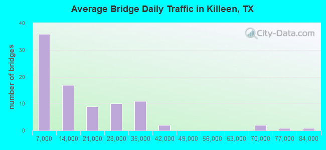
- 1,362,679Total average daily traffic
- 83,855Total average daily truck traffic
- National Bridge Inventory (NBI) Registered Bridges for Killeen
- No street view available for this location
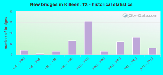
- New bridges - historical statistics
- 41930-1939
- 11940-1949
- 31950-1959
- 131960-1969
- 311970-1979
- 31980-1989
- 121990-1999
- 162000-2009
- 62010-2019
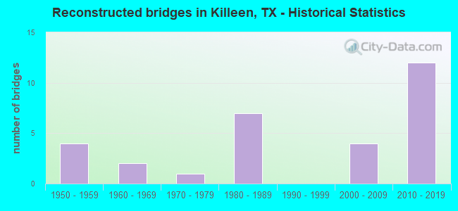
- Reconstructed bridges - Historical Statistics
- 41950-1959
- 21960-1969
- 11970-1979
- 71980-1989
- 01990-1999
- 42000-2009
- 122010-2019
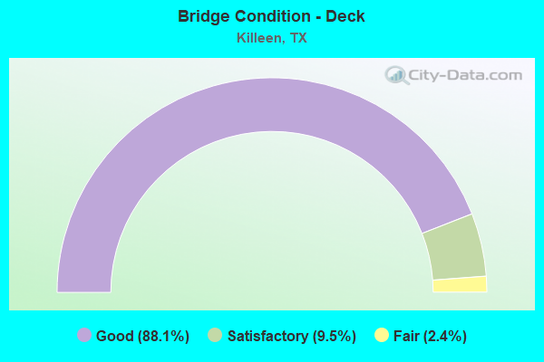
- Bridge Condition - Deck
- 88.1%Good
- 9.5%Satisfactory
- 2.4%Fair
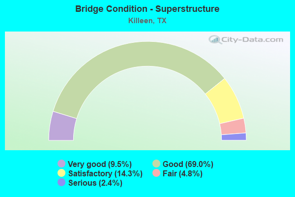
- Bridge Condition - Superstructure
- 9.5%Very good
- 69.0%Good
- 14.3%Satisfactory
- 4.8%Fair
- 2.4%Serious
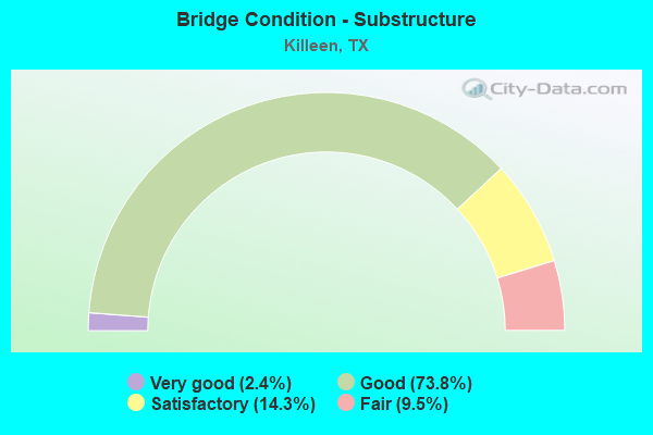
- Bridge Condition - Substructure
- 2.4%Very good
- 73.8%Good
- 14.3%Satisfactory
- 9.5%Fair
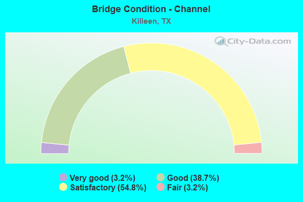
- Bridge Condition - Channel
- 3.2%Very good
- 38.7%Good
- 54.8%Satisfactory
- 3.2%Fair
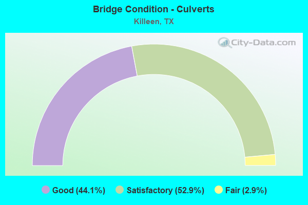
- Bridge Condition - Culverts
- 44.1%Good
- 52.9%Satisfactory
- 2.9%Fair
Find on map >> Show street view
Structure Number: 90140230402008, Location: 0.10 MI S OF INT BU 190 (Lat: 31.097489, Lng: -97.694617), Route carried "on" structure: State highway 2410, Year Built: 1961, Year Reconstructed: 1989, Status: Open, Structure Length: 0.70m (2.30ft), Average Daily Traffic: 21,582 (year 2020), Truck Traffic: 4%, Average Future Daily Traffic: 28,180 (year 2033), Features Intersected: BRANCH OF S NOLAN CREEK
Minimum Vertical Clearance: 30+ m (98+ ft), Kilometerpoint: 6.529, Lanes on structure: 5, Owner: State Highway Agency, Approaching Roadway Width: 23.2m (76.1ft), Skew: 9 degrees, Material/Design: Concrete, Design/Construction: Culvert, Number Of Spans In Main Unit: 3, Length of Maximum Span: 1.8m (5.9ft), Curb-To-Curb Width: 23.5m (77.1ft), Out-to-Out Width: 34.1m (111.9ft)
Condition: Channel: Satisfactory, Culverts: Good, Operating Rating: 39.9 metric tons, Method Used To Determine Operating Rating: Load Factor (LF), Inventory Rating: 23.6 metric tons, Method Used To Determine Inventory Rating: Load Factor (LF), Structural Evaluation: Somewhat better than minimum adequacy, Deck Geometry: Better than present minimum criteria, Waterway Adequacy: Equal to present minimum criteria, Approach Roadway Alignment: Equal to present desirable criteria, Length Of Structure Improvement: 1.83m (6.00ft), Designated Inspection Frequency: Every 24 months, Inspection Date: April 2021, Bridge Improvement Cost: $174,000, Roadway Improvement Cost: $43,000, Total Project Cost: $261,000, Deck Structure Type: Concrete Cast-file-Place, Wearing Surface/Protective System: Wearing Surface: Bituminous
Find on map >> Show street view
Structure Number: 90140230402009, Location: 0.5 MI S OF BU 190 (Lat: 31.090619, Lng: -97.695844), Route carried "on" structure: State highway 2410, Year Built: 1989, Status: Open, Structure Length: 6.40m (21.00ft), Average Daily Traffic: 21,582 (year 2020), Truck Traffic: 4%, Average Future Daily Traffic: 28,180 (year 2033), Design Load: HS 20, Features Intersected: LITTLE NOLAN CREEK
Minimum Vertical Clearance: 30+ m (98+ ft), Kilometerpoint: 7.247, Lanes on structure: 5, Owner: State Highway Agency, Approaching Roadway Width: 25.6m (84.0ft), Skew: 4 degrees, Material/Design: Prestressed concrete, Design/Construction: Stringer/Multi-beam, Number Of Spans In Main Unit: 3, Length of Maximum Span: 21.3m (69.9ft), Curb or Sidewalk Widths: Left: 0.0m, Right: 1.2m (3.9ft), Curb-To-Curb Width: 25.4m (83.3ft), Out-to-Out Width: 27.6m (90.6ft)
Condition: Deck: Good, Superstructure: Good, Substructure: Good, Channel: Satisfactory, Operating Rating: 54.4 metric tons, Method Used To Determine Operating Rating: Assigned rating based on Load Factor Design (LFD) reported in metric tons, Inventory Rating: 32.7 metric tons, Method Used To Determine Inventory Rating: Assigned rating based on Load Factor Design (LFD) reported in metric tons, Structural Evaluation: Better than present minimum criteria, Deck Geometry: Superior to present desirable criteria, Waterway Adequacy: Superior to present desirable criteria, Approach Roadway Alignment: Equal to present desirable criteria, Length Of Structure Improvement: 6.71m (22.01ft), Designated Inspection Frequency: Every 24 months, Inspection Date: April 2021, Bridge Improvement Cost: $783,000, Roadway Improvement Cost: $195,000, Total Project Cost: $1,175,000, Deck Structure Type: Concrete Cast-file-Place, Wearing Surface/Protective System: Wearing Surface: Bituminous
Find on map >> Show street view
Structure Number: 9014023040201, Location: 0.80 MI S OF INT BU 190 (Lat: 31.084492, Lng: -97.697794), Route carried "on" structure: State highway 2410, Year Built: 1961, Year Reconstructed: 1989, Status: Open, Structure Length: 0.70m (2.30ft), Average Daily Traffic: 21,582 (year 2020), Truck Traffic: 4%, Average Future Daily Traffic: 28,180 (year 2033), Features Intersected: BRANCH OF S NOLAN CREEK
Minimum Vertical Clearance: 30+ m (98+ ft), Kilometerpoint: 7.886, Lanes on structure: 5, Owner: State Highway Agency, Approaching Roadway Width: 25.6m (84.0ft), Material/Design: Concrete, Design/Construction: Culvert, Number Of Spans In Main Unit: 4, Length of Maximum Span: 1.5m (4.9ft)
Condition: Channel: Satisfactory, Culverts: Good, Operating Rating: 39.9 metric tons, Method Used To Determine Operating Rating: Load Factor (LF), Inventory Rating: 23.6 metric tons, Method Used To Determine Inventory Rating: Load Factor (LF), Structural Evaluation: Somewhat better than minimum adequacy, Waterway Adequacy: Equal to present minimum criteria, Approach Roadway Alignment: Equal to present desirable criteria, Length Of Structure Improvement: 1.83m (6.00ft), Designated Inspection Frequency: Every 24 months, Inspection Date: April 2021, Bridge Improvement Cost: $174,000, Roadway Improvement Cost: $43,000, Total Project Cost: $261,000
Find on map >> Show street view
Structure Number: 90140239001001, Location: 2.80 MI SE OF SH 195 (Lat: 30.973283, Lng: -97.727436), Route carried "on" structure: State highway 2484, Year Built: 1959, Status: Open, Structure Length: 0.70m (2.30ft), Average Daily Traffic: 2,182 (year 2020), Truck Traffic: 9%, Average Future Daily Traffic: 2,270 (year 2033), Features Intersected: LAMPASAS RIVER TRIB
Minimum Vertical Clearance: 30+ m (98+ ft), Kilometerpoint: 4.480, Lanes on structure: 2, Owner: State Highway Agency, Approaching Roadway Width: 7.9m (25.9ft), Material/Design: Concrete, Design/Construction: Culvert, Number Of Spans In Main Unit: 3, Length of Maximum Span: 2.1m (6.9ft), Curb-To-Curb Width: 7.9m (25.9ft), Out-to-Out Width: 10.8m (35.4ft)
Condition: Channel: Satisfactory, Culverts: Satisfactory, Operating Rating: 39.9 metric tons, Method Used To Determine Operating Rating: Load Factor (LF), Inventory Rating: 23.6 metric tons, Method Used To Determine Inventory Rating: Load Factor (LF), Structural Evaluation: Equal to present minimum criteria, Deck Geometry: High priority of corrective action, Waterway Adequacy: Better than present minimum criteria, Approach Roadway Alignment: Equal to present desirable criteria, Length Of Structure Improvement: 1.83m (6.00ft), Designated Inspection Frequency: Every 24 months, Inspection Date: April 2021, Bridge Improvement Cost: $174,000, Roadway Improvement Cost: $43,000, Total Project Cost: $261,000, Deck Structure Type: Concrete Cast-file-Place, Wearing Surface/Protective System: Wearing Surface: Bituminous
Find on map >> Show street view
Structure Number: 90140315701001, Location: 0.45 MI E OF US 190 (Lat: 31.047683, Lng: -97.318361), Route carried "on" structure: State highway 3117, Year Built: 1969, Status: Open, Structure Length: 1.31m (4.30ft), Average Daily Traffic: 877 (year 2020), Truck Traffic: 11%, Average Future Daily Traffic: 1,390 (year 2035), Design Load: HS 20, Features Intersected: KNOB CREEK
Minimum Vertical Clearance: 30+ m (98+ ft), Kilometerpoint: 0.708, Lanes on structure: 2, Owner: State Highway Agency, Approaching Roadway Width: 7.0m (23.0ft), Material/Design: Concrete, Design/Construction: Culvert, Number Of Spans In Main Unit: 4, Length of Maximum Span: 3.0m (9.8ft), Curb-To-Curb Width: 8.2m (26.9ft), Out-to-Out Width: 11.4m (37.4ft)
Condition: Channel: Satisfactory, Culverts: Satisfactory, Operating Rating: 39.9 metric tons, Method Used To Determine Operating Rating: Load Factor (LF), Inventory Rating: 23.6 metric tons, Method Used To Determine Inventory Rating: Load Factor (LF), Structural Evaluation: Equal to present minimum criteria, Deck Geometry: Somewhat better than minimum adequacy, Waterway Adequacy: Equal to present minimum criteria, Approach Roadway Alignment: Equal to present desirable criteria, Length Of Structure Improvement: 1.83m (6.00ft), Designated Inspection Frequency: Every 24 months, Inspection Date: March 2021, Bridge Improvement Cost: $174,000, Roadway Improvement Cost: $43,000, Total Project Cost: $261,000, Deck Structure Type: Concrete Cast-file-Place, Wearing Surface/Protective System: Wearing Surface: Bituminous
Find on map >> Show street view
Structure Number: 90140340901001, Location: 3.45 MI S OF FM 2410 (Lat: 31.007628, Lng: -97.644997), Route carried "on" structure: State highway 3481, Year Built: 1965, Status: Open, Structure Length: 70.41m (231.00ft), Average Daily Traffic: 3,880 (year 2018), Truck Traffic: 3%, Average Future Daily Traffic: 4,930 (year 2033), Design Load: HS 20, Features Intersected: STILLHOUSE HOLLOW LAKE
Minimum Vertical Clearance: 30+ m (98+ ft), Kilometerpoint: 5.491, Lanes on structure: 2, Owner: State Highway Agency, Approaching Roadway Width: 7.3m (24.0ft), Material/Design: Prestressed concrete, Design/Construction: Stringer/Multi-beam, Number Of Spans In Main Unit: 33, Length of Maximum Span: 21.3m (69.9ft), Curb-To-Curb Width: 7.3m (24.0ft), Out-to-Out Width: 8.9m (29.2ft)
Condition: Deck: Satisfactory, Superstructure: Good, Substructure: Fair, Channel: Satisfactory, Operating Rating: 44.4 metric tons, Method Used To Determine Operating Rating: Allowable Stress (AS), Inventory Rating: 28.1 metric tons, Method Used To Determine Inventory Rating: Allowable Stress (AS), Structural Evaluation: Somewhat better than minimum adequacy, Deck Geometry: High priority of replacement, Waterway Adequacy: Superior to present desirable criteria, Approach Roadway Alignment: Equal to present desirable criteria, Length Of Structure Improvement: 88.00m (288.71ft), Designated Inspection Frequency: Every 24 months, Underwater Inspection Frequency: Every 60 months, Inspection Date: March 2021, Underwater Inspection Date: April 2021, Bridge Improvement Cost: $8,384,000, Roadway Improvement Cost: $2,096,000, Total Project Cost: $12,576,000, Deck Structure Type: Concrete Cast-file-Place
Find on map >> Show street view
Structure Number: 90140340901003, Location: 0.20 MI NW OF FM 2484 (Lat: 30.993447, Lng: -97.636231), Route carried "on" structure: State highway 3481, Year Built: 1997, Status: Open, Structure Length: 0.70m (2.30ft), Average Daily Traffic: 4,697 (year 2020), Truck Traffic: 3%, Average Future Daily Traffic: 4,930 (year 2033), Design Load: HS 20, Features Intersected: TRIB LAMPASAS RIVER
Minimum Vertical Clearance: 30+ m (98+ ft), Kilometerpoint: 5.488, Lanes on structure: 2, Owner: State Highway Agency, Approaching Roadway Width: 14.0m (45.9ft), Skew: 1 degrees, Material/Design: Concrete, Design/Construction: Culvert, Number Of Spans In Main Unit: 2, Length of Maximum Span: 3.0m (9.8ft)
Condition: Channel: Good, Culverts: Good, Operating Rating: 39.9 metric tons, Method Used To Determine Operating Rating: Load Factor (LF), Inventory Rating: 23.6 metric tons, Method Used To Determine Inventory Rating: Load Factor (LF), Structural Evaluation: Equal to present minimum criteria, Waterway Adequacy: Equal to present minimum criteria, Approach Roadway Alignment: Equal to present desirable criteria, Length Of Structure Improvement: 1.83m (6.00ft), Designated Inspection Frequency: Every 48 months, Inspection Date: April 2021, Bridge Improvement Cost: $174,000, Roadway Improvement Cost: $43,000, Total Project Cost: $261,000
Find on map >> Show street view
Structure Number: 90140353401001, Location: 1.69 MI S OF US 190 (Lat: 31.068256, Lng: -97.722322), Route carried "on" structure: State highway 3470, Year Built: 1995, Status: Open, Structure Length: 1.13m (3.71ft), Average Daily Traffic: 19,045 (year 2020), Truck Traffic: 13%, Average Future Daily Traffic: 33,770 (year 2035), Design Load: HS 20, Features Intersected: LITTLE NOLAN CREEK
Minimum Vertical Clearance: 30+ m (98+ ft), Kilometerpoint: 12.080, Lanes on structure: 5, Owner: State Highway Agency, Approaching Roadway Width: 25.6m (84.0ft), Skew: 3 degrees, Material/Design: Concrete, Design/Construction: Culvert, Number Of Spans In Main Unit: 3, Length of Maximum Span: 3.0m (9.8ft)
Condition: Channel: Satisfactory, Culverts: Satisfactory, Operating Rating: 39.9 metric tons, Method Used To Determine Operating Rating: Load Factor (LF), Inventory Rating: 23.6 metric tons, Method Used To Determine Inventory Rating: Load Factor (LF), Structural Evaluation: Somewhat better than minimum adequacy, Waterway Adequacy: Equal to present minimum criteria, Approach Roadway Alignment: Equal to present desirable criteria, Length Of Structure Improvement: 1.83m (6.00ft), Designated Inspection Frequency: Every 48 months, Inspection Date: April 2021, Bridge Improvement Cost: $174,000, Roadway Improvement Cost: $43,000, Total Project Cost: $261,000
Find on map >> Show street view
Structure Number: 90140353401002, Location: 1.69 MI S OF US 190 (Lat: 31.089147, Lng: -97.796711), Route carried "on" structure: State highway 3470, Year Built: 1997, Status: Open, Structure Length: 0.79m (2.59ft), Average Daily Traffic: 19,536 (year 2020), Truck Traffic: 13%, Average Future Daily Traffic: 30,240 (year 2033), Design Load: HS 20, Features Intersected: SOUTH NOLAN CREEK
Minimum Vertical Clearance: 30+ m (98+ ft), Kilometerpoint: 4.620, Lanes on structure: 5, Owner: State Highway Agency, Approaching Roadway Width: 20.1m (65.9ft), Skew: 9 degrees, Material/Design: Concrete, Design/Construction: Culvert, Number Of Spans In Main Unit: 3, Length of Maximum Span: 2.4m (7.9ft)
Condition: Channel: Satisfactory, Culverts: Good, Operating Rating: 39.9 metric tons, Method Used To Determine Operating Rating: Load Factor (LF), Inventory Rating: 23.6 metric tons, Method Used To Determine Inventory Rating: Load Factor (LF), Structural Evaluation: Somewhat better than minimum adequacy, Waterway Adequacy: Equal to present minimum criteria, Approach Roadway Alignment: Equal to present desirable criteria, Length Of Structure Improvement: 1.83m (6.00ft), Designated Inspection Frequency: Every 48 months, Inspection Date: April 2021, Bridge Improvement Cost: $174,000, Roadway Improvement Cost: $43,000, Total Project Cost: $261,000
Find on map >> Show street view
Structure Number: 90140353402004, Location: 2.10 MI W OF SH 195 (Lat: 31.058000, Lng: -97.801397), Route carried "on" structure: State highway 201, Year Built: 2004, Status: Open, Structure Length: 3.81m (12.50ft), Average Daily Traffic: 11,779 (year 2020), Truck Traffic: 13%, Average Future Daily Traffic: 10,320 (year 2033), Design Load: HS 25 or greater, Features Intersected: NORTH REESE CREEK
Minimum Vertical Clearance: 30+ m (98+ ft), Kilometerpoint: 3.380, Lanes on structure: 4, Owner: State Highway Agency, Approaching Roadway Width: 23.8m (78.1ft), Skew: 20 degrees, Material/Design: Prestressed concrete, Design/Construction: Stringer/Multi-beam, Number Of Spans In Main Unit: 1, Length of Maximum Span: 37.8m (124.0ft), Curb-To-Curb Width: 24.0m (78.7ft), Out-to-Out Width: 31.7m (104.0ft)
Condition: Deck: Good, Superstructure: Satisfactory, Substructure: Good, Channel: Good, Operating Rating: 68.0 metric tons, Method Used To Determine Operating Rating: Assigned ratings based on Load and Resistance Factor Design (LRFD) reported in metric tons, Inventory Rating: 40.8 metric tons, Method Used To Determine Inventory Rating: Assigned ratings based on Load and Resistance Factor Design (LRFD) reported in metric tons, Structural Evaluation: Equal to present minimum criteria, Deck Geometry: Superior to present desirable criteria, Waterway Adequacy: Superior to present desirable criteria, Approach Roadway Alignment: Equal to present desirable criteria, Designated Inspection Frequency: Every 24 months, Inspection Date: April 2021, Deck Structure Type: Concrete Precast Panels
Find on map >> Show street view
Structure Number: 90140353402005, Location: 1.00 MI W OF SH 195 (Lat: 31.055328, Lng: -97.782561), Route carried "on" structure: State highway 201, Year Built: 2004, Status: Open, Structure Length: 3.81m (12.50ft), Average Daily Traffic: 11,779 (year 2020), Truck Traffic: 13%, Average Future Daily Traffic: 10,320 (year 2035), Design Load: HS 25 or greater, Features Intersected: NORTH REESE CREEK
Minimum Vertical Clearance: 30+ m (98+ ft), Kilometerpoint: 1.609, Lanes on structure: 4, Owner: State Highway Agency, Approaching Roadway Width: 23.8m (78.1ft), Skew: 20 degrees, Material/Design: Prestressed concrete, Design/Construction: Stringer/Multi-beam, Number Of Spans In Main Unit: 1, Length of Maximum Span: 37.8m (124.0ft), Curb-To-Curb Width: 24.1m (79.1ft), Out-to-Out Width: 31.7m (104.0ft)
Condition: Deck: Good, Superstructure: Good, Substructure: Good, Channel: Good, Operating Rating: 68.0 metric tons, Method Used To Determine Operating Rating: Assigned ratings based on Load and Resistance Factor Design (LRFD) reported in metric tons, Inventory Rating: 40.8 metric tons, Method Used To Determine Inventory Rating: Assigned ratings based on Load and Resistance Factor Design (LRFD) reported in metric tons, Structural Evaluation: Better than present minimum criteria, Deck Geometry: Superior to present desirable criteria, Waterway Adequacy: Superior to present desirable criteria, Approach Roadway Alignment: Equal to present desirable criteria, Designated Inspection Frequency: Every 24 months, Inspection Date: April 2021, Deck Structure Type: Concrete Precast Panels
Find on map >> Show street view
Structure Number: 90140353402006, Location: 0.40 MI W OF SH 195 (Lat: 31.056139, Lng: -97.772114), Route carried "on" structure: State highway 201, Year Built: 2004, Status: Open, Structure Length: 3.81m (12.50ft), Average Daily Traffic: 11,779 (year 2020), Truck Traffic: 13%, Average Future Daily Traffic: 10,320 (year 2035), Design Load: HS 25 or greater, Features Intersected: NORTH REESE CREEK
Minimum Vertical Clearance: 30+ m (98+ ft), Kilometerpoint: 0.644, Lanes on structure: 6, Owner: State Highway Agency, Approaching Roadway Width: 30.2m (99.1ft), Skew: 20 degrees, Material/Design: Prestressed concrete, Design/Construction: Stringer/Multi-beam, Number Of Spans In Main Unit: 1, Length of Maximum Span: 37.8m (124.0ft), Curb-To-Curb Width: 30.2m (99.1ft), Out-to-Out Width: 31.7m (104.0ft)
Condition: Deck: Good, Superstructure: Very good, Substructure: Good, Channel: Good, Operating Rating: 68.0 metric tons, Method Used To Determine Operating Rating: Assigned ratings based on Load and Resistance Factor Design (LRFD) reported in metric tons, Inventory Rating: 40.8 metric tons, Method Used To Determine Inventory Rating: Assigned ratings based on Load and Resistance Factor Design (LRFD) reported in metric tons, Structural Evaluation: Better than present minimum criteria, Deck Geometry: Superior to present desirable criteria, Waterway Adequacy: Superior to present desirable criteria, Approach Roadway Alignment: Equal to present desirable criteria, Designated Inspection Frequency: Every 24 months, Inspection Date: April 2021, Deck Structure Type: Concrete Precast Panels
Find on map >> Show street view
Structure Number: 90140AA6035001, Location: 0.60 MI NW CHAPARRAL RD (Lat: 31.037253, Lng: -97.694828), Route carried "on" structure: County highway , Year Built: 1990, Status: Open, Structure Length: 1.31m (4.30ft), Average Daily Traffic: 2,625 (year 2020), Truck Traffic: 2%, Average Future Daily Traffic: 1,000 (year 2033), Features Intersected: TRIMMIER CRK BR # 650, Facility Carried by Structure: E TRIMMIER RD
Minimum Vertical Clearance: 30+ m (98+ ft), Kilometerpoint: 1.851, Lanes on structure: 2, Owner: County Highway Agency, Approaching Roadway Width: 6.4m (21.0ft), Material/Design: Concrete, Design/Construction: Culvert, Number Of Spans In Main Unit: 4, Length of Maximum Span: 3.0m (9.8ft), Curb-To-Curb Width: 6.4m (21.0ft), Out-to-Out Width: 10.8m (35.4ft)
Condition: Channel: Satisfactory, Culverts: Satisfactory, Operating Rating: 32.7 metric tons, Method Used To Determine Operating Rating: Field evaluation and documented engineering judgment, Inventory Rating: 24.5 metric tons, Method Used To Determine Inventory Rating: Field evaluation and documented engineering judgment, Structural Evaluation: Equal to present minimum criteria, Deck Geometry: High priority of replacement, Waterway Adequacy: Better than present minimum criteria, Approach Roadway Alignment: Equal to present desirable criteria, Length Of Structure Improvement: 1.31m (4.30ft), Designated Inspection Frequency: Every 24 months, Inspection Date: November 2021, Bridge Improvement Cost: $2,000, Roadway Improvement Cost: $1,000, Total Project Cost: $3,000, Deck Structure Type: Concrete Cast-file-Place, Wearing Surface/Protective System: Wearing Surface: Bituminous
Find on map >> Show street view
Structure Number: 90140AA7009001, Location: 0.70 MI N OF LONG MEADOW (Lat: 30.938006, Lng: -97.604500), Route carried "on" structure: County highway , Year Built: 2004, Status: Open, Structure Length: 3.66m (12.01ft), Average Daily Traffic: 586 (year 2020), Average Future Daily Traffic: 175 (year 2033), Design Load: HS 20, Features Intersected: MUSTANG CREEK #72, Facility Carried by Structure: MISSION TRAIL
Minimum Vertical Clearance: 30+ m (98+ ft), Kilometerpoint: 0.002, Lanes on structure: 2, Owner: County Highway Agency, Approaching Roadway Width: 7.3m (24.0ft), Material/Design: Concrete, Design/Construction: Stringer/Multi-beam, Number Of Spans In Main Unit: 3, Length of Maximum Span: 12.2m (40.0ft), Curb-To-Curb Width: 7.8m (25.6ft), Out-to-Out Width: 8.5m (27.9ft)
Condition: Deck: Good, Superstructure: Good, Substructure: Good, Channel: Good, Operating Rating: 68.0 metric tons, Method Used To Determine Operating Rating: Load Factor (LF), Inventory Rating: 40.8 metric tons, Method Used To Determine Inventory Rating: Load Factor (LF), Structural Evaluation: Better than present minimum criteria, Deck Geometry: Meets minimum limits, Waterway Adequacy: Better than present minimum criteria, Approach Roadway Alignment: Equal to present desirable criteria, Designated Inspection Frequency: Every 24 months, Inspection Date: November 2021, Deck Structure Type: Concrete Cast-file-Place
Find on map >> Show street view
Structure Number: 90140C00102001, Location: 0.10 MI S OF US 190 BU (Lat: 31.115592, Lng: -97.731792), Route carried "on" structure: City street , Year Built: 1961, Year Reconstructed: 1985, Status: Open, Structure Length: 4.63m (15.19ft), Average Daily Traffic: 5,150 (year 2020), Truck Traffic: 2%, Average Future Daily Traffic: 12,550 (year 2033), Design Load: H 20, Features Intersected: S NOLAN CRK #3 KIL, Facility Carried by Structure: S 2ND ST
Minimum Vertical Clearance: 30+ m (98+ ft), Kilometerpoint: 1.931, Lanes on structure: 2, Owner: City or Municipal Highway Agency, Approaching Roadway Width: 12.8m (42.0ft), Material/Design: Concrete, Design/Construction: Stringer/Multi-beam, Number Of Spans In Main Unit: 5, Length of Maximum Span: 9.1m (29.9ft), Curb or Sidewalk Widths: Left: 1.2m (3.9ft), Right: 1.2m (3.9ft), Curb-To-Curb Width: 13.7m (44.9ft), Out-to-Out Width: 17.5m (57.4ft)
Condition: Deck: Good, Superstructure: Good, Substructure: Good, Channel: Satisfactory, Operating Rating: 58.0 metric tons, Method Used To Determine Operating Rating: Load Factor (LF), Inventory Rating: 35.4 metric tons, Method Used To Determine Inventory Rating: Load Factor (LF), Structural Evaluation: Better than present minimum criteria, Deck Geometry: Superior to present desirable criteria, Waterway Adequacy: Equal to present minimum criteria, Approach Roadway Alignment: Equal to present desirable criteria, Length Of Structure Improvement: 6.40m (21.00ft), Designated Inspection Frequency: Every 24 months, Inspection Date: November 2021, Bridge Improvement Cost: $586,000, Roadway Improvement Cost: $147,000, Total Project Cost: $733,000, Deck Structure Type: Concrete Cast-file-Place, Wearing Surface/Protective System: Wearing Surface: Bituminous
Find on map >> Show street view
Structure Number: 90140C00110001, Location: 0.20 MI S OF US 190 BU (Lat: 31.113389, Lng: -97.727794), Route carried "on" structure: City street , Year Built: 1961, Status: Open, Structure Length: 4.63m (15.19ft), Average Daily Traffic: 6,843 (year 2020), Truck Traffic: 2%, Average Future Daily Traffic: 10,500 (year 2033), Design Load: H 20, Features Intersected: S NOLAN CRK #5 KIL, Facility Carried by Structure: S 10TH ST
Minimum Vertical Clearance: 30+ m (98+ ft), Kilometerpoint: 2.092, Lanes on structure: 2, Owner: City or Municipal Highway Agency, Approaching Roadway Width: 8.5m (27.9ft), Material/Design: Concrete, Design/Construction: Stringer/Multi-beam, Number Of Spans In Main Unit: 5, Length of Maximum Span: 9.1m (29.9ft), Curb-To-Curb Width: 8.5m (27.9ft), Out-to-Out Width: 9.5m (31.2ft)
Condition: Deck: Satisfactory, Superstructure: Satisfactory, Substructure: Satisfactory, Channel: Good, Operating Rating: 63.5 metric tons, Method Used To Determine Operating Rating: Load Factor (LF), Inventory Rating: 38.1 metric tons, Method Used To Determine Inventory Rating: Load Factor (LF), Structural Evaluation: Equal to present minimum criteria, Deck Geometry: High priority of replacement, Waterway Adequacy: Equal to present minimum criteria, Approach Roadway Alignment: Equal to present desirable criteria, Length Of Structure Improvement: 6.40m (21.00ft), Designated Inspection Frequency: Every 24 months, Inspection Date: November 2021, Bridge Improvement Cost: $586,000, Roadway Improvement Cost: $147,000, Total Project Cost: $733,000, Deck Structure Type: Concrete Cast-file-Place
Find on map >> Show street view
Structure Number: 90140C00130001, Location: 0.20 MI N OF US 190 BU (Lat: 31.113675, Lng: -97.712117), Route carried "on" structure: City street , Year Built: 1975, Status: Open, Structure Length: 21.43m (70.31ft), Average Daily Traffic: 12,186 (year 2020), Average Future Daily Traffic: 19,000 (year 2033), Features Intersected: BNSF RR/S NOLAN CK #6KIL, Facility Carried by Structure: W S YOUNG DR
Minimum Vertical Clearance: 30+ m (98+ ft), Kilometerpoint: 2.977, Lanes on structure: 4, Owner: City or Municipal Highway Agency, Approaching Roadway Width: 14.6m (47.9ft), Skew: 20 degrees, Material/Design: Prestressed concrete, Design/Construction: Stringer/Multi-beam, Number Of Spans In Main Unit: 10, Length of Maximum Span: 21.3m (69.9ft), Curb or Sidewalk Widths: Left: 1.0m (3.3ft), Right: 0.0m, Curb-To-Curb Width: 14.6m (47.9ft), Out-to-Out Width: 18.0m (59.1ft)
Condition: Deck: Good, Superstructure: Good, Substructure: Good, Channel: Satisfactory, Operating Rating: 32.7 metric tons, Method Used To Determine Operating Rating: Field evaluation and documented engineering judgment, Inventory Rating: 24.5 metric tons, Method Used To Determine Inventory Rating: Field evaluation and documented engineering judgment, Structural Evaluation: Equal to present minimum criteria, Deck Geometry: High priority of replacement, Underclear: Equal to present minimum criteria, Waterway Adequacy: Superior to present desirable criteria, Approach Roadway Alignment: Equal to present desirable criteria, Length Of Structure Improvement: 26.79m (87.89ft), Designated Inspection Frequency: Every 24 months, Inspection Date: November 2021, Bridge Improvement Cost: $2,455,000, Roadway Improvement Cost: $614,000, Total Project Cost: $3,069,000, Deck Structure Type: Concrete Cast-file-Place
Find on map >> Show street view
Structure Number: 90140C00130002, Location: 0.10 MI S OF US 190 (Lat: 31.088997, Lng: -97.720364), Route carried "on" structure: City street , Year Built: 1975, Year Reconstructed: 2006, Status: Open, Structure Length: 1.34m (4.40ft), Average Daily Traffic: 30,132 (year 2020), Truck Traffic: 2%, Average Future Daily Traffic: 23,000 (year 2033), Features Intersected: LTL NOLAN CRK BR #10 KIL, Facility Carried by Structure: W S YOUNG DR
Minimum Vertical Clearance: 30+ m (98+ ft), Kilometerpoint: 5.955, Lanes on structure: 6, Owner: City or Municipal Highway Agency, Approaching Roadway Width: 19.5m (64.0ft), Material/Design: Concrete, Design/Construction: Culvert, Number Of Spans In Main Unit: 4, Length of Maximum Span: 3.0m (9.8ft), Curb or Sidewalk Widths: Left: 1.9m (6.2ft), Right: 2.1m (6.9ft), Curb-To-Curb Width: 23.4m (76.8ft), Out-to-Out Width: 28.4m (93.2ft)
Condition: Channel: Satisfactory, Culverts: Good, Operating Rating: 32.7 metric tons, Method Used To Determine Operating Rating: Field evaluation and documented engineering judgment, Inventory Rating: 24.5 metric tons, Method Used To Determine Inventory Rating: Field evaluation and documented engineering judgment, Structural Evaluation: Equal to present minimum criteria, Deck Geometry: Somewhat better than minimum adequacy, Waterway Adequacy: Equal to present minimum criteria, Approach Roadway Alignment: Equal to present desirable criteria, Length Of Structure Improvement: 1.83m (6.00ft), Designated Inspection Frequency: Every 24 months, Inspection Date: November 2021, Bridge Improvement Cost: $167,000, Roadway Improvement Cost: $41,000, Total Project Cost: $208,000, Deck Structure Type: Concrete Cast-file-Place, Wearing Surface/Protective System: Wearing Surface: Bituminous
Find on map >> Show street view
Structure Number: 90140C00130003, Location: 0.15 MI S OF ELMS RD (Lat: 31.075042, Lng: -97.725000), Route carried "on" structure: City street , Year Built: 2002, Status: Open, Structure Length: 1.52m (4.99ft), Average Daily Traffic: 1,040 (year 2013), Truck Traffic: 1%, Average Future Daily Traffic: 2,000 (year 2033), Design Load: HS 20, Features Intersected: NOLAN CRK TRIB #14 KIL, Facility Carried by Structure: W S YOUNG DR
Minimum Vertical Clearance: 30+ m (98+ ft), Kilometerpoint: 0.241, Lanes on structure: 5, Owner: City or Municipal Highway Agency, Approaching Roadway Width: 19.5m (64.0ft), Skew: 3 degrees, Material/Design: Concrete, Design/Construction: Culvert, Number Of Spans In Main Unit: 5, Length of Maximum Span: 2.4m (7.9ft), Curb-To-Curb Width: 19.7m (64.6ft), Out-to-Out Width: 22.6m (74.1ft)
Condition: Channel: Satisfactory, Culverts: Satisfactory, Operating Rating: 54.4 metric tons, Method Used To Determine Operating Rating: Assigned rating based on Load Factor Design (LFD) reported in metric tons, Inventory Rating: 32.7 metric tons, Method Used To Determine Inventory Rating: Assigned rating based on Load Factor Design (LFD) reported in metric tons, Structural Evaluation: Equal to present minimum criteria, Deck Geometry: Meets minimum limits, Waterway Adequacy: Equal to present minimum criteria, Approach Roadway Alignment: Equal to present desirable criteria, Designated Inspection Frequency: Every 24 months, Inspection Date: November 2021, Deck Structure Type: Concrete Cast-file-Place, Wearing Surface/Protective System: Wearing Surface: Bituminous
Find on map >> Show street view
Structure Number: 90140C00221001, Location: 2.50 MI E OF SH 195 (Lat: 31.074647, Lng: -97.714847), Route carried "on" structure: City street , Year Built: 1975, Year Reconstructed: 1993, Status: Open, Structure Length: 0.82m (2.69ft), Average Daily Traffic: 7,820 (year 2020), Truck Traffic: 2%, Average Future Daily Traffic: 13,000 (year 2033), Features Intersected: LITTLE NOLAN CRK #12 KIL, Facility Carried by Structure: E ELMS RD
Minimum Vertical Clearance: 30+ m (98+ ft), Kilometerpoint: 4.023, Lanes on structure: 5, Owner: City or Municipal Highway Agency, Approaching Roadway Width: 20.1m (65.9ft), Skew: 9 degrees, Material/Design: Concrete, Design/Construction: Culvert, Number Of Spans In Main Unit: 3, Length of Maximum Span: 2.4m (7.9ft)
Condition: Channel: Satisfactory, Culverts: Satisfactory, Operating Rating: 32.7 metric tons, Method Used To Determine Operating Rating: Field evaluation and documented engineering judgment, Inventory Rating: 24.5 metric tons, Method Used To Determine Inventory Rating: Field evaluation and documented engineering judgment, Structural Evaluation: Equal to present minimum criteria, Waterway Adequacy: Equal to present minimum criteria, Approach Roadway Alignment: Equal to present desirable criteria, Length Of Structure Improvement: 1.83m (6.00ft), Designated Inspection Frequency: Every 24 months, Inspection Date: November 2021, Bridge Improvement Cost: $167,000, Roadway Improvement Cost: $41,000, Total Project Cost: $208,000
Find on map >> Show street view
Structure Number: 90140C00221002, Location: 0.01 MI W OF ROBINETT RD (Lat: 31.098083, Lng: -97.786847), Route carried "on" structure: City street , Year Built: 2000, Status: Open, Structure Length: 1.07m (3.51ft), Average Daily Traffic: 200 (year 2013), Truck Traffic: 1%, Average Future Daily Traffic: 300 (year 2033), Design Load: HS 20, Features Intersected: S NOLAN CRK TRIB #19 KIL, Facility Carried by Structure: W ELMS RD
Minimum Vertical Clearance: 30+ m (98+ ft), Kilometerpoint: 0.016, Lanes on structure: 5, Owner: City or Municipal Highway Agency, Approaching Roadway Width: 19.8m (65.0ft), Material/Design: Concrete, Design/Construction: Culvert, Number Of Spans In Main Unit: 4, Length of Maximum Span: 2.4m (7.9ft), Curb or Sidewalk Widths: Left: 1.3m (4.3ft), Right: 1.5m (4.9ft), Curb-To-Curb Width: 19.8m (65.0ft), Out-to-Out Width: 28.3m (92.8ft)
Condition: Channel: Good, Culverts: Good, Operating Rating: 54.4 metric tons, Method Used To Determine Operating Rating: Assigned rating based on Load Factor Design (LFD) reported in metric tons, Inventory Rating: 32.7 metric tons, Method Used To Determine Inventory Rating: Assigned rating based on Load Factor Design (LFD) reported in metric tons, Structural Evaluation: Better than present minimum criteria, Deck Geometry: Meets minimum limits, Waterway Adequacy: Better than present minimum criteria, Approach Roadway Alignment: Equal to present desirable criteria, Designated Inspection Frequency: Every 24 months, Inspection Date: November 2021, Deck Structure Type: Concrete Cast-file-Place, Wearing Surface/Protective System: Wearing Surface: Bituminous
Find on map >> Show street view
Structure Number: 90140C00221003, Location: 0.35 MI W OF TALLWOOD DR (Lat: 31.092533, Lng: -97.774306), Route carried "on" structure: City street , Year Built: 1995, Status: Open, Structure Length: 0.94m (3.08ft), Average Daily Traffic: 400 (year 2013), Truck Traffic: 1%, Average Future Daily Traffic: 600 (year 2033), Features Intersected: DRAW #20 KIL, Facility Carried by Structure: W ELMS RD
Minimum Vertical Clearance: 30+ m (98+ ft), Kilometerpoint: 0.563, Lanes on structure: 5, Owner: City or Municipal Highway Agency, Approaching Roadway Width: 19.8m (65.0ft), Material/Design: Concrete, Design/Construction: Culvert, Number Of Spans In Main Unit: 4, Length of Maximum Span: 2.1m (6.9ft), Curb or Sidewalk Widths: Left: 1.2m (3.9ft), Right: 1.2m (3.9ft), Curb-To-Curb Width: 19.8m (65.0ft), Out-to-Out Width: 26.8m (87.9ft)
Condition: Channel: Good, Culverts: Good, Operating Rating: 32.7 metric tons, Method Used To Determine Operating Rating: Field evaluation and documented engineering judgment, Inventory Rating: 24.5 metric tons, Method Used To Determine Inventory Rating: Field evaluation and documented engineering judgment, Structural Evaluation: Equal to present minimum criteria, Deck Geometry: Meets minimum limits, Waterway Adequacy: Better than present minimum criteria, Approach Roadway Alignment: Equal to present desirable criteria, Designated Inspection Frequency: Every 24 months, Inspection Date: November 2021, Deck Structure Type: Concrete Cast-file-Place, Wearing Surface/Protective System: Wearing Surface: Bituminous
Find on map >> Show street view
Structure Number: 90140C00251001, Location: 0.50 MI E OF 38TH ST (Lat: 31.121708, Lng: -97.688481), Route carried "on" structure: City street , Year Built: 1948, Year Reconstructed: 1985, Status: Open, Structure Length: 2.35m (7.71ft), Average Daily Traffic: 4,471 (year 2020), Truck Traffic: 2%, Average Future Daily Traffic: 6,000 (year 2033), Features Intersected: LONG BR # 1 KIL, Facility Carried by Structure: LAKE RD
Minimum Vertical Clearance: 30+ m (98+ ft), Kilometerpoint: 0.805, Lanes on structure: 2, Owner: City or Municipal Highway Agency, Approaching Roadway Width: 14.0m (45.9ft), Material/Design: Concrete, Design/Construction: Slab, Number Of Spans In Main Unit: 3, Length of Maximum Span: 7.6m (24.9ft), Curb or Sidewalk Widths: Left: 0.8m (2.6ft), Right: 0.8m (2.6ft), Curb-To-Curb Width: 14.3m (46.9ft), Out-to-Out Width: 16.5m (54.1ft)
Condition: Deck: Satisfactory, Superstructure: Satisfactory, Substructure: Satisfactory, Channel: Satisfactory, Operating Rating: 32.7 metric tons, Method Used To Determine Operating Rating: Field evaluation and documented engineering judgment, Inventory Rating: 24.5 metric tons, Method Used To Determine Inventory Rating: Field evaluation and documented engineering judgment, Structural Evaluation: Equal to present minimum criteria, Deck Geometry: Superior to present desirable criteria, Waterway Adequacy: Equal to present minimum criteria, Approach Roadway Alignment: Equal to present desirable criteria, Length Of Structure Improvement: 3.05m (10.01ft), Designated Inspection Frequency: Every 24 months, Inspection Date: November 2021, Bridge Improvement Cost: $279,000, Roadway Improvement Cost: $70,000, Total Project Cost: $349,000, Deck Structure Type: Concrete Cast-file-Place
Find on map >> Show street view
Structure Number: 90140C00528001, Location: 0.20 MI N OF US 190 BU (Lat: 31.113572, Lng: -97.718286), Route carried "on" structure: City street , Year Built: 1979, Status: Open, Structure Length: 3.72m (12.20ft), Average Daily Traffic: 10,000 (year 2013), Average Future Daily Traffic: 11,000 (year 2033), Features Intersected: S NOLAN CRK #7 KIL, Facility Carried by Structure: S 28TH ST
Minimum Vertical Clearance: 30+ m (98+ ft), Kilometerpoint: 0.322, Lanes on structure: 2, Owner: City or Municipal Highway Agency, Approaching Roadway Width: 14.0m (45.9ft), Material/Design: Concrete, Design/Construction: Stringer/Multi-beam, Number Of Spans In Main Unit: 3, Length of Maximum Span: 12.2m (40.0ft), Curb or Sidewalk Widths: Left: 1.1m (3.6ft), Right: 1.1m (3.6ft), Curb-To-Curb Width: 14.3m (46.9ft), Out-to-Out Width: 17.1m (56.1ft)
Condition: Deck: Good, Superstructure: Good, Substructure: Fair, Channel: Good, Operating Rating: 32.7 metric tons, Method Used To Determine Operating Rating: Field evaluation and documented engineering judgment, Inventory Rating: 24.5 metric tons, Method Used To Determine Inventory Rating: Field evaluation and documented engineering judgment, Structural Evaluation: Somewhat better than minimum adequacy, Deck Geometry: Superior to present desirable criteria, Waterway Adequacy: Equal to present minimum criteria, Approach Roadway Alignment: Equal to present desirable criteria, Length Of Structure Improvement: 4.57m (14.99ft), Designated Inspection Frequency: Every 24 months, Inspection Date: November 2021, Bridge Improvement Cost: $419,000, Roadway Improvement Cost: $104,000, Total Project Cost: $523,000, Deck Structure Type: Concrete Cast-file-Place
Find on map >> Show street view
Structure Number: 90140C01140001, Location: 0.15 MI S OF US 190 BU (Lat: 31.117583, Lng: -97.740053), Route carried "on" structure: City street , Year Built: 1961, Status: Open, Structure Length: 4.63m (15.19ft), Average Daily Traffic: 2,679 (year 2020), Truck Traffic: 1%, Average Future Daily Traffic: 3,500 (year 2033), Design Load: H 20, Features Intersected: S NOLAN CRK #2 KIL, Facility Carried by Structure: DIMPLE ST
Minimum Vertical Clearance: 30+ m (98+ ft), Kilometerpoint: 0.241, Lanes on structure: 2, Owner: City or Municipal Highway Agency, Approaching Roadway Width: 7.9m (25.9ft), Material/Design: Concrete, Design/Construction: Stringer/Multi-beam, Number Of Spans In Main Unit: 5, Length of Maximum Span: 9.1m (29.9ft), Curb-To-Curb Width: 8.5m (27.9ft), Out-to-Out Width: 9.4m (30.8ft)
Condition: Deck: Fair, Superstructure: Fair, Substructure: Fair, Channel: Satisfactory, Operating Rating: 63.5 metric tons, Method Used To Determine Operating Rating: Load Factor (LF), Inventory Rating: 38.1 metric tons, Method Used To Determine Inventory Rating: Load Factor (LF), Structural Evaluation: Somewhat better than minimum adequacy, Deck Geometry: Meets minimum limits, Waterway Adequacy: Equal to present minimum criteria, Approach Roadway Alignment: Equal to present desirable criteria, Length Of Structure Improvement: 6.40m (21.00ft), Designated Inspection Frequency: Every 24 months, Inspection Date: November 2021, Bridge Improvement Cost: $586,000, Roadway Improvement Cost: $147,000, Total Project Cost: $733,000, Deck Structure Type: Concrete Cast-file-Place
Find on map >> Show street view
Structure Number: 90140C01310001, Location: 0.50 MI S OF US 190 (Lat: 31.084722, Lng: -97.745556), Route carried "on" structure: City street , Year Built: 1970, Status: Open, Structure Length: 1.19m (3.90ft), Average Daily Traffic: 4,208 (year 2020), Truck Traffic: 2%, Average Future Daily Traffic: 6,000 (year 2033), Features Intersected: LTL NOLAN CRK BR #8 KIL, Facility Carried by Structure: FLORENCE RD
Minimum Vertical Clearance: 30+ m (98+ ft), Kilometerpoint: 0.805, Lanes on structure: 3, Owner: City or Municipal Highway Agency, Approaching Roadway Width: 12.8m (42.0ft), Material/Design: Concrete, Design/Construction: Culvert, Number Of Spans In Main Unit: 6, Length of Maximum Span: 1.8m (5.9ft), Curb or Sidewalk Widths: Left: 0.0m, Right: 1.1m (3.6ft), Curb-To-Curb Width: 13.0m (42.7ft), Out-to-Out Width: 17.5m (57.4ft)
Condition: Channel: Fair, Culverts: Satisfactory, Operating Rating: 32.7 metric tons, Method Used To Determine Operating Rating: Field evaluation and documented engineering judgment, Inventory Rating: 24.5 metric tons, Method Used To Determine Inventory Rating: Field evaluation and documented engineering judgment, Structural Evaluation: Equal to present minimum criteria, Deck Geometry: Meets minimum limits, Waterway Adequacy: High priority of corrective action, Approach Roadway Alignment: Equal to present desirable criteria, Length Of Structure Improvement: 1.83m (6.00ft), Designated Inspection Frequency: Every 24 months, Inspection Date: November 2021, Bridge Improvement Cost: $167,000, Roadway Improvement Cost: $41,000, Total Project Cost: $208,000, Deck Structure Type: Concrete Cast-file-Place, Wearing Surface/Protective System: Wearing Surface: Bituminous
Find on map >> Show street view
Structure Number: 90140C01367001, Location: 0.20 MI S OF US 190 (Lat: 31.093303, Lng: -97.736275), Route carried "on" structure: City street , Year Built: 2000, Status: Open, Structure Length: 2.62m (8.60ft), Average Daily Traffic: 250 (year 2013), Truck Traffic: 1%, Average Future Daily Traffic: 350 (year 2033), Features Intersected: NOLAN CRK TRIB #22 KIL, Facility Carried by Structure: GATEWAY DR
Minimum Vertical Clearance: 30+ m (98+ ft), Kilometerpoint: 0.322, Lanes on structure: 2, Owner: City or Municipal Highway Agency, Approaching Roadway Width: 9.1m (29.9ft), Material/Design: Concrete, Design/Construction: Culvert, Number Of Spans In Main Unit: 8, Length of Maximum Span: 3.0m (9.8ft), Curb-To-Curb Width: 9.1m (29.9ft), Out-to-Out Width: 14.6m (47.9ft)
Condition: Channel: Good, Culverts: Satisfactory, Operating Rating: 32.7 metric tons, Method Used To Determine Operating Rating: Field evaluation and documented engineering judgment, Inventory Rating: 24.5 metric tons, Method Used To Determine Inventory Rating: Field evaluation and documented engineering judgment, Structural Evaluation: Equal to present minimum criteria, Deck Geometry: Equal to present minimum criteria, Waterway Adequacy: Equal to present minimum criteria, Approach Roadway Alignment: Equal to present desirable criteria, Designated Inspection Frequency: Every 24 months, Inspection Date: November 2021, Deck Structure Type: Concrete Cast-file-Place, Wearing Surface/Protective System: Wearing Surface: Bituminous
Find on map >> Show street view
Structure Number: 90140C01435001, Location: 0.10 MI S OF US 190 BU (Lat: 31.115300, Lng: -97.729500), Route carried "on" structure: City street , Year Built: 1990, Status: Open, Structure Length: 4.63m (15.19ft), Average Daily Traffic: 1,599 (year 2020), Truck Traffic: 2%, Average Future Daily Traffic: 6,450 (year 2033), Design Load: HS 20, Features Intersected: S NOLAN CRK #4 KIL, Facility Carried by Structure: S GRAY ST
Minimum Vertical Clearance: 30+ m (98+ ft), Kilometerpoint: 1.931, Lanes on structure: 2, Owner: City or Municipal Highway Agency, Approaching Roadway Width: 10.4m (34.1ft), Material/Design: Concrete, Design/Construction: Stringer/Multi-beam, Number Of Spans In Main Unit: 5, Length of Maximum Span: 9.1m (29.9ft), Curb or Sidewalk Widths: Left: 1.9m (6.2ft), Right: 1.9m (6.2ft), Curb-To-Curb Width: 14.9m (48.9ft), Out-to-Out Width: 19.3m (63.3ft)
Condition: Deck: Good, Superstructure: Good, Substructure: Good, Channel: Good, Operating Rating: 68.0 metric tons, Method Used To Determine Operating Rating: Load Factor (LF), Inventory Rating: 40.8 metric tons, Method Used To Determine Inventory Rating: Load Factor (LF), Structural Evaluation: Better than present minimum criteria, Deck Geometry: Superior to present desirable criteria, Waterway Adequacy: Equal to present minimum criteria, Approach Roadway Alignment: Equal to present desirable criteria, Length Of Structure Improvement: 6.40m (21.00ft), Designated Inspection Frequency: Every 24 months, Inspection Date: November 2021, Bridge Improvement Cost: $586,000, Roadway Improvement Cost: $147,000, Total Project Cost: $733,000, Deck Structure Type: Concrete Cast-file-Place, Wearing Surface/Protective System: Wearing Surface: Bituminous
Find on map >> Show street view
Structure Number: 90140C02392001, Location: 0.85 MI N OF FM 3470 (Lat: 31.099778, Lng: -97.785944), Route carried "on" structure: City street , Year Built: 2000, Status: Open, Structure Length: 2.53m (8.30ft), Average Daily Traffic: 500 (year 2013), Truck Traffic: 1%, Average Future Daily Traffic: 700 (year 2033), Features Intersected: S NOLAN CRK TRIB #21 KIL, Facility Carried by Structure: ROBINETT RD
Minimum Vertical Clearance: 30+ m (98+ ft), Kilometerpoint: 1.368, Lanes on structure: 3, Owner: City or Municipal Highway Agency, Approaching Roadway Width: 14.3m (46.9ft), Skew: 6 degrees, Material/Design: Concrete, Design/Construction: Culvert, Number Of Spans In Main Unit: 4, Length of Maximum Span: 2.4m (7.9ft), Curb-To-Curb Width: 14.3m (46.9ft), Out-to-Out Width: 19.1m (62.7ft)
Condition: Channel: Satisfactory, Culverts: Satisfactory, Operating Rating: 32.7 metric tons, Method Used To Determine Operating Rating: Field evaluation and documented engineering judgment, Inventory Rating: 24.5 metric tons, Method Used To Determine Inventory Rating: Field evaluation and documented engineering judgment, Structural Evaluation: Equal to present minimum criteria, Deck Geometry: Somewhat better than minimum adequacy, Waterway Adequacy: Equal to present minimum criteria, Approach Roadway Alignment: Equal to present desirable criteria, Designated Inspection Frequency: Every 24 months, Inspection Date: November 2021, Deck Structure Type: Concrete Cast-file-Place, Wearing Surface/Protective System: Wearing Surface: Bituminous
Find on map >> Show street view
Structure Number: 90140C02687001, Location: 0.10 MI S OF US 190 (Lat: 31.092533, Lng: -97.733083), Route carried "on" structure: City street , Year Built: 1970, Year Reconstructed: 2015, Status: Open, Structure Length: 0.98m (3.22ft), Average Daily Traffic: 25,900 (year 2020), Truck Traffic: 2%, Average Future Daily Traffic: 15,000 (year 2033), Features Intersected: LTL NOLAN CRK BR #9 KIL, Facility Carried by Structure: TRIMMIER RD
Minimum Vertical Clearance: 30+ m (98+ ft), Kilometerpoint: 0.161, Lanes on structure: 5, Owner: City or Municipal Highway Agency, Approaching Roadway Width: 14.0m (45.9ft), Material/Design: Concrete, Design/Construction: Culvert, Number Of Spans In Main Unit: 4, Length of Maximum Span: 2.4m (7.9ft), Curb or Sidewalk Widths: Left: 1.2m (3.9ft), Right: 1.2m (3.9ft), Curb-To-Curb Width: 14.0m (45.9ft), Out-to-Out Width: 22.2m (72.8ft)
Condition: Channel: Satisfactory, Culverts: Satisfactory, Operating Rating: 32.7 metric tons, Method Used To Determine Operating Rating: Field evaluation and documented engineering judgment, Inventory Rating: 24.5 metric tons, Method Used To Determine Inventory Rating: Field evaluation and documented engineering judgment, Structural Evaluation: Equal to present minimum criteria, Deck Geometry: High priority of replacement, Waterway Adequacy: Equal to present minimum criteria, Approach Roadway Alignment: Equal to present desirable criteria, Length Of Structure Improvement: 1.83m (6.00ft), Designated Inspection Frequency: Every 24 months, Inspection Date: November 2021, Bridge Improvement Cost: $167,000, Roadway Improvement Cost: $41,000, Total Project Cost: $208,000, Deck Structure Type: Concrete Cast-file-Place, Wearing Surface/Protective System: Wearing Surface: Bituminous
Find on map >> Show street view
Structure Number: 90140C02687002, Location: 0.20 MI N OF FM 3470 (Lat: 31.076178, Lng: -97.739261), Route carried "on" structure: City street , Year Built: 1995, Status: Open, Structure Length: 1.31m (4.30ft), Average Daily Traffic: 10,932 (year 2020), Truck Traffic: 2%, Average Future Daily Traffic: 18,000 (year 2033), Features Intersected: NOLAN CREEK TRIB #16 KIL, Facility Carried by Structure: TRIMMIER RD
Minimum Vertical Clearance: 30+ m (98+ ft), Kilometerpoint: 0.322, Lanes on structure: 5, Owner: City or Municipal Highway Agency, Approaching Roadway Width: 20.1m (65.9ft), Material/Design: Concrete, Design/Construction: Culvert, Number Of Spans In Main Unit: 4, Length of Maximum Span: 3.0m (9.8ft), Curb or Sidewalk Widths: Left: 1.2m (3.9ft), Right: 0.0m, Curb-To-Curb Width: 20.1m (65.9ft), Out-to-Out Width: 23.3m (76.4ft)
Condition: Channel: Satisfactory, Culverts: Good, Operating Rating: 32.7 metric tons, Method Used To Determine Operating Rating: Field evaluation and documented engineering judgment, Inventory Rating: 24.5 metric tons, Method Used To Determine Inventory Rating: Field evaluation and documented engineering judgment, Structural Evaluation: Equal to present minimum criteria, Deck Geometry: Somewhat better than minimum adequacy, Waterway Adequacy: Equal to present minimum criteria, Approach Roadway Alignment: Equal to present desirable criteria, Designated Inspection Frequency: Every 24 months, Inspection Date: November 2021, Deck Structure Type: Concrete Cast-file-Place, Wearing Surface/Protective System: Wearing Surface: Bituminous
Find on map >> Show street view
Structure Number: 90140C02687003, Location: 1.55 MI N OF CHAPARRAL (Lat: 31.049589, Lng: -97.699919), Route carried "on" structure: City street , Year Built: 1990, Status: Posted for load, Structure Length: 0.88m (2.89ft), Average Daily Traffic: 500 (year 2013), Truck Traffic: 1%, Average Future Daily Traffic: 1,000 (year 2033), Features Intersected: TRIMMIER CRK #17 KIL, Facility Carried by Structure: E TRIMMIER RD
Minimum Vertical Clearance: 30+ m (98+ ft), Kilometerpoint: 0.402, Lanes on structure: 2, Owner: City or Municipal Highway Agency, Approaching Roadway Width: 6.7m (22.0ft), Skew: 4 degrees, Material/Design: Concrete, Design/Construction: Culvert, Number Of Spans In Main Unit: 2, Length of Maximum Span: 3.0m (9.8ft), Curb-To-Curb Width: 6.7m (22.0ft), Out-to-Out Width: 11.4m (37.4ft)
Condition: Channel: Fair, Culverts: Fair, Operating Rating: 32.7 metric tons, Method Used To Determine Operating Rating: Field evaluation and documented engineering judgment, Inventory Rating: 24.5 metric tons, Method Used To Determine Inventory Rating: Field evaluation and documented engineering judgment, Structural Evaluation: Somewhat better than minimum adequacy, Deck Geometry: Meets minimum limits, Waterway Adequacy: Equal to present minimum criteria, Approach Roadway Alignment: Equal to present desirable criteria, Designated Inspection Frequency: Every 24 months, Inspection Date: November 2021, Deck Structure Type: Concrete Cast-file-Place, Wearing Surface/Protective System: Wearing Surface: Bituminous
Find on map >> Show street view
Structure Number: 90140C02687004, Location: 0.70 MI N OF CHAPARRAL (Lat: 31.038469, Lng: -97.695328), Route carried "on" structure: City street , Year Built: 1990, Status: Open, Structure Length: 1.86m (6.10ft), Average Daily Traffic: 500 (year 2013), Truck Traffic: 2%, Average Future Daily Traffic: 800 (year 2033), Features Intersected: TRIMMIER CRK BR # 18 KIL, Facility Carried by Structure: E TRIMMIER RD
Minimum Vertical Clearance: 30+ m (98+ ft), Kilometerpoint: 1.690, Lanes on structure: 2, Owner: City or Municipal Highway Agency, Approaching Roadway Width: 6.4m (21.0ft), Skew: 4 degrees, Material/Design: Concrete, Design/Construction: Culvert, Number Of Spans In Main Unit: 4, Length of Maximum Span: 3.0m (9.8ft), Curb-To-Curb Width: 6.4m (21.0ft), Out-to-Out Width: 10.8m (35.4ft)
Condition: Channel: Satisfactory, Culverts: Satisfactory, Operating Rating: 32.7 metric tons, Method Used To Determine Operating Rating: Field evaluation and documented engineering judgment, Inventory Rating: 24.5 metric tons, Method Used To Determine Inventory Rating: Field evaluation and documented engineering judgment, Structural Evaluation: Equal to present minimum criteria, Deck Geometry: High priority of corrective action, Waterway Adequacy: Equal to present minimum criteria, Approach Roadway Alignment: Equal to present desirable criteria, Length Of Structure Improvement: 1.86m (6.10ft), Designated Inspection Frequency: Every 24 months, Inspection Date: November 2021, Bridge Improvement Cost: $3,000, Roadway Improvement Cost: $1,000, Total Project Cost: $4,000, Deck Structure Type: Concrete Cast-file-Place, Wearing Surface/Protective System: Wearing Surface: Bituminous
Find on map >> Show street view
Structure Number: 90140C02688001, Location: 0.55 MI NE OF US 190 BU (Lat: 31.103111, Lng: -97.688031), Route carried "on" structure: City street , Year Built: 1982, Status: Open, Structure Length: 10.82m (35.50ft), Average Daily Traffic: 11,475 (year 2020), Truck Traffic: 2%, Average Future Daily Traffic: 16,000 (year 2033), Design Load: HS 20, Features Intersected: S NOLAN CRK #13 KIL, Facility Carried by Structure: TWIN CREEK DR
Minimum Vertical Clearance: 30+ m (98+ ft), Kilometerpoint: 2.704, Lanes on structure: 4, Owner: City or Municipal Highway Agency, Approaching Roadway Width: 14.6m (47.9ft), Skew: 2 degrees, Material/Design: Concrete, Design/Construction: Stringer/Multi-beam, Number Of Spans In Main Unit: 11, Length of Maximum Span: 9.8m (32.2ft), Curb or Sidewalk Widths: Left: 0.8m (2.6ft), Right: 0.8m (2.6ft), Curb-To-Curb Width: 14.6m (47.9ft), Out-to-Out Width: 16.8m (55.1ft)
Condition: Deck: Satisfactory, Superstructure: Good, Substructure: Satisfactory, Channel: Satisfactory, Operating Rating: 68.0 metric tons, Method Used To Determine Operating Rating: Load Factor (LF), Inventory Rating: 40.8 metric tons, Method Used To Determine Inventory Rating: Load Factor (LF), Structural Evaluation: Equal to present minimum criteria, Deck Geometry: High priority of replacement, Waterway Adequacy: Equal to present minimum criteria, Approach Roadway Alignment: Equal to present desirable criteria, Length Of Structure Improvement: 13.53m (44.39ft), Designated Inspection Frequency: Every 24 months, Inspection Date: November 2021, Bridge Improvement Cost: $1,240,000, Roadway Improvement Cost: $310,000, Total Project Cost: $1,550,000, Deck Structure Type: Concrete Cast-file-Place
Find on map >> Show street view
Structure Number: 90140C02766001, Location: 0.10 MI S OF US 190 (Lat: 31.092111, Lng: -97.729564), Route carried "on" structure: City street , Year Built: 2002, Status: Open, Structure Length: 2.38m (7.81ft), Average Daily Traffic: 572 (year 2013), Truck Traffic: 2%, Average Future Daily Traffic: 1,500 (year 2033), Features Intersected: LTL NOLAN CRK BR #15 KIL, Facility Carried by Structure: WALMART BLVD
Minimum Vertical Clearance: 30+ m (98+ ft), Kilometerpoint: 0.161, Lanes on structure: 3, Owner: City or Municipal Highway Agency, Approaching Roadway Width: 11.0m (36.1ft), Material/Design: Prestressed concrete, Design/Construction: Stringer/Multi-beam, Number Of Spans In Main Unit: 1, Length of Maximum Span: 23.8m (78.1ft), Curb-To-Curb Width: 11.0m (36.1ft), Out-to-Out Width: 11.9m (39.0ft)
Condition: Deck: Good, Superstructure: Good, Substructure: Good, Channel: Good, Operating Rating: 32.7 metric tons, Method Used To Determine Operating Rating: Field evaluation and documented engineering judgment, Inventory Rating: 24.5 metric tons, Method Used To Determine Inventory Rating: Field evaluation and documented engineering judgment, Structural Evaluation: Equal to present minimum criteria, Deck Geometry: High priority of replacement, Waterway Adequacy: Better than present minimum criteria, Approach Roadway Alignment: Equal to present desirable criteria, Designated Inspection Frequency: Every 24 months, Inspection Date: November 2021, Deck Structure Type: Concrete Precast Panels
Find on map >> Show street view
Structure Number: 90140023103067, Location: 1.5 MI E OF SH 195 (Lat: 31.094517, Lng: -97.732500), Route carried "under" structure: City street , Year Built: 1973, Structure Length: 0. m, Average Daily Traffic: 5,001 (year 2017), Truck Traffic: 1%, Features Intersected: TRIMMIER RD, Facility Carried by Structure: US 190 EBML
Minimum Vertical Clearance: 5.23m (17.16ft), Kilometerpoint: 1.931, Lanes on structure: 4, Lanes under structure: 8, Material/Design: Prestressed concrete, Design/Construction: Stringer/Multi-beam, Length of Maximum Span: 26.5m (86.9ft)
Find on map >> Show street view
Structure Number: 90140023103068, Location: 1.5 MI E OF SH 195 (Lat: 31.094789, Lng: -97.732311), Route carried "under" structure: City street , Year Built: 1973, Structure Length: 0. m, Average Daily Traffic: 5,001 (year 2017), Truck Traffic: 1%, Features Intersected: TRIMMIER RD, Facility Carried by Structure: US 190 WBML
Minimum Vertical Clearance: 5.23m (17.16ft), Kilometerpoint: 1.931, Lanes on structure: 3, Lanes under structure: 8, Material/Design: Prestressed concrete, Design/Construction: Stringer/Multi-beam, Length of Maximum Span: 26.5m (86.9ft)
Find on map >> Show street view
Structure Number: 90140023103069, Location: 2.3 MI E OF SH 195 (Lat: 31.090919, Lng: -97.720219), Route carried "under" structure: City street , Year Built: 1973, Structure Length: 0. m, Average Daily Traffic: 5,001 (year 2017), Truck Traffic: 1%, Features Intersected: W S YOUNG DR, Facility Carried by Structure: US 190 EBML
Minimum Vertical Clearance: 5.05m (16.57ft), Kilometerpoint: 3.701, Lanes on structure: 4, Lanes under structure: 8, Material/Design: Prestressed concrete, Design/Construction: Stringer/Multi-beam, Length of Maximum Span: 29.9m (98.1ft)
Find on map >> Show street view
Structure Number: 9014002310307, Location: 2.3 MI E OF SH 195 (Lat: 31.091269, Lng: -97.720211), Route carried "under" structure: City street , Year Built: 1973, Structure Length: 0. m, Average Daily Traffic: 5,001 (year 2017), Truck Traffic: 1%, Features Intersected: W S YOUNG DR, Facility Carried by Structure: US 190 WBML
Minimum Vertical Clearance: 5.26m (17.26ft), Kilometerpoint: 3.701, Lanes on structure: 4, Lanes under structure: 8, Material/Design: Prestressed concrete, Design/Construction: Stringer/Multi-beam, Length of Maximum Span: 29.9m (98.1ft)
Find on map >> Show street view
Structure Number: 90140023103076, Location: 3.8 MI E OF SH 195 (Lat: 31.080556, Lng: -97.699214), Route carried "under" structure: State highway 3470, Year Built: 1973, Structure Length: 0. m, Average Daily Traffic: 35,480 (year 2013), Truck Traffic: 7%, Features Intersected: FM 3470, Facility Carried by Structure: US 190 EBML
Minimum Vertical Clearance: 5.26m (17.26ft), Kilometerpoint: 0.032, Lanes on structure: 3, Lanes under structure: 8, Material/Design: Prestressed concrete, Design/Construction: Stringer/Multi-beam, Length of Maximum Span: 29.0m (95.1ft)
Find on map >> Show street view
Structure Number: 90140023103077, Location: 3.8 MI E OF SH 195 (Lat: 31.080453, Lng: -97.698169), Route carried "under" structure: State highway 3423, Year Built: 1973, Structure Length: 0. m, Average Daily Traffic: 35,480 (year 2013), Truck Traffic: 5%, Features Intersected: FM 3470, Facility Carried by Structure: US 190 WBML
Minimum Vertical Clearance: 5.26m (17.26ft), Kilometerpoint: 0.032, Lanes on structure: 3, Lanes under structure: 8, Material/Design: Prestressed concrete, Design/Construction: Stringer/Multi-beam, Length of Maximum Span: 29.0m (95.1ft)
Find on map >> Show street view
Structure Number: 90140023103092, Location: 3.60 MI E OF CORYELL C/L (Lat: 31.109336, Lng: -97.747611), Route carried "under" structure: State highway 195, Year Built: 1976, Structure Length: 0. m, Average Daily Traffic: 19,425 (year 2015), Truck Traffic: 6%, Features Intersected: US 190 WB, Facility Carried by Structure: US 190 WB
Minimum Vertical Clearance: 5.69m (18.67ft), Kilometerpoint: 0.000, Lanes on structure: 3, Lanes under structure: 8, Material/Design: Prestressed concrete, Design/Construction: Stringer/Multi-beam, Length of Maximum Span: 27.4m (89.9ft)
Find on map >> Show street view
Structure Number: 90140023103093, Location: 3.60 MI E OF CORYELL C/L (Lat: 31.109133, Lng: -97.747708), Route carried "under" structure: State highway 195, Year Built: 1976, Structure Length: 0. m, Average Daily Traffic: 28,280 (year 2015), Truck Traffic: 13%, Features Intersected: US 190 EB, Facility Carried by Structure: US 190 EB
Minimum Vertical Clearance: 5.08m (16.67ft), Kilometerpoint: 2.485, Lanes on structure: 3, Lanes under structure: 8, Material/Design: Prestressed concrete, Design/Construction: Stringer/Multi-beam, Length of Maximum Span: 27.4m (89.9ft)
Find on map >> Show street view
Structure Number: 90140023103095, Location: 4.30 MI E OF CORYELL C/L (Lat: 31.100650, Lng: -97.740489), Route carried "under" structure: US 190, Year Built: 1976, Structure Length: 0. m, Average Daily Traffic: 65,590 (year 2015), Truck Traffic: 6%, Features Intersected: JASPER RD, Facility Carried by Structure: JASPER RD
Minimum Vertical Clearance: 5.03m (16.50ft), Kilometerpoint: 8.608, Lanes on structure: 4, Lanes under structure: 8, Material/Design: Prestressed concrete, Design/Construction: Stringer/Multi-beam, Length of Maximum Span: 35.4m (116.1ft)
Find on map >> Show street view
Structure Number: 90140023103391, Location: 0.90 MI W OF FM 439 (Lat: 31.114011, Lng: -97.761681), Route carried "under" structure: US 290, Year Built: 2016, Structure Length: 0. m, Average Daily Traffic: 73,000 (year 2016), Truck Traffic: 6%, Features Intersected: US 290, Facility Carried by Structure: WILLOW SPRINGS RD
Minimum Vertical Clearance: 5.79m (19.00ft), Kilometerpoint: 5.982, Material/Design: Prestressed concrete, Design/Construction: Stringer/Multi-beam, Length of Maximum Span: 35.7m (117.1ft)
Find on map >> Show street view
Structure Number: 90140083602018, Location: 3.10 MI S OF BU 190 (Lat: 31.077672, Lng: -97.758081), Route carried "under" structure: State highway 3470, Year Built: 1996, Structure Length: 0. m, Average Daily Traffic: 21,600 (year 2015), Truck Traffic: 13%, Features Intersected: SH 195, Facility Carried by Structure: SH 195
Minimum Vertical Clearance: 5.26m (17.26ft), Kilometerpoint: 8.274, Lanes on structure: 5, Lanes under structure: 5, Material/Design: Prestressed concrete, Design/Construction: Stringer/Multi-beam, Length of Maximum Span: 25.9m (85.0ft)