Bridge Statistics for Killeen, Texas (TX)
Condition, Traffic, Stress, Structural Evaluation, Project Costs
- National Bridge Inventory (NBI) Statistics
- 89Number of bridges
- 1,296ft / 395mTotal length
- $66,033,000Total costs
- 1,362,679Total average daily traffic
- 83,855Total average daily truck traffic
- National Bridge Inventory (NBI) Registered Bridges for Killeen
- No street view available for this location
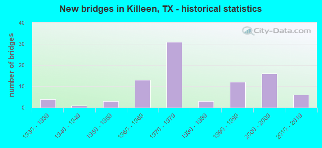
- New bridges - historical statistics
- 41930-1939
- 11940-1949
- 31950-1959
- 131960-1969
- 311970-1979
- 31980-1989
- 121990-1999
- 162000-2009
- 62010-2019
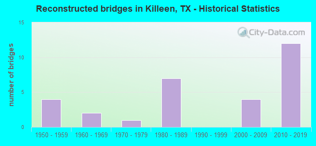
- Reconstructed bridges - Historical Statistics
- 41950-1959
- 21960-1969
- 11970-1979
- 71980-1989
- 01990-1999
- 42000-2009
- 122010-2019
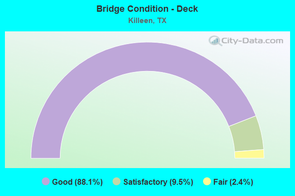
- Bridge Condition - Deck
- 88.1%Good
- 9.5%Satisfactory
- 2.4%Fair
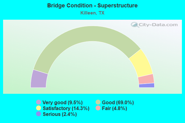
- Bridge Condition - Superstructure
- 9.5%Very good
- 69.0%Good
- 14.3%Satisfactory
- 4.8%Fair
- 2.4%Serious
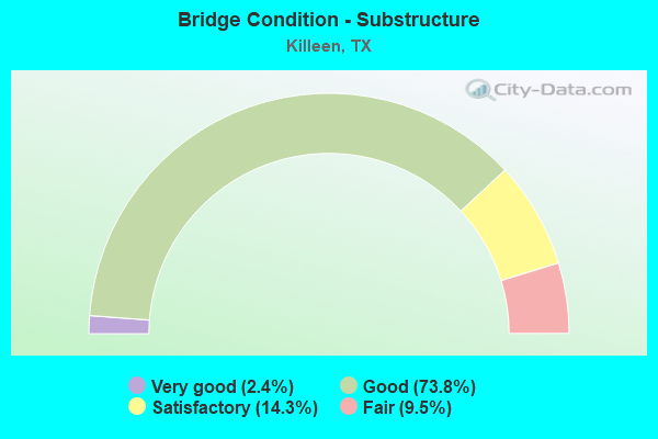
- Bridge Condition - Substructure
- 2.4%Very good
- 73.8%Good
- 14.3%Satisfactory
- 9.5%Fair
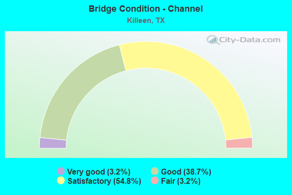
- Bridge Condition - Channel
- 3.2%Very good
- 38.7%Good
- 54.8%Satisfactory
- 3.2%Fair
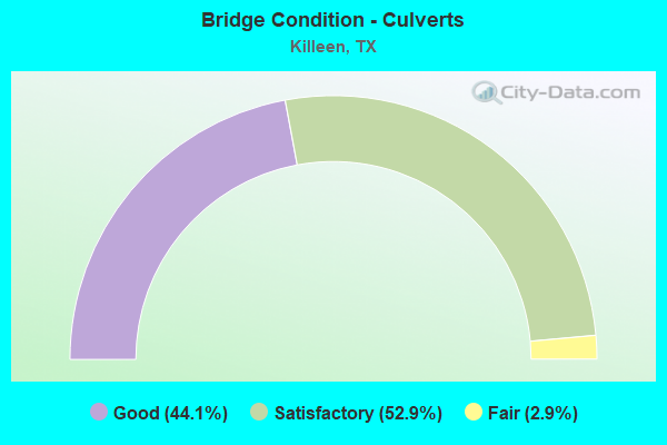
- Bridge Condition - Culverts
- 44.1%Good
- 52.9%Satisfactory
- 2.9%Fair
Find on map >> Show street view
Structure Number: 901400836021, Location: 1.44 MI SW OF FM 3470 (Lat: 31.057111, Lng: -97.765408), Route carried "under" structure: State highway 201, Year Built: 2013, Structure Length: 0. m, Average Daily Traffic: 7,370 (year 2015), Truck Traffic: 13%, Features Intersected: SH 195 NB, Facility Carried by Structure: SH 195 NB
Minimum Vertical Clearance: 5.11m (16.77ft), Kilometerpoint: 0.000, Lanes on structure: 2, Lanes under structure: 8, Material/Design: Prestressed concrete, Design/Construction: Stringer/Multi-beam, Length of Maximum Span: 39.6m (129.9ft)
Find on map >> Show street view
Structure Number: 90140083602101, Location: 1.44 MI SW OF FM 3470 (Lat: 31.057022, Lng: -97.765783), Route carried "under" structure: State highway 201, Year Built: 2013, Structure Length: 0. m, Average Daily Traffic: 7,370 (year 2015), Truck Traffic: 13%, Features Intersected: SH 195 SB, Facility Carried by Structure: SH 195 SB
Minimum Vertical Clearance: 5.23m (17.16ft), Kilometerpoint: 0.000, Lanes on structure: 2, Lanes under structure: 8, Material/Design: Prestressed concrete, Design/Construction: Stringer/Multi-beam, Length of Maximum Span: 39.6m (129.9ft)