Bridge Statistics for Lawrence, Kansas (KS)
Condition, Traffic, Stress, Structural Evaluation, Project Costs
- National Bridge Inventory (NBI) Statistics
- 189Number of bridges
- 3,271ft / 997mTotal length
- $2,702,000Total costs
- 1,366,918Total average daily traffic
- 134,416Total average daily truck traffic
- National Bridge Inventory (NBI) Registered Bridges for Lawrence
- No street view available for this location
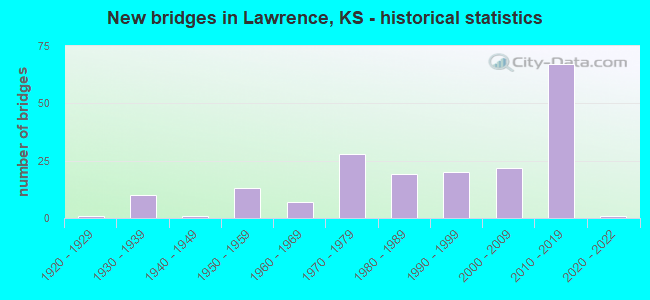
- New bridges - historical statistics
- 11920-1929
- 101930-1939
- 11940-1949
- 131950-1959
- 71960-1969
- 281970-1979
- 191980-1989
- 201990-1999
- 222000-2009
- 672010-2019
- 12020-2022
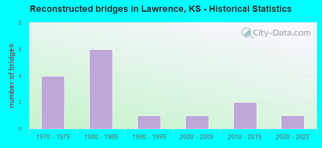
- Reconstructed bridges - Historical Statistics
- 41970-1979
- 61980-1989
- 11990-1999
- 12000-2009
- 22010-2019
- 12020-2022
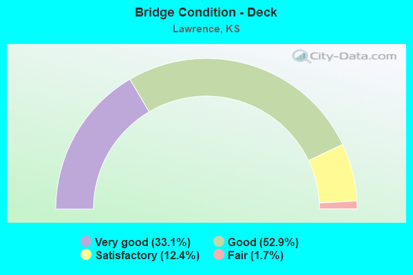
- Bridge Condition - Deck
- 33.1%Very good
- 52.9%Good
- 12.4%Satisfactory
- 1.7%Fair
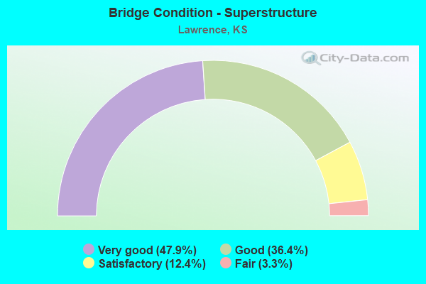
- Bridge Condition - Superstructure
- 47.9%Very good
- 36.4%Good
- 12.4%Satisfactory
- 3.3%Fair
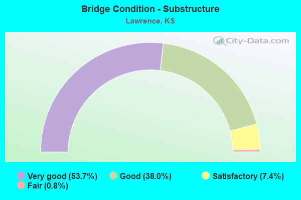
- Bridge Condition - Substructure
- 53.7%Very good
- 38.0%Good
- 7.4%Satisfactory
- 0.8%Fair
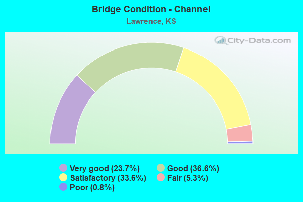
- Bridge Condition - Channel
- 23.7%Very good
- 36.6%Good
- 33.6%Satisfactory
- 5.3%Fair
- 0.8%Poor
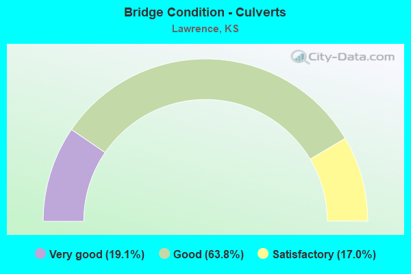
- Bridge Condition - Culverts
- 19.1%Very good
- 63.8%Good
- 17.0%Satisfactory
Find on map >> Show street view
Structure Number: 999905900230621, Location: 6.46 MI. N US56 (Lat: 38.874789, Lng: -95.260019), Route carried "on" structure: ServiceCounty highway 2303, Year Built: 1973, Status: Open, Structure Length: 1.35m (4.43ft), Average Daily Traffic: 4,535 (year 2015), Truck Traffic: 5%, Average Future Daily Traffic: 6,739 (year 2040), Design Load: HS 20, Features Intersected: WAKARUSA RIVER DRG, Facility Carried by Structure: Local 9.33N-13.02E
Minimum Vertical Clearance: 30.47m (99.97ft), Kilometerpoint: 0.000, Lanes on structure: 2, Owner: County Highway Agency, Approaching Roadway Width: 13.4m (44.0ft), Skew: 4 degrees, Material/Design: Concrete, Design/Construction: Culvert, Number Of Spans In Main Unit: 3, Length of Maximum Span: 4.3m (14.1ft)
Condition: Channel: Satisfactory, Culverts: Satisfactory, Operating Rating: 43.6 metric tons, Method Used To Determine Operating Rating: Load Factor (LF), Inventory Rating: 26.1 metric tons, Method Used To Determine Inventory Rating: Load Factor (LF), Structural Evaluation: Equal to present minimum criteria, Waterway Adequacy: Better than present minimum criteria, Approach Roadway Alignment: Somewhat better than minimum adequacy, Length Of Structure Improvement: 1.35m (4.43ft), Designated Inspection Frequency: Every 24 months, Inspection Date: March 2020, Bridge Improvement Cost: $370,000, Roadway Improvement Cost: $40,000, Total Project Cost: $550,000 ( Estimate for 2018)
Find on map >> Show street view
Structure Number: 999905900230631, Location: 8.65 MI N US56 (Lat: 38.907778, Lng: -95.260556), Route carried "on" structure: US 59, Year Built: 1975, Status: Open, Structure Length: 5.56m (18.24ft), Average Daily Traffic: 6,162 (year 2020), Truck Traffic: 5%, Average Future Daily Traffic: 9,156 (year 2041), Design Load: HS 20, Features Intersected: S OVERFLOW WAKA RIV
Minimum Vertical Clearance: 30.47m (99.97ft), Kilometerpoint: 19.003, Lanes on structure: 3, Base Highway Network: Yes, Owner: State Highway Agency, Approaching Roadway Width: 12.2m (40.0ft), Material/Design: Concrete continuous, Design/Construction: Slab, Number Of Spans In Main Unit: 5, Length of Maximum Span: 12.2m (40.0ft), Curb-To-Curb Width: 14.6m (47.9ft), Out-to-Out Width: 15.2m (49.9ft)
Condition: Deck: Satisfactory, Superstructure: Good, Substructure: Very good, Channel: Good, Operating Rating: 55.3 metric tons, Method Used To Determine Operating Rating: Load Factor (LF), Inventory Rating: 33.6 metric tons, Method Used To Determine Inventory Rating: Load Factor (LF), Structural Evaluation: Better than present minimum criteria, Deck Geometry: Meets minimum limits, Waterway Adequacy: Equal to present minimum criteria, Approach Roadway Alignment: Equal to present desirable criteria, Length Of Structure Improvement: 18.25m (59.88ft), Designated Inspection Frequency: Every 24 months, Inspection Date: April 2020, Deck Structure Type: Concrete Cast-file-Place, Wearing Surface/Protective System: Wearing Surface: Low Slump Concrete
Find on map >> Show street view
Structure Number: 999905900230641, Location: 8.64 MI N US 56 (Lat: 38.907778, Lng: -95.260278), Route carried "on" structure: US 59, Year Built: 1975, Status: Open, Structure Length: 5.56m (18.24ft), Average Daily Traffic: 6,162 (year 2020), Truck Traffic: 5%, Average Future Daily Traffic: 9,156 (year 2041), Design Load: HS 20, Features Intersected: S OVERFLOW WAKA RIV
Minimum Vertical Clearance: 30.47m (99.97ft), Kilometerpoint: 19.005, Lanes on structure: 3, Base Highway Network: Yes, Owner: State Highway Agency, Approaching Roadway Width: 12.2m (40.0ft), Material/Design: Concrete continuous, Design/Construction: Slab, Number Of Spans In Main Unit: 5, Length of Maximum Span: 12.2m (40.0ft), Curb-To-Curb Width: 15.8m (51.8ft), Out-to-Out Width: 16.5m (54.1ft)
Condition: Deck: Satisfactory, Superstructure: Good, Substructure: Good, Channel: Satisfactory, Operating Rating: 61.7 metric tons, Method Used To Determine Operating Rating: Load Factor (LF), Inventory Rating: 37.2 metric tons, Method Used To Determine Inventory Rating: Load Factor (LF), Structural Evaluation: Better than present minimum criteria, Deck Geometry: Somewhat better than minimum adequacy, Waterway Adequacy: Equal to present minimum criteria, Approach Roadway Alignment: Equal to present desirable criteria, Length Of Structure Improvement: 18.25m (59.88ft), Designated Inspection Frequency: Every 24 months, Inspection Date: April 2020, Deck Structure Type: Concrete Cast-file-Place, Wearing Surface/Protective System: Wearing Surface: Low Slump Concrete
Find on map >> Show street view
Structure Number: 999905900230651, Location: 8.97 MI N US56 (Lat: 38.910833, Lng: -95.260556), Route carried "on" structure: US 59, Year Built: 1975, Status: Open, Structure Length: 6.81m (22.34ft), Average Daily Traffic: 6,162 (year 2020), Truck Traffic: 5%, Average Future Daily Traffic: 9,156 (year 2041), Design Load: HS 20, Features Intersected: WAKARUSA RIVER
Minimum Vertical Clearance: 30.47m (99.97ft), Kilometerpoint: 19.357, Lanes on structure: 2, Base Highway Network: Yes, Owner: State Highway Agency, Approaching Roadway Width: 12.2m (40.0ft), Material/Design: Concrete continuous, Design/Construction: Tee Beam, Number Of Spans In Main Unit: 3, Length of Maximum Span: 27.7m (90.9ft), Curb-To-Curb Width: 12.2m (40.0ft), Out-to-Out Width: 12.8m (42.0ft)
Condition: Deck: Satisfactory, Superstructure: Satisfactory, Substructure: Satisfactory, Channel: Good, Operating Rating: 68.3 metric tons, Method Used To Determine Operating Rating: Load Factor (LF), Inventory Rating: 40.9 metric tons, Method Used To Determine Inventory Rating: Load Factor (LF), Structural Evaluation: Equal to present minimum criteria, Deck Geometry: Better than present minimum criteria, Waterway Adequacy: Somewhat better than minimum adequacy, Approach Roadway Alignment: Equal to present desirable criteria, Length Of Structure Improvement: 22.35m (73.33ft), Designated Inspection Frequency: Every 24 months, Inspection Date: April 2020, Deck Structure Type: Concrete Cast-file-Place, Wearing Surface/Protective System: Wearing Surface: Low Slump Concrete
Find on map >> Show street view
Structure Number: 999905900230661, Location: 8.97 MI N US 56 (Lat: 38.910833, Lng: -95.260278), Route carried "on" structure: US 59, Year Built: 1975, Status: Open, Structure Length: 6.81m (22.34ft), Average Daily Traffic: 6,162 (year 2020), Truck Traffic: 5%, Average Future Daily Traffic: 9,156 (year 2041), Design Load: HS 20, Features Intersected: WAKARUSA RIVER
Minimum Vertical Clearance: 30.47m (99.97ft), Kilometerpoint: 19.356, Lanes on structure: 2, Base Highway Network: Yes, Owner: State Highway Agency, Approaching Roadway Width: 12.2m (40.0ft), Material/Design: Concrete continuous, Design/Construction: Tee Beam, Number Of Spans In Main Unit: 3, Length of Maximum Span: 27.7m (90.9ft), Curb-To-Curb Width: 12.2m (40.0ft), Out-to-Out Width: 12.8m (42.0ft)
Condition: Deck: Satisfactory, Superstructure: Satisfactory, Substructure: Good, Channel: Good, Operating Rating: 70.4 metric tons, Method Used To Determine Operating Rating: Load Factor (LF), Inventory Rating: 42.2 metric tons, Method Used To Determine Inventory Rating: Load Factor (LF), Structural Evaluation: Equal to present minimum criteria, Deck Geometry: Better than present minimum criteria, Waterway Adequacy: Somewhat better than minimum adequacy, Approach Roadway Alignment: Equal to present desirable criteria, Length Of Structure Improvement: 22.35m (73.33ft), Designated Inspection Frequency: Every 24 months, Inspection Date: April 2020, Deck Structure Type: Concrete Cast-file-Place, Wearing Surface/Protective System: Wearing Surface: Low Slump Concrete
Find on map >> Show street view
Structure Number: 999905900230671, Location: 9.33 MI N US56 (Lat: 38.916389, Lng: -95.260556), Route carried "on" structure: US 59, Year Built: 1973, Status: Open, Structure Length: 4.37m (14.34ft), Average Daily Traffic: 6,162 (year 2020), Truck Traffic: 5%, Average Future Daily Traffic: 9,156 (year 2041), Design Load: HS 20, Features Intersected: N OVERFLOW WAKA RIV
Minimum Vertical Clearance: 30.47m (99.97ft), Kilometerpoint: 19.970, Lanes on structure: 2, Base Highway Network: Yes, Owner: State Highway Agency, Approaching Roadway Width: 12.2m (40.0ft), Skew: 4 degrees, Material/Design: Concrete continuous, Design/Construction: Slab, Number Of Spans In Main Unit: 4, Length of Maximum Span: 12.2m (40.0ft), Curb-To-Curb Width: 12.2m (40.0ft), Out-to-Out Width: 12.8m (42.0ft)
Condition: Deck: Good, Superstructure: Good, Substructure: Very good, Channel: Good, Operating Rating: 61.7 metric tons, Method Used To Determine Operating Rating: Load Factor (LF), Inventory Rating: 37.2 metric tons, Method Used To Determine Inventory Rating: Load Factor (LF), Structural Evaluation: Better than present minimum criteria, Deck Geometry: Better than present minimum criteria, Waterway Adequacy: Equal to present desirable criteria, Approach Roadway Alignment: Equal to present desirable criteria, Length Of Structure Improvement: 14.33m (47.01ft), Designated Inspection Frequency: Every 24 months, Inspection Date: April 2020, Deck Structure Type: Concrete Cast-file-Place, Wearing Surface/Protective System: Wearing Surface: Low Slump Concrete
Find on map >> Show street view
Structure Number: 999905900230681, Location: 9.32 MI N US56 (Lat: 38.916111, Lng: -95.260278), Route carried "on" structure: US 59, Year Built: 1973, Status: Open, Structure Length: 4.37m (14.34ft), Average Daily Traffic: 6,162 (year 2020), Truck Traffic: 5%, Average Future Daily Traffic: 9,156 (year 2041), Design Load: HS 20, Features Intersected: N OVERFLOW WAKA RIV
Minimum Vertical Clearance: 30.47m (99.97ft), Kilometerpoint: 19.948, Lanes on structure: 2, Base Highway Network: Yes, Owner: State Highway Agency, Approaching Roadway Width: 12.2m (40.0ft), Skew: 4 degrees, Material/Design: Concrete continuous, Design/Construction: Slab, Number Of Spans In Main Unit: 4, Length of Maximum Span: 12.2m (40.0ft), Curb-To-Curb Width: 12.2m (40.0ft), Out-to-Out Width: 12.8m (42.0ft)
Condition: Deck: Satisfactory, Superstructure: Good, Substructure: Very good, Channel: Good, Operating Rating: 61.7 metric tons, Method Used To Determine Operating Rating: Load Factor (LF), Inventory Rating: 37.2 metric tons, Method Used To Determine Inventory Rating: Load Factor (LF), Structural Evaluation: Better than present minimum criteria, Deck Geometry: Better than present minimum criteria, Waterway Adequacy: Equal to present desirable criteria, Approach Roadway Alignment: Equal to present desirable criteria, Length Of Structure Improvement: 14.33m (47.01ft), Designated Inspection Frequency: Every 24 months, Inspection Date: April 2020, Deck Structure Type: Concrete Cast-file-Place, Wearing Surface/Protective System: Wearing Surface: Low Slump Concrete
Find on map >> Show street view
Structure Number: 999905900231161, Location: 5.3M N OF JCT US-56/US-59 (Lat: 38.858889, Lng: -95.260833), Route carried "on" structure: US 59, Year Built: 2012, Status: Open, Structure Length: 1.41m (4.63ft), Average Daily Traffic: 5,253 (year 2020), Truck Traffic: 6%, Average Future Daily Traffic: 7,806 (year 2041), Design Load: HS 25 or greater, Features Intersected: W TRIB PLEASANT GROVE CR
Minimum Vertical Clearance: 30.47m (99.97ft), Kilometerpoint: 13.490, Lanes on structure: 4, Base Highway Network: Yes, Owner: State Highway Agency, Approaching Roadway Width: 24.4m (80.1ft), Skew: 24 degrees, Material/Design: Concrete, Design/Construction: Culvert, Number Of Spans In Main Unit: 2, Length of Maximum Span: 4.9m (16.1ft), Curb-To-Curb Width: 24.4m (80.1ft), Out-to-Out Width: 118.1m (387.5ft)
Condition: Channel: Good, Culverts: Very good, Inventory Rating: 83.5 metric tons, Method Used To Determine Inventory Rating: Load Factor (LF), Structural Evaluation: Equal to present desirable criteria, Deck Geometry: Superior to present desirable criteria, Waterway Adequacy: Equal to present desirable criteria, Approach Roadway Alignment: Equal to present desirable criteria, Length Of Structure Improvement: 5.38m (17.65ft), Designated Inspection Frequency: Every 24 months, Inspection Date: April 2020, Deck Structure Type: Concrete Cast-file-Place, Wearing Surface/Protective System: Wearing Surface: Low Slump Concrete
Find on map >> Show street view
Structure Number: 999905900231171, Location: 6.2 MI N JCT US-56/US-59 (Lat: 38.869722, Lng: -95.255833), Route carried "on" structure: ServiceCounty highway 1313, Year Built: 2012, Status: Open, Structure Length: 10.45m (34.28ft), Average Daily Traffic: 42 (year 2020), Average Future Daily Traffic: 7,727 (year 2041), Design Load: HL 93, Features Intersected: US-59 HIGHWAY NB-SB, Facility Carried by Structure: 900N ROAD
Minimum Vertical Clearance: 30.47m (99.97ft), Kilometerpoint: 0.105, Lanes on structure: 2, Lanes under structure: 4, Owner: State Highway Agency, Approaching Roadway Width: 11.0m (36.1ft), Material/Design: Steel continuous, Design/Construction: Stringer/Multi-beam, Number Of Spans In Main Unit: 4, Length of Maximum Span: 30.5m (100.1ft), Curb-To-Curb Width: 11.0m (36.1ft), Out-to-Out Width: 11.6m (38.1ft)
Condition: Deck: Very good, Superstructure: Very good, Substructure: Very good, Operating Rating: 65.8 metric tons, Method Used To Determine Operating Rating: Load and Resistance Factor Rating (LRFR) rating reported by rating factor(RF) method using HL-93 loadings, Inventory Rating: 50.5 metric tons, Method Used To Determine Inventory Rating: Load and Resistance Factor Rating (LRFR) rating reported by rating factor(RF) method using HL-93 loadings, Structural Evaluation: Equal to present desirable criteria, Deck Geometry: Superior to present desirable criteria, Underclear: Better than present minimum criteria, Approach Roadway Alignment: Somewhat better than minimum adequacy, Length Of Structure Improvement: 34.30m (112.53ft), Designated Inspection Frequency: Every 24 months, Inspection Date: April 2020, Wearing Surface/Protective System: Wearing Surface: Monolithic Concrete, Deck Protection: Epoxy Coated Reinforcing
Find on map >> Show street view
Structure Number: 999905900231181, Location: ADJ 6.34M N JCT US56/US59 (Lat: 38.872569, Lng: -95.254761), Route carried "on" structure: County highway 5503, Year Built: 2011, Status: Open, Structure Length: 0.89m (2.92ft), Average Daily Traffic: 10 (year 2018), Truck Traffic: 5%, Average Future Daily Traffic: 50 (year 2040), Design Load: HL 93, Features Intersected: W TRIB PLEASANT GROVE CK, Facility Carried by Structure: Local 9.81N-13.30E
Minimum Vertical Clearance: 30.47m (99.97ft), Kilometerpoint: 0.000, Lanes on structure: 2, Owner: County Highway Agency, Approaching Roadway Width: 7.9m (25.9ft), Skew: 4 degrees, Material/Design: Concrete, Design/Construction: Culvert, Number Of Spans In Main Unit: 2, Length of Maximum Span: 4.3m (14.1ft)
Condition: Channel: Good, Culverts: Very good, Inventory Rating: 33.6 metric tons, Method Used To Determine Inventory Rating: Load Factor (LF), Structural Evaluation: Equal to present desirable criteria, Waterway Adequacy: Equal to present desirable criteria, Approach Roadway Alignment: Somewhat better than minimum adequacy, Designated Inspection Frequency: Every 24 months, Inspection Date: March 2020
Find on map >> Show street view
Structure Number: 999905900231191, Location: 6.4M N OF JCT US-56/US-59 (Lat: 38.873056, Lng: -95.255556), Route carried "on" structure: US 59, Year Built: 2012, Status: Open, Structure Length: 0.95m (3.12ft), Average Daily Traffic: 5,253 (year 2020), Truck Traffic: 6%, Average Future Daily Traffic: 7,806 (year 2041), Design Load: HS 25 or greater, Features Intersected: W TRIB PLEASANT GROVE CR
Minimum Vertical Clearance: 30.47m (99.97ft), Kilometerpoint: 15.131, Lanes on structure: 4, Base Highway Network: Yes, Owner: State Highway Agency, Approaching Roadway Width: 24.4m (80.1ft), Skew: 24 degrees, Material/Design: Concrete, Design/Construction: Culvert, Number Of Spans In Main Unit: 2, Length of Maximum Span: 3.1m (10.2ft), Curb-To-Curb Width: 24.4m (80.1ft), Out-to-Out Width: 64.7m (212.3ft)
Condition: Channel: Good, Culverts: Good, Inventory Rating: 89.8 metric tons, Method Used To Determine Inventory Rating: Load Factor (LF), Structural Evaluation: Better than present minimum criteria, Deck Geometry: Superior to present desirable criteria, Waterway Adequacy: Better than present minimum criteria, Approach Roadway Alignment: Equal to present desirable criteria, Length Of Structure Improvement: 3.11m (10.20ft), Designated Inspection Frequency: Every 24 months, Inspection Date: April 2020, Deck Structure Type: Concrete Cast-file-Place, Wearing Surface/Protective System: Wearing Surface: Low Slump Concrete
Find on map >> Show street view
Structure Number: 999905900231201, Location: 6.65 MI N JCT US-56/US-59 (Lat: 38.876667, Lng: -95.256389), Route carried "on" structure: US 59, Year Built: 2012, Status: Open, Structure Length: 4.95m (16.24ft), Average Daily Traffic: 5,253 (year 2020), Truck Traffic: 6%, Average Future Daily Traffic: 7,806 (year 2041), Design Load: HL 93, Features Intersected: W TRIB PLEASANT GROVE CR
Minimum Vertical Clearance: 30.47m (99.97ft), Kilometerpoint: 15.541, Lanes on structure: 2, Base Highway Network: Yes, Owner: State Highway Agency, Approaching Roadway Width: 12.2m (40.0ft), Material/Design: Concrete continuous, Design/Construction: Slab, Number Of Spans In Main Unit: 3, Length of Maximum Span: 19.5m (64.0ft), Curb-To-Curb Width: 12.2m (40.0ft), Out-to-Out Width: 12.8m (42.0ft)
Condition: Deck: Good, Superstructure: Very good, Substructure: Very good, Channel: Good, Operating Rating: 60.9 metric tons, Method Used To Determine Operating Rating: Load and Resistance Factor Rating (LRFR) rating reported by rating factor(RF) method using HL-93 loadings, Inventory Rating: 47.0 metric tons, Method Used To Determine Inventory Rating: Load and Resistance Factor Rating (LRFR) rating reported by rating factor(RF) method using HL-93 loadings, Structural Evaluation: Equal to present desirable criteria, Deck Geometry: Better than present minimum criteria, Waterway Adequacy: Equal to present desirable criteria, Approach Roadway Alignment: Equal to present desirable criteria, Length Of Structure Improvement: 16.25m (53.31ft), Designated Inspection Frequency: Every 24 months, Inspection Date: April 2020, Wearing Surface/Protective System: Wearing Surface: Monolithic Concrete, Deck Protection: Epoxy Coated Reinforcing
Find on map >> Show street view
Structure Number: 999905900231211, Location: 6.66 MI N JCT US-56/US-59 (Lat: 38.876944, Lng: -95.255833), Route carried "on" structure: US 59, Year Built: 2012, Status: Open, Structure Length: 4.95m (16.24ft), Average Daily Traffic: 5,253 (year 2020), Truck Traffic: 6%, Average Future Daily Traffic: 7,806 (year 2041), Design Load: HL 93, Features Intersected: W TRIB PLEASANT GROVE CR
Minimum Vertical Clearance: 30.47m (99.97ft), Kilometerpoint: 15.546, Lanes on structure: 2, Base Highway Network: Yes, Owner: State Highway Agency, Approaching Roadway Width: 12.2m (40.0ft), Material/Design: Concrete continuous, Design/Construction: Slab, Number Of Spans In Main Unit: 3, Length of Maximum Span: 19.5m (64.0ft), Curb-To-Curb Width: 12.2m (40.0ft), Out-to-Out Width: 12.8m (42.0ft)
Condition: Deck: Good, Superstructure: Very good, Substructure: Very good, Channel: Very good, Operating Rating: 60.9 metric tons, Method Used To Determine Operating Rating: Load and Resistance Factor Rating (LRFR) rating reported by rating factor(RF) method using HL-93 loadings, Inventory Rating: 47.0 metric tons, Method Used To Determine Inventory Rating: Load and Resistance Factor Rating (LRFR) rating reported by rating factor(RF) method using HL-93 loadings, Structural Evaluation: Equal to present desirable criteria, Deck Geometry: Better than present minimum criteria, Waterway Adequacy: Equal to present desirable criteria, Approach Roadway Alignment: Equal to present desirable criteria, Length Of Structure Improvement: 16.25m (53.31ft), Designated Inspection Frequency: Every 24 months, Inspection Date: April 2020, Wearing Surface/Protective System: Wearing Surface: Monolithic Concrete, Deck Protection: Epoxy Coated Reinforcing
Find on map >> Show street view
Structure Number: 999905900231221, Location: 7.2 MI N JCT US-56/US-59 (Lat: 38.884444, Lng: -95.258056), Route carried "on" structure: US 59, Year Built: 2012, Status: Open, Structure Length: 8.63m (28.31ft), Average Daily Traffic: 5,253 (year 2020), Truck Traffic: 6%, Average Future Daily Traffic: 7,806 (year 2041), Design Load: HL 93, Features Intersected: 1000 N Road
Minimum Vertical Clearance: 30.47m (99.97ft), Kilometerpoint: 16.398, Lanes on structure: 2, Lanes under structure: 2, Base Highway Network: Yes, Owner: State Highway Agency, Approaching Roadway Width: 12.2m (40.0ft), Material/Design: Steel continuous, Design/Construction: Stringer/Multi-beam, Number Of Spans In Main Unit: 3, Length of Maximum Span: 36.6m (120.1ft), Curb-To-Curb Width: 12.2m (40.0ft), Out-to-Out Width: 12.8m (42.0ft)
Condition: Deck: Good, Superstructure: Very good, Substructure: Very good, Operating Rating: 58.6 metric tons, Method Used To Determine Operating Rating: Load and Resistance Factor Rating (LRFR) rating reported by rating factor(RF) method using HL-93 loadings, Inventory Rating: 45.0 metric tons, Method Used To Determine Inventory Rating: Load and Resistance Factor Rating (LRFR) rating reported by rating factor(RF) method using HL-93 loadings, Structural Evaluation: Equal to present desirable criteria, Deck Geometry: Better than present minimum criteria, Underclear: Superior to present desirable criteria, Approach Roadway Alignment: Equal to present desirable criteria, Length Of Structure Improvement: 28.30m (92.85ft), Designated Inspection Frequency: Every 24 months, Inspection Date: April 2020, Wearing Surface/Protective System: Wearing Surface: Monolithic Concrete, Deck Protection: Epoxy Coated Reinforcing
Find on map >> Show street view
Structure Number: 999905900231231, Location: 7.2 MI N JCT US-56/US-59 (Lat: 38.884167, Lng: -95.258333), Route carried "on" structure: US 59, Year Built: 2012, Status: Open, Structure Length: 8.63m (28.31ft), Average Daily Traffic: 5,253 (year 2020), Truck Traffic: 6%, Average Future Daily Traffic: 7,806 (year 2041), Design Load: HL 93, Features Intersected: 1000N ROAD
Minimum Vertical Clearance: 30.47m (99.97ft), Kilometerpoint: 16.398, Lanes on structure: 2, Lanes under structure: 2, Base Highway Network: Yes, Owner: State Highway Agency, Approaching Roadway Width: 12.2m (40.0ft), Material/Design: Steel continuous, Design/Construction: Stringer/Multi-beam, Number Of Spans In Main Unit: 3, Length of Maximum Span: 36.6m (120.1ft), Curb-To-Curb Width: 12.2m (40.0ft), Out-to-Out Width: 12.8m (42.0ft)
Condition: Deck: Good, Superstructure: Very good, Substructure: Good, Operating Rating: 58.6 metric tons, Method Used To Determine Operating Rating: Load and Resistance Factor Rating (LRFR) rating reported by rating factor(RF) method using HL-93 loadings, Inventory Rating: 45.0 metric tons, Method Used To Determine Inventory Rating: Load and Resistance Factor Rating (LRFR) rating reported by rating factor(RF) method using HL-93 loadings, Structural Evaluation: Better than present minimum criteria, Deck Geometry: Better than present minimum criteria, Underclear: Superior to present desirable criteria, Approach Roadway Alignment: Equal to present desirable criteria, Length Of Structure Improvement: 28.30m (92.85ft), Designated Inspection Frequency: Every 24 months, Inspection Date: April 2020, Wearing Surface/Protective System: Wearing Surface: Monolithic Concrete, Deck Protection: Epoxy Coated Reinforcing
Find on map >> Show street view
Structure Number: 999907000230363, Location: 10.17 MI E SHAWNEE CL (Lat: 38.997778, Lng: -95.316389), Route carried "on" structure: County highway 3271, Year Built: 1956, Status: Open, Structure Length: 4.95m (16.24ft), Average Daily Traffic: 300 (year 2020), Truck Traffic: 7%, Average Future Daily Traffic: 429 (year 2041), Features Intersected: I-70 HWY (KTA), Facility Carried by Structure: LOCAL ROAD
Minimum Vertical Clearance: 30.47m (99.97ft), Kilometerpoint: 2.963, Lanes on structure: 2, Lanes under structure: 4, Owner: State Toll Authority, Approaching Roadway Width: 7.3m (24.0ft), Material/Design: Steel continuous, Design/Construction: Girder and Floorbeam System, Number Of Spans In Main Unit: 4, Length of Maximum Span: 14.0m (45.9ft), Curb-To-Curb Width: 6.1m (20.0ft), Out-to-Out Width: 7.7m (25.3ft)
Condition: Deck: Good, Superstructure: Good, Substructure: Good, Operating Rating: 31.5 metric tons, Method Used To Determine Operating Rating: Load Factor (LF), Inventory Rating: 18.9 metric tons, Method Used To Determine Inventory Rating: Load Factor (LF), Structural Evaluation: Somewhat better than minimum adequacy, Deck Geometry: Meets minimum limits, Underclear: High priority of corrective action, Approach Roadway Alignment: Somewhat better than minimum adequacy, Length Of Structure Improvement: 16.25m (53.31ft), Designated Inspection Frequency: Every 24 months, Critical Feature Inspection Frequency: Every 24 months, Inspection Date: June 2020, Critical Feature Inspection Date: October 2021, Deck Structure Type: Concrete Cast-file-Place, Wearing Surface/Protective System: Wearing Surface: Low Slump Concrete
Find on map >> Show street view
Structure Number: 999907000230373, Location: 11.20 MI E SHAWNEE CO LN (Lat: 38.997778, Lng: -95.296944), Route carried "on" structure: Interstate 70, Year Built: 1956, Year Reconstructed: 1981, Status: Open, Structure Length: 3.64m (11.94ft), Average Daily Traffic: 12,773 (year 2020), Truck Traffic: 22%, Average Future Daily Traffic: 18,980 (year 2041), Design Load: HS 20+Mod, Features Intersected: BALDWIN CREEK
Minimum Vertical Clearance: 30.47m (99.97ft), Kilometerpoint: 18.047, Lanes on structure: 2, Base Highway Network: Yes, Toll: On Interstate toll segment, Owner: State Toll Authority, Approaching Roadway Width: 11.0m (36.1ft), Material/Design: Steel continuous, Design/Construction: Stringer/Multi-beam, Number Of Spans In Main Unit: 3, Length of Maximum Span: 13.7m (44.9ft), Curb-To-Curb Width: 9.8m (32.2ft), Out-to-Out Width: 10.5m (34.4ft)
Condition: Deck: Satisfactory, Superstructure: Good, Substructure: Good, Channel: Good, Operating Rating: 47.5 metric tons, Method Used To Determine Operating Rating: Load Factor (LF), Inventory Rating: 26.1 metric tons, Method Used To Determine Inventory Rating: Load Factor (LF), Structural Evaluation: Equal to present minimum criteria, Deck Geometry: High priority of replacement, Waterway Adequacy: Somewhat better than minimum adequacy, Approach Roadway Alignment: Equal to present minimum criteria, Length Of Structure Improvement: 11.95m (39.21ft), Designated Inspection Frequency: Every 24 months, Inspection Date: June 2020, Deck Structure Type: Concrete Cast-file-Place, Wearing Surface/Protective System: Wearing Surface: Epoxy Overlay, Deck Protection: Epoxy Coated Reinforcing
Find on map >> Show street view
Structure Number: 999907000230383, Location: 11.10 MI E SHAWNEE CL (Lat: 38.997500, Lng: -95.296944), Route carried "on" structure: Interstate 70, Year Built: 1956, Year Reconstructed: 1981, Status: Open, Structure Length: 3.64m (11.94ft), Average Daily Traffic: 12,773 (year 2020), Truck Traffic: 22%, Average Future Daily Traffic: 18,980 (year 2041), Design Load: HS 20+Mod, Features Intersected: BALDWIN CREEK
Minimum Vertical Clearance: 30.47m (99.97ft), Kilometerpoint: 18.046, Lanes on structure: 2, Base Highway Network: Yes, Toll: On Interstate toll segment, Owner: State Toll Authority, Approaching Roadway Width: 11.0m (36.1ft), Material/Design: Steel continuous, Design/Construction: Stringer/Multi-beam, Number Of Spans In Main Unit: 3, Length of Maximum Span: 13.7m (44.9ft), Curb-To-Curb Width: 9.8m (32.2ft), Out-to-Out Width: 10.5m (34.4ft)
Condition: Deck: Good, Superstructure: Good, Substructure: Good, Channel: Good, Operating Rating: 47.5 metric tons, Method Used To Determine Operating Rating: Load Factor (LF), Inventory Rating: 26.1 metric tons, Method Used To Determine Inventory Rating: Load Factor (LF), Structural Evaluation: Equal to present minimum criteria, Deck Geometry: High priority of replacement, Waterway Adequacy: Somewhat better than minimum adequacy, Approach Roadway Alignment: Equal to present minimum criteria, Length Of Structure Improvement: 11.95m (39.21ft), Designated Inspection Frequency: Every 24 months, Inspection Date: June 2020, Deck Structure Type: Concrete Cast-file-Place, Wearing Surface/Protective System: Wearing Surface: Epoxy Overlay, Deck Protection: Epoxy Coated Reinforcing
Find on map >> Show street view
Structure Number: 999907000230533, Location: 1.51 MI E US-40 & 59 (Lat: 38.993611, Lng: -95.205278), Route carried "on" structure: Interstate 70, Year Built: 1956, Year Reconstructed: 1980, Status: Open, Structure Length: 3.43m (11.25ft), Average Daily Traffic: 13,364 (year 2020), Truck Traffic: 22%, Average Future Daily Traffic: 20,652 (year 2041), Design Load: HS 20+Mod, Features Intersected: LOCAL ROAD
Minimum Vertical Clearance: 30.47m (99.97ft), Kilometerpoint: 26.131, Lanes on structure: 2, Lanes under structure: 2, Base Highway Network: Yes, Toll: On Interstate toll segment, Owner: State Toll Authority, Approaching Roadway Width: 11.0m (36.1ft), Material/Design: Steel continuous, Design/Construction: Stringer/Multi-beam, Number Of Spans In Main Unit: 3, Length of Maximum Span: 12.8m (42.0ft), Curb-To-Curb Width: 9.8m (32.2ft), Out-to-Out Width: 10.5m (34.4ft)
Condition: Deck: Good, Superstructure: Good, Substructure: Good, Operating Rating: 53.0 metric tons, Method Used To Determine Operating Rating: Load Factor (LF), Inventory Rating: 28.9 metric tons, Method Used To Determine Inventory Rating: Load Factor (LF), Structural Evaluation: Better than present minimum criteria, Deck Geometry: High priority of replacement, Underclear: Somewhat better than minimum adequacy, Approach Roadway Alignment: Equal to present minimum criteria, Length Of Structure Improvement: 11.25m (36.91ft), Designated Inspection Frequency: Every 24 months, Inspection Date: June 2020, Wearing Surface/Protective System: Wearing Surface: Epoxy Overlay, Deck Protection: Epoxy Coated Reinforcing
Find on map >> Show street view
Structure Number: 999907000230543, Location: 1.50 MI E US-40 & 59 (Lat: 38.993611, Lng: -95.205278), Route carried "on" structure: Interstate 70, Year Built: 1956, Year Reconstructed: 1980, Status: Open, Structure Length: 3.43m (11.25ft), Average Daily Traffic: 13,364 (year 2020), Truck Traffic: 22%, Average Future Daily Traffic: 20,652 (year 2041), Design Load: HS 20+Mod, Features Intersected: LOCAL ROAD
Minimum Vertical Clearance: 30.47m (99.97ft), Kilometerpoint: 26.192, Lanes on structure: 2, Lanes under structure: 2, Base Highway Network: Yes, Toll: On Interstate toll segment, Owner: State Toll Authority, Approaching Roadway Width: 11.0m (36.1ft), Material/Design: Steel continuous, Design/Construction: Stringer/Multi-beam, Number Of Spans In Main Unit: 3, Length of Maximum Span: 12.8m (42.0ft), Curb-To-Curb Width: 9.8m (32.2ft), Out-to-Out Width: 10.5m (34.4ft)
Condition: Deck: Good, Superstructure: Good, Substructure: Good, Operating Rating: 53.0 metric tons, Method Used To Determine Operating Rating: Load Factor (LF), Inventory Rating: 28.9 metric tons, Method Used To Determine Inventory Rating: Load Factor (LF), Structural Evaluation: Better than present minimum criteria, Deck Geometry: High priority of replacement, Underclear: Somewhat better than minimum adequacy, Approach Roadway Alignment: Equal to present minimum criteria, Length Of Structure Improvement: 11.25m (36.91ft), Designated Inspection Frequency: Every 24 months, Inspection Date: June 2020, Deck Structure Type: Concrete Cast-file-Place, Wearing Surface/Protective System: Wearing Surface: Epoxy Overlay, Deck Protection: Epoxy Coated Reinforcing
Find on map >> Show street view
Structure Number: 999907000230553, Location: 2.13 MI E US-40 & 59 (Lat: 38.995000, Lng: -95.193889), Route carried "on" structure: Interstate 70, Year Built: 1956, Status: Open, Structure Length: 8.02m (26.31ft), Average Daily Traffic: 13,364 (year 2020), Truck Traffic: 22%, Average Future Daily Traffic: 20,652 (year 2041), Design Load: HS 20+Mod, Features Intersected: NATURAL LAKE
Minimum Vertical Clearance: 30.47m (99.97ft), Kilometerpoint: 27.185, Lanes on structure: 2, Base Highway Network: Yes, Toll: On Interstate toll segment, Owner: State Toll Authority, Approaching Roadway Width: 11.0m (36.1ft), Material/Design: Steel continuous, Design/Construction: Stringer/Multi-beam, Number Of Spans In Main Unit: 7, Length of Maximum Span: 12.2m (40.0ft), Curb-To-Curb Width: 9.8m (32.2ft), Out-to-Out Width: 10.5m (34.4ft)
Condition: Deck: Good, Superstructure: Good, Substructure: Good, Channel: Very good, Operating Rating: 58.1 metric tons, Method Used To Determine Operating Rating: Load Factor (LF), Inventory Rating: 34.8 metric tons, Method Used To Determine Inventory Rating: Load Factor (LF), Structural Evaluation: Better than present minimum criteria, Deck Geometry: Meets minimum limits, Waterway Adequacy: Equal to present desirable criteria, Approach Roadway Alignment: Equal to present minimum criteria, Length Of Structure Improvement: 22.25m (73.00ft), Designated Inspection Frequency: Every 24 months, Inspection Date: June 2020, Deck Structure Type: Concrete Cast-file-Place, Wearing Surface/Protective System: Wearing Surface: Epoxy Overlay
Find on map >> Show street view
Structure Number: 999907000230563, Location: 2.12 MI E US-40 & 59 (Lat: 38.995278, Lng: -95.193889), Route carried "on" structure: Interstate 70, Year Built: 1956, Status: Open, Structure Length: 8.02m (26.31ft), Average Daily Traffic: 13,364 (year 2020), Truck Traffic: 22%, Average Future Daily Traffic: 20,652 (year 2041), Design Load: HS 20+Mod, Features Intersected: NATURAL LAKE
Minimum Vertical Clearance: 30.47m (99.97ft), Kilometerpoint: 27.119, Lanes on structure: 2, Base Highway Network: Yes, Toll: On Interstate toll segment, Owner: State Toll Authority, Approaching Roadway Width: 11.0m (36.1ft), Material/Design: Steel continuous, Design/Construction: Stringer/Multi-beam, Number Of Spans In Main Unit: 7, Length of Maximum Span: 12.2m (40.0ft), Curb-To-Curb Width: 9.8m (32.2ft), Out-to-Out Width: 10.5m (34.4ft)
Condition: Deck: Good, Superstructure: Good, Substructure: Good, Channel: Very good, Operating Rating: 58.1 metric tons, Method Used To Determine Operating Rating: Load Factor (LF), Inventory Rating: 34.8 metric tons, Method Used To Determine Inventory Rating: Load Factor (LF), Structural Evaluation: Better than present minimum criteria, Deck Geometry: Meets minimum limits, Waterway Adequacy: Equal to present desirable criteria, Approach Roadway Alignment: Equal to present minimum criteria, Length Of Structure Improvement: 22.25m (73.00ft), Designated Inspection Frequency: Every 24 months, Inspection Date: June 2020, Deck Structure Type: Concrete Cast-file-Place, Wearing Surface/Protective System: Wearing Surface: Epoxy Overlay
Find on map >> Show street view
Structure Number: 999907000230573, Location: 2.47 MI E US-40 & 59 (Lat: 38.996111, Lng: -95.188333), Route carried "on" structure: Interstate 70, Year Built: 1956, Year Reconstructed: 1985, Status: Open, Structure Length: 6.78m (22.24ft), Average Daily Traffic: 13,364 (year 2020), Truck Traffic: 22%, Average Future Daily Traffic: 20,652 (year 2041), Design Load: HS 20+Mod, Features Intersected: LOCAL ROAD, ABANDONED RR
Minimum Vertical Clearance: 30.47m (99.97ft), Kilometerpoint: 27.679, Lanes on structure: 2, Lanes under structure: 2, Base Highway Network: Yes, Toll: On Interstate toll segment, Owner: State Toll Authority, Approaching Roadway Width: 11.0m (36.1ft), Skew: 2 degrees, Material/Design: Steel continuous, Design/Construction: Stringer/Multi-beam, Number Of Spans In Main Unit: 4, Length of Maximum Span: 18.0m (59.1ft), Curb-To-Curb Width: 9.8m (32.2ft), Out-to-Out Width: 10.5m (34.4ft)
Condition: Deck: Good, Superstructure: Good, Substructure: Good, Operating Rating: 52.7 metric tons, Method Used To Determine Operating Rating: Load Factor (LF), Inventory Rating: 27.6 metric tons, Method Used To Determine Inventory Rating: Load Factor (LF), Structural Evaluation: Equal to present minimum criteria, Deck Geometry: Meets minimum limits, Underclear: Equal to present minimum criteria, Approach Roadway Alignment: Equal to present minimum criteria, Length Of Structure Improvement: 22.25m (73.00ft), Designated Inspection Frequency: Every 24 months, Inspection Date: June 2020, Deck Structure Type: Concrete Cast-file-Place, Wearing Surface/Protective System: Wearing Surface: Epoxy Overlay
Find on map >> Show street view
Structure Number: 999907000230583, Location: 2.46 MI E US-40 & 59 (Lat: 38.996389, Lng: -95.188333), Route carried "on" structure: Interstate 70, Year Built: 1956, Year Reconstructed: 1985, Status: Open, Structure Length: 6.78m (22.24ft), Average Daily Traffic: 13,364 (year 2020), Truck Traffic: 22%, Average Future Daily Traffic: 20,652 (year 2041), Design Load: HS 20+Mod, Features Intersected: LOCAL ROAD, ABANDONED RR
Minimum Vertical Clearance: 30.47m (99.97ft), Kilometerpoint: 27.679, Lanes on structure: 2, Lanes under structure: 2, Base Highway Network: Yes, Toll: On Interstate toll segment, Owner: State Toll Authority, Approaching Roadway Width: 11.0m (36.1ft), Skew: 2 degrees, Material/Design: Steel continuous, Design/Construction: Stringer/Multi-beam, Number Of Spans In Main Unit: 4, Length of Maximum Span: 18.0m (59.1ft), Curb-To-Curb Width: 8.5m (27.9ft), Out-to-Out Width: 10.1m (33.1ft)
Condition: Deck: Good, Superstructure: Good, Substructure: Very good, Operating Rating: 55.2 metric tons, Method Used To Determine Operating Rating: Load Factor (LF), Inventory Rating: 27.4 metric tons, Method Used To Determine Inventory Rating: Load Factor (LF), Structural Evaluation: Equal to present minimum criteria, Deck Geometry: High priority of corrective action, Underclear: Equal to present minimum criteria, Approach Roadway Alignment: Equal to present minimum criteria, Length Of Structure Improvement: 22.25m (73.00ft), Designated Inspection Frequency: Every 24 months, Inspection Date: June 2020, Wearing Surface/Protective System: Wearing Surface: Epoxy Overlay
Find on map >> Show street view
Structure Number: 999907000231263, Location: 8.14 MI E SHAWNEE CO LN (Lat: 38.996944, Lng: -95.353889), Route carried "on" structure: County highway 3305, Year Built: 2004, Status: Open, Structure Length: 8.26m (27.10ft), Average Daily Traffic: 258 (year 2020), Truck Traffic: 7%, Average Future Daily Traffic: 315 (year 2041), Design Load: HS 20+Mod, Features Intersected: I-70 HWY (KTA), Facility Carried by Structure: LOCAL ROAD
Minimum Vertical Clearance: 30.47m (99.97ft), Kilometerpoint: 5.224, Lanes on structure: 2, Lanes under structure: 6, Owner: State Toll Authority, Approaching Roadway Width: 9.8m (32.2ft), Material/Design: Steel continuous, Design/Construction: Stringer/Multi-beam, Number Of Spans In Main Unit: 4, Length of Maximum Span: 25.0m (82.0ft), Curb-To-Curb Width: 9.8m (32.2ft), Out-to-Out Width: 10.5m (34.4ft)
Condition: Deck: Very good, Superstructure: Very good, Substructure: Very good, Operating Rating: 87.6 metric tons, Method Used To Determine Operating Rating: Load Factor (LF), Inventory Rating: 52.5 metric tons, Method Used To Determine Inventory Rating: Load Factor (LF), Structural Evaluation: Equal to present desirable criteria, Deck Geometry: Better than present minimum criteria, Underclear: High priority of corrective action, Approach Roadway Alignment: Somewhat better than minimum adequacy, Length Of Structure Improvement: 27.10m (88.91ft), Designated Inspection Frequency: Every 24 months, Inspection Date: June 2020, Wearing Surface/Protective System: Wearing Surface: Monolithic Concrete, Deck Protection: Epoxy Coated Reinforcing
Find on map >> Show street view
Structure Number: 999907000231273, Location: 12.19 MI E SHAWNEE CL (Lat: 38.995278, Lng: -95.278889), Route carried "on" structure: County highway 3203, Year Built: 2006, Status: Open, Structure Length: 8.14m (26.71ft), Average Daily Traffic: 4,330 (year 2020), Truck Traffic: 3%, Average Future Daily Traffic: 5,606 (year 2041), Design Load: HL 93, Features Intersected: I-70 HWY (KTA)
Minimum Vertical Clearance: 30.47m (99.97ft), Kilometerpoint: 7.603, Lanes on structure: 2, Lanes under structure: 4, Owner: State Toll Authority, Approaching Roadway Width: 15.8m (51.8ft), Skew: 2 degrees, Material/Design: Prestressed concrete continuous, Design/Construction: Stringer/Multi-beam, Number Of Spans In Main Unit: 4, Length of Maximum Span: 27.4m (89.9ft), Curb or Sidewalk Widths: Left: 1.8m (5.9ft), Right: 1.8m (5.9ft), Curb-To-Curb Width: 15.8m (51.8ft), Out-to-Out Width: 20.9m (68.6ft)
Condition: Deck: Good, Superstructure: Very good, Substructure: Very good, Operating Rating: 76.2 metric tons, Method Used To Determine Operating Rating: Load Factor (LF), Inventory Rating: 37.5 metric tons, Method Used To Determine Inventory Rating: Load Factor (LF), Structural Evaluation: Equal to present desirable criteria, Deck Geometry: Superior to present desirable criteria, Underclear: Equal to present minimum criteria, Approach Roadway Alignment: Better than present minimum criteria, Length Of Structure Improvement: 26.72m (87.66ft), Designated Inspection Frequency: Every 24 months, Inspection Date: June 2020, Deck Structure Type: Concrete Cast-file-Place, Wearing Surface/Protective System: Wearing Surface: Low Slump Concrete, Deck Protection: Epoxy Coated Reinforcing
Find on map >> Show street view
Structure Number: 999907000231373, Location: 13.26 MI E SHAWNEE CL (Lat: 38.990000, Lng: -95.260278), Route carried "on" structure: City street 3213, Year Built: 2008, Status: Open, Structure Length: 9.83m (32.25ft), Average Daily Traffic: 4,983 (year 2020), Truck Traffic: 7%, Average Future Daily Traffic: 6,452 (year 2041), Design Load: HS 25 or greater, Features Intersected: I-70 HWY (KTA)
Minimum Vertical Clearance: 30.47m (99.97ft), Kilometerpoint: 1.070, Lanes on structure: 2, Lanes under structure: 7, Owner: State Toll Authority, Approaching Roadway Width: 10.7m (35.1ft), Skew: 1 degrees, Material/Design: Steel continuous, Design/Construction: Stringer/Multi-beam, Number Of Spans In Main Unit: 4, Length of Maximum Span: 30.5m (100.1ft), Curb or Sidewalk Widths: Left: 0.0m, Right: 1.8m (5.9ft), Curb-To-Curb Width: 10.7m (35.1ft), Out-to-Out Width: 13.6m (44.6ft)
Condition: Deck: Good, Superstructure: Very good, Substructure: Very good, Operating Rating: 43.2 metric tons, Method Used To Determine Operating Rating: Load Factor (LF), Inventory Rating: 32.4 metric tons, Method Used To Determine Inventory Rating: Load Factor (LF), Structural Evaluation: Equal to present desirable criteria, Deck Geometry: Somewhat better than minimum adequacy, Underclear: High priority of corrective action, Approach Roadway Alignment: Somewhat better than minimum adequacy, Length Of Structure Improvement: 32.25m (105.81ft), Designated Inspection Frequency: Every 24 months, Inspection Date: June 2020, Wearing Surface/Protective System: Wearing Surface: Monolithic Concrete, Deck Protection: Epoxy Coated Reinforcing
Find on map >> Show street view
Structure Number: 999907000231383, Location: 0.98 MI W US-40 & 59 (Lat: 38.990278, Lng: -95.251111), Route carried "on" structure: County highway 3221, Year Built: 2009, Status: Open, Structure Length: 8.86m (29.07ft), Average Daily Traffic: 5,987 (year 2020), Truck Traffic: 5%, Average Future Daily Traffic: 6,357 (year 2041), Design Load: HS 25 or greater, Features Intersected: I-70 HWY (KTA)
Minimum Vertical Clearance: 30.47m (99.97ft), Kilometerpoint: 1.907, Lanes on structure: 2, Lanes under structure: 6, Owner: State Toll Authority, Approaching Roadway Width: 10.7m (35.1ft), Skew: 1 degrees, Material/Design: Steel continuous, Design/Construction: Stringer/Multi-beam, Number Of Spans In Main Unit: 4, Length of Maximum Span: 29.0m (95.1ft), Curb or Sidewalk Widths: Left: 0.0m, Right: 1.8m (5.9ft), Curb-To-Curb Width: 10.7m (35.1ft), Out-to-Out Width: 13.6m (44.6ft)
Condition: Deck: Very good, Superstructure: Very good, Substructure: Very good, Operating Rating: 43.2 metric tons, Method Used To Determine Operating Rating: Load Factor (LF), Inventory Rating: 32.4 metric tons, Method Used To Determine Inventory Rating: Load Factor (LF), Structural Evaluation: Equal to present desirable criteria, Deck Geometry: Meets minimum limits, Underclear: High priority of corrective action, Approach Roadway Alignment: Somewhat better than minimum adequacy, Length Of Structure Improvement: 29.06m (95.34ft), Designated Inspection Frequency: Every 24 months, Inspection Date: June 2020, Wearing Surface/Protective System: Wearing Surface: Monolithic Concrete, Deck Protection: Epoxy Coated Reinforcing
Find on map >> Show street view
Structure Number: 999907000231393, Location: 1.31 MI W US-40 & 59 (Lat: 38.989722, Lng: -95.257222), Route carried "on" structure: City street 3215, Year Built: 2009, Status: Open, Structure Length: 8.31m (27.26ft), Average Daily Traffic: 5,490 (year 2020), Truck Traffic: 3%, Average Future Daily Traffic: 6,312 (year 2041), Design Load: HS 25 or greater, Features Intersected: I-70 KTA, Facility Carried by Structure: W LAWRENCE INTR
Minimum Vertical Clearance: 30.47m (99.97ft), Kilometerpoint: 2.174, Lanes on structure: 2, Lanes under structure: 6, Owner: State Toll Authority, Approaching Roadway Width: 14.8m (48.6ft), Skew: 20 degrees, Material/Design: Steel continuous, Design/Construction: Stringer/Multi-beam, Number Of Spans In Main Unit: 4, Length of Maximum Span: 25.0m (82.0ft), Curb-To-Curb Width: 14.8m (48.6ft), Out-to-Out Width: 15.4m (50.5ft)
Condition: Deck: Good, Superstructure: Very good, Substructure: Very good, Operating Rating: 67.2 metric tons, Method Used To Determine Operating Rating: Load Factor (LF), Inventory Rating: 40.3 metric tons, Method Used To Determine Inventory Rating: Load Factor (LF), Structural Evaluation: Equal to present desirable criteria, Deck Geometry: Superior to present desirable criteria, Underclear: Equal to present minimum criteria, Approach Roadway Alignment: Somewhat better than minimum adequacy, Length Of Structure Improvement: 27.25m (89.40ft), Designated Inspection Frequency: Every 24 months, Inspection Date: June 2020, Wearing Surface/Protective System: Wearing Surface: Epoxy Overlay, Deck Protection: Epoxy Coated Reinforcing
Find on map >> Show street view
Structure Number: 999907000231403, Location: 0.78 MI W US-40 & US-59 (Lat: 38.990833, Lng: -95.247222), Route carried "on" structure: Interstate 70, Year Built: 2010, Status: Open, Structure Length: 8.76m (28.74ft), Average Daily Traffic: 13,326 (year 2020), Truck Traffic: 22%, Average Future Daily Traffic: 20,593 (year 2041), Design Load: HS 25 or greater, Features Intersected: BNSF RAILROAD & DRAINAGE
Minimum Vertical Clearance: 30.47m (99.97ft), Kilometerpoint: 22.508, Lanes on structure: 3, Base Highway Network: Yes, Toll: On Interstate toll segment, Owner: State Toll Authority, Approaching Roadway Width: 16.9m (55.4ft), Material/Design: Steel continuous, Design/Construction: Stringer/Multi-beam, Number Of Spans In Main Unit: 4, Length of Maximum Span: 29.0m (95.1ft), Curb-To-Curb Width: 16.9m (55.4ft), Out-to-Out Width: 17.6m (57.7ft)
Condition: Deck: Very good, Superstructure: Very good, Substructure: Very good, Channel: Very good, Operating Rating: 89.8 metric tons, Method Used To Determine Operating Rating: Load Factor (LF), Inventory Rating: 56.6 metric tons, Method Used To Determine Inventory Rating: Load Factor (LF), Structural Evaluation: Equal to present desirable criteria, Deck Geometry: Equal to present minimum criteria, Underclear: Superior to present desirable criteria, Waterway Adequacy: Equal to present desirable criteria, Approach Roadway Alignment: Equal to present desirable criteria, Length Of Structure Improvement: 28.75m (94.32ft), Designated Inspection Frequency: Every 24 months, Inspection Date: June 2020, Wearing Surface/Protective System: Wearing Surface: Epoxy Overlay, Deck Protection: Epoxy Coated Reinforcing
Find on map >> Show street view
Structure Number: 999907000231413, Location: 0.78 MI W US-40 & US-59 (Lat: 38.990833, Lng: -95.247222), Route carried "on" structure: Interstate 70, Year Built: 2011, Status: Open, Structure Length: 8.76m (28.74ft), Average Daily Traffic: 13,326 (year 2020), Truck Traffic: 22%, Average Future Daily Traffic: 20,593 (year 2041), Design Load: HS 25 or greater, Features Intersected: BNSF RAILWAY & DRAINAGE
Minimum Vertical Clearance: 30.47m (99.97ft), Kilometerpoint: 22.502, Lanes on structure: 3, Base Highway Network: Yes, Toll: On Interstate toll segment, Owner: State Toll Authority, Approaching Roadway Width: 16.9m (55.4ft), Material/Design: Steel continuous, Design/Construction: Stringer/Multi-beam, Number Of Spans In Main Unit: 4, Length of Maximum Span: 29.0m (95.1ft), Curb-To-Curb Width: 16.9m (55.4ft), Out-to-Out Width: 17.6m (57.7ft)
Condition: Deck: Very good, Superstructure: Very good, Substructure: Very good, Channel: Very good, Operating Rating: 89.8 metric tons, Method Used To Determine Operating Rating: Load Factor (LF), Inventory Rating: 56.6 metric tons, Method Used To Determine Inventory Rating: Load Factor (LF), Structural Evaluation: Equal to present desirable criteria, Deck Geometry: Equal to present minimum criteria, Underclear: Superior to present desirable criteria, Waterway Adequacy: Equal to present desirable criteria, Approach Roadway Alignment: Equal to present desirable criteria, Length Of Structure Improvement: 28.75m (94.32ft), Designated Inspection Frequency: Every 24 months, Inspection Date: June 2020, Wearing Surface/Protective System: Wearing Surface: Epoxy Overlay, Deck Protection: Epoxy Coated Reinforcing
Find on map >> Show street view
Structure Number: 999907000231423, Location: JCT I70 (KTA)/US40 & 59 (Lat: 38.992778, Lng: -95.233333), Route carried "on" structure: Interstate 70, Year Built: 2010, Status: Open, Structure Length: 7.15m (23.46ft), Average Daily Traffic: 13,326 (year 2020), Truck Traffic: 22%, Average Future Daily Traffic: 20,593 (year 2041), Design Load: HS 25 or greater, Features Intersected: US-40 & 59 HWY
Minimum Vertical Clearance: 30.47m (99.97ft), Kilometerpoint: 23.756, Lanes on structure: 4, Lanes under structure: 4, Base Highway Network: Yes, Toll: On Interstate toll segment, Owner: State Toll Authority, Approaching Roadway Width: 22.8m (74.8ft), Skew: 1 degrees, Material/Design: Steel continuous, Design/Construction: Stringer/Multi-beam, Number Of Spans In Main Unit: 3, Length of Maximum Span: 31.1m (102.0ft), Curb-To-Curb Width: 22.8m (74.8ft), Out-to-Out Width: 25.5m (83.7ft)
Condition: Deck: Very good, Superstructure: Very good, Substructure: Very good, Operating Rating: 86.0 metric tons, Method Used To Determine Operating Rating: Load Factor (LF), Inventory Rating: 51.5 metric tons, Method Used To Determine Inventory Rating: Load Factor (LF), Structural Evaluation: Equal to present desirable criteria, Deck Geometry: Superior to present desirable criteria, Underclear: High priority of corrective action, Approach Roadway Alignment: Equal to present desirable criteria, Length Of Structure Improvement: 23.45m (76.94ft), Designated Inspection Frequency: Every 24 months, Inspection Date: June 2020, Deck Structure Type: Concrete Cast-file-Place, Wearing Surface/Protective System: Wearing Surface: Low Slump Concrete, Deck Protection: Epoxy Coated Reinforcing
Find on map >> Show street view
Structure Number: 999907000231433, Location: JCT I70 (KTA)/US40 & 59 (Lat: 38.993056, Lng: -95.233333), Route carried "on" structure: Interstate 70, Year Built: 2010, Status: Open, Structure Length: 7.15m (23.46ft), Average Daily Traffic: 13,326 (year 2020), Truck Traffic: 22%, Average Future Daily Traffic: 20,593 (year 2041), Design Load: HS 25 or greater, Features Intersected: US-40 & 59 HWY
Minimum Vertical Clearance: 30.47m (99.97ft), Kilometerpoint: 23.752, Lanes on structure: 4, Lanes under structure: 4, Base Highway Network: Yes, Toll: On Interstate toll segment, Owner: State Toll Authority, Approaching Roadway Width: 20.0m (65.6ft), Skew: 1 degrees, Material/Design: Steel continuous, Design/Construction: Stringer/Multi-beam, Number Of Spans In Main Unit: 3, Length of Maximum Span: 31.1m (102.0ft), Curb-To-Curb Width: 20.0m (65.6ft), Out-to-Out Width: 20.7m (67.9ft)
Condition: Deck: Very good, Superstructure: Very good, Substructure: Very good, Operating Rating: 86.0 metric tons, Method Used To Determine Operating Rating: Load Factor (LF), Inventory Rating: 51.5 metric tons, Method Used To Determine Inventory Rating: Load Factor (LF), Structural Evaluation: Equal to present desirable criteria, Deck Geometry: Equal to present minimum criteria, Underclear: High priority of corrective action, Approach Roadway Alignment: Equal to present desirable criteria, Length Of Structure Improvement: 23.45m (76.94ft), Designated Inspection Frequency: Every 24 months, Inspection Date: June 2020, Deck Structure Type: Concrete Cast-file-Place, Wearing Surface/Protective System: Wearing Surface: Low Slump Concrete, Deck Protection: Epoxy Coated Reinforcing
Find on map >> Show street view
Structure Number: 999907000231443, Location: 0.26 MI E US-40 & 59 (Lat: 38.993333, Lng: -95.228333), Route carried "on" structure: Interstate 70, Year Built: 2010, Status: Open, Structure Length: 12.48m (40.94ft), Average Daily Traffic: 13,326 (year 2020), Truck Traffic: 22%, Average Future Daily Traffic: 20,593 (year 2041), Design Load: HS 25 or greater, Features Intersected: EAST LAWRENCE IN+MAPLE G
Minimum Vertical Clearance: 30.47m (99.97ft), Kilometerpoint: 24.140, Lanes on structure: 3, Lanes under structure: 2, Base Highway Network: Yes, Toll: On Interstate toll segment, Owner: State Toll Authority, Approaching Roadway Width: 16.9m (55.4ft), Material/Design: Steel continuous, Design/Construction: Stringer/Multi-beam, Number Of Spans In Main Unit: 5, Length of Maximum Span: 28.0m (91.9ft), Curb-To-Curb Width: 16.9m (55.4ft), Out-to-Out Width: 17.6m (57.7ft)
Condition: Deck: Good, Superstructure: Very good, Substructure: Very good, Channel: Very good, Operating Rating: 89.8 metric tons, Method Used To Determine Operating Rating: Load Factor (LF), Inventory Rating: 63.2 metric tons, Method Used To Determine Inventory Rating: Load Factor (LF), Structural Evaluation: Equal to present desirable criteria, Deck Geometry: Equal to present minimum criteria, Underclear: Superior to present desirable criteria, Waterway Adequacy: Equal to present desirable criteria, Approach Roadway Alignment: Equal to present desirable criteria, Length Of Structure Improvement: 40.95m (134.35ft), Designated Inspection Frequency: Every 24 months, Inspection Date: June 2020, Deck Structure Type: Concrete Cast-file-Place, Wearing Surface/Protective System: Wearing Surface: Low Slump Concrete, Membrane: Other, Deck Protection: Epoxy Coated Reinforcing
Find on map >> Show street view
Structure Number: 999907000231453, Location: 0.27 MI E US-40 & 59 (Lat: 38.993611, Lng: -95.228611), Route carried "on" structure: Interstate 70, Year Built: 2011, Status: Open, Structure Length: 12.48m (40.94ft), Average Daily Traffic: 13,326 (year 2020), Truck Traffic: 22%, Average Future Daily Traffic: 20,593 (year 2041), Design Load: HS 25 or greater, Features Intersected: EAST LAWRENCE INT+STREAM
Minimum Vertical Clearance: 30.47m (99.97ft), Kilometerpoint: 24.137, Lanes on structure: 3, Lanes under structure: 2, Base Highway Network: Yes, Toll: On Interstate toll segment, Owner: State Toll Authority, Approaching Roadway Width: 16.9m (55.4ft), Material/Design: Steel continuous, Design/Construction: Stringer/Multi-beam, Number Of Spans In Main Unit: 5, Length of Maximum Span: 28.0m (91.9ft), Curb-To-Curb Width: 16.9m (55.4ft), Out-to-Out Width: 17.6m (57.7ft)
Condition: Deck: Very good, Superstructure: Very good, Substructure: Very good, Channel: Very good, Operating Rating: 89.8 metric tons, Method Used To Determine Operating Rating: Load Factor (LF), Inventory Rating: 63.2 metric tons, Method Used To Determine Inventory Rating: Load Factor (LF), Structural Evaluation: Equal to present desirable criteria, Deck Geometry: Equal to present minimum criteria, Underclear: Superior to present desirable criteria, Waterway Adequacy: Equal to present desirable criteria, Approach Roadway Alignment: Equal to present desirable criteria, Length Of Structure Improvement: 40.95m (134.35ft), Designated Inspection Frequency: Every 24 months, Inspection Date: June 2020, Wearing Surface/Protective System: Wearing Surface: Low Slump Concrete, Membrane: Built-up, Deck Protection: Epoxy Coated Reinforcing
Find on map >> Show street view
Structure Number: 999907000231463, Location: E LAWRENCE RAMP I-70 WB (Lat: 38.994444, Lng: -95.228611), Route carried "on" structure: Ramp State highway 10, Year Built: 2009, Status: Open, Structure Length: 3.74m (12.27ft), Average Daily Traffic: 1,727 (year 2020), Truck Traffic: 5%, Average Future Daily Traffic: 26,116 (year 2041), Design Load: HS 25 or greater, Features Intersected: MAPLE GROVE DRG CHANNEL, Facility Carried by Structure: E LAWRENCE I-70 WB
Minimum Vertical Clearance: 30.47m (99.97ft), Kilometerpoint: 0.425, Lanes on structure: 1, Owner: State Toll Authority, Approaching Roadway Width: 8.1m (26.6ft), Skew: 2 degrees, Material/Design: Concrete continuous, Design/Construction: Slab, Number Of Spans In Main Unit: 3, Length of Maximum Span: 14.6m (47.9ft), Curb-To-Curb Width: 8.1m (26.6ft), Out-to-Out Width: 8.7m (28.5ft)
Condition: Deck: Very good, Superstructure: Very good, Substructure: Very good, Channel: Good, Operating Rating: 86.0 metric tons, Method Used To Determine Operating Rating: Load Factor (LF), Inventory Rating: 51.5 metric tons, Method Used To Determine Inventory Rating: Load Factor (LF), Structural Evaluation: Equal to present desirable criteria, Deck Geometry: Superior to present desirable criteria, Waterway Adequacy: Equal to present desirable criteria, Approach Roadway Alignment: Somewhat better than minimum adequacy, Length Of Structure Improvement: 12.28m (40.29ft), Designated Inspection Frequency: Every 24 months, Inspection Date: June 2020, Wearing Surface/Protective System: Wearing Surface: Epoxy Overlay, Deck Protection: Epoxy Coated Reinforcing
Find on map >> Show street view
Structure Number: 999907000231473, Location: E LAWRENCE RAMP EB I-70 E (Lat: 38.992500, Lng: -95.228056), Route carried "on" structure: Ramp State highway 10, Year Built: 2010, Status: Open, Structure Length: 5.88m (19.29ft), Average Daily Traffic: 1,765 (year 2020), Truck Traffic: 5%, Average Future Daily Traffic: 26,116 (year 2041), Design Load: HS 25 or greater, Features Intersected: MAPLE GROVE DRG CHANNEL, Facility Carried by Structure: E LAWRENCE RAMP EB
Minimum Vertical Clearance: 30.47m (99.97ft), Kilometerpoint: 0.193, Lanes on structure: 1, Owner: State Toll Authority, Approaching Roadway Width: 7.9m (25.9ft), Skew: 3 degrees, Material/Design: Prestressed concrete continuous, Design/Construction: Stringer/Multi-beam, Number Of Spans In Main Unit: 3, Length of Maximum Span: 24.4m (80.1ft), Curb-To-Curb Width: 7.9m (25.9ft), Out-to-Out Width: 8.5m (27.9ft)
Condition: Deck: Good, Superstructure: Very good, Substructure: Very good, Channel: Good, Operating Rating: 61.3 metric tons, Method Used To Determine Operating Rating: Load Factor (LF), Inventory Rating: 36.7 metric tons, Method Used To Determine Inventory Rating: Load Factor (LF), Structural Evaluation: Equal to present desirable criteria, Deck Geometry: Equal to present desirable criteria, Waterway Adequacy: Equal to present desirable criteria, Approach Roadway Alignment: Better than present minimum criteria, Length Of Structure Improvement: 19.30m (63.32ft), Designated Inspection Frequency: Every 24 months, Inspection Date: June 2020, Wearing Surface/Protective System: Wearing Surface: Epoxy Overlay, Deck Protection: Epoxy Coated Reinforcing
Find on map >> Show street view
Structure Number: 999907000231483, Location: 0.50 MI E US-40 & US-59 (Lat: 38.993611, Lng: -95.223889), Route carried "on" structure: Interstate 70, Year Built: 2011, Status: Open, Structure Length: 4.95m (16.24ft), Average Daily Traffic: 13,326 (year 2020), Truck Traffic: 22%, Average Future Daily Traffic: 20,593 (year 2041), Design Load: HS 25 or greater, Features Intersected: URB3245 (SEVENTH ST)
Minimum Vertical Clearance: 30.47m (99.97ft), Kilometerpoint: 24.570, Lanes on structure: 4, Lanes under structure: 2, Base Highway Network: Yes, Toll: On Interstate toll segment, Owner: State Toll Authority, Approaching Roadway Width: 20.0m (65.6ft), Material/Design: Concrete continuous, Design/Construction: Slab, Number Of Spans In Main Unit: 3, Length of Maximum Span: 19.5m (64.0ft), Curb-To-Curb Width: 20.0m (65.6ft), Out-to-Out Width: 20.7m (67.9ft)
Condition: Deck: Good, Superstructure: Good, Substructure: Very good, Operating Rating: 73.8 metric tons, Method Used To Determine Operating Rating: Load Factor (LF), Inventory Rating: 44.2 metric tons, Method Used To Determine Inventory Rating: Load Factor (LF), Structural Evaluation: Better than present minimum criteria, Deck Geometry: Equal to present minimum criteria, Underclear: Better than present minimum criteria, Approach Roadway Alignment: Equal to present desirable criteria, Length Of Structure Improvement: 16.25m (53.31ft), Designated Inspection Frequency: Every 24 months, Inspection Date: June 2020, Wearing Surface/Protective System: Wearing Surface: Epoxy Overlay, Deck Protection: Epoxy Coated Reinforcing
Find on map >> Show street view
Structure Number: 999907000231493, Location: 0.51 MI E US-40 & US-59 (Lat: 38.993889, Lng: -95.223889), Route carried "on" structure: Interstate 70, Year Built: 2010, Status: Open, Structure Length: 4.95m (16.24ft), Average Daily Traffic: 13,326 (year 2020), Truck Traffic: 22%, Average Future Daily Traffic: 20,593 (year 2041), Design Load: HS 25 or greater, Features Intersected: URB3245 (SEVENTH ST)
Minimum Vertical Clearance: 30.47m (99.97ft), Kilometerpoint: 24.509, Lanes on structure: 4, Lanes under structure: 2, Base Highway Network: Yes, Toll: On Interstate toll segment, Owner: State Toll Authority, Approaching Roadway Width: 23.5m (77.1ft), Material/Design: Concrete continuous, Design/Construction: Slab, Number Of Spans In Main Unit: 3, Length of Maximum Span: 19.5m (64.0ft), Curb-To-Curb Width: 22.5m (73.8ft), Out-to-Out Width: 23.2m (76.1ft)
Condition: Deck: Very good, Superstructure: Very good, Substructure: Very good, Operating Rating: 73.8 metric tons, Method Used To Determine Operating Rating: Load Factor (LF), Inventory Rating: 44.2 metric tons, Method Used To Determine Inventory Rating: Load Factor (LF), Structural Evaluation: Equal to present desirable criteria, Deck Geometry: Superior to present desirable criteria, Underclear: Superior to present desirable criteria, Approach Roadway Alignment: Equal to present desirable criteria, Length Of Structure Improvement: 16.25m (53.31ft), Designated Inspection Frequency: Every 24 months, Inspection Date: June 2020, Deck Structure Type: Concrete Cast-file-Place, Wearing Surface/Protective System: Wearing Surface: Monolithic Concrete, Deck Protection: Epoxy Coated Reinforcing
Find on map >> Show street view
Structure Number: 999907000231503, Location: 1.08 MI E US-40 & US-59 (Lat: 38.993611, Lng: -95.213056), Route carried "on" structure: Interstate 70, Year Built: 2011, Status: Open, Structure Length: 6.90m (22.64ft), Average Daily Traffic: 13,364 (year 2020), Truck Traffic: 22%, Average Future Daily Traffic: 20,652 (year 2041), Design Load: HS 25 or greater, Features Intersected: MAPLE GROVE DRG CHANNEL
Minimum Vertical Clearance: 30.47m (99.97ft), Kilometerpoint: 25.497, Lanes on structure: 3, Base Highway Network: Yes, Toll: On Interstate toll segment, Owner: State Toll Authority, Approaching Roadway Width: 16.9m (55.4ft), Material/Design: Concrete continuous, Design/Construction: Slab, Number Of Spans In Main Unit: 4, Length of Maximum Span: 19.5m (64.0ft), Curb-To-Curb Width: 16.9m (55.4ft), Out-to-Out Width: 17.6m (57.7ft)
Condition: Deck: Good, Superstructure: Very good, Substructure: Very good, Channel: Very good, Operating Rating: 74.1 metric tons, Method Used To Determine Operating Rating: Load Factor (LF), Inventory Rating: 44.4 metric tons, Method Used To Determine Inventory Rating: Load Factor (LF), Structural Evaluation: Equal to present desirable criteria, Deck Geometry: Equal to present minimum criteria, Waterway Adequacy: Equal to present desirable criteria, Approach Roadway Alignment: Equal to present desirable criteria, Length Of Structure Improvement: 22.65m (74.31ft), Designated Inspection Frequency: Every 24 months, Inspection Date: June 2020, Wearing Surface/Protective System: Wearing Surface: Epoxy Overlay, Deck Protection: Epoxy Coated Reinforcing