Bridge Statistics for Lawrence, Kansas (KS)
Condition, Traffic, Stress, Structural Evaluation, Project Costs
- National Bridge Inventory (NBI) Statistics
- 189Number of bridges
- 3,271ft / 997mTotal length
- $2,702,000Total costs
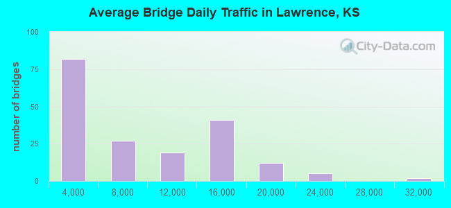
- 1,366,918Total average daily traffic
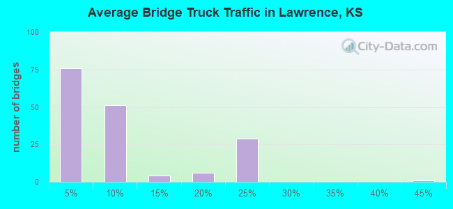
- 134,416Total average daily truck traffic
- National Bridge Inventory (NBI) Registered Bridges for Lawrence
- No street view available for this location
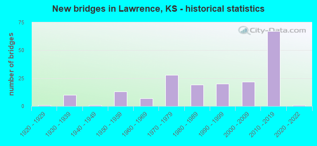
- New bridges - historical statistics
- 11920-1929
- 101930-1939
- 11940-1949
- 131950-1959
- 71960-1969
- 281970-1979
- 191980-1989
- 201990-1999
- 222000-2009
- 672010-2019
- 12020-2022
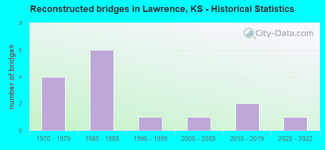
- Reconstructed bridges - Historical Statistics
- 41970-1979
- 61980-1989
- 11990-1999
- 12000-2009
- 22010-2019
- 12020-2022
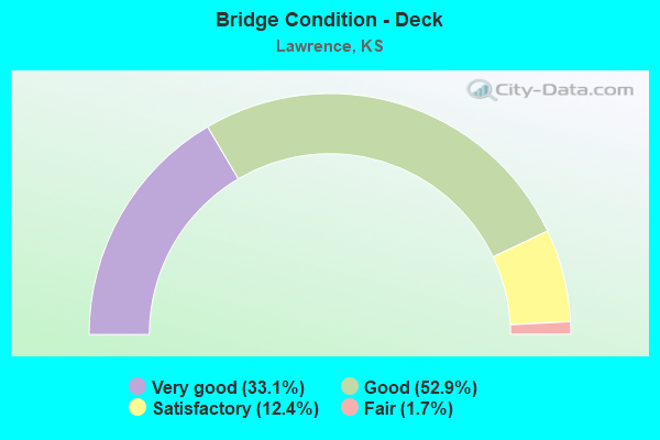
- Bridge Condition - Deck
- 33.1%Very good
- 52.9%Good
- 12.4%Satisfactory
- 1.7%Fair
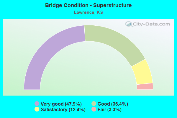
- Bridge Condition - Superstructure
- 47.9%Very good
- 36.4%Good
- 12.4%Satisfactory
- 3.3%Fair
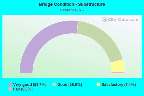
- Bridge Condition - Substructure
- 53.7%Very good
- 38.0%Good
- 7.4%Satisfactory
- 0.8%Fair
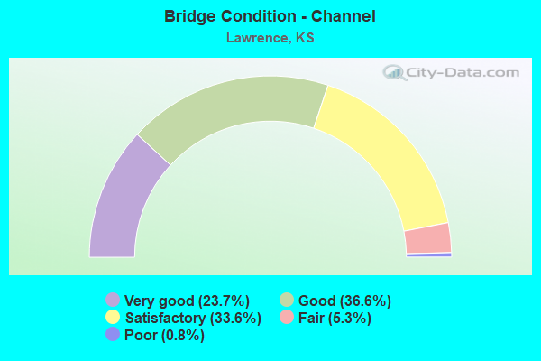
- Bridge Condition - Channel
- 23.7%Very good
- 36.6%Good
- 33.6%Satisfactory
- 5.3%Fair
- 0.8%Poor
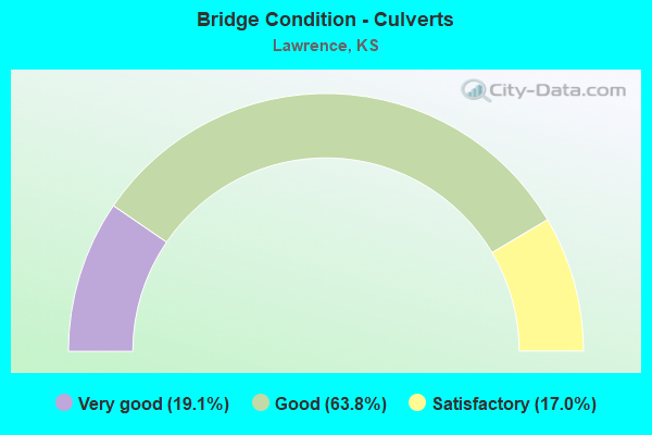
- Bridge Condition - Culverts
- 19.1%Very good
- 63.8%Good
- 17.0%Satisfactory
Find on map >> Show street view
Structure Number: 999907000231513, Location: 1.08 MI E US-40 & US-59 (Lat: 38.993889, Lng: -95.213056), Route carried "on" structure: Interstate 70, Year Built: 2010, Status: Open, Structure Length: 6.90m (22.64ft), Average Daily Traffic: 13,364 (year 2020), Truck Traffic: 22%, Average Future Daily Traffic: 20,652 (year 2041), Design Load: HS 25 or greater, Features Intersected: NATURAL LAKE DRAINAGE
Minimum Vertical Clearance: 30.47m (99.97ft), Kilometerpoint: 25.497, Lanes on structure: 3, Base Highway Network: Yes, Toll: On Interstate toll segment, Owner: State Toll Authority, Approaching Roadway Width: 21.1m (69.2ft), Material/Design: Concrete continuous, Design/Construction: Slab, Number Of Spans In Main Unit: 4, Length of Maximum Span: 19.5m (64.0ft), Curb-To-Curb Width: 21.1m (69.2ft), Out-to-Out Width: 21.7m (71.2ft)
Condition: Deck: Good, Superstructure: Very good, Substructure: Very good, Channel: Very good, Operating Rating: 74.1 metric tons, Method Used To Determine Operating Rating: Load Factor (LF), Inventory Rating: 44.4 metric tons, Method Used To Determine Inventory Rating: Load Factor (LF), Structural Evaluation: Equal to present desirable criteria, Deck Geometry: Superior to present desirable criteria, Waterway Adequacy: Equal to present desirable criteria, Approach Roadway Alignment: Equal to present desirable criteria, Length Of Structure Improvement: 22.65m (74.31ft), Designated Inspection Frequency: Every 24 months, Inspection Date: June 2020, Deck Structure Type: Concrete Cast-file-Place, Wearing Surface/Protective System: Wearing Surface: Monolithic Concrete, Deck Protection: Epoxy Coated Reinforcing
Find on map >> Show street view
Structure Number: 999907000231583, Location: 0.56 MI W U40&U59(WBI70) (Lat: 38.992222, Lng: -95.238611), Route carried "on" structure: Interstate 70, Year Built: 2011, Status: Open, Structure Length: 71.09m (233.23ft), Average Daily Traffic: 13,326 (year 2020), Truck Traffic: 22%, Average Future Daily Traffic: 20,593 (year 2041), Design Load: HL 93, Features Intersected: KANSAS RIVER, UP RR
Minimum Vertical Clearance: 30.47m (99.97ft), Kilometerpoint: 23.192, Lanes on structure: 3, Base Highway Network: Yes, Toll: On Interstate toll segment, Owner: State Toll Authority, Approaching Roadway Width: 17.1m (56.1ft), Skew: 1 degrees, Material/Design: Steel continuous, Design/Construction: Stringer/Multi-beam, Number Of Spans In Main Unit: 8, Number Of Approach Spans: 4, Length of Maximum Span: 76.2m (250.0ft), Curb-To-Curb Width: 17.1m (56.1ft), Out-to-Out Width: 17.7m (58.1ft)
Condition: Deck: Good, Superstructure: Very good, Substructure: Very good, Channel: Good, Operating Rating: 86.2 metric tons, Method Used To Determine Operating Rating: Load Factor (LF), Inventory Rating: 51.7 metric tons, Method Used To Determine Inventory Rating: Load Factor (LF), Structural Evaluation: Equal to present desirable criteria, Deck Geometry: Equal to present minimum criteria, Waterway Adequacy: Better than present minimum criteria, Approach Roadway Alignment: Equal to present desirable criteria, Length Of Structure Improvement: 233.23m (765.19ft), Designated Inspection Frequency: Every 24 months, Underwater Inspection Frequency: Every 60 months, Inspection Date: June 2020, Underwater Inspection Date: September 2017, Wearing Surface/Protective System: Wearing Surface: Monolithic Concrete, Deck Protection: Epoxy Coated Reinforcing
Find on map >> Show street view
Structure Number: 999907000231593, Location: 0.55 MI W U40&U59(EB 170) (Lat: 38.991944, Lng: -95.238611), Route carried "on" structure: Interstate 70, Year Built: 2011, Status: Open, Structure Length: 71.08m (233.20ft), Average Daily Traffic: 13,326 (year 2020), Truck Traffic: 22%, Average Future Daily Traffic: 20,593 (year 2041), Design Load: HL 93, Features Intersected: KANSAS RIVER, UP RR
Minimum Vertical Clearance: 30.47m (99.97ft), Kilometerpoint: 23.216, Lanes on structure: 3, Base Highway Network: Yes, Toll: On Interstate toll segment, Owner: State Toll Authority, Approaching Roadway Width: 17.1m (56.1ft), Skew: 1 degrees, Material/Design: Steel continuous, Design/Construction: Stringer/Multi-beam, Number Of Spans In Main Unit: 8, Number Of Approach Spans: 4, Length of Maximum Span: 76.2m (250.0ft), Curb-To-Curb Width: 17.1m (56.1ft), Out-to-Out Width: 17.7m (58.1ft)
Condition: Deck: Very good, Superstructure: Very good, Substructure: Very good, Channel: Very good, Operating Rating: 86.2 metric tons, Method Used To Determine Operating Rating: Load Factor (LF), Inventory Rating: 51.7 metric tons, Method Used To Determine Inventory Rating: Load Factor (LF), Structural Evaluation: Equal to present desirable criteria, Deck Geometry: Equal to present minimum criteria, Waterway Adequacy: Equal to present desirable criteria, Approach Roadway Alignment: Equal to present desirable criteria, Length Of Structure Improvement: 233.19m (765.06ft), Designated Inspection Frequency: Every 24 months, Underwater Inspection Frequency: Every 60 months, Inspection Date: June 2020, Underwater Inspection Date: September 2017, Wearing Surface/Protective System: Wearing Surface: Epoxy Overlay, Deck Protection: Epoxy Coated Reinforcing
Find on map >> Show street view
Structure Number: 999907000231603, Location: 1.52 MI W US-40 & 59 (Lat: 38.990000, Lng: -95.261111), Route carried "on" structure: Interstate 70, Year Built: 2007, Status: Open, Structure Length: 0.74m (2.43ft), Average Daily Traffic: 12,773 (year 2020), Truck Traffic: 22%, Average Future Daily Traffic: 18,980 (year 2041), Design Load: HS 25 or greater, Features Intersected: DRAINAGE
Minimum Vertical Clearance: 30.47m (99.97ft), Kilometerpoint: 21.301, Lanes on structure: 6, Base Highway Network: Yes, Toll: On Interstate toll segment, Owner: State Toll Authority, Approaching Roadway Width: 58.2m (190.9ft), Skew: 30 degrees, Material/Design: Concrete, Design/Construction: Culvert, Number Of Spans In Main Unit: 3, Length of Maximum Span: 2.1m (6.9ft), Curb-To-Curb Width: 58.2m (190.9ft), Out-to-Out Width: 59.8m (196.2ft)
Condition: Channel: Good, Culverts: Very good, Operating Rating: 89.8 metric tons, Method Used To Determine Operating Rating: Load Factor (LF), Inventory Rating: 89.8 metric tons, Method Used To Determine Inventory Rating: Load Factor (LF), Structural Evaluation: Equal to present desirable criteria, Deck Geometry: Superior to present desirable criteria, Waterway Adequacy: Equal to present desirable criteria, Approach Roadway Alignment: Equal to present desirable criteria, Length Of Structure Improvement: 2.43m (7.97ft), Designated Inspection Frequency: Every 24 months, Inspection Date: June 2020, Deck Structure Type: Concrete Cast-file-Place, Wearing Surface/Protective System: Wearing Surface: Bituminous, Deck Protection: Epoxy Coated Reinforcing
Find on map >> Show street view
Structure Number: 999907000520303, Location: 0.24 MI E DOUGLAS CO LINE (Lat: 38.998056, Lng: -95.182500), Route carried "on" structure: Interstate 70, Year Built: 1956, Year Reconstructed: 1985, Status: Open, Structure Length: 5.23m (17.16ft), Average Daily Traffic: 13,364 (year 2020), Truck Traffic: 22%, Average Future Daily Traffic: 20,652 (year 2041), Design Load: HS 20+Mod, Features Intersected: MUD CREEK
Minimum Vertical Clearance: 30.47m (99.97ft), Kilometerpoint: 0.367, Lanes on structure: 2, Base Highway Network: Yes, Toll: On Interstate toll segment, Owner: State Toll Authority, Approaching Roadway Width: 11.0m (36.1ft), Material/Design: Steel continuous, Design/Construction: Stringer/Multi-beam, Number Of Spans In Main Unit: 3, Length of Maximum Span: 19.8m (65.0ft), Curb-To-Curb Width: 9.8m (32.2ft), Out-to-Out Width: 10.5m (34.4ft)
Condition: Deck: Good, Superstructure: Good, Substructure: Good, Channel: Very good, Operating Rating: 49.2 metric tons, Method Used To Determine Operating Rating: Load Factor (LF), Inventory Rating: 28.6 metric tons, Method Used To Determine Inventory Rating: Load Factor (LF), Structural Evaluation: Better than present minimum criteria, Deck Geometry: High priority of replacement, Waterway Adequacy: Equal to present minimum criteria, Approach Roadway Alignment: Equal to present minimum criteria, Length Of Structure Improvement: 17.15m (56.27ft), Designated Inspection Frequency: Every 24 months, Inspection Date: June 2020, Wearing Surface/Protective System: Wearing Surface: Epoxy Overlay
Find on map >> Show street view
Structure Number: 999907000520313, Location: 0.25 MI E DOUGLAS CO LINE (Lat: 38.998056, Lng: -95.182500), Route carried "on" structure: Interstate 70, Year Built: 1956, Year Reconstructed: 1985, Status: Open, Structure Length: 5.23m (17.16ft), Average Daily Traffic: 13,364 (year 2020), Truck Traffic: 22%, Average Future Daily Traffic: 20,652 (year 2041), Design Load: HS 20+Mod, Features Intersected: MUD CREEK
Minimum Vertical Clearance: 30.47m (99.97ft), Kilometerpoint: 0.360, Lanes on structure: 2, Base Highway Network: Yes, Toll: On Interstate toll segment, Owner: State Toll Authority, Approaching Roadway Width: 11.0m (36.1ft), Material/Design: Steel continuous, Design/Construction: Stringer/Multi-beam, Number Of Spans In Main Unit: 3, Length of Maximum Span: 19.8m (65.0ft), Curb-To-Curb Width: 9.8m (32.2ft), Out-to-Out Width: 10.5m (34.4ft)
Condition: Deck: Good, Superstructure: Good, Substructure: Good, Channel: Good, Operating Rating: 49.2 metric tons, Method Used To Determine Operating Rating: Load Factor (LF), Inventory Rating: 28.6 metric tons, Method Used To Determine Inventory Rating: Load Factor (LF), Structural Evaluation: Better than present minimum criteria, Deck Geometry: High priority of replacement, Waterway Adequacy: Equal to present minimum criteria, Approach Roadway Alignment: Equal to present minimum criteria, Length Of Structure Improvement: 17.15m (56.27ft), Designated Inspection Frequency: Every 24 months, Inspection Date: June 2020, Deck Structure Type: Concrete Cast-file-Place, Wearing Surface/Protective System: Wearing Surface: Epoxy Overlay
Find on map >> Show street view
Structure Number: 999901000230691, Location: 6.11 MI E OF US-59 JCT (Lat: 38.935000, Lng: -95.149167), Route carried "under" structure: State highway 10, Year Built: 1977, Structure Length: 0. m, Average Daily Traffic: 14,092 (year 2020), Truck Traffic: 6%, Features Intersected: K-10 HIGHWAY, Facility Carried by Structure: RS1374
Minimum Vertical Clearance: 4.83m (15.85ft), Kilometerpoint: 24.047, Lanes on structure: 2, Lanes under structure: 4, Material/Design: Concrete continuous, Design/Construction: Box Beam or Girders - Multiple, Length of Maximum Span: 26.5m (86.9ft)
Find on map >> Show street view
Structure Number: 999901000230851, Location: K-10 OVER I-70 KTA (Lat: 38.996389, Lng: -95.343611), Route carried "under" structure: Interstate 70, Year Built: 1995, Structure Length: 0. m, Average Daily Traffic: 21,504 (year 2020), Truck Traffic: 17%, Features Intersected: I-70HWY WB&EB KTA, Facility Carried by Structure: K-10 HWY
Minimum Vertical Clearance: 4.82m (15.81ft), Kilometerpoint: 13.988, Lanes on structure: 2, Lanes under structure: 7, Toll: On Interstate toll segment, Material/Design: Steel continuous, Design/Construction: Stringer/Multi-beam, Length of Maximum Span: 37.8m (124.0ft)
Find on map >> Show street view
Structure Number: 999901000230931, Location: K-10 BYPASS/US-59 JCT (Lat: 38.919722, Lng: -95.260278), Route carried "under" structure: US 59, Year Built: 1996, Structure Length: 0. m, Average Daily Traffic: 9,097 (year 2020), Truck Traffic: 4%, Features Intersected: US40/US-59 HWY, Facility Carried by Structure: K-10 HWY
Minimum Vertical Clearance: 5.16m (16.93ft), Kilometerpoint: 28.366, Lanes on structure: 2, Lanes under structure: 4, Material/Design: Prestressed concrete continuous, Design/Construction: Stringer/Multi-beam, Length of Maximum Span: 27.4m (89.9ft)
Find on map >> Show street view
Structure Number: 999901000231631, Location: 0.54 MI E OF US-59 JCT (Lat: 38.921944, Lng: -95.250833), Route carried "under" structure: State highway 10, Year Built: 2014, Structure Length: 0. m, Average Daily Traffic: 10,253 (year 2020), Truck Traffic: 4%, Features Intersected: K10 HWY, Facility Carried by Structure: MICHIGAN STREET
Minimum Vertical Clearance: 5.35m (17.55ft), Kilometerpoint: 14.594, Lanes on structure: 2, Lanes under structure: 4, Material/Design: Prestressed concrete continuous, Design/Construction: Stringer/Multi-beam, Length of Maximum Span: 32.6m (107.0ft)
Find on map >> Show street view
Structure Number: 999901000231811, Location: 4.86 MI E OF US-59 JCT (Lat: 38.931389, Lng: -95.176667), Route carried "under" structure: Ramp State highway 16, Year Built: 2014, Structure Length: 0. m, Average Daily Traffic: 10,102 (year 2020), Truck Traffic: 4%, Features Intersected: K-10 & RAMP EB K-10-WB23, Facility Carried by Structure: E 1750 ROAD
Minimum Vertical Clearance: 5.16m (16.93ft), Kilometerpoint: 21.560, Lanes on structure: 2, Lanes under structure: 2, Material/Design: Steel continuous, Design/Construction: Stringer/Multi-beam, Length of Maximum Span: 43.9m (144.0ft)
Find on map >> Show street view
Structure Number: 999901000231831, Location: 4.97 MI E OF US-59 JCT (Lat: 38.935556, Lng: -95.171944), Route carried "under" structure: Ramp State highway 16, Year Built: 2014, Structure Length: 0. m, Average Daily Traffic: 10,102 (year 2020), Truck Traffic: 6%, Features Intersected: K-10 & RAMP EB23-EB K10, Facility Carried by Structure: FLYOVER EBK10-WB23
Minimum Vertical Clearance: 5.12m (16.80ft), Kilometerpoint: 22.038, Lanes on structure: 1, Lanes under structure: 1, Material/Design: Steel continuous, Design/Construction: Stringer/Multi-beam, Length of Maximum Span: 58.0m (190.3ft)
Find on map >> Show street view
Structure Number: 999901000231841, Location: 5.04 MI E OF US-59 JCT (Lat: 38.934444, Lng: -95.170833), Route carried "under" structure: Ramp State highway 16, Year Built: 2014, Structure Length: 0. m, Average Daily Traffic: 10,102 (year 2020), Truck Traffic: 4%, Features Intersected: K-10 HWY, Facility Carried by Structure: RAMP EB23-EBK10
Minimum Vertical Clearance: 5.42m (17.78ft), Kilometerpoint: 22.167, Lanes on structure: 1, Lanes under structure: 4, Material/Design: Steel continuous, Design/Construction: Stringer/Multi-beam, Length of Maximum Span: 56.4m (185.0ft)
Find on map >> Show street view
Structure Number: 999901000231911, Location: 0.82 MI S OF US40/K10 JCT (Lat: 38.959444, Lng: -95.334167), Route carried "under" structure: US 40, Year Built: 2015, Structure Length: 0. m, Average Daily Traffic: 17,981 (year 2020), Truck Traffic: 6%, Features Intersected: U-40 HWY, Facility Carried by Structure: BOB BILLINGS PRKWY
Minimum Vertical Clearance: 5.33m (17.49ft), Kilometerpoint: 19.006, Lanes on structure: 4, Lanes under structure: 2, Material/Design: Steel continuous, Design/Construction: Stringer/Multi-beam, Length of Maximum Span: 29.6m (97.1ft)
Find on map >> Show street view
Structure Number: 999903200520881, Location: 0.55 MI NE DOUGLAS CL (Lat: 39.000278, Lng: -95.177500), Route carried "under" structure: Interstate 70, Year Built: 2016, Structure Length: 0. m, Average Daily Traffic: 16,205 (year 2020), Truck Traffic: 20%, Features Intersected: I-70 HWY (KTA), Facility Carried by Structure: K-32 HWY
Minimum Vertical Clearance: 4.97m (16.31ft), Kilometerpoint: 0.866, Lanes on structure: 2, Lanes under structure: 4, Toll: On Interstate toll segment, Material/Design: Steel continuous, Design/Construction: Stringer/Multi-beam, Length of Maximum Span: 50.3m (165.0ft)
Find on map >> Show street view
Structure Number: 999904000230064, Location: 1.48 MI SOUTH OF 59 N JCT (Lat: 38.979167, Lng: -95.235278), Route carried "under" structure: US 40, Year Built: 1937, Structure Length: 0. m, Average Daily Traffic: 14,100 (year 2020), Truck Traffic: 7%, Features Intersected: US40 HWY, Facility Carried by Structure: UP RAILROAD
Minimum Vertical Clearance: 4.27m (14.01ft), Kilometerpoint: 37.091, Lanes under structure: 4, Material/Design: Steel, Design/Construction: Stringer/Multi-beam, Length of Maximum Span: 13.7m (44.9ft)
Find on map >> Show street view
Structure Number: 999904000230881, Location: US-40/K-10 JCT (Lat: 38.971389, Lng: -95.334167), Route carried "under" structure: State highway 10, Year Built: 1996, Structure Length: 0. m, Average Daily Traffic: 17,577 (year 2020), Truck Traffic: 4%, Features Intersected: K-10 HWY, Facility Carried by Structure: US-40 HWY
Minimum Vertical Clearance: 5.64m (18.50ft), Kilometerpoint: 3.187, Lanes on structure: 4, Lanes under structure: 2, Material/Design: Prestressed concrete continuous, Design/Construction: Stringer/Multi-beam, Length of Maximum Span: 36.6m (120.1ft)
Find on map >> Show street view
Structure Number: 999905900230221, Location: 0.75 MI N K10 (Lat: 38.953333, Lng: -95.260278), Route carried "under" structure: US 40, Year Built: 1966, Structure Length: 0. m, Average Daily Traffic: 28,835 (year 2020), Truck Traffic: 4%, Features Intersected: US40/US59 HWY, Facility Carried by Structure: IRVING HILL ROAD
Minimum Vertical Clearance: 4.48m (14.70ft), Kilometerpoint: 32.106, Lanes on structure: 2, Lanes under structure: 4, Material/Design: Steel continuous, Design/Construction: Stringer/Multi-beam, Length of Maximum Span: 25.0m (82.0ft)
Find on map >> Show street view
Structure Number: 999905900231171, Location: 6.2 MI N JCT US-56/US-59 (Lat: 38.869722, Lng: -95.255833), Route carried "under" structure: US 59, Year Built: 2012, Structure Length: 0. m, Average Daily Traffic: 5,253 (year 2020), Truck Traffic: 6%, Features Intersected: US-59 HIGHWAY NB-SB, Facility Carried by Structure: 900N ROAD
Minimum Vertical Clearance: 5.42m (17.78ft), Kilometerpoint: 14.754, Lanes on structure: 2, Lanes under structure: 4, Material/Design: Steel continuous, Design/Construction: Stringer/Multi-beam, Length of Maximum Span: 30.5m (100.1ft)
Find on map >> Show street view
Structure Number: 999907000230363, Location: 10.17 MI E SHAWNEE CL (Lat: 38.997778, Lng: -95.316389), Route carried "under" structure: Interstate 70, Year Built: 1956, Structure Length: 0. m, Average Daily Traffic: 15,403 (year 2020), Truck Traffic: 20%, Features Intersected: I-70 HWY (KTA), Facility Carried by Structure: LOCAL ROAD
Minimum Vertical Clearance: 4.49m (14.73ft), Kilometerpoint: 16.377, Lanes on structure: 2, Lanes under structure: 4, Toll: On Interstate toll segment, Material/Design: Steel continuous, Design/Construction: Girder and Floorbeam System, Length of Maximum Span: 14.0m (45.9ft)
Find on map >> Show street view
Structure Number: 999907000231263, Location: 8.14 MI E SHAWNEE CO LN (Lat: 38.996944, Lng: -95.353889), Route carried "under" structure: Interstate 70, Year Built: 2004, Structure Length: 0. m, Average Daily Traffic: 21,504 (year 2020), Truck Traffic: 17%, Features Intersected: I-70 HWY (KTA), Facility Carried by Structure: LOCAL ROAD
Minimum Vertical Clearance: 5.13m (16.83ft), Kilometerpoint: 13.113, Lanes on structure: 2, Lanes under structure: 6, Toll: On Interstate toll segment, Material/Design: Steel continuous, Design/Construction: Stringer/Multi-beam, Length of Maximum Span: 25.0m (82.0ft)
Find on map >> Show street view
Structure Number: 999907000231273, Location: 12.19 MI E SHAWNEE CL (Lat: 38.995278, Lng: -95.278889), Route carried "under" structure: Interstate 70, Year Built: 2006, Structure Length: 0. m, Average Daily Traffic: 15,403 (year 2020), Truck Traffic: 20%, Features Intersected: I-70 HWY (KTA), Facility Carried by Structure: URB3203
Minimum Vertical Clearance: 5.02m (16.47ft), Kilometerpoint: 19.653, Lanes on structure: 2, Lanes under structure: 4, Toll: On Interstate toll segment, Material/Design: Prestressed concrete continuous, Design/Construction: Stringer/Multi-beam, Length of Maximum Span: 27.4m (89.9ft)
Find on map >> Show street view
Structure Number: 999907000231373, Location: 13.26 MI E SHAWNEE CL (Lat: 38.990000, Lng: -95.260278), Route carried "under" structure: Ramp State highway 9, Year Built: 2008, Structure Length: 0. m, Average Daily Traffic: 15,403 (year 2020), Truck Traffic: 21%, Features Intersected: I-70 HWY (KTA), Facility Carried by Structure: URB3213-IOWA ST
Minimum Vertical Clearance: 5.29m (17.36ft), Kilometerpoint: 21.372, Lanes on structure: 2, Lanes under structure: 7, Toll: On toll road, Material/Design: Steel continuous, Design/Construction: Stringer/Multi-beam, Length of Maximum Span: 30.5m (100.1ft)
Find on map >> Show street view
Structure Number: 999907000231383, Location: 0.98 MI W US-40 & 59 (Lat: 38.990278, Lng: -95.251111), Route carried "under" structure: Ramp State highway 9, Year Built: 2009, Structure Length: 0. m, Average Daily Traffic: 16,041 (year 2020), Truck Traffic: 21%, Features Intersected: I-70 HWY (KTA), Facility Carried by Structure: URB3221-MCHGN ST
Minimum Vertical Clearance: 5.41m (17.75ft), Kilometerpoint: 22.183, Lanes on structure: 2, Lanes under structure: 6, Toll: On toll road, Material/Design: Steel continuous, Design/Construction: Stringer/Multi-beam, Length of Maximum Span: 29.0m (95.1ft)
Find on map >> Show street view
Structure Number: 999907000231393, Location: 1.31 MI W US-40 & 59 (Lat: 38.989722, Lng: -95.257222), Route carried "under" structure: Interstate 70, Year Built: 2009, Structure Length: 0. m, Average Daily Traffic: 15,403 (year 2020), Truck Traffic: 20%, Features Intersected: I-70 KTA, Facility Carried by Structure: W LAWRENCE INTR
Minimum Vertical Clearance: 5.10m (16.73ft), Kilometerpoint: 21.647, Lanes on structure: 2, Lanes under structure: 6, Toll: On Interstate toll segment, Material/Design: Steel continuous, Design/Construction: Stringer/Multi-beam, Length of Maximum Span: 25.0m (82.0ft)
Find on map >> Show street view
Structure Number: 999907000231423, Location: JCT I70 (KTA)/US40 & 59 (Lat: 38.992778, Lng: -95.233333), Route carried "under" structure: US 40, Year Built: 2010, Structure Length: 0. m, Average Daily Traffic: 10,960 (year 2020), Truck Traffic: 12%, Features Intersected: US-40 & 59 HWY, Facility Carried by Structure: I-70 HWY EB (KTA)
Minimum Vertical Clearance: 5.18m (16.99ft), Kilometerpoint: 38.615, Lanes on structure: 4, Lanes under structure: 4, Material/Design: Steel continuous, Design/Construction: Stringer/Multi-beam, Length of Maximum Span: 31.1m (102.0ft)
Find on map >> Show street view
Structure Number: 999907000231433, Location: JCT I70 (KTA)/US40 & 59 (Lat: 38.993056, Lng: -95.233333), Route carried "under" structure: US 40, Year Built: 2010, Structure Length: 0. m, Average Daily Traffic: 10,960 (year 2020), Truck Traffic: 12%, Features Intersected: US-40 & 59 HWY, Facility Carried by Structure: I-70 HWY WB (KTA)
Minimum Vertical Clearance: 5.12m (16.80ft), Kilometerpoint: 38.632, Lanes on structure: 4, Lanes under structure: 4, Material/Design: Steel continuous, Design/Construction: Stringer/Multi-beam, Length of Maximum Span: 31.1m (102.0ft)