Bridge Statistics for Lebanon, Oregon (OR)
Condition, Traffic, Stress, Structural Evaluation, Project Costs
- National Bridge Inventory (NBI) Statistics
- 43Number of bridges
- 279ft / 85.2mTotal length
- $1,754,000Total costs
- 124,478Total average daily traffic
- 13,267Total average daily truck traffic
- 175,693Total future (year 2040) average daily traffic
- National Bridge Inventory (NBI) Registered Bridges for Lebanon
- No street view available for this location
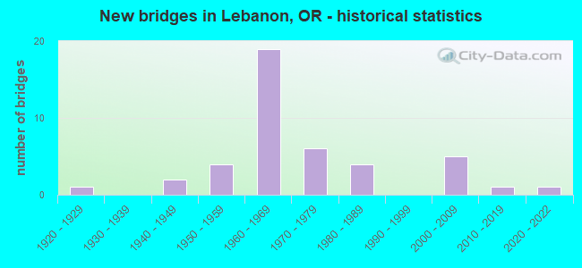
- New bridges - historical statistics
- 11920-1929
- 21940-1949
- 41950-1959
- 191960-1969
- 61970-1979
- 41980-1989
- 52000-2009
- 12010-2019
- 12020-2022

- Reconstructed bridges - Historical Statistics
- 11960-1969
- 01970-1979
- 01980-1989
- 31990-1999
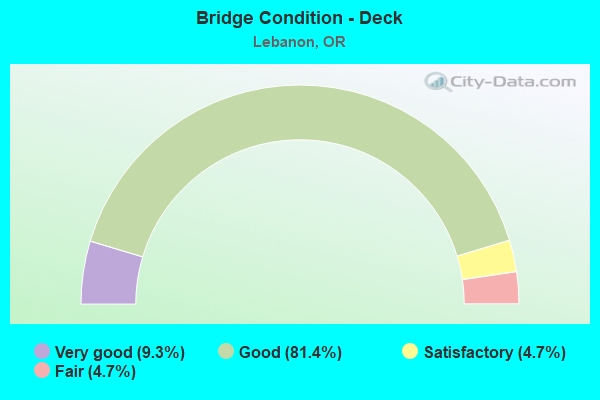
- Bridge Condition - Deck
- 9.3%Very good
- 81.4%Good
- 4.7%Satisfactory
- 4.7%Fair
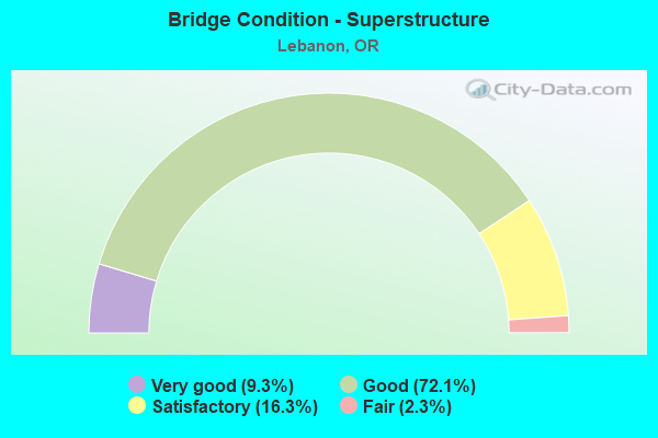
- Bridge Condition - Superstructure
- 9.3%Very good
- 72.1%Good
- 16.3%Satisfactory
- 2.3%Fair
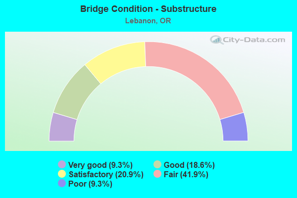
- Bridge Condition - Substructure
- 9.3%Very good
- 18.6%Good
- 20.9%Satisfactory
- 41.9%Fair
- 9.3%Poor
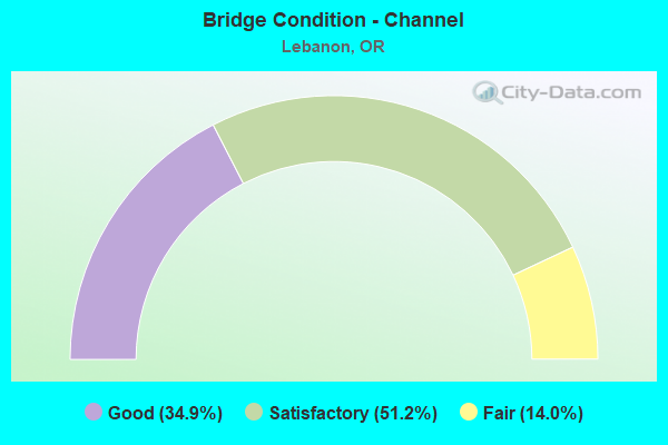
- Bridge Condition - Channel
- 34.9%Good
- 51.2%Satisfactory
- 14.0%Fair
Find on map >> Show street view
Structure Number: 578A016 01355, Location: 010 MI SE LEBANON N C LMT (Lat: 44.534958, Lng: -122.907053), Route carried "on" structure: US 20, Year Built: 1921, Year Reconstructed: 1960, Status: Open, Structure Length: 1.22m (4.00ft), Average Daily Traffic: 15,212 (year 2020), Truck Traffic: 12%, Average Future Daily Traffic: 22,500 (year 2040), Design Load: H 15, Features Intersected: Lebanon Ditch
Minimum Vertical Clearance: 30+ m (98+ ft), Kilometerpoint: 21.807, Lanes on structure: 2, Base Highway Network: Yes, Owner: State Highway Agency, Approaching Roadway Width: 12.2m (40.0ft), Skew: 2 degrees, Material/Design: Prestressed concrete, Design/Construction: Stringer/Multi-beam, Number Of Spans In Main Unit: 1, Length of Maximum Span: 12.2m (40.0ft), Curb or Sidewalk Widths: Left: 1.5m (4.9ft), Right: 1.5m (4.9ft), Curb-To-Curb Width: 12.2m (40.0ft), Out-to-Out Width: 15.8m (51.8ft)
Condition: Deck: Satisfactory, Superstructure: Satisfactory, Substructure: Poor, Channel: Good, Operating Rating: 36.9 metric tons, Method Used To Determine Operating Rating: Load and Resistance Factor Rating (LRFR) rating reported by rating factor(RF) method using HL-93 loadings, Inventory Rating: 28.5 metric tons, Method Used To Determine Inventory Rating: Load and Resistance Factor Rating (LRFR) rating reported by rating factor(RF) method using HL-93 loadings, Structural Evaluation: Meets minimum limits, Deck Geometry: Better than present minimum criteria, Waterway Adequacy: Equal to present desirable criteria, Approach Roadway Alignment: Equal to present desirable criteria, Designated Inspection Frequency: Every 24 months, Underwater Inspection Frequency: Every 60 months, Inspection Date: Febuary 2020, Underwater Inspection Date: July 2018, Deck Structure Type: Concrete Cast-file-Place, Wearing Surface/Protective System: Wearing Surface: Bituminous
Find on map >> Show street view
Structure Number: 1162A016 01189, Location: 006 MI NW LEBANON (Lat: 44.558597, Lng: -122.911694), Route carried "on" structure: US 20, Year Built: 1950, Status: Open, Structure Length: 2.83m (9.28ft), Average Daily Traffic: 9,867 (year 2020), Truck Traffic: 11%, Average Future Daily Traffic: 15,400 (year 2040), Design Load: HS 15, Features Intersected: Mt. States Power Canal
Minimum Vertical Clearance: 30+ m (98+ ft), Kilometerpoint: 19.135, Lanes on structure: 2, Base Highway Network: Yes, Owner: State Highway Agency, Approaching Roadway Width: 7.9m (25.9ft), Skew: 4 degrees, Material/Design: Concrete continuous, Design/Construction: Stringer/Multi-beam, Number Of Spans In Main Unit: 3, Length of Maximum Span: 9.4m (30.8ft), Curb or Sidewalk Widths: Left: 1.1m (3.6ft), Right: 1.1m (3.6ft), Curb-To-Curb Width: 7.9m (25.9ft), Out-to-Out Width: 10.8m (35.4ft)
Condition: Deck: Satisfactory, Superstructure: Satisfactory, Substructure: Satisfactory, Channel: Satisfactory, Operating Rating: 29.5 metric tons, Method Used To Determine Operating Rating: Load and Resistance Factor Rating (LRFR) rating reported by rating factor(RF) method using HL-93 loadings, Inventory Rating: 22.7 metric tons, Method Used To Determine Inventory Rating: Load and Resistance Factor Rating (LRFR) rating reported by rating factor(RF) method using HL-93 loadings, Structural Evaluation: Somewhat better than minimum adequacy, Deck Geometry: High priority of replacement, Waterway Adequacy: Equal to present desirable criteria, Approach Roadway Alignment: Equal to present desirable criteria, Length Of Structure Improvement: 2.80m (9.19ft), Designated Inspection Frequency: Every 24 months, Inspection Date: Febuary 2020, Bridge Improvement Cost: $298,000, Roadway Improvement Cost: $30,000, Total Project Cost: $476,000, Deck Structure Type: Concrete Cast-file-Place, Wearing Surface/Protective System: Wearing Surface: Bituminous
Find on map >> Show street view
Structure Number: 4231A016 01406, Location: 009 MI NW LEBANON S C LMT (Lat: 44.527747, Lng: -122.907086), Route carried "on" structure: US 20, Year Built: 1961, Status: Open, Structure Length: 1.65m (5.41ft), Average Daily Traffic: 18,692 (year 2020), Truck Traffic: 5%, Average Future Daily Traffic: 26,500 (year 2040), Design Load: HS 20, Features Intersected: Mt. States Power Canal
Minimum Vertical Clearance: 30+ m (98+ ft), Kilometerpoint: 22.627, Lanes on structure: 4, Base Highway Network: Yes, Owner: State Highway Agency, Approaching Roadway Width: 19.5m (64.0ft), Skew: 20 degrees, Material/Design: Prestressed concrete, Design/Construction: Slab, Number Of Spans In Main Unit: 3, Length of Maximum Span: 5.5m (18.0ft), Curb or Sidewalk Widths: Left: 1.5m (4.9ft), Right: 1.5m (4.9ft), Curb-To-Curb Width: 19.5m (64.0ft), Out-to-Out Width: 23.2m (76.1ft)
Condition: Deck: Good, Superstructure: Good, Substructure: Fair, Channel: Good, Operating Rating: 28.5 metric tons, Method Used To Determine Operating Rating: Load and Resistance Factor Rating (LRFR) rating reported by rating factor(RF) method using HL-93 loadings, Inventory Rating: 22.0 metric tons, Method Used To Determine Inventory Rating: Load and Resistance Factor Rating (LRFR) rating reported by rating factor(RF) method using HL-93 loadings, Structural Evaluation: Somewhat better than minimum adequacy, Deck Geometry: Better than present minimum criteria, Waterway Adequacy: Equal to present desirable criteria, Approach Roadway Alignment: Equal to present desirable criteria, Designated Inspection Frequency: Every 24 months, Underwater Inspection Frequency: Every 60 months, Inspection Date: Febuary 2020, Underwater Inspection Date: May 2018, Deck Structure Type: Concrete Precast Panels, Wearing Surface/Protective System: Wearing Surface: Bituminous
Find on map >> Show street view
Structure Number: 7073 016 01356, Location: 010 MI SE LEBANON N C LMT (Lat: 44.535856, Lng: -122.905572), Route carried "on" structure: US 20, Year Built: 1947, Status: Open, Structure Length: 2.26m (7.41ft), Average Daily Traffic: 6,784 (year 2020), Truck Traffic: 12%, Average Future Daily Traffic: 9,600 (year 2040), Design Load: HS 15, Features Intersected: Lebanon Ditch
Minimum Vertical Clearance: 30+ m (98+ ft), Kilometerpoint: 21.823, Lanes on structure: 2, Base Highway Network: Yes, Owner: State Highway Agency, Approaching Roadway Width: 10.4m (34.1ft), Material/Design: Concrete continuous, Design/Construction: Tee Beam, Number Of Spans In Main Unit: 3, Length of Maximum Span: 13.4m (44.0ft), Curb-To-Curb Width: 10.4m (34.1ft), Out-to-Out Width: 11.9m (39.0ft)
Condition: Deck: Good, Superstructure: Satisfactory, Substructure: Satisfactory, Channel: Good, Operating Rating: 23.0 metric tons, Method Used To Determine Operating Rating: Load and Resistance Factor Rating (LRFR) rating reported by rating factor(RF) method using HL-93 loadings, Inventory Rating: 17.8 metric tons, Method Used To Determine Inventory Rating: Load and Resistance Factor Rating (LRFR) rating reported by rating factor(RF) method using HL-93 loadings, Structural Evaluation: Meets minimum limits, Deck Geometry: Somewhat better than minimum adequacy, Waterway Adequacy: Equal to present desirable criteria, Approach Roadway Alignment: Equal to present desirable criteria, Designated Inspection Frequency: Every 24 months, Inspection Date: Febuary 2020, Deck Structure Type: Concrete Cast-file-Place, Wearing Surface/Protective System: Wearing Surface: Bituminous
Find on map >> Show street view
Structure Number: 9951 000900951, Location: 1.3 MILES EAST HIGHWAY 20 (Lat: 44.587731, Lng: -122.898431), Route carried "on" structure: County highway A0491, Year Built: 1962, Status: Open, Structure Length: 1.37m (4.49ft), Average Daily Traffic: 360 (year 2021), Truck Traffic: 10%, Average Future Daily Traffic: 515 (year 2041), Design Load: HS 20, Features Intersected: SLOUGH, Facility Carried by Structure: TENNESSE SCH. ROAD
Minimum Vertical Clearance: 30+ m (98+ ft), Kilometerpoint: 15.305, Lanes on structure: 2, Owner: County Highway Agency, Approaching Roadway Width: 8.5m (27.9ft), Material/Design: Prestressed concrete, Design/Construction: Slab, Number Of Spans In Main Unit: 2, Length of Maximum Span: 6.7m (22.0ft), Curb or Sidewalk Widths: Left: 0.2m (0.7ft), Right: 0.2m (0.7ft), Curb-To-Curb Width: 8.6m (28.2ft), Out-to-Out Width: 9.1m (29.9ft)
Condition: Deck: Good, Superstructure: Good, Substructure: Good, Channel: Good, Operating Rating: 63.5 metric tons, Method Used To Determine Operating Rating: Load Factor (LF), Inventory Rating: 38.1 metric tons, Method Used To Determine Inventory Rating: Load Factor (LF), Structural Evaluation: Better than present minimum criteria, Deck Geometry: Equal to present minimum criteria, Waterway Adequacy: Equal to present desirable criteria, Approach Roadway Alignment: Equal to present desirable criteria, Designated Inspection Frequency: Every 24 months, Inspection Date: June 2021, Deck Structure Type: Other, Wearing Surface/Protective System: Wearing Surface: Bituminous
Find on map >> Show street view
Structure Number: 11967A071900076, Location: 0050 MILES SE CR 718 (Lat: 44.520492, Lng: -122.891597), Route carried "on" structure: County highway A0474, Year Built: 1983, Status: Temporarily open, Structure Length: 1.92m (6.30ft), Average Daily Traffic: 1,390 (year 2021), Truck Traffic: 10%, Average Future Daily Traffic: 1,947 (year 2041), Design Load: HS 20, Features Intersected: ALBANY-SANTIAM CANAL, Facility Carried by Structure: RIVER DR
Minimum Vertical Clearance: 30+ m (98+ ft), Kilometerpoint: 1.223, Lanes on structure: 2, Owner: County Highway Agency, Approaching Roadway Width: 9.1m (29.9ft), Skew: 4 degrees, Material/Design: Prestressed concrete, Design/Construction: Slab, Number Of Spans In Main Unit: 2, Length of Maximum Span: 9.4m (30.8ft), Curb or Sidewalk Widths: Left: 0.2m (0.7ft), Right: 0.2m (0.7ft), Curb-To-Curb Width: 10.4m (34.1ft), Out-to-Out Width: 11.0m (36.1ft)
Condition: Deck: Good, Superstructure: Good, Substructure: Poor, Channel: Satisfactory, Operating Rating: 88.9 metric tons, Method Used To Determine Operating Rating: Load Factor (LF), Inventory Rating: 53.5 metric tons, Method Used To Determine Inventory Rating: Load Factor (LF), Structural Evaluation: Meets minimum limits, Deck Geometry: Equal to present minimum criteria, Waterway Adequacy: Equal to present desirable criteria, Approach Roadway Alignment: Equal to present minimum criteria, Designated Inspection Frequency: Every 24 months, Underwater Inspection Frequency: Every 60 months, Inspection Date: July 2021, Underwater Inspection Date: March 2021, Deck Structure Type: Other, Wearing Surface/Protective System: Wearing Surface: Bituminous
Find on map >> Show street view
Structure Number: 11968 071900231, Location: 020 MILES EAST CR 719 (Lat: 44.515719, Lng: -122.861750), Route carried "on" structure: County highway A0474, Year Built: 1966, Year Reconstructed: 1999, Status: Open, Structure Length: 2.77m (9.09ft), Average Daily Traffic: 850 (year 2021), Truck Traffic: 10%, Average Future Daily Traffic: 1,184 (year 2041), Design Load: HS 20, Features Intersected: ALBANY-SANTIAM CANAL, Facility Carried by Structure: RIVER DR
Minimum Vertical Clearance: 30+ m (98+ ft), Kilometerpoint: 3.718, Lanes on structure: 2, Owner: County Highway Agency, Approaching Roadway Width: 9.8m (32.2ft), Material/Design: Prestressed concrete, Design/Construction: Slab, Number Of Spans In Main Unit: 3, Length of Maximum Span: 9.1m (29.9ft), Curb or Sidewalk Widths: Left: 0.2m (0.7ft), Right: 0.2m (0.7ft), Curb-To-Curb Width: 9.2m (30.2ft), Out-to-Out Width: 9.8m (32.2ft)
Condition: Deck: Good, Superstructure: Good, Substructure: Satisfactory, Channel: Satisfactory, Operating Rating: 28.2 metric tons, Method Used To Determine Operating Rating: Load and Resistance Factor Rating (LRFR) rating reported by rating factor(RF) method using HL-93 loadings, Inventory Rating: 21.7 metric tons, Method Used To Determine Inventory Rating: Load and Resistance Factor Rating (LRFR) rating reported by rating factor(RF) method using HL-93 loadings, Structural Evaluation: Somewhat better than minimum adequacy, Deck Geometry: Equal to present minimum criteria, Waterway Adequacy: Equal to present desirable criteria, Approach Roadway Alignment: Equal to present desirable criteria, Designated Inspection Frequency: Every 24 months, Inspection Date: June 2021, Deck Structure Type: Other, Wearing Surface/Protective System: Wearing Surface: Bituminous
Find on map >> Show street view
Structure Number: 11987 020L0015, Location: 015 MI EAST OF BREWSTER (Lat: 44.577139, Lng: -122.842081), Route carried "on" structure: County highway A0490, Year Built: 1969, Status: Open, Structure Length: 1.86m (6.10ft), Average Daily Traffic: 3,399 (year 2021), Truck Traffic: 10%, Average Future Daily Traffic: 4,764 (year 2041), Design Load: HS 20, Features Intersected: ONE HORSE SLOUGH, Facility Carried by Structure: LACOMB ROAD
Minimum Vertical Clearance: 30+ m (98+ ft), Kilometerpoint: 2.414, Lanes on structure: 2, Owner: County Highway Agency, Approaching Roadway Width: 8.5m (27.9ft), Skew: 4 degrees, Material/Design: Prestressed concrete, Design/Construction: Slab, Number Of Spans In Main Unit: 2, Length of Maximum Span: 9.1m (29.9ft), Curb or Sidewalk Widths: Left: 0.2m (0.7ft), Right: 0.2m (0.7ft), Curb-To-Curb Width: 10.4m (34.1ft), Out-to-Out Width: 11.0m (36.1ft)
Condition: Deck: Good, Superstructure: Good, Substructure: Good, Channel: Good, Operating Rating: 82.6 metric tons, Method Used To Determine Operating Rating: Load Factor (LF), Inventory Rating: 49.9 metric tons, Method Used To Determine Inventory Rating: Load Factor (LF), Structural Evaluation: Better than present minimum criteria, Deck Geometry: Somewhat better than minimum adequacy, Waterway Adequacy: Better than present minimum criteria, Approach Roadway Alignment: Equal to present desirable criteria, Designated Inspection Frequency: Every 24 months, Underwater Inspection Frequency: Every 60 months, Inspection Date: June 2021, Underwater Inspection Date: January 2020, Deck Structure Type: Other, Wearing Surface/Protective System: Wearing Surface: Bituminous
Find on map >> Show street view
Structure Number: 11992 066600378, Location: 006 MI S CR 20L (Lat: 44.569150, Lng: -122.834569), Route carried "on" structure: County highway C0666, Year Built: 1972, Status: Open, Structure Length: 1.37m (4.49ft), Average Daily Traffic: 360 (year 2021), Truck Traffic: 10%, Average Future Daily Traffic: 515 (year 2041), Design Load: HS 20, Features Intersected: ONEHOURSE SLOUGH, Facility Carried by Structure: BOND ROAD
Minimum Vertical Clearance: 30+ m (98+ ft), Kilometerpoint: 6.083, Lanes on structure: 2, Owner: County Highway Agency, Approaching Roadway Width: 7.9m (25.9ft), Material/Design: Prestressed concrete, Design/Construction: Slab, Number Of Spans In Main Unit: 2, Length of Maximum Span: 6.4m (21.0ft), Curb or Sidewalk Widths: Left: 0.2m (0.7ft), Right: 0.2m (0.7ft), Curb-To-Curb Width: 7.9m (25.9ft), Out-to-Out Width: 8.5m (27.9ft)
Condition: Deck: Good, Superstructure: Good, Substructure: Satisfactory, Channel: Satisfactory, Operating Rating: 71.7 metric tons, Method Used To Determine Operating Rating: Load Factor (LF), Inventory Rating: 28.1 metric tons, Method Used To Determine Inventory Rating: Load Factor (LF), Structural Evaluation: Equal to present minimum criteria, Deck Geometry: Somewhat better than minimum adequacy, Waterway Adequacy: Equal to present desirable criteria, Approach Roadway Alignment: Equal to present desirable criteria, Length Of Structure Improvement: 1.80m (5.91ft), Designated Inspection Frequency: Every 24 months, Inspection Date: June 2021, Bridge Improvement Cost: $187,000, Roadway Improvement Cost: $19,000, Total Project Cost: $299,000, Deck Structure Type: Other, Wearing Surface/Protective System: Wearing Surface: Bituminous
Find on map >> Show street view
Structure Number: 12629 073900083, Location: 008 MI WEST CR 777 (Lat: 44.515619, Lng: -122.926089), Route carried "on" structure: County highway A0493, Year Built: 1965, Status: Open, Structure Length: 1.52m (4.99ft), Average Daily Traffic: 1,030 (year 2021), Truck Traffic: 15%, Average Future Daily Traffic: 1,442 (year 2041), Design Load: HS 20, Features Intersected: OAK CREEK, Facility Carried by Structure: STOLTZ HILL RD
Minimum Vertical Clearance: 30+ m (98+ ft), Kilometerpoint: 1.336, Lanes on structure: 2, Owner: County Highway Agency, Approaching Roadway Width: 7.6m (24.9ft), Material/Design: Prestressed concrete, Design/Construction: Slab, Number Of Spans In Main Unit: 1, Length of Maximum Span: 14.9m (48.9ft), Curb or Sidewalk Widths: Left: 0.2m (0.7ft), Right: 0.2m (0.7ft), Curb-To-Curb Width: 7.6m (24.9ft), Out-to-Out Width: 8.2m (26.9ft)
Condition: Deck: Good, Superstructure: Good, Substructure: Fair, Channel: Satisfactory, Operating Rating: 62.2 metric tons, Method Used To Determine Operating Rating: Load and Resistance Factor Rating (LRFR) rating reported by rating factor(RF) method using HL-93 loadings, Inventory Rating: 48.0 metric tons, Method Used To Determine Inventory Rating: Load and Resistance Factor Rating (LRFR) rating reported by rating factor(RF) method using HL-93 loadings, Structural Evaluation: Somewhat better than minimum adequacy, Deck Geometry: Meets minimum limits, Waterway Adequacy: Equal to present desirable criteria, Approach Roadway Alignment: Equal to present desirable criteria, Designated Inspection Frequency: Every 24 months, Inspection Date: June 2021, Deck Structure Type: Other, Wearing Surface/Protective System: Wearing Surface: Bituminous
Find on map >> Show street view
Structure Number: 12646 040800011, Location: 0011 MILES SOUTH HWY 34 (Lat: 44.544561, Lng: -122.994389), Route carried "on" structure: County highway C0408, Year Built: 1969, Status: Open, Structure Length: 1.52m (4.99ft), Average Daily Traffic: 505 (year 2021), Truck Traffic: 10%, Average Future Daily Traffic: 721 (year 2041), Design Load: HS 20, Features Intersected: OAK CREEK, Facility Carried by Structure: STECKLEY RD
Minimum Vertical Clearance: 30+ m (98+ ft), Kilometerpoint: 0.177, Lanes on structure: 2, Owner: County Highway Agency, Approaching Roadway Width: 8.5m (27.9ft), Material/Design: Prestressed concrete, Design/Construction: Slab, Number Of Spans In Main Unit: 1, Length of Maximum Span: 14.9m (48.9ft), Curb or Sidewalk Widths: Left: 0.2m (0.7ft), Right: 0.2m (0.7ft), Curb-To-Curb Width: 9.1m (29.9ft), Out-to-Out Width: 9.8m (32.2ft)
Condition: Deck: Good, Superstructure: Satisfactory, Substructure: Satisfactory, Channel: Satisfactory, Operating Rating: 57.2 metric tons, Method Used To Determine Operating Rating: Load Factor (LF), Inventory Rating: 34.5 metric tons, Method Used To Determine Inventory Rating: Load Factor (LF), Structural Evaluation: Equal to present minimum criteria, Deck Geometry: Equal to present minimum criteria, Waterway Adequacy: Equal to present desirable criteria, Approach Roadway Alignment: Equal to present desirable criteria, Designated Inspection Frequency: Every 24 months, Inspection Date: October 2021, Deck Structure Type: Other, Wearing Surface/Protective System: Wearing Surface: Bituminous
Find on map >> Show street view
Structure Number: 12647 040800005, Location: 0005 MILES SOUTH HWY 34 (Lat: 44.545389, Lng: -122.994369), Route carried "on" structure: County highway C0408, Year Built: 1961, Status: Open, Structure Length: 0.91m (2.99ft), Average Daily Traffic: 505 (year 2021), Truck Traffic: 10%, Average Future Daily Traffic: 721 (year 2041), Design Load: HS 20, Features Intersected: OAK CREEK OVERFLOW, Facility Carried by Structure: STECKLEY RD
Minimum Vertical Clearance: 30+ m (98+ ft), Kilometerpoint: 0.080, Lanes on structure: 2, Owner: County Highway Agency, Approaching Roadway Width: 7.3m (24.0ft), Skew: 2 degrees, Material/Design: Prestressed concrete, Design/Construction: Slab, Number Of Spans In Main Unit: 1, Length of Maximum Span: 9.1m (29.9ft), Curb or Sidewalk Widths: Left: 0.5m (1.6ft), Right: 0.5m (1.6ft), Curb-To-Curb Width: 8.4m (27.6ft), Out-to-Out Width: 9.4m (30.8ft)
Condition: Deck: Good, Superstructure: Good, Substructure: Fair, Channel: Satisfactory, Operating Rating: 33.6 metric tons, Method Used To Determine Operating Rating: Load Factor (LF), Inventory Rating: 20.0 metric tons, Method Used To Determine Inventory Rating: Load Factor (LF), Structural Evaluation: Somewhat better than minimum adequacy, Deck Geometry: Somewhat better than minimum adequacy, Waterway Adequacy: Equal to present desirable criteria, Approach Roadway Alignment: Equal to present minimum criteria, Designated Inspection Frequency: Every 24 months, Inspection Date: June 2021, Deck Structure Type: Other, Wearing Surface/Protective System: Wearing Surface: Bituminous
Find on map >> Show street view
Structure Number: 12651A070700162, Location: 010 MI S JCT HWY 34 CR705 (Lat: 44.527969, Lng: -122.953356), Route carried "on" structure: County highway A0481, Year Built: 1984, Status: Open, Structure Length: 2.23m (7.32ft), Average Daily Traffic: 7,004 (year 2021), Truck Traffic: 15%, Average Future Daily Traffic: 9,785 (year 2041), Design Load: HS 20, Features Intersected: OAK CREEK, Facility Carried by Structure: AIRPORT DR
Minimum Vertical Clearance: 30+ m (98+ ft), Kilometerpoint: 2.607, Lanes on structure: 2, Owner: County Highway Agency, Approaching Roadway Width: 11.0m (36.1ft), Skew: 4 degrees, Material/Design: Prestressed concrete, Design/Construction: Slab, Number Of Spans In Main Unit: 2, Length of Maximum Span: 11.0m (36.1ft), Curb-To-Curb Width: 10.8m (35.4ft), Out-to-Out Width: 11.0m (36.1ft)
Condition: Deck: Good, Superstructure: Good, Substructure: Satisfactory, Channel: Good, Operating Rating: 60.8 metric tons, Method Used To Determine Operating Rating: Load Factor (LF), Inventory Rating: 36.3 metric tons, Method Used To Determine Inventory Rating: Load Factor (LF), Structural Evaluation: Equal to present minimum criteria, Deck Geometry: Meets minimum limits, Waterway Adequacy: Equal to present desirable criteria, Approach Roadway Alignment: Equal to present desirable criteria, Designated Inspection Frequency: Every 24 months, Inspection Date: June 2021, Deck Structure Type: Other, Wearing Surface/Protective System: Wearing Surface: Bituminous
Find on map >> Show street view
Structure Number: 12652 070700131, Location: 002 MI EAST OF CR 708 (Lat: 44.526631, Lng: -122.947750), Route carried "on" structure: County highway A0481, Year Built: 1970, Year Reconstructed: 1996, Status: Open, Structure Length: 1.98m (6.50ft), Average Daily Traffic: 7,004 (year 2021), Truck Traffic: 15%, Average Future Daily Traffic: 9,785 (year 2041), Design Load: HS 20, Features Intersected: OAK CREEK, Facility Carried by Structure: AIRPORT DR
Minimum Vertical Clearance: 30+ m (98+ ft), Kilometerpoint: 2.108, Lanes on structure: 2, Owner: County Highway Agency, Approaching Roadway Width: 11.0m (36.1ft), Skew: 3 degrees, Material/Design: Prestressed concrete, Design/Construction: Slab, Number Of Spans In Main Unit: 2, Length of Maximum Span: 9.8m (32.2ft), Curb-To-Curb Width: 10.8m (35.4ft), Out-to-Out Width: 11.0m (36.1ft)
Condition: Deck: Good, Superstructure: Good, Substructure: Satisfactory, Channel: Satisfactory, Operating Rating: 78.9 metric tons, Method Used To Determine Operating Rating: Load Factor (LF), Inventory Rating: 47.2 metric tons, Method Used To Determine Inventory Rating: Load Factor (LF), Structural Evaluation: Equal to present minimum criteria, Deck Geometry: Meets minimum limits, Waterway Adequacy: Equal to present desirable criteria, Approach Roadway Alignment: Equal to present desirable criteria, Designated Inspection Frequency: Every 24 months, Inspection Date: June 2021, Deck Structure Type: Other, Wearing Surface/Protective System: Wearing Surface: Bituminous
Find on map >> Show street view
Structure Number: 12668 066200062, Location: 006 MI N CR 701 (Lat: 44.569992, Lng: -122.955456), Route carried "on" structure: County highway C0662, Year Built: 1962, Status: Open, Structure Length: 1.43m (4.69ft), Average Daily Traffic: 309 (year 2021), Truck Traffic: 10%, Average Future Daily Traffic: 433 (year 2041), Design Load: HS 20, Features Intersected: ALBANY-SANTIAM CANAL, Facility Carried by Structure: LANGMACK RD
Minimum Vertical Clearance: 30+ m (98+ ft), Kilometerpoint: 0.998, Lanes on structure: 2, Owner: County Highway Agency, Approaching Roadway Width: 6.7m (22.0ft), Skew: 3 degrees, Material/Design: Prestressed concrete, Design/Construction: Slab, Number Of Spans In Main Unit: 3, Length of Maximum Span: 7.3m (24.0ft), Curb or Sidewalk Widths: Left: 0.4m (1.3ft), Right: 0.4m (1.3ft), Curb-To-Curb Width: 6.6m (21.7ft), Out-to-Out Width: 7.5m (24.6ft)
Condition: Deck: Good, Superstructure: Good, Substructure: Fair, Channel: Satisfactory, Operating Rating: 56.2 metric tons, Method Used To Determine Operating Rating: Allowable Stress (AS), Inventory Rating: 28.1 metric tons, Method Used To Determine Inventory Rating: Allowable Stress (AS), Structural Evaluation: Somewhat better than minimum adequacy, Deck Geometry: Meets minimum limits, Waterway Adequacy: Equal to present desirable criteria, Approach Roadway Alignment: Equal to present desirable criteria, Designated Inspection Frequency: Every 24 months, Inspection Date: June 2021, Deck Structure Type: Other, Wearing Surface/Protective System: Wearing Surface: Bituminous
Find on map >> Show street view
Structure Number: 12673 070200004, Location: E LEBANON CITY LIMITS. (Lat: 44.545981, Lng: -122.899181), Route carried "on" structure: County highway C0702, Year Built: 1958, Status: Temporarily open, Structure Length: 2.93m (9.61ft), Average Daily Traffic: 850 (year 2021), Truck Traffic: 10%, Average Future Daily Traffic: 1,236 (year 2041), Design Load: HS 20, Features Intersected: ALBANY SANTIAM CANAL, Facility Carried by Structure: WHEELER STREET
Minimum Vertical Clearance: 30+ m (98+ ft), Kilometerpoint: 0.064, Lanes on structure: 2, Owner: County Highway Agency, Approaching Roadway Width: 8.5m (27.9ft), Material/Design: Concrete, Design/Construction: Channel Beam, Number Of Spans In Main Unit: 5, Length of Maximum Span: 5.8m (19.0ft), Curb or Sidewalk Widths: Left: 0.4m (1.3ft), Right: 0.4m (1.3ft), Curb-To-Curb Width: 8.1m (26.6ft), Out-to-Out Width: 9.0m (29.5ft)
Condition: Deck: Good, Superstructure: Satisfactory, Substructure: Poor, Channel: Fair, Operating Rating: 43.5 metric tons, Method Used To Determine Operating Rating: Allowable Stress (AS), Inventory Rating: 32.7 metric tons, Method Used To Determine Inventory Rating: Allowable Stress (AS), Structural Evaluation: Meets minimum limits, Deck Geometry: Somewhat better than minimum adequacy, Waterway Adequacy: Equal to present desirable criteria, Approach Roadway Alignment: Equal to present desirable criteria, Length Of Structure Improvement: 3.80m (12.47ft), Designated Inspection Frequency: Every 24 months, Underwater Inspection Frequency: Every 60 months, Inspection Date: June 2021, Underwater Inspection Date: May 2021, Bridge Improvement Cost: $399,000, Roadway Improvement Cost: $40,000, Total Project Cost: $639,000, Deck Structure Type: Concrete Precast Panels, Wearing Surface/Protective System: Wearing Surface: Bituminous
Find on map >> Show street view
Structure Number: 12675 070200064, Location: 010 MILES NORTH HWY 20 (Lat: 44.552719, Lng: -122.895100), Route carried "on" structure: County highway A0491, Year Built: 1964, Status: Temporarily open, Structure Length: 3.20m (10.50ft), Average Daily Traffic: 541 (year 2021), Truck Traffic: 10%, Average Future Daily Traffic: 752 (year 2041), Design Load: HS 20, Features Intersected: SMALL CREEK, Facility Carried by Structure: TENNESSEE RD
Minimum Vertical Clearance: 30+ m (98+ ft), Kilometerpoint: 1.030, Lanes on structure: 2, Owner: County Highway Agency, Approaching Roadway Width: 7.3m (24.0ft), Material/Design: Prestressed concrete, Design/Construction: Slab, Number Of Spans In Main Unit: 4, Length of Maximum Span: 7.9m (25.9ft), Curb or Sidewalk Widths: Left: 0.3m (1.0ft), Right: 0.3m (1.0ft), Curb-To-Curb Width: 6.7m (22.0ft), Out-to-Out Width: 7.3m (24.0ft)
Condition: Deck: Good, Superstructure: Good, Substructure: Poor, Channel: Satisfactory, Operating Rating: 53.5 metric tons, Method Used To Determine Operating Rating: Load Factor (LF), Inventory Rating: 31.8 metric tons, Method Used To Determine Inventory Rating: Load Factor (LF), Structural Evaluation: Meets minimum limits, Deck Geometry: Meets minimum limits, Waterway Adequacy: Equal to present desirable criteria, Approach Roadway Alignment: Equal to present desirable criteria, Designated Inspection Frequency: Every 24 months, Inspection Date: June 2021, Deck Structure Type: Other, Wearing Surface/Protective System: Wearing Surface: Bituminous
Find on map >> Show street view
Structure Number: 12676 070200105, Location: 011 MILES NORTH HWY 20 (Lat: 44.558569, Lng: -122.894781), Route carried "on" structure: County highway A0491, Year Built: 1966, Status: Open, Structure Length: 1.55m (5.09ft), Average Daily Traffic: 360 (year 2021), Truck Traffic: 10%, Average Future Daily Traffic: 515 (year 2041), Design Load: HS 20, Features Intersected: SMALL CREEK, Facility Carried by Structure: TENNESSEE RD
Minimum Vertical Clearance: 30+ m (98+ ft), Kilometerpoint: 1.690, Lanes on structure: 2, Owner: County Highway Agency, Approaching Roadway Width: 6.7m (22.0ft), Material/Design: Prestressed concrete, Design/Construction: Slab, Number Of Spans In Main Unit: 1, Length of Maximum Span: 14.9m (48.9ft), Curb or Sidewalk Widths: Left: 0.2m (0.7ft), Right: 0.2m (0.7ft), Curb-To-Curb Width: 6.7m (22.0ft), Out-to-Out Width: 7.3m (24.0ft)
Condition: Deck: Good, Superstructure: Good, Substructure: Good, Channel: Good, Operating Rating: 44.5 metric tons, Method Used To Determine Operating Rating: Load Factor (LF), Inventory Rating: 27.2 metric tons, Method Used To Determine Inventory Rating: Load Factor (LF), Structural Evaluation: Equal to present minimum criteria, Deck Geometry: Meets minimum limits, Waterway Adequacy: Equal to present desirable criteria, Approach Roadway Alignment: Equal to present desirable criteria, Designated Inspection Frequency: Every 24 months, Inspection Date: June 2021, Deck Structure Type: Other, Wearing Surface/Protective System: Wearing Surface: Bituminous
Find on map >> Show street view
Structure Number: 12682 066000089, Location: 001 MI S CR 9 (Lat: 44.576061, Lng: -122.967239), Route carried "on" structure: County highway C0660, Year Built: 1962, Status: Open, Structure Length: 0.91m (2.99ft), Average Daily Traffic: 433 (year 2021), Truck Traffic: 10%, Average Future Daily Traffic: 639 (year 2041), Design Load: HS 20, Features Intersected: ALBANY-SANTIAM CANAL, Facility Carried by Structure: TALLMAN ROAD
Minimum Vertical Clearance: 30+ m (98+ ft), Kilometerpoint: 1.432, Lanes on structure: 2, Owner: County Highway Agency, Approaching Roadway Width: 5.8m (19.0ft), Skew: 3 degrees, Material/Design: Prestressed concrete, Design/Construction: Slab, Number Of Spans In Main Unit: 1, Length of Maximum Span: 8.8m (28.9ft), Curb-To-Curb Width: 7.3m (24.0ft), Out-to-Out Width: 7.5m (24.6ft)
Condition: Deck: Good, Superstructure: Good, Substructure: Good, Channel: Satisfactory, Operating Rating: 46.7 metric tons, Method Used To Determine Operating Rating: Load and Resistance Factor Rating (LRFR) rating reported by rating factor(RF) method using HL-93 loadings, Inventory Rating: 36.0 metric tons, Method Used To Determine Inventory Rating: Load and Resistance Factor Rating (LRFR) rating reported by rating factor(RF) method using HL-93 loadings, Structural Evaluation: Better than present minimum criteria, Deck Geometry: Meets minimum limits, Waterway Adequacy: Equal to present desirable criteria, Approach Roadway Alignment: Equal to present desirable criteria, Designated Inspection Frequency: Every 24 months, Inspection Date: June 2021, Deck Structure Type: Other, Wearing Surface/Protective System: Wearing Surface: Bituminous
Find on map >> Show street view
Structure Number: 12684 070100199, Location: 002 MI W ST HWY 20 (Lat: 44.561133, Lng: -122.916567), Route carried "on" structure: County highway C0701, Year Built: 1963, Status: Open, Structure Length: 2.26m (7.41ft), Average Daily Traffic: 566 (year 2021), Truck Traffic: 10%, Average Future Daily Traffic: 798 (year 2041), Design Load: HS 20, Features Intersected: ALBANY-SANTIAM CANAL, Facility Carried by Structure: GORE RD
Minimum Vertical Clearance: 30+ m (98+ ft), Kilometerpoint: 3.203, Lanes on structure: 2, Owner: County Highway Agency, Approaching Roadway Width: 6.7m (22.0ft), Skew: 5 degrees, Material/Design: Concrete continuous, Design/Construction: Slab, Number Of Spans In Main Unit: 3, Length of Maximum Span: 7.9m (25.9ft), Curb or Sidewalk Widths: Left: 0.9m (3.0ft), Right: 0.9m (3.0ft), Curb-To-Curb Width: 7.3m (24.0ft), Out-to-Out Width: 9.5m (31.2ft)
Condition: Deck: Good, Superstructure: Good, Substructure: Fair, Channel: Satisfactory, Operating Rating: 25.3 metric tons, Method Used To Determine Operating Rating: Load and Resistance Factor Rating (LRFR) rating reported by rating factor(RF) method using HL-93 loadings, Inventory Rating: 19.4 metric tons, Method Used To Determine Inventory Rating: Load and Resistance Factor Rating (LRFR) rating reported by rating factor(RF) method using HL-93 loadings, Structural Evaluation: Somewhat better than minimum adequacy, Deck Geometry: Meets minimum limits, Waterway Adequacy: Equal to present desirable criteria, Approach Roadway Alignment: Equal to present desirable criteria, Designated Inspection Frequency: Every 24 months, Underwater Inspection Frequency: Every 60 months, Inspection Date: June 2021, Underwater Inspection Date: May 2021, Deck Structure Type: Concrete Cast-file-Place, Wearing Surface/Protective System: Wearing Surface: Bituminous
Find on map >> Show street view
Structure Number: 12688 070100462, Location: 010 MI E CR 342 (Lat: 44.560911, Lng: -122.968861), Route carried "on" structure: County highway C0701, Year Built: 1968, Status: Open, Structure Length: 0.94m (3.08ft), Average Daily Traffic: 258 (year 2021), Truck Traffic: 10%, Average Future Daily Traffic: 360 (year 2041), Design Load: HS 20, Features Intersected: LITTLE OAK CREEK, Facility Carried by Structure: GORE ROAD
Minimum Vertical Clearance: 30+ m (98+ ft), Kilometerpoint: 7.435, Lanes on structure: 2, Owner: County Highway Agency, Approaching Roadway Width: 7.3m (24.0ft), Material/Design: Prestressed concrete, Design/Construction: Slab, Number Of Spans In Main Unit: 1, Length of Maximum Span: 9.2m (30.2ft), Curb or Sidewalk Widths: Left: 0.2m (0.7ft), Right: 0.2m (0.7ft), Curb-To-Curb Width: 8.5m (27.9ft), Out-to-Out Width: 9.1m (29.9ft)
Condition: Deck: Good, Superstructure: Good, Substructure: Satisfactory, Channel: Good, Operating Rating: 89.8 metric tons, Method Used To Determine Operating Rating: Load Factor (LF), Inventory Rating: 55.3 metric tons, Method Used To Determine Inventory Rating: Load Factor (LF), Structural Evaluation: Equal to present minimum criteria, Deck Geometry: Equal to present minimum criteria, Waterway Adequacy: Equal to present desirable criteria, Approach Roadway Alignment: Equal to present desirable criteria, Designated Inspection Frequency: Every 24 months, Inspection Date: June 2021, Deck Structure Type: Other, Wearing Surface/Protective System: Wearing Surface: Bituminous
Find on map >> Show street view
Structure Number: 12693 034200297, Location: 0297 MILES NORTH OF HWY34 (Lat: 44.587181, Lng: -122.988889), Route carried "on" structure: County highway C0342, Year Built: 1950, Status: Posted for load, Structure Length: 0.76m (2.49ft), Average Daily Traffic: 180 (year 2021), Average Future Daily Traffic: 258 (year 2041), Design Load: H 15, Features Intersected: ALBANY-SANTIAM CANAL, Facility Carried by Structure: RED BRIDGE RD
Minimum Vertical Clearance: 30+ m (98+ ft), Kilometerpoint: 4.780, Lanes on structure: 2, Owner: County Highway Agency, Approaching Roadway Width: 6.1m (20.0ft), Skew: 4 degrees, Material/Design: Wood or Timber, Design/Construction: Stringer/Multi-beam, Number Of Spans In Main Unit: 1, Length of Maximum Span: 7.3m (24.0ft), Curb or Sidewalk Widths: Left: 0.2m (0.7ft), Right: 0.2m (0.7ft), Curb-To-Curb Width: 6.2m (20.3ft), Out-to-Out Width: 6.9m (22.6ft)
Condition: Deck: Fair, Superstructure: Satisfactory, Substructure: Fair, Channel: Fair, Operating Rating: 27.2 metric tons, Method Used To Determine Operating Rating: Allowable Stress (AS), Inventory Rating: 18.1 metric tons, Method Used To Determine Inventory Rating: Allowable Stress (AS), Structural Evaluation: Somewhat better than minimum adequacy, Deck Geometry: Meets minimum limits, Waterway Adequacy: Equal to present desirable criteria, Approach Roadway Alignment: Equal to present desirable criteria, Bridge Posting: Required (Relationship of Operating Rating to Maximum Legal Load: 0.1 - 9.9% below), Designated Inspection Frequency: Every 24 months, Inspection Date: June 2021, Deck Structure Type: Wood or Timber, Wearing Surface/Protective System: Wearing Surface: Bituminous
Find on map >> Show street view
Structure Number: 12704 066100188, Location: 0188 MI W ST HWY 20 (Lat: 44.572269, Lng: -122.952789), Route carried "on" structure: County highway C0661, Year Built: 1970, Status: Open, Structure Length: 0.90m (2.95ft), Average Daily Traffic: 309 (year 2021), Truck Traffic: 10%, Average Future Daily Traffic: 433 (year 2041), Design Load: HS 20, Features Intersected: DITCH, Facility Carried by Structure: KGAL DR
Minimum Vertical Clearance: 30+ m (98+ ft), Kilometerpoint: 3.026, Lanes on structure: 2, Owner: County Highway Agency, Approaching Roadway Width: 6.7m (22.0ft), Skew: 3 degrees, Material/Design: Prestressed concrete, Design/Construction: Slab, Number Of Spans In Main Unit: 1, Length of Maximum Span: 8.4m (27.6ft), Curb or Sidewalk Widths: Left: 0.2m (0.7ft), Right: 0.2m (0.7ft), Curb-To-Curb Width: 7.9m (25.9ft), Out-to-Out Width: 8.5m (27.9ft)
Condition: Deck: Good, Superstructure: Good, Substructure: Good, Channel: Good, Operating Rating: 62.6 metric tons, Method Used To Determine Operating Rating: Load Factor (LF), Inventory Rating: 38.1 metric tons, Method Used To Determine Inventory Rating: Load Factor (LF), Structural Evaluation: Better than present minimum criteria, Deck Geometry: Somewhat better than minimum adequacy, Waterway Adequacy: Equal to present minimum criteria, Approach Roadway Alignment: Equal to present desirable criteria, Designated Inspection Frequency: Every 24 months, Inspection Date: June 2021, Deck Structure Type: Other, Wearing Surface/Protective System: Wearing Surface: Bituminous
Find on map >> Show street view
Structure Number: 12771 03420019, Location: 0190 MILES NORTH OF HWY34 (Lat: 44.572531, Lng: -122.987889), Route carried "on" structure: County highway C0342, Year Built: 1959, Status: Open, Structure Length: 0.91m (2.99ft), Average Daily Traffic: 149 (year 2021), Truck Traffic: 10%, Average Future Daily Traffic: 206 (year 2041), Design Load: HS 15, Features Intersected: LITTLE OAK CREEK, Facility Carried by Structure: RED BRIDGE RD
Minimum Vertical Clearance: 30+ m (98+ ft), Kilometerpoint: 3.058, Lanes on structure: 2, Owner: County Highway Agency, Approaching Roadway Width: 7.0m (23.0ft), Material/Design: Concrete, Design/Construction: Channel Beam, Number Of Spans In Main Unit: 2, Length of Maximum Span: 4.6m (15.1ft), Curb or Sidewalk Widths: Left: 0.4m (1.3ft), Right: 0.4m (1.3ft), Curb-To-Curb Width: 6.9m (22.6ft), Out-to-Out Width: 7.8m (25.6ft)
Condition: Deck: Good, Superstructure: Good, Substructure: Fair, Channel: Satisfactory, Operating Rating: 47.2 metric tons, Method Used To Determine Operating Rating: Allowable Stress (AS), Inventory Rating: 32.7 metric tons, Method Used To Determine Inventory Rating: Allowable Stress (AS), Structural Evaluation: Somewhat better than minimum adequacy, Deck Geometry: Meets minimum limits, Waterway Adequacy: Equal to present desirable criteria, Approach Roadway Alignment: Equal to present desirable criteria, Designated Inspection Frequency: Every 24 months, Inspection Date: June 2021, Deck Structure Type: Concrete Precast Panels, Wearing Surface/Protective System: Wearing Surface: Bituminous
Find on map >> Show street view
Structure Number: 19583, Location: 0.6 MI E OF US20 (Lat: 44.525089, Lng: -122.896350), Route carried "on" structure: City street C0000, Year Built: 2001, Status: Open, Structure Length: 1.49m (4.89ft), Average Daily Traffic: 309 (year 2021), Truck Traffic: 1%, Average Future Daily Traffic: 515 (year 2041), Design Load: HS 20, Features Intersected: LEBANON SANTIAM CANAL, Facility Carried by Structure: MOUNTAIN RIVER RD
Minimum Vertical Clearance: 30+ m (98+ ft), Kilometerpoint: 0.016, Lanes on structure: 2, Owner: City or Municipal Highway Agency, Approaching Roadway Width: 10.4m (34.1ft), Skew: 1 degrees, Material/Design: Prestressed concrete, Design/Construction: Slab, Number Of Spans In Main Unit: 1, Length of Maximum Span: 14.6m (47.9ft), Curb or Sidewalk Widths: Left: 1.2m (3.9ft), Right: 1.2m (3.9ft), Curb-To-Curb Width: 10.4m (34.1ft), Out-to-Out Width: 13.4m (44.0ft)
Condition: Deck: Very good, Superstructure: Very good, Substructure: Very good, Channel: Satisfactory, Operating Rating: 64.4 metric tons, Method Used To Determine Operating Rating: Load Factor (LF), Inventory Rating: 39.0 metric tons, Method Used To Determine Inventory Rating: Load Factor (LF), Structural Evaluation: Equal to present desirable criteria, Deck Geometry: Better than present minimum criteria, Waterway Adequacy: Equal to present desirable criteria, Approach Roadway Alignment: Equal to present desirable criteria, Designated Inspection Frequency: Every 24 months, Inspection Date: July 2021, Deck Structure Type: Other, Wearing Surface/Protective System: Wearing Surface: Bituminous
Find on map >> Show street view
Structure Number: 19585 706 00079, Location: 008 MI SOUTH HWY 34 (Lat: 44.534006, Lng: -122.974753), Route carried "on" structure: County highway C0706, Year Built: 2000, Status: Open, Structure Length: 1.84m (6.04ft), Average Daily Traffic: 77 (year 2021), Truck Traffic: 1%, Average Future Daily Traffic: 124 (year 2041), Design Load: HS 20, Features Intersected: OAK CREEK, Facility Carried by Structure: AGAN ROAD
Minimum Vertical Clearance: 30+ m (98+ ft), Kilometerpoint: 1.271, Lanes on structure: 2, Owner: County Highway Agency, Approaching Roadway Width: 6.1m (20.0ft), Material/Design: Prestressed concrete, Design/Construction: Slab, Number Of Spans In Main Unit: 2, Length of Maximum Span: 8.8m (28.9ft), Curb-To-Curb Width: 7.9m (25.9ft), Out-to-Out Width: 8.5m (27.9ft)
Condition: Deck: Good, Superstructure: Good, Substructure: Satisfactory, Channel: Good, Operating Rating: 89.8 metric tons, Method Used To Determine Operating Rating: Load Factor (LF), Inventory Rating: 88.9 metric tons, Method Used To Determine Inventory Rating: Load Factor (LF), Structural Evaluation: Equal to present minimum criteria, Deck Geometry: Equal to present minimum criteria, Waterway Adequacy: Equal to present desirable criteria, Approach Roadway Alignment: Equal to present desirable criteria, Designated Inspection Frequency: Every 24 months, Underwater Inspection Frequency: Every 60 months, Inspection Date: June 2021, Underwater Inspection Date: May 2020, Deck Structure Type: Other, Wearing Surface/Protective System: Wearing Surface: Bituminous
Find on map >> Show street view
Structure Number: 19687 360100041, Location: 0.7 MI N. OF BREWSTER (Lat: 44.586269, Lng: -122.861511), Route carried "on" structure: Other road C3601, Year Built: 2002, Status: Open, Structure Length: 1.88m (6.17ft), Average Daily Traffic: 56 (year 2021), Average Future Daily Traffic: 82 (year 2041), Design Load: HS 25 or greater, Features Intersected: ONE HORSE SLOUGH, Facility Carried by Structure: SHADY OAK LANE
Minimum Vertical Clearance: 30+ m (98+ ft), Kilometerpoint: 0.660, Lanes on structure: 2, Owner: Local Agency, Approaching Roadway Width: 6.7m (22.0ft), Material/Design: Prestressed concrete, Design/Construction: Slab, Number Of Spans In Main Unit: 1, Length of Maximum Span: 18.3m (60.0ft), Curb-To-Curb Width: 7.1m (23.3ft), Out-to-Out Width: 7.3m (24.0ft)
Condition: Deck: Good, Superstructure: Good, Substructure: Good, Channel: Good, Operating Rating: 29.8 metric tons, Method Used To Determine Operating Rating: Load and Resistance Factor Rating (LRFR) rating reported by rating factor(RF) method using HL-93 loadings, Inventory Rating: 23.0 metric tons, Method Used To Determine Inventory Rating: Load and Resistance Factor Rating (LRFR) rating reported by rating factor(RF) method using HL-93 loadings, Structural Evaluation: Equal to present minimum criteria, Deck Geometry: Somewhat better than minimum adequacy, Waterway Adequacy: Equal to present desirable criteria, Approach Roadway Alignment: Equal to present minimum criteria, Designated Inspection Frequency: Every 24 months, Inspection Date: June 2021, Deck Structure Type: Other, Wearing Surface/Protective System: Wearing Surface: Bituminous, Deck Protection: Epoxy Coated Reinforcing
Find on map >> Show street view
Structure Number: 20307 000 0008, Location: 0.80 MI EAST OF LEBANON (Lat: 44.538708, Lng: -122.889117), Route carried "on" structure: City street , Year Built: 2008, Status: Open, Structure Length: 15.09m (49.51ft), Average Daily Traffic: 7,520 (year 2021), Truck Traffic: 11%, Average Future Daily Traffic: 9,270 (year 2041), Design Load: HL 93, Features Intersected: SOUTH SANTIAM RIVER, Facility Carried by Structure: GRANT STREET
Minimum Vertical Clearance: 30+ m (98+ ft), Kilometerpoint: 1.287, Lanes on structure: 2, Owner: City or Municipal Highway Agency, Approaching Roadway Width: 11.0m (36.1ft), Skew: 8 degrees, Material/Design: Prestressed concrete continuous, Design/Construction: Stringer/Multi-beam, Number Of Spans In Main Unit: 2, Number Of Approach Spans: 1, Length of Maximum Span: 67.1m (220.1ft), Curb or Sidewalk Widths: Left: 1.7m (5.6ft), Right: 1.7m (5.6ft), Curb-To-Curb Width: 11.0m (36.1ft), Out-to-Out Width: 14.6m (47.9ft)
Condition: Deck: Good, Superstructure: Satisfactory, Substructure: Good, Channel: Good, Operating Rating: 49.2 metric tons, Method Used To Determine Operating Rating: Load and Resistance Factor Rating (LRFR) rating reported by rating factor(RF) method using HL-93 loadings, Inventory Rating: 37.9 metric tons, Method Used To Determine Inventory Rating: Load and Resistance Factor Rating (LRFR) rating reported by rating factor(RF) method using HL-93 loadings, Structural Evaluation: Equal to present minimum criteria, Deck Geometry: Meets minimum limits, Waterway Adequacy: Equal to present desirable criteria, Approach Roadway Alignment: Equal to present desirable criteria, Designated Inspection Frequency: Every 24 months, Underwater Inspection Frequency: Every 60 months, Inspection Date: August 2021, Underwater Inspection Date: May 2021, Deck Structure Type: Concrete Cast-file-Place, Wearing Surface/Protective System: Wearing Surface: Monolithic Concrete
Find on map >> Show street view
Structure Number: 21471 065800235, Location: 024 MI W ST HWY 20 (Lat: 44.596839, Lng: -122.971581), Route carried "on" structure: County highway C0658, Year Built: 2009, Status: Open, Structure Length: 1.13m (3.71ft), Average Daily Traffic: 309 (year 2021), Truck Traffic: 10%, Average Future Daily Traffic: 433 (year 2041), Design Load: HS 20, Features Intersected: BURKHART CREEK, Facility Carried by Structure: BOLHKEN DRIVE
Minimum Vertical Clearance: 30+ m (98+ ft), Kilometerpoint: 3.782, Lanes on structure: 2, Owner: County Highway Agency, Approaching Roadway Width: 6.8m (22.3ft), Skew: 3 degrees, Material/Design: Prestressed concrete, Design/Construction: Slab, Number Of Spans In Main Unit: 1, Length of Maximum Span: 11.3m (37.1ft), Curb-To-Curb Width: 6.8m (22.3ft), Out-to-Out Width: 8.5m (27.9ft)
Condition: Deck: Very good, Superstructure: Very good, Substructure: Very good, Channel: Good, Operating Rating: 51.5 metric tons, Method Used To Determine Operating Rating: Load and Resistance Factor Rating (LRFR) rating reported by rating factor(RF) method using HL-93 loadings, Inventory Rating: 39.9 metric tons, Method Used To Determine Inventory Rating: Load and Resistance Factor Rating (LRFR) rating reported by rating factor(RF) method using HL-93 loadings, Structural Evaluation: Equal to present desirable criteria, Deck Geometry: Meets minimum limits, Waterway Adequacy: Equal to present desirable criteria, Approach Roadway Alignment: Equal to present desirable criteria, Designated Inspection Frequency: Every 24 months, Inspection Date: June 2021, Deck Structure Type: Other, Wearing Surface/Protective System: Wearing Surface: Bituminous
Find on map >> Show street view
Structure Number: 21732 000 00317, Location: 032 MILES WEST OF LEBANON (Lat: 44.530311, Lng: -122.965950), Route carried "on" structure: County highway A0481, Year Built: 2010, Status: Open, Structure Length: 2.19m (7.19ft), Average Daily Traffic: 1,262 (year 2021), Truck Traffic: 10%, Average Future Daily Traffic: 1,751 (year 2041), Design Load: HL 93, Features Intersected: OAK CREEK, Facility Carried by Structure: SAND RIDGE ROAD
Minimum Vertical Clearance: 30+ m (98+ ft), Kilometerpoint: 5.102, Lanes on structure: 2, Owner: County Highway Agency, Approaching Roadway Width: 7.3m (24.0ft), Material/Design: Prestressed concrete, Design/Construction: Slab, Number Of Spans In Main Unit: 1, Length of Maximum Span: 21.9m (71.9ft), Curb-To-Curb Width: 9.0m (29.5ft), Out-to-Out Width: 9.8m (32.2ft)
Condition: Deck: Very good, Superstructure: Very good, Substructure: Very good, Channel: Good, Operating Rating: 54.1 metric tons, Method Used To Determine Operating Rating: Load and Resistance Factor Rating (LRFR) rating reported by rating factor(RF) method using HL-93 loadings, Inventory Rating: 41.8 metric tons, Method Used To Determine Inventory Rating: Load and Resistance Factor Rating (LRFR) rating reported by rating factor(RF) method using HL-93 loadings, Structural Evaluation: Equal to present desirable criteria, Deck Geometry: Somewhat better than minimum adequacy, Waterway Adequacy: Equal to present desirable criteria, Approach Roadway Alignment: Equal to present desirable criteria, Designated Inspection Frequency: Every 24 months, Inspection Date: June 2021, Deck Structure Type: Other, Wearing Surface/Protective System: Wearing Surface: Bituminous
Find on map >> Show street view
Structure Number: 23904 000 00465, Location: 046 MI NE OF LEBANON (Lat: 44.591719, Lng: -122.869750), Route carried "on" structure: County highway A0503, Year Built: 2020, Status: Open, Structure Length: 3.08m (10.10ft), Average Daily Traffic: 3,605 (year 2021), Truck Traffic: 15%, Average Future Daily Traffic: 5,047 (year 2041), Design Load: HL 93, Features Intersected: ONE HORSE SLOUGH, Facility Carried by Structure: BREWSTER ROAD
Minimum Vertical Clearance: 30+ m (98+ ft), Kilometerpoint: 7.435, Lanes on structure: 2, Owner: County Highway Agency, Approaching Roadway Width: 10.1m (33.1ft), Material/Design: Prestressed concrete, Design/Construction: Box Beam or Girders - Multiple, Number Of Spans In Main Unit: 1, Length of Maximum Span: 29.6m (97.1ft), Curb-To-Curb Width: 10.1m (33.1ft), Out-to-Out Width: 11.0m (36.1ft)
Condition: Deck: Very good, Superstructure: Very good, Substructure: Very good, Channel: Good, Operating Rating: 49.9 metric tons, Method Used To Determine Operating Rating: Load and Resistance Factor Rating (LRFR) rating reported by rating factor(RF) method using HL-93 loadings, Inventory Rating: 38.6 metric tons, Method Used To Determine Inventory Rating: Load and Resistance Factor Rating (LRFR) rating reported by rating factor(RF) method using HL-93 loadings, Structural Evaluation: Equal to present desirable criteria, Deck Geometry: Meets minimum limits, Waterway Adequacy: Equal to present desirable criteria, Approach Roadway Alignment: Equal to present desirable criteria, Designated Inspection Frequency: Every 24 months, Inspection Date: June 2021, Deck Structure Type: Other, Wearing Surface/Protective System: Wearing Surface: Bituminous, Membrane: Other
Find on map >> Show street view
Structure Number: 37440 37440001, Location: 001 MI SOUTH CR 719 (Lat: 44.528203, Lng: -122.900050), Route carried "on" structure: County highway C3744, Year Built: 1983, Status: Open, Structure Length: 1.10m (3.61ft), Average Daily Traffic: 721 (year 2021), Truck Traffic: 10%, Average Future Daily Traffic: 1,009 (year 2041), Design Load: HS 20, Features Intersected: ALBANY-SANTIAM CANAL, Facility Carried by Structure: FRANKLIN STREET
Minimum Vertical Clearance: 30+ m (98+ ft), Kilometerpoint: 0.161, Lanes on structure: 2, Owner: County Highway Agency, Approaching Roadway Width: 7.9m (25.9ft), Material/Design: Prestressed concrete, Design/Construction: Slab, Number Of Spans In Main Unit: 1, Length of Maximum Span: 10.7m (35.1ft), Curb or Sidewalk Widths: Left: 0.2m (0.7ft), Right: 0.2m (0.7ft), Curb-To-Curb Width: 11.6m (38.1ft), Out-to-Out Width: 12.3m (40.4ft)
Condition: Deck: Good, Superstructure: Good, Substructure: Fair, Channel: Satisfactory, Operating Rating: 72.6 metric tons, Method Used To Determine Operating Rating: Load Factor (LF), Inventory Rating: 37.2 metric tons, Method Used To Determine Inventory Rating: Load Factor (LF), Structural Evaluation: Somewhat better than minimum adequacy, Deck Geometry: Better than present minimum criteria, Waterway Adequacy: Equal to present minimum criteria, Approach Roadway Alignment: Equal to present desirable criteria, Designated Inspection Frequency: Every 24 months, Inspection Date: June 2021, Deck Structure Type: Other, Wearing Surface/Protective System: Wearing Surface: Bituminous
Find on map >> Show street view
Structure Number: 43B001, Location: 550 E. ASH STREET (Lat: 44.540089, Lng: -122.899106), Route carried "on" structure: City street C0000, Year Built: 1972, Status: Open, Structure Length: 1.77m (5.81ft), Average Daily Traffic: 618 (year 2021), Truck Traffic: 5%, Average Future Daily Traffic: 876 (year 2041), Design Load: HS 20, Features Intersected: SANTIAM-ALBANY CANAL, Facility Carried by Structure: ASH ST
Minimum Vertical Clearance: 30+ m (98+ ft), Kilometerpoint: 0.612, Lanes on structure: 2, Owner: City or Municipal Highway Agency, Approaching Roadway Width: 9.8m (32.2ft), Skew: 2 degrees, Material/Design: Prestressed concrete, Design/Construction: Slab, Number Of Spans In Main Unit: 2, Length of Maximum Span: 8.8m (28.9ft), Curb or Sidewalk Widths: Left: 1.5m (4.9ft), Right: 1.5m (4.9ft), Curb-To-Curb Width: 9.8m (32.2ft), Out-to-Out Width: 13.4m (44.0ft)
Condition: Deck: Good, Superstructure: Good, Substructure: Fair, Channel: Fair, Operating Rating: 37.2 metric tons, Method Used To Determine Operating Rating: Load Factor (LF), Inventory Rating: 22.7 metric tons, Method Used To Determine Inventory Rating: Load Factor (LF), Structural Evaluation: Somewhat better than minimum adequacy, Deck Geometry: Equal to present minimum criteria, Waterway Adequacy: Equal to present desirable criteria, Approach Roadway Alignment: Equal to present desirable criteria, Designated Inspection Frequency: Every 24 months, Inspection Date: July 2021, Deck Structure Type: Other, Wearing Surface/Protective System: Wearing Surface: Bituminous
Find on map >> Show street view
Structure Number: 43B002, Location: 200 W. E. STREET (Lat: 44.532000, Lng: -122.910086), Route carried "on" structure: City street , Year Built: 1969, Status: Open, Structure Length: 1.31m (4.30ft), Average Daily Traffic: 4,532 (year 2021), Truck Traffic: 5%, Average Future Daily Traffic: 6,365 (year 2041), Design Load: HS 20, Features Intersected: SANTIAM-ALBANY CANAL, Facility Carried by Structure: WEST E STREET
Minimum Vertical Clearance: 30+ m (98+ ft), Kilometerpoint: 0.241, Lanes on structure: 2, Owner: City or Municipal Highway Agency, Approaching Roadway Width: 9.8m (32.2ft), Material/Design: Prestressed concrete, Design/Construction: Slab, Number Of Spans In Main Unit: 1, Length of Maximum Span: 12.8m (42.0ft), Curb or Sidewalk Widths: Left: 0.5m (1.6ft), Right: 1.4m (4.6ft), Curb-To-Curb Width: 9.7m (31.8ft), Out-to-Out Width: 12.4m (40.7ft)
Condition: Deck: Good, Superstructure: Good, Substructure: Fair, Channel: Fair, Operating Rating: 48.1 metric tons, Method Used To Determine Operating Rating: Load Factor (LF), Inventory Rating: 27.2 metric tons, Method Used To Determine Inventory Rating: Load Factor (LF), Structural Evaluation: Somewhat better than minimum adequacy, Deck Geometry: Meets minimum limits, Waterway Adequacy: Equal to present desirable criteria, Approach Roadway Alignment: Equal to present desirable criteria, Designated Inspection Frequency: Every 24 months, Inspection Date: July 2021, Deck Structure Type: Other, Wearing Surface/Protective System: Wearing Surface: Bituminous
Find on map >> Show street view
Structure Number: 43B003, Location: 001 MI E OF CL WILLIAMS (Lat: 44.538261, Lng: -122.902228), Route carried "on" structure: City street , Year Built: 1963, Status: Open, Structure Length: 1.28m (4.20ft), Average Daily Traffic: 8,549 (year 2021), Truck Traffic: 15%, Average Future Daily Traffic: 10,609 (year 2041), Design Load: HS 20, Features Intersected: ALBANY-SANTIAM CANAL, Facility Carried by Structure: E.GRANT STREET
Minimum Vertical Clearance: 30+ m (98+ ft), Kilometerpoint: 0.257, Lanes on structure: 2, Owner: City or Municipal Highway Agency, Approaching Roadway Width: 13.4m (44.0ft), Skew: 3 degrees, Material/Design: Prestressed concrete, Design/Construction: Slab, Number Of Spans In Main Unit: 1, Length of Maximum Span: 12.5m (41.0ft), Curb or Sidewalk Widths: Left: 1.6m (5.2ft), Right: 1.6m (5.2ft), Curb-To-Curb Width: 13.5m (44.3ft), Out-to-Out Width: 17.4m (57.1ft)
Condition: Deck: Good, Superstructure: Good, Substructure: Fair, Channel: Fair, Operating Rating: 46.3 metric tons, Method Used To Determine Operating Rating: Load Factor (LF), Inventory Rating: 27.2 metric tons, Method Used To Determine Inventory Rating: Load Factor (LF), Structural Evaluation: Somewhat better than minimum adequacy, Deck Geometry: Superior to present desirable criteria, Waterway Adequacy: Equal to present desirable criteria, Approach Roadway Alignment: Equal to present desirable criteria, Designated Inspection Frequency: Every 24 months, Inspection Date: July 2021, Deck Structure Type: Other, Wearing Surface/Protective System: Wearing Surface: Bituminous
Find on map >> Show street view
Structure Number: 43B004, Location: 920 S. GROVE STREET (Lat: 44.537267, Lng: -122.904067), Route carried "on" structure: City street , Year Built: 1973, Status: Open, Structure Length: 1.80m (5.91ft), Average Daily Traffic: 618 (year 2021), Truck Traffic: 5%, Average Future Daily Traffic: 824 (year 2041), Design Load: HS 20, Features Intersected: SANTIAM-ALBANY CANAL, Facility Carried by Structure: GROVE STREET
Minimum Vertical Clearance: 30+ m (98+ ft), Kilometerpoint: 1.046, Lanes on structure: 2, Owner: City or Municipal Highway Agency, Approaching Roadway Width: 9.8m (32.2ft), Skew: 9 degrees, Material/Design: Prestressed concrete, Design/Construction: Stringer/Multi-beam, Number Of Spans In Main Unit: 1, Length of Maximum Span: 15.2m (49.9ft), Curb or Sidewalk Widths: Left: 1.5m (4.9ft), Right: 1.5m (4.9ft), Curb-To-Curb Width: 9.8m (32.2ft), Out-to-Out Width: 13.4m (44.0ft)
Condition: Deck: Good, Superstructure: Good, Substructure: Fair, Channel: Satisfactory, Operating Rating: 88.9 metric tons, Method Used To Determine Operating Rating: Load Factor (LF), Inventory Rating: 40.8 metric tons, Method Used To Determine Inventory Rating: Load Factor (LF), Structural Evaluation: Somewhat better than minimum adequacy, Deck Geometry: Equal to present minimum criteria, Waterway Adequacy: Equal to present desirable criteria, Approach Roadway Alignment: Equal to present desirable criteria, Designated Inspection Frequency: Every 24 months, Inspection Date: July 2021, Deck Structure Type: Concrete Cast-file-Place, Wearing Surface/Protective System: Wearing Surface: Bituminous
Find on map >> Show street view
Structure Number: 43B005, Location: 710 S. HIATT STREET (Lat: 44.538906, Lng: -122.901069), Route carried "on" structure: City street , Year Built: 1970, Status: Open, Structure Length: 1.31m (4.30ft), Average Daily Traffic: 649 (year 2021), Truck Traffic: 5%, Average Future Daily Traffic: 927 (year 2041), Design Load: HS 20, Features Intersected: ALBANY-SANTIAM CANAL, Facility Carried by Structure: HIATT STREET
Minimum Vertical Clearance: 30+ m (98+ ft), Kilometerpoint: 0.756, Lanes on structure: 2, Owner: City or Municipal Highway Agency, Approaching Roadway Width: 9.8m (32.2ft), Skew: 2 degrees, Material/Design: Prestressed concrete, Design/Construction: Slab, Number Of Spans In Main Unit: 1, Length of Maximum Span: 12.8m (42.0ft), Curb or Sidewalk Widths: Left: 0.6m (2.0ft), Right: 1.5m (4.9ft), Curb-To-Curb Width: 9.7m (31.8ft), Out-to-Out Width: 12.5m (41.0ft)
Condition: Deck: Good, Superstructure: Good, Substructure: Fair, Channel: Fair, Operating Rating: 49.9 metric tons, Method Used To Determine Operating Rating: Load Factor (LF), Inventory Rating: 29.9 metric tons, Method Used To Determine Inventory Rating: Load Factor (LF), Structural Evaluation: Somewhat better than minimum adequacy, Deck Geometry: Equal to present minimum criteria, Waterway Adequacy: Equal to present desirable criteria, Approach Roadway Alignment: Equal to present desirable criteria, Designated Inspection Frequency: Every 24 months, Inspection Date: July 2021, Deck Structure Type: Other, Wearing Surface/Protective System: Wearing Surface: Bituminous
Find on map >> Show street view
Structure Number: 43B006, Location: 001 EAST OF CL MAIN ST (Lat: 44.536467, Lng: -122.905017), Route carried "on" structure: City street , Year Built: 1968, Status: Posted for load-capacity, Structure Length: 1.25m (4.10ft), Average Daily Traffic: 2,369 (year 2021), Truck Traffic: 5%, Average Future Daily Traffic: 3,193 (year 2041), Design Load: HS 20, Features Intersected: SANTIAM-ALBANY CANAL, Facility Carried by Structure: OAK ST
Minimum Vertical Clearance: 30+ m (98+ ft), Kilometerpoint: 0.161, Lanes on structure: 2, Owner: City or Municipal Highway Agency, Approaching Roadway Width: 9.8m (32.2ft), Skew: 3 degrees, Material/Design: Prestressed concrete, Design/Construction: Slab, Number Of Spans In Main Unit: 1, Length of Maximum Span: 12.2m (40.0ft), Curb or Sidewalk Widths: Left: 1.2m (3.9ft), Right: 1.2m (3.9ft), Curb-To-Curb Width: 9.8m (32.2ft), Out-to-Out Width: 12.9m (42.3ft)
Condition: Deck: Good, Superstructure: Good, Substructure: Fair, Channel: Satisfactory, Operating Rating: 50.8 metric tons, Method Used To Determine Operating Rating: Load Factor (LF), Inventory Rating: 27.2 metric tons, Method Used To Determine Inventory Rating: Load Factor (LF), Structural Evaluation: Somewhat better than minimum adequacy, Deck Geometry: Meets minimum limits, Waterway Adequacy: Equal to present desirable criteria, Approach Roadway Alignment: Equal to present desirable criteria, Designated Inspection Frequency: Every 24 months, Inspection Date: July 2021, Deck Structure Type: Other, Wearing Surface/Protective System: Wearing Surface: Bituminous
Find on map >> Show street view
Structure Number: 43B007, Location: 1200 S. 2ND STREET (Lat: 44.534636, Lng: -122.908533), Route carried "on" structure: City street , Year Built: 1946, Status: Posted for load, Structure Length: 1.28m (4.20ft), Average Daily Traffic: 5,665 (year 2021), Truck Traffic: 10%, Average Future Daily Traffic: 8,240 (year 2041), Design Load: H 15, Features Intersected: SANTIAM-ALBANY CANAL, Facility Carried by Structure: 2ND ST N
Minimum Vertical Clearance: 30+ m (98+ ft), Kilometerpoint: 1.078, Lanes on structure: 2, Owner: City or Municipal Highway Agency, Approaching Roadway Width: 9.8m (32.2ft), Material/Design: Concrete continuous, Design/Construction: Slab, Number Of Spans In Main Unit: 2, Length of Maximum Span: 6.1m (20.0ft), Curb or Sidewalk Widths: Left: 1.4m (4.6ft), Right: 1.4m (4.6ft), Curb-To-Curb Width: 9.8m (32.2ft), Out-to-Out Width: 13.5m (44.3ft)
Condition: Deck: Fair, Superstructure: Fair, Substructure: Fair, Channel: Satisfactory, Operating Rating: 20.7 metric tons, Method Used To Determine Operating Rating: Load and Resistance Factor Rating (LRFR) rating reported by rating factor(RF) method using HL-93 loadings, Inventory Rating: 15.9 metric tons, Method Used To Determine Inventory Rating: Load and Resistance Factor Rating (LRFR) rating reported by rating factor(RF) method using HL-93 loadings, Structural Evaluation: High priority of corrective action, Deck Geometry: Meets minimum limits, Waterway Adequacy: Equal to present desirable criteria, Approach Roadway Alignment: Equal to present desirable criteria, Bridge Posting: Required (Relationship of Operating Rating to Maximum Legal Load: 0.1 - 9.9% below), Designated Inspection Frequency: Every 24 months, Underwater Inspection Frequency: Every 60 months, Inspection Date: July 2021, Underwater Inspection Date: March 2019, Deck Structure Type: Concrete Cast-file-Place