Bridge Statistics for Lebanon, Oregon (OR)
Condition, Traffic, Stress, Structural Evaluation, Project Costs
- National Bridge Inventory (NBI) Statistics
- 43Number of bridges
- 279ft / 85.2mTotal length
- $1,754,000Total costs
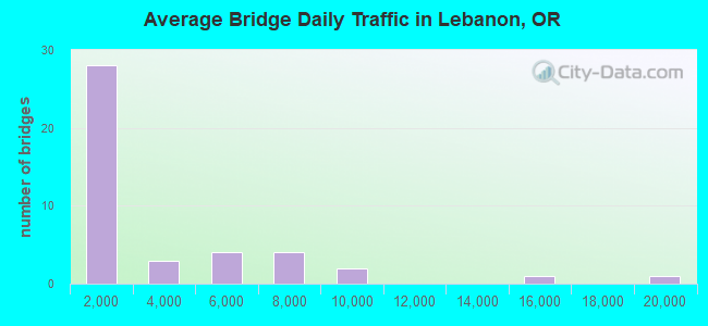
- 124,478Total average daily traffic
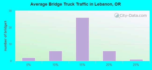
- 13,267Total average daily truck traffic
- 175,693Total future (year 2040) average daily traffic
- National Bridge Inventory (NBI) Registered Bridges for Lebanon
- No street view available for this location
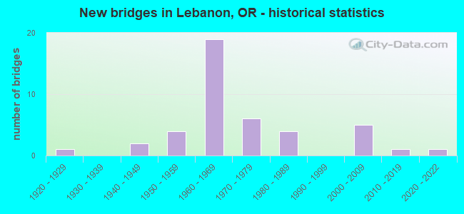
- New bridges - historical statistics
- 11920-1929
- 21940-1949
- 41950-1959
- 191960-1969
- 61970-1979
- 41980-1989
- 52000-2009
- 12010-2019
- 12020-2022

- Reconstructed bridges - Historical Statistics
- 11960-1969
- 01970-1979
- 01980-1989
- 31990-1999
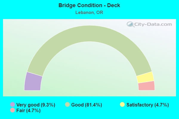
- Bridge Condition - Deck
- 9.3%Very good
- 81.4%Good
- 4.7%Satisfactory
- 4.7%Fair
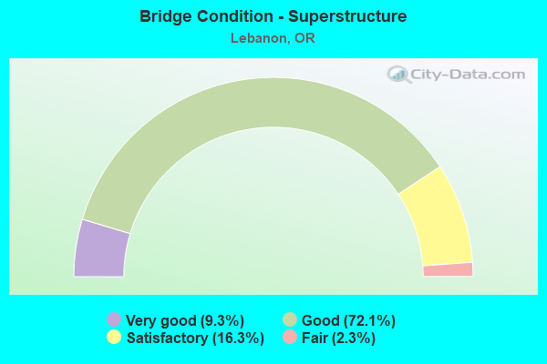
- Bridge Condition - Superstructure
- 9.3%Very good
- 72.1%Good
- 16.3%Satisfactory
- 2.3%Fair
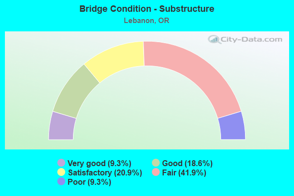
- Bridge Condition - Substructure
- 9.3%Very good
- 18.6%Good
- 20.9%Satisfactory
- 41.9%Fair
- 9.3%Poor
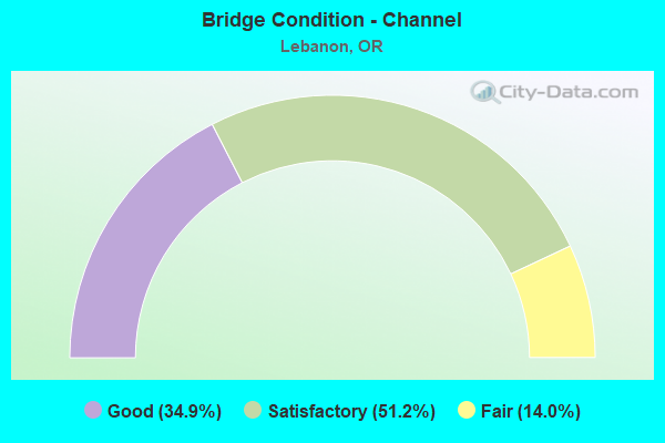
- Bridge Condition - Channel
- 34.9%Good
- 51.2%Satisfactory
- 14.0%Fair
Find on map >> Show street view
Structure Number: 43B008, Location: 1800 S. 2ND STREET (Lat: 44.529142, Lng: -122.909586), Route carried "on" structure: City street , Year Built: 1964, Year Reconstructed: 2002, Status: Open, Structure Length: 1.25m (4.10ft), Average Daily Traffic: 4,944 (year 2021), Truck Traffic: 10%, Average Future Daily Traffic: 7,519 (year 2041), Design Load: HS 20, Features Intersected: SANTIAM-ALBANY CANAL, Facility Carried by Structure: 2ND ST
Minimum Vertical Clearance: 30+ m (98+ ft), Kilometerpoint: 1.690, Lanes on structure: 2, Owner: City or Municipal Highway Agency, Approaching Roadway Width: 13.4m (44.0ft), Skew: 9 degrees, Material/Design: Prestressed concrete, Design/Construction: Slab, Number Of Spans In Main Unit: 1, Length of Maximum Span: 11.9m (39.0ft), Curb or Sidewalk Widths: Left: 1.7m (5.6ft), Right: 1.7m (5.6ft), Curb-To-Curb Width: 13.4m (44.0ft), Out-to-Out Width: 17.4m (57.1ft)
Condition: Deck: Good, Superstructure: Good, Substructure: Fair, Channel: Satisfactory, Operating Rating: 60.8 metric tons, Method Used To Determine Operating Rating: Allowable Stress (AS), Inventory Rating: 32.7 metric tons, Method Used To Determine Inventory Rating: Allowable Stress (AS), Structural Evaluation: Somewhat better than minimum adequacy, Deck Geometry: Better than present minimum criteria, Waterway Adequacy: Equal to present desirable criteria, Approach Roadway Alignment: Equal to present desirable criteria, Designated Inspection Frequency: Every 24 months, Underwater Inspection Frequency: Every 60 months, Inspection Date: July 2021, Underwater Inspection Date: March 2019, Deck Structure Type: Other, Wearing Surface/Protective System: Wearing Surface: Bituminous
Find on map >> Show street view
Structure Number: 43B009, Location: 001 N OF CL WHEELER ST. (Lat: 44.547075, Lng: -122.902167), Route carried "on" structure: City street , Year Built: 1967, Status: Open, Structure Length: 1.55m (5.09ft), Average Daily Traffic: 268 (year 2021), Truck Traffic: 10%, Average Future Daily Traffic: 515 (year 2041), Design Load: HS 20, Features Intersected: ALBANY-SANTIAM CANAL, Facility Carried by Structure: NORTH WILLIAMS ST
Minimum Vertical Clearance: 30+ m (98+ ft), Kilometerpoint: 0.129, Lanes on structure: 2, Owner: City or Municipal Highway Agency, Approaching Roadway Width: 6.7m (22.0ft), Material/Design: Prestressed concrete, Design/Construction: Slab, Number Of Spans In Main Unit: 1, Length of Maximum Span: 15.2m (49.9ft), Curb or Sidewalk Widths: Left: 0.0m, Right: 1.5m (4.9ft), Curb-To-Curb Width: 6.7m (22.0ft), Out-to-Out Width: 8.5m (27.9ft)
Condition: Deck: Good, Superstructure: Good, Substructure: Fair, Channel: Satisfactory, Operating Rating: 64.4 metric tons, Method Used To Determine Operating Rating: Load Factor (LF), Inventory Rating: 33.6 metric tons, Method Used To Determine Inventory Rating: Load Factor (LF), Structural Evaluation: Somewhat better than minimum adequacy, Deck Geometry: Meets minimum limits, Waterway Adequacy: Equal to present desirable criteria, Approach Roadway Alignment: Equal to present minimum criteria, Designated Inspection Frequency: Every 24 months, Inspection Date: July 2021, Deck Structure Type: Other, Wearing Surface/Protective System: Wearing Surface: Bituminous, Membrane: Preformed Fabric
Find on map >> Show street view
Structure Number: 43B01, Location: 850 S. WILLIAMS STREET (Lat: 44.537992, Lng: -122.902578), Route carried "on" structure: City street , Year Built: 1961, Status: Open, Structure Length: 1.80m (5.91ft), Average Daily Traffic: 5,047 (year 2021), Truck Traffic: 15%, Average Future Daily Traffic: 6,736 (year 2041), Design Load: HS 20, Features Intersected: ALBANY-SANTIAM CANAL, Facility Carried by Structure: WILLIAMS STREET
Minimum Vertical Clearance: 30+ m (98+ ft), Kilometerpoint: 0.917, Lanes on structure: 2, Owner: City or Municipal Highway Agency, Approaching Roadway Width: 10.1m (33.1ft), Skew: 3 degrees, Material/Design: Prestressed concrete, Design/Construction: Tee Beam, Number Of Spans In Main Unit: 1, Length of Maximum Span: 17.4m (57.1ft), Curb or Sidewalk Widths: Left: 1.6m (5.2ft), Right: 1.6m (5.2ft), Curb-To-Curb Width: 9.8m (32.2ft), Out-to-Out Width: 13.7m (44.9ft)
Condition: Deck: Good, Superstructure: Good, Substructure: Fair, Channel: Satisfactory, Operating Rating: 22.0 metric tons, Method Used To Determine Operating Rating: Load and Resistance Factor Rating (LRFR) rating reported by rating factor(RF) method using HL-93 loadings, Inventory Rating: 17.2 metric tons, Method Used To Determine Inventory Rating: Load and Resistance Factor Rating (LRFR) rating reported by rating factor(RF) method using HL-93 loadings, Structural Evaluation: Meets minimum limits, Deck Geometry: Meets minimum limits, Waterway Adequacy: Equal to present desirable criteria, Approach Roadway Alignment: Equal to present desirable criteria, Designated Inspection Frequency: Every 24 months, Inspection Date: July 2021, Deck Structure Type: Concrete Cast-file-Place, Wearing Surface/Protective System: Wearing Surface: Bituminous
Find on map >> Show street view
Structure Number: 43B12, Location: 001 MI S HWY22 (Lat: 44.548758, Lng: -122.905711), Route carried "on" structure: City street , Year Built: 1987, Status: Open, Structure Length: 1.55m (5.09ft), Average Daily Traffic: 443 (year 2021), Truck Traffic: 20%, Average Future Daily Traffic: 649 (year 2041), Design Load: HS 20, Features Intersected: SANTIAM-ALBANY CANAL, Facility Carried by Structure: INDUSTRIAL WAY
Minimum Vertical Clearance: 30+ m (98+ ft), Kilometerpoint: 0.161, Lanes on structure: 2, Owner: City or Municipal Highway Agency, Approaching Roadway Width: 8.5m (27.9ft), Material/Design: Prestressed concrete, Design/Construction: Slab, Number Of Spans In Main Unit: 1, Length of Maximum Span: 15.2m (49.9ft), Curb or Sidewalk Widths: Left: 1.7m (5.6ft), Right: 0.0m, Curb-To-Curb Width: 8.5m (27.9ft), Out-to-Out Width: 11.0m (36.1ft)
Condition: Deck: Good, Superstructure: Good, Substructure: Good, Channel: Satisfactory, Operating Rating: 66.2 metric tons, Method Used To Determine Operating Rating: Load Factor (LF), Inventory Rating: 39.9 metric tons, Method Used To Determine Inventory Rating: Load Factor (LF), Structural Evaluation: Better than present minimum criteria, Deck Geometry: Somewhat better than minimum adequacy, Waterway Adequacy: Equal to present desirable criteria, Approach Roadway Alignment: Equal to present desirable criteria, Length Of Structure Improvement: 2.00m (6.56ft), Designated Inspection Frequency: Every 24 months, Inspection Date: July 2021, Bridge Improvement Cost: $212,000, Roadway Improvement Cost: $21,000, Total Project Cost: $340,000, Deck Structure Type: Other, Wearing Surface/Protective System: Wearing Surface: Bituminous