Bridge Statistics for Lincoln, Alabama (AL)
Condition, Traffic, Stress, Structural Evaluation, Project Costs
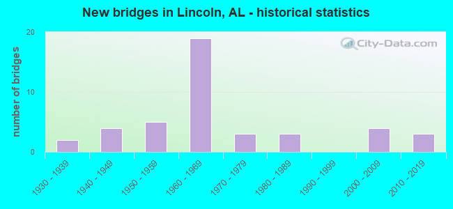
- New bridges - historical statistics
- 21930-1939
- 41940-1949
- 51950-1959
- 191960-1969
- 31970-1979
- 31980-1989
- 42000-2009
- 32010-2019
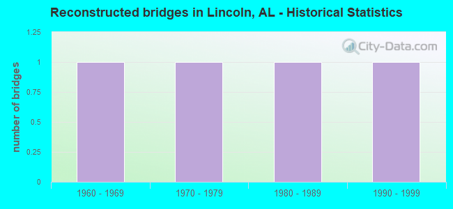
- Reconstructed bridges - Historical Statistics
- 11960-1969
- 11970-1979
- 11980-1989
- 11990-1999
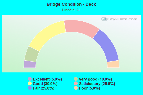
- Bridge Condition - Deck
- 5.0%Excellent
- 10.0%Very good
- 30.0%Good
- 25.0%Satisfactory
- 25.0%Fair
- 5.0%Poor
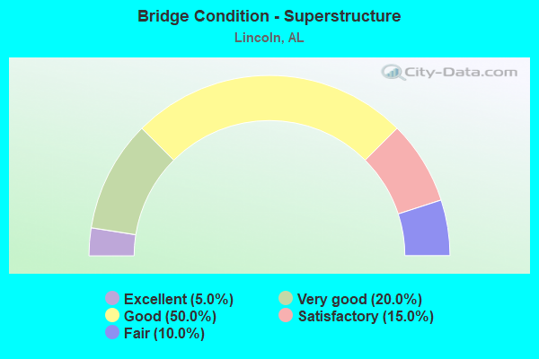
- Bridge Condition - Superstructure
- 5.0%Excellent
- 20.0%Very good
- 50.0%Good
- 15.0%Satisfactory
- 10.0%Fair
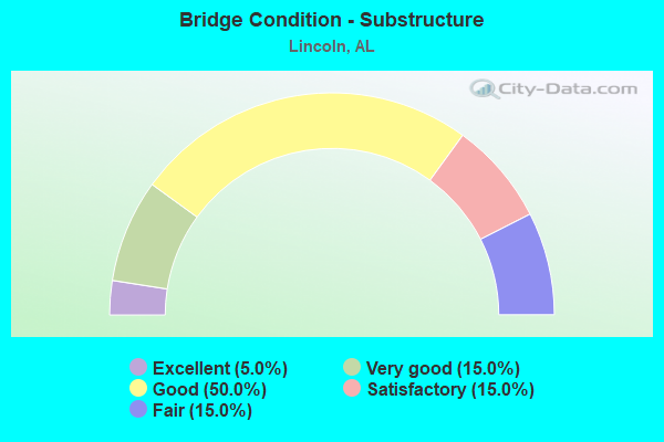
- Bridge Condition - Substructure
- 5.0%Excellent
- 15.0%Very good
- 50.0%Good
- 15.0%Satisfactory
- 15.0%Fair
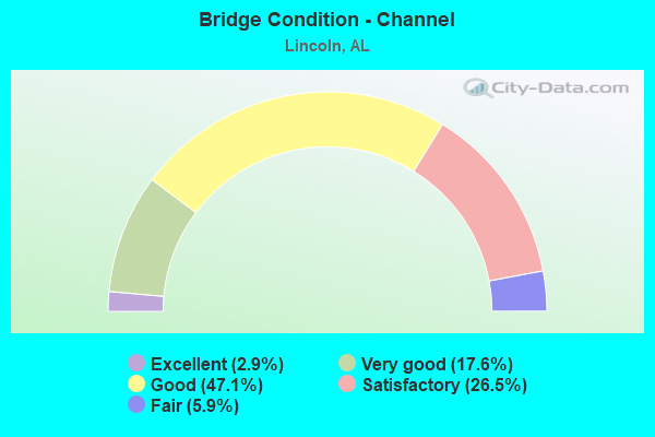
- Bridge Condition - Channel
- 2.9%Excellent
- 17.6%Very good
- 47.1%Good
- 26.5%Satisfactory
- 5.9%Fair

- Bridge Condition - Culverts
- 68.4%Good
- 31.6%Satisfactory
Find on map >> Show street view
Structure Number: 8542, Location: 5.0 MI E JCT SR 77 (Lat: 33.584556, Lng: -86.039361), Route carried "under" structure: Interstate 20, Year Built: 1965, Structure Length: 0. m, Average Daily Traffic: 42,788 (year 2018), Truck Traffic: 38%, Features Intersected: I-20, Facility Carried by Structure: CO 97/AIRPORT RD.
Minimum Vertical Clearance: 5.50m (18.04ft), Kilometerpoint: 278.511, Lanes on structure: 2, Lanes under structure: 4, Material/Design: Concrete continuous, Design/Construction: Tee Beam, Length of Maximum Span: 22.3m (73.2ft)
Find on map >> Show street view
Structure Number: 11549, Location: JCT I-20 AND SR-77 (Lat: 33.589906, Lng: -86.124389), Route carried "under" structure: Interstate 20, Year Built: 1964, Structure Length: 0. m, Average Daily Traffic: 39,910 (year 2013), Truck Traffic: 35%, Features Intersected: I-20, Facility Carried by Structure: SR-77
Minimum Vertical Clearance: 5.46m (17.91ft), Kilometerpoint: 270.581, Lanes on structure: 5, Lanes under structure: 4, Material/Design: Concrete continuous, Design/Construction: Tee Beam, Length of Maximum Span: 22.3m (73.2ft)