Bridge Statistics for Live Oak, Texas (TX)
Condition, Traffic, Stress, Structural Evaluation, Project Costs
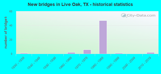
- New bridges - historical statistics
- 11930-1939
- 21960-1969
- 61970-1979
- 471980-1989
- 11990-1999
- 22010-2019
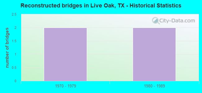
- Reconstructed bridges - Historical Statistics
- 21970-1979
- 21980-1989
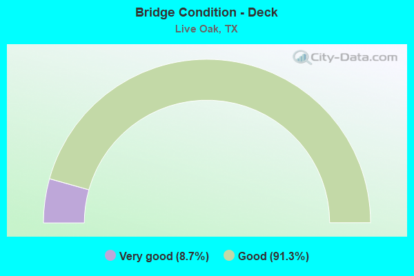
- Bridge Condition - Deck
- 8.7%Very good
- 91.3%Good
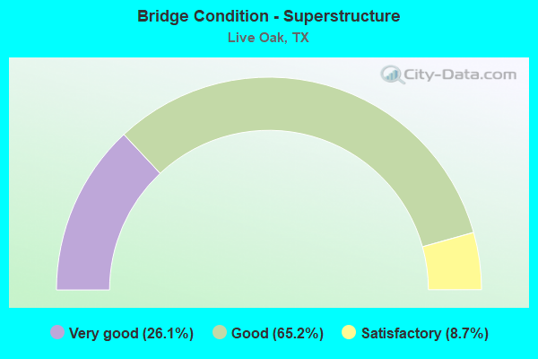
- Bridge Condition - Superstructure
- 26.1%Very good
- 65.2%Good
- 8.7%Satisfactory
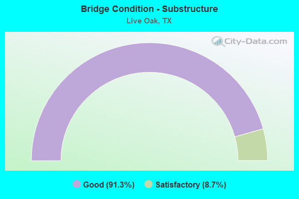
- Bridge Condition - Substructure
- 91.3%Good
- 8.7%Satisfactory
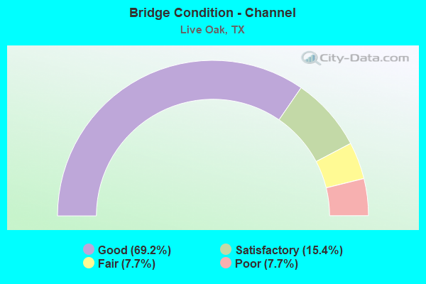
- Bridge Condition - Channel
- 69.2%Good
- 15.4%Satisfactory
- 7.7%Fair
- 7.7%Poor
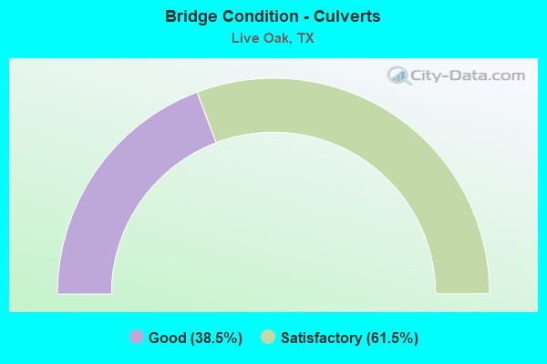
- Bridge Condition - Culverts
- 38.5%Good
- 61.5%Satisfactory
Find on map >> Show street view
Structure Number: 150150001607024, Location: 0.65 MI S OF LOOP 1604 (Lat: 29.560647, Lng: -98.341144), Route carried "on" structure: Interstate 35, Year Built: 1934, Year Reconstructed: 1987, Status: Open, Structure Length: 0.88m (2.89ft), Average Daily Traffic: 112,643 (year 2020), Truck Traffic: 12%, Average Future Daily Traffic: 250,530 (year 2033), Design Load: H 15, Features Intersected: DRAINAGE DITCH
Minimum Vertical Clearance: 30+ m (98+ ft), Kilometerpoint: 60.714, Lanes on structure: 11, Owner: State Highway Agency, Approaching Roadway Width: 51.2m (168.0ft), Skew: 9 degrees, Material/Design: Concrete, Design/Construction: Culvert, Number Of Spans In Main Unit: 5, Length of Maximum Span: 1.5m (4.9ft)
Condition: Channel: Good, Culverts: Satisfactory, Operating Rating: 39.9 metric tons, Method Used To Determine Operating Rating: Load Factor (LF), Inventory Rating: 23.6 metric tons, Method Used To Determine Inventory Rating: Load Factor (LF), Structural Evaluation: Somewhat better than minimum adequacy, Waterway Adequacy: Equal to present minimum criteria, Approach Roadway Alignment: Equal to present desirable criteria, Designated Inspection Frequency: Every 24 months, Inspection Date: May 2020
Find on map >> Show street view
Structure Number: 150150001607157, Location: 0.73 MI SO OF SH 218 (Lat: 29.555803, Lng: -98.346583), Route carried "on" structure: Ramp Interstate 35, Year Built: 1984, Status: Open, Structure Length: 2.50m (8.20ft), Average Daily Traffic: 470 (year 2013), Truck Traffic: 13%, Average Future Daily Traffic: 660 (year 2033), Design Load: HS 20, Features Intersected: IH 35 NB ON RAMP
Minimum Vertical Clearance: 30+ m (98+ ft), Kilometerpoint: 59.943, Lanes on structure: 1, Lanes under structure: 1, Owner: State Highway Agency, Approaching Roadway Width: 7.3m (24.0ft), Skew: 9 degrees, Material/Design: Prestressed concrete, Design/Construction: Stringer/Multi-beam, Number Of Spans In Main Unit: 1, Length of Maximum Span: 25.0m (82.0ft), Curb-To-Curb Width: 7.2m (23.6ft), Out-to-Out Width: 7.9m (25.9ft)
Condition: Deck: Very good, Superstructure: Good, Substructure: Good, Operating Rating: 54.4 metric tons, Method Used To Determine Operating Rating: Assigned rating based on Load Factor Design (LFD) reported in metric tons, Inventory Rating: 32.7 metric tons, Method Used To Determine Inventory Rating: Assigned rating based on Load Factor Design (LFD) reported in metric tons, Structural Evaluation: Better than present minimum criteria, Deck Geometry: Equal to present minimum criteria, Underclear: Meets minimum limits, Approach Roadway Alignment: Better than present minimum criteria, Designated Inspection Frequency: Every 24 months, Inspection Date: May 2020, Deck Structure Type: Concrete Precast Panels, Wearing Surface/Protective System: Wearing Surface: Bituminous
Find on map >> Show street view
Structure Number: 150150001607158, Location: 0.83 MI S OF SH 218 (Lat: 29.555067, Lng: -98.348247), Route carried "on" structure: Interstate 35, Year Built: 1984, Status: Open, Structure Length: 6.40m (21.00ft), Average Daily Traffic: 68,001 (year 2018), Truck Traffic: 12%, Average Future Daily Traffic: 125,260 (year 2033), Design Load: HS 20, Features Intersected: TOEPPERWEIN RD
Minimum Vertical Clearance: 30+ m (98+ ft), Kilometerpoint: 59.723, Lanes on structure: 4, Lanes under structure: 4, Owner: State Highway Agency, Approaching Roadway Width: 20.7m (67.9ft), Material/Design: Prestressed concrete, Design/Construction: Stringer/Multi-beam, Number Of Spans In Main Unit: 3, Length of Maximum Span: 24.4m (80.1ft), Curb-To-Curb Width: 20.8m (68.2ft), Out-to-Out Width: 21.6m (70.9ft)
Condition: Deck: Good, Superstructure: Good, Substructure: Good, Operating Rating: 54.4 metric tons, Method Used To Determine Operating Rating: Assigned rating based on Load Factor Design (LFD) reported in metric tons, Inventory Rating: 32.7 metric tons, Method Used To Determine Inventory Rating: Assigned rating based on Load Factor Design (LFD) reported in metric tons, Structural Evaluation: Better than present minimum criteria, Deck Geometry: Equal to present minimum criteria, Underclear: Better than present minimum criteria, Approach Roadway Alignment: Equal to present desirable criteria, Designated Inspection Frequency: Every 24 months, Inspection Date: May 2020, Deck Structure Type: Concrete Precast Panels, Wearing Surface/Protective System: Wearing Surface: Bituminous
Find on map >> Show street view
Structure Number: 150150001607159, Location: 0.83 MI S OF SH 218 (Lat: 29.555150, Lng: -98.348294), Route carried "on" structure: Interstate 35, Year Built: 1984, Status: Open, Structure Length: 6.40m (21.00ft), Average Daily Traffic: 58,935 (year 2018), Truck Traffic: 12%, Average Future Daily Traffic: 125,260 (year 2033), Design Load: HS 20, Features Intersected: TOEPPERWEIN RD
Minimum Vertical Clearance: 30+ m (98+ ft), Kilometerpoint: 59.723, Lanes on structure: 5, Lanes under structure: 4, Owner: State Highway Agency, Approaching Roadway Width: 20.7m (67.9ft), Material/Design: Prestressed concrete, Design/Construction: Stringer/Multi-beam, Number Of Spans In Main Unit: 3, Length of Maximum Span: 24.4m (80.1ft), Curb-To-Curb Width: 20.8m (68.2ft), Out-to-Out Width: 21.6m (70.9ft)
Condition: Deck: Good, Superstructure: Good, Substructure: Good, Operating Rating: 54.4 metric tons, Method Used To Determine Operating Rating: Assigned rating based on Load Factor Design (LFD) reported in metric tons, Inventory Rating: 32.7 metric tons, Method Used To Determine Inventory Rating: Assigned rating based on Load Factor Design (LFD) reported in metric tons, Structural Evaluation: Better than present minimum criteria, Deck Geometry: Meets minimum limits, Underclear: Equal to present desirable criteria, Approach Roadway Alignment: Equal to present desirable criteria, Designated Inspection Frequency: Every 24 months, Inspection Date: May 2020, Deck Structure Type: Concrete Cast-file-Place, Wearing Surface/Protective System: Wearing Surface: Bituminous
Find on map >> Show street view
Structure Number: 150150001607166, Location: IH 35/LP 1604 INTER (Lat: 29.568122, Lng: -98.332911), Route carried "on" structure: ServiceState highway 1604, Year Built: 1986, Status: Open, Structure Length: 11.28m (37.01ft), Average Daily Traffic: 26,770 (year 2013), Truck Traffic: 6%, Average Future Daily Traffic: 37,480 (year 2033), Design Load: HS 20, Features Intersected: IH 35
Minimum Vertical Clearance: 30+ m (98+ ft), Kilometerpoint: 60.497, Lanes on structure: 2, Lanes under structure: 11, Owner: State Highway Agency, Approaching Roadway Width: 10.7m (35.1ft), Material/Design: Prestressed concrete, Design/Construction: Stringer/Multi-beam, Number Of Spans In Main Unit: 2, Number Of Approach Spans: 4, Length of Maximum Span: 24.4m (80.1ft), Curb-To-Curb Width: 10.7m (35.1ft), Out-to-Out Width: 11.6m (38.1ft)
Condition: Deck: Good, Superstructure: Good, Substructure: Good, Operating Rating: 54.4 metric tons, Method Used To Determine Operating Rating: Assigned rating based on Load Factor Design (LFD) reported in metric tons, Inventory Rating: 32.7 metric tons, Method Used To Determine Inventory Rating: Assigned rating based on Load Factor Design (LFD) reported in metric tons, Structural Evaluation: Better than present minimum criteria, Deck Geometry: Somewhat better than minimum adequacy, Underclear: High priority of corrective action, Approach Roadway Alignment: Equal to present desirable criteria, Designated Inspection Frequency: Every 24 months, Inspection Date: May 2020, Deck Structure Type: Concrete Cast-file-Place
Find on map >> Show street view
Structure Number: 150150001607167, Location: IH 35/LP 1604 INTER (Lat: 29.567969, Lng: -98.333081), Route carried "on" structure: State highway 1604, Year Built: 1986, Status: Open, Structure Length: 11.28m (37.01ft), Average Daily Traffic: 36,180 (year 2013), Truck Traffic: 8%, Average Future Daily Traffic: 50,650 (year 2033), Design Load: HS 20, Features Intersected: IH 35
Minimum Vertical Clearance: 30+ m (98+ ft), Kilometerpoint: 60.497, Lanes on structure: 2, Lanes under structure: 11, Owner: State Highway Agency, Approaching Roadway Width: 13.7m (44.9ft), Material/Design: Prestressed concrete, Design/Construction: Stringer/Multi-beam, Number Of Spans In Main Unit: 2, Number Of Approach Spans: 4, Length of Maximum Span: 24.4m (80.1ft), Curb-To-Curb Width: 13.5m (44.3ft), Out-to-Out Width: 14.3m (46.9ft)
Condition: Deck: Good, Superstructure: Good, Substructure: Good, Operating Rating: 54.4 metric tons, Method Used To Determine Operating Rating: Assigned rating based on Load Factor Design (LFD) reported in metric tons, Inventory Rating: 32.7 metric tons, Method Used To Determine Inventory Rating: Assigned rating based on Load Factor Design (LFD) reported in metric tons, Structural Evaluation: Better than present minimum criteria, Deck Geometry: Superior to present desirable criteria, Underclear: High priority of corrective action, Approach Roadway Alignment: Equal to present desirable criteria, Designated Inspection Frequency: Every 24 months, Inspection Date: May 2020, Deck Structure Type: Concrete Cast-file-Place
Find on map >> Show street view
Structure Number: 150150001607168, Location: IH35/LP 1604 INTER (Lat: 29.567894, Lng: -98.333156), Route carried "on" structure: State highway 1604, Year Built: 1986, Status: Open, Structure Length: 11.28m (37.01ft), Average Daily Traffic: 36,180 (year 2013), Truck Traffic: 8%, Average Future Daily Traffic: 50,650 (year 2033), Design Load: HS 20, Features Intersected: IH 35
Minimum Vertical Clearance: 30+ m (98+ ft), Kilometerpoint: 60.497, Lanes on structure: 2, Lanes under structure: 11, Owner: State Highway Agency, Approaching Roadway Width: 13.7m (44.9ft), Material/Design: Prestressed concrete, Design/Construction: Stringer/Multi-beam, Number Of Spans In Main Unit: 2, Number Of Approach Spans: 4, Length of Maximum Span: 24.4m (80.1ft), Curb-To-Curb Width: 13.6m (44.6ft), Out-to-Out Width: 14.3m (46.9ft)
Condition: Deck: Good, Superstructure: Good, Substructure: Good, Operating Rating: 54.4 metric tons, Method Used To Determine Operating Rating: Assigned ratings based on Allowable Stress Design (ASD) reported in metric tons, Inventory Rating: 32.7 metric tons, Method Used To Determine Inventory Rating: Assigned ratings based on Allowable Stress Design (ASD) reported in metric tons, Structural Evaluation: Better than present minimum criteria, Deck Geometry: Superior to present desirable criteria, Underclear: High priority of corrective action, Approach Roadway Alignment: Equal to present desirable criteria, Designated Inspection Frequency: Every 24 months, Inspection Date: May 2020, Deck Structure Type: Concrete Cast-file-Place
Find on map >> Show street view
Structure Number: 150150001607169, Location: O.10 MI S OF LOOP 1604 (Lat: 29.566889, Lng: -98.334342), Route carried "on" structure: Ramp State highway 1604, Year Built: 1986, Status: Open, Structure Length: 10.18m (33.40ft), Average Daily Traffic: 39,950 (year 2011), Truck Traffic: 4%, Average Future Daily Traffic: 78,100 (year 2031), Design Load: HS 20, Features Intersected: IH 35
Minimum Vertical Clearance: 30+ m (98+ ft), Kilometerpoint: 60.439, Lanes on structure: 1, Lanes under structure: 8, Owner: State Highway Agency, Approaching Roadway Width: 11.0m (36.1ft), Skew: 9 degrees, Material/Design: Prestressed concrete, Design/Construction: Stringer/Multi-beam, Number Of Spans In Main Unit: 2, Number Of Approach Spans: 4, Length of Maximum Span: 22.9m (75.1ft), Curb-To-Curb Width: 10.7m (35.1ft), Out-to-Out Width: 11.6m (38.1ft)
Condition: Deck: Good, Superstructure: Satisfactory, Substructure: Good, Operating Rating: 54.4 metric tons, Method Used To Determine Operating Rating: Assigned rating based on Load Factor Design (LFD) reported in metric tons, Inventory Rating: 32.7 metric tons, Method Used To Determine Inventory Rating: Assigned rating based on Load Factor Design (LFD) reported in metric tons, Structural Evaluation: Equal to present minimum criteria, Deck Geometry: Superior to present desirable criteria, Underclear: High priority of corrective action, Approach Roadway Alignment: Equal to present desirable criteria, Designated Inspection Frequency: Every 24 months, Inspection Date: May 2020, Deck Structure Type: Concrete Cast-file-Place
Find on map >> Show street view
Structure Number: 15015000160717, Location: 0.34 MI S OF LP 1604 (Lat: 29.563436, Lng: -98.337872), Route carried "on" structure: ServiceInterstate 35, Year Built: 1986, Status: Open, Structure Length: 6.10m (20.01ft), Average Daily Traffic: 9,130 (year 2011), Truck Traffic: 16%, Average Future Daily Traffic: 16,420 (year 2031), Design Load: HS 20, Features Intersected: SH 218
Minimum Vertical Clearance: 30+ m (98+ ft), Kilometerpoint: 61.137, Lanes on structure: 3, Lanes under structure: 4, Owner: State Highway Agency, Approaching Roadway Width: 18.9m (62.0ft), Skew: 4 degrees, Material/Design: Prestressed concrete, Design/Construction: Stringer/Multi-beam, Number Of Spans In Main Unit: 1, Number Of Approach Spans: 2, Length of Maximum Span: 27.4m (89.9ft), Curb-To-Curb Width: 19.2m (63.0ft), Out-to-Out Width: 20.0m (65.6ft)
Condition: Deck: Good, Superstructure: Good, Substructure: Good, Operating Rating: 54.4 metric tons, Method Used To Determine Operating Rating: Assigned ratings based on Allowable Stress Design (ASD) reported in metric tons, Inventory Rating: 32.7 metric tons, Method Used To Determine Inventory Rating: Assigned ratings based on Allowable Stress Design (ASD) reported in metric tons, Structural Evaluation: Better than present minimum criteria, Deck Geometry: Superior to present desirable criteria, Underclear: High priority of corrective action, Approach Roadway Alignment: Equal to present desirable criteria, Designated Inspection Frequency: Every 24 months, Inspection Date: May 2020, Deck Structure Type: Concrete Cast-file-Place
Find on map >> Show street view
Structure Number: 150150001607171, Location: 0.50 MI S OF LOOP 1604 (Lat: 29.563450, Lng: -98.338200), Route carried "on" structure: Interstate 35, Year Built: 1986, Status: Open, Structure Length: 6.10m (20.01ft), Average Daily Traffic: 68,001 (year 2018), Truck Traffic: 12%, Average Future Daily Traffic: 125,260 (year 2033), Design Load: HS 20, Features Intersected: SH 218
Minimum Vertical Clearance: 30+ m (98+ ft), Kilometerpoint: 61.087, Lanes on structure: 3, Lanes under structure: 4, Owner: State Highway Agency, Approaching Roadway Width: 17.1m (56.1ft), Skew: 4 degrees, Material/Design: Prestressed concrete, Design/Construction: Stringer/Multi-beam, Number Of Spans In Main Unit: 1, Number Of Approach Spans: 2, Length of Maximum Span: 27.4m (89.9ft), Curb-To-Curb Width: 17.0m (55.8ft), Out-to-Out Width: 17.7m (58.1ft)
Condition: Deck: Good, Superstructure: Good, Substructure: Good, Operating Rating: 54.4 metric tons, Method Used To Determine Operating Rating: Assigned ratings based on Allowable Stress Design (ASD) reported in metric tons, Inventory Rating: 32.7 metric tons, Method Used To Determine Inventory Rating: Assigned ratings based on Allowable Stress Design (ASD) reported in metric tons, Structural Evaluation: Better than present minimum criteria, Deck Geometry: Equal to present minimum criteria, Underclear: High priority of corrective action, Approach Roadway Alignment: Equal to present desirable criteria, Designated Inspection Frequency: Every 24 months, Inspection Date: May 2020, Deck Structure Type: Concrete Cast-file-Place, Wearing Surface/Protective System: Wearing Surface: Bituminous
Find on map >> Show street view
Structure Number: 150150001607172, Location: 0.50 MI S OF LOOP 1604 (Lat: 29.563442, Lng: -98.338333), Route carried "on" structure: Interstate 35, Year Built: 1986, Status: Open, Structure Length: 6.10m (20.01ft), Average Daily Traffic: 58,935 (year 2018), Truck Traffic: 12%, Average Future Daily Traffic: 125,260 (year 2033), Design Load: HS 20, Features Intersected: SH 218
Minimum Vertical Clearance: 30+ m (98+ ft), Kilometerpoint: 61.001, Lanes on structure: 4, Lanes under structure: 4, Owner: State Highway Agency, Approaching Roadway Width: 20.4m (66.9ft), Skew: 4 degrees, Material/Design: Prestressed concrete, Design/Construction: Stringer/Multi-beam, Number Of Spans In Main Unit: 1, Number Of Approach Spans: 2, Length of Maximum Span: 27.4m (89.9ft), Curb-To-Curb Width: 20.4m (66.9ft), Out-to-Out Width: 21.2m (69.6ft)
Condition: Deck: Good, Superstructure: Good, Substructure: Good, Operating Rating: 54.4 metric tons, Method Used To Determine Operating Rating: Assigned rating based on Load Factor Design (LFD) reported in metric tons, Inventory Rating: 32.7 metric tons, Method Used To Determine Inventory Rating: Assigned rating based on Load Factor Design (LFD) reported in metric tons, Structural Evaluation: Better than present minimum criteria, Deck Geometry: Equal to present minimum criteria, Underclear: High priority of corrective action, Approach Roadway Alignment: Equal to present desirable criteria, Designated Inspection Frequency: Every 24 months, Inspection Date: May 2020, Deck Structure Type: Concrete Cast-file-Place, Wearing Surface/Protective System: Wearing Surface: Bituminous
Find on map >> Show street view
Structure Number: 150150001607173, Location: 0.7 MI S OF LP 1604 (Lat: 29.561150, Lng: -98.340928), Route carried "on" structure: City street , Year Built: 1986, Status: Open, Structure Length: 19.32m (63.39ft), Average Daily Traffic: 2,530 (year 2011), Average Future Daily Traffic: 4,000 (year 2031), Design Load: HS 20, Features Intersected: IH 35, Facility Carried by Structure: SHIN OAK DRIVE
Minimum Vertical Clearance: 30+ m (98+ ft), Kilometerpoint: 0.080, Lanes on structure: 2, Lanes under structure: 14, Owner: State Highway Agency, Approaching Roadway Width: 14.6m (47.9ft), Skew: 9 degrees, Material/Design: Prestressed concrete, Design/Construction: Stringer/Multi-beam, Number Of Spans In Main Unit: 6, Number Of Approach Spans: 3, Length of Maximum Span: 24.4m (80.1ft), Curb or Sidewalk Widths: Left: 1.1m (3.6ft), Right: 1.2m (3.9ft), Curb-To-Curb Width: 12.2m (40.0ft), Out-to-Out Width: 15.2m (49.9ft)
Condition: Deck: Good, Superstructure: Good, Substructure: Satisfactory, Operating Rating: 54.4 metric tons, Method Used To Determine Operating Rating: Assigned rating based on Load Factor Design (LFD) reported in metric tons, Inventory Rating: 32.7 metric tons, Method Used To Determine Inventory Rating: Assigned rating based on Load Factor Design (LFD) reported in metric tons, Structural Evaluation: Equal to present minimum criteria, Deck Geometry: Equal to present minimum criteria, Underclear: Meets minimum limits, Approach Roadway Alignment: Equal to present desirable criteria, Designated Inspection Frequency: Every 24 months, Inspection Date: May 2020, Deck Structure Type: Concrete Precast Panels
Find on map >> Show street view
Structure Number: 150150001607178, Location: 0.1 MI SE OF IH 35 NB FR (Lat: 29.561969, Lng: -98.341656), Route carried "on" structure: ServiceInterstate 35, Year Built: 1986, Status: Open, Structure Length: 0.91m (2.99ft), Average Daily Traffic: 4,770 (year 2013), Truck Traffic: 13%, Average Future Daily Traffic: 6,680 (year 2033), Design Load: HS 20, Features Intersected: DRAINAGE DITCH, Facility Carried by Structure: SHIN OAK DR
Minimum Vertical Clearance: 30+ m (98+ ft), Kilometerpoint: 60.713, Lanes on structure: 3, Owner: State Highway Agency, Approaching Roadway Width: 14.0m (45.9ft), Skew: 9 degrees, Material/Design: Concrete, Design/Construction: Culvert, Number Of Spans In Main Unit: 3, Length of Maximum Span: 2.7m (8.9ft)
Condition: Channel: Good, Culverts: Good, Operating Rating: 39.9 metric tons, Method Used To Determine Operating Rating: Load Factor (LF), Inventory Rating: 23.6 metric tons, Method Used To Determine Inventory Rating: Load Factor (LF), Structural Evaluation: Equal to present minimum criteria, Waterway Adequacy: Better than present minimum criteria, Approach Roadway Alignment: Equal to present desirable criteria, Designated Inspection Frequency: Every 48 months, Inspection Date: May 2018
Find on map >> Show street view
Structure Number: 15015000160718, Location: IH 35/LP 1604 INTER (Lat: 29.567742, Lng: -98.333322), Route carried "on" structure: ServiceState highway 1604, Year Built: 1986, Status: Open, Structure Length: 11.28m (37.01ft), Average Daily Traffic: 23,230 (year 2010), Truck Traffic: 3%, Average Future Daily Traffic: 29,780 (year 2030), Design Load: HS 20, Features Intersected: IH 35
Minimum Vertical Clearance: 30+ m (98+ ft), Kilometerpoint: 60.497, Lanes on structure: 1, Lanes under structure: 10, Owner: State Highway Agency, Approaching Roadway Width: 11.0m (36.1ft), Material/Design: Prestressed concrete, Design/Construction: Stringer/Multi-beam, Number Of Spans In Main Unit: 2, Number Of Approach Spans: 4, Length of Maximum Span: 24.4m (80.1ft), Curb-To-Curb Width: 9.1m (29.9ft), Out-to-Out Width: 11.6m (38.1ft)
Condition: Deck: Good, Superstructure: Good, Substructure: Good, Operating Rating: 54.4 metric tons, Method Used To Determine Operating Rating: Assigned rating based on Load Factor Design (LFD) reported in metric tons, Inventory Rating: 32.7 metric tons, Method Used To Determine Inventory Rating: Assigned rating based on Load Factor Design (LFD) reported in metric tons, Structural Evaluation: Better than present minimum criteria, Deck Geometry: Meets minimum limits, Underclear: High priority of corrective action, Approach Roadway Alignment: Equal to present desirable criteria, Designated Inspection Frequency: Every 24 months, Inspection Date: May 2020, Deck Structure Type: Concrete Cast-file-Place
Find on map >> Show street view
Structure Number: 150150001607181, Location: 0.15 MI NW OF IH 35 (Lat: 29.570153, Lng: -98.334569), Route carried "on" structure: Ramp Interstate 35, Year Built: 1987, Status: Open, Structure Length: 2.68m (8.79ft), Average Daily Traffic: 12,100 (year 2013), Truck Traffic: 14%, Average Future Daily Traffic: 16,940 (year 2033), Design Load: HS 20, Features Intersected: RANDOLPH BROOKS PARKWAY
Minimum Vertical Clearance: 30+ m (98+ ft), Kilometerpoint: 61.627, Lanes on structure: 2, Lanes under structure: 4, Owner: State Highway Agency, Approaching Roadway Width: 12.2m (40.0ft), Skew: 9 degrees, Material/Design: Prestressed concrete, Design/Construction: Stringer/Multi-beam, Number Of Spans In Main Unit: 2, Length of Maximum Span: 13.4m (44.0ft), Curb-To-Curb Width: 13.3m (43.6ft), Out-to-Out Width: 19.9m (65.3ft)
Condition: Deck: Good, Superstructure: Very good, Substructure: Good, Operating Rating: 54.4 metric tons, Method Used To Determine Operating Rating: Assigned rating based on Load Factor Design (LFD) reported in metric tons, Inventory Rating: 32.7 metric tons, Method Used To Determine Inventory Rating: Assigned rating based on Load Factor Design (LFD) reported in metric tons, Structural Evaluation: Better than present minimum criteria, Deck Geometry: Superior to present desirable criteria, Underclear: Meets minimum limits, Approach Roadway Alignment: Equal to present desirable criteria, Designated Inspection Frequency: Every 24 months, Inspection Date: May 2020, Deck Structure Type: Concrete Cast-file-Place
Find on map >> Show street view
Structure Number: 150150001607441, Location: 0.1 MI NE OF LP 1604 (Lat: 29.569044, Lng: -98.331414), Route carried "on" structure: Ramp Interstate 35, Year Built: 2014, Status: Open, Structure Length: 15.24m (50.00ft), Average Daily Traffic: 17,500 (year 2014), Truck Traffic: 9%, Average Future Daily Traffic: 28,000 (year 2034), Design Load: HL 93, Features Intersected: IH 35 NB ENTRANCE RAMP
Minimum Vertical Clearance: 30+ m (98+ ft), Kilometerpoint: 0.000, Lanes on structure: 1, Lanes under structure: 1, Owner: State Highway Agency, Approaching Roadway Width: 6.1m (20.0ft), Material/Design: Prestressed concrete, Design/Construction: Stringer/Multi-beam, Number Of Spans In Main Unit: 4, Length of Maximum Span: 38.1m (125.0ft), Curb-To-Curb Width: 7.1m (23.3ft), Out-to-Out Width: 7.9m (25.9ft)
Condition: Deck: Very good, Superstructure: Good, Substructure: Good, Operating Rating: 54.4 metric tons, Method Used To Determine Operating Rating: Assigned rating based on Load Factor Design (LFD) reported in metric tons, Inventory Rating: 32.7 metric tons, Method Used To Determine Inventory Rating: Assigned rating based on Load Factor Design (LFD) reported in metric tons, Structural Evaluation: Better than present minimum criteria, Deck Geometry: Equal to present minimum criteria, Underclear: Somewhat better than minimum adequacy, Approach Roadway Alignment: Equal to present desirable criteria, Designated Inspection Frequency: Every 24 months, Inspection Date: May 2020, Deck Structure Type: Concrete Precast Panels
Find on map >> Show street view
Structure Number: 150150245203023, Location: 0.9 Mi NW of IH 35 (Lat: 29.577497, Lng: -98.342211), Route carried "on" structure: State highway 1604, Year Built: 1967, Year Reconstructed: 1987, Status: Open, Structure Length: 1.04m (3.41ft), Average Daily Traffic: 98,587 (year 2020), Truck Traffic: 7%, Average Future Daily Traffic: 119,840 (year 2033), Design Load: HS 20, Features Intersected: Draw
Minimum Vertical Clearance: 30+ m (98+ ft), Kilometerpoint: 58.971, Lanes on structure: 8, Owner: State Highway Agency, Approaching Roadway Width: 41.5m (136.2ft), Skew: 21 degrees, Material/Design: Concrete, Design/Construction: Culvert, Number Of Spans In Main Unit: 5, Length of Maximum Span: 1.8m (5.9ft)
Condition: Channel: Poor, Culverts: Satisfactory, Operating Rating: 39.9 metric tons, Method Used To Determine Operating Rating: Load Factor (LF), Inventory Rating: 23.6 metric tons, Method Used To Determine Inventory Rating: Load Factor (LF), Structural Evaluation: Somewhat better than minimum adequacy, Waterway Adequacy: Superior to present desirable criteria, Approach Roadway Alignment: Equal to present desirable criteria, Designated Inspection Frequency: Every 24 months, Inspection Date: May 2020
Find on map >> Show street view
Structure Number: 150150245203065, Location: 0.2 Mi NW of IH 35 (Lat: 29.569819, Lng: -98.335036), Route carried "on" structure: State highway 1604, Year Built: 1987, Status: Open, Structure Length: 2.62m (8.60ft), Average Daily Traffic: 56,055 (year 2017), Truck Traffic: 7%, Average Future Daily Traffic: 59,920 (year 2033), Design Load: HS 20, Features Intersected: Point NE Pkwy
Minimum Vertical Clearance: 30+ m (98+ ft), Kilometerpoint: 60.198, Lanes on structure: 2, Lanes under structure: 4, Owner: State Highway Agency, Approaching Roadway Width: 13.7m (44.9ft), Skew: 20 degrees, Material/Design: Prestressed concrete, Design/Construction: Stringer/Multi-beam, Number Of Spans In Main Unit: 2, Length of Maximum Span: 13.1m (43.0ft), Curb-To-Curb Width: 13.5m (44.3ft), Out-to-Out Width: 14.3m (46.9ft)
Condition: Deck: Good, Superstructure: Very good, Substructure: Good, Operating Rating: 54.4 metric tons, Method Used To Determine Operating Rating: Assigned rating based on Load Factor Design (LFD) reported in metric tons, Inventory Rating: 32.7 metric tons, Method Used To Determine Inventory Rating: Assigned rating based on Load Factor Design (LFD) reported in metric tons, Structural Evaluation: Better than present minimum criteria, Deck Geometry: Superior to present desirable criteria, Underclear: Meets minimum limits, Approach Roadway Alignment: Equal to present desirable criteria, Designated Inspection Frequency: Every 24 months, Inspection Date: May 2020, Deck Structure Type: Concrete Precast Panels
Find on map >> Show street view
Structure Number: 150150245203066, Location: 0.2 Mi NW of IH 35 (Lat: 29.569625, Lng: -98.335314), Route carried "on" structure: Ramp State highway 1604, Year Built: 1987, Status: Open, Structure Length: 2.62m (8.60ft), Average Daily Traffic: 8,560 (year 2013), Truck Traffic: 7%, Average Future Daily Traffic: 11,980 (year 2033), Design Load: HS 20, Features Intersected: Point NE Pkwy
Minimum Vertical Clearance: 30+ m (98+ ft), Kilometerpoint: 60.165, Lanes on structure: 2, Lanes under structure: 4, Owner: State Highway Agency, Approaching Roadway Width: 11.0m (36.1ft), Material/Design: Prestressed concrete, Design/Construction: Stringer/Multi-beam, Number Of Spans In Main Unit: 2, Length of Maximum Span: 13.1m (43.0ft), Curb-To-Curb Width: 11.8m (38.7ft), Out-to-Out Width: 12.8m (42.0ft)
Condition: Deck: Good, Superstructure: Very good, Substructure: Good, Operating Rating: 54.4 metric tons, Method Used To Determine Operating Rating: Assigned rating based on Load Factor Design (LFD) reported in metric tons, Inventory Rating: 32.7 metric tons, Method Used To Determine Inventory Rating: Assigned rating based on Load Factor Design (LFD) reported in metric tons, Structural Evaluation: Better than present minimum criteria, Deck Geometry: Superior to present desirable criteria, Underclear: Meets minimum limits, Approach Roadway Alignment: Equal to present minimum criteria, Designated Inspection Frequency: Every 24 months, Inspection Date: May 2020, Deck Structure Type: Concrete Precast Panels
Find on map >> Show street view
Structure Number: 150150245203067, Location: 0.1 Mi SE of IH 35 (Lat: 29.566808, Lng: -98.331725), Route carried "on" structure: Ramp State highway 1604, Year Built: 1987, Status: Open, Structure Length: 1.74m (5.71ft), Average Daily Traffic: 7,230 (year 2013), Truck Traffic: 8%, Average Future Daily Traffic: 10,130 (year 2033), Design Load: HS 20, Features Intersected: LP 1604 LP A
Minimum Vertical Clearance: 30+ m (98+ ft), Kilometerpoint: 60.672, Lanes on structure: 1, Lanes under structure: 1, Owner: State Highway Agency, Approaching Roadway Width: 7.9m (25.9ft), Skew: 1 degrees, Material/Design: Prestressed concrete, Design/Construction: Stringer/Multi-beam, Number Of Spans In Main Unit: 1, Length of Maximum Span: 17.4m (57.1ft), Curb-To-Curb Width: 7.7m (25.3ft), Out-to-Out Width: 8.5m (27.9ft)
Condition: Deck: Good, Superstructure: Very good, Substructure: Good, Operating Rating: 54.4 metric tons, Method Used To Determine Operating Rating: Assigned rating based on Load Factor Design (LFD) reported in metric tons, Inventory Rating: 32.7 metric tons, Method Used To Determine Inventory Rating: Assigned rating based on Load Factor Design (LFD) reported in metric tons, Structural Evaluation: Better than present minimum criteria, Deck Geometry: Better than present minimum criteria, Underclear: Superior to present desirable criteria, Approach Roadway Alignment: Equal to present desirable criteria, Designated Inspection Frequency: Every 24 months, Inspection Date: May 2020, Deck Structure Type: Concrete Precast Panels
Find on map >> Show street view
Structure Number: 150150245203068, Location: 0.1 Mi SE of IH 35 (Lat: 29.566711, Lng: -98.332122), Route carried "on" structure: State highway 1604, Year Built: 1987, Status: Open, Structure Length: 1.74m (5.71ft), Average Daily Traffic: 22,002 (year 2017), Truck Traffic: 8%, Average Future Daily Traffic: 50,650 (year 2033), Design Load: HS 20, Features Intersected: LP 1604 LP A
Minimum Vertical Clearance: 30+ m (98+ ft), Kilometerpoint: 60.671, Lanes on structure: 2, Lanes under structure: 1, Owner: State Highway Agency, Approaching Roadway Width: 13.7m (44.9ft), Skew: 20 degrees, Material/Design: Prestressed concrete, Design/Construction: Stringer/Multi-beam, Number Of Spans In Main Unit: 1, Length of Maximum Span: 17.4m (57.1ft), Curb-To-Curb Width: 13.6m (44.6ft), Out-to-Out Width: 14.3m (46.9ft)
Condition: Deck: Good, Superstructure: Good, Substructure: Good, Operating Rating: 54.4 metric tons, Method Used To Determine Operating Rating: Assigned rating based on Load Factor Design (LFD) reported in metric tons, Inventory Rating: 32.7 metric tons, Method Used To Determine Inventory Rating: Assigned rating based on Load Factor Design (LFD) reported in metric tons, Structural Evaluation: Better than present minimum criteria, Deck Geometry: Superior to present desirable criteria, Underclear: Superior to present desirable criteria, Approach Roadway Alignment: Equal to present desirable criteria, Designated Inspection Frequency: Every 24 months, Inspection Date: May 2020, Deck Structure Type: Concrete Precast Panels
Find on map >> Show street view
Structure Number: 150150245203069, Location: 0.1 Mi SE of IH 35 (Lat: 29.566656, Lng: -98.332239), Route carried "on" structure: Ramp State highway 1604, Year Built: 1987, Status: Open, Structure Length: 1.74m (5.71ft), Average Daily Traffic: 7,230 (year 2013), Truck Traffic: 8%, Average Future Daily Traffic: 10,130 (year 2033), Design Load: HS 20, Features Intersected: LP 1604 LP A
Minimum Vertical Clearance: 30+ m (98+ ft), Kilometerpoint: 60.672, Lanes on structure: 1, Lanes under structure: 1, Owner: State Highway Agency, Approaching Roadway Width: 7.9m (25.9ft), Material/Design: Prestressed concrete, Design/Construction: Stringer/Multi-beam, Number Of Spans In Main Unit: 1, Length of Maximum Span: 17.4m (57.1ft), Curb-To-Curb Width: 7.7m (25.3ft), Out-to-Out Width: 8.5m (27.9ft)
Condition: Deck: Good, Superstructure: Very good, Substructure: Good, Operating Rating: 54.4 metric tons, Method Used To Determine Operating Rating: Assigned rating based on Load Factor Design (LFD) reported in metric tons, Inventory Rating: 32.7 metric tons, Method Used To Determine Inventory Rating: Assigned rating based on Load Factor Design (LFD) reported in metric tons, Structural Evaluation: Better than present minimum criteria, Deck Geometry: Better than present minimum criteria, Underclear: Superior to present desirable criteria, Approach Roadway Alignment: Equal to present desirable criteria, Designated Inspection Frequency: Every 24 months, Inspection Date: May 2020, Deck Structure Type: Concrete Precast Panels
Find on map >> Show street view
Structure Number: 150150245203071, Location: 0.2 Mi NW of IH 35 (Lat: 29.569761, Lng: -98.335125), Route carried "on" structure: State highway 1604, Year Built: 1987, Status: Open, Structure Length: 2.62m (8.60ft), Average Daily Traffic: 57,656 (year 2017), Truck Traffic: 7%, Average Future Daily Traffic: 59,920 (year 2033), Design Load: HS 20, Features Intersected: Point NE Pkwy
Minimum Vertical Clearance: 30+ m (98+ ft), Kilometerpoint: 60.198, Lanes on structure: 2, Lanes under structure: 4, Owner: State Highway Agency, Approaching Roadway Width: 13.7m (44.9ft), Skew: 20 degrees, Material/Design: Prestressed concrete, Design/Construction: Stringer/Multi-beam, Number Of Spans In Main Unit: 2, Length of Maximum Span: 13.1m (43.0ft), Curb-To-Curb Width: 13.5m (44.3ft), Out-to-Out Width: 14.3m (46.9ft)
Condition: Deck: Good, Superstructure: Satisfactory, Substructure: Good, Operating Rating: 54.4 metric tons, Method Used To Determine Operating Rating: Assigned rating based on Load Factor Design (LFD) reported in metric tons, Inventory Rating: 32.7 metric tons, Method Used To Determine Inventory Rating: Assigned rating based on Load Factor Design (LFD) reported in metric tons, Structural Evaluation: Equal to present minimum criteria, Deck Geometry: Superior to present desirable criteria, Underclear: Meets minimum limits, Approach Roadway Alignment: Equal to present desirable criteria, Designated Inspection Frequency: Every 24 months, Inspection Date: May 2020, Deck Structure Type: Concrete Precast Panels
Find on map >> Show street view
Structure Number: 150150245203072, Location: 0.1 Mi SE of IH 35 (Lat: 29.566744, Lng: -98.331844), Route carried "on" structure: State highway 1604, Year Built: 1987, Status: Open, Structure Length: 1.74m (5.71ft), Average Daily Traffic: 20,697 (year 2017), Truck Traffic: 8%, Average Future Daily Traffic: 50,650 (year 2033), Design Load: HS 20, Features Intersected: LP 1604 LP A
Minimum Vertical Clearance: 30+ m (98+ ft), Kilometerpoint: 60.658, Lanes on structure: 2, Lanes under structure: 1, Owner: State Highway Agency, Approaching Roadway Width: 13.7m (44.9ft), Skew: 20 degrees, Material/Design: Prestressed concrete, Design/Construction: Stringer/Multi-beam, Number Of Spans In Main Unit: 1, Length of Maximum Span: 17.4m (57.1ft), Curb-To-Curb Width: 13.5m (44.3ft), Out-to-Out Width: 14.3m (46.9ft)
Condition: Deck: Good, Superstructure: Very good, Substructure: Good, Operating Rating: 54.4 metric tons, Method Used To Determine Operating Rating: Assigned rating based on Load Factor Design (LFD) reported in metric tons, Inventory Rating: 32.7 metric tons, Method Used To Determine Inventory Rating: Assigned rating based on Load Factor Design (LFD) reported in metric tons, Structural Evaluation: Better than present minimum criteria, Deck Geometry: Superior to present desirable criteria, Underclear: Superior to present desirable criteria, Approach Roadway Alignment: Equal to present desirable criteria, Designated Inspection Frequency: Every 24 months, Inspection Date: May 2020, Deck Structure Type: Concrete Precast Panels
Find on map >> Show street view
Structure Number: 15015024520321, Location: 0.9 Mi NW of IH 35 (Lat: 29.578261, Lng: -98.342408), Route carried "on" structure: State highway 1604, Year Built: 1988, Status: Open, Structure Length: 8.08m (26.51ft), Average Daily Traffic: 56,055 (year 2017), Truck Traffic: 7%, Average Future Daily Traffic: 42,890 (year 2033), Design Load: HS 20, Features Intersected: Lookout Rd
Minimum Vertical Clearance: 30+ m (98+ ft), Kilometerpoint: 58.950, Lanes on structure: 2, Lanes under structure: 4, Owner: State Highway Agency, Approaching Roadway Width: 11.6m (38.1ft), Material/Design: Prestressed concrete, Design/Construction: Stringer/Multi-beam, Number Of Spans In Main Unit: 3, Length of Maximum Span: 30.5m (100.1ft), Curb-To-Curb Width: 11.3m (37.1ft), Out-to-Out Width: 12.2m (40.0ft)
Condition: Deck: Good, Superstructure: Good, Substructure: Satisfactory, Operating Rating: 54.4 metric tons, Method Used To Determine Operating Rating: Assigned rating based on Load Factor Design (LFD) reported in metric tons, Inventory Rating: 32.7 metric tons, Method Used To Determine Inventory Rating: Assigned rating based on Load Factor Design (LFD) reported in metric tons, Structural Evaluation: Equal to present minimum criteria, Deck Geometry: Somewhat better than minimum adequacy, Underclear: Better than present minimum criteria, Approach Roadway Alignment: Equal to present desirable criteria, Designated Inspection Frequency: Every 24 months, Inspection Date: May 2020, Deck Structure Type: Concrete Precast Panels
Find on map >> Show street view
Structure Number: 150150245203212, Location: 0.70 Mi NW of IH 35 (Lat: 29.576653, Lng: -98.341764), Route carried "on" structure: Ramp State highway 1604, Year Built: 1988, Status: Open, Structure Length: 7.32m (24.02ft), Average Daily Traffic: 3,616 (year 2019), Truck Traffic: 7%, Average Future Daily Traffic: 8,570 (year 2033), Design Load: HS 20, Features Intersected: On Ramp R
Minimum Vertical Clearance: 30+ m (98+ ft), Kilometerpoint: 58.968, Lanes on structure: 1, Lanes under structure: 1, Owner: State Highway Agency, Approaching Roadway Width: 7.0m (23.0ft), Skew: 9 degrees, Material/Design: Prestressed concrete, Design/Construction: Stringer/Multi-beam, Number Of Spans In Main Unit: 2, Length of Maximum Span: 36.6m (120.1ft), Curb-To-Curb Width: 7.1m (23.3ft), Out-to-Out Width: 7.9m (25.9ft)
Condition: Deck: Good, Superstructure: Good, Substructure: Good, Operating Rating: 54.4 metric tons, Method Used To Determine Operating Rating: Assigned rating based on Load Factor Design (LFD) reported in metric tons, Inventory Rating: 32.7 metric tons, Method Used To Determine Inventory Rating: Assigned rating based on Load Factor Design (LFD) reported in metric tons, Structural Evaluation: Better than present minimum criteria, Deck Geometry: Equal to present minimum criteria, Underclear: Meets minimum limits, Approach Roadway Alignment: Equal to present desirable criteria, Designated Inspection Frequency: Every 24 months, Inspection Date: May 2020, Deck Structure Type: Concrete Precast Panels
Find on map >> Show street view
Structure Number: 150150B20860003, Location: 2.1 MI SW OF COUNTY LINE (Lat: 29.579342, Lng: -98.340944), Route carried "on" structure: City street , Year Built: 1998, Status: Open, Structure Length: 0.79m (2.59ft), Average Daily Traffic: 3,230 (year 2011), Average Future Daily Traffic: 1,500 (year 2031), Features Intersected: DRAW, Facility Carried by Structure: LOOKOUT RD
Minimum Vertical Clearance: 30+ m (98+ ft), Kilometerpoint: 3.380, Lanes on structure: 5, Owner: City or Municipal Highway Agency, Approaching Roadway Width: 18.9m (62.0ft), Material/Design: Concrete, Design/Construction: Culvert, Number Of Spans In Main Unit: 3, Length of Maximum Span: 2.1m (6.9ft), Curb-To-Curb Width: 22.3m (73.2ft), Out-to-Out Width: 23.0m (75.5ft)
Condition: Channel: Good, Culverts: Good, Operating Rating: 32.7 metric tons, Method Used To Determine Operating Rating: Field evaluation and documented engineering judgment, Inventory Rating: 24.5 metric tons, Method Used To Determine Inventory Rating: Field evaluation and documented engineering judgment, Structural Evaluation: Equal to present minimum criteria, Deck Geometry: Equal to present minimum criteria, Waterway Adequacy: Equal to present minimum criteria, Approach Roadway Alignment: Equal to present desirable criteria, Designated Inspection Frequency: Every 24 months, Inspection Date: July 2021, Wearing Surface/Protective System: Wearing Surface: Bituminous
Find on map >> Show street view
Structure Number: 150150G00005001, Location: 0.02 MI S OF VILLAGE OAK (Lat: 29.552333, Lng: -98.343608), Route carried "on" structure: City street , Year Built: 1966, Year Reconstructed: 1976, Status: Open, Structure Length: 1.01m (3.31ft), Average Daily Traffic: 523 (year 2020), Average Future Daily Traffic: 750 (year 2033), Features Intersected: DRAW, Facility Carried by Structure: WILDERNESS TR
Minimum Vertical Clearance: 30+ m (98+ ft), Kilometerpoint: 0.483, Lanes on structure: 2, Owner: City or Municipal Highway Agency, Approaching Roadway Width: 9.1m (29.9ft), Material/Design: Concrete, Design/Construction: Culvert, Number Of Spans In Main Unit: 4, Length of Maximum Span: 2.4m (7.9ft), Curb-To-Curb Width: 9.2m (30.2ft), Out-to-Out Width: 9.5m (31.2ft)
Condition: Channel: Good, Culverts: Satisfactory, Operating Rating: 32.7 metric tons, Method Used To Determine Operating Rating: Field evaluation and documented engineering judgment, Inventory Rating: 24.5 metric tons, Method Used To Determine Inventory Rating: Field evaluation and documented engineering judgment, Structural Evaluation: Equal to present minimum criteria, Deck Geometry: Equal to present minimum criteria, Waterway Adequacy: Better than present minimum criteria, Approach Roadway Alignment: Equal to present desirable criteria, Length Of Structure Improvement: 1.04m (3.41ft), Designated Inspection Frequency: Every 24 months, Inspection Date: May 2021, Bridge Improvement Cost: $62,000, Roadway Improvement Cost: $6,000, Total Project Cost: $93,000, Deck Structure Type: Concrete Cast-file-Place
Find on map >> Show street view
Structure Number: 150150G00020001, Location: 0.03 MI E OF OLD SPANISH (Lat: 29.553281, Lng: -98.332700), Route carried "on" structure: City street , Year Built: 1972, Status: Open, Structure Length: 0.79m (2.59ft), Average Daily Traffic: 2,020 (year 2020), Average Future Daily Traffic: 4,500 (year 2033), Features Intersected: DRAW, Facility Carried by Structure: SHIN OAK DR
Minimum Vertical Clearance: 30+ m (98+ ft), Kilometerpoint: 1.127, Lanes on structure: 2, Owner: City or Municipal Highway Agency, Approaching Roadway Width: 12.5m (41.0ft), Material/Design: Concrete, Design/Construction: Culvert, Number Of Spans In Main Unit: 3, Length of Maximum Span: 2.4m (7.9ft), Curb or Sidewalk Widths: Left: 1.5m (4.9ft), Right: 0.0m, Curb-To-Curb Width: 12.5m (41.0ft), Out-to-Out Width: 14.5m (47.6ft)
Condition: Channel: Good, Culverts: Satisfactory, Operating Rating: 32.7 metric tons, Method Used To Determine Operating Rating: Field evaluation and documented engineering judgment, Inventory Rating: 24.5 metric tons, Method Used To Determine Inventory Rating: Field evaluation and documented engineering judgment, Structural Evaluation: Equal to present minimum criteria, Deck Geometry: Equal to present minimum criteria, Waterway Adequacy: Better than present minimum criteria, Approach Roadway Alignment: Equal to present desirable criteria, Length Of Structure Improvement: 0.82m (2.69ft), Designated Inspection Frequency: Every 24 months, Inspection Date: May 2021, Bridge Improvement Cost: $22,000, Roadway Improvement Cost: $6,000, Total Project Cost: $28,000, Deck Structure Type: Concrete Cast-file-Place
Find on map >> Show street view
Structure Number: 150150G00025001, Location: 0.15 MI S OF VILLAGE OAK (Lat: 29.554089, Lng: -98.335917), Route carried "on" structure: City street , Year Built: 1975, Status: Open, Structure Length: 1.22m (4.00ft), Average Daily Traffic: 940 (year 2013), Average Future Daily Traffic: 1,200 (year 2033), Features Intersected: DRAW, Facility Carried by Structure: WELCOME DR
Minimum Vertical Clearance: 30+ m (98+ ft), Kilometerpoint: 0.917, Lanes on structure: 2, Owner: City or Municipal Highway Agency, Approaching Roadway Width: 9.1m (29.9ft), Skew: 1 degrees, Material/Design: Concrete, Design/Construction: Culvert, Number Of Spans In Main Unit: 4, Length of Maximum Span: 2.7m (8.9ft), Curb or Sidewalk Widths: Left: 0.0m, Right: 1.1m (3.6ft), Curb-To-Curb Width: 9.0m (29.5ft), Out-to-Out Width: 10.5m (34.4ft)
Condition: Channel: Good, Culverts: Good, Operating Rating: 32.7 metric tons, Method Used To Determine Operating Rating: Field evaluation and documented engineering judgment, Inventory Rating: 24.5 metric tons, Method Used To Determine Inventory Rating: Field evaluation and documented engineering judgment, Structural Evaluation: Equal to present minimum criteria, Deck Geometry: Somewhat better than minimum adequacy, Waterway Adequacy: Better than present minimum criteria, Approach Roadway Alignment: Equal to present desirable criteria, Designated Inspection Frequency: Every 24 months, Inspection Date: May 2021, Deck Structure Type: Concrete Cast-file-Place
Find on map >> Show street view
Structure Number: 150150G00050001, Location: 0.65 MI E OF TOEPPERWEIN (Lat: 29.556408, Lng: -98.336611), Route carried "on" structure: City street , Year Built: 1972, Status: Open, Structure Length: 1.04m (3.41ft), Average Daily Traffic: 6,390 (year 2013), Average Future Daily Traffic: 7,500 (year 2033), Features Intersected: SALITRILLO CREEK, Facility Carried by Structure: VILLAGE OAK DR
Minimum Vertical Clearance: 30+ m (98+ ft), Kilometerpoint: 1.046, Lanes on structure: 2, Owner: City or Municipal Highway Agency, Approaching Roadway Width: 12.8m (42.0ft), Material/Design: Concrete, Design/Construction: Culvert, Number Of Spans In Main Unit: 4, Length of Maximum Span: 2.4m (7.9ft), Curb or Sidewalk Widths: Left: 1.4m (4.6ft), Right: 0.0m, Curb-To-Curb Width: 12.8m (42.0ft), Out-to-Out Width: 14.5m (47.6ft)
Condition: Channel: Good, Culverts: Satisfactory, Operating Rating: 32.7 metric tons, Method Used To Determine Operating Rating: Field evaluation and documented engineering judgment, Inventory Rating: 24.5 metric tons, Method Used To Determine Inventory Rating: Field evaluation and documented engineering judgment, Structural Evaluation: Equal to present minimum criteria, Deck Geometry: Somewhat better than minimum adequacy, Waterway Adequacy: Better than present minimum criteria, Approach Roadway Alignment: Equal to present desirable criteria, Length Of Structure Improvement: 1.07m (3.51ft), Designated Inspection Frequency: Every 24 months, Inspection Date: May 2021, Bridge Improvement Cost: $30,000, Roadway Improvement Cost: $8,000, Total Project Cost: $38,000, Deck Structure Type: Concrete Cast-file-Place
Find on map >> Show street view
Structure Number: 150150G00065001, Location: 0.05 MI S OF VILLAGE OAK (Lat: 29.552953, Lng: -98.340950), Route carried "on" structure: City street , Year Built: 1970, Year Reconstructed: 1977, Status: Open, Structure Length: 1.10m (3.61ft), Average Daily Traffic: 244 (year 2020), Average Future Daily Traffic: 350 (year 2033), Features Intersected: DRAW, Facility Carried by Structure: NORTHLEDGE DR
Minimum Vertical Clearance: 30+ m (98+ ft), Kilometerpoint: 0.483, Lanes on structure: 2, Owner: City or Municipal Highway Agency, Approaching Roadway Width: 9.1m (29.9ft), Material/Design: Concrete, Design/Construction: Culvert, Number Of Spans In Main Unit: 4, Length of Maximum Span: 2.4m (7.9ft), Curb-To-Curb Width: 9.2m (30.2ft), Out-to-Out Width: 9.6m (31.5ft)
Condition: Channel: Good, Culverts: Good, Operating Rating: 32.7 metric tons, Method Used To Determine Operating Rating: Field evaluation and documented engineering judgment, Inventory Rating: 24.5 metric tons, Method Used To Determine Inventory Rating: Field evaluation and documented engineering judgment, Structural Evaluation: Equal to present minimum criteria, Deck Geometry: Equal to present minimum criteria, Waterway Adequacy: Better than present minimum criteria, Approach Roadway Alignment: Equal to present desirable criteria, Designated Inspection Frequency: Every 24 months, Inspection Date: May 2021, Deck Structure Type: Concrete Cast-file-Place
Find on map >> Show street view
Structure Number: 150150G00080001, Location: 0.15 MI S OF VILLAGE OAK (Lat: 29.553197, Lng: -98.337903), Route carried "on" structure: City street , Year Built: 1973, Status: Open, Structure Length: 1.19m (3.90ft), Average Daily Traffic: 428 (year 2020), Average Future Daily Traffic: 950 (year 2033), Features Intersected: DRAW, Facility Carried by Structure: LONE SHADOW TR
Minimum Vertical Clearance: 30+ m (98+ ft), Kilometerpoint: 0.982, Lanes on structure: 2, Owner: City or Municipal Highway Agency, Approaching Roadway Width: 9.1m (29.9ft), Material/Design: Concrete, Design/Construction: Culvert, Number Of Spans In Main Unit: 4, Length of Maximum Span: 2.7m (8.9ft), Curb or Sidewalk Widths: Left: 1.3m (4.3ft), Right: 0.0m, Curb-To-Curb Width: 9.2m (30.2ft), Out-to-Out Width: 10.9m (35.8ft)
Condition: Channel: Satisfactory, Culverts: Satisfactory, Operating Rating: 32.7 metric tons, Method Used To Determine Operating Rating: Field evaluation and documented engineering judgment, Inventory Rating: 24.5 metric tons, Method Used To Determine Inventory Rating: Field evaluation and documented engineering judgment, Structural Evaluation: Equal to present minimum criteria, Deck Geometry: Equal to present minimum criteria, Waterway Adequacy: Better than present minimum criteria, Approach Roadway Alignment: Equal to present desirable criteria, Designated Inspection Frequency: Every 24 months, Inspection Date: May 2021, Deck Structure Type: Concrete Cast-file-Place
Find on map >> Show street view
Structure Number: 150150G00085001, Location: 0.03 MI SW OF SHIN OAK (Lat: 29.559814, Lng: -98.339122), Route carried "on" structure: City street , Year Built: 1984, Status: Open, Structure Length: 0.91m (2.99ft), Average Daily Traffic: 523 (year 2020), Average Future Daily Traffic: 750 (year 2033), Design Load: HS 20, Features Intersected: SALITRILLO CREEK, Facility Carried by Structure: GREYCLIFF DR
Minimum Vertical Clearance: 30+ m (98+ ft), Kilometerpoint: 0.080, Lanes on structure: 2, Owner: City or Municipal Highway Agency, Approaching Roadway Width: 9.1m (29.9ft), Skew: 1 degrees, Material/Design: Concrete, Design/Construction: Culvert, Number Of Spans In Main Unit: 3, Length of Maximum Span: 2.7m (8.9ft), Curb-To-Curb Width: 9.2m (30.2ft), Out-to-Out Width: 9.6m (31.5ft)
Condition: Channel: Good, Culverts: Good, Operating Rating: 39.9 metric tons, Method Used To Determine Operating Rating: Load Factor (LF), Inventory Rating: 23.6 metric tons, Method Used To Determine Inventory Rating: Load Factor (LF), Structural Evaluation: Equal to present minimum criteria, Deck Geometry: Equal to present minimum criteria, Waterway Adequacy: Better than present minimum criteria, Approach Roadway Alignment: Equal to present desirable criteria, Designated Inspection Frequency: Every 24 months, Inspection Date: May 2021, Deck Structure Type: Concrete Cast-file-Place, Wearing Surface/Protective System: Wearing Surface: Bituminous
Find on map >> Show street view
Structure Number: 150150G00115001, Location: 0.05 MI SW OF SHIN OAK (Lat: 29.553006, Lng: -98.333419), Route carried "on" structure: City street , Year Built: 1976, Status: Open, Structure Length: 2.16m (7.09ft), Average Daily Traffic: 2,032 (year 2020), Average Future Daily Traffic: 4,500 (year 2033), Features Intersected: SALITRILLO CREEK, Facility Carried by Structure: OLD SPANISH TR
Minimum Vertical Clearance: 30+ m (98+ ft), Kilometerpoint: 1.127, Lanes on structure: 2, Owner: City or Municipal Highway Agency, Approaching Roadway Width: 9.1m (29.9ft), Material/Design: Concrete, Design/Construction: Culvert, Number Of Spans In Main Unit: 7, Length of Maximum Span: 3.0m (9.8ft), Curb or Sidewalk Widths: Left: 1.4m (4.6ft), Right: 0.0m, Curb-To-Curb Width: 9.1m (29.9ft), Out-to-Out Width: 10.9m (35.8ft)
Condition: Channel: Satisfactory, Culverts: Satisfactory, Operating Rating: 32.7 metric tons, Method Used To Determine Operating Rating: Field evaluation and documented engineering judgment, Inventory Rating: 24.5 metric tons, Method Used To Determine Inventory Rating: Field evaluation and documented engineering judgment, Structural Evaluation: Equal to present minimum criteria, Deck Geometry: Meets minimum limits, Waterway Adequacy: Better than present minimum criteria, Approach Roadway Alignment: Equal to present desirable criteria, Length Of Structure Improvement: 2.19m (7.19ft), Designated Inspection Frequency: Every 24 months, Inspection Date: May 2021, Bridge Improvement Cost: $43,000, Roadway Improvement Cost: $11,000, Total Project Cost: $54,000, Deck Structure Type: Concrete Cast-file-Place
Find on map >> Show street view
Structure Number: 150150G00345001, Location: 0.10 MI SE OF LOOKOUT RD (Lat: 29.568403, Lng: -98.355489), Route carried "on" structure: City street , Year Built: 1985, Status: Open, Structure Length: 0.64m (2.10ft), Average Daily Traffic: 10,434 (year 2020), Average Future Daily Traffic: 20,000 (year 2031), Features Intersected: DRAW, Facility Carried by Structure: TOEPPERWEIN RD
Minimum Vertical Clearance: 30+ m (98+ ft), Kilometerpoint: 1.931, Lanes on structure: 5, Owner: City or Municipal Highway Agency, Approaching Roadway Width: 18.9m (62.0ft), Skew: 2 degrees, Material/Design: Concrete, Design/Construction: Culvert, Number Of Spans In Main Unit: 3, Length of Maximum Span: 1.5m (4.9ft), Curb-To-Curb Width: 19.1m (62.7ft), Out-to-Out Width: 34.0m (111.5ft)
Condition: Channel: Fair, Culverts: Satisfactory, Operating Rating: 32.7 metric tons, Method Used To Determine Operating Rating: Field evaluation and documented engineering judgment, Inventory Rating: 24.5 metric tons, Method Used To Determine Inventory Rating: Field evaluation and documented engineering judgment, Structural Evaluation: Equal to present minimum criteria, Deck Geometry: Meets minimum limits, Waterway Adequacy: Equal to present minimum criteria, Approach Roadway Alignment: Equal to present desirable criteria, Designated Inspection Frequency: Every 24 months, Inspection Date: May 2021, Deck Structure Type: Concrete Cast-file-Place, Wearing Surface/Protective System: Wearing Surface: Bituminous
Find on map >> Show street view
Structure Number: 150150001607157, Location: 0.73 MI SO OF SH 218 (Lat: 29.555733, Lng: -98.346894), Route carried "under" structure: Ramp Interstate 35, Year Built: 1984, Structure Length: 0. m, Average Daily Traffic: 18,470 (year 2011), Truck Traffic: 15%, Features Intersected: IH 35 NB ON RAMP
Minimum Vertical Clearance: 4.88m (16.01ft), Kilometerpoint: 55.524, Lanes on structure: 1, Lanes under structure: 1, Material/Design: Prestressed concrete, Design/Construction: Stringer/Multi-beam, Length of Maximum Span: 25.0m (82.0ft)
Find on map >> Show street view
Structure Number: 150150001607158, Location: 0.83 MI S OF SH 218 (Lat: 29.555067, Lng: -98.348247), Route carried "under" structure: City street , Year Built: 1984, Structure Length: 0. m, Average Daily Traffic: 12,450 (year 2011), Features Intersected: TOEPPERWEIN RD, Facility Carried by Structure: IH 35 NB ML
Minimum Vertical Clearance: 5.11m (16.77ft), Kilometerpoint: 5.230, Lanes on structure: 4, Lanes under structure: 4, Material/Design: Prestressed concrete, Design/Construction: Stringer/Multi-beam, Length of Maximum Span: 24.4m (80.1ft)
Find on map >> Show street view
Structure Number: 150150001607159, Location: 0.83 MI S OF SH 218 (Lat: 29.555150, Lng: -98.348294), Route carried "under" structure: City street , Year Built: 1984, Structure Length: 0. m, Average Daily Traffic: 12,450 (year 2011), Truck Traffic: 2%, Features Intersected: TOEPPERWEIN RD, Facility Carried by Structure: IH 35 SB ML
Minimum Vertical Clearance: 5.41m (17.75ft), Kilometerpoint: 3.550, Lanes on structure: 5, Lanes under structure: 4, Material/Design: Prestressed concrete, Design/Construction: Stringer/Multi-beam, Length of Maximum Span: 24.4m (80.1ft)
Find on map >> Show street view
Structure Number: 150150001607166, Location: IH 35/LP 1604 INTER (Lat: 29.568122, Lng: -98.332911), Route carried "under" structure: Interstate 35, Year Built: 1986, Structure Length: 0. m, Average Daily Traffic: 91,330 (year 2011), Truck Traffic: 16%, Features Intersected: IH 35, Facility Carried by Structure: LOOP 1604 WB FR
Minimum Vertical Clearance: 5.33m (17.49ft), Kilometerpoint: 61.828, Lanes on structure: 2, Lanes under structure: 11, Material/Design: Prestressed concrete, Design/Construction: Stringer/Multi-beam, Length of Maximum Span: 24.4m (80.1ft)
Find on map >> Show street view
Structure Number: 150150001607167, Location: IH 35/LP 1604 INTER (Lat: 29.567969, Lng: -98.333081), Route carried "under" structure: Interstate 35, Year Built: 1986, Structure Length: 0. m, Average Daily Traffic: 91,330 (year 2011), Truck Traffic: 16%, Features Intersected: IH 35, Facility Carried by Structure: LOOP 1604 WB ML
Minimum Vertical Clearance: 6.25m (20.51ft), Kilometerpoint: 61.818, Lanes on structure: 2, Lanes under structure: 11, Material/Design: Prestressed concrete, Design/Construction: Stringer/Multi-beam, Length of Maximum Span: 24.4m (80.1ft)
Find on map >> Show street view
Structure Number: 150150001607168, Location: IH35/LP 1604 INTER (Lat: 29.567894, Lng: -98.333156), Route carried "under" structure: Interstate 35, Year Built: 1986, Structure Length: 0. m, Average Daily Traffic: 91,330 (year 2011), Truck Traffic: 16%, Features Intersected: IH 35, Facility Carried by Structure: LOOP 1604 EB ML
Minimum Vertical Clearance: 5.54m (18.18ft), Kilometerpoint: 61.794, Lanes on structure: 2, Lanes under structure: 11, Material/Design: Prestressed concrete, Design/Construction: Stringer/Multi-beam, Length of Maximum Span: 24.4m (80.1ft)
Find on map >> Show street view
Structure Number: 150150001607169, Location: O.10 MI S OF LOOP 1604 (Lat: 29.566889, Lng: -98.334342), Route carried "under" structure: Interstate 35, Year Built: 1986, Structure Length: 0. m, Average Daily Traffic: 60,530 (year 2013), Truck Traffic: 14%, Features Intersected: IH 35, Facility Carried by Structure: LP1604 CONN (LP A)
Minimum Vertical Clearance: 5.36m (17.59ft), Kilometerpoint: 61.627, Lanes on structure: 1, Lanes under structure: 8, Material/Design: Prestressed concrete, Design/Construction: Stringer/Multi-beam, Length of Maximum Span: 22.9m (75.1ft)
Structure Number: 15015000160717, Location: 0.34 MI S OF LP 1604, Route carried "under" structure: State highway 218, Year Built: 1986, Structure Length: 0. m, Average Daily Traffic: 27,280 (year 2011), Truck Traffic: 3%, Features Intersected: SH 218, Facility Carried by Structure: IH 35 NB COLL & FR
Minimum Vertical Clearance: 5.97m (19.59ft), Kilometerpoint: 2.535, Material/Design: Prestressed concrete, Design/Construction: Stringer/Multi-beam, Length of Maximum Span: 27.4m (89.9ft)
Minimum Vertical Clearance: 5.97m (19.59ft), Kilometerpoint: 2.535, Material/Design: Prestressed concrete, Design/Construction: Stringer/Multi-beam, Length of Maximum Span: 27.4m (89.9ft)
Structure Number: 150150001607171, Location: 0.50 MI S OF LOOP 1604, Route carried "under" structure: State highway 218, Year Built: 1986, Structure Length: 0. m, Average Daily Traffic: 26,130 (year 2013), Truck Traffic: 7%, Features Intersected: SH 218, Facility Carried by Structure: IH 35 NB ML
Minimum Vertical Clearance: 6.22m (20.41ft), Kilometerpoint: 0.950, Material/Design: Prestressed concrete, Design/Construction: Stringer/Multi-beam, Length of Maximum Span: 27.4m (89.9ft)
Minimum Vertical Clearance: 6.22m (20.41ft), Kilometerpoint: 0.950, Material/Design: Prestressed concrete, Design/Construction: Stringer/Multi-beam, Length of Maximum Span: 27.4m (89.9ft)
Structure Number: 150150001607172, Location: 0.50 MI S OF LOOP 1604, Route carried "under" structure: State highway 218, Year Built: 1986, Structure Length: 0. m, Average Daily Traffic: 26,130 (year 2013), Truck Traffic: 7%, Features Intersected: SH 218, Facility Carried by Structure: IH 35 SB ML
Minimum Vertical Clearance: 5.13m (16.83ft), Kilometerpoint: 0.925, Material/Design: Prestressed concrete, Design/Construction: Stringer/Multi-beam, Length of Maximum Span: 27.4m (89.9ft)
Minimum Vertical Clearance: 5.13m (16.83ft), Kilometerpoint: 0.925, Material/Design: Prestressed concrete, Design/Construction: Stringer/Multi-beam, Length of Maximum Span: 27.4m (89.9ft)
Find on map >> Show street view
Structure Number: 150150001607173, Location: 0.7 MI S OF LP 1604 (Lat: 29.561150, Lng: -98.340928), Route carried "under" structure: Interstate 35, Year Built: 1986, Structure Length: 0. m, Average Daily Traffic: 178,950 (year 2013), Truck Traffic: 12%, Features Intersected: IH 35, Facility Carried by Structure: SHIN OAK DRIVE
Minimum Vertical Clearance: 6.73m (22.08ft), Kilometerpoint: 60.675, Lanes on structure: 2, Lanes under structure: 14, Material/Design: Prestressed concrete, Design/Construction: Stringer/Multi-beam, Length of Maximum Span: 24.4m (80.1ft)
Find on map >> Show street view
Structure Number: 15015000160718, Location: IH 35/LP 1604 INTER (Lat: 29.567742, Lng: -98.333322), Route carried "under" structure: Interstate 35, Year Built: 1986, Structure Length: 0. m, Average Daily Traffic: 91,330 (year 2011), Truck Traffic: 16%, Features Intersected: IH 35, Facility Carried by Structure: LOOP 1604 EB FR
Minimum Vertical Clearance: 5.33m (17.49ft), Kilometerpoint: 61.783, Lanes on structure: 1, Lanes under structure: 10, Material/Design: Prestressed concrete, Design/Construction: Stringer/Multi-beam, Length of Maximum Span: 24.4m (80.1ft)
Find on map >> Show street view
Structure Number: 150150001607181, Location: 0.15 MI NW OF IH 35 (Lat: 29.570153, Lng: -98.334569), Route carried "under" structure: City street , Year Built: 1987, Structure Length: 0. m, Average Daily Traffic: 200 (year 2011), Truck Traffic: 1%, Features Intersected: RANDOLPH BROOKS PARKWAY, Facility Carried by Structure: IH 35 CONN C
Minimum Vertical Clearance: 6.04m (19.82ft), Kilometerpoint: 1.300, Lanes on structure: 2, Lanes under structure: 4, Material/Design: Prestressed concrete, Design/Construction: Stringer/Multi-beam, Length of Maximum Span: 13.4m (44.0ft)
Find on map >> Show street view
Structure Number: 150150001607441, Location: 0.1 MI NE OF LP 1604 (Lat: 29.569044, Lng: -98.331414), Route carried "under" structure: Ramp Interstate 35, Year Built: 2014, Structure Length: 0. m, Average Daily Traffic: 15,000 (year 2014), Truck Traffic: 9%, Features Intersected: IH 35 NB ENTRANCE RAMP
Minimum Vertical Clearance: 5.51m (18.08ft), Kilometerpoint: 16.093, Lanes on structure: 1, Lanes under structure: 1, Material/Design: Prestressed concrete, Design/Construction: Stringer/Multi-beam, Length of Maximum Span: 38.1m (125.0ft)