Bridge Statistics for Live Oak, Texas (TX)
Condition, Traffic, Stress, Structural Evaluation, Project Costs
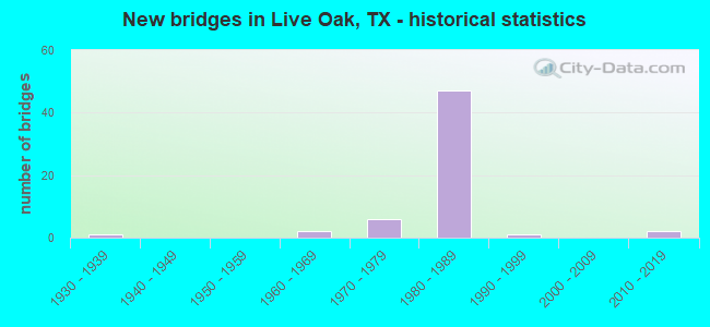
- New bridges - historical statistics
- 11930-1939
- 21960-1969
- 61970-1979
- 471980-1989
- 11990-1999
- 22010-2019
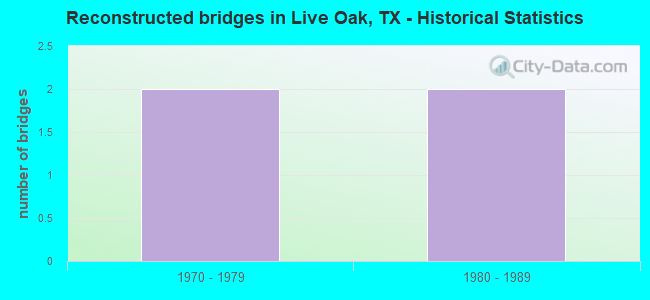
- Reconstructed bridges - Historical Statistics
- 21970-1979
- 21980-1989
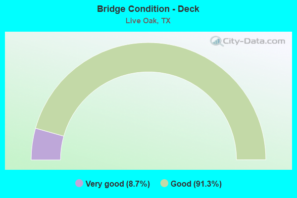
- Bridge Condition - Deck
- 8.7%Very good
- 91.3%Good
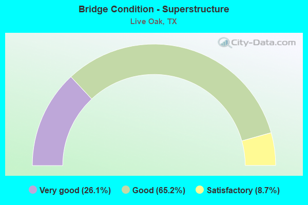
- Bridge Condition - Superstructure
- 26.1%Very good
- 65.2%Good
- 8.7%Satisfactory
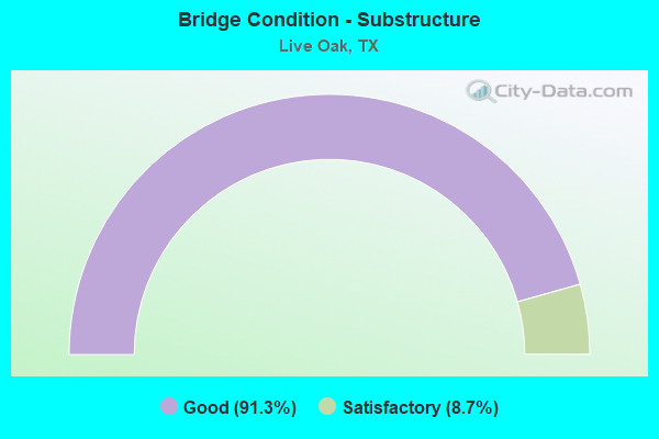
- Bridge Condition - Substructure
- 91.3%Good
- 8.7%Satisfactory
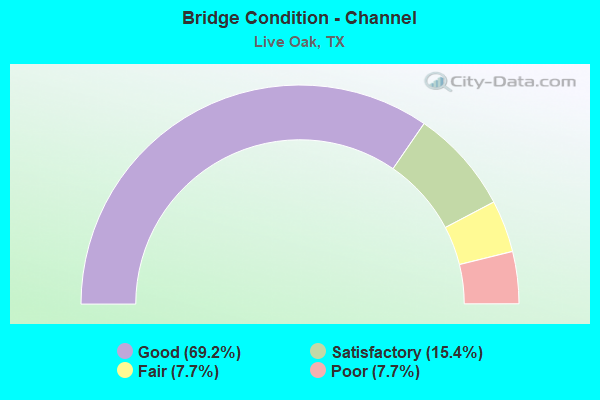
- Bridge Condition - Channel
- 69.2%Good
- 15.4%Satisfactory
- 7.7%Fair
- 7.7%Poor
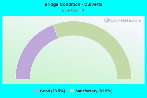
- Bridge Condition - Culverts
- 38.5%Good
- 61.5%Satisfactory
Find on map >> Show street view
Structure Number: 150150245203065, Location: 0.2 Mi NW of IH 35 (Lat: 29.569819, Lng: -98.335036), Route carried "under" structure: City street , Year Built: 1987, Structure Length: 0. m, Average Daily Traffic: 275 (year 2014), Truck Traffic: 1%, Features Intersected: Point NE Pkwy, Facility Carried by Structure: LP 1604 WBML
Minimum Vertical Clearance: 6.20m (20.34ft), Kilometerpoint: 1.300, Lanes on structure: 2, Lanes under structure: 4, Material/Design: Prestressed concrete, Design/Construction: Stringer/Multi-beam, Length of Maximum Span: 13.1m (43.0ft)
Find on map >> Show street view
Structure Number: 150150245203066, Location: 0.2 Mi NW of IH 35 (Lat: 29.569625, Lng: -98.335314), Route carried "under" structure: City street , Year Built: 1987, Structure Length: 0. m, Average Daily Traffic: 275 (year 2014), Truck Traffic: 1%, Features Intersected: Point NE Pkwy, Facility Carried by Structure: LP 1604 EBFR & A
Minimum Vertical Clearance: 5.69m (18.67ft), Kilometerpoint: 1.300, Lanes on structure: 2, Lanes under structure: 4, Material/Design: Prestressed concrete, Design/Construction: Stringer/Multi-beam, Length of Maximum Span: 13.1m (43.0ft)
Find on map >> Show street view
Structure Number: 150150245203067, Location: 0.1 Mi SE of IH 35 (Lat: 29.566808, Lng: -98.331725), Route carried "under" structure: Ramp State highway 1604, Year Built: 1987, Structure Length: 0. m, Average Daily Traffic: 2,400 (year 2014), Truck Traffic: 1%, Features Intersected: LP 1604 LP A
Minimum Vertical Clearance: 7.49m (24.57ft), Kilometerpoint: 60.679, Lanes on structure: 1, Lanes under structure: 1, Material/Design: Prestressed concrete, Design/Construction: Stringer/Multi-beam, Length of Maximum Span: 17.4m (57.1ft)
Find on map >> Show street view
Structure Number: 150150245203068, Location: 0.1 Mi SE of IH 35 (Lat: 29.566711, Lng: -98.332122), Route carried "under" structure: Ramp State highway 1604, Year Built: 1987, Structure Length: 0. m, Average Daily Traffic: 2,400 (year 2014), Truck Traffic: 1%, Features Intersected: LP 1604 LP A
Minimum Vertical Clearance: 6.17m (20.24ft), Kilometerpoint: 60.679, Lanes on structure: 2, Lanes under structure: 1, Material/Design: Prestressed concrete, Design/Construction: Stringer/Multi-beam, Length of Maximum Span: 17.4m (57.1ft)
Find on map >> Show street view
Structure Number: 150150245203069, Location: 0.1 Mi SE of IH 35 (Lat: 29.566656, Lng: -98.332239), Route carried "under" structure: Ramp State highway 1604, Year Built: 1987, Structure Length: 0. m, Average Daily Traffic: 2,400 (year 2014), Truck Traffic: 1%, Features Intersected: LP 1604 LP A
Minimum Vertical Clearance: 5.79m (19.00ft), Kilometerpoint: 60.679, Lanes on structure: 1, Lanes under structure: 1, Material/Design: Prestressed concrete, Design/Construction: Stringer/Multi-beam, Length of Maximum Span: 17.4m (57.1ft)
Find on map >> Show street view
Structure Number: 150150245203071, Location: 0.2 Mi NW of IH 35 (Lat: 29.569761, Lng: -98.335125), Route carried "under" structure: City street , Year Built: 1987, Structure Length: 0. m, Average Daily Traffic: 275 (year 2014), Truck Traffic: 1%, Features Intersected: Point NE Pkwy, Facility Carried by Structure: LP 1604 EBML
Minimum Vertical Clearance: 6.38m (20.93ft), Kilometerpoint: 1.300, Lanes on structure: 2, Lanes under structure: 4, Material/Design: Prestressed concrete, Design/Construction: Stringer/Multi-beam, Length of Maximum Span: 13.1m (43.0ft)
Find on map >> Show street view
Structure Number: 150150245203072, Location: 0.1 Mi SE of IH 35 (Lat: 29.566744, Lng: -98.331844), Route carried "under" structure: Ramp State highway 1604, Year Built: 1987, Structure Length: 0. m, Average Daily Traffic: 2,400 (year 2014), Truck Traffic: 1%, Features Intersected: LP 1604 LP A
Minimum Vertical Clearance: 7.26m (23.82ft), Kilometerpoint: 60.679, Lanes on structure: 2, Lanes under structure: 1, Material/Design: Prestressed concrete, Design/Construction: Stringer/Multi-beam, Length of Maximum Span: 17.4m (57.1ft)
Find on map >> Show street view
Structure Number: 15015024520321, Location: 0.9 Mi NW of IH 35 (Lat: 29.578261, Lng: -98.342408), Route carried "under" structure: City street 208, Year Built: 1988, Structure Length: 0. m, Average Daily Traffic: 3,230 (year 2014), Truck Traffic: 1%, Features Intersected: Lookout Rd, Facility Carried by Structure: LP 1604 WB
Minimum Vertical Clearance: 5.72m (18.77ft), Kilometerpoint: 6.198, Lanes on structure: 2, Lanes under structure: 4, Material/Design: Prestressed concrete, Design/Construction: Stringer/Multi-beam, Length of Maximum Span: 30.5m (100.1ft)
Find on map >> Show street view
Structure Number: 150150245203212, Location: 0.70 Mi NW of IH 35 (Lat: 29.576653, Lng: -98.341764), Route carried "under" structure: Ramp State highway 1604, Year Built: 1988, Structure Length: 0. m, Average Daily Traffic: 7,830 (year 2014), Truck Traffic: 4%, Features Intersected: On Ramp R
Minimum Vertical Clearance: 5.41m (17.75ft), Kilometerpoint: 59.216, Lanes on structure: 1, Lanes under structure: 1, Material/Design: Prestressed concrete, Design/Construction: Stringer/Multi-beam, Length of Maximum Span: 36.6m (120.1ft)