Bridge Statistics for Loveland, Colorado (CO)
Condition, Traffic, Stress, Structural Evaluation, Project Costs
- National Bridge Inventory (NBI) Statistics
- 102Number of bridges
- 656ft / 200mTotal length
- $5,029,000Total costs
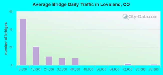
- 1,306,550Total average daily traffic
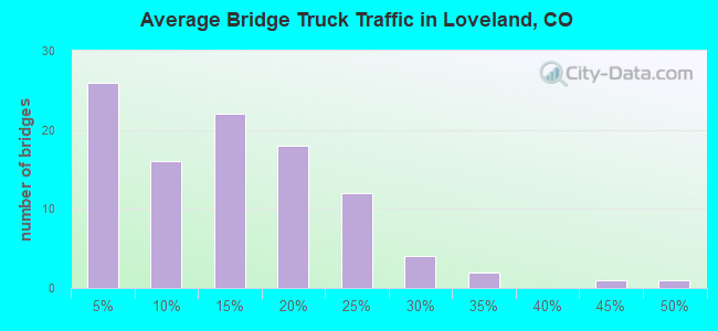
- 124,627Total average daily truck traffic
- National Bridge Inventory (NBI) Registered Bridges for Loveland
- No street view available for this location
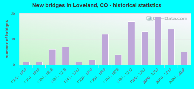
- New bridges - historical statistics
- 11900-1909
- 11910-1919
- 61920-1929
- 71930-1939
- 11940-1949
- 21950-1959
- 121960-1969
- 41970-1979
- 171980-1989
- 131990-1999
- 192000-2009
- 142010-2019
- 52020-2022
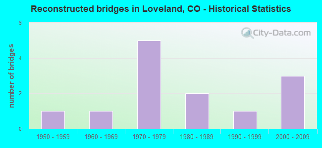
- Reconstructed bridges - Historical Statistics
- 11950-1959
- 11960-1969
- 51970-1979
- 21980-1989
- 11990-1999
- 32000-2009

- Bridge Condition - Deck
- 9.4%Very good
- 50.0%Good
- 29.7%Satisfactory
- 7.8%Fair
- 1.6%Poor
- 1.6%Serious
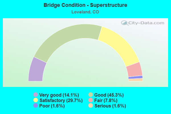
- Bridge Condition - Superstructure
- 14.1%Very good
- 45.3%Good
- 29.7%Satisfactory
- 7.8%Fair
- 1.6%Poor
- 1.6%Serious
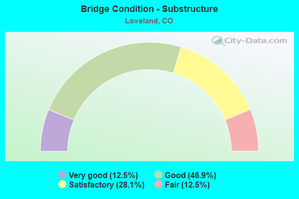
- Bridge Condition - Substructure
- 12.5%Very good
- 46.9%Good
- 28.1%Satisfactory
- 12.5%Fair
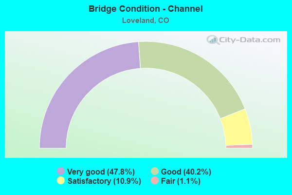
- Bridge Condition - Channel
- 47.8%Very good
- 40.2%Good
- 10.9%Satisfactory
- 1.1%Fair
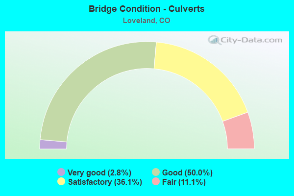
- Bridge Condition - Culverts
- 2.8%Very good
- 50.0%Good
- 36.1%Satisfactory
- 11.1%Fair
Find on map >> Show street view
Structure Number: C-16-AB, Location: 3.5 MI N OF JCT US 34 (Lat: 40.457956, Lng: -105.077128), Route carried "on" structure: ServiceUS 287C, Year Built: 1950, Status: Posted for load, Structure Length: 0.75m (2.46ft), Average Daily Traffic: 34,000 (year 2020), Truck Traffic: 3%, Average Future Daily Traffic: 42,840 (year 2040), Features Intersected: LOUDEN CANAL, Facility Carried by Structure: US 287 ML AR
Minimum Vertical Clearance: 30+ m (98+ ft), Kilometerpoint: 87.452, Lanes on structure: 2, Base Highway Network: Yes, Owner: State Highway Agency, Approaching Roadway Width: 4.6m (15.1ft), Material/Design: Wood or Timber, Design/Construction: Stringer/Multi-beam, Number Of Spans In Main Unit: 1, Length of Maximum Span: 7.0m (23.0ft), Curb-To-Curb Width: 5.9m (19.4ft), Out-to-Out Width: 6.2m (20.3ft)
Condition: Deck: Fair, Superstructure: Satisfactory, Substructure: Satisfactory, Channel: Fair, Operating Rating: 28.6 metric tons, Method Used To Determine Operating Rating: Allowable Stress (AS), Inventory Rating: 17.5 metric tons, Method Used To Determine Inventory Rating: Allowable Stress (AS), Structural Evaluation: Meets minimum limits, Deck Geometry: High priority of replacement, Waterway Adequacy: Equal to present desirable criteria, Approach Roadway Alignment: Equal to present minimum criteria, Length Of Structure Improvement: 1.38m (4.53ft), Designated Inspection Frequency: Every 24 months, Inspection Date: November 2021, Bridge Improvement Cost: $78,000, Roadway Improvement Cost: $8,000, Total Project Cost: $118,000 ( Estimate for 2015), Deck Structure Type: Wood or Timber, Wearing Surface/Protective System: Wearing Surface: Wood or Timber
Find on map >> Show street view
Structure Number: C-16-AE, Location: 1 MI W OF LOVELAND (Lat: 40.410800, Lng: -105.166100), Route carried "on" structure: US 34A, Year Built: 1992, Status: Open, Structure Length: 10.19m (33.43ft), Average Daily Traffic: 8,300 (year 2020), Truck Traffic: 4%, Average Future Daily Traffic: 9,628 (year 2040), Design Load: HS 20+Mod, Features Intersected: BIG THOMPSON RIVER, Facility Carried by Structure: US 34 ML
Minimum Vertical Clearance: 30+ m (98+ ft), Kilometerpoint: 139.205, Lanes on structure: 2, Base Highway Network: Yes, Owner: State Highway Agency, Approaching Roadway Width: 12.2m (40.0ft), Skew: 4 degrees, Material/Design: Prestressed concrete continuous, Design/Construction: Stringer/Multi-beam, Number Of Spans In Main Unit: 3, Length of Maximum Span: 33.8m (110.9ft), Curb-To-Curb Width: 12.2m (40.0ft), Out-to-Out Width: 13.0m (42.7ft)
Condition: Deck: Good, Superstructure: Good, Substructure: Good, Channel: Very good, Operating Rating: 48.0 metric tons, Method Used To Determine Operating Rating: Load Factor (LF), Inventory Rating: 20.5 metric tons, Method Used To Determine Inventory Rating: Load Factor (LF), Structural Evaluation: Somewhat better than minimum adequacy, Deck Geometry: Somewhat better than minimum adequacy, Waterway Adequacy: Equal to present desirable criteria, Approach Roadway Alignment: Equal to present desirable criteria, Designated Inspection Frequency: Every 24 months, Inspection Date: September 2021, Deck Structure Type: Concrete Cast-file-Place, Wearing Surface/Protective System: Wearing Surface: Bituminous, Membrane: Preformed Fabric, Deck Protection: Epoxy Coated Reinforcing
Find on map >> Show street view
Structure Number: C-16-AF, Location: 2 MI WEST OF LOVELAND (Lat: 40.419100, Lng: -105.177500), Route carried "on" structure: US 34A, Year Built: 1997, Status: Open, Structure Length: 0.82m (2.69ft), Average Daily Traffic: 8,300 (year 2020), Truck Traffic: 4%, Average Future Daily Traffic: 9,628 (year 2040), Design Load: H 20, Features Intersected: BUCKINGHAM DITCH, Facility Carried by Structure: US 34 ML
Minimum Vertical Clearance: 30+ m (98+ ft), Kilometerpoint: 137.835, Lanes on structure: 2, Base Highway Network: Yes, Owner: State Highway Agency, Approaching Roadway Width: 10.7m (35.1ft), Skew: 6 degrees, Material/Design: Concrete, Design/Construction: Culvert, Number Of Spans In Main Unit: 1, Length of Maximum Span: 8.2m (26.9ft), Curb-To-Curb Width: 11.9m (39.0ft), Out-to-Out Width: 19.1m (62.7ft)
Condition: Channel: Very good, Culverts: Satisfactory, Operating Rating: 89.8 metric tons, Method Used To Determine Operating Rating: Field evaluation and documented engineering judgment, Inventory Rating: 89.8 metric tons, Method Used To Determine Inventory Rating: Field evaluation and documented engineering judgment, Structural Evaluation: Equal to present minimum criteria, Deck Geometry: Somewhat better than minimum adequacy, Waterway Adequacy: Equal to present desirable criteria, Approach Roadway Alignment: Equal to present minimum criteria, Designated Inspection Frequency: Every 24 months, Inspection Date: November 2021
Find on map >> Show street view
Structure Number: C-16-AG, Location: 3.5 MI W OF LOVELAND (Lat: 40.411500, Lng: -105.203300), Route carried "on" structure: US 34A, Year Built: 1933, Status: Open, Structure Length: 0.75m (2.46ft), Average Daily Traffic: 4,900 (year 2020), Truck Traffic: 4%, Average Future Daily Traffic: 5,684 (year 2040), Design Load: HS 20+Mod, Features Intersected: HOME SUPPLY DITCH, Facility Carried by Structure: US 34 ML
Minimum Vertical Clearance: 30+ m (98+ ft), Kilometerpoint: 135.376, Lanes on structure: 2, Base Highway Network: Yes, Owner: State Highway Agency, Approaching Roadway Width: 10.1m (33.1ft), Skew: 1 degrees, Material/Design: Steel, Design/Construction: Stringer/Multi-beam, Number Of Spans In Main Unit: 1, Length of Maximum Span: 6.7m (22.0ft), Curb-To-Curb Width: 9.1m (29.9ft), Out-to-Out Width: 10.2m (33.5ft)
Condition: Deck: Satisfactory, Superstructure: Satisfactory, Substructure: Satisfactory, Channel: Good, Operating Rating: 42.1 metric tons, Method Used To Determine Operating Rating: Load Factor (LF), Inventory Rating: 25.2 metric tons, Method Used To Determine Inventory Rating: Load Factor (LF), Structural Evaluation: Equal to present minimum criteria, Deck Geometry: Meets minimum limits, Waterway Adequacy: Equal to present desirable criteria, Approach Roadway Alignment: Equal to present desirable criteria, Length Of Structure Improvement: 0.76m (2.49ft), Designated Inspection Frequency: Every 24 months, Inspection Date: November 2021, Bridge Improvement Cost: $30,000, Roadway Improvement Cost: $3,000, Total Project Cost: $45,000 ( Estimate for 2015), Deck Structure Type: Concrete Cast-file-Place, Wearing Surface/Protective System: Wearing Surface: Bituminous
Find on map >> Show street view
Structure Number: C-16-AH, Location: 3.7 MI WEST OF LOVELAND (Lat: 40.411100, Lng: -105.207000), Route carried "on" structure: US 34A, Year Built: 1933, Status: Open, Structure Length: 0.85m (2.79ft), Average Daily Traffic: 4,900 (year 2020), Truck Traffic: 4%, Average Future Daily Traffic: 5,684 (year 2040), Design Load: HS 20+Mod, Features Intersected: HANDY DITCH, Facility Carried by Structure: US 34 ML
Minimum Vertical Clearance: 30+ m (98+ ft), Kilometerpoint: 135.055, Lanes on structure: 2, Base Highway Network: Yes, Owner: State Highway Agency, Approaching Roadway Width: 10.1m (33.1ft), Skew: 3 degrees, Material/Design: Steel, Design/Construction: Stringer/Multi-beam, Number Of Spans In Main Unit: 1, Length of Maximum Span: 7.3m (24.0ft), Curb-To-Curb Width: 9.1m (29.9ft), Out-to-Out Width: 10.2m (33.5ft)
Condition: Deck: Satisfactory, Superstructure: Satisfactory, Substructure: Satisfactory, Channel: Very good, Operating Rating: 39.3 metric tons, Method Used To Determine Operating Rating: Load Factor (LF), Inventory Rating: 23.5 metric tons, Method Used To Determine Inventory Rating: Load Factor (LF), Structural Evaluation: Equal to present minimum criteria, Deck Geometry: Meets minimum limits, Waterway Adequacy: Equal to present desirable criteria, Approach Roadway Alignment: Better than present minimum criteria, Length Of Structure Improvement: 0.85m (2.79ft), Designated Inspection Frequency: Every 24 months, Inspection Date: November 2021, Bridge Improvement Cost: $34,000, Roadway Improvement Cost: $3,000, Total Project Cost: $51,000 ( Estimate for 2015), Deck Structure Type: Concrete Cast-file-Place, Wearing Surface/Protective System: Wearing Surface: Bituminous
Find on map >> Show street view
Structure Number: C-16-AI, Location: 3.8 MI W OF LOVELAND (Lat: 40.410769, Lng: -105.211206), Route carried "on" structure: US 34A, Year Built: 1933, Status: Open, Structure Length: 1.05m (3.44ft), Average Daily Traffic: 4,900 (year 2020), Truck Traffic: 4%, Average Future Daily Traffic: 5,684 (year 2040), Design Load: HS 20+Mod, Features Intersected: DRAW, Facility Carried by Structure: US 34 ML
Minimum Vertical Clearance: 30+ m (98+ ft), Kilometerpoint: 134.691, Lanes on structure: 2, Base Highway Network: Yes, Owner: State Highway Agency, Approaching Roadway Width: 9.8m (32.2ft), Skew: 4 degrees, Material/Design: Steel, Design/Construction: Stringer/Multi-beam, Number Of Spans In Main Unit: 1, Length of Maximum Span: 9.8m (32.2ft), Curb-To-Curb Width: 9.1m (29.9ft), Out-to-Out Width: 10.2m (33.5ft)
Condition: Deck: Satisfactory, Superstructure: Satisfactory, Substructure: Fair, Channel: Good, Operating Rating: 33.7 metric tons, Method Used To Determine Operating Rating: Load Factor (LF), Inventory Rating: 20.2 metric tons, Method Used To Determine Inventory Rating: Load Factor (LF), Structural Evaluation: Somewhat better than minimum adequacy, Deck Geometry: Meets minimum limits, Waterway Adequacy: Superior to present desirable criteria, Approach Roadway Alignment: Equal to present desirable criteria, Length Of Structure Improvement: 1.05m (3.44ft), Designated Inspection Frequency: Every 24 months, Inspection Date: September 2021, Bridge Improvement Cost: $161,000, Roadway Improvement Cost: $16,000, Total Project Cost: $177,000 ( Estimate for 2017), Deck Structure Type: Concrete Cast-file-Place, Wearing Surface/Protective System: Wearing Surface: Bituminous
Find on map >> Show street view
Structure Number: C-16-AQ, Location: 0.1 MI W. OF US 287 (Lat: 40.407300, Lng: -105.075800), Route carried "on" structure: US 34A, Year Built: 1999, Status: Open, Structure Length: 3.40m (11.15ft), Average Daily Traffic: 26,000 (year 2020), Truck Traffic: 3%, Average Future Daily Traffic: 31,720 (year 2040), Design Load: HS 25 or greater, Features Intersected: BNSF RR, Facility Carried by Structure: US 34 ML
Minimum Vertical Clearance: 30+ m (98+ ft), Kilometerpoint: 147.092, Lanes on structure: 4, Base Highway Network: Yes, Owner: State Highway Agency, Approaching Roadway Width: 18.3m (60.0ft), Skew: 20 degrees, Material/Design: Prestressed concrete, Design/Construction: Box Beam or Girders - Multiple, Number Of Spans In Main Unit: 1, Length of Maximum Span: 33.2m (108.9ft), Curb or Sidewalk Widths: Left: 1.7m (5.6ft), Right: 1.7m (5.6ft), Curb-To-Curb Width: 21.9m (71.9ft), Out-to-Out Width: 26.2m (86.0ft)
Condition: Deck: Good, Superstructure: Good, Substructure: Good, Operating Rating: 89.8 metric tons, Method Used To Determine Operating Rating: Load Factor (LF), Inventory Rating: 43.7 metric tons, Method Used To Determine Inventory Rating: Load Factor (LF), Structural Evaluation: Better than present minimum criteria, Deck Geometry: Superior to present desirable criteria, Underclear: Better than present minimum criteria, Approach Roadway Alignment: Equal to present desirable criteria, Designated Inspection Frequency: Every 24 months, Inspection Date: September 2021, Deck Structure Type: Concrete Cast-file-Place, Wearing Surface/Protective System: Wearing Surface: Bituminous, Membrane: Built-up, Deck Protection: Epoxy Coated Reinforcing
Find on map >> Show street view
Structure Number: C-16-AR, Location: AT W. END OF LOVELAND (Lat: 40.408183, Lng: -105.152944), Route carried "on" structure: US 34A, Year Built: 1998, Status: Open, Structure Length: 2.20m (7.22ft), Average Daily Traffic: 8,300 (year 2020), Truck Traffic: 4%, Average Future Daily Traffic: 9,628 (year 2040), Design Load: HS 25 or greater, Features Intersected: DRAW, Facility Carried by Structure: US 34 ML
Minimum Vertical Clearance: 30+ m (98+ ft), Kilometerpoint: 140.359, Lanes on structure: 2, Base Highway Network: Yes, Owner: State Highway Agency, Approaching Roadway Width: 12.2m (40.0ft), Skew: 4 degrees, Material/Design: Concrete, Design/Construction: Culvert, Number Of Spans In Main Unit: 2, Length of Maximum Span: 8.6m (28.2ft), Out-to-Out Width: 55.2m (181.1ft)
Condition: Channel: Very good, Culverts: Satisfactory, Operating Rating: 89.8 metric tons, Method Used To Determine Operating Rating: Field evaluation and documented engineering judgment, Inventory Rating: 89.8 metric tons, Method Used To Determine Inventory Rating: Field evaluation and documented engineering judgment, Structural Evaluation: Equal to present minimum criteria, Waterway Adequacy: Equal to present desirable criteria, Approach Roadway Alignment: Equal to present desirable criteria, Designated Inspection Frequency: Every 24 months, Inspection Date: September 2021
Find on map >> Show street view
Structure Number: C-16-BH, Location: CLEVELAND AVE at 1st ST (Lat: 40.392900, Lng: -105.074500), Route carried "on" structure: US 287Z, Year Built: 2003, Status: Open, Structure Length: 1.36m (4.46ft), Average Daily Traffic: 5,500 (year 2020), Truck Traffic: 6%, Average Future Daily Traffic: 5,885 (year 2040), Design Load: HL 93, Features Intersected: GREELEY-LOVELAND CANAL, Facility Carried by Structure: US 287 SBND
Minimum Vertical Clearance: 30+ m (98+ ft), Kilometerpoint: 2.131, Lanes on structure: 4, Base Highway Network: Yes, Owner: State Highway Agency, Approaching Roadway Width: 17.4m (57.1ft), Material/Design: Prestressed concrete, Design/Construction: Slab, Number Of Spans In Main Unit: 1, Length of Maximum Span: 12.6m (41.3ft), Curb or Sidewalk Widths: Left: 1.9m (6.2ft), Right: 1.9m (6.2ft), Curb-To-Curb Width: 17.4m (57.1ft), Out-to-Out Width: 22.3m (73.2ft)
Condition: Deck: Good, Superstructure: Good, Substructure: Very good, Channel: Very good, Operating Rating: 35.6 metric tons, Method Used To Determine Operating Rating: Load and Resistance Factor Rating (LRFR) rating reported by rating factor(RF) method using HL-93 loadings, Inventory Rating: 27.5 metric tons, Method Used To Determine Inventory Rating: Load and Resistance Factor Rating (LRFR) rating reported by rating factor(RF) method using HL-93 loadings, Structural Evaluation: Equal to present minimum criteria, Deck Geometry: Somewhat better than minimum adequacy, Waterway Adequacy: Equal to present desirable criteria, Approach Roadway Alignment: Equal to present desirable criteria, Designated Inspection Frequency: Every 24 months, Inspection Date: November 2021, Deck Structure Type: Concrete Cast-file-Place, Wearing Surface/Protective System: Wearing Surface: Bituminous, Membrane: Built-up, Deck Protection: Epoxy Coated Reinforcing
Find on map >> Show street view
Structure Number: C-16-BI, Location: LINCOLN AVE at 1st ST (Lat: 40.393000, Lng: -105.073200), Route carried "on" structure: US 287C, Year Built: 2002, Status: Open, Structure Length: 1.38m (4.53ft), Average Daily Traffic: 4,950 (year 2020), Truck Traffic: 4%, Average Future Daily Traffic: 5,792 (year 2040), Design Load: HL 93, Features Intersected: GREELEY-LOVELAND CANAL, Facility Carried by Structure: US 287 NBND
Minimum Vertical Clearance: 30+ m (98+ ft), Kilometerpoint: 80.112, Lanes on structure: 2, Base Highway Network: Yes, Owner: State Highway Agency, Approaching Roadway Width: 15.8m (51.8ft), Material/Design: Prestressed concrete, Design/Construction: Slab, Number Of Spans In Main Unit: 1, Length of Maximum Span: 12.0m (39.4ft), Curb or Sidewalk Widths: Left: 1.9m (6.2ft), Right: 1.9m (6.2ft), Curb-To-Curb Width: 13.7m (44.9ft), Out-to-Out Width: 18.6m (61.0ft)
Condition: Deck: Good, Superstructure: Good, Substructure: Good, Channel: Very good, Operating Rating: 52.2 metric tons, Method Used To Determine Operating Rating: Load and Resistance Factor Rating (LRFR) rating reported by rating factor(RF) method using HL-93 loadings, Inventory Rating: 40.2 metric tons, Method Used To Determine Inventory Rating: Load and Resistance Factor Rating (LRFR) rating reported by rating factor(RF) method using HL-93 loadings, Structural Evaluation: Better than present minimum criteria, Deck Geometry: Superior to present desirable criteria, Waterway Adequacy: Equal to present desirable criteria, Approach Roadway Alignment: Equal to present desirable criteria, Designated Inspection Frequency: Every 24 months, Inspection Date: November 2021, Deck Structure Type: Concrete Precast Panels, Wearing Surface/Protective System: Wearing Surface: Bituminous, Membrane: Built-up, Deck Protection: Epoxy Coated Reinforcing
Find on map >> Show street view
Structure Number: C-16-DA, Location: 3 MI W OF LOVELAND (Lat: 40.414861, Lng: -105.195753), Route carried "on" structure: US 34A, Year Built: 2005, Status: Open, Structure Length: 4.54m (14.90ft), Average Daily Traffic: 6,900 (year 2020), Truck Traffic: 4%, Average Future Daily Traffic: 7,935 (year 2040), Design Load: HS 25 or greater, Features Intersected: BIG THOMPSON RIVER, Facility Carried by Structure: US 34 ML
Minimum Vertical Clearance: 30+ m (98+ ft), Kilometerpoint: 136.146, Lanes on structure: 2, Base Highway Network: Yes, Owner: State Highway Agency, Approaching Roadway Width: 12.2m (40.0ft), Skew: 2 degrees, Material/Design: Prestressed concrete continuous, Design/Construction: Box Beam or Girders - Multiple, Number Of Spans In Main Unit: 2, Length of Maximum Span: 21.9m (71.9ft), Curb-To-Curb Width: 12.2m (40.0ft), Out-to-Out Width: 13.1m (43.0ft)
Condition: Deck: Good, Superstructure: Good, Substructure: Good, Channel: Good, Operating Rating: 72.0 metric tons, Method Used To Determine Operating Rating: Load Factor (LF), Inventory Rating: 43.2 metric tons, Method Used To Determine Inventory Rating: Load Factor (LF), Structural Evaluation: Better than present minimum criteria, Deck Geometry: Somewhat better than minimum adequacy, Waterway Adequacy: Better than present minimum criteria, Approach Roadway Alignment: Equal to present desirable criteria, Designated Inspection Frequency: Every 24 months, Inspection Date: September 2021, Deck Structure Type: Concrete Cast-file-Place, Wearing Surface/Protective System: Wearing Surface: Bituminous, Membrane: Built-up, Deck Protection: Epoxy Coated Reinforcing
Find on map >> Show street view
Structure Number: C-16-DD, Location: 2 MI W OF LOVELAND (Lat: 40.418631, Lng: -105.180558), Route carried "on" structure: US 34A, Year Built: 2005, Status: Open, Structure Length: 6.68m (21.92ft), Average Daily Traffic: 8,300 (year 2020), Truck Traffic: 4%, Average Future Daily Traffic: 9,628 (year 2040), Design Load: HS 25 or greater, Features Intersected: BIG THOMPSON RIVER, Facility Carried by Structure: US 34 ML
Minimum Vertical Clearance: 30+ m (98+ ft), Kilometerpoint: 137.567, Lanes on structure: 2, Base Highway Network: Yes, Owner: State Highway Agency, Approaching Roadway Width: 12.2m (40.0ft), Skew: 3 degrees, Material/Design: Prestressed concrete, Design/Construction: Box Beam or Girders - Multiple, Number Of Spans In Main Unit: 3, Length of Maximum Span: 22.1m (72.5ft), Curb-To-Curb Width: 12.2m (40.0ft), Out-to-Out Width: 13.1m (43.0ft)
Condition: Deck: Very good, Superstructure: Good, Substructure: Satisfactory, Channel: Very good, Operating Rating: 74.8 metric tons, Method Used To Determine Operating Rating: Load Factor (LF), Inventory Rating: 44.7 metric tons, Method Used To Determine Inventory Rating: Load Factor (LF), Structural Evaluation: Equal to present minimum criteria, Deck Geometry: Somewhat better than minimum adequacy, Waterway Adequacy: Equal to present desirable criteria, Approach Roadway Alignment: Equal to present desirable criteria, Designated Inspection Frequency: Every 24 months, Inspection Date: September 2021, Deck Structure Type: Concrete Cast-file-Place, Wearing Surface/Protective System: Wearing Surface: Bituminous, Membrane: Built-up, Deck Protection: Epoxy Coated Reinforcing
Find on map >> Show street view
Structure Number: C-16-DH, Location: IN LOVELAND AT LAKE (Lat: 40.405086, Lng: -105.091400), Route carried "on" structure: US 34A, Year Built: 1969, Status: Open, Structure Length: 1.14m (3.74ft), Average Daily Traffic: 12,500 (year 2020), Truck Traffic: 3%, Average Future Daily Traffic: 15,375 (year 2040), Design Load: HS 20, Features Intersected: BARNES INLET CANAL, Facility Carried by Structure: US 34 ML EBND
Minimum Vertical Clearance: 30+ m (98+ ft), Kilometerpoint: 145.689, Lanes on structure: 2, Base Highway Network: Yes, Owner: State Highway Agency, Approaching Roadway Width: 8.2m (26.9ft), Skew: 20 degrees, Material/Design: Concrete, Design/Construction: Culvert, Number Of Spans In Main Unit: 3, Length of Maximum Span: 3.7m (12.1ft), Out-to-Out Width: 13.9m (45.6ft)
Condition: Channel: Good, Culverts: Satisfactory, Operating Rating: 36.3 metric tons, Method Used To Determine Operating Rating: Field evaluation and documented engineering judgment, Inventory Rating: 32.7 metric tons, Method Used To Determine Inventory Rating: Field evaluation and documented engineering judgment, Structural Evaluation: Equal to present minimum criteria, Waterway Adequacy: Equal to present desirable criteria, Approach Roadway Alignment: Better than present minimum criteria, Designated Inspection Frequency: Every 24 months, Inspection Date: November 2021
Find on map >> Show street view
Structure Number: C-16-DL, Location: 1 MI. N. OF CO RD 8 (Lat: 40.322153, Lng: -105.102625), Route carried "on" structure: US 287C, Year Built: 2003, Status: Open, Structure Length: 0.74m (2.43ft), Average Daily Traffic: 18,000 (year 2020), Truck Traffic: 3%, Average Future Daily Traffic: 27,000 (year 2040), Design Load: HL 93, Features Intersected: HANDY DITCH, Facility Carried by Structure: US 287 ML
Minimum Vertical Clearance: 30+ m (98+ ft), Kilometerpoint: 70.373, Lanes on structure: 4, Base Highway Network: Yes, Owner: State Highway Agency, Approaching Roadway Width: 23.2m (76.1ft), Skew: 4 degrees, Material/Design: Concrete, Design/Construction: Culvert, Number Of Spans In Main Unit: 1, Length of Maximum Span: 7.4m (24.3ft), Out-to-Out Width: 53.3m (174.9ft)
Condition: Channel: Good, Culverts: Satisfactory, Operating Rating: 96.9 metric tons, Method Used To Determine Operating Rating: Load and Resistance Factor Rating (LRFR) rating reported by rating factor(RF) method using HL-93 loadings, Inventory Rating: 89.1 metric tons, Method Used To Determine Inventory Rating: Load and Resistance Factor Rating (LRFR) rating reported by rating factor(RF) method using HL-93 loadings, Structural Evaluation: Equal to present minimum criteria, Waterway Adequacy: Equal to present desirable criteria, Approach Roadway Alignment: Equal to present desirable criteria, Designated Inspection Frequency: Every 24 months, Inspection Date: November 2021
Find on map >> Show street view
Structure Number: C-16-H, Location: 0.4 MI N OF JCT SH 402 (Lat: 40.383153, Lng: -105.073242), Route carried "on" structure: US 287C, Year Built: 1950, Year Reconstructed: 1975, Status: Open, Structure Length: 3.15m (10.33ft), Average Daily Traffic: 18,000 (year 2020), Truck Traffic: 5%, Average Future Daily Traffic: 21,960 (year 2040), Design Load: H 20, Features Intersected: BIG THOMPSON RIVER, Facility Carried by Structure: US 287 ML
Minimum Vertical Clearance: 30+ m (98+ ft), Kilometerpoint: 79.014, Lanes on structure: 5, Base Highway Network: Yes, Owner: State Highway Agency, Approaching Roadway Width: 26.8m (87.9ft), Material/Design: Steel continuous, Design/Construction: Stringer/Multi-beam, Number Of Spans In Main Unit: 3, Length of Maximum Span: 11.6m (38.1ft), Curb or Sidewalk Widths: Left: 1.5m (4.9ft), Right: 1.7m (5.6ft), Curb-To-Curb Width: 26.8m (87.9ft), Out-to-Out Width: 30.6m (100.4ft)
Condition: Deck: Satisfactory, Superstructure: Satisfactory, Substructure: Fair, Channel: Satisfactory, Operating Rating: 37.2 metric tons, Method Used To Determine Operating Rating: Load Factor (LF), Inventory Rating: 22.2 metric tons, Method Used To Determine Inventory Rating: Load Factor (LF), Structural Evaluation: Somewhat better than minimum adequacy, Deck Geometry: Superior to present desirable criteria, Waterway Adequacy: Equal to present minimum criteria, Approach Roadway Alignment: Equal to present desirable criteria, Designated Inspection Frequency: Every 24 months, Inspection Date: September 2021, Deck Structure Type: Concrete Cast-file-Place, Wearing Surface/Protective System: Wearing Surface: Bituminous, Membrane: Built-up
Find on map >> Show street view
Structure Number: C-16-I, Location: 0.4 MI N of SH60 (Lat: 40.355167, Lng: -105.073536), Route carried "on" structure: US 287C, Year Built: 2005, Status: Open, Structure Length: 0.61m (2.00ft), Average Daily Traffic: 20,000 (year 2020), Truck Traffic: 4%, Average Future Daily Traffic: 28,800 (year 2040), Design Load: HS 25 or greater, Features Intersected: LAKE DITCH, Facility Carried by Structure: US 287 ML
Minimum Vertical Clearance: 30+ m (98+ ft), Kilometerpoint: 75.910, Lanes on structure: 6, Base Highway Network: Yes, Owner: State Highway Agency, Approaching Roadway Width: 29.3m (96.1ft), Material/Design: Concrete, Design/Construction: Culvert, Number Of Spans In Main Unit: 1, Length of Maximum Span: 6.1m (20.0ft), Out-to-Out Width: 68.9m (226.0ft)
Condition: Channel: Very good, Culverts: Satisfactory, Operating Rating: 36.3 metric tons, Method Used To Determine Operating Rating: Field evaluation and documented engineering judgment, Inventory Rating: 32.7 metric tons, Method Used To Determine Inventory Rating: Field evaluation and documented engineering judgment, Structural Evaluation: Equal to present minimum criteria, Waterway Adequacy: Equal to present desirable criteria, Approach Roadway Alignment: Equal to present desirable criteria, Designated Inspection Frequency: Every 24 months, Inspection Date: November 2021
Find on map >> Show street view
Structure Number: C-16-J, Location: 0.1 Mi South of 37th St (Lat: 40.429014, Lng: -105.077225), Route carried "on" structure: US 287C, Year Built: 1924, Year Reconstructed: 1958, Status: Open, Structure Length: 0.77m (2.53ft), Average Daily Traffic: 29,000 (year 2020), Truck Traffic: 3%, Average Future Daily Traffic: 35,090 (year 2040), Design Load: H 20, Features Intersected: DRAW, Facility Carried by Structure: US 287 ML
Minimum Vertical Clearance: 30+ m (98+ ft), Kilometerpoint: 84.238, Lanes on structure: 6, Base Highway Network: Yes, Owner: State Highway Agency, Approaching Roadway Width: 26.8m (87.9ft), Skew: 23 degrees, Material/Design: Concrete, Design/Construction: Culvert, Number Of Spans In Main Unit: 2, Length of Maximum Span: 3.7m (12.1ft), Out-to-Out Width: 42.4m (139.1ft)
Condition: Channel: Satisfactory, Culverts: Satisfactory, Operating Rating: 89.8 metric tons, Method Used To Determine Operating Rating: Field evaluation and documented engineering judgment, Inventory Rating: 89.8 metric tons, Method Used To Determine Inventory Rating: Field evaluation and documented engineering judgment, Structural Evaluation: Equal to present minimum criteria, Waterway Adequacy: Equal to present desirable criteria, Approach Roadway Alignment: Equal to present desirable criteria, Designated Inspection Frequency: Every 24 months, Inspection Date: September 2021
Find on map >> Show street view
Structure Number: C-16-K, Location: 3.2 MI N OF JCT US 34 (Lat: 40.453453, Lng: -105.077200), Route carried "on" structure: US 287C, Year Built: 1924, Year Reconstructed: 1978, Status: Open, Structure Length: 0.67m (2.20ft), Average Daily Traffic: 34,000 (year 2020), Truck Traffic: 3%, Average Future Daily Traffic: 42,840 (year 2040), Design Load: HS 20, Features Intersected: LOUDEN CANAL, Facility Carried by Structure: US 287 ML
Minimum Vertical Clearance: 30+ m (98+ ft), Kilometerpoint: 86.953, Lanes on structure: 4, Base Highway Network: Yes, Owner: State Highway Agency, Approaching Roadway Width: 26.8m (87.9ft), Skew: 4 degrees, Material/Design: Concrete, Design/Construction: Culvert, Number Of Spans In Main Unit: 1, Length of Maximum Span: 6.7m (22.0ft), Out-to-Out Width: 36.3m (119.1ft)
Condition: Channel: Good, Culverts: Satisfactory, Operating Rating: 36.3 metric tons, Method Used To Determine Operating Rating: Field evaluation and documented engineering judgment, Inventory Rating: 32.7 metric tons, Method Used To Determine Inventory Rating: Field evaluation and documented engineering judgment, Structural Evaluation: Equal to present minimum criteria, Waterway Adequacy: Equal to present desirable criteria, Approach Roadway Alignment: Equal to present desirable criteria, Designated Inspection Frequency: Every 24 months, Inspection Date: November 2021
Find on map >> Show street view
Structure Number: C-16-R, Location: 2.2 M. WEST OF LOVELAND (Lat: 40.418308, Lng: -105.182228), Route carried "on" structure: US 34A, Year Built: 1933, Status: Open, Structure Length: 0.71m (2.33ft), Average Daily Traffic: 8,300 (year 2020), Truck Traffic: 4%, Average Future Daily Traffic: 9,628 (year 2040), Design Load: H 15, Features Intersected: LOUDEN DITCH, Facility Carried by Structure: US 34 ML
Minimum Vertical Clearance: 30+ m (98+ ft), Kilometerpoint: 137.422, Lanes on structure: 2, Base Highway Network: Yes, Owner: State Highway Agency, Approaching Roadway Width: 9.4m (30.8ft), Skew: 3 degrees, Material/Design: Concrete, Design/Construction: Frame, Number Of Spans In Main Unit: 1, Length of Maximum Span: 6.2m (20.3ft), Curb-To-Curb Width: 9.1m (29.9ft), Out-to-Out Width: 10.2m (33.5ft)
Condition: Deck: Satisfactory, Superstructure: Satisfactory, Substructure: Satisfactory, Channel: Very good, Operating Rating: 36.3 metric tons, Method Used To Determine Operating Rating: Load Factor (LF), Inventory Rating: 32.7 metric tons, Method Used To Determine Inventory Rating: Load Factor (LF), Structural Evaluation: Equal to present minimum criteria, Deck Geometry: High priority of corrective action, Waterway Adequacy: Equal to present desirable criteria, Approach Roadway Alignment: Better than present minimum criteria, Length Of Structure Improvement: 0.70m (2.30ft), Designated Inspection Frequency: Every 24 months, Inspection Date: November 2021, Bridge Improvement Cost: $28,000, Roadway Improvement Cost: $3,000, Total Project Cost: $42,000 ( Estimate for 2015), Deck Structure Type: Concrete Cast-file-Place, Wearing Surface/Protective System: Wearing Surface: Bituminous
Find on map >> Show street view
Structure Number: C-16-T, Location: 1.2 MI E OF JCT US 287 (Lat: 40.407264, Lng: -105.049961), Route carried "on" structure: US 34A, Year Built: 1965, Status: Open, Structure Length: 0.98m (3.22ft), Average Daily Traffic: 22,000 (year 2020), Truck Traffic: 4%, Average Future Daily Traffic: 31,240 (year 2040), Design Load: H 20, Features Intersected: LOVELAND-GREELEY CANAL, Facility Carried by Structure: US 34 ML EBND
Minimum Vertical Clearance: 30+ m (98+ ft), Kilometerpoint: 149.288, Lanes on structure: 3, Base Highway Network: Yes, Owner: State Highway Agency, Approaching Roadway Width: 14.3m (46.9ft), Skew: 10 degrees, Material/Design: Concrete, Design/Construction: Stringer/Multi-beam, Number Of Spans In Main Unit: 1, Length of Maximum Span: 9.1m (29.9ft), Curb-To-Curb Width: 11.6m (38.1ft), Out-to-Out Width: 12.8m (42.0ft)
Condition: Deck: Satisfactory, Superstructure: Satisfactory, Substructure: Satisfactory, Channel: Very good, Operating Rating: 58.0 metric tons, Method Used To Determine Operating Rating: Load Factor (LF), Inventory Rating: 34.7 metric tons, Method Used To Determine Inventory Rating: Load Factor (LF), Structural Evaluation: Equal to present minimum criteria, Deck Geometry: High priority of replacement, Waterway Adequacy: Equal to present desirable criteria, Approach Roadway Alignment: Equal to present desirable criteria, Designated Inspection Frequency: Every 24 months, Inspection Date: November 2021, Deck Structure Type: Concrete Cast-file-Place, Wearing Surface/Protective System: Wearing Surface: Bituminous, Membrane: Preformed Fabric
Find on map >> Show street view
Structure Number: C-16-W, Location: IN LOVELAND AT LAKE (Lat: 40.405194, Lng: -105.091353), Route carried "on" structure: US 34A, Year Built: 1933, Year Reconstructed: 1969, Status: Open, Structure Length: 1.32m (4.33ft), Average Daily Traffic: 12,500 (year 2020), Truck Traffic: 3%, Average Future Daily Traffic: 15,375 (year 2040), Design Load: H 15, Features Intersected: BARNES INLET CANAL, Facility Carried by Structure: US 34 ML WBND
Minimum Vertical Clearance: 30+ m (98+ ft), Kilometerpoint: 145.689, Lanes on structure: 2, Base Highway Network: Yes, Owner: State Highway Agency, Approaching Roadway Width: 8.8m (28.9ft), Skew: 20 degrees, Material/Design: Steel, Design/Construction: Stringer/Multi-beam, Number Of Spans In Main Unit: 1, Length of Maximum Span: 11.7m (38.4ft), Curb-To-Curb Width: 8.8m (28.9ft), Out-to-Out Width: 10.4m (34.1ft)
Condition: Deck: Poor, Superstructure: Satisfactory, Substructure: Satisfactory, Channel: Very good, Operating Rating: 33.4 metric tons, Method Used To Determine Operating Rating: Load Factor (LF), Inventory Rating: 20.0 metric tons, Method Used To Determine Inventory Rating: Load Factor (LF), Structural Evaluation: Somewhat better than minimum adequacy, Deck Geometry: High priority of corrective action, Waterway Adequacy: Equal to present desirable criteria, Approach Roadway Alignment: Equal to present desirable criteria, Length Of Structure Improvement: 1.31m (4.30ft), Designated Inspection Frequency: Every 24 months, Inspection Date: November 2021, Bridge Improvement Cost: $53,000, Roadway Improvement Cost: $5,000, Total Project Cost: $79,000 ( Estimate for 2015), Deck Structure Type: Concrete Cast-file-Place, Wearing Surface/Protective System: Wearing Surface: Bituminous, Membrane: Preformed Fabric
Find on map >> Show street view
Structure Number: C-16-X, Location: 3 MI W OF JCT I 25 (Lat: 40.407422, Lng: -105.049953), Route carried "on" structure: US 34A, Year Built: 1965, Status: Open, Structure Length: 0.98m (3.22ft), Average Daily Traffic: 22,000 (year 2020), Truck Traffic: 4%, Average Future Daily Traffic: 31,240 (year 2040), Design Load: HS 20, Features Intersected: LOVELAND-GREELEY CANAL, Facility Carried by Structure: US 34 ML WBND
Minimum Vertical Clearance: 30+ m (98+ ft), Kilometerpoint: 149.286, Lanes on structure: 3, Base Highway Network: Yes, Owner: State Highway Agency, Approaching Roadway Width: 12.8m (42.0ft), Skew: 10 degrees, Material/Design: Concrete, Design/Construction: Stringer/Multi-beam, Number Of Spans In Main Unit: 1, Length of Maximum Span: 9.1m (29.9ft), Curb-To-Curb Width: 11.6m (38.1ft), Out-to-Out Width: 12.8m (42.0ft)
Condition: Deck: Good, Superstructure: Good, Substructure: Good, Channel: Very good, Operating Rating: 59.1 metric tons, Method Used To Determine Operating Rating: Load Factor (LF), Inventory Rating: 35.4 metric tons, Method Used To Determine Inventory Rating: Load Factor (LF), Structural Evaluation: Better than present minimum criteria, Deck Geometry: High priority of replacement, Waterway Adequacy: Equal to present desirable criteria, Approach Roadway Alignment: Equal to present desirable criteria, Designated Inspection Frequency: Every 24 months, Inspection Date: November 2021, Deck Structure Type: Concrete Cast-file-Place, Wearing Surface/Protective System: Wearing Surface: Bituminous, Membrane: Preformed Fabric
Find on map >> Show street view
Structure Number: C-17-BMA, Location: 1.3 MI N OF JCT SH 402 (Lat: 40.397017, Lng: -104.993133), Route carried "on" structure: Interstate 25A, Year Built: 2021, Status: Open, Structure Length: 8.63m (28.31ft), Average Daily Traffic: 34,000 (year 2011), Truck Traffic: 11%, Average Future Daily Traffic: 51,000 (year 2031), Design Load: HL 93, Features Intersected: BIG THOMPSON RIVER, Facility Carried by Structure: I 25 ML NBND
Minimum Vertical Clearance: 30+ m (98+ ft), Kilometerpoint: 412.598, Lanes on structure: 3, Base Highway Network: Yes, Owner: State Highway Agency, Approaching Roadway Width: 21.3m (69.9ft), Skew: 10 degrees, Material/Design: Prestressed concrete continuous, Design/Construction: Box Beam or Girders - Single/Spread, Number Of Spans In Main Unit: 3, Length of Maximum Span: 28.3m (92.8ft), Curb-To-Curb Width: 23.2m (76.1ft), Out-to-Out Width: 24.1m (79.1ft)
Condition: Deck: Very good, Superstructure: Good, Substructure: Very good, Channel: Good, Operating Rating: 51.8 metric tons, Method Used To Determine Operating Rating: Load and Resistance Factor Rating (LRFR) rating reported by rating factor(RF) method using HL-93 loadings, Inventory Rating: 38.9 metric tons, Method Used To Determine Inventory Rating: Load and Resistance Factor Rating (LRFR) rating reported by rating factor(RF) method using HL-93 loadings, Structural Evaluation: Better than present minimum criteria, Deck Geometry: Superior to present desirable criteria, Waterway Adequacy: Equal to present desirable criteria, Approach Roadway Alignment: Equal to present desirable criteria, Designated Inspection Frequency: Every 24 months, Inspection Date: June 2021, Deck Structure Type: Concrete Cast-file-Place, Wearing Surface/Protective System: Wearing Surface: Bituminous, Membrane: Built-up
Find on map >> Show street view
Structure Number: C-17-CB, Location: 0.6 MI SO OF JCT SH 60 (Lat: 40.328097, Lng: -104.980283), Route carried "on" structure: Interstate 25A, Year Built: 1962, Status: Open, Structure Length: 2.48m (8.14ft), Average Daily Traffic: 36,000 (year 2020), Truck Traffic: 10%, Average Future Daily Traffic: 52,200 (year 2040), Design Load: HL 93, Features Intersected: GW RR, Facility Carried by Structure: I 25 ML SBND
Minimum Vertical Clearance: 30+ m (98+ ft), Kilometerpoint: 404.774, Lanes on structure: 2, Base Highway Network: Yes, Owner: State Highway Agency, Approaching Roadway Width: 11.6m (38.1ft), Skew: 10 degrees, Material/Design: Concrete, Design/Construction: Tee Beam, Number Of Spans In Main Unit: 3, Length of Maximum Span: 7.9m (25.9ft), Curb-To-Curb Width: 11.6m (38.1ft), Out-to-Out Width: 12.8m (42.0ft)
Condition: Deck: Satisfactory, Superstructure: Satisfactory, Substructure: Satisfactory, Operating Rating: 42.1 metric tons, Method Used To Determine Operating Rating: Load and Resistance Factor Rating (LRFR) rating reported by rating factor(RF) method using HL-93 loadings, Inventory Rating: 32.4 metric tons, Method Used To Determine Inventory Rating: Load and Resistance Factor Rating (LRFR) rating reported by rating factor(RF) method using HL-93 loadings, Structural Evaluation: Equal to present minimum criteria, Deck Geometry: Equal to present minimum criteria, Underclear: High priority of corrective action, Approach Roadway Alignment: Equal to present desirable criteria, Designated Inspection Frequency: Every 24 months, Inspection Date: June 2021, Deck Structure Type: Concrete Cast-file-Place, Wearing Surface/Protective System: Wearing Surface: Low Slump Concrete
Find on map >> Show street view
Structure Number: C-17-CI, Location: 0.6 MI NO OF JCT US 34 (Lat: 40.414928, Lng: -104.992367), Route carried "on" structure: Interstate 25A, Year Built: 1947, Year Reconstructed: 1988, Status: Open, Structure Length: 0.85m (2.79ft), Average Daily Traffic: 38,000 (year 2020), Truck Traffic: 11%, Average Future Daily Traffic: 56,620 (year 2040), Design Load: HS 20, Features Intersected: GREELEY-LOVELAND DITCH, Facility Carried by Structure: I 25 ML NB+SB+SR
Minimum Vertical Clearance: 30+ m (98+ ft), Kilometerpoint: 414.585, Lanes on structure: 8, Base Highway Network: Yes, Owner: State Highway Agency, Approaching Roadway Width: 31.7m (104.0ft), Skew: 9 degrees, Material/Design: Concrete, Design/Construction: Slab, Number Of Spans In Main Unit: 1, Length of Maximum Span: 8.5m (27.9ft), Curb-To-Curb Width: 31.7m (104.0ft), Out-to-Out Width: 86.9m (285.1ft)
Condition: Deck: Good, Superstructure: Good, Substructure: Good, Channel: Good, Operating Rating: 79.8 metric tons, Method Used To Determine Operating Rating: Load Factor (LF), Inventory Rating: 48.1 metric tons, Method Used To Determine Inventory Rating: Load Factor (LF), Structural Evaluation: Better than present minimum criteria, Deck Geometry: Meets minimum limits, Waterway Adequacy: Equal to present desirable criteria, Approach Roadway Alignment: Equal to present desirable criteria, Designated Inspection Frequency: Every 24 months, Inspection Date: March 2021, Deck Structure Type: Concrete Cast-file-Place, Wearing Surface/Protective System: Wearing Surface: Monolithic Concrete
Find on map >> Show street view
Structure Number: C-17-EG, Location: I-25 LOVELAND INTERCH. (Lat: 40.407175, Lng: -104.993575), Route carried "on" structure: US 34A, Year Built: 1962, Status: Open, Structure Length: 7.25m (23.79ft), Average Daily Traffic: 24,000 (year 2020), Truck Traffic: 4%, Average Future Daily Traffic: 34,800 (year 2040), Design Load: HS 20, Features Intersected: I 25 ML, Facility Carried by Structure: US 34 ML WBND
Minimum Vertical Clearance: 30+ m (98+ ft), Kilometerpoint: 154.071, Lanes on structure: 3, Lanes under structure: 6, Base Highway Network: Yes, Owner: State Highway Agency, Approaching Roadway Width: 19.2m (63.0ft), Skew: 10 degrees, Material/Design: Concrete continuous, Design/Construction: Tee Beam, Number Of Spans In Main Unit: 4, Length of Maximum Span: 22.3m (73.2ft), Curb-To-Curb Width: 12.8m (42.0ft), Out-to-Out Width: 14.0m (45.9ft)
Condition: Deck: Satisfactory, Superstructure: Satisfactory, Substructure: Good, Operating Rating: 65.7 metric tons, Method Used To Determine Operating Rating: Load Factor (LF), Inventory Rating: 39.4 metric tons, Method Used To Determine Inventory Rating: Load Factor (LF), Structural Evaluation: Equal to present minimum criteria, Deck Geometry: Meets minimum limits, Underclear: High priority of corrective action, Approach Roadway Alignment: Equal to present desirable criteria, Length Of Structure Improvement: 7.26m (23.82ft), Designated Inspection Frequency: Every 24 months, Inspection Date: June 2021, Bridge Improvement Cost: $394,000, Roadway Improvement Cost: $39,000, Total Project Cost: $591,000, Deck Structure Type: Other, Wearing Surface/Protective System: Wearing Surface: Bituminous, Membrane: Preformed Fabric
Find on map >> Show street view
Structure Number: C-17-EH, Location: LOVELAND INTERCHANGE (Lat: 40.406978, Lng: -104.993567), Route carried "on" structure: US 34A, Year Built: 1962, Status: Open, Structure Length: 7.25m (23.79ft), Average Daily Traffic: 24,000 (year 2020), Truck Traffic: 4%, Average Future Daily Traffic: 34,800 (year 2040), Design Load: HS 20, Features Intersected: I 25 ML, Facility Carried by Structure: US 34 ML EBND
Minimum Vertical Clearance: 30+ m (98+ ft), Kilometerpoint: 154.075, Lanes on structure: 3, Lanes under structure: 6, Base Highway Network: Yes, Owner: State Highway Agency, Approaching Roadway Width: 13.4m (44.0ft), Skew: 10 degrees, Material/Design: Concrete continuous, Design/Construction: Tee Beam, Number Of Spans In Main Unit: 4, Length of Maximum Span: 22.3m (73.2ft), Curb-To-Curb Width: 12.8m (42.0ft), Out-to-Out Width: 14.0m (45.9ft)
Condition: Deck: Satisfactory, Superstructure: Good, Substructure: Good, Operating Rating: 65.7 metric tons, Method Used To Determine Operating Rating: Load Factor (LF), Inventory Rating: 39.4 metric tons, Method Used To Determine Inventory Rating: Load Factor (LF), Structural Evaluation: Better than present minimum criteria, Deck Geometry: Meets minimum limits, Underclear: High priority of corrective action, Approach Roadway Alignment: Equal to present desirable criteria, Length Of Structure Improvement: 7.26m (23.82ft), Designated Inspection Frequency: Every 24 months, Inspection Date: June 2021, Bridge Improvement Cost: $394,000, Roadway Improvement Cost: $39,000, Total Project Cost: $592,000, Deck Structure Type: Other, Wearing Surface/Protective System: Wearing Surface: Bituminous, Membrane: Preformed Fabric
Find on map >> Show street view
Structure Number: C-17-EPA, Location: 1.1 MI N OF JCT US 34 (Lat: 0.000278, Lng: -0.000278), Route carried "on" structure: Interstate 25A, Year Built: 2021, Status: Open, Structure Length: 0.61m (2.00ft), Average Daily Traffic: 34,500 (year 2011), Truck Traffic: 11%, Average Future Daily Traffic: 52,440 (year 2031), Features Intersected: PEDESTRIAN UNDERPASS, Facility Carried by Structure: I25/CNTR LOAD BUS
Minimum Vertical Clearance: 30+ m (98+ ft), Kilometerpoint: 415.442, Lanes on structure: 4, Base Highway Network: Yes, Owner: State Highway Agency, Approaching Roadway Width: 16.5m (54.1ft), Skew: 30 degrees, Material/Design: Concrete, Design/Construction: Culvert, Number Of Spans In Main Unit: 1, Length of Maximum Span: 6.1m (20.0ft), Curb-To-Curb Width: 8.2m (26.9ft), Out-to-Out Width: 87.5m (287.1ft)
Condition: Culverts: Very good, Operating Rating: 36.3 metric tons, Method Used To Determine Operating Rating: Field evaluation and documented engineering judgment, Inventory Rating: 32.7 metric tons, Method Used To Determine Inventory Rating: Field evaluation and documented engineering judgment, Structural Evaluation: Equal to present desirable criteria, Deck Geometry: High priority of replacement, Approach Roadway Alignment: Equal to present desirable criteria, Designated Inspection Frequency: Every 24 months, Inspection Date: June 2021
Find on map >> Show street view
Structure Number: C-17-FY, Location: 1.3 MI N OF JCT SH 402 (Lat: 40.397089, Lng: -104.992842), Route carried "on" structure: ServiceInterstate 25A, Year Built: 2020, Status: Open, Structure Length: 8.63m (28.31ft), Average Daily Traffic: 85,000 (year 2018), Truck Traffic: 13%, Average Future Daily Traffic: 946 (year 2025), Design Load: HL 93, Features Intersected: BIG THOMPSON RIVER SR, Facility Carried by Structure: I 25 SERVICE RD
Minimum Vertical Clearance: 30+ m (98+ ft), Kilometerpoint: 22.148, Lanes on structure: 2, Base Highway Network: Yes, Owner: State Highway Agency, Approaching Roadway Width: 13.4m (44.0ft), Material/Design: Prestressed concrete continuous, Design/Construction: Box Beam or Girders - Single/Spread, Number Of Spans In Main Unit: 3, Length of Maximum Span: 28.3m (92.8ft), Curb-To-Curb Width: 13.4m (44.0ft), Out-to-Out Width: 14.3m (46.9ft)
Condition: Deck: Very good, Superstructure: Good, Substructure: Very good, Channel: Good, Operating Rating: 51.8 metric tons, Method Used To Determine Operating Rating: Load and Resistance Factor Rating (LRFR) rating reported by rating factor(RF) method using HL-93 loadings, Inventory Rating: 38.9 metric tons, Method Used To Determine Inventory Rating: Load and Resistance Factor Rating (LRFR) rating reported by rating factor(RF) method using HL-93 loadings, Structural Evaluation: Better than present minimum criteria, Deck Geometry: Equal to present minimum criteria, Waterway Adequacy: Equal to present desirable criteria, Approach Roadway Alignment: Equal to present desirable criteria, Designated Inspection Frequency: Every 24 months, Inspection Date: June 2021, Deck Structure Type: Concrete Cast-file-Place, Wearing Surface/Protective System: Wearing Surface: Bituminous, Membrane: Built-up
Find on map >> Show street view
Structure Number: C-17-GL, Location: 2 MI NO OF JCT US 34 (Lat: 40.435833, Lng: -104.991944), Route carried "on" structure: Interstate 25A, Year Built: 2017, Status: Open, Structure Length: 4.27m (14.01ft), Average Daily Traffic: 38,000 (year 2020), Truck Traffic: 11%, Average Future Daily Traffic: 56,620 (year 2040), Design Load: HL 93, Features Intersected: CROSSROADS BLVD., Facility Carried by Structure: I 25 ML NBND
Minimum Vertical Clearance: 30+ m (98+ ft), Kilometerpoint: 416.925, Lanes on structure: 2, Lanes under structure: 4, Base Highway Network: Yes, Owner: State Highway Agency, Approaching Roadway Width: 19.5m (64.0ft), Skew: 10 degrees, Material/Design: Prestressed concrete, Design/Construction: Stringer/Multi-beam, Number Of Spans In Main Unit: 1, Length of Maximum Span: 41.8m (137.1ft), Curb-To-Curb Width: 19.5m (64.0ft), Out-to-Out Width: 20.4m (66.9ft)
Condition: Deck: Good, Superstructure: Very good, Substructure: Good, Operating Rating: 56.7 metric tons, Method Used To Determine Operating Rating: Load and Resistance Factor Rating (LRFR) rating reported by rating factor(RF) method using HL-93 loadings, Inventory Rating: 43.7 metric tons, Method Used To Determine Inventory Rating: Load and Resistance Factor Rating (LRFR) rating reported by rating factor(RF) method using HL-93 loadings, Structural Evaluation: Better than present minimum criteria, Deck Geometry: Superior to present desirable criteria, Underclear: Superior to present desirable criteria, Approach Roadway Alignment: Equal to present desirable criteria, Designated Inspection Frequency: Every 24 months, Inspection Date: June 2021, Deck Structure Type: Concrete Cast-file-Place, Wearing Surface/Protective System: Wearing Surface: Other, Membrane: Other, Deck Protection: Epoxy Coated Reinforcing
Find on map >> Show street view
Structure Number: C-17-GM, Location: 2 MI NO OF JCT US 34 (Lat: 40.435833, Lng: -104.992500), Route carried "on" structure: Interstate 25A, Year Built: 2017, Status: Open, Structure Length: 4.33m (14.21ft), Average Daily Traffic: 38,000 (year 2020), Truck Traffic: 11%, Average Future Daily Traffic: 56,620 (year 2040), Design Load: HL 93, Features Intersected: CROSSROADS BLVD., Facility Carried by Structure: I 25 ML SBND
Minimum Vertical Clearance: 30+ m (98+ ft), Kilometerpoint: 416.925, Lanes on structure: 2, Lanes under structure: 4, Base Highway Network: Yes, Owner: State Highway Agency, Approaching Roadway Width: 19.5m (64.0ft), Material/Design: Prestressed concrete, Design/Construction: Stringer/Multi-beam, Number Of Spans In Main Unit: 1, Length of Maximum Span: 41.8m (137.1ft), Curb-To-Curb Width: 19.5m (64.0ft), Out-to-Out Width: 20.4m (66.9ft)
Condition: Deck: Good, Superstructure: Very good, Substructure: Good, Operating Rating: 56.7 metric tons, Method Used To Determine Operating Rating: Load and Resistance Factor Rating (LRFR) rating reported by rating factor(RF) method using HL-93 loadings, Inventory Rating: 43.7 metric tons, Method Used To Determine Inventory Rating: Load and Resistance Factor Rating (LRFR) rating reported by rating factor(RF) method using HL-93 loadings, Structural Evaluation: Better than present minimum criteria, Deck Geometry: Superior to present desirable criteria, Underclear: Superior to present desirable criteria, Approach Roadway Alignment: Equal to present desirable criteria, Designated Inspection Frequency: Every 24 months, Inspection Date: June 2021, Deck Structure Type: Concrete Cast-file-Place, Wearing Surface/Protective System: Wearing Surface: Other, Membrane: Other, Deck Protection: Epoxy Coated Reinforcing
Find on map >> Show street view
Structure Number: LOV0390NTAFTAVE, Location: 0.2 Mi N of 1st Street (Lat: 40.395250, Lng: -105.096944), Route carried "on" structure: City street , Year Built: 1978, Status: Open, Structure Length: 3.69m (12.11ft), Average Daily Traffic: 31,929 (year 2021), Truck Traffic: 10%, Average Future Daily Traffic: 39,911 (year 2041), Design Load: HS 20, Features Intersected: Big Thompson River, Facility Carried by Structure: Taft Hill Rd(Cr17)
Minimum Vertical Clearance: 30+ m (98+ ft), Kilometerpoint: 3.499, Lanes on structure: 4, Owner: City or Municipal Highway Agency, Approaching Roadway Width: 20.7m (67.9ft), Skew: 2 degrees, Material/Design: Prestressed concrete, Design/Construction: Tee Beam, Number Of Spans In Main Unit: 2, Length of Maximum Span: 17.6m (57.7ft), Curb or Sidewalk Widths: Left: 0.6m (2.0ft), Right: 1.2m (3.9ft), Curb-To-Curb Width: 21.0m (68.9ft), Out-to-Out Width: 22.7m (74.5ft)
Condition: Deck: Satisfactory, Superstructure: Satisfactory, Substructure: Satisfactory, Channel: Satisfactory, Operating Rating: 30.7 metric tons, Method Used To Determine Operating Rating: Load Factor (LF), Inventory Rating: 10.7 metric tons, Method Used To Determine Inventory Rating: Load Factor (LF), Structural Evaluation: High priority of corrective action, Deck Geometry: Superior to present desirable criteria, Waterway Adequacy: Meets minimum limits, Approach Roadway Alignment: Equal to present desirable criteria, Designated Inspection Frequency: Every 24 months, Inspection Date: May 2021, Deck Structure Type: Other, Wearing Surface/Protective System: Wearing Surface: Bituminous
Find on map >> Show street view
Structure Number: LOV0690NTAFTAVE, Location: 0.4 Mi N of First St (Lat: 40.398694, Lng: -105.097250), Route carried "on" structure: City street , Year Built: 1980, Year Reconstructed: 2005, Status: Open, Structure Length: 0.71m (2.33ft), Average Daily Traffic: 30,793 (year 2021), Truck Traffic: 12%, Average Future Daily Traffic: 38,491 (year 2041), Design Load: HS 20+Mod, Features Intersected: Greeley Loveland Canal, Facility Carried by Structure: Taft Avenue
Minimum Vertical Clearance: 30+ m (98+ ft), Kilometerpoint: 3.858, Lanes on structure: 4, Owner: City or Municipal Highway Agency, Approaching Roadway Width: 19.5m (64.0ft), Skew: 32 degrees, Material/Design: Aluminum, Iron, Design/Construction: Culvert, Number Of Spans In Main Unit: 1, Length of Maximum Span: 7.1m (23.3ft), Curb or Sidewalk Widths: Left: 2.6m (8.5ft), Right: 2.6m (8.5ft), Out-to-Out Width: 43.7m (143.4ft)
Condition: Channel: Very good, Culverts: Satisfactory, Structural Evaluation: Equal to present minimum criteria, Waterway Adequacy: Equal to present desirable criteria, Approach Roadway Alignment: Equal to present desirable criteria, Designated Inspection Frequency: Every 24 months, Inspection Date: March 2021
Find on map >> Show street view
Structure Number: LOV0790WFIRSTST, Location: 0.5 Mi E of Taft Avenue (Lat: 40.392600, Lng: -105.087767), Route carried "on" structure: City street , Year Built: 2001, Status: Open, Structure Length: 4.17m (13.68ft), Average Daily Traffic: 16,874 (year 2021), Truck Traffic: 11%, Average Future Daily Traffic: 21,093 (year 2041), Design Load: HS 25 or greater, Features Intersected: Big Thompson River, Facility Carried by Structure: Co Rd 20(W 1st St)
Minimum Vertical Clearance: 30+ m (98+ ft), Kilometerpoint: 3.214, Lanes on structure: 2, Owner: City or Municipal Highway Agency, Approaching Roadway Width: 16.8m (55.1ft), Skew: 2 degrees, Material/Design: Prestressed concrete continuous, Design/Construction: Box Beam or Girders - Single/Spread, Number Of Spans In Main Unit: 2, Length of Maximum Span: 19.3m (63.3ft), Curb or Sidewalk Widths: Left: 2.0m (6.6ft), Right: 2.0m (6.6ft), Curb-To-Curb Width: 15.3m (50.2ft), Out-to-Out Width: 20.6m (67.6ft)
Condition: Deck: Good, Superstructure: Good, Substructure: Good, Channel: Very good, Operating Rating: 61.3 metric tons, Method Used To Determine Operating Rating: Load Factor (LF), Inventory Rating: 36.8 metric tons, Method Used To Determine Inventory Rating: Load Factor (LF), Structural Evaluation: Better than present minimum criteria, Deck Geometry: Superior to present desirable criteria, Waterway Adequacy: Equal to present desirable criteria, Approach Roadway Alignment: Equal to present desirable criteria, Designated Inspection Frequency: Every 24 months, Inspection Date: May 2021, Deck Structure Type: Concrete Cast-file-Place, Wearing Surface/Protective System: Wearing Surface: Bituminous, Membrane: Built-up, Deck Protection: Epoxy Coated Reinforcing
Find on map >> Show street view
Structure Number: LOV1030BOISEAV, Location: 0.2 N of E. 8th Street (Lat: 40.402333, Lng: -105.053750), Route carried "on" structure: City street , Year Built: 2001, Status: Open, Structure Length: 1.13m (3.71ft), Average Daily Traffic: 15,557 (year 2021), Truck Traffic: 5%, Average Future Daily Traffic: 19,446 (year 2041), Design Load: HS 20, Features Intersected: Greeley Loveland Canal, Facility Carried by Structure: Boise Avenue
Minimum Vertical Clearance: 30+ m (98+ ft), Kilometerpoint: 1.648, Lanes on structure: 3, Owner: City or Municipal Highway Agency, Approaching Roadway Width: 15.2m (49.9ft), Skew: 2 degrees, Material/Design: Concrete, Design/Construction: Frame, Number Of Spans In Main Unit: 1, Length of Maximum Span: 10.8m (35.4ft), Curb or Sidewalk Widths: Left: 3.0m (9.8ft), Right: 3.0m (9.8ft), Curb-To-Curb Width: 15.3m (50.2ft), Out-to-Out Width: 22.3m (73.2ft)
Condition: Deck: Good, Superstructure: Good, Substructure: Good, Channel: Very good, Operating Rating: 73.0 metric tons, Method Used To Determine Operating Rating: Load Factor (LF), Inventory Rating: 43.7 metric tons, Method Used To Determine Inventory Rating: Load Factor (LF), Structural Evaluation: Better than present minimum criteria, Deck Geometry: Equal to present minimum criteria, Waterway Adequacy: Equal to present desirable criteria, Approach Roadway Alignment: Equal to present desirable criteria, Designated Inspection Frequency: Every 24 months, Inspection Date: March 2021, Deck Structure Type: Concrete Cast-file-Place, Wearing Surface/Protective System: Wearing Surface: Monolithic Concrete
Find on map >> Show street view
Structure Number: LOV1050TAFTAVE, Location: 200 ft N of W 10th St (Lat: 40.403167, Lng: -105.096836), Route carried "on" structure: City street , Year Built: 2019, Status: Open, Structure Length: 1.08m (3.54ft), Average Daily Traffic: 28,225 (year 2021), Truck Traffic: 14%, Average Future Daily Traffic: 35,281 (year 2041), Design Load: HL 93, Features Intersected: Big Barnes Ditch, Facility Carried by Structure: Taft Avenue
Minimum Vertical Clearance: 30+ m (98+ ft), Kilometerpoint: 4.370, Lanes on structure: 5, Owner: City or Municipal Highway Agency, Approaching Roadway Width: 21.0m (68.9ft), Skew: 1 degrees, Material/Design: Prestressed concrete, Design/Construction: Slab, Number Of Spans In Main Unit: 1, Length of Maximum Span: 9.8m (32.2ft), Curb or Sidewalk Widths: Left: 2.3m (7.5ft), Right: 2.2m (7.2ft), Curb-To-Curb Width: 21.2m (69.6ft), Out-to-Out Width: 26.6m (87.3ft)
Condition: Deck: Very good, Superstructure: Very good, Substructure: Very good, Channel: Very good, Operating Rating: 42.1 metric tons, Method Used To Determine Operating Rating: Load and Resistance Factor Rating (LRFR) rating reported by rating factor(RF) method using HL-93 loadings, Inventory Rating: 32.4 metric tons, Method Used To Determine Inventory Rating: Load and Resistance Factor Rating (LRFR) rating reported by rating factor(RF) method using HL-93 loadings, Structural Evaluation: Equal to present desirable criteria, Deck Geometry: Somewhat better than minimum adequacy, Waterway Adequacy: Better than present minimum criteria, Approach Roadway Alignment: Equal to present desirable criteria, Designated Inspection Frequency: Every 24 months, Inspection Date: May 2021, Deck Structure Type: Concrete Cast-file-Place, Wearing Surface/Protective System: Wearing Surface: Bituminous, Deck Protection: Epoxy Coated Reinforcing
Find on map >> Show street view
Structure Number: LOV1080ROSSUMDR, Location: 0.2 Mi South of US 34 (Lat: 40.404806, Lng: -105.141417), Route carried "on" structure: City street , Year Built: 2002, Status: Open, Structure Length: 3.11m (10.20ft), Average Daily Traffic: 2,006 (year 2021), Truck Traffic: 17%, Average Future Daily Traffic: 2,508 (year 2041), Design Load: HS 20, Features Intersected: Big Thompson River, Facility Carried by Structure: Rossum Drive
Minimum Vertical Clearance: 30+ m (98+ ft), Kilometerpoint: 2.425, Lanes on structure: 2, Owner: City or Municipal Highway Agency, Approaching Roadway Width: 10.4m (34.1ft), Material/Design: Prestressed concrete, Design/Construction: Tee Beam, Number Of Spans In Main Unit: 2, Length of Maximum Span: 14.7m (48.2ft), Curb or Sidewalk Widths: Left: 2.0m (6.6ft), Right: 0.3m (1.0ft), Curb-To-Curb Width: 10.4m (34.1ft), Out-to-Out Width: 13.4m (44.0ft)
Condition: Deck: Good, Superstructure: Very good, Substructure: Good, Channel: Satisfactory, Operating Rating: 45.3 metric tons, Method Used To Determine Operating Rating: Load Factor (LF), Inventory Rating: 27.1 metric tons, Method Used To Determine Inventory Rating: Load Factor (LF), Structural Evaluation: Equal to present minimum criteria, Deck Geometry: Somewhat better than minimum adequacy, Waterway Adequacy: Better than present minimum criteria, Approach Roadway Alignment: Equal to present desirable criteria, Designated Inspection Frequency: Every 24 months, Inspection Date: May 2021, Deck Structure Type: Other, Wearing Surface/Protective System: Wearing Surface: Bituminous
Find on map >> Show street view
Structure Number: LOV1100ROSSUMDR, Location: 0.1 Mi South of US 34 (Lat: 40.405333, Lng: -105.141139), Route carried "on" structure: City street , Year Built: 2002, Status: Open, Structure Length: 1.58m (5.18ft), Average Daily Traffic: 2,006 (year 2021), Truck Traffic: 17%, Average Future Daily Traffic: 2,508 (year 2041), Design Load: HS 20, Features Intersected: Big Barnes Ditch, Facility Carried by Structure: Rossum Drive
Minimum Vertical Clearance: 30+ m (98+ ft), Kilometerpoint: 2.488, Lanes on structure: 2, Owner: City or Municipal Highway Agency, Approaching Roadway Width: 10.4m (34.1ft), Material/Design: Prestressed concrete, Design/Construction: Tee Beam, Number Of Spans In Main Unit: 1, Length of Maximum Span: 14.6m (47.9ft), Curb or Sidewalk Widths: Left: 2.0m (6.6ft), Right: 0.3m (1.0ft), Curb-To-Curb Width: 10.3m (33.8ft), Out-to-Out Width: 13.3m (43.6ft)
Condition: Deck: Good, Superstructure: Good, Substructure: Good, Channel: Good, Operating Rating: 62.2 metric tons, Method Used To Determine Operating Rating: Load Factor (LF), Inventory Rating: 33.7 metric tons, Method Used To Determine Inventory Rating: Load Factor (LF), Structural Evaluation: Better than present minimum criteria, Deck Geometry: Meets minimum limits, Waterway Adequacy: Equal to present desirable criteria, Approach Roadway Alignment: Better than present minimum criteria, Designated Inspection Frequency: Every 24 months, Inspection Date: March 2021, Deck Structure Type: Other, Wearing Surface/Protective System: Wearing Surface: Bituminous
Find on map >> Show street view
Structure Number: LOV1200E.7THST, Location: 0.1 M W. Mad. Ave. -CR 13 (Lat: 40.398344, Lng: -105.060600), Route carried "on" structure: City street , Year Built: 1986, Status: Open, Structure Length: 1.55m (5.09ft), Average Daily Traffic: 3,540 (year 2021), Truck Traffic: 16%, Average Future Daily Traffic: 4,425 (year 2041), Design Load: HS 20, Features Intersected: Greeley Loveland Canal, Facility Carried by Structure: 7th Street(CR 20D)
Minimum Vertical Clearance: 30+ m (98+ ft), Kilometerpoint: 1.604, Lanes on structure: 2, Owner: City or Municipal Highway Agency, Approaching Roadway Width: 12.8m (42.0ft), Skew: 2 degrees, Material/Design: Prestressed concrete, Design/Construction: Box Beam or Girders - Multiple, Number Of Spans In Main Unit: 1, Length of Maximum Span: 14.0m (45.9ft), Curb or Sidewalk Widths: Left: 1.5m (4.9ft), Right: 1.5m (4.9ft), Curb-To-Curb Width: 12.9m (42.3ft), Out-to-Out Width: 16.6m (54.5ft)
Condition: Deck: Good, Superstructure: Good, Substructure: Good, Channel: Very good, Operating Rating: 63.0 metric tons, Method Used To Determine Operating Rating: Load Factor (LF), Inventory Rating: 37.8 metric tons, Method Used To Determine Inventory Rating: Load Factor (LF), Structural Evaluation: Better than present minimum criteria, Deck Geometry: Equal to present minimum criteria, Waterway Adequacy: Equal to present desirable criteria, Approach Roadway Alignment: Equal to present desirable criteria, Designated Inspection Frequency: Every 24 months, Inspection Date: March 2021, Deck Structure Type: Other, Wearing Surface/Protective System: Wearing Surface: Bituminous, Membrane: Built-up