Bridge Statistics for Loveland, Colorado (CO)
Condition, Traffic, Stress, Structural Evaluation, Project Costs
- National Bridge Inventory (NBI) Statistics
- 102Number of bridges
- 656ft / 200mTotal length
- $5,029,000Total costs
- 1,306,550Total average daily traffic
- 124,627Total average daily truck traffic
- National Bridge Inventory (NBI) Registered Bridges for Loveland
- No street view available for this location
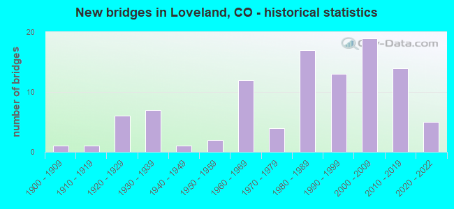
- New bridges - historical statistics
- 11900-1909
- 11910-1919
- 61920-1929
- 71930-1939
- 11940-1949
- 21950-1959
- 121960-1969
- 41970-1979
- 171980-1989
- 131990-1999
- 192000-2009
- 142010-2019
- 52020-2022
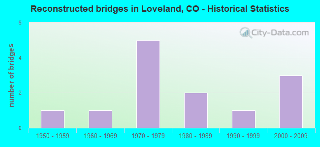
- Reconstructed bridges - Historical Statistics
- 11950-1959
- 11960-1969
- 51970-1979
- 21980-1989
- 11990-1999
- 32000-2009

- Bridge Condition - Deck
- 9.4%Very good
- 50.0%Good
- 29.7%Satisfactory
- 7.8%Fair
- 1.6%Poor
- 1.6%Serious
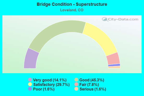
- Bridge Condition - Superstructure
- 14.1%Very good
- 45.3%Good
- 29.7%Satisfactory
- 7.8%Fair
- 1.6%Poor
- 1.6%Serious
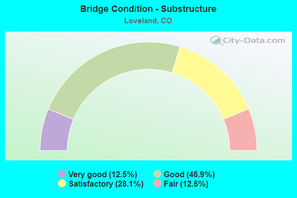
- Bridge Condition - Substructure
- 12.5%Very good
- 46.9%Good
- 28.1%Satisfactory
- 12.5%Fair
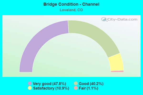
- Bridge Condition - Channel
- 47.8%Very good
- 40.2%Good
- 10.9%Satisfactory
- 1.1%Fair
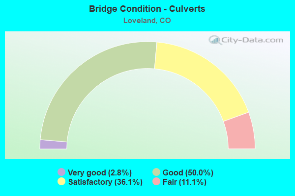
- Bridge Condition - Culverts
- 2.8%Very good
- 50.0%Good
- 36.1%Satisfactory
- 11.1%Fair
Find on map >> Show street view
Structure Number: LOV1200NAMAV, Location: 600 Ft S of US Hwy 34 (Lat: 40.405722, Lng: -105.121556), Route carried "on" structure: City street , Year Built: 1992, Status: Open, Structure Length: 1.05m (3.44ft), Average Daily Traffic: 6,851 (year 2021), Truck Traffic: 13%, Average Future Daily Traffic: 8,564 (year 2041), Design Load: HS 20, Features Intersected: Big Barnes Ditch, Facility Carried by Structure: Namaqua Avenue
Minimum Vertical Clearance: 30+ m (98+ ft), Kilometerpoint: 0.005, Lanes on structure: 2, Owner: City or Municipal Highway Agency, Approaching Roadway Width: 10.1m (33.1ft), Material/Design: Prestressed concrete, Design/Construction: Box Beam or Girders - Multiple, Number Of Spans In Main Unit: 1, Length of Maximum Span: 9.7m (31.8ft), Curb or Sidewalk Widths: Left: 1.2m (3.9ft), Right: 1.2m (3.9ft), Curb-To-Curb Width: 13.7m (44.9ft), Out-to-Out Width: 16.7m (54.8ft)
Condition: Deck: Good, Superstructure: Good, Substructure: Good, Channel: Very good, Operating Rating: 52.7 metric tons, Method Used To Determine Operating Rating: Load Factor (LF), Inventory Rating: 32.8 metric tons, Method Used To Determine Inventory Rating: Load Factor (LF), Structural Evaluation: Better than present minimum criteria, Deck Geometry: Superior to present desirable criteria, Waterway Adequacy: Equal to present desirable criteria, Approach Roadway Alignment: Equal to present desirable criteria, Designated Inspection Frequency: Every 24 months, Inspection Date: March 2021, Deck Structure Type: Other, Wearing Surface/Protective System: Wearing Surface: Bituminous, Membrane: Preformed Fabric, Deck Protection: Epoxy Coated Reinforcing
Find on map >> Show street view
Structure Number: LOV125W57THST, Location: W of Garfield Ave/SH287 (Lat: 40.451361, Lng: -105.077889), Route carried "on" structure: City street , Year Built: 2007, Status: Open, Structure Length: 0.85m (2.79ft), Average Daily Traffic: 14,302 (year 2021), Truck Traffic: 8%, Average Future Daily Traffic: 17,878 (year 2041), Features Intersected: Louden Ditch, Facility Carried by Structure: 57th Street
Minimum Vertical Clearance: 30+ m (98+ ft), Kilometerpoint: 0.317, Lanes on structure: 5, Owner: City or Municipal Highway Agency, Approaching Roadway Width: 27.6m (90.6ft), Skew: 20 degrees, Material/Design: Concrete, Design/Construction: Culvert, Length of Maximum Span: 8.5m (27.9ft), Curb-To-Curb Width: 29.1m (95.5ft), Out-to-Out Width: 69.0m (226.4ft)
Condition: Channel: Good, Culverts: Good, Operating Rating: 36.3 metric tons, Method Used To Determine Operating Rating: Field evaluation and documented engineering judgment, Inventory Rating: 32.7 metric tons, Method Used To Determine Inventory Rating: Field evaluation and documented engineering judgment, Structural Evaluation: Better than present minimum criteria, Deck Geometry: Superior to present desirable criteria, Waterway Adequacy: Equal to present desirable criteria, Approach Roadway Alignment: Equal to present desirable criteria, Designated Inspection Frequency: Every 24 months, Inspection Date: March 2021
Find on map >> Show street view
Structure Number: LOV1451HIGHPLNS, Location: 0.1 Mi N of US Hwy 34 (Lat: 40.409333, Lng: -104.964389), Route carried "on" structure: City street , Year Built: 1986, Status: Open, Structure Length: 1.55m (5.09ft), Average Daily Traffic: 330 (year 2021), Truck Traffic: 19%, Average Future Daily Traffic: 413 (year 2041), Features Intersected: Greeley Loveland Canal, Facility Carried by Structure: High Plains Road
Minimum Vertical Clearance: 30+ m (98+ ft), Kilometerpoint: 0.215, Lanes on structure: 2, Owner: City or Municipal Highway Agency, Approaching Roadway Width: 8.5m (27.9ft), Skew: 1 degrees, Material/Design: Prestressed concrete, Design/Construction: Tee Beam, Number Of Spans In Main Unit: 1, Length of Maximum Span: 13.8m (45.3ft), Curb-To-Curb Width: 9.1m (29.9ft), Out-to-Out Width: 9.9m (32.5ft)
Condition: Deck: Good, Superstructure: Good, Substructure: Good, Channel: Very good, Operating Rating: 61.3 metric tons, Method Used To Determine Operating Rating: Load Factor (LF), Inventory Rating: 34.8 metric tons, Method Used To Determine Inventory Rating: Load Factor (LF), Structural Evaluation: Better than present minimum criteria, Deck Geometry: Equal to present minimum criteria, Waterway Adequacy: Equal to present desirable criteria, Approach Roadway Alignment: Equal to present desirable criteria, Designated Inspection Frequency: Every 24 months, Inspection Date: March 2021, Deck Structure Type: Concrete Cast-file-Place, Wearing Surface/Protective System: Wearing Surface: Bituminous, Membrane: Built-up
Find on map >> Show street view
Structure Number: LOV1490FALRIVER, Location: 250 Ft. N of U.S. Hwy 34 (Lat: 40.407861, Lng: -105.007444), Route carried "on" structure: City street , Year Built: 1998, Year Reconstructed: 2000, Status: Open, Structure Length: 0.61m (2.00ft), Average Daily Traffic: 9,701 (year 2021), Truck Traffic: 7%, Average Future Daily Traffic: 12,126 (year 2041), Design Load: HS 20, Features Intersected: Farmers Indepen. Ditch, Facility Carried by Structure: Fall River Drive
Minimum Vertical Clearance: 30+ m (98+ ft), Kilometerpoint: 0.088, Lanes on structure: 3, Owner: City or Municipal Highway Agency, Approaching Roadway Width: 15.5m (50.9ft), Skew: 20 degrees, Material/Design: Concrete, Design/Construction: Culvert, Number Of Spans In Main Unit: 1, Length of Maximum Span: 6.1m (20.0ft), Curb or Sidewalk Widths: Left: 2.0m (6.6ft), Right: 3.3m (10.8ft), Curb-To-Curb Width: 15.3m (50.2ft), Out-to-Out Width: 20.2m (66.3ft)
Condition: Channel: Very good, Culverts: Good, Operating Rating: 43.8 metric tons, Method Used To Determine Operating Rating: Load Factor (LF), Inventory Rating: 26.2 metric tons, Method Used To Determine Inventory Rating: Load Factor (LF), Structural Evaluation: Equal to present minimum criteria, Deck Geometry: Equal to present minimum criteria, Waterway Adequacy: Equal to present desirable criteria, Approach Roadway Alignment: Equal to present desirable criteria, Designated Inspection Frequency: Every 24 months, Inspection Date: March 2021, Deck Structure Type: Concrete Cast-file-Place, Wearing Surface/Protective System: Wearing Surface: Bituminous
Find on map >> Show street view
Structure Number: LOV1490RKYMTAVA, Location: 220 Ft. N of U.S. Hwy 34 (Lat: 40.407861, Lng: -105.002444), Route carried "on" structure: City street , Year Built: 1994, Year Reconstructed: 2000, Status: Open, Structure Length: 0.66m (2.17ft), Average Daily Traffic: 24,030 (year 2021), Truck Traffic: 8%, Average Future Daily Traffic: 30,038 (year 2041), Design Load: HS 20, Features Intersected: Farmers Independent Ditc, Facility Carried by Structure: Rocky Mtn. Avenue
Minimum Vertical Clearance: 30+ m (98+ ft), Kilometerpoint: 0.087, Lanes on structure: 5, Owner: City or Municipal Highway Agency, Approaching Roadway Width: 28.0m (91.9ft), Skew: 20 degrees, Material/Design: Concrete, Design/Construction: Frame, Number Of Spans In Main Unit: 1, Length of Maximum Span: 6.2m (20.3ft), Curb or Sidewalk Widths: Left: 3.3m (10.8ft), Right: 2.9m (9.5ft), Curb-To-Curb Width: 27.1m (88.9ft), Out-to-Out Width: 36.5m (119.8ft)
Condition: Deck: Good, Superstructure: Good, Substructure: Good, Channel: Good, Operating Rating: 36.3 metric tons, Method Used To Determine Operating Rating: Field evaluation and documented engineering judgment, Inventory Rating: 30.7 metric tons, Method Used To Determine Inventory Rating: Load and Resistance Factor (LRFR), Structural Evaluation: Better than present minimum criteria, Deck Geometry: Superior to present desirable criteria, Waterway Adequacy: Equal to present desirable criteria, Approach Roadway Alignment: Equal to present desirable criteria, Designated Inspection Frequency: Every 24 months, Inspection Date: March 2021, Deck Structure Type: Concrete Cast-file-Place, Wearing Surface/Protective System: Wearing Surface: Bituminous
Find on map >> Show street view
Structure Number: LOV150MONROE AV, Location: 150 Ft N of First Street (Lat: 40.392861, Lng: -105.068722), Route carried "on" structure: City street , Year Built: 1922, Year Reconstructed: 1970, Status: Open, Structure Length: 1.04m (3.41ft), Average Daily Traffic: 505 (year 2021), Truck Traffic: 21%, Average Future Daily Traffic: 631 (year 2041), Features Intersected: Greeley Loveland Canal, Facility Carried by Structure: Monroe Avenue
Minimum Vertical Clearance: 30+ m (98+ ft), Kilometerpoint: 4.852, Lanes on structure: 2, Owner: City or Municipal Highway Agency, Approaching Roadway Width: 12.2m (40.0ft), Skew: 1 degrees, Material/Design: Concrete, Design/Construction: Tee Beam, Number Of Spans In Main Unit: 1, Length of Maximum Span: 9.1m (29.9ft), Curb or Sidewalk Widths: Left: 1.4m (4.6ft), Right: 1.4m (4.6ft), Curb-To-Curb Width: 9.8m (32.2ft), Out-to-Out Width: 13.0m (42.7ft)
Condition: Deck: Fair, Superstructure: Poor, Substructure: Fair, Channel: Good, Operating Rating: 36.3 metric tons, Method Used To Determine Operating Rating: Field evaluation and documented engineering judgment, Inventory Rating: 32.7 metric tons, Method Used To Determine Inventory Rating: Field evaluation and documented engineering judgment, Structural Evaluation: Meets minimum limits, Deck Geometry: Equal to present minimum criteria, Waterway Adequacy: Equal to present desirable criteria, Approach Roadway Alignment: Equal to present desirable criteria, Designated Inspection Frequency: Every 24 months, Inspection Date: March 2021, Deck Structure Type: Concrete Cast-file-Place, Wearing Surface/Protective System: Wearing Surface: Bituminous
Find on map >> Show street view
Structure Number: LOV150RAILRD AV, Location: 0.1 Mi N of East First St (Lat: 40.393194, Lng: -105.076222), Route carried "on" structure: City street , Year Built: 1917, Year Reconstructed: 1970, Status: Open, Structure Length: 1.28m (4.20ft), Average Daily Traffic: 926 (year 2021), Truck Traffic: 7%, Average Future Daily Traffic: 1,158 (year 2041), Features Intersected: Greeley Loveland Canal, Facility Carried by Structure: Railroad Avenue
Minimum Vertical Clearance: 30+ m (98+ ft), Kilometerpoint: 0.231, Lanes on structure: 2, Owner: City or Municipal Highway Agency, Approaching Roadway Width: 9.1m (29.9ft), Skew: 3 degrees, Material/Design: Concrete, Design/Construction: Tee Beam, Number Of Spans In Main Unit: 1, Length of Maximum Span: 11.2m (36.7ft), Curb or Sidewalk Widths: Left: 0.0m, Right: 1.6m (5.2ft), Curb-To-Curb Width: 10.0m (32.8ft), Out-to-Out Width: 12.5m (41.0ft)
Condition: Deck: Fair, Superstructure: Fair, Substructure: Fair, Channel: Satisfactory, Operating Rating: 36.3 metric tons, Method Used To Determine Operating Rating: Field evaluation and documented engineering judgment, Inventory Rating: 32.7 metric tons, Method Used To Determine Inventory Rating: Field evaluation and documented engineering judgment, Structural Evaluation: Somewhat better than minimum adequacy, Deck Geometry: Equal to present minimum criteria, Waterway Adequacy: Equal to present desirable criteria, Approach Roadway Alignment: Equal to present desirable criteria, Designated Inspection Frequency: Every 24 months, Inspection Date: March 2021, Deck Structure Type: Concrete Cast-file-Place, Wearing Surface/Protective System: Wearing Surface: Bituminous
Find on map >> Show street view
Structure Number: LOV150WASHTN AV, Location: 100 Ft N of 1st St (Lat: 40.393111, Lng: -105.070639), Route carried "on" structure: City street , Year Built: 1922, Year Reconstructed: 1970, Status: Open, Structure Length: 1.01m (3.31ft), Average Daily Traffic: 3,171 (year 2021), Truck Traffic: 9%, Average Future Daily Traffic: 3,964 (year 2041), Features Intersected: Greeley Loveland Canal, Facility Carried by Structure: Washington Avenue
Minimum Vertical Clearance: 30+ m (98+ ft), Kilometerpoint: 0.328, Lanes on structure: 2, Owner: City or Municipal Highway Agency, Approaching Roadway Width: 12.2m (40.0ft), Material/Design: Concrete, Design/Construction: Tee Beam, Number Of Spans In Main Unit: 1, Length of Maximum Span: 9.1m (29.9ft), Curb or Sidewalk Widths: Left: 1.5m (4.9ft), Right: 1.5m (4.9ft), Curb-To-Curb Width: 9.7m (31.8ft), Out-to-Out Width: 13.0m (42.7ft)
Condition: Deck: Satisfactory, Superstructure: Fair, Substructure: Satisfactory, Channel: Good, Operating Rating: 32.7 metric tons, Method Used To Determine Operating Rating: Field evaluation and documented engineering judgment, Inventory Rating: 24.5 metric tons, Method Used To Determine Inventory Rating: Field evaluation and documented engineering judgment, Structural Evaluation: Somewhat better than minimum adequacy, Deck Geometry: Meets minimum limits, Waterway Adequacy: Equal to present desirable criteria, Approach Roadway Alignment: Equal to present desirable criteria, Designated Inspection Frequency: Every 24 months, Inspection Date: April 2021, Deck Structure Type: Concrete Cast-file-Place, Wearing Surface/Protective System: Wearing Surface: Bituminous
Find on map >> Show street view
Structure Number: LOV1510DENVRAVE, Location: 0.1 Mi N of US Hwy 34 (Lat: 40.408778, Lng: -105.044778), Route carried "on" structure: City street , Year Built: 1985, Status: Open, Structure Length: 0.76m (2.49ft), Average Daily Traffic: 4,146 (year 2021), Truck Traffic: 3%, Average Future Daily Traffic: 5,183 (year 2041), Features Intersected: Greeley Loveland Canal, Facility Carried by Structure: Denver Avenue
Minimum Vertical Clearance: 30+ m (98+ ft), Kilometerpoint: 1.744, Lanes on structure: 2, Owner: City or Municipal Highway Agency, Approaching Roadway Width: 15.2m (49.9ft), Material/Design: Concrete, Design/Construction: Culvert, Number Of Spans In Main Unit: 2, Length of Maximum Span: 3.7m (12.1ft), Curb or Sidewalk Widths: Left: 1.1m (3.6ft), Right: 0.0m, Out-to-Out Width: 24.3m (79.7ft)
Condition: Channel: Very good, Culverts: Good, Operating Rating: 36.3 metric tons, Method Used To Determine Operating Rating: Field evaluation and documented engineering judgment, Inventory Rating: 32.7 metric tons, Method Used To Determine Inventory Rating: Field evaluation and documented engineering judgment, Structural Evaluation: Better than present minimum criteria, Waterway Adequacy: Equal to present desirable criteria, Approach Roadway Alignment: Equal to present desirable criteria, Designated Inspection Frequency: Every 24 months, Inspection Date: March 2021
Find on map >> Show street view
Structure Number: LOV1520CENTERRA, Location: 0.1 Mi N of US Hwy 34 (Lat: 40.407889, Lng: -104.983556), Route carried "on" structure: City street , Year Built: 2005, Status: Open, Structure Length: 1.01m (3.31ft), Average Daily Traffic: 20,179 (year 2021), Truck Traffic: 12%, Average Future Daily Traffic: 25,224 (year 2041), Design Load: HS 20, Features Intersected: Greeley Loveland Canal, Facility Carried by Structure: Centerra Parkway
Minimum Vertical Clearance: 30+ m (98+ ft), Kilometerpoint: 0.080, Lanes on structure: 9, Owner: City or Municipal Highway Agency, Approaching Roadway Width: 36.8m (120.7ft), Skew: 20 degrees, Material/Design: Concrete, Design/Construction: Culvert, Number Of Spans In Main Unit: 2, Length of Maximum Span: 4.9m (16.1ft), Curb or Sidewalk Widths: Left: 3.8m (12.5ft), Right: 3.4m (11.2ft), Curb-To-Curb Width: 44.7m (146.7ft), Out-to-Out Width: 53.1m (174.2ft)
Condition: Channel: Good, Culverts: Good, Operating Rating: 79.4 metric tons, Method Used To Determine Operating Rating: Load Factor (LF), Inventory Rating: 47.6 metric tons, Method Used To Determine Inventory Rating: Load Factor (LF), Structural Evaluation: Better than present minimum criteria, Deck Geometry: Superior to present desirable criteria, Waterway Adequacy: Equal to present desirable criteria, Approach Roadway Alignment: Equal to present desirable criteria, Designated Inspection Frequency: Every 24 months, Inspection Date: March 2021
Find on map >> Show street view
Structure Number: LOV1600NBYDLKAV, Location: 0.2 Mi N of U.S. Hwy 34 (Lat: 40.409889, Lng: -105.021111), Route carried "on" structure: City street , Year Built: 2019, Status: Open, Structure Length: 0.73m (2.40ft), Average Daily Traffic: 7,589 (year 2016), Truck Traffic: 9%, Average Future Daily Traffic: 11,915 (year 2036), Design Load: HL 93, Features Intersected: Greeley Loveland Canal, Facility Carried by Structure: N. Boyd Lake Ave
Minimum Vertical Clearance: 30+ m (98+ ft), Kilometerpoint: 0.000, Lanes on structure: 4, Owner: City or Municipal Highway Agency, Approaching Roadway Width: 21.0m (68.9ft), Skew: 20 degrees, Material/Design: Concrete, Design/Construction: Culvert, Number Of Spans In Main Unit: 1, Length of Maximum Span: 7.3m (24.0ft), Curb or Sidewalk Widths: Left: 3.5m (11.5ft), Right: 3.5m (11.5ft), Out-to-Out Width: 35.1m (115.2ft)
Condition: Channel: Very good, Culverts: Good, Operating Rating: 33.7 metric tons, Method Used To Determine Operating Rating: Load and Resistance Factor Rating (LRFR) rating reported by rating factor(RF) method using HL-93 loadings, Inventory Rating: 25.9 metric tons, Method Used To Determine Inventory Rating: Load and Resistance Factor Rating (LRFR) rating reported by rating factor(RF) method using HL-93 loadings, Structural Evaluation: Equal to present minimum criteria, Waterway Adequacy: Equal to present desirable criteria, Approach Roadway Alignment: Equal to present desirable criteria, Designated Inspection Frequency: Every 24 months, Inspection Date: March 2021
Find on map >> Show street view
Structure Number: LOV1760PARKDRIV, Location: 0.2 Mi E of Boise Avenue (Lat: 40.419139, Lng: -105.050389), Route carried "on" structure: City street , Year Built: 1993, Status: Open, Structure Length: 0.63m (2.07ft), Average Daily Traffic: 777 (year 2021), Truck Traffic: 10%, Average Future Daily Traffic: 971 (year 2041), Design Load: HS 20, Features Intersected: Westerdall Lake Outlet, Facility Carried by Structure: Park Drive
Minimum Vertical Clearance: 30+ m (98+ ft), Kilometerpoint: 0.529, Lanes on structure: 2, Owner: City or Municipal Highway Agency, Approaching Roadway Width: 11.3m (37.1ft), Material/Design: Concrete, Design/Construction: Culvert, Number Of Spans In Main Unit: 2, Length of Maximum Span: 3.0m (9.8ft), Curb or Sidewalk Widths: Left: 1.5m (4.9ft), Right: 1.5m (4.9ft), Curb-To-Curb Width: 12.1m (39.7ft), Out-to-Out Width: 15.6m (51.2ft)
Condition: Channel: Very good, Culverts: Good, Operating Rating: 68.8 metric tons, Method Used To Determine Operating Rating: Load Factor (LF), Inventory Rating: 41.2 metric tons, Method Used To Determine Inventory Rating: Load Factor (LF), Structural Evaluation: Better than present minimum criteria, Deck Geometry: Better than present minimum criteria, Waterway Adequacy: Equal to present desirable criteria, Approach Roadway Alignment: Equal to present desirable criteria, Designated Inspection Frequency: Every 24 months, Inspection Date: May 2021, Deck Structure Type: Concrete Cast-file-Place, Wearing Surface/Protective System: Wearing Surface: Bituminous, Membrane: Preformed Fabric, Deck Protection: Epoxy Coated Reinforcing
Find on map >> Show street view
Structure Number: LOV1804PNYRVRDR, Location: 0.1 Mi N of McWhinney Blv (Lat: 40.410528, Lng: -105.016972), Route carried "on" structure: City street , Year Built: 2000, Status: Open, Structure Length: 0.82m (2.69ft), Average Daily Traffic: 2,388 (year 2021), Truck Traffic: 1%, Average Future Daily Traffic: 2,985 (year 2041), Design Load: HS 20, Features Intersected: Greeley Loveland Canal, Facility Carried by Structure: Piney River Drive
Minimum Vertical Clearance: 30+ m (98+ ft), Kilometerpoint: 0.152, Lanes on structure: 2, Owner: City or Municipal Highway Agency, Approaching Roadway Width: 10.4m (34.1ft), Material/Design: Concrete, Design/Construction: Frame, Number Of Spans In Main Unit: 1, Length of Maximum Span: 7.3m (24.0ft), Curb or Sidewalk Widths: Left: 2.5m (8.2ft), Right: 2.5m (8.2ft), Curb-To-Curb Width: 11.5m (37.7ft), Out-to-Out Width: 17.7m (58.1ft)
Condition: Deck: Good, Superstructure: Good, Substructure: Good, Channel: Good, Operating Rating: 61.0 metric tons, Method Used To Determine Operating Rating: Load Factor (LF), Inventory Rating: 36.5 metric tons, Method Used To Determine Inventory Rating: Load Factor (LF), Structural Evaluation: Better than present minimum criteria, Deck Geometry: Somewhat better than minimum adequacy, Waterway Adequacy: Equal to present desirable criteria, Approach Roadway Alignment: Equal to present desirable criteria, Designated Inspection Frequency: Every 24 months, Inspection Date: March 2021, Deck Structure Type: Concrete Cast-file-Place, Wearing Surface/Protective System: Wearing Surface: Bituminous, Membrane: Built-up
Find on map >> Show street view
Structure Number: LOV180W.1ST ST, Location: 180 W First Street (Lat: 40.392778, Lng: -105.077500), Route carried "on" structure: City street , Year Built: 1984, Status: Open, Structure Length: 1.88m (6.17ft), Average Daily Traffic: 15,007 (year 2021), Truck Traffic: 10%, Average Future Daily Traffic: 18,759 (year 2041), Design Load: HS 20, Features Intersected: Greeley Loveland Canal, Facility Carried by Structure: West First Street
Minimum Vertical Clearance: 30+ m (98+ ft), Kilometerpoint: 4.112, Lanes on structure: 3, Owner: City or Municipal Highway Agency, Approaching Roadway Width: 14.6m (47.9ft), Skew: 5 degrees, Material/Design: Prestressed concrete, Design/Construction: Box Beam or Girders - Multiple, Number Of Spans In Main Unit: 1, Length of Maximum Span: 15.8m (51.8ft), Curb or Sidewalk Widths: Left: 1.8m (5.9ft), Right: 1.8m (5.9ft), Curb-To-Curb Width: 14.6m (47.9ft), Out-to-Out Width: 18.3m (60.0ft)
Condition: Deck: Serious, Superstructure: Serious, Substructure: Fair, Channel: Satisfactory, Operating Rating: 63.0 metric tons, Method Used To Determine Operating Rating: Load Factor (LF), Inventory Rating: 41.0 metric tons, Method Used To Determine Inventory Rating: Load Factor (LF), Structural Evaluation: High priority of corrective action, Deck Geometry: Somewhat better than minimum adequacy, Waterway Adequacy: Equal to present desirable criteria, Approach Roadway Alignment: Equal to present desirable criteria, Length Of Structure Improvement: 2.64m (8.66ft), Designated Inspection Frequency: Every 12 months, Inspection Date: March 2021, Bridge Improvement Cost: $2,513,000, Roadway Improvement Cost: $251,000, Total Project Cost: $2,764,000 ( Estimate for 2019), Deck Structure Type: Other, Wearing Surface/Protective System: Wearing Surface: Bituminous, Membrane: Built-up
Find on map >> Show street view
Structure Number: LOV1825W8THST-A, Location: 0.3 Mi W of Taft Avenue (Lat: 40.400944, Lng: -105.102592), Route carried "on" structure: City street , Year Built: 2020, Status: Open, Structure Length: 1.89m (6.20ft), Average Daily Traffic: 6,403 (year 2012), Truck Traffic: 9%, Average Future Daily Traffic: 10,052 (year 2032), Design Load: HL 93, Features Intersected: Big Barnes Ditch, Facility Carried by Structure: West 8th Street
Minimum Vertical Clearance: 30+ m (98+ ft), Kilometerpoint: 0.925, Lanes on structure: 2, Owner: City or Municipal Highway Agency, Approaching Roadway Width: 9.4m (30.8ft), Skew: 2 degrees, Material/Design: Prestressed concrete, Design/Construction: Box Beam or Girders - Single/Spread, Number Of Spans In Main Unit: 1, Length of Maximum Span: 17.2m (56.4ft), Curb or Sidewalk Widths: Left: 2.3m (7.5ft), Right: 2.3m (7.5ft), Curb-To-Curb Width: 10.4m (34.1ft), Out-to-Out Width: 14.9m (48.9ft)
Condition: Deck: Very good, Superstructure: Good, Substructure: Good, Channel: Very good, Operating Rating: 58.3 metric tons, Method Used To Determine Operating Rating: Load and Resistance Factor Rating (LRFR) rating reported by rating factor(RF) method using HL-93 loadings, Inventory Rating: 39.9 metric tons, Method Used To Determine Inventory Rating: Load and Resistance Factor Rating (LRFR) rating reported by rating factor(RF) method using HL-93 loadings, Structural Evaluation: Better than present minimum criteria, Deck Geometry: Meets minimum limits, Waterway Adequacy: Equal to present desirable criteria, Approach Roadway Alignment: Equal to present desirable criteria, Designated Inspection Frequency: Every 24 months, Inspection Date: June 2021, Deck Structure Type: Concrete Cast-file-Place, Wearing Surface/Protective System: Wearing Surface: Bituminous, Membrane: Preformed Fabric, Deck Protection: Epoxy Coated Reinforcing
Find on map >> Show street view
Structure Number: LOV2002RKYMTAV, Location: 0.2 mi N of McWhinney St (Lat: 40.414167, Lng: -105.002222), Route carried "on" structure: City street , Year Built: 2000, Status: Open, Structure Length: 0.80m (2.62ft), Average Daily Traffic: 16,493 (year 2021), Truck Traffic: 8%, Average Future Daily Traffic: 20,616 (year 2041), Design Load: HS 20, Features Intersected: Greeley Loveland Canal, Facility Carried by Structure: Rocky Mountain Ave
Minimum Vertical Clearance: 30+ m (98+ ft), Kilometerpoint: 0.813, Lanes on structure: 4, Owner: City or Municipal Highway Agency, Approaching Roadway Width: 21.3m (69.9ft), Skew: 2 degrees, Material/Design: Concrete, Design/Construction: Culvert, Number Of Spans In Main Unit: 1, Length of Maximum Span: 8.0m (26.2ft), Curb or Sidewalk Widths: Left: 3.8m (12.5ft), Right: 2.4m (7.9ft), Curb-To-Curb Width: 21.4m (70.2ft), Out-to-Out Width: 28.7m (94.2ft)
Condition: Channel: Very good, Culverts: Good, Inventory Rating: 65.4 metric tons, Method Used To Determine Inventory Rating: Load Factor (LF), Structural Evaluation: Better than present minimum criteria, Deck Geometry: Superior to present desirable criteria, Waterway Adequacy: Equal to present desirable criteria, Approach Roadway Alignment: Equal to present desirable criteria, Designated Inspection Frequency: Every 24 months, Inspection Date: March 2021, Wearing Surface/Protective System: Wearing Surface: Bituminous
Find on map >> Show street view
Structure Number: LOV200E37THST, Location: 0.1 Mi E. of Hwy 287 (Lat: 40.430231, Lng: -105.076064), Route carried "on" structure: City street , Year Built: 2021, Status: Open, Structure Length: 2.53m (8.30ft), Average Daily Traffic: 6,271 (year 2012), Truck Traffic: 4%, Average Future Daily Traffic: 9,845 (year 2032), Design Load: HL 93, Features Intersected: Dry Creek, Facility Carried by Structure: E. 37th Street
Minimum Vertical Clearance: 30+ m (98+ ft), Kilometerpoint: 1.707, Lanes on structure: 3, Owner: City or Municipal Highway Agency, Approaching Roadway Width: 15.3m (50.2ft), Skew: 1 degrees, Material/Design: Prestressed concrete, Design/Construction: Stringer/Multi-beam, Number Of Spans In Main Unit: 1, Length of Maximum Span: 22.8m (74.8ft), Curb or Sidewalk Widths: Left: 2.0m (6.6ft), Right: 2.0m (6.6ft), Curb-To-Curb Width: 15.3m (50.2ft), Out-to-Out Width: 20.1m (65.9ft)
Condition: Deck: Very good, Superstructure: Very good, Substructure: Very good, Channel: Very good, Operating Rating: 71.3 metric tons, Method Used To Determine Operating Rating: Load and Resistance Factor Rating (LRFR) rating reported by rating factor(RF) method using HL-93 loadings, Inventory Rating: 52.5 metric tons, Method Used To Determine Inventory Rating: Load and Resistance Factor Rating (LRFR) rating reported by rating factor(RF) method using HL-93 loadings, Structural Evaluation: Equal to present desirable criteria, Deck Geometry: Equal to present minimum criteria, Waterway Adequacy: Equal to present desirable criteria, Approach Roadway Alignment: Equal to present desirable criteria, Designated Inspection Frequency: Every 24 months, Inspection Date: January 2021, Deck Structure Type: Concrete Cast-file-Place, Wearing Surface/Protective System: Wearing Surface: Bituminous, Membrane: Built-up, Deck Protection: Epoxy Coated Reinforcing
Find on map >> Show street view
Structure Number: LOV2495W.1ST ST, Location: 20 Ft E of Lu Ann Drive (Lat: 40.392639, Lng: -105.111250), Route carried "on" structure: City street , Year Built: 1930, Year Reconstructed: 1997, Status: Open, Structure Length: 0.81m (2.66ft), Average Daily Traffic: 11,599 (year 2021), Truck Traffic: 16%, Average Future Daily Traffic: 14,499 (year 2041), Design Load: HS 20, Features Intersected: Transfer Ditch, Facility Carried by Structure: West 1st Street
Minimum Vertical Clearance: 30+ m (98+ ft), Kilometerpoint: 1.184, Lanes on structure: 3, Owner: City or Municipal Highway Agency, Approaching Roadway Width: 19.2m (63.0ft), Skew: 1 degrees, Material/Design: Concrete, Design/Construction: Culvert, Number Of Spans In Main Unit: 3, Length of Maximum Span: 2.5m (8.2ft), Curb or Sidewalk Widths: Left: 0.0m, Right: 1.8m (5.9ft), Curb-To-Curb Width: 26.0m (85.3ft), Out-to-Out Width: 31.3m (102.7ft)
Condition: Channel: Good, Culverts: Satisfactory, Operating Rating: 36.3 metric tons, Method Used To Determine Operating Rating: Field evaluation and documented engineering judgment, Inventory Rating: 32.7 metric tons, Method Used To Determine Inventory Rating: Field evaluation and documented engineering judgment, Structural Evaluation: Equal to present minimum criteria, Deck Geometry: Superior to present desirable criteria, Waterway Adequacy: Equal to present desirable criteria, Approach Roadway Alignment: Equal to present desirable criteria, Designated Inspection Frequency: Every 24 months, Inspection Date: March 2021
Find on map >> Show street view
Structure Number: LOV2888CENTERRA, Location: 1.2 MI N OF KENDALL ST (Lat: 40.421222, Lng: -104.984389), Route carried "on" structure: City street , Year Built: 2007, Status: Open, Structure Length: 0.72m (2.36ft), Average Daily Traffic: 12,552 (year 2021), Truck Traffic: 8%, Average Future Daily Traffic: 15,690 (year 2041), Design Load: HS 20, Features Intersected: Future Bike Trail, Facility Carried by Structure: CENTERRA PKWY
Minimum Vertical Clearance: 30+ m (98+ ft), Kilometerpoint: 1.735, Lanes on structure: 4, Owner: City or Municipal Highway Agency, Approaching Roadway Width: 26.5m (86.9ft), Skew: 32 degrees, Material/Design: Concrete, Design/Construction: Culvert, Number Of Spans In Main Unit: 1, Length of Maximum Span: 7.2m (23.6ft), Curb-To-Curb Width: 26.5m (86.9ft), Out-to-Out Width: 45.1m (148.0ft)
Condition: Culverts: Good, Inventory Rating: 91.8 metric tons, Method Used To Determine Inventory Rating: Load Factor (LF), Structural Evaluation: Better than present minimum criteria, Deck Geometry: Superior to present desirable criteria, Approach Roadway Alignment: Equal to present desirable criteria, Designated Inspection Frequency: Every 24 months, Inspection Date: March 2021
Find on map >> Show street view
Structure Number: LOV3190SW14THST, Location: 600 FT W of Katie Ave (Lat: 40.378414, Lng: -105.121378), Route carried "on" structure: City street , Year Built: 1901, Status: Open, Structure Length: 0.67m (2.20ft), Average Daily Traffic: 9,793 (year 2021), Truck Traffic: 15%, Average Future Daily Traffic: 12,241 (year 2041), Features Intersected: Misc Drainage Basin, Facility Carried by Structure: SW 14th Street
Minimum Vertical Clearance: 30+ m (98+ ft), Kilometerpoint: 1.157, Lanes on structure: 3, Owner: City or Municipal Highway Agency, Approaching Roadway Width: 15.8m (51.8ft), Material/Design: Concrete, Design/Construction: Culvert, Number Of Spans In Main Unit: 4, Length of Maximum Span: 1.3m (4.3ft), Out-to-Out Width: 30.0m (98.4ft)
Condition: Channel: Good, Culverts: Good, Operating Rating: 36.3 metric tons, Method Used To Determine Operating Rating: Field evaluation and documented engineering judgment, Inventory Rating: 32.7 metric tons, Method Used To Determine Inventory Rating: Field evaluation and documented engineering judgment, Structural Evaluation: Better than present minimum criteria, Waterway Adequacy: Equal to present desirable criteria, Approach Roadway Alignment: Equal to present desirable criteria, Designated Inspection Frequency: Every 24 months, Inspection Date: June 2021
Find on map >> Show street view
Structure Number: LOV425W.29TH ST, Location: 425 W 29th Street (Lat: 40.421778, Lng: -105.082389), Route carried "on" structure: City street , Year Built: 1925, Year Reconstructed: 1985, Status: Open, Structure Length: 0.87m (2.85ft), Average Daily Traffic: 21,602 (year 2021), Truck Traffic: 5%, Average Future Daily Traffic: 27,003 (year 2041), Design Load: HS 20, Features Intersected: L. Loveland Outlet Canal, Facility Carried by Structure: West 29th Street
Minimum Vertical Clearance: 30+ m (98+ ft), Kilometerpoint: 3.360, Lanes on structure: 4, Owner: City or Municipal Highway Agency, Approaching Roadway Width: 18.0m (59.1ft), Skew: 3 degrees, Material/Design: Prestressed concrete, Design/Construction: Tee Beam, Number Of Spans In Main Unit: 1, Length of Maximum Span: 7.1m (23.3ft), Curb or Sidewalk Widths: Left: 2.4m (7.9ft), Right: 2.4m (7.9ft), Curb-To-Curb Width: 17.8m (58.4ft), Out-to-Out Width: 23.0m (75.5ft)
Condition: Deck: Satisfactory, Superstructure: Satisfactory, Substructure: Fair, Channel: Good, Operating Rating: 36.3 metric tons, Method Used To Determine Operating Rating: Field evaluation and documented engineering judgment, Inventory Rating: 32.7 metric tons, Method Used To Determine Inventory Rating: Field evaluation and documented engineering judgment, Structural Evaluation: Somewhat better than minimum adequacy, Deck Geometry: Somewhat better than minimum adequacy, Waterway Adequacy: Equal to present desirable criteria, Approach Roadway Alignment: Equal to present desirable criteria, Designated Inspection Frequency: Every 24 months, Inspection Date: June 2021, Deck Structure Type: Other, Wearing Surface/Protective System: Wearing Surface: Bituminous
Find on map >> Show street view
Structure Number: LOV450SRAILRDAV, Location: 450 S Railroad Avenue (Lat: 40.388917, Lng: -105.079000), Route carried "on" structure: City street , Year Built: 1990, Status: Open, Structure Length: 3.29m (10.79ft), Average Daily Traffic: 2,596 (year 2021), Truck Traffic: 11%, Average Future Daily Traffic: 3,245 (year 2041), Design Load: HS 20, Features Intersected: Big Thompson River, Facility Carried by Structure: Railroad Avenue
Minimum Vertical Clearance: 30+ m (98+ ft), Kilometerpoint: 0.061, Lanes on structure: 2, Owner: City or Municipal Highway Agency, Approaching Roadway Width: 12.2m (40.0ft), Material/Design: Prestressed concrete, Design/Construction: Box Beam or Girders - Multiple, Number Of Spans In Main Unit: 1, Length of Maximum Span: 31.3m (102.7ft), Curb or Sidewalk Widths: Left: 1.5m (4.9ft), Right: 1.5m (4.9ft), Curb-To-Curb Width: 12.8m (42.0ft), Out-to-Out Width: 16.5m (54.1ft)
Condition: Deck: Good, Superstructure: Good, Substructure: Good, Channel: Good, Operating Rating: 67.3 metric tons, Method Used To Determine Operating Rating: Load Factor (LF), Inventory Rating: 40.4 metric tons, Method Used To Determine Inventory Rating: Load Factor (LF), Structural Evaluation: Better than present minimum criteria, Deck Geometry: Equal to present minimum criteria, Waterway Adequacy: Better than present minimum criteria, Approach Roadway Alignment: Equal to present desirable criteria, Designated Inspection Frequency: Every 24 months, Inspection Date: May 2021, Deck Structure Type: Concrete Cast-file-Place, Wearing Surface/Protective System: Wearing Surface: Bituminous, Membrane: Preformed Fabric
Find on map >> Show street view
Structure Number: LOV5040CLEARWTR, Location: N. of Valley Oak Dr. (Lat: 40.444028, Lng: -105.021806), Route carried "on" structure: City street , Year Built: 2007, Status: Open, Structure Length: 0.67m (2.20ft), Average Daily Traffic: 922 (year 2021), Truck Traffic: 17%, Average Future Daily Traffic: 1,153 (year 2041), Features Intersected: Local Drainage, Facility Carried by Structure: Clearwater Drive
Minimum Vertical Clearance: 30+ m (98+ ft), Kilometerpoint: 0.081, Lanes on structure: 2, Owner: City or Municipal Highway Agency, Approaching Roadway Width: 13.4m (44.0ft), Material/Design: Concrete, Design/Construction: Culvert, Number Of Spans In Main Unit: 2, Length of Maximum Span: 3.0m (9.8ft), Curb or Sidewalk Widths: Left: 1.4m (4.6ft), Right: 1.4m (4.6ft), Out-to-Out Width: 21.1m (69.2ft)
Condition: Channel: Good, Culverts: Satisfactory, Operating Rating: 56.1 metric tons, Method Used To Determine Operating Rating: Load Factor (LF), Inventory Rating: 33.7 metric tons, Method Used To Determine Inventory Rating: Load Factor (LF), Structural Evaluation: Equal to present minimum criteria, Waterway Adequacy: Equal to present desirable criteria, Approach Roadway Alignment: Equal to present desirable criteria, Designated Inspection Frequency: Every 24 months, Inspection Date: May 2021
Find on map >> Show street view
Structure Number: LOV5400CEDARVDR, Location: 0.2 Mi W of Rossum Drive (Lat: 40.401389, Lng: -105.151028), Route carried "on" structure: City street , Year Built: 1998, Status: Open, Structure Length: 1.58m (5.18ft), Average Daily Traffic: 516 (year 2021), Truck Traffic: 13%, Average Future Daily Traffic: 645 (year 2041), Design Load: HS 20, Features Intersected: Dry Creek, Facility Carried by Structure: Cedar Valley Drive
Minimum Vertical Clearance: 30+ m (98+ ft), Kilometerpoint: 0.233, Lanes on structure: 2, Owner: City or Municipal Highway Agency, Approaching Roadway Width: 11.0m (36.1ft), Material/Design: Prestressed concrete, Design/Construction: Tee Beam, Number Of Spans In Main Unit: 1, Length of Maximum Span: 14.6m (47.9ft), Curb or Sidewalk Widths: Left: 1.2m (3.9ft), Right: 1.2m (3.9ft), Curb-To-Curb Width: 11.0m (36.1ft), Out-to-Out Width: 14.3m (46.9ft)
Condition: Deck: Good, Superstructure: Good, Substructure: Good, Channel: Satisfactory, Operating Rating: 54.8 metric tons, Method Used To Determine Operating Rating: Load Factor (LF), Inventory Rating: 29.8 metric tons, Method Used To Determine Inventory Rating: Load Factor (LF), Structural Evaluation: Better than present minimum criteria, Deck Geometry: Better than present minimum criteria, Waterway Adequacy: Equal to present desirable criteria, Approach Roadway Alignment: Equal to present desirable criteria, Designated Inspection Frequency: Every 24 months, Inspection Date: May 2021, Deck Structure Type: Other, Wearing Surface/Protective System: Wearing Surface: Bituminous, Membrane: Built-up, Deck Protection: Epoxy Coated Reinforcing
Find on map >> Show street view
Structure Number: LOV6090SKYPOND, Location: 0.1 Mi W of Centerra Pkwy (Lat: 40.411111, Lng: -104.987111), Route carried "on" structure: City street , Year Built: 2005, Status: Open, Structure Length: 1.02m (3.35ft), Average Daily Traffic: 7,236 (year 2021), Truck Traffic: 2%, Average Future Daily Traffic: 9,045 (year 2041), Design Load: HS 20, Features Intersected: Greeley Loveland Canal, Facility Carried by Structure: Sky Pond Drive
Minimum Vertical Clearance: 30+ m (98+ ft), Kilometerpoint: 0.431, Lanes on structure: 5, Owner: City or Municipal Highway Agency, Approaching Roadway Width: 24.3m (79.7ft), Skew: 21 degrees, Material/Design: Concrete, Design/Construction: Culvert, Number Of Spans In Main Unit: 2, Length of Maximum Span: 5.0m (16.4ft), Curb or Sidewalk Widths: Left: 3.1m (10.2ft), Right: 3.1m (10.2ft), Curb-To-Curb Width: 26.8m (87.9ft), Out-to-Out Width: 46.0m (150.9ft)
Condition: Channel: Good, Culverts: Good, Operating Rating: 86.5 metric tons, Method Used To Determine Operating Rating: Load Factor (LF), Inventory Rating: 51.9 metric tons, Method Used To Determine Inventory Rating: Load Factor (LF), Structural Evaluation: Better than present minimum criteria, Deck Geometry: Superior to present desirable criteria, Waterway Adequacy: Equal to present desirable criteria, Approach Roadway Alignment: Equal to present desirable criteria, Designated Inspection Frequency: Every 24 months, Inspection Date: March 2021
Find on map >> Show street view
Structure Number: LOV640NWILAVE-A, Location: 0.45 Mi N of W. 1st St. (Lat: 40.397917, Lng: -105.111028), Route carried "on" structure: City street , Year Built: 1999, Status: Open, Structure Length: 4.96m (16.27ft), Average Daily Traffic: 14,906 (year 2021), Truck Traffic: 17%, Average Future Daily Traffic: 18,633 (year 2041), Design Load: HS 20, Features Intersected: Big Thompson River, Facility Carried by Structure: N. Wilson Avenue
Minimum Vertical Clearance: 30+ m (98+ ft), Kilometerpoint: 2.466, Lanes on structure: 4, Owner: City or Municipal Highway Agency, Approaching Roadway Width: 18.3m (60.0ft), Skew: 1 degrees, Material/Design: Prestressed concrete continuous, Design/Construction: Box Beam or Girders - Single/Spread, Number Of Spans In Main Unit: 2, Length of Maximum Span: 23.4m (76.8ft), Curb or Sidewalk Widths: Left: 0.0m, Right: 3.0m (9.8ft), Curb-To-Curb Width: 16.5m (54.1ft), Out-to-Out Width: 20.3m (66.6ft)
Condition: Deck: Good, Superstructure: Very good, Substructure: Good, Channel: Good, Inventory Rating: 51.5 metric tons, Method Used To Determine Inventory Rating: Load Factor (LF), Structural Evaluation: Better than present minimum criteria, Deck Geometry: Meets minimum limits, Waterway Adequacy: Equal to present desirable criteria, Approach Roadway Alignment: Equal to present desirable criteria, Designated Inspection Frequency: Every 24 months, Inspection Date: May 2021, Deck Structure Type: Concrete Cast-file-Place, Wearing Surface/Protective System: Wearing Surface: Bituminous, Membrane: Built-up
Find on map >> Show street view
Structure Number: LOV660W.1ST ST, Location: 50 Ft W of Franklin Ave. (Lat: 40.392861, Lng: -105.086889), Route carried "on" structure: City street , Year Built: 1988, Status: Open, Structure Length: 0.99m (3.25ft), Average Daily Traffic: 16,874 (year 2021), Truck Traffic: 11%, Average Future Daily Traffic: 21,093 (year 2041), Design Load: HS 20, Features Intersected: Greeley Loveland Canal, Facility Carried by Structure: West 1st Street
Minimum Vertical Clearance: 30+ m (98+ ft), Kilometerpoint: 3.275, Lanes on structure: 3, Owner: City or Municipal Highway Agency, Approaching Roadway Width: 14.0m (45.9ft), Skew: 4 degrees, Material/Design: Concrete, Design/Construction: Frame, Number Of Spans In Main Unit: 1, Length of Maximum Span: 8.6m (28.2ft), Curb or Sidewalk Widths: Left: 1.9m (6.2ft), Right: 1.9m (6.2ft), Curb-To-Curb Width: 15.3m (50.2ft), Out-to-Out Width: 24.2m (79.4ft)
Condition: Deck: Fair, Superstructure: Fair, Substructure: Satisfactory, Channel: Good, Operating Rating: 54.1 metric tons, Method Used To Determine Operating Rating: Load Factor (LF), Inventory Rating: 32.6 metric tons, Method Used To Determine Inventory Rating: Load Factor (LF), Structural Evaluation: Somewhat better than minimum adequacy, Deck Geometry: Equal to present minimum criteria, Waterway Adequacy: Equal to present desirable criteria, Approach Roadway Alignment: Equal to present desirable criteria, Designated Inspection Frequency: Every 24 months, Inspection Date: March 2021, Deck Structure Type: Other, Wearing Surface/Protective System: Wearing Surface: Bituminous, Membrane: Preformed Fabric
Find on map >> Show street view
Structure Number: LOV696DEERMEADW, Location: .7 MI W of Rossum Drive (Lat: 40.396389, Lng: -105.158333), Route carried "on" structure: City street , Year Built: 2008, Status: Open, Structure Length: 5.53m (18.14ft), Average Daily Traffic: 71 (year 2021), Truck Traffic: 26%, Average Future Daily Traffic: 89 (year 2041), Design Load: HS 25 or greater, Features Intersected: Dry Creek, Facility Carried by Structure: Deer Meadow Drive
Minimum Vertical Clearance: 30+ m (98+ ft), Kilometerpoint: 1.120, Lanes on structure: 2, Owner: City or Municipal Highway Agency, Approaching Roadway Width: 10.4m (34.1ft), Material/Design: Prestressed concrete continuous, Design/Construction: Stringer/Multi-beam, Number Of Spans In Main Unit: 3, Length of Maximum Span: 17.3m (56.8ft), Curb or Sidewalk Widths: Left: 1.5m (4.9ft), Right: 1.5m (4.9ft), Curb-To-Curb Width: 7.3m (24.0ft), Out-to-Out Width: 11.1m (36.4ft)
Condition: Deck: Good, Superstructure: Good, Substructure: Good, Channel: Good, Operating Rating: 29.1 metric tons, Method Used To Determine Operating Rating: Load Factor (LF), Inventory Rating: 17.4 metric tons, Method Used To Determine Inventory Rating: Load Factor (LF), Structural Evaluation: Somewhat better than minimum adequacy, Deck Geometry: Equal to present minimum criteria, Waterway Adequacy: Equal to present desirable criteria, Approach Roadway Alignment: Equal to present desirable criteria, Designated Inspection Frequency: Every 24 months, Inspection Date: May 2021, Deck Structure Type: Concrete Cast-file-Place, Wearing Surface/Protective System: Wearing Surface: Bituminous, Membrane: Built-up, Deck Protection: Epoxy Coated Reinforcing
Find on map >> Show street view
Structure Number: LOV720SRAILRDAV, Location: 0.6 mi N of CR 18 (Lat: 40.385575, Lng: -105.082244), Route carried "on" structure: City street , Year Built: 2019, Status: Open, Structure Length: 3.14m (10.30ft), Average Daily Traffic: 2,312 (year 2021), Truck Traffic: 7%, Average Future Daily Traffic: 2,890 (year 2041), Design Load: HL 93, Features Intersected: Flood plain, Facility Carried by Structure: S Railroad Ave
Minimum Vertical Clearance: 30+ m (98+ ft), Kilometerpoint: 0.002, Lanes on structure: 2, Owner: City or Municipal Highway Agency, Approaching Roadway Width: 11.6m (38.1ft), Skew: 2 degrees, Material/Design: Prestressed concrete, Design/Construction: Stringer/Multi-beam, Number Of Spans In Main Unit: 1, Length of Maximum Span: 29.6m (97.1ft), Curb or Sidewalk Widths: Left: 1.5m (4.9ft), Right: 1.5m (4.9ft), Curb-To-Curb Width: 11.6m (38.1ft), Out-to-Out Width: 15.2m (49.9ft)
Condition: Deck: Good, Superstructure: Good, Substructure: Very good, Channel: Very good, Operating Rating: 48.6 metric tons, Method Used To Determine Operating Rating: Load and Resistance Factor Rating (LRFR) rating reported by rating factor(RF) method using HL-93 loadings, Inventory Rating: 35.3 metric tons, Method Used To Determine Inventory Rating: Load and Resistance Factor Rating (LRFR) rating reported by rating factor(RF) method using HL-93 loadings, Structural Evaluation: Better than present minimum criteria, Deck Geometry: Somewhat better than minimum adequacy, Waterway Adequacy: Equal to present desirable criteria, Approach Roadway Alignment: Equal to present desirable criteria, Designated Inspection Frequency: Every 24 months, Inspection Date: May 2021, Deck Structure Type: Concrete Precast Panels, Wearing Surface/Protective System: Wearing Surface: Bituminous, Deck Protection: Epoxy Coated Reinforcing
Find on map >> Show street view
Structure Number: LOV830E.4TH ST, Location: 0.1 MI W of St. Louis AV (Lat: 40.395389, Lng: -105.065778), Route carried "on" structure: City street , Year Built: 1921, Status: Open, Structure Length: 1.04m (3.41ft), Average Daily Traffic: 2,946 (year 2021), Truck Traffic: 11%, Average Future Daily Traffic: 3,683 (year 2041), Features Intersected: Greeley Loveland Canal, Facility Carried by Structure: East 4th Street
Minimum Vertical Clearance: 30+ m (98+ ft), Kilometerpoint: 2.060, Lanes on structure: 2, Owner: City or Municipal Highway Agency, Approaching Roadway Width: 13.4m (44.0ft), Material/Design: Concrete, Design/Construction: Tee Beam, Number Of Spans In Main Unit: 1, Length of Maximum Span: 9.1m (29.9ft), Curb-To-Curb Width: 8.6m (28.2ft), Out-to-Out Width: 9.2m (30.2ft)
Condition: Deck: Satisfactory, Superstructure: Fair, Substructure: Fair, Channel: Good, Operating Rating: 36.3 metric tons, Method Used To Determine Operating Rating: Field evaluation and documented engineering judgment, Inventory Rating: 32.7 metric tons, Method Used To Determine Inventory Rating: Field evaluation and documented engineering judgment, Structural Evaluation: Somewhat better than minimum adequacy, Deck Geometry: Meets minimum limits, Waterway Adequacy: Equal to present desirable criteria, Approach Roadway Alignment: Equal to present desirable criteria, Designated Inspection Frequency: Every 24 months, Inspection Date: March 2021, Deck Structure Type: Other, Wearing Surface/Protective System: Wearing Surface: Bituminous
Find on map >> Show street view
Structure Number: LOV850MADAV-A, Location: 0.5 Mi N of East 1st St (Lat: 40.400556, Lng: -105.058889), Route carried "on" structure: City street , Year Built: 2015, Status: Open, Structure Length: 1.51m (4.95ft), Average Daily Traffic: 12,136 (year 2021), Truck Traffic: 7%, Average Future Daily Traffic: 15,170 (year 2041), Features Intersected: Greeley Loveland Canal, Facility Carried by Structure: North Madison Ave
Minimum Vertical Clearance: 30+ m (98+ ft), Kilometerpoint: 1.904, Lanes on structure: 2, Owner: City or Municipal Highway Agency, Approaching Roadway Width: 12.4m (40.7ft), Skew: 4 degrees, Material/Design: Concrete, Design/Construction: Culvert, Number Of Spans In Main Unit: 2, Length of Maximum Span: 8.2m (26.9ft), Curb or Sidewalk Widths: Left: 2.6m (8.5ft), Right: 2.6m (8.5ft), Curb-To-Curb Width: 15.2m (49.9ft), Out-to-Out Width: 21.3m (69.9ft)
Condition: Channel: Very good, Culverts: Good, Operating Rating: 81.6 metric tons, Method Used To Determine Operating Rating: Load and Resistance Factor Rating (LRFR) rating reported by rating factor(RF) method using HL-93 loadings, Inventory Rating: 62.9 metric tons, Method Used To Determine Inventory Rating: Load and Resistance Factor Rating (LRFR) rating reported by rating factor(RF) method using HL-93 loadings, Structural Evaluation: Better than present minimum criteria, Deck Geometry: Superior to present desirable criteria, Waterway Adequacy: Equal to present desirable criteria, Approach Roadway Alignment: Equal to present desirable criteria, Designated Inspection Frequency: Every 24 months, Inspection Date: June 2021, Deck Structure Type: Concrete Cast-file-Place, Wearing Surface/Protective System: Wearing Surface: Bituminous, Membrane: Preformed Fabric, Deck Protection: Epoxy Coated Reinforcing
Find on map >> Show street view
Structure Number: LOV899SOCTYRD9E, Location: 0.4 Mi N of St Hwy 402 (Lat: 40.383139, Lng: -105.030056), Route carried "on" structure: City street , Year Built: 1988, Status: Open, Structure Length: 3.98m (13.06ft), Average Daily Traffic: 6,505 (year 2021), Truck Traffic: 15%, Average Future Daily Traffic: 8,131 (year 2041), Design Load: HS 20, Features Intersected: Big Thompson River, Facility Carried by Structure: County Road 9E
Minimum Vertical Clearance: 30+ m (98+ ft), Kilometerpoint: 0.564, Lanes on structure: 2, Owner: City or Municipal Highway Agency, Approaching Roadway Width: 11.0m (36.1ft), Material/Design: Prestressed concrete, Design/Construction: Stringer/Multi-beam, Number Of Spans In Main Unit: 1, Length of Maximum Span: 38.3m (125.7ft), Curb-To-Curb Width: 11.0m (36.1ft), Out-to-Out Width: 11.7m (38.4ft)
Condition: Deck: Good, Superstructure: Very good, Substructure: Good, Channel: Very good, Operating Rating: 61.1 metric tons, Method Used To Determine Operating Rating: Load Factor (LF), Inventory Rating: 36.7 metric tons, Method Used To Determine Inventory Rating: Load Factor (LF), Structural Evaluation: Better than present minimum criteria, Deck Geometry: Meets minimum limits, Waterway Adequacy: Better than present minimum criteria, Approach Roadway Alignment: Equal to present desirable criteria, Designated Inspection Frequency: Every 24 months, Inspection Date: May 2021, Deck Structure Type: Concrete Cast-file-Place, Wearing Surface/Protective System: Wearing Surface: Bituminous, Membrane: Preformed Fabric, Deck Protection: Epoxy Coated Reinforcing
Find on map >> Show street view
Structure Number: LOV990NWILAVE, Location: 0.8 Mi N of West First St (Lat: 40.402278, Lng: -105.110722), Route carried "on" structure: City street , Year Built: 2001, Status: Open, Structure Length: 1.41m (4.63ft), Average Daily Traffic: 14,943 (year 2021), Truck Traffic: 19%, Average Future Daily Traffic: 18,679 (year 2041), Design Load: HS 20, Features Intersected: Big Barnes Ditch, Facility Carried by Structure: Wilson Avenue
Minimum Vertical Clearance: 30+ m (98+ ft), Kilometerpoint: 3.023, Lanes on structure: 4, Owner: City or Municipal Highway Agency, Approaching Roadway Width: 19.5m (64.0ft), Skew: 31 degrees, Material/Design: Prestressed concrete, Design/Construction: Box Beam or Girders - Multiple, Number Of Spans In Main Unit: 1, Length of Maximum Span: 12.6m (41.3ft), Curb or Sidewalk Widths: Left: 3.0m (9.8ft), Right: 2.4m (7.9ft), Curb-To-Curb Width: 19.5m (64.0ft), Out-to-Out Width: 27.4m (89.9ft)
Condition: Deck: Good, Superstructure: Good, Substructure: Good, Channel: Good, Inventory Rating: 51.5 metric tons, Method Used To Determine Inventory Rating: Load Factor (LF), Structural Evaluation: Better than present minimum criteria, Deck Geometry: Better than present minimum criteria, Waterway Adequacy: Equal to present desirable criteria, Approach Roadway Alignment: Equal to present desirable criteria, Designated Inspection Frequency: Every 24 months, Inspection Date: March 2021, Deck Structure Type: Concrete Cast-file-Place, Wearing Surface/Protective System: Wearing Surface: Bituminous, Membrane: Preformed Fabric
Find on map >> Show street view
Structure Number: LR11C-0.7-24E-A, Location: 1 Mi S of Co Rd 24E (Lat: 40.438611, Lng: -105.045278), Route carried "on" structure: County highway , Year Built: 2015, Status: Open, Structure Length: 1.33m (4.36ft), Average Daily Traffic: 9,828 (year 2021), Truck Traffic: 27%, Average Future Daily Traffic: 12,285 (year 2041), Design Load: HL 93, Features Intersected: Boyd/Horseshoe Canal, Facility Carried by Structure: County Road 11C
Minimum Vertical Clearance: 30+ m (98+ ft), Kilometerpoint: 1.109, Lanes on structure: 2, Owner: County Highway Agency, Approaching Roadway Width: 11.0m (36.1ft), Material/Design: Concrete, Design/Construction: Culvert, Number Of Spans In Main Unit: 3, Length of Maximum Span: 4.3m (14.1ft), Curb-To-Curb Width: 11.0m (36.1ft), Out-to-Out Width: 11.9m (39.0ft)
Condition: Channel: Very good, Culverts: Good, Operating Rating: 74.5 metric tons, Method Used To Determine Operating Rating: Load and Resistance Factor Rating (LRFR) rating reported by rating factor(RF) method using HL-93 loadings, Inventory Rating: 58.3 metric tons, Method Used To Determine Inventory Rating: Load and Resistance Factor Rating (LRFR) rating reported by rating factor(RF) method using HL-93 loadings, Structural Evaluation: Better than present minimum criteria, Deck Geometry: Meets minimum limits, Waterway Adequacy: Equal to present desirable criteria, Approach Roadway Alignment: Equal to present desirable criteria, Designated Inspection Frequency: Every 24 months, Inspection Date: June 2021
Find on map >> Show street view
Structure Number: LR11H-0.3-S402, Location: 0.3 Mi N of St Hwy 402 (Lat: 40.383056, Lng: -105.054361), Route carried "on" structure: County highway , Year Built: 1966, Status: Open, Structure Length: 2.22m (7.28ft), Average Daily Traffic: 10,768 (year 2021), Truck Traffic: 7%, Average Future Daily Traffic: 13,460 (year 2041), Design Load: HS 20, Features Intersected: Big Thompson River, Facility Carried by Structure: County Road 11H
Minimum Vertical Clearance: 30+ m (98+ ft), Kilometerpoint: 0.525, Lanes on structure: 2, Owner: County Highway Agency, Approaching Roadway Width: 7.6m (24.9ft), Skew: 2 degrees, Material/Design: Prestressed concrete, Design/Construction: Tee Beam, Number Of Spans In Main Unit: 1, Length of Maximum Span: 21.1m (69.2ft), Curb or Sidewalk Widths: Left: 0.2m (0.7ft), Right: 0.2m (0.7ft), Curb-To-Curb Width: 6.9m (22.6ft), Out-to-Out Width: 7.3m (24.0ft)
Condition: Deck: Fair, Superstructure: Satisfactory, Substructure: Fair, Channel: Very good, Operating Rating: 36.3 metric tons, Method Used To Determine Operating Rating: Field evaluation and documented engineering judgment, Inventory Rating: 32.7 metric tons, Method Used To Determine Inventory Rating: Field evaluation and documented engineering judgment, Structural Evaluation: Somewhat better than minimum adequacy, Deck Geometry: High priority of replacement, Waterway Adequacy: Better than present minimum criteria, Approach Roadway Alignment: Equal to present minimum criteria, Length Of Structure Improvement: 2.22m (7.28ft), Designated Inspection Frequency: Every 24 months, Inspection Date: June 2021, Bridge Improvement Cost: $401,000, Roadway Improvement Cost: $40,000, Total Project Cost: $441,000 ( Estimate for 2019), Deck Structure Type: Concrete Cast-file-Place, Wearing Surface/Protective System: Wearing Surface: Bituminous
Find on map >> Show street view
Structure Number: LR13C-0.1-S402A, Location: 0.1 Mi N of St Hwy 402A (Lat: 40.379194, Lng: -105.063778), Route carried "on" structure: County highway , Year Built: 1983, Status: Open, Structure Length: 3.33m (10.93ft), Average Daily Traffic: 4,852 (year 2021), Truck Traffic: 14%, Average Future Daily Traffic: 6,065 (year 2041), Design Load: HS 20, Features Intersected: Big Thompson River, Facility Carried by Structure: County Road 13C
Minimum Vertical Clearance: 30+ m (98+ ft), Kilometerpoint: 0.100, Lanes on structure: 2, Owner: County Highway Agency, Approaching Roadway Width: 11.0m (36.1ft), Skew: 1 degrees, Material/Design: Prestressed concrete, Design/Construction: Stringer/Multi-beam, Number Of Spans In Main Unit: 1, Length of Maximum Span: 31.7m (104.0ft), Curb-To-Curb Width: 11.4m (37.4ft), Out-to-Out Width: 12.3m (40.4ft)
Condition: Deck: Satisfactory, Superstructure: Very good, Substructure: Satisfactory, Channel: Satisfactory, Operating Rating: 81.3 metric tons, Method Used To Determine Operating Rating: Load Factor (LF), Inventory Rating: 39.7 metric tons, Method Used To Determine Inventory Rating: Load Factor (LF), Structural Evaluation: Equal to present minimum criteria, Deck Geometry: Somewhat better than minimum adequacy, Waterway Adequacy: Equal to present desirable criteria, Approach Roadway Alignment: Equal to present desirable criteria, Designated Inspection Frequency: Every 24 months, Inspection Date: June 2021, Deck Structure Type: Concrete Cast-file-Place, Wearing Surface/Protective System: Wearing Surface: Bituminous, Membrane: Preformed Fabric
Find on map >> Show street view
Structure Number: LR13E-0.3-24E, Location: 0.3 Mi N of Co Rd 24E (Lat: 40.433778, Lng: -105.067972), Route carried "on" structure: County highway , Year Built: 1937, Status: Open, Structure Length: 0.66m (2.17ft), Average Daily Traffic: 9,765 (year 2021), Truck Traffic: 44%, Average Future Daily Traffic: 12,206 (year 2041), Features Intersected: Love/Horse Shoe Canal, Facility Carried by Structure: County Road 13E
Minimum Vertical Clearance: 30+ m (98+ ft), Kilometerpoint: 1.981, Lanes on structure: 2, Owner: County Highway Agency, Approaching Roadway Width: 11.0m (36.1ft), Material/Design: Masonry, Design/Construction: Culvert, Number Of Spans In Main Unit: 2, Length of Maximum Span: 2.7m (8.9ft), Curb-To-Curb Width: 7.7m (25.3ft), Out-to-Out Width: 8.3m (27.2ft)
Condition: Channel: Satisfactory, Culverts: Fair, Operating Rating: 36.3 metric tons, Method Used To Determine Operating Rating: Field evaluation and documented engineering judgment, Inventory Rating: 32.7 metric tons, Method Used To Determine Inventory Rating: Field evaluation and documented engineering judgment, Structural Evaluation: Somewhat better than minimum adequacy, Deck Geometry: High priority of replacement, Waterway Adequacy: Equal to present desirable criteria, Approach Roadway Alignment: Equal to present desirable criteria, Length Of Structure Improvement: 0.66m (2.17ft), Designated Inspection Frequency: Every 24 months, Underwater Inspection Frequency: Every 60 months, Inspection Date: March 2021, Underwater Inspection Date: July 2020, Bridge Improvement Cost: $117,000, Roadway Improvement Cost: $12,000, Total Project Cost: $129,000 ( Estimate for 2019)
Find on map >> Show street view
Structure Number: LR16-0.2-23, Location: 0.2 Mi E of Co Rd 23 (Lat: 40.361472, Lng: -105.150000), Route carried "on" structure: County highway , Year Built: 1969, Status: Open, Structure Length: 0.74m (2.43ft), Average Daily Traffic: 1,081 (year 2021), Truck Traffic: 17%, Average Future Daily Traffic: 1,351 (year 2041), Features Intersected: Home Supply Ditch, Facility Carried by Structure: County Road 16
Minimum Vertical Clearance: 30+ m (98+ ft), Kilometerpoint: 0.314, Lanes on structure: 2, Owner: County Highway Agency, Approaching Roadway Width: 7.3m (24.0ft), Skew: 2 degrees, Material/Design: Prestressed concrete, Design/Construction: Tee Beam, Number Of Spans In Main Unit: 1, Length of Maximum Span: 6.4m (21.0ft), Curb-To-Curb Width: 10.0m (32.8ft), Out-to-Out Width: 10.7m (35.1ft)
Condition: Deck: Good, Superstructure: Good, Substructure: Satisfactory, Channel: Very good, Operating Rating: 39.5 metric tons, Method Used To Determine Operating Rating: Load Factor (LF), Inventory Rating: 24.5 metric tons, Method Used To Determine Inventory Rating: Load Factor (LF), Structural Evaluation: Equal to present minimum criteria, Deck Geometry: Somewhat better than minimum adequacy, Waterway Adequacy: Equal to present desirable criteria, Approach Roadway Alignment: Equal to present desirable criteria, Designated Inspection Frequency: Every 24 months, Inspection Date: March 2021, Deck Structure Type: Concrete Cast-file-Place, Wearing Surface/Protective System: Wearing Surface: Bituminous
Find on map >> Show street view
Structure Number: LR18-0.4-23E-A, Location: 0.4 Mi E of Co Rd 23E (Lat: 40.378439, Lng: -105.156144), Route carried "on" structure: County highway , Year Built: 2017, Status: Open, Structure Length: 0.62m (2.03ft), Average Daily Traffic: 1,581 (year 2021), Truck Traffic: 24%, Average Future Daily Traffic: 1,976 (year 2041), Design Load: HL 93, Features Intersected: Handy Ditch, Facility Carried by Structure: County Road 18
Minimum Vertical Clearance: 30+ m (98+ ft), Kilometerpoint: 0.621, Lanes on structure: 2, Owner: County Highway Agency, Approaching Roadway Width: 8.5m (27.9ft), Skew: 1 degrees, Material/Design: Concrete, Design/Construction: Culvert, Number Of Spans In Main Unit: 1, Length of Maximum Span: 6.2m (20.3ft), Curb-To-Curb Width: 16.0m (52.5ft), Out-to-Out Width: 19.2m (63.0ft)
Condition: Channel: Very good, Culverts: Good, Operating Rating: 45.4 metric tons, Method Used To Determine Operating Rating: Load and Resistance Factor Rating (LRFR) rating reported by rating factor(RF) method using HL-93 loadings, Inventory Rating: 35.6 metric tons, Method Used To Determine Inventory Rating: Load and Resistance Factor Rating (LRFR) rating reported by rating factor(RF) method using HL-93 loadings, Structural Evaluation: Better than present minimum criteria, Deck Geometry: Superior to present desirable criteria, Waterway Adequacy: Equal to present desirable criteria, Approach Roadway Alignment: Equal to present desirable criteria, Designated Inspection Frequency: Every 24 months, Inspection Date: April 2021
Find on map >> Show street view
Structure Number: LR18-0.6-23E-A, Location: 0.6 Mi E of Co Rd 23E (Lat: 40.378583, Lng: -105.153083), Route carried "on" structure: County highway , Year Built: 1993, Status: Open, Structure Length: 0.78m (2.56ft), Average Daily Traffic: 1,840 (year 2021), Truck Traffic: 21%, Average Future Daily Traffic: 2,300 (year 2041), Design Load: HS 20, Features Intersected: Home Supply Ditch, Facility Carried by Structure: County Road 18
Minimum Vertical Clearance: 30+ m (98+ ft), Kilometerpoint: 0.882, Lanes on structure: 2, Owner: County Highway Agency, Approaching Roadway Width: 8.5m (27.9ft), Skew: 3 degrees, Material/Design: Concrete, Design/Construction: Frame, Number Of Spans In Main Unit: 1, Length of Maximum Span: 7.2m (23.6ft), Curb-To-Curb Width: 10.1m (33.1ft), Out-to-Out Width: 20.8m (68.2ft)
Condition: Deck: Satisfactory, Superstructure: Satisfactory, Substructure: Satisfactory, Channel: Very good, Operating Rating: 60.3 metric tons, Method Used To Determine Operating Rating: Load Factor (LF), Inventory Rating: 36.1 metric tons, Method Used To Determine Inventory Rating: Load Factor (LF), Structural Evaluation: Equal to present minimum criteria, Deck Geometry: Somewhat better than minimum adequacy, Waterway Adequacy: Equal to present desirable criteria, Approach Roadway Alignment: Equal to present desirable criteria, Designated Inspection Frequency: Every 24 months, Inspection Date: March 2021, Deck Structure Type: Other, Wearing Surface/Protective System: Wearing Surface: Bituminous, Deck Protection: Epoxy Coated Reinforcing