Bridge Statistics for Lynchburg, Virginia (VA)
Condition, Traffic, Stress, Structural Evaluation, Project Costs
- National Bridge Inventory (NBI) Statistics
- 160Number of bridges
- 2,605ft / 794mTotal length
- $85,144,000Total costs
- 2,178,787Total average daily traffic
- 97,727Total average daily truck traffic
- National Bridge Inventory (NBI) Registered Bridges for Lynchburg
- No street view available for this location
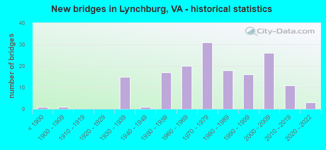
- New bridges - historical statistics
- 1Before 1900
- 11900-1909
- 151930-1939
- 11940-1949
- 171950-1959
- 201960-1969
- 311970-1979
- 181980-1989
- 161990-1999
- 262000-2009
- 112010-2019
- 32020-2022
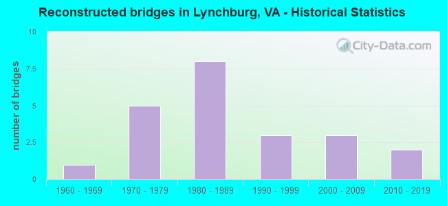
- Reconstructed bridges - Historical Statistics
- 11960-1969
- 51970-1979
- 81980-1989
- 31990-1999
- 32000-2009
- 22010-2019
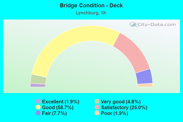
- Bridge Condition - Deck
- 1.9%Excellent
- 4.8%Very good
- 58.7%Good
- 25.0%Satisfactory
- 7.7%Fair
- 1.9%Poor
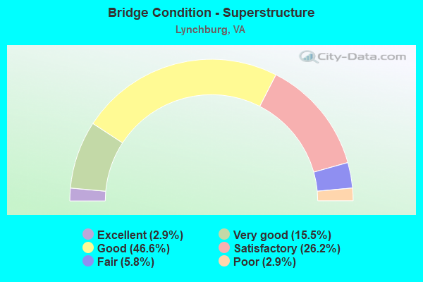
- Bridge Condition - Superstructure
- 2.9%Excellent
- 15.5%Very good
- 46.6%Good
- 26.2%Satisfactory
- 5.8%Fair
- 2.9%Poor
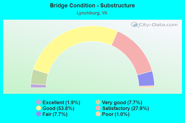
- Bridge Condition - Substructure
- 1.9%Excellent
- 7.7%Very good
- 53.8%Good
- 27.9%Satisfactory
- 7.7%Fair
- 1.0%Poor
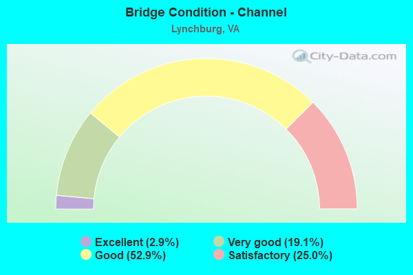
- Bridge Condition - Channel
- 2.9%Excellent
- 19.1%Very good
- 52.9%Good
- 25.0%Satisfactory
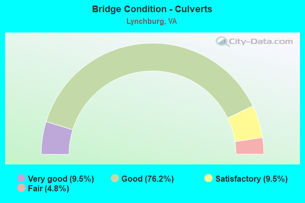
- Bridge Condition - Culverts
- 9.5%Very good
- 76.2%Good
- 9.5%Satisfactory
- 4.8%Fair
Find on map >> Show street view
Structure Number: 20531, Location: .03-Carroll/.10-15th St. (Lat: 37.398161, Lng: -79.155111), Route carried "on" structure: Bypass US 29, Year Built: 1959, Year Reconstructed: 1994, Status: Open, Structure Length: 4.53m (14.86ft), Average Daily Traffic: 35,034 (year 2020), Truck Traffic: 3%, Average Future Daily Traffic: 39,089 (year 2040), Design Load: HL 93, Features Intersected: Garfield Avenue & NS Rwy, Facility Carried by Structure: Lynchburg Exp
Minimum Vertical Clearance: 30+ m (98+ ft), Kilometerpoint: 8.125, Lanes on structure: 4, Lanes under structure: 2, Base Highway Network: Yes, Owner: City or Municipal Highway Agency, Approaching Roadway Width: 21.1m (69.2ft), Skew: 20 degrees, Material/Design: Steel, Design/Construction: Stringer/Multi-beam, Number Of Spans In Main Unit: 3, Length of Maximum Span: 22.6m (74.1ft), Curb-To-Curb Width: 21.1m (69.2ft), Out-to-Out Width: 22.9m (75.1ft)
Condition: Deck: Good, Superstructure: Good, Substructure: Good, Channel: Good, Operating Rating: 63.5 metric tons, Method Used To Determine Operating Rating: Load and Resistance Factor (LRFR), Inventory Rating: 49.0 metric tons, Method Used To Determine Inventory Rating: Load and Resistance Factor (LRFR), Structural Evaluation: Better than present minimum criteria, Deck Geometry: Better than present minimum criteria, Underclear: High priority of replacement, Approach Roadway Alignment: Somewhat better than minimum adequacy, Length Of Structure Improvement: 5.46m (17.91ft), Designated Inspection Frequency: Every 24 months, Inspection Date: March 2021, Bridge Improvement Cost: $1,564,000, Roadway Improvement Cost: $156,000, Total Project Cost: $2,346,000 ( Estimate for 2015), Deck Structure Type: Concrete Cast-file-Place, Wearing Surface/Protective System: Wearing Surface: Epoxy Overlay
Find on map >> Show street view
Structure Number: 20535, Location: 0.40-Rt.29/0.02-Rt.128 (Lat: 37.370825, Lng: -79.183631), Route carried "on" structure: State highway 163, Year Built: 1970, Year Reconstructed: 2013, Status: Open, Structure Length: 5.24m (17.19ft), Average Daily Traffic: 22,230 (year 2020), Truck Traffic: 2%, Average Future Daily Traffic: 31,122 (year 2040), Design Load: HS 20+Mod, Features Intersected: NS Railway, Facility Carried by Structure: Wards Road
Minimum Vertical Clearance: 30+ m (98+ ft), Kilometerpoint: 0.788, Lanes on structure: 5, Base Highway Network: Yes, Owner: City or Municipal Highway Agency, Approaching Roadway Width: 20.7m (67.9ft), Skew: 20 degrees, Material/Design: Steel, Design/Construction: Stringer/Multi-beam, Number Of Spans In Main Unit: 3, Length of Maximum Span: 19.8m (65.0ft), Curb or Sidewalk Widths: Left: 1.5m (4.9ft), Right: 1.5m (4.9ft), Curb-To-Curb Width: 20.7m (67.9ft), Out-to-Out Width: 24.4m (80.1ft)
Condition: Deck: Good, Superstructure: Good, Substructure: Good, Operating Rating: 63.5 metric tons, Method Used To Determine Operating Rating: Load and Resistance Factor (LRFR), Inventory Rating: 49.0 metric tons, Method Used To Determine Inventory Rating: Load and Resistance Factor (LRFR), Structural Evaluation: Better than present minimum criteria, Deck Geometry: Somewhat better than minimum adequacy, Underclear: Better than present minimum criteria, Approach Roadway Alignment: Equal to present minimum criteria, Designated Inspection Frequency: Every 24 months, Inspection Date: January 2020, Deck Structure Type: Concrete Cast-file-Place, Wearing Surface/Protective System: Wearing Surface: Latex Concrete
Find on map >> Show street view
Structure Number: 20536, Location: 0.30-Rt.128/0.01-Rt.29 (Lat: 37.365231, Lng: -79.182231), Route carried "on" structure: US 163, Year Built: 1964, Year Reconstructed: 1992, Status: Open, Structure Length: 9.63m (31.59ft), Average Daily Traffic: 14,242 (year 2020), Truck Traffic: 2%, Average Future Daily Traffic: 15,677 (year 2040), Design Load: HS 20+Mod, Features Intersected: Route 29 Expressway, Facility Carried by Structure: Wards Road(Rt. 29)
Minimum Vertical Clearance: 30+ m (98+ ft), Kilometerpoint: 0.177, Lanes on structure: 4, Lanes under structure: 4, Base Highway Network: Yes, Owner: City or Municipal Highway Agency, Approaching Roadway Width: 17.1m (56.1ft), Skew: 23 degrees, Material/Design: Steel, Design/Construction: Stringer/Multi-beam, Number Of Spans In Main Unit: 6, Length of Maximum Span: 20.6m (67.6ft), Curb or Sidewalk Widths: Left: 1.5m (4.9ft), Right: 0.5m (1.6ft), Curb-To-Curb Width: 18.0m (59.1ft), Out-to-Out Width: 20.3m (66.6ft)
Condition: Deck: Good, Superstructure: Good, Substructure: Satisfactory, Operating Rating: 60.8 metric tons, Method Used To Determine Operating Rating: Load and Resistance Factor (LRFR), Inventory Rating: 46.3 metric tons, Method Used To Determine Inventory Rating: Load and Resistance Factor (LRFR), Structural Evaluation: Equal to present minimum criteria, Deck Geometry: Somewhat better than minimum adequacy, Underclear: High priority of corrective action, Approach Roadway Alignment: Equal to present minimum criteria, Designated Inspection Frequency: Every 24 months, Inspection Date: June 2020, Deck Structure Type: Concrete Cast-file-Place, Wearing Surface/Protective System: Wearing Surface: Monolithic Concrete, Deck Protection: Epoxy Coated Reinforcing
Find on map >> Show street view
Structure Number: 20538, Location: .03-Chambers/.07-Filmore (Lat: 37.410347, Lng: -79.159342), Route carried "on" structure: Business US 29, Year Built: 1982, Status: Open, Structure Length: 14.23m (46.69ft), Average Daily Traffic: 10,022 (year 2020), Truck Traffic: 2%, Average Future Daily Traffic: 11,024 (year 2040), Design Load: HL 93, Features Intersected: NS Railroad, Facility Carried by Structure: 5th Street
Minimum Vertical Clearance: 30+ m (98+ ft), Kilometerpoint: 40.386, Lanes on structure: 2, Base Highway Network: Yes, Owner: City or Municipal Highway Agency, Approaching Roadway Width: 8.5m (27.9ft), Skew: 2 degrees, Material/Design: Steel continuous, Design/Construction: Stringer/Multi-beam, Number Of Spans In Main Unit: 3, Length of Maximum Span: 51.8m (169.9ft), Curb or Sidewalk Widths: Left: 1.5m (4.9ft), Right: 1.5m (4.9ft), Curb-To-Curb Width: 8.5m (27.9ft), Out-to-Out Width: 12.2m (40.0ft)
Condition: Deck: Good, Superstructure: Good, Substructure: Good, Operating Rating: 73.5 metric tons, Method Used To Determine Operating Rating: Load and Resistance Factor (LRFR), Inventory Rating: 56.2 metric tons, Method Used To Determine Inventory Rating: Load and Resistance Factor (LRFR), Structural Evaluation: Better than present minimum criteria, Deck Geometry: Meets minimum limits, Underclear: Better than present minimum criteria, Approach Roadway Alignment: Equal to present desirable criteria, Designated Inspection Frequency: Every 24 months, Inspection Date: January 2020, Deck Structure Type: Concrete Cast-file-Place, Wearing Surface/Protective System: Wearing Surface: Monolithic Concrete, Deck Protection: Epoxy Coated Reinforcing
Find on map >> Show street view
Structure Number: 20539, Location: 0.20-Rt.501/1.57-CL (Lat: 37.362394, Lng: -79.184025), Route carried "on" structure: Ramp US 29, Year Built: 1964, Status: Open, Structure Length: 0.82m (2.69ft), Average Daily Traffic: 15,000 (year 2019), Truck Traffic: 2%, Average Future Daily Traffic: 20,000 (year 2040), Design Load: HS 20, Features Intersected: Rock Castle Creek
Minimum Vertical Clearance: 30+ m (98+ ft), Kilometerpoint: 0.000, Lanes on structure: 2, Base Highway Network: Yes, Owner: City or Municipal Highway Agency, Approaching Roadway Width: 11.0m (36.1ft), Skew: 3 degrees, Material/Design: Concrete, Design/Construction: Culvert, Number Of Spans In Main Unit: 3, Length of Maximum Span: 2.7m (8.9ft)
Condition: Channel: Satisfactory, Culverts: Good, Operating Rating: 89.8 metric tons, Method Used To Determine Operating Rating: Load Factor (LF), Inventory Rating: 57.2 metric tons, Method Used To Determine Inventory Rating: Load Factor (LF), Structural Evaluation: Better than present minimum criteria, Waterway Adequacy: Somewhat better than minimum adequacy, Approach Roadway Alignment: Equal to present desirable criteria, Designated Inspection Frequency: Every 24 months, Inspection Date: July 2021
Find on map >> Show street view
Structure Number: 2054, Location: .30-501/1.50-City Limits (Lat: 37.361739, Lng: -79.183308), Route carried "on" structure: Ramp County highway 29, Year Built: 1964, Status: Open, Structure Length: 1.01m (3.31ft), Average Daily Traffic: 19,014 (year 2020), Truck Traffic: 3%, Average Future Daily Traffic: 26,620 (year 2040), Design Load: HS 20, Features Intersected: Rock Castle Creek
Minimum Vertical Clearance: 30+ m (98+ ft), Kilometerpoint: 0.000, Lanes on structure: 2, Base Highway Network: Yes, Owner: City or Municipal Highway Agency, Approaching Roadway Width: 11.0m (36.1ft), Skew: 4 degrees, Material/Design: Concrete, Design/Construction: Culvert, Number Of Spans In Main Unit: 3, Length of Maximum Span: 4.0m (13.1ft)
Condition: Channel: Very good, Culverts: Very good, Operating Rating: 85.3 metric tons, Method Used To Determine Operating Rating: Load Factor (LF), Inventory Rating: 50.8 metric tons, Method Used To Determine Inventory Rating: Load Factor (LF), Structural Evaluation: Equal to present desirable criteria, Waterway Adequacy: Better than present minimum criteria, Approach Roadway Alignment: Equal to present desirable criteria, Designated Inspection Frequency: Every 24 months, Inspection Date: July 2021
Find on map >> Show street view
Structure Number: 20541, Location: .02-Rt.501 & .00-Amherst (Lat: 37.418203, Lng: -79.143706), Route carried "on" structure: State highway 163, Year Built: 1988, Status: Open, Structure Length: 55.11m (180.81ft), Average Daily Traffic: 13,274 (year 2020), Truck Traffic: 1%, Average Future Daily Traffic: 13,689 (year 2040), Design Load: HS 20+Mod, Features Intersected: 7TH O NS;CSX;JAMES RV @, Facility Carried by Structure: 5th Street
Minimum Vertical Clearance: 30+ m (98+ ft), Kilometerpoint: 7.707, Lanes on structure: 4, Lanes under structure: 2, Base Highway Network: Yes, Owner: City or Municipal Highway Agency, Approaching Roadway Width: 21.9m (71.9ft), Skew: 20 degrees, Material/Design: Steel continuous, Design/Construction: Stringer/Multi-beam, Number Of Spans In Main Unit: 17, Number Of Approach Spans: 2, Length of Maximum Span: 49.1m (161.1ft), Curb-To-Curb Width: 21.9m (71.9ft), Out-to-Out Width: 23.0m (75.5ft)
Condition: Deck: Fair, Superstructure: Good, Substructure: Good, Channel: Good, Operating Rating: 49.0 metric tons, Method Used To Determine Operating Rating: Load and Resistance Factor (LRFR), Inventory Rating: 38.1 metric tons, Method Used To Determine Inventory Rating: Load and Resistance Factor (LRFR), Structural Evaluation: Better than present minimum criteria, Deck Geometry: Superior to present desirable criteria, Underclear: Meets minimum limits, Waterway Adequacy: Equal to present desirable criteria, Approach Roadway Alignment: Equal to present desirable criteria, Designated Inspection Frequency: Every 24 months, Critical Feature Inspection Frequency: Every 12 months, Underwater Inspection Frequency: Every 60 months, Inspection Date: January 2021, Critical Feature Inspection Date: January 2022, Underwater Inspection Date: March 2019, Deck Structure Type: Concrete Cast-file-Place, Wearing Surface/Protective System: Wearing Surface: Monolithic Concrete, Deck Protection: Epoxy Coated Reinforcing
Find on map >> Show street view
Structure Number: 20544, Location: 0051460 TMB R0091291 EXP (Lat: 37.371056, Lng: -79.207758), Route carried "on" structure: State highway 126, Year Built: 1957, Status: Open, Structure Length: 4.30m (14.11ft), Average Daily Traffic: 6,583 (year 2020), Truck Traffic: 3%, Average Future Daily Traffic: 7,371 (year 2040), Features Intersected: NS Railway, Facility Carried by Structure: Graves Mill Road
Minimum Vertical Clearance: 30+ m (98+ ft), Kilometerpoint: 2.607, Lanes on structure: 2, Owner: City or Municipal Highway Agency, Approaching Roadway Width: 9.8m (32.2ft), Skew: 3 degrees, Material/Design: Concrete, Design/Construction: Tee Beam, Number Of Spans In Main Unit: 3, Length of Maximum Span: 14.9m (48.9ft), Curb or Sidewalk Widths: Left: 0.5m (1.6ft), Right: 0.5m (1.6ft), Curb-To-Curb Width: 7.3m (24.0ft), Out-to-Out Width: 8.8m (28.9ft)
Condition: Deck: Satisfactory, Superstructure: Satisfactory, Substructure: Satisfactory, Operating Rating: 41.7 metric tons, Method Used To Determine Operating Rating: Load Factor (LF), Inventory Rating: 24.5 metric tons, Method Used To Determine Inventory Rating: Load Factor (LF), Structural Evaluation: Equal to present minimum criteria, Deck Geometry: High priority of replacement, Underclear: Somewhat better than minimum adequacy, Approach Roadway Alignment: Equal to present minimum criteria, Length Of Structure Improvement: 5.33m (17.49ft), Designated Inspection Frequency: Every 24 months, Inspection Date: July 2020, Bridge Improvement Cost: $931,000, Roadway Improvement Cost: $93,000, Total Project Cost: $1,397,000 ( Estimate for 2014), Deck Structure Type: Concrete Cast-file-Place, Wearing Surface/Protective System: Wearing Surface: Latex Concrete
Find on map >> Show street view
Structure Number: 20545, Location: 0142460 0139BEDFOR C (Lat: 37.377153, Lng: -79.220767), Route carried "on" structure: State highway 126, Year Built: 1975, Status: Open, Structure Length: 5.85m (19.19ft), Average Daily Traffic: 9,762 (year 2020), Truck Traffic: 3%, Average Future Daily Traffic: 13,667 (year 2040), Design Load: HS 20+Mod, Features Intersected: US Rte 501 Lynch Exprway, Facility Carried by Structure: Graves Mill Road
Minimum Vertical Clearance: 30+ m (98+ ft), Kilometerpoint: 2.333, Lanes on structure: 4, Lanes under structure: 4, Owner: City or Municipal Highway Agency, Approaching Roadway Width: 25.6m (84.0ft), Skew: 21 degrees, Material/Design: Steel continuous, Design/Construction: Stringer/Multi-beam, Number Of Spans In Main Unit: 2, Length of Maximum Span: 29.3m (96.1ft), Curb-To-Curb Width: 25.6m (84.0ft), Out-to-Out Width: 26.8m (87.9ft)
Condition: Deck: Satisfactory, Superstructure: Satisfactory, Substructure: Satisfactory, Operating Rating: 86.2 metric tons, Method Used To Determine Operating Rating: Load and Resistance Factor (LRFR), Inventory Rating: 66.2 metric tons, Method Used To Determine Inventory Rating: Load and Resistance Factor (LRFR), Structural Evaluation: Equal to present minimum criteria, Deck Geometry: Superior to present desirable criteria, Underclear: Somewhat better than minimum adequacy, Approach Roadway Alignment: Equal to present minimum criteria, Designated Inspection Frequency: Every 24 months, Inspection Date: March 2020, Deck Structure Type: Concrete Cast-file-Place, Wearing Surface/Protective System: Wearing Surface: Monolithic Concrete
Find on map >> Show street view
Structure Number: 20547, Location: .29 Rt 29BP/1.43 Rt 460BP (Lat: 37.368817, Lng: -79.178244), Route carried "on" structure: Bypass State highway 128, Year Built: 1959, Year Reconstructed: 1983, Status: Open, Structure Length: 4.38m (14.37ft), Average Daily Traffic: 35,000 (year 2020), Truck Traffic: 3%, Average Future Daily Traffic: 40,000 (year 2042), Features Intersected: Route 29 Business, Facility Carried by Structure: Candlers Mtn Rd
Minimum Vertical Clearance: 30+ m (98+ ft), Kilometerpoint: 0.434, Lanes on structure: 6, Lanes under structure: 4, Owner: State Highway Agency, Approaching Roadway Width: 25.3m (83.0ft), Skew: 32 degrees, Material/Design: Steel, Design/Construction: Stringer/Multi-beam, Number Of Spans In Main Unit: 3, Length of Maximum Span: 23.6m (77.4ft), Curb-To-Curb Width: 24.5m (80.4ft), Out-to-Out Width: 26.5m (86.9ft)
Condition: Deck: Fair, Superstructure: Poor, Substructure: Fair, Operating Rating: 43.5 metric tons, Method Used To Determine Operating Rating: Load and Resistance Factor (LRFR), Inventory Rating: 33.6 metric tons, Method Used To Determine Inventory Rating: Load and Resistance Factor (LRFR), Structural Evaluation: Meets minimum limits, Deck Geometry: Somewhat better than minimum adequacy, Underclear: High priority of replacement, Approach Roadway Alignment: Equal to present desirable criteria, Length Of Structure Improvement: 5.27m (17.29ft), Designated Inspection Frequency: Every 12 months, Inspection Date: September 2021, Bridge Improvement Cost: $1,512,000, Roadway Improvement Cost: $151,000, Total Project Cost: $2,268,000 ( Estimate for 2015), Deck Structure Type: Concrete Cast-file-Place
Find on map >> Show street view
Structure Number: 20549, Location: 0.32-Rt 29 Bs/0.29-29 Bp (Lat: 37.366003, Lng: -79.172606), Route carried "on" structure: State highway 128, Year Built: 1958, Year Reconstructed: 2013, Status: Open, Structure Length: 8.07m (26.48ft), Average Daily Traffic: 17,639 (year 2020), Truck Traffic: 4%, Average Future Daily Traffic: 24,695 (year 2040), Design Load: HS 20+Mod, Features Intersected: NS Railroad, Facility Carried by Structure: Candlers Mtn. Rd W
Minimum Vertical Clearance: 30+ m (98+ ft), Kilometerpoint: 1.239, Lanes on structure: 2, Base Highway Network: Yes, Owner: State Highway Agency, Approaching Roadway Width: 9.8m (32.2ft), Material/Design: Steel, Design/Construction: Stringer/Multi-beam, Number Of Spans In Main Unit: 4, Length of Maximum Span: 22.6m (74.1ft), Curb-To-Curb Width: 11.0m (36.1ft), Out-to-Out Width: 11.5m (37.7ft)
Condition: Deck: Very good, Superstructure: Good, Substructure: Good, Operating Rating: 59.9 metric tons, Method Used To Determine Operating Rating: Load and Resistance Factor (LRFR), Inventory Rating: 45.4 metric tons, Method Used To Determine Inventory Rating: Load and Resistance Factor (LRFR), Structural Evaluation: Better than present minimum criteria, Deck Geometry: Equal to present minimum criteria, Approach Roadway Alignment: Equal to present desirable criteria, Designated Inspection Frequency: Every 24 months, Inspection Date: May 2021, Deck Structure Type: Concrete Cast-file-Place
Find on map >> Show street view
Structure Number: 20552, Location: .32-Rt 29/ 79-Rt 460 Bypa (Lat: 37.365814, Lng: -79.172769), Route carried "on" structure: State highway 128, Year Built: 1976, Status: Open, Structure Length: 8.21m (26.94ft), Average Daily Traffic: 17,000 (year 2018), Truck Traffic: 4%, Average Future Daily Traffic: 25,000 (year 2035), Design Load: HS 20+Mod, Features Intersected: NS Railway, Facility Carried by Structure: Candlers Mt Rd EBL
Minimum Vertical Clearance: 30+ m (98+ ft), Kilometerpoint: 2.237, Lanes on structure: 2, Owner: State Highway Agency, Approaching Roadway Width: 7.9m (25.9ft), Material/Design: Steel, Design/Construction: Stringer/Multi-beam, Number Of Spans In Main Unit: 3, Length of Maximum Span: 40.1m (131.6ft), Curb-To-Curb Width: 11.0m (36.1ft), Out-to-Out Width: 12.2m (40.0ft)
Condition: Deck: Satisfactory, Superstructure: Satisfactory, Substructure: Good, Operating Rating: 75.3 metric tons, Method Used To Determine Operating Rating: Load and Resistance Factor (LRFR), Inventory Rating: 58.1 metric tons, Method Used To Determine Inventory Rating: Load and Resistance Factor (LRFR), Structural Evaluation: Equal to present minimum criteria, Deck Geometry: Equal to present minimum criteria, Underclear: Better than present minimum criteria, Approach Roadway Alignment: Equal to present minimum criteria, Designated Inspection Frequency: Every 24 months, Inspection Date: April 2020, Deck Structure Type: Concrete Cast-file-Place, Wearing Surface/Protective System: Wearing Surface: Monolithic Concrete
Find on map >> Show street view
Structure Number: 20555, Location: .12 501 / 1.22 NCL LYNC (Lat: 37.403614, Lng: -79.155794), Route carried "on" structure: US 221, Year Built: 1932, Status: Open, Structure Length: 1.02m (3.35ft), Average Daily Traffic: 8,412 (year 2020), Truck Traffic: 4%, Average Future Daily Traffic: 9,657 (year 2040), Features Intersected: NS Railway, Facility Carried by Structure: 12th Street
Minimum Vertical Clearance: 30+ m (98+ ft), Kilometerpoint: 7.562, Lanes on structure: 2, Owner: City or Municipal Highway Agency, Approaching Roadway Width: 12.2m (40.0ft), Material/Design: Concrete, Design/Construction: Slab, Number Of Spans In Main Unit: 1, Length of Maximum Span: 10.2m (33.5ft), Curb or Sidewalk Widths: Left: 1.2m (3.9ft), Right: 1.5m (4.9ft), Curb-To-Curb Width: 12.2m (40.0ft), Out-to-Out Width: 16.0m (52.5ft)
Condition: Deck: Fair, Superstructure: Fair, Substructure: Satisfactory, Operating Rating: 25.4 metric tons, Method Used To Determine Operating Rating: Field evaluation and documented engineering judgment, Inventory Rating: 14.5 metric tons, Method Used To Determine Inventory Rating: Field evaluation and documented engineering judgment, Structural Evaluation: High priority of corrective action, Deck Geometry: Somewhat better than minimum adequacy, Underclear: High priority of corrective action, Approach Roadway Alignment: Equal to present minimum criteria, Designated Inspection Frequency: Every 24 months, Inspection Date: May 2021, Deck Structure Type: Concrete Cast-file-Place, Wearing Surface/Protective System: Wearing Surface: Bituminous
Find on map >> Show street view
Structure Number: 20556, Location: 0019291 0084WCL LYNC (Lat: 37.401622, Lng: -79.183925), Route carried "on" structure: US 221, Year Built: 1935, Status: Open, Structure Length: 2.99m (9.81ft), Average Daily Traffic: 12,794 (year 2020), Truck Traffic: 1%, Average Future Daily Traffic: 14,073 (year 2040), Design Load: H 15, Features Intersected: Blackwater Creek, Facility Carried by Structure: Lakeside Drive
Minimum Vertical Clearance: 30+ m (98+ ft), Kilometerpoint: 4.505, Lanes on structure: 2, Owner: City or Municipal Highway Agency, Approaching Roadway Width: 10.1m (33.1ft), Material/Design: Concrete, Design/Construction: Arch - Deck, Number Of Spans In Main Unit: 1, Length of Maximum Span: 29.9m (98.1ft), Curb or Sidewalk Widths: Left: 1.6m (5.2ft), Right: 0.3m (1.0ft), Curb-To-Curb Width: 10.1m (33.1ft), Out-to-Out Width: 12.9m (42.3ft)
Condition: Deck: Satisfactory, Superstructure: Satisfactory, Substructure: Good, Channel: Good, Operating Rating: 45.4 metric tons, Method Used To Determine Operating Rating: Load Factor (LF), Inventory Rating: 35.0 metric tons, Method Used To Determine Inventory Rating: Load Factor (LF), Structural Evaluation: Equal to present minimum criteria, Deck Geometry: Meets minimum limits, Waterway Adequacy: Better than present minimum criteria, Approach Roadway Alignment: Equal to present minimum criteria, Length Of Structure Improvement: 3.87m (12.70ft), Designated Inspection Frequency: Every 24 months, Inspection Date: November 2020, Bridge Improvement Cost: $1,110,000, Roadway Improvement Cost: $111,000, Total Project Cost: $1,665,000 ( Estimate for 2015), Wearing Surface/Protective System: Wearing Surface: Bituminous
Find on map >> Show street view
Structure Number: 20557, Location: 0047221 0125LINKHYDR (Lat: 37.405233, Lng: -79.187908), Route carried "on" structure: State highway 291, Year Built: 1932, Year Reconstructed: 1985, Status: Open, Structure Length: 2.36m (7.74ft), Average Daily Traffic: 7,586 (year 2020), Truck Traffic: 1%, Average Future Daily Traffic: 8,345 (year 2040), Design Load: HS 20, Features Intersected: Blackwater Creek, Facility Carried by Structure: Old Forest Road
Minimum Vertical Clearance: 30+ m (98+ ft), Kilometerpoint: 0.756, Lanes on structure: 2, Owner: City or Municipal Highway Agency, Approaching Roadway Width: 8.5m (27.9ft), Material/Design: Steel, Design/Construction: Stringer/Multi-beam, Number Of Spans In Main Unit: 2, Length of Maximum Span: 11.8m (38.7ft), Curb or Sidewalk Widths: Left: 0.0m, Right: 1.5m (4.9ft), Curb-To-Curb Width: 8.5m (27.9ft), Out-to-Out Width: 10.9m (35.8ft)
Condition: Deck: Good, Superstructure: Good, Substructure: Good, Channel: Good, Operating Rating: 67.1 metric tons, Method Used To Determine Operating Rating: Load and Resistance Factor (LRFR), Inventory Rating: 51.7 metric tons, Method Used To Determine Inventory Rating: Load and Resistance Factor (LRFR), Structural Evaluation: Better than present minimum criteria, Deck Geometry: High priority of replacement, Waterway Adequacy: Equal to present desirable criteria, Approach Roadway Alignment: Better than present minimum criteria, Length Of Structure Improvement: 2.29m (7.51ft), Designated Inspection Frequency: Every 24 months, Inspection Date: Febuary 2021, Bridge Improvement Cost: $50,000, Roadway Improvement Cost: $5,000, Total Project Cost: $75,000 ( Estimate for 2015), Deck Structure Type: Concrete Cast-file-Place, Wearing Surface/Protective System: Wearing Surface: Monolithic Concrete, Deck Protection: Epoxy Coated Reinforcing
Find on map >> Show street view
Structure Number: 20558, Location: .99 460 / .90 WCL LYNCH (Lat: 37.401975, Lng: -79.222281), Route carried "on" structure: State highway 291, Year Built: 1948, Year Reconstructed: 1985, Status: Open, Structure Length: 2.80m (9.19ft), Average Daily Traffic: 7,586 (year 2020), Truck Traffic: 1%, Average Future Daily Traffic: 8,345 (year 2040), Design Load: HS 20+Mod, Features Intersected: NS Railroad, Facility Carried by Structure: Old Forest Road
Minimum Vertical Clearance: 30+ m (98+ ft), Kilometerpoint: 1.593, Lanes on structure: 2, Owner: City or Municipal Highway Agency, Approaching Roadway Width: 8.5m (27.9ft), Material/Design: Steel, Design/Construction: Stringer/Multi-beam, Number Of Spans In Main Unit: 1, Length of Maximum Span: 28.0m (91.9ft), Curb or Sidewalk Widths: Left: 1.4m (4.6ft), Right: 1.4m (4.6ft), Curb-To-Curb Width: 8.5m (27.9ft), Out-to-Out Width: 11.9m (39.0ft)
Condition: Deck: Good, Superstructure: Good, Substructure: Good, Operating Rating: 93.4 metric tons, Method Used To Determine Operating Rating: Load and Resistance Factor (LRFR), Inventory Rating: 71.7 metric tons, Method Used To Determine Inventory Rating: Load and Resistance Factor (LRFR), Structural Evaluation: Better than present minimum criteria, Deck Geometry: High priority of replacement, Underclear: Meets minimum limits, Approach Roadway Alignment: Better than present minimum criteria, Length Of Structure Improvement: 2.80m (9.19ft), Designated Inspection Frequency: Every 24 months, Inspection Date: March 2020, Bridge Improvement Cost: $80,000, Roadway Improvement Cost: $8,000, Total Project Cost: $120,000 ( Estimate for 2014), Deck Structure Type: Concrete Cast-file-Place, Wearing Surface/Protective System: Deck Protection: Epoxy Coated Reinforcing
Find on map >> Show street view
Structure Number: 20559, Location: .1-BergerSt./.16-LynchExp (Lat: 37.410375, Lng: -79.194772), Route carried "on" structure: State highway 291, Year Built: 1967, Status: Open, Structure Length: 3.91m (12.83ft), Average Daily Traffic: 18,814 (year 2020), Truck Traffic: 1%, Average Future Daily Traffic: 20,695 (year 2040), Design Load: HS 20+Mod, Features Intersected: NS Railway, Facility Carried by Structure: Old Forest Road
Minimum Vertical Clearance: 30+ m (98+ ft), Kilometerpoint: 5.036, Lanes on structure: 4, Owner: City or Municipal Highway Agency, Approaching Roadway Width: 13.4m (44.0ft), Skew: 1 degrees, Material/Design: Concrete, Design/Construction: Tee Beam, Number Of Spans In Main Unit: 3, Length of Maximum Span: 13.1m (43.0ft), Curb or Sidewalk Widths: Left: 1.5m (4.9ft), Right: 1.5m (4.9ft), Curb-To-Curb Width: 13.4m (44.0ft), Out-to-Out Width: 17.1m (56.1ft)
Condition: Deck: Good, Superstructure: Good, Substructure: Satisfactory, Operating Rating: 42.6 metric tons, Method Used To Determine Operating Rating: Load and Resistance Factor (LRFR), Inventory Rating: 35.4 metric tons, Method Used To Determine Inventory Rating: Load and Resistance Factor (LRFR), Structural Evaluation: Equal to present minimum criteria, Deck Geometry: High priority of replacement, Underclear: Meets minimum limits, Approach Roadway Alignment: Better than present minimum criteria, Length Of Structure Improvement: 4.82m (15.81ft), Designated Inspection Frequency: Every 24 months, Inspection Date: September 2020, Bridge Improvement Cost: $841,000, Roadway Improvement Cost: $84,000, Total Project Cost: $1,261,000 ( Estimate for 2014), Deck Structure Type: Concrete Cast-file-Place, Wearing Surface/Protective System: Wearing Surface: Latex Concrete
Find on map >> Show street view
Structure Number: 2056, Location: 0.21-Grav. Mill./1.17-221 (Lat: 37.380531, Lng: -79.222450), Route carried "on" structure: Bypass State highway 501, Year Built: 1975, Status: Open, Structure Length: 0.94m (3.08ft), Average Daily Traffic: 15,943 (year 2020), Truck Traffic: 4%, Average Future Daily Traffic: 22,322 (year 2040), Design Load: HS 20, Features Intersected: Tomahawk Creek
Minimum Vertical Clearance: 30+ m (98+ ft), Kilometerpoint: 7.594, Lanes on structure: 4, Base Highway Network: Yes, Owner: City or Municipal Highway Agency, Approaching Roadway Width: 13.1m (43.0ft), Material/Design: Concrete, Design/Construction: Culvert, Number Of Spans In Main Unit: 3, Length of Maximum Span: 3.0m (9.8ft)
Condition: Channel: Satisfactory, Culverts: Good, Operating Rating: 89.8 metric tons, Method Used To Determine Operating Rating: Load Factor (LF), Inventory Rating: 89.8 metric tons, Method Used To Determine Inventory Rating: Load Factor (LF), Structural Evaluation: Better than present minimum criteria, Waterway Adequacy: Superior to present desirable criteria, Approach Roadway Alignment: Somewhat better than minimum adequacy, Designated Inspection Frequency: Every 24 months, Inspection Date: July 2021, Wearing Surface/Protective System: Wearing Surface: Bituminous
Find on map >> Show street view
Structure Number: 20561, Location: .84-460Bus/.39-Gravesmill (Lat: 37.373883, Lng: -79.214892), Route carried "on" structure: Bypass State highway 501, Year Built: 1975, Status: Open, Structure Length: 0.73m (2.40ft), Average Daily Traffic: 44,185 (year 2020), Truck Traffic: 4%, Average Future Daily Traffic: 61,859 (year 2040), Design Load: HS 20, Features Intersected: Dreaming Creek
Minimum Vertical Clearance: 30+ m (98+ ft), Kilometerpoint: 8.576, Lanes on structure: 4, Base Highway Network: Yes, Owner: City or Municipal Highway Agency, Approaching Roadway Width: 13.1m (43.0ft), Material/Design: Concrete, Design/Construction: Culvert, Number Of Spans In Main Unit: 3, Length of Maximum Span: 2.4m (7.9ft)
Condition: Channel: Satisfactory, Culverts: Satisfactory, Operating Rating: 89.8 metric tons, Method Used To Determine Operating Rating: Load Factor (LF), Inventory Rating: 55.3 metric tons, Method Used To Determine Inventory Rating: Load Factor (LF), Structural Evaluation: Equal to present minimum criteria, Waterway Adequacy: Somewhat better than minimum adequacy, Approach Roadway Alignment: Better than present minimum criteria, Designated Inspection Frequency: Every 24 months, Inspection Date: December 2020, Wearing Surface/Protective System: Wearing Surface: Bituminous
Find on map >> Show street view
Structure Number: 20563, Location: .07 29/.35 Wards Ferry Rd (Lat: 37.355833, Lng: -79.199167), Route carried "on" structure: State highway 368, Year Built: 1969, Year Reconstructed: 2010, Status: Open, Structure Length: 0.78m (2.56ft), Average Daily Traffic: 10,832 (year 2020), Average Future Daily Traffic: 15,165 (year 2040), Features Intersected: Burton Creek, Facility Carried by Structure: Harvard Street
Minimum Vertical Clearance: 30+ m (98+ ft), Kilometerpoint: 0.113, Lanes on structure: 2, Owner: State Highway Agency, Approaching Roadway Width: 7.3m (24.0ft), Skew: 3 degrees, Material/Design: Steel, Design/Construction: Culvert, Number Of Spans In Main Unit: 2, Length of Maximum Span: 3.5m (11.5ft)
Condition: Channel: Satisfactory, Culverts: Good, Operating Rating: 89.8 metric tons, Method Used To Determine Operating Rating: Load Factor (LF), Inventory Rating: 89.8 metric tons, Method Used To Determine Inventory Rating: Load Factor (LF), Structural Evaluation: Better than present minimum criteria, Waterway Adequacy: Equal to present minimum criteria, Approach Roadway Alignment: Equal to present desirable criteria, Designated Inspection Frequency: Every 24 months, Inspection Date: July 2020
Find on map >> Show street view
Structure Number: 20564, Location: 001929&29ALT 0011WCL LYNC (Lat: 37.363397, Lng: -79.184986), Route carried "on" structure: US 501, Year Built: 1965, Status: Open, Structure Length: 4.73m (15.52ft), Average Daily Traffic: 39,000 (year 2020), Truck Traffic: 2%, Average Future Daily Traffic: 53,572 (year 2040), Design Load: HS 20, Features Intersected: US 29 Bus SBL, Facility Carried by Structure: SBL Lynchburg Expr
Minimum Vertical Clearance: 30+ m (98+ ft), Kilometerpoint: 21.351, Lanes on structure: 2, Lanes under structure: 2, Base Highway Network: Yes, Owner: City or Municipal Highway Agency, Approaching Roadway Width: 9.1m (29.9ft), Skew: 4 degrees, Material/Design: Steel, Design/Construction: Stringer/Multi-beam, Number Of Spans In Main Unit: 3, Length of Maximum Span: 18.9m (62.0ft), Curb or Sidewalk Widths: Left: 0.5m (1.6ft), Right: 0.5m (1.6ft), Curb-To-Curb Width: 9.1m (29.9ft), Out-to-Out Width: 10.7m (35.1ft)
Condition: Deck: Good, Superstructure: Satisfactory, Substructure: Very good, Operating Rating: 63.5 metric tons, Method Used To Determine Operating Rating: Load Factor (LF), Inventory Rating: 49.0 metric tons, Method Used To Determine Inventory Rating: Load Factor (LF), Structural Evaluation: Equal to present minimum criteria, Deck Geometry: High priority of replacement, Underclear: High priority of replacement, Approach Roadway Alignment: Equal to present minimum criteria, Length Of Structure Improvement: 4.72m (15.49ft), Designated Inspection Frequency: Every 24 months, Inspection Date: December 2021, Bridge Improvement Cost: $1,354,000, Roadway Improvement Cost: $135,000, Total Project Cost: $2,032,000, Deck Structure Type: Concrete Cast-file-Place, Wearing Surface/Protective System: Wearing Surface: Latex Concrete
Find on map >> Show street view
Structure Number: 20566, Location: 1.78-Rt 128/0.32-Rt 501 (Lat: 37.377089, Lng: -79.136508), Route carried "on" structure: Bypass US 29, Year Built: 1976, Status: Open, Structure Length: 8.63m (28.31ft), Average Daily Traffic: 17,736 (year 2020), Truck Traffic: 7%, Average Future Daily Traffic: 24,830 (year 2040), Design Load: HS 20+Mod, Features Intersected: Rt 677 & NS Railway
Minimum Vertical Clearance: 30+ m (98+ ft), Kilometerpoint: 331.374, Lanes on structure: 2, Lanes under structure: 2, Base Highway Network: Yes, Owner: State Highway Agency, Approaching Roadway Width: 7.9m (25.9ft), Skew: 4 degrees, Material/Design: Steel, Design/Construction: Stringer/Multi-beam, Number Of Spans In Main Unit: 4, Length of Maximum Span: 27.4m (89.9ft), Curb-To-Curb Width: 11.6m (38.1ft), Out-to-Out Width: 12.8m (42.0ft)
Condition: Deck: Good, Superstructure: Good, Substructure: Fair, Operating Rating: 68.0 metric tons, Method Used To Determine Operating Rating: Load and Resistance Factor (LRFR), Inventory Rating: 52.6 metric tons, Method Used To Determine Inventory Rating: Load and Resistance Factor (LRFR), Structural Evaluation: Somewhat better than minimum adequacy, Deck Geometry: Equal to present minimum criteria, Underclear: High priority of corrective action, Approach Roadway Alignment: Equal to present desirable criteria, Designated Inspection Frequency: Every 24 months, Inspection Date: May 2020, Deck Structure Type: Concrete Cast-file-Place, Wearing Surface/Protective System: Wearing Surface: Epoxy Overlay
Find on map >> Show street view
Structure Number: 20568, Location: 1.78-Rt 128 / 0.32-Rt 501 (Lat: 37.376989, Lng: -79.136289), Route carried "on" structure: Bypass US 29, Year Built: 1976, Status: Open, Structure Length: 8.63m (28.31ft), Average Daily Traffic: 17,736 (year 2020), Truck Traffic: 7%, Average Future Daily Traffic: 24,830 (year 2040), Design Load: HS 20+Mod, Features Intersected: Rt. 677 & NS Railway
Minimum Vertical Clearance: 30+ m (98+ ft), Kilometerpoint: 331.374, Lanes on structure: 2, Lanes under structure: 2, Base Highway Network: Yes, Owner: State Highway Agency, Approaching Roadway Width: 11.6m (38.1ft), Skew: 4 degrees, Material/Design: Steel, Design/Construction: Stringer/Multi-beam, Number Of Spans In Main Unit: 4, Length of Maximum Span: 27.4m (89.9ft), Curb-To-Curb Width: 11.6m (38.1ft), Out-to-Out Width: 12.8m (42.0ft)
Condition: Deck: Satisfactory, Superstructure: Satisfactory, Substructure: Satisfactory, Operating Rating: 69.9 metric tons, Method Used To Determine Operating Rating: Load and Resistance Factor (LRFR), Inventory Rating: 53.5 metric tons, Method Used To Determine Inventory Rating: Load and Resistance Factor (LRFR), Structural Evaluation: Equal to present minimum criteria, Deck Geometry: Better than present minimum criteria, Underclear: High priority of replacement, Approach Roadway Alignment: Equal to present desirable criteria, Length Of Structure Improvement: 9.81m (32.19ft), Designated Inspection Frequency: Every 24 months, Inspection Date: Febuary 2021, Bridge Improvement Cost: $2,814,000, Roadway Improvement Cost: $281,000, Total Project Cost: $4,221,000 ( Estimate for 2015), Deck Structure Type: Concrete Cast-file-Place, Wearing Surface/Protective System: Wearing Surface: Epoxy Overlay
Find on map >> Show street view
Structure Number: 2057, Location: 0.5-Rt.29bus./1.5-Rt.29 (Lat: 37.392706, Lng: -79.148306), Route carried "on" structure: Business US 460, Year Built: 1937, Year Reconstructed: 1999, Status: Open, Structure Length: 5.13m (16.83ft), Average Daily Traffic: 16,435 (year 2020), Truck Traffic: 1%, Average Future Daily Traffic: 18,078 (year 2040), Design Load: HS 20+Mod, Features Intersected: NS Railway
Minimum Vertical Clearance: 30+ m (98+ ft), Kilometerpoint: 9.348, Lanes on structure: 4, Owner: City or Municipal Highway Agency, Approaching Roadway Width: 17.1m (56.1ft), Skew: 23 degrees, Material/Design: Steel continuous, Design/Construction: Stringer/Multi-beam, Number Of Spans In Main Unit: 3, Length of Maximum Span: 22.6m (74.1ft), Curb or Sidewalk Widths: Left: 1.6m (5.2ft), Right: 1.6m (5.2ft), Curb-To-Curb Width: 17.1m (56.1ft), Out-to-Out Width: 20.9m (68.6ft)
Condition: Deck: Good, Superstructure: Good, Substructure: Good, Operating Rating: 87.1 metric tons, Method Used To Determine Operating Rating: Load and Resistance Factor (LRFR), Inventory Rating: 67.1 metric tons, Method Used To Determine Inventory Rating: Load and Resistance Factor (LRFR), Structural Evaluation: Better than present minimum criteria, Deck Geometry: Somewhat better than minimum adequacy, Underclear: Superior to present desirable criteria, Approach Roadway Alignment: Equal to present minimum criteria, Designated Inspection Frequency: Every 24 months, Inspection Date: January 2020, Deck Structure Type: Concrete Cast-file-Place, Wearing Surface/Protective System: Wearing Surface: Monolithic Concrete
Find on map >> Show street view
Structure Number: 20574, Location: 0118128 000829 (Lat: 37.398167, Lng: -79.150264), Route carried "on" structure: Business US 501, Year Built: 1966, Status: Open, Structure Length: 3.40m (11.15ft), Average Daily Traffic: 8,495 (year 2020), Truck Traffic: 2%, Average Future Daily Traffic: 9,344 (year 2040), Design Load: HL 93, Features Intersected: Fishing Creek
Minimum Vertical Clearance: 30+ m (98+ ft), Kilometerpoint: 3.057, Lanes on structure: 4, Owner: City or Municipal Highway Agency, Approaching Roadway Width: 17.1m (56.1ft), Skew: 2 degrees, Material/Design: Concrete, Design/Construction: Frame, Number Of Spans In Main Unit: 3, Length of Maximum Span: 7.0m (23.0ft), Curb-To-Curb Width: 17.1m (56.1ft), Out-to-Out Width: 21.3m (69.9ft)
Condition: Deck: Good, Superstructure: Good, Substructure: Satisfactory, Channel: Good, Operating Rating: 42.6 metric tons, Method Used To Determine Operating Rating: Load and Resistance Factor (LRFR), Inventory Rating: 32.7 metric tons, Method Used To Determine Inventory Rating: Load and Resistance Factor (LRFR), Structural Evaluation: Equal to present minimum criteria, Deck Geometry: Somewhat better than minimum adequacy, Waterway Adequacy: Better than present minimum criteria, Approach Roadway Alignment: Equal to present minimum criteria, Designated Inspection Frequency: Every 24 months, Inspection Date: August 2021
Find on map >> Show street view
Structure Number: 20575, Location: 0018WCL LYNCH0274BEDFO CO (Lat: 37.366186, Lng: -79.203575), Route carried "on" structure: US 460, Year Built: 1964, Year Reconstructed: 1987, Status: Open, Structure Length: 7.13m (23.39ft), Average Daily Traffic: 7,842 (year 2020), Truck Traffic: 1%, Average Future Daily Traffic: 10,980 (year 2040), Design Load: HS 20+Mod, Features Intersected: 501, Facility Carried by Structure: Timberlake Road WB
Minimum Vertical Clearance: 30+ m (98+ ft), Kilometerpoint: 23.411, Lanes on structure: 3, Lanes under structure: 6, Base Highway Network: Yes, Owner: City or Municipal Highway Agency, Approaching Roadway Width: 12.5m (41.0ft), Skew: 2 degrees, Material/Design: Steel, Design/Construction: Stringer/Multi-beam, Number Of Spans In Main Unit: 4, Length of Maximum Span: 22.7m (74.5ft), Curb or Sidewalk Widths: Left: 0.5m (1.6ft), Right: 0.5m (1.6ft), Curb-To-Curb Width: 12.5m (41.0ft), Out-to-Out Width: 14.0m (45.9ft)
Condition: Deck: Fair, Superstructure: Satisfactory, Substructure: Fair, Operating Rating: 55.3 metric tons, Method Used To Determine Operating Rating: Load and Resistance Factor (LRFR), Inventory Rating: 42.6 metric tons, Method Used To Determine Inventory Rating: Load and Resistance Factor (LRFR), Structural Evaluation: Somewhat better than minimum adequacy, Deck Geometry: Meets minimum limits, Underclear: Meets minimum limits, Approach Roadway Alignment: Equal to present desirable criteria, Length Of Structure Improvement: 8.23m (27.00ft), Designated Inspection Frequency: Every 24 months, Inspection Date: April 2020, Bridge Improvement Cost: $2,462,000, Roadway Improvement Cost: $246,000, Total Project Cost: $3,694,000 ( Estimate for 2014), Deck Structure Type: Concrete Cast-file-Place, Wearing Surface/Protective System: Wearing Surface: Latex Concrete, Deck Protection: Epoxy Coated Reinforcing
Find on map >> Show street view
Structure Number: 20577, Location: 0014126 0214CAMPBE C (Lat: 37.366131, Lng: -79.203375), Route carried "on" structure: US 460, Year Built: 1964, Year Reconstructed: 1987, Status: Open, Structure Length: 6.99m (22.93ft), Average Daily Traffic: 15,288 (year 2020), Truck Traffic: 1%, Average Future Daily Traffic: 21,405 (year 2040), Design Load: HS 20+Mod, Features Intersected: Route 501, Facility Carried by Structure: EBL Timberlake Rd.
Minimum Vertical Clearance: 30+ m (98+ ft), Kilometerpoint: 23.411, Lanes on structure: 3, Lanes under structure: 4, Base Highway Network: Yes, Owner: City or Municipal Highway Agency, Approaching Roadway Width: 12.5m (41.0ft), Skew: 2 degrees, Material/Design: Steel, Design/Construction: Stringer/Multi-beam, Number Of Spans In Main Unit: 4, Length of Maximum Span: 22.9m (75.1ft), Curb or Sidewalk Widths: Left: 0.5m (1.6ft), Right: 0.5m (1.6ft), Curb-To-Curb Width: 12.5m (41.0ft), Out-to-Out Width: 14.0m (45.9ft)
Condition: Deck: Satisfactory, Superstructure: Satisfactory, Substructure: Satisfactory, Operating Rating: 52.6 metric tons, Method Used To Determine Operating Rating: Load and Resistance Factor (LRFR), Inventory Rating: 40.8 metric tons, Method Used To Determine Inventory Rating: Load and Resistance Factor (LRFR), Structural Evaluation: Equal to present minimum criteria, Deck Geometry: Meets minimum limits, Underclear: High priority of replacement, Approach Roadway Alignment: Better than present minimum criteria, Length Of Structure Improvement: 7.71m (25.30ft), Designated Inspection Frequency: Every 24 months, Inspection Date: April 2020, Bridge Improvement Cost: $2,211,000, Roadway Improvement Cost: $221,000, Total Project Cost: $3,317,000 ( Estimate for 2015), Deck Structure Type: Concrete Cast-file-Place, Wearing Surface/Protective System: Wearing Surface: Latex Concrete, Deck Protection: Epoxy Coated Reinforcing
Find on map >> Show street view
Structure Number: 20579, Location: 0.91- Rt 501/1.67-Cam.CL (Lat: 37.382472, Lng: -79.114864), Route carried "on" structure: US 29, Year Built: 1936, Year Reconstructed: 1971, Status: Open, Structure Length: 4.21m (13.81ft), Average Daily Traffic: 13,258 (year 2020), Truck Traffic: 7%, Average Future Daily Traffic: 18,561 (year 2040), Design Load: H 20, Features Intersected: NS Railway
Minimum Vertical Clearance: 30+ m (98+ ft), Kilometerpoint: 333.320, Lanes on structure: 2, Base Highway Network: Yes, Owner: State Highway Agency, Approaching Roadway Width: 7.9m (25.9ft), Material/Design: Concrete, Design/Construction: Tee Beam, Number Of Spans In Main Unit: 3, Length of Maximum Span: 15.2m (49.9ft), Curb or Sidewalk Widths: Left: 0.2m (0.7ft), Right: 0.2m (0.7ft), Curb-To-Curb Width: 10.1m (33.1ft), Out-to-Out Width: 11.3m (37.1ft)
Condition: Deck: Poor, Superstructure: Poor, Substructure: Fair, Operating Rating: 49.0 metric tons, Method Used To Determine Operating Rating: Load Factor (LF), Inventory Rating: 29.0 metric tons, Method Used To Determine Inventory Rating: Load Factor (LF), Structural Evaluation: Meets minimum limits, Deck Geometry: Somewhat better than minimum adequacy, Approach Roadway Alignment: Equal to present desirable criteria, Length Of Structure Improvement: 5.46m (17.91ft), Designated Inspection Frequency: Every 12 months, Inspection Date: July 2021, Bridge Improvement Cost: $1,564,000, Roadway Improvement Cost: $156,000, Total Project Cost: $2,346,000 ( Estimate for 2015), Deck Structure Type: Concrete Cast-file-Place, Wearing Surface/Protective System: Wearing Surface: Bituminous
Find on map >> Show street view
Structure Number: 20581, Location: 0104291 EXP 0110CAMPB CL (Lat: 37.357558, Lng: -79.218592), Route carried "on" structure: US 460, Year Built: 1958, Status: Open, Structure Length: 0.85m (2.79ft), Average Daily Traffic: 11,268 (year 2020), Truck Traffic: 2%, Average Future Daily Traffic: 15,775 (year 2040), Design Load: HS 20, Features Intersected: Dreaming Creek, Facility Carried by Structure: Timberlake Road
Minimum Vertical Clearance: 30+ m (98+ ft), Kilometerpoint: 25.084, Lanes on structure: 4, Base Highway Network: Yes, Owner: City or Municipal Highway Agency, Approaching Roadway Width: 11.6m (38.1ft), Skew: 1 degrees, Material/Design: Concrete, Design/Construction: Culvert, Number Of Spans In Main Unit: 3, Length of Maximum Span: 2.4m (7.9ft)
Condition: Channel: Good, Culverts: Good, Operating Rating: 89.8 metric tons, Method Used To Determine Operating Rating: Load Factor (LF), Inventory Rating: 89.8 metric tons, Method Used To Determine Inventory Rating: Load Factor (LF), Structural Evaluation: Better than present minimum criteria, Waterway Adequacy: Somewhat better than minimum adequacy, Approach Roadway Alignment: Equal to present desirable criteria, Designated Inspection Frequency: Every 24 months, Inspection Date: June 2021
Find on map >> Show street view
Structure Number: 20583, Location: 1.7-Lynch CL/0.13-Rt460By (Lat: 37.361647, Lng: -79.165903), Route carried "on" structure: State highway 460, Year Built: 1979, Status: Open, Structure Length: 4.30m (14.11ft), Average Daily Traffic: 19,994 (year 2020), Truck Traffic: 7%, Average Future Daily Traffic: 27,992 (year 2040), Design Load: HS 20+Mod, Features Intersected: Rt. 460 EBL Ramp
Minimum Vertical Clearance: 5.28m (17.32ft), Kilometerpoint: 328.043, Lanes on structure: 2, Lanes under structure: 2, Base Highway Network: Yes, Owner: State Highway Agency, Approaching Roadway Width: 12.2m (40.0ft), Skew: 5 degrees, Material/Design: Steel, Design/Construction: Stringer/Multi-beam, Number Of Spans In Main Unit: 3, Length of Maximum Span: 22.3m (73.2ft), Curb-To-Curb Width: 11.8m (38.7ft), Out-to-Out Width: 12.8m (42.0ft)
Condition: Deck: Good, Superstructure: Good, Substructure: Fair, Operating Rating: 74.4 metric tons, Method Used To Determine Operating Rating: Load and Resistance Factor (LRFR), Inventory Rating: 57.2 metric tons, Method Used To Determine Inventory Rating: Load and Resistance Factor (LRFR), Structural Evaluation: Somewhat better than minimum adequacy, Deck Geometry: Equal to present minimum criteria, Underclear: High priority of replacement, Approach Roadway Alignment: Equal to present desirable criteria, Length Of Structure Improvement: 2.74m (8.99ft), Designated Inspection Frequency: Every 24 months, Inspection Date: June 2020, Bridge Improvement Cost: $893,000, Roadway Improvement Cost: $89,000, Total Project Cost: $1,340,000 ( Estimate for 2014), Deck Structure Type: Concrete Cast-file-Place, Wearing Surface/Protective System: Deck Protection: Epoxy Coated Reinforcing
Find on map >> Show street view
Structure Number: 20585, Location: .12-Rt 29 NBL/.40-Rt.670 (Lat: 37.361775, Lng: -79.165569), Route carried "on" structure: Business US 29, Year Built: 1987, Status: Open, Structure Length: 5.82m (19.09ft), Average Daily Traffic: 16,000 (year 2020), Truck Traffic: 3%, Average Future Daily Traffic: 21,978 (year 2040), Design Load: HS 20+Mod, Features Intersected: Rt 29 SB; Rt 460 WB; BP
Minimum Vertical Clearance: 30+ m (98+ ft), Kilometerpoint: 328.043, Lanes on structure: 2, Lanes under structure: 2, Base Highway Network: Yes, Owner: State Highway Agency, Approaching Roadway Width: 9.1m (29.9ft), Material/Design: Steel, Design/Construction: Stringer/Multi-beam, Number Of Spans In Main Unit: 3, Length of Maximum Span: 29.0m (95.1ft), Curb-To-Curb Width: 8.1m (26.6ft), Out-to-Out Width: 9.1m (29.9ft)
Condition: Deck: Satisfactory, Superstructure: Good, Substructure: Good, Operating Rating: 52.6 metric tons, Method Used To Determine Operating Rating: Load and Resistance Factor (LRFR), Inventory Rating: 40.8 metric tons, Method Used To Determine Inventory Rating: Load and Resistance Factor (LRFR), Structural Evaluation: Better than present minimum criteria, Deck Geometry: High priority of replacement, Underclear: Equal to present minimum criteria, Approach Roadway Alignment: Equal to present desirable criteria, Length Of Structure Improvement: 6.83m (22.41ft), Designated Inspection Frequency: Every 24 months, Inspection Date: July 2021, Bridge Improvement Cost: $1,958,000, Roadway Improvement Cost: $196,000, Total Project Cost: $2,937,000 ( Estimate for 2015), Deck Structure Type: Concrete Cast-file-Place, Wearing Surface/Protective System: Deck Protection: Epoxy Coated Reinforcing
Find on map >> Show street view
Structure Number: 20587, Location: 002829 WDS RD001029S RAMP (Lat: 37.368042, Lng: -79.200344), Route carried "on" structure: US 460, Year Built: 1964, Status: Open, Structure Length: 0.91m (2.99ft), Average Daily Traffic: 7,842 (year 2020), Truck Traffic: 3%, Average Future Daily Traffic: 10,980 (year 2040), Design Load: HS 20, Features Intersected: Burton Creek
Minimum Vertical Clearance: 30+ m (98+ ft), Kilometerpoint: 21.802, Lanes on structure: 4, Base Highway Network: Yes, Owner: City or Municipal Highway Agency, Approaching Roadway Width: 11.9m (39.0ft), Skew: 2 degrees, Material/Design: Concrete, Design/Construction: Culvert, Number Of Spans In Main Unit: 3, Length of Maximum Span: 2.7m (8.9ft)
Condition: Channel: Good, Culverts: Good, Operating Rating: 89.8 metric tons, Method Used To Determine Operating Rating: Load Factor (LF), Inventory Rating: 64.4 metric tons, Method Used To Determine Inventory Rating: Load Factor (LF), Structural Evaluation: Better than present minimum criteria, Waterway Adequacy: Better than present minimum criteria, Approach Roadway Alignment: Equal to present desirable criteria, Designated Inspection Frequency: Every 24 months, Inspection Date: June 2021
Find on map >> Show street view
Structure Number: 20588, Location: .28-Wards Rd./1.02-Timber (Lat: 37.368142, Lng: -79.200431), Route carried "on" structure: Bypass US 460, Year Built: 1964, Status: Open, Structure Length: 0.85m (2.79ft), Average Daily Traffic: 7,842 (year 2020), Truck Traffic: 3%, Average Future Daily Traffic: 10,980 (year 2040), Design Load: HS 20, Features Intersected: Burton Creek
Minimum Vertical Clearance: 30+ m (98+ ft), Kilometerpoint: 21.834, Lanes on structure: 4, Base Highway Network: Yes, Owner: City or Municipal Highway Agency, Approaching Roadway Width: 12.2m (40.0ft), Material/Design: Concrete, Design/Construction: Culvert, Number Of Spans In Main Unit: 3, Length of Maximum Span: 2.4m (7.9ft)
Condition: Channel: Good, Culverts: Good, Operating Rating: 89.8 metric tons, Method Used To Determine Operating Rating: Load Factor (LF), Inventory Rating: 64.4 metric tons, Method Used To Determine Inventory Rating: Load Factor (LF), Structural Evaluation: Better than present minimum criteria, Waterway Adequacy: Better than present minimum criteria, Approach Roadway Alignment: Equal to present desirable criteria, Designated Inspection Frequency: Every 24 months, Inspection Date: June 2021
Find on map >> Show street view
Structure Number: 20589, Location: 0204RTE221 0160RTE501BU (Lat: 37.432569, Lng: -79.235631), Route carried "on" structure: State highway 501, Year Built: 1989, Status: Open, Structure Length: 0.67m (2.20ft), Average Daily Traffic: 13,423 (year 2020), Truck Traffic: 3%, Average Future Daily Traffic: 18,792 (year 2040), Design Load: HS 20+Mod, Features Intersected: Cheese Creek
Minimum Vertical Clearance: 30+ m (98+ ft), Kilometerpoint: 3.282, Lanes on structure: 2, Base Highway Network: Yes, Owner: City or Municipal Highway Agency, Approaching Roadway Width: 12.8m (42.0ft), Skew: 2 degrees, Material/Design: Concrete, Design/Construction: Culvert, Number Of Spans In Main Unit: 2, Length of Maximum Span: 3.4m (11.2ft)
Condition: Channel: Good, Culverts: Good, Operating Rating: 89.8 metric tons, Method Used To Determine Operating Rating: Load Factor (LF), Inventory Rating: 89.8 metric tons, Method Used To Determine Inventory Rating: Load Factor (LF), Structural Evaluation: Better than present minimum criteria, Waterway Adequacy: Equal to present desirable criteria, Approach Roadway Alignment: Better than present minimum criteria, Designated Inspection Frequency: Every 24 months, Inspection Date: May 2020
Find on map >> Show street view
Structure Number: 20591, Location: 0112RTE221 0243RTE501BU (Lat: 37.412044, Lng: -79.231836), Route carried "on" structure: State highway 501, Year Built: 1989, Status: Open, Structure Length: 8.63m (28.31ft), Average Daily Traffic: 12,721 (year 2020), Truck Traffic: 2%, Average Future Daily Traffic: 15,219 (year 2040), Design Load: HS 20+Mod, Features Intersected: Ivy Creek
Minimum Vertical Clearance: 30+ m (98+ ft), Kilometerpoint: 1.802, Lanes on structure: 2, Base Highway Network: Yes, Owner: City or Municipal Highway Agency, Approaching Roadway Width: 12.8m (42.0ft), Skew: 3 degrees, Material/Design: Prestressed concrete, Design/Construction: Stringer/Multi-beam, Number Of Spans In Main Unit: 4, Length of Maximum Span: 21.6m (70.9ft), Curb-To-Curb Width: 13.0m (42.7ft), Out-to-Out Width: 14.0m (45.9ft)
Condition: Deck: Good, Superstructure: Good, Substructure: Good, Channel: Good, Operating Rating: 99.8 metric tons, Method Used To Determine Operating Rating: Load Factor (LF), Inventory Rating: 72.6 metric tons, Method Used To Determine Inventory Rating: Load Factor (LF), Structural Evaluation: Better than present minimum criteria, Deck Geometry: Somewhat better than minimum adequacy, Waterway Adequacy: Equal to present desirable criteria, Approach Roadway Alignment: Equal to present desirable criteria, Designated Inspection Frequency: Every 24 months, Inspection Date: April 2020, Deck Structure Type: Concrete Precast Panels, Wearing Surface/Protective System: Wearing Surface: Monolithic Concrete, Deck Protection: Epoxy Coated Reinforcing
Find on map >> Show street view
Structure Number: 20592, Location: 0.2-OldForestRd/1-Rte620 (Lat: 37.402522, Lng: -79.223742), Route carried "on" structure: State highway 501, Year Built: 1989, Status: Open, Structure Length: 5.87m (19.26ft), Average Daily Traffic: 12,721 (year 2020), Truck Traffic: 3%, Average Future Daily Traffic: 15,219 (year 2040), Design Load: HS 20+Mod, Features Intersected: NS Railway
Minimum Vertical Clearance: 30+ m (98+ ft), Kilometerpoint: 0.644, Lanes on structure: 2, Base Highway Network: Yes, Owner: City or Municipal Highway Agency, Approaching Roadway Width: 13.0m (42.7ft), Skew: 3 degrees, Material/Design: Steel, Design/Construction: Stringer/Multi-beam, Number Of Spans In Main Unit: 3, Length of Maximum Span: 19.8m (65.0ft), Curb or Sidewalk Widths: Left: 0.5m (1.6ft), Right: 0.5m (1.6ft), Curb-To-Curb Width: 13.0m (42.7ft), Out-to-Out Width: 14.0m (45.9ft)
Condition: Deck: Good, Superstructure: Satisfactory, Substructure: Satisfactory, Operating Rating: 72.6 metric tons, Method Used To Determine Operating Rating: Load and Resistance Factor (LRFR), Inventory Rating: 56.2 metric tons, Method Used To Determine Inventory Rating: Load and Resistance Factor (LRFR), Structural Evaluation: Equal to present minimum criteria, Deck Geometry: Somewhat better than minimum adequacy, Underclear: Better than present minimum criteria, Approach Roadway Alignment: Equal to present desirable criteria, Designated Inspection Frequency: Every 24 months, Inspection Date: May 2020, Deck Structure Type: Concrete Cast-file-Place, Wearing Surface/Protective System: Wearing Surface: Monolithic Concrete, Deck Protection: Epoxy Coated Reinforcing
Find on map >> Show street view
Structure Number: 20595, Location: 0.71-Rt.128/0.99-Cam CL (Lat: 37.378050, Lng: -79.130000), Route carried "on" structure: US 501, Year Built: 1976, Status: Open, Structure Length: 6.37m (20.90ft), Average Daily Traffic: 3,987 (year 2020), Truck Traffic: 2%, Average Future Daily Traffic: 4,387 (year 2040), Design Load: HS 20+Mod, Features Intersected: Route 29 Bypass, Facility Carried by Structure: Campbell Avenue
Minimum Vertical Clearance: 30+ m (98+ ft), Kilometerpoint: 110.168, Lanes on structure: 3, Lanes under structure: 4, Base Highway Network: Yes, Owner: State Highway Agency, Approaching Roadway Width: 13.4m (44.0ft), Skew: 3 degrees, Material/Design: Steel, Design/Construction: Stringer/Multi-beam, Number Of Spans In Main Unit: 2, Length of Maximum Span: 35.4m (116.1ft), Curb-To-Curb Width: 15.2m (49.9ft), Out-to-Out Width: 16.5m (54.1ft)
Condition: Deck: Satisfactory, Superstructure: Satisfactory, Substructure: Satisfactory, Operating Rating: 68.0 metric tons, Method Used To Determine Operating Rating: Load and Resistance Factor (LRFR), Inventory Rating: 52.6 metric tons, Method Used To Determine Inventory Rating: Load and Resistance Factor (LRFR), Structural Evaluation: Equal to present minimum criteria, Deck Geometry: Meets minimum limits, Underclear: Somewhat better than minimum adequacy, Approach Roadway Alignment: Equal to present desirable criteria, Designated Inspection Frequency: Every 24 months, Inspection Date: August 2020, Deck Structure Type: Concrete Cast-file-Place, Wearing Surface/Protective System: Wearing Surface: Latex Concrete
Find on map >> Show street view
Structure Number: 20598, Location: 0.1-Crnhill Dr./0.1-Halsy (Lat: 37.416742, Lng: -79.188342), Route carried "on" structure: Business US 501, Year Built: 1935, Year Reconstructed: 1983, Status: Open, Structure Length: 2.59m (8.50ft), Average Daily Traffic: 9,997 (year 2020), Truck Traffic: 1%, Average Future Daily Traffic: 10,997 (year 2040), Design Load: H 15, Features Intersected: Ivy Creek, Facility Carried by Structure: Langhorne Road
Minimum Vertical Clearance: 30+ m (98+ ft), Kilometerpoint: 6.307, Lanes on structure: 2, Owner: City or Municipal Highway Agency, Approaching Roadway Width: 9.1m (29.9ft), Material/Design: Concrete, Design/Construction: Tee Beam, Number Of Spans In Main Unit: 2, Length of Maximum Span: 13.0m (42.7ft), Curb or Sidewalk Widths: Left: 0.0m, Right: 1.2m (3.9ft), Curb-To-Curb Width: 9.1m (29.9ft), Out-to-Out Width: 11.0m (36.1ft)
Condition: Deck: Satisfactory, Superstructure: Fair, Substructure: Satisfactory, Channel: Satisfactory, Operating Rating: 64.4 metric tons, Method Used To Determine Operating Rating: Load and Resistance Factor (LRFR), Inventory Rating: 51.7 metric tons, Method Used To Determine Inventory Rating: Load and Resistance Factor (LRFR), Structural Evaluation: Somewhat better than minimum adequacy, Deck Geometry: High priority of corrective action, Waterway Adequacy: Equal to present desirable criteria, Approach Roadway Alignment: Better than present minimum criteria, Length Of Structure Improvement: 3.38m (11.09ft), Designated Inspection Frequency: Every 24 months, Inspection Date: January 2020, Bridge Improvement Cost: $970,000, Roadway Improvement Cost: $97,000, Total Project Cost: $1,455,000 ( Estimate for 2014), Deck Structure Type: Concrete Cast-file-Place, Wearing Surface/Protective System: Wearing Surface: Latex Concrete
Find on map >> Show street view
Structure Number: 20599, Location: .0-Halsey/.14-Kulman (Lat: 37.415728, Lng: -79.188656), Route carried "on" structure: Business US 501, Year Built: 1935, Year Reconstructed: 1983, Status: Open, Structure Length: 2.66m (8.73ft), Average Daily Traffic: 9,997 (year 2020), Truck Traffic: 5%, Average Future Daily Traffic: 10,997 (year 2040), Design Load: H 15, Features Intersected: Blackwater Creek, Facility Carried by Structure: Langhorne Road
Minimum Vertical Clearance: 30+ m (98+ ft), Kilometerpoint: 6.195, Lanes on structure: 2, Owner: City or Municipal Highway Agency, Approaching Roadway Width: 10.1m (33.1ft), Material/Design: Steel, Design/Construction: Stringer/Multi-beam, Number Of Spans In Main Unit: 1, Length of Maximum Span: 25.5m (83.7ft), Curb or Sidewalk Widths: Left: 0.0m, Right: 1.5m (4.9ft), Curb-To-Curb Width: 9.1m (29.9ft), Out-to-Out Width: 11.5m (37.7ft)
Condition: Deck: Good, Superstructure: Satisfactory, Substructure: Good, Channel: Good, Operating Rating: 74.4 metric tons, Method Used To Determine Operating Rating: Load and Resistance Factor (LRFR), Inventory Rating: 57.2 metric tons, Method Used To Determine Inventory Rating: Load and Resistance Factor (LRFR), Structural Evaluation: Equal to present minimum criteria, Deck Geometry: High priority of corrective action, Waterway Adequacy: Better than present minimum criteria, Approach Roadway Alignment: Better than present minimum criteria, Length Of Structure Improvement: 2.59m (8.50ft), Designated Inspection Frequency: Every 24 months, Inspection Date: October 2021, Bridge Improvement Cost: $743,000, Roadway Improvement Cost: $74,000, Total Project Cost: $1,114,000, Deck Structure Type: Concrete Cast-file-Place, Wearing Surface/Protective System: Wearing Surface: Monolithic Concrete, Deck Protection: Epoxy Coated Reinforcing
Find on map >> Show street view
Structure Number: 206, Location: 1.22-Rt501/1.64-Rt29 A (Lat: 37.433953, Lng: -79.165489), Route carried "on" structure: City street 6012, Year Built: 1908, Status: Posted for load, Structure Length: 1.43m (4.69ft), Average Daily Traffic: 8,417 (year 2020), Truck Traffic: 4%, Average Future Daily Traffic: 9,259 (year 2040), Features Intersected: NS Railway, Facility Carried by Structure: Bedford Avenue
Minimum Vertical Clearance: 30+ m (98+ ft), Kilometerpoint: 0.000, Lanes on structure: 2, Owner: City or Municipal Highway Agency, Approaching Roadway Width: 12.2m (40.0ft), Skew: 3 degrees, Material/Design: Concrete, Design/Construction: Slab, Number Of Spans In Main Unit: 1, Length of Maximum Span: 13.7m (44.9ft), Curb-To-Curb Width: 10.4m (34.1ft), Out-to-Out Width: 12.5m (41.0ft)
Condition: Deck: Poor, Superstructure: Poor, Substructure: Poor, Operating Rating: 27.2 metric tons, Method Used To Determine Operating Rating: Field evaluation and documented engineering judgment, Inventory Rating: 16.3 metric tons, Method Used To Determine Inventory Rating: Field evaluation and documented engineering judgment, Structural Evaluation: Meets minimum limits, Deck Geometry: Meets minimum limits, Underclear: Meets minimum limits, Approach Roadway Alignment: Meets minimum limits, Bridge Posting: Required (Relationship of Operating Rating to Maximum Legal Load: 10.0 - 19.9% below), Length Of Structure Improvement: 2.93m (9.61ft), Designated Inspection Frequency: Every 12 months, Inspection Date: January 2021, Bridge Improvement Cost: $300,000, Roadway Improvement Cost: $30,000, Total Project Cost: $450,000 ( Estimate for 2015), Deck Structure Type: Concrete Cast-file-Place, Wearing Surface/Protective System: Wearing Surface: Bituminous