Bridge Statistics for Lynchburg, Virginia (VA)
Condition, Traffic, Stress, Structural Evaluation, Project Costs
- National Bridge Inventory (NBI) Statistics
- 160Number of bridges
- 2,605ft / 794mTotal length
- $85,144,000Total costs
- 2,178,787Total average daily traffic
- 97,727Total average daily truck traffic
- National Bridge Inventory (NBI) Registered Bridges for Lynchburg
- No street view available for this location
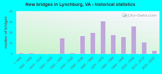
- New bridges - historical statistics
- 1Before 1900
- 11900-1909
- 151930-1939
- 11940-1949
- 171950-1959
- 201960-1969
- 311970-1979
- 181980-1989
- 161990-1999
- 262000-2009
- 112010-2019
- 32020-2022
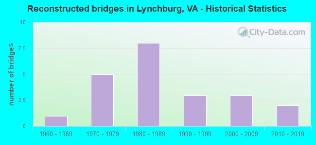
- Reconstructed bridges - Historical Statistics
- 11960-1969
- 51970-1979
- 81980-1989
- 31990-1999
- 32000-2009
- 22010-2019
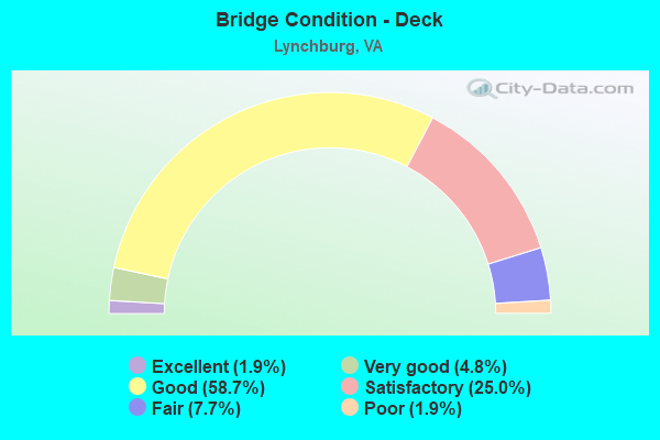
- Bridge Condition - Deck
- 1.9%Excellent
- 4.8%Very good
- 58.7%Good
- 25.0%Satisfactory
- 7.7%Fair
- 1.9%Poor
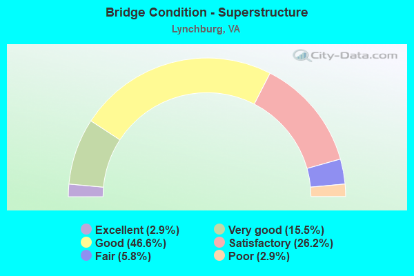
- Bridge Condition - Superstructure
- 2.9%Excellent
- 15.5%Very good
- 46.6%Good
- 26.2%Satisfactory
- 5.8%Fair
- 2.9%Poor
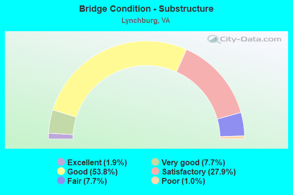
- Bridge Condition - Substructure
- 1.9%Excellent
- 7.7%Very good
- 53.8%Good
- 27.9%Satisfactory
- 7.7%Fair
- 1.0%Poor
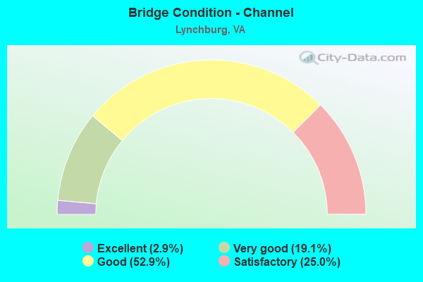
- Bridge Condition - Channel
- 2.9%Excellent
- 19.1%Very good
- 52.9%Good
- 25.0%Satisfactory
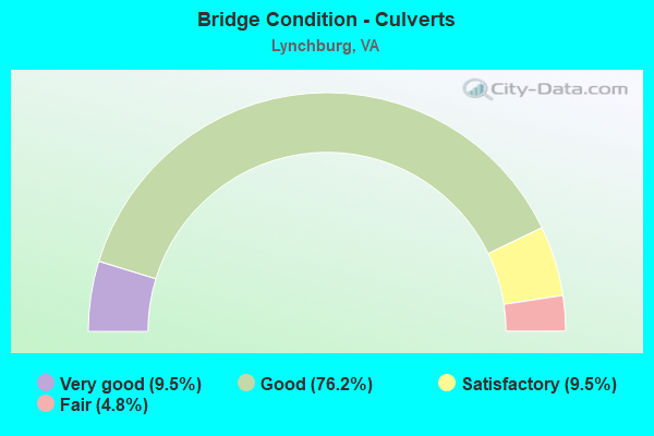
- Bridge Condition - Culverts
- 9.5%Very good
- 76.2%Good
- 9.5%Satisfactory
- 4.8%Fair
Find on map >> Show street view
Structure Number: 20601, Location: 0269501 001729 A (Lat: 37.419058, Lng: -79.146739), Route carried "on" structure: Alternate US 501, Year Built: 1974, Year Reconstructed: 2011, Status: Open, Structure Length: 26.97m (88.48ft), Average Daily Traffic: 12,464 (year 2020), Truck Traffic: 4%, Average Future Daily Traffic: 13,710 (year 2040), Design Load: HS 20+Mod, Features Intersected: Blackwater Creek, Facility Carried by Structure: Rivermont Avenue
Minimum Vertical Clearance: 30+ m (98+ ft), Kilometerpoint: 4.344, Lanes on structure: 4, Owner: City or Municipal Highway Agency, Approaching Roadway Width: 17.1m (56.1ft), Skew: 20 degrees, Material/Design: Steel, Design/Construction: Stringer/Multi-beam, Number Of Spans In Main Unit: 7, Length of Maximum Span: 45.7m (149.9ft), Curb or Sidewalk Widths: Left: 1.5m (4.9ft), Right: 1.5m (4.9ft), Curb-To-Curb Width: 17.1m (56.1ft), Out-to-Out Width: 21.0m (68.9ft)
Condition: Deck: Satisfactory, Superstructure: Satisfactory, Substructure: Satisfactory, Channel: Satisfactory, Operating Rating: 36.3 metric tons, Method Used To Determine Operating Rating: Load and Resistance Factor (LRFR), Inventory Rating: 28.1 metric tons, Method Used To Determine Inventory Rating: Load and Resistance Factor (LRFR), Structural Evaluation: Equal to present minimum criteria, Deck Geometry: Somewhat better than minimum adequacy, Waterway Adequacy: Better than present minimum criteria, Approach Roadway Alignment: Somewhat better than minimum adequacy, Length Of Structure Improvement: 33.71m (110.60ft), Designated Inspection Frequency: Every 24 months, Inspection Date: March 2020, Bridge Improvement Cost: $9,666,000, Roadway Improvement Cost: $966,000, Total Project Cost: $14,499,000 ( Estimate for 2014), Deck Structure Type: Concrete Cast-file-Place, Wearing Surface/Protective System: Wearing Surface: Monolithic Concrete
Find on map >> Show street view
Structure Number: 20602, Location: 0095460 0000CAMPB C (Lat: 37.370511, Lng: -79.115683), Route carried "on" structure: US 501, Year Built: 1932, Status: Open, Structure Length: 0.67m (2.20ft), Average Daily Traffic: 10,258 (year 2020), Truck Traffic: 3%, Average Future Daily Traffic: 11,177 (year 2040), Features Intersected: Little Oppossum Creek
Minimum Vertical Clearance: 30+ m (98+ ft), Kilometerpoint: 15.462, Lanes on structure: 2, Owner: City or Municipal Highway Agency, Approaching Roadway Width: 13.4m (44.0ft), Material/Design: Concrete, Design/Construction: Slab, Number Of Spans In Main Unit: 1, Length of Maximum Span: 6.7m (22.0ft), Curb or Sidewalk Widths: Left: 0.6m (2.0ft), Right: 0.6m (2.0ft), Curb-To-Curb Width: 13.4m (44.0ft), Out-to-Out Width: 15.2m (49.9ft)
Condition: Deck: Satisfactory, Superstructure: Satisfactory, Substructure: Good, Channel: Good, Operating Rating: 39.9 metric tons, Method Used To Determine Operating Rating: Load Factor (LF), Inventory Rating: 23.6 metric tons, Method Used To Determine Inventory Rating: Load Factor (LF), Structural Evaluation: Somewhat better than minimum adequacy, Deck Geometry: Equal to present minimum criteria, Waterway Adequacy: Better than present minimum criteria, Approach Roadway Alignment: Equal to present minimum criteria, Length Of Structure Improvement: 1.28m (4.20ft), Designated Inspection Frequency: Every 24 months, Inspection Date: November 2020, Bridge Improvement Cost: $367,000, Roadway Improvement Cost: $37,000, Total Project Cost: $551,000 ( Estimate for 2014), Deck Structure Type: Concrete Cast-file-Place, Wearing Surface/Protective System: Wearing Surface: Bituminous
Find on map >> Show street view
Structure Number: 20603, Location: .06 Rt F906 / .69 Rt 128 (Lat: 37.356181, Lng: -79.169594), Route carried "on" structure: County highway 670, Year Built: 1979, Status: Open, Structure Length: 7.43m (24.38ft), Average Daily Traffic: 8,664 (year 2020), Truck Traffic: 2%, Average Future Daily Traffic: 9,530 (year 2040), Design Load: HS 20+Mod, Features Intersected: 29/460 Bypass, Facility Carried by Structure: Candlers Mtn. Rd.
Minimum Vertical Clearance: 30+ m (98+ ft), Kilometerpoint: 1.834, Lanes on structure: 2, Lanes under structure: 4, Owner: State Highway Agency, Approaching Roadway Width: 8.5m (27.9ft), Skew: 3 degrees, Material/Design: Steel, Design/Construction: Stringer/Multi-beam, Number Of Spans In Main Unit: 3, Length of Maximum Span: 30.2m (99.1ft), Curb-To-Curb Width: 10.4m (34.1ft), Out-to-Out Width: 11.6m (38.1ft)
Condition: Deck: Good, Superstructure: Satisfactory, Substructure: Satisfactory, Operating Rating: 87.1 metric tons, Method Used To Determine Operating Rating: Load and Resistance Factor (LRFR), Inventory Rating: 67.1 metric tons, Method Used To Determine Inventory Rating: Load and Resistance Factor (LRFR), Structural Evaluation: Equal to present minimum criteria, Deck Geometry: Meets minimum limits, Underclear: High priority of corrective action, Approach Roadway Alignment: Equal to present minimum criteria, Designated Inspection Frequency: Every 24 months, Inspection Date: June 2020, Deck Structure Type: Concrete Cast-file-Place, Wearing Surface/Protective System: Wearing Surface: Epoxy Overlay, Membrane: Epoxy, Deck Protection: Epoxy Coated Reinforcing
Find on map >> Show street view
Structure Number: 23209, Location: 2.0-Rt 665/1.30-Rt 662 (Lat: 37.355506, Lng: -79.084031), Route carried "on" structure: City street 660, Year Built: 1991, Status: Open, Structure Length: 4.96m (16.27ft), Average Daily Traffic: 606 (year 2020), Truck Traffic: 2%, Average Future Daily Traffic: 667 (year 2040), Design Load: HS 20+Mod, Features Intersected: NS Railway, Facility Carried by Structure: Eastbrook Road
Minimum Vertical Clearance: 30+ m (98+ ft), Kilometerpoint: 4.505, Lanes on structure: 2, Owner: State Highway Agency, Approaching Roadway Width: 7.0m (23.0ft), Skew: 4 degrees, Material/Design: Steel, Design/Construction: Stringer/Multi-beam, Number Of Spans In Main Unit: 3, Length of Maximum Span: 24.4m (80.1ft), Curb-To-Curb Width: 7.9m (25.9ft), Out-to-Out Width: 8.9m (29.2ft)
Condition: Deck: Good, Superstructure: Very good, Substructure: Good, Operating Rating: 89.8 metric tons, Method Used To Determine Operating Rating: Load and Resistance Factor (LRFR), Inventory Rating: 85.3 metric tons, Method Used To Determine Inventory Rating: Load and Resistance Factor (LRFR), Structural Evaluation: Better than present minimum criteria, Underclear: Equal to present minimum criteria, Approach Roadway Alignment: Equal to present desirable criteria, Designated Inspection Frequency: Every 24 months, Inspection Date: January 2021, Deck Structure Type: Concrete Cast-file-Place, Wearing Surface/Protective System: Wearing Surface: Epoxy Overlay, Deck Protection: Epoxy Coated Reinforcing
Find on map >> Show street view
Structure Number: 23307, Location: .05 Sheff Dr./ .05 Edw.Av (Lat: 37.370006, Lng: -79.187675), Route carried "on" structure: City street , Year Built: 1991, Status: Open, Structure Length: 4.34m (14.24ft), Average Daily Traffic: 500 (year 2011), Truck Traffic: 7%, Average Future Daily Traffic: 1,500 (year 2034), Design Load: HS 20+Mod, Features Intersected: NS Railway, Facility Carried by Structure: Autumn Drive
Minimum Vertical Clearance: 30+ m (98+ ft), Kilometerpoint: 0.000, Lanes on structure: 2, Owner: City or Municipal Highway Agency, Approaching Roadway Width: 8.5m (27.9ft), Skew: 1 degrees, Material/Design: Steel continuous, Design/Construction: Stringer/Multi-beam, Number Of Spans In Main Unit: 3, Length of Maximum Span: 18.3m (60.0ft), Curb or Sidewalk Widths: Left: 0.0m, Right: 1.5m (4.9ft), Curb-To-Curb Width: 8.5m (27.9ft), Out-to-Out Width: 10.9m (35.8ft)
Condition: Deck: Good, Superstructure: Satisfactory, Substructure: Good, Operating Rating: 99.8 metric tons, Method Used To Determine Operating Rating: Load and Resistance Factor (LRFR), Inventory Rating: 80.7 metric tons, Method Used To Determine Inventory Rating: Load and Resistance Factor (LRFR), Structural Evaluation: Equal to present minimum criteria, Deck Geometry: Somewhat better than minimum adequacy, Underclear: Better than present minimum criteria, Approach Roadway Alignment: Better than present minimum criteria, Designated Inspection Frequency: Every 12 months, Inspection Date: October 2021, Deck Structure Type: Concrete Cast-file-Place, Wearing Surface/Protective System: Wearing Surface: Monolithic Concrete, Deck Protection: Epoxy Coated Reinforcing
Find on map >> Show street view
Structure Number: 24098, Location: 0025CAMP AVE 0008MB SCHOO (Lat: 37.390997, Lng: -79.142411), Route carried "on" structure: City street , Year Built: 1994, Status: Open, Structure Length: 4.88m (16.01ft), Average Daily Traffic: 210 (year 2011), Average Future Daily Traffic: 319 (year 2035), Design Load: HS 20, Features Intersected: SEABURY AV O NS RAILWAY, Facility Carried by Structure: ROUTE 0000
Minimum Vertical Clearance: 30+ m (98+ ft), Kilometerpoint: 0.000, Lanes on structure: 2, Owner: City or Municipal Highway Agency, Approaching Roadway Width: 9.1m (29.9ft), Skew: 1 degrees, Material/Design: Steel continuous, Design/Construction: Stringer/Multi-beam, Number Of Spans In Main Unit: 3, Length of Maximum Span: 21.3m (69.9ft), Curb or Sidewalk Widths: Left: 1.5m (4.9ft), Right: 1.5m (4.9ft), Curb-To-Curb Width: 9.1m (29.9ft), Out-to-Out Width: 12.8m (42.0ft)
Condition: Deck: Good, Superstructure: Very good, Substructure: Good, Operating Rating: 68.0 metric tons, Method Used To Determine Operating Rating: Load and Resistance Factor (LRFR), Inventory Rating: 52.6 metric tons, Method Used To Determine Inventory Rating: Load and Resistance Factor (LRFR), Structural Evaluation: Better than present minimum criteria, Deck Geometry: Equal to present minimum criteria, Underclear: Superior to present desirable criteria, Approach Roadway Alignment: Superior to present desirable criteria, Designated Inspection Frequency: Every 24 months, Inspection Date: December 2020, Deck Structure Type: Concrete Cast-file-Place, Wearing Surface/Protective System: Wearing Surface: Monolithic Concrete
Find on map >> Show street view
Structure Number: 24859, Location: 0.04 LCR - 0.56 OGMR (Lat: 37.364258, Lng: -79.238525), Route carried "on" structure: City street , Year Built: 1997, Status: Open, Structure Length: 1.16m (3.81ft), Average Daily Traffic: 400 (year 2017), Truck Traffic: 1%, Average Future Daily Traffic: 550 (year 2036), Design Load: HS 20, Features Intersected: Tomahawk Creek, Facility Carried by Structure: Robin Drive
Minimum Vertical Clearance: 30+ m (98+ ft), Kilometerpoint: 0.000, Lanes on structure: 2, Owner: City or Municipal Highway Agency, Approaching Roadway Width: 9.8m (32.2ft), Material/Design: Concrete, Design/Construction: Culvert, Number Of Spans In Main Unit: 3, Length of Maximum Span: 3.7m (12.1ft)
Condition: Channel: Good, Culverts: Good, Operating Rating: 69.9 metric tons, Method Used To Determine Operating Rating: Load Factor (LF), Inventory Rating: 41.7 metric tons, Method Used To Determine Inventory Rating: Load Factor (LF), Structural Evaluation: Better than present minimum criteria, Waterway Adequacy: Better than present minimum criteria, Approach Roadway Alignment: Equal to present desirable criteria, Designated Inspection Frequency: Every 24 months, Inspection Date: Febuary 2021
Find on map >> Show street view
Structure Number: 25035, Location: 0.01-Rt677/0.29-Rt634 (Lat: 37.362158, Lng: -79.125150), Route carried "on" structure: County highway 664, Year Built: 1997, Status: Open, Structure Length: 3.63m (11.91ft), Average Daily Traffic: 609 (year 2020), Truck Traffic: 2%, Average Future Daily Traffic: 693 (year 2040), Features Intersected: NS Railway, Facility Carried by Structure: Old Rustburg Rd.
Minimum Vertical Clearance: 30+ m (98+ ft), Kilometerpoint: 0.000, Lanes on structure: 2, Owner: State Highway Agency, Approaching Roadway Width: 11.0m (36.1ft), Material/Design: Steel, Design/Construction: Stringer/Multi-beam, Number Of Spans In Main Unit: 3, Length of Maximum Span: 17.4m (57.1ft), Curb or Sidewalk Widths: Left: 0.5m (1.6ft), Right: 0.5m (1.6ft), Curb-To-Curb Width: 9.1m (29.9ft), Out-to-Out Width: 10.1m (33.1ft)
Condition: Deck: Good, Superstructure: Very good, Substructure: Good, Operating Rating: 78.0 metric tons, Method Used To Determine Operating Rating: Load and Resistance Factor (LRFR), Inventory Rating: 59.9 metric tons, Method Used To Determine Inventory Rating: Load and Resistance Factor (LRFR), Structural Evaluation: Better than present minimum criteria, Deck Geometry: Equal to present minimum criteria, Underclear: Superior to present desirable criteria, Approach Roadway Alignment: Superior to present desirable criteria, Designated Inspection Frequency: Every 24 months, Inspection Date: June 2021, Deck Structure Type: Concrete Cast-file-Place, Wearing Surface/Protective System: Deck Protection: Epoxy Coated Reinforcing
Find on map >> Show street view
Structure Number: 25697, Location: .00-Amherst /0.00Campbell (Lat: 37.394583, Lng: -79.088747), Route carried "on" structure: US 29, Year Built: 2001, Status: Open, Structure Length: 72.85m (239.01ft), Average Daily Traffic: 8,649 (year 2020), Truck Traffic: 9%, Average Future Daily Traffic: 12,109 (year 2040), Design Load: HS 20+Mod, Features Intersected: James River & CSX Rwy.
Minimum Vertical Clearance: 30+ m (98+ ft), Kilometerpoint: 121.158, Lanes on structure: 2, Base Highway Network: Yes, Owner: State Highway Agency, Approaching Roadway Width: 11.6m (38.1ft), Material/Design: Steel continuous, Design/Construction: Stringer/Multi-beam, Number Of Spans In Main Unit: 14, Length of Maximum Span: 52.4m (171.9ft), Curb-To-Curb Width: 11.6m (38.1ft), Out-to-Out Width: 12.2m (40.0ft)
Condition: Deck: Good, Superstructure: Good, Substructure: Good, Channel: Good, Operating Rating: 72.6 metric tons, Method Used To Determine Operating Rating: Load and Resistance Factor (LRFR), Inventory Rating: 55.3 metric tons, Method Used To Determine Inventory Rating: Load and Resistance Factor (LRFR), Structural Evaluation: Better than present minimum criteria, Deck Geometry: Equal to present minimum criteria, Waterway Adequacy: Superior to present desirable criteria, Approach Roadway Alignment: Equal to present desirable criteria, Designated Inspection Frequency: Every 24 months, Inspection Date: November 2020, Deck Structure Type: Concrete Cast-file-Place, Wearing Surface/Protective System: Wearing Surface: Epoxy Overlay, Deck Protection: Epoxy Coated Reinforcing
Find on map >> Show street view
Structure Number: 25698, Location: .00-Camp. CL/.00-Amh CL (Lat: 37.394850, Lng: -79.088967), Route carried "on" structure: US 29, Year Built: 2001, Status: Open, Structure Length: 70.07m (229.89ft), Average Daily Traffic: 8,649 (year 2020), Truck Traffic: 9%, Average Future Daily Traffic: 12,109 (year 2040), Design Load: HS 20+Mod, Features Intersected: James River & CSX Rwy.
Minimum Vertical Clearance: 30+ m (98+ ft), Kilometerpoint: 121.158, Lanes on structure: 2, Base Highway Network: Yes, Owner: State Highway Agency, Approaching Roadway Width: 11.6m (38.1ft), Skew: 10 degrees, Material/Design: Steel continuous, Design/Construction: Stringer/Multi-beam, Number Of Spans In Main Unit: 15, Length of Maximum Span: 52.4m (171.9ft), Curb-To-Curb Width: 11.6m (38.1ft), Out-to-Out Width: 12.2m (40.0ft)
Condition: Deck: Good, Superstructure: Good, Substructure: Good, Channel: Very good, Operating Rating: 74.4 metric tons, Method Used To Determine Operating Rating: Load and Resistance Factor (LRFR), Inventory Rating: 57.2 metric tons, Method Used To Determine Inventory Rating: Load and Resistance Factor (LRFR), Structural Evaluation: Better than present minimum criteria, Deck Geometry: Equal to present minimum criteria, Underclear: Superior to present desirable criteria, Waterway Adequacy: Superior to present desirable criteria, Approach Roadway Alignment: Equal to present desirable criteria, Designated Inspection Frequency: Every 24 months, Inspection Date: November 2020, Deck Structure Type: Concrete Cast-file-Place, Wearing Surface/Protective System: Wearing Surface: Epoxy Overlay, Deck Protection: Epoxy Coated Reinforcing
Find on map >> Show street view
Structure Number: 2576, Location: .04 Selene St / .32 Hydro (Lat: 37.447625, Lng: -79.179764), Route carried "on" structure: City street , Year Built: 1998, Status: Open, Structure Length: 1.07m (3.51ft), Average Daily Traffic: 250 (year 2014), Average Future Daily Traffic: 350 (year 2036), Design Load: HS 20, Features Intersected: Pigeon Creek, Facility Carried by Structure: Reusens Road
Minimum Vertical Clearance: 30+ m (98+ ft), Kilometerpoint: 0.000, Lanes on structure: 2, Owner: City or Municipal Highway Agency, Approaching Roadway Width: 8.2m (26.9ft), Skew: 5 degrees, Material/Design: Concrete, Design/Construction: Culvert, Number Of Spans In Main Unit: 2, Length of Maximum Span: 3.0m (9.8ft)
Condition: Channel: Good, Culverts: Good, Operating Rating: 88.9 metric tons, Method Used To Determine Operating Rating: Load Factor (LF), Inventory Rating: 53.5 metric tons, Method Used To Determine Inventory Rating: Load Factor (LF), Structural Evaluation: Better than present minimum criteria, Waterway Adequacy: Better than present minimum criteria, Approach Roadway Alignment: Equal to present minimum criteria, Designated Inspection Frequency: Every 24 months, Inspection Date: Febuary 2021
Find on map >> Show street view
Structure Number: 25918, Location: .10-Lynch CL/0.90-Rt 726 (Lat: 37.385394, Lng: -79.091756), Route carried "on" structure: US 460, Year Built: 2003, Status: Open, Structure Length: 26.12m (85.70ft), Average Daily Traffic: 12,337 (year 2020), Truck Traffic: 6%, Average Future Daily Traffic: 17,273 (year 2040), Design Load: HS 20+Mod, Features Intersected: 29 Bp Lt Opossum Crk
Minimum Vertical Clearance: 30+ m (98+ ft), Kilometerpoint: 336.378, Lanes on structure: 2, Lanes under structure: 2, Base Highway Network: Yes, Owner: State Highway Agency, Approaching Roadway Width: 14.6m (47.9ft), Material/Design: Steel continuous, Design/Construction: Stringer/Multi-beam, Number Of Spans In Main Unit: 6, Length of Maximum Span: 55.8m (183.1ft), Curb-To-Curb Width: 15.2m (49.9ft), Out-to-Out Width: 16.2m (53.1ft)
Condition: Deck: Good, Superstructure: Good, Substructure: Good, Channel: Very good, Operating Rating: 60.8 metric tons, Method Used To Determine Operating Rating: Load and Resistance Factor (LRFR), Inventory Rating: 47.2 metric tons, Method Used To Determine Inventory Rating: Load and Resistance Factor (LRFR), Structural Evaluation: Better than present minimum criteria, Deck Geometry: Superior to present desirable criteria, Underclear: Better than present minimum criteria, Approach Roadway Alignment: Equal to present desirable criteria, Designated Inspection Frequency: Every 24 months, Inspection Date: January 2021, Deck Structure Type: Concrete Cast-file-Place, Wearing Surface/Protective System: Wearing Surface: Epoxy Overlay, Deck Protection: Epoxy Coated Reinforcing
Find on map >> Show street view
Structure Number: 25919, Location: .10-Lynch CL/7.10-Rt.24 (Lat: 37.385600, Lng: -79.091467), Route carried "on" structure: US 460, Year Built: 2003, Status: Open, Structure Length: 24.99m (81.99ft), Average Daily Traffic: 12,337 (year 2020), Truck Traffic: 7%, Average Future Daily Traffic: 17,273 (year 2040), Design Load: HS 20+Mod, Features Intersected: 29 Bp Lt Opossum Crk
Minimum Vertical Clearance: 30+ m (98+ ft), Kilometerpoint: 336.361, Lanes on structure: 2, Lanes under structure: 2, Base Highway Network: Yes, Owner: State Highway Agency, Approaching Roadway Width: 9.1m (29.9ft), Material/Design: Steel continuous, Design/Construction: Stringer/Multi-beam, Number Of Spans In Main Unit: 5, Length of Maximum Span: 55.8m (183.1ft), Curb-To-Curb Width: 11.6m (38.1ft), Out-to-Out Width: 12.6m (41.3ft)
Condition: Deck: Good, Superstructure: Good, Substructure: Good, Channel: Very good, Operating Rating: 80.7 metric tons, Method Used To Determine Operating Rating: Load and Resistance Factor (LRFR), Inventory Rating: 61.7 metric tons, Method Used To Determine Inventory Rating: Load and Resistance Factor (LRFR), Structural Evaluation: Better than present minimum criteria, Deck Geometry: Better than present minimum criteria, Underclear: Better than present minimum criteria, Approach Roadway Alignment: Equal to present desirable criteria, Designated Inspection Frequency: Every 24 months, Inspection Date: Febuary 2021, Deck Structure Type: Concrete Cast-file-Place, Wearing Surface/Protective System: Wearing Surface: Epoxy Overlay, Deck Protection: Epoxy Coated Reinforcing
Find on map >> Show street view
Structure Number: 25921, Location: .70-Rt.460 E/.50-Amh. CL (Lat: 37.384531, Lng: -79.090181), Route carried "on" structure: Bypass US 29, Year Built: 2003, Status: Open, Structure Length: 13.78m (45.21ft), Average Daily Traffic: 17,298 (year 2020), Truck Traffic: 11%, Average Future Daily Traffic: 22,657 (year 2040), Design Load: HS 20+Mod, Features Intersected: Little Opossum Creek
Minimum Vertical Clearance: 6.52m (21.39ft), Kilometerpoint: 120.031, Lanes on structure: 2, Base Highway Network: Yes, Owner: State Highway Agency, Approaching Roadway Width: 15.2m (49.9ft), Skew: 30 degrees, Material/Design: Steel continuous, Design/Construction: Stringer/Multi-beam, Number Of Spans In Main Unit: 4, Length of Maximum Span: 38.1m (125.0ft), Curb-To-Curb Width: 17.0m (55.8ft), Out-to-Out Width: 18.7m (61.4ft)
Condition: Deck: Good, Superstructure: Good, Substructure: Good, Channel: Good, Operating Rating: 55.3 metric tons, Method Used To Determine Operating Rating: Load and Resistance Factor (LRFR), Inventory Rating: 42.6 metric tons, Method Used To Determine Inventory Rating: Load and Resistance Factor (LRFR), Structural Evaluation: Better than present minimum criteria, Deck Geometry: Superior to present desirable criteria, Waterway Adequacy: Superior to present desirable criteria, Approach Roadway Alignment: Equal to present desirable criteria, Designated Inspection Frequency: Every 24 months, Inspection Date: July 2021, Deck Structure Type: Concrete Cast-file-Place, Wearing Surface/Protective System: Wearing Surface: Epoxy Overlay, Deck Protection: Epoxy Coated Reinforcing
Find on map >> Show street view
Structure Number: 25922, Location: 0.20-Rt.460 E/.20-Rt.29 N (Lat: 37.388411, Lng: -79.086394), Route carried "on" structure: Ramp US 29, Year Built: 2003, Status: Open, Structure Length: 9.88m (32.41ft), Average Daily Traffic: 4,250 (year 2020), Truck Traffic: 9%, Average Future Daily Traffic: 5,500 (year 2036), Design Load: HS 20+Mod, Features Intersected: Little Opossum Creek
Minimum Vertical Clearance: 30+ m (98+ ft), Kilometerpoint: 0.000, Lanes on structure: 1, Base Highway Network: Yes, Owner: State Highway Agency, Approaching Roadway Width: 8.5m (27.9ft), Material/Design: Prestressed concrete continuous, Design/Construction: Stringer/Multi-beam, Number Of Spans In Main Unit: 4, Length of Maximum Span: 25.6m (84.0ft), Curb-To-Curb Width: 9.1m (29.9ft), Out-to-Out Width: 10.1m (33.1ft)
Condition: Deck: Good, Superstructure: Good, Substructure: Good, Channel: Very good, Operating Rating: 59.9 metric tons, Method Used To Determine Operating Rating: Load and Resistance Factor (LRFR), Inventory Rating: 46.3 metric tons, Method Used To Determine Inventory Rating: Load and Resistance Factor (LRFR), Structural Evaluation: Better than present minimum criteria, Deck Geometry: Superior to present desirable criteria, Waterway Adequacy: Superior to present desirable criteria, Approach Roadway Alignment: Equal to present desirable criteria, Designated Inspection Frequency: Every 24 months, Inspection Date: July 2021, Deck Structure Type: Concrete Cast-file-Place, Wearing Surface/Protective System: Wearing Surface: Epoxy Overlay, Deck Protection: Epoxy Coated Reinforcing
Find on map >> Show street view
Structure Number: 25923, Location: .90-ECL Lyn/6.27-Rt. 24 (Lat: 37.386203, Lng: -79.080094), Route carried "on" structure: US 460, Year Built: 2003, Status: Open, Structure Length: 12.50m (41.01ft), Average Daily Traffic: 12,337 (year 2020), Truck Traffic: 7%, Average Future Daily Traffic: 17,273 (year 2040), Design Load: HL 93, Features Intersected: Little Opossum Creek, Facility Carried by Structure: Richmond Hwy
Minimum Vertical Clearance: 30+ m (98+ ft), Kilometerpoint: 337.391, Lanes on structure: 2, Base Highway Network: Yes, Owner: State Highway Agency, Approaching Roadway Width: 12.2m (40.0ft), Material/Design: Steel continuous, Design/Construction: Stringer/Multi-beam, Number Of Spans In Main Unit: 4, Length of Maximum Span: 38.1m (125.0ft), Curb-To-Curb Width: 11.6m (38.1ft), Out-to-Out Width: 13.2m (43.3ft)
Condition: Deck: Good, Superstructure: Good, Substructure: Good, Channel: Good, Operating Rating: 65.3 metric tons, Method Used To Determine Operating Rating: Load and Resistance Factor (LRFR), Inventory Rating: 49.9 metric tons, Method Used To Determine Inventory Rating: Load and Resistance Factor (LRFR), Structural Evaluation: Better than present minimum criteria, Deck Geometry: Better than present minimum criteria, Waterway Adequacy: Equal to present desirable criteria, Approach Roadway Alignment: Equal to present desirable criteria, Designated Inspection Frequency: Every 24 months, Inspection Date: Febuary 2021, Deck Structure Type: Concrete Cast-file-Place, Wearing Surface/Protective System: Wearing Surface: Epoxy Overlay, Deck Protection: Epoxy Coated Reinforcing
Find on map >> Show street view
Structure Number: 25924, Location: 0.01 to 29 - 6.27 to 24 (Lat: 37.386392, Lng: -79.080311), Route carried "on" structure: US 460, Year Built: 2003, Status: Open, Structure Length: 10.67m (35.01ft), Average Daily Traffic: 12,337 (year 2020), Truck Traffic: 7%, Average Future Daily Traffic: 17,273 (year 2040), Design Load: H 15, Features Intersected: Little Opossum Creek, Facility Carried by Structure: Richmond Highway
Minimum Vertical Clearance: 30+ m (98+ ft), Kilometerpoint: 337.391, Lanes on structure: 2, Base Highway Network: Yes, Owner: State Highway Agency, Approaching Roadway Width: 9.8m (32.2ft), Material/Design: Steel continuous, Design/Construction: Stringer/Multi-beam, Number Of Spans In Main Unit: 3, Length of Maximum Span: 39.6m (129.9ft), Curb-To-Curb Width: 12.2m (40.0ft), Out-to-Out Width: 13.2m (43.3ft)
Condition: Deck: Good, Superstructure: Good, Substructure: Good, Channel: Good, Operating Rating: 54.4 metric tons, Method Used To Determine Operating Rating: Load and Resistance Factor (LRFR), Inventory Rating: 41.7 metric tons, Method Used To Determine Inventory Rating: Load and Resistance Factor (LRFR), Structural Evaluation: Better than present minimum criteria, Deck Geometry: Better than present minimum criteria, Waterway Adequacy: Superior to present desirable criteria, Approach Roadway Alignment: Equal to present desirable criteria, Designated Inspection Frequency: Every 24 months, Inspection Date: Febuary 2021, Deck Structure Type: Concrete Cast-file-Place, Wearing Surface/Protective System: Wearing Surface: Epoxy Overlay, Deck Protection: Epoxy Coated Reinforcing
Find on map >> Show street view
Structure Number: 25925, Location: .20-Rt460/1.20-Amherst CL (Lat: 37.382625, Lng: -79.093919), Route carried "on" structure: Ramp US 29, Year Built: 2003, Status: Open, Structure Length: 11.19m (36.71ft), Average Daily Traffic: 17,298 (year 2020), Truck Traffic: 7%, Average Future Daily Traffic: 22,657 (year 2040), Design Load: HS 20+Mod, Features Intersected: Little Opossum Creek
Minimum Vertical Clearance: 30+ m (98+ ft), Kilometerpoint: 119.436, Lanes on structure: 2, Base Highway Network: Yes, Owner: State Highway Agency, Approaching Roadway Width: 9.1m (29.9ft), Skew: 30 degrees, Material/Design: Steel continuous, Design/Construction: Stringer/Multi-beam, Number Of Spans In Main Unit: 3, Length of Maximum Span: 41.1m (134.8ft), Curb-To-Curb Width: 9.1m (29.9ft), Out-to-Out Width: 20.0m (65.6ft)
Condition: Deck: Good, Superstructure: Good, Substructure: Good, Channel: Good, Operating Rating: 72.6 metric tons, Method Used To Determine Operating Rating: Load and Resistance Factor (LRFR), Inventory Rating: 55.3 metric tons, Method Used To Determine Inventory Rating: Load and Resistance Factor (LRFR), Structural Evaluation: Better than present minimum criteria, Deck Geometry: Meets minimum limits, Waterway Adequacy: Superior to present desirable criteria, Approach Roadway Alignment: Equal to present desirable criteria, Length Of Structure Improvement: 12.74m (41.80ft), Designated Inspection Frequency: Every 24 months, Inspection Date: November 2021, Bridge Improvement Cost: $3,653,000, Roadway Improvement Cost: $365,000, Total Project Cost: $5,480,000 ( Estimate for 2015), Deck Structure Type: Concrete Cast-file-Place, Wearing Surface/Protective System: Wearing Surface: Epoxy Overlay, Deck Protection: Epoxy Coated Reinforcing
Find on map >> Show street view
Structure Number: 26094, Location: 1.55-RTE 659;0.70-RTE 621 (Lat: 37.403361, Lng: -79.261194), Route carried "on" structure: County highway 660, Year Built: 2006, Status: Open, Structure Length: 2.35m (7.71ft), Average Daily Traffic: 3,224 (year 2020), Truck Traffic: 1%, Average Future Daily Traffic: 4,514 (year 2040), Features Intersected: IVY CREEK, Facility Carried by Structure: HAWKINS MILL ROAD
Minimum Vertical Clearance: 30+ m (98+ ft), Kilometerpoint: 1.046, Lanes on structure: 2, Owner: State Highway Agency, Approaching Roadway Width: 12.8m (42.0ft), Skew: 3 degrees, Material/Design: Prestressed concrete, Design/Construction: Stringer/Multi-beam, Number Of Spans In Main Unit: 1, Length of Maximum Span: 22.9m (75.1ft), Curb-To-Curb Width: 12.2m (40.0ft), Out-to-Out Width: 13.0m (42.7ft)
Condition: Deck: Satisfactory, Superstructure: Very good, Substructure: Good, Channel: Very good, Operating Rating: 99.8 metric tons, Method Used To Determine Operating Rating: Load and Resistance Factor (LRFR), Inventory Rating: 77.1 metric tons, Method Used To Determine Inventory Rating: Load and Resistance Factor (LRFR), Structural Evaluation: Better than present minimum criteria, Deck Geometry: Equal to present minimum criteria, Waterway Adequacy: Superior to present desirable criteria, Approach Roadway Alignment: Equal to present desirable criteria, Length Of Structure Improvement: 2.41m (7.91ft), Designated Inspection Frequency: Every 24 months, Inspection Date: Febuary 2021, Bridge Improvement Cost: $1,604,000, Roadway Improvement Cost: $401,000, Total Project Cost: $5,131,000 ( Estimate for 2021), Deck Structure Type: Concrete Cast-file-Place, Wearing Surface/Protective System: Deck Protection: Epoxy Coated Reinforcing
Find on map >> Show street view
Structure Number: 26206, Location: 0.98 Rt 501; 0.02-Rt 657 (Lat: 37.489361, Lng: -79.299175), Route carried "on" structure: County highway 651, Year Built: 2000, Status: Open, Structure Length: 0.79m (2.59ft), Average Daily Traffic: 75 (year 2019), Average Future Daily Traffic: 106 (year 2040), Design Load: HS 20+Mod, Features Intersected: Cove Creek
Minimum Vertical Clearance: 30+ m (98+ ft), Kilometerpoint: 0.032, Lanes on structure: 2, Owner: State Highway Agency, Approaching Roadway Width: 4.0m (13.1ft), Material/Design: Concrete, Design/Construction: Culvert, Number Of Spans In Main Unit: 3, Length of Maximum Span: 2.4m (7.9ft), Curb-To-Curb Width: 7.6m (24.9ft), Out-to-Out Width: 7.6m (24.9ft)
Condition: Channel: Good, Culverts: Good, Operating Rating: 59.9 metric tons, Method Used To Determine Operating Rating: Load Factor (LF), Inventory Rating: 36.3 metric tons, Method Used To Determine Inventory Rating: Load Factor (LF), Structural Evaluation: Better than present minimum criteria, Deck Geometry: Equal to present minimum criteria, Waterway Adequacy: Equal to present minimum criteria, Approach Roadway Alignment: Equal to present desirable criteria, Designated Inspection Frequency: Every 24 months, Inspection Date: March 2021
Find on map >> Show street view
Structure Number: 2625, Location: 1.10-Rt 665/2.20-Rt 662 (Lat: 37.359119, Lng: -79.090217), Route carried "on" structure: County highway 660, Year Built: 1999, Status: Open, Structure Length: 1.04m (3.41ft), Average Daily Traffic: 518 (year 2020), Truck Traffic: 2%, Average Future Daily Traffic: 570 (year 2040), Design Load: HS 20+Mod, Features Intersected: Opossum Creek, Facility Carried by Structure: Eastbrook Road
Minimum Vertical Clearance: 30+ m (98+ ft), Kilometerpoint: 3.057, Lanes on structure: 2, Owner: State Highway Agency, Approaching Roadway Width: 6.7m (22.0ft), Material/Design: Concrete, Design/Construction: Frame, Number Of Spans In Main Unit: 1, Length of Maximum Span: 9.8m (32.2ft), Curb-To-Curb Width: 10.1m (33.1ft), Out-to-Out Width: 11.6m (38.1ft)
Condition: Deck: Good, Superstructure: Good, Substructure: Good, Channel: Good, Operating Rating: 96.2 metric tons, Method Used To Determine Operating Rating: Load and Resistance Factor (LRFR), Inventory Rating: 73.5 metric tons, Method Used To Determine Inventory Rating: Load and Resistance Factor (LRFR), Structural Evaluation: Better than present minimum criteria, Deck Geometry: Equal to present minimum criteria, Waterway Adequacy: Better than present minimum criteria, Approach Roadway Alignment: Equal to present minimum criteria, Designated Inspection Frequency: Every 24 months, Inspection Date: November 2021, Deck Structure Type: Other, Wearing Surface/Protective System: Wearing Surface: Bituminous
Find on map >> Show street view
Structure Number: 26277, Location: 0.40-Rt29N/0.40-Rt29N BY (Lat: 37.338392, Lng: -79.189150), Route carried "on" structure: Ramp US 460, Year Built: 1999, Status: Open, Structure Length: 5.06m (16.60ft), Average Daily Traffic: 17,298 (year 2020), Truck Traffic: 7%, Average Future Daily Traffic: 22,657 (year 2040), Features Intersected: NS Railway, Facility Carried by Structure: Ramp D / Loop C
Minimum Vertical Clearance: 30+ m (98+ ft), Kilometerpoint: 325.131, Lanes on structure: 2, Base Highway Network: Yes, Owner: State Highway Agency, Approaching Roadway Width: 8.8m (28.9ft), Skew: 31 degrees, Material/Design: Steel continuous, Design/Construction: Stringer/Multi-beam, Number Of Spans In Main Unit: 3, Length of Maximum Span: 21.9m (71.9ft), Curb-To-Curb Width: 18.0m (59.1ft), Out-to-Out Width: 19.6m (64.3ft)
Condition: Deck: Good, Superstructure: Very good, Substructure: Very good, Operating Rating: 43.5 metric tons, Method Used To Determine Operating Rating: Load and Resistance Factor (LRFR), Inventory Rating: 33.6 metric tons, Method Used To Determine Inventory Rating: Load and Resistance Factor (LRFR), Structural Evaluation: Equal to present desirable criteria, Deck Geometry: Superior to present desirable criteria, Underclear: Superior to present desirable criteria, Approach Roadway Alignment: Equal to present desirable criteria, Designated Inspection Frequency: Every 24 months, Inspection Date: October 2021, Deck Structure Type: Concrete Cast-file-Place, Wearing Surface/Protective System: Deck Protection: Epoxy Coated Reinforcing
Find on map >> Show street view
Structure Number: 26474, Location: .40-Rt.659/.35-Rt.799 (Lat: 37.392617, Lng: -79.041164), Route carried "on" structure: County highway 609, Year Built: 2003, Status: Open, Structure Length: 1.10m (3.61ft), Average Daily Traffic: 985 (year 2020), Truck Traffic: 3%, Average Future Daily Traffic: 1,084 (year 2040), Design Load: HS 20+Mod, Features Intersected: Archer Creek, Facility Carried by Structure: Stage Road
Minimum Vertical Clearance: 30+ m (98+ ft), Kilometerpoint: 0.000, Lanes on structure: 2, Owner: State Highway Agency, Approaching Roadway Width: 7.6m (24.9ft), Material/Design: Prestressed concrete, Design/Construction: Box Beam or Girders - Multiple, Number Of Spans In Main Unit: 1, Length of Maximum Span: 10.1m (33.1ft), Curb-To-Curb Width: 12.8m (42.0ft), Out-to-Out Width: 13.4m (44.0ft)
Condition: Deck: Good, Superstructure: Good, Substructure: Good, Channel: Satisfactory, Operating Rating: 75.3 metric tons, Method Used To Determine Operating Rating: Load and Resistance Factor (LRFR), Inventory Rating: 58.1 metric tons, Method Used To Determine Inventory Rating: Load and Resistance Factor (LRFR), Structural Evaluation: Better than present minimum criteria, Deck Geometry: Superior to present desirable criteria, Waterway Adequacy: Somewhat better than minimum adequacy, Approach Roadway Alignment: Equal to present minimum criteria, Designated Inspection Frequency: Every 24 months, Inspection Date: December 2021, Deck Structure Type: Concrete Cast-file-Place, Wearing Surface/Protective System: Wearing Surface: Bituminous, Deck Protection: Epoxy Coated Reinforcing
Find on map >> Show street view
Structure Number: 26475, Location: 0.10-Rt.726 /0.81-Rt.659 (Lat: 37.388939, Lng: -79.059803), Route carried "on" structure: County highway 609, Year Built: 2003, Status: Open, Structure Length: 3.40m (11.15ft), Average Daily Traffic: 1,315 (year 2020), Truck Traffic: 3%, Average Future Daily Traffic: 1,471 (year 2040), Features Intersected: Beaver Creek, Facility Carried by Structure: Stage Road
Minimum Vertical Clearance: 30+ m (98+ ft), Kilometerpoint: 0.000, Lanes on structure: 2, Owner: State Highway Agency, Approaching Roadway Width: 7.9m (25.9ft), Material/Design: Steel, Design/Construction: Stringer/Multi-beam, Number Of Spans In Main Unit: 1, Length of Maximum Span: 31.8m (104.3ft), Curb or Sidewalk Widths: Left: 0.3m (1.0ft), Right: 0.3m (1.0ft), Curb-To-Curb Width: 11.6m (38.1ft), Out-to-Out Width: 12.6m (41.3ft)
Condition: Deck: Good, Superstructure: Good, Substructure: Good, Channel: Good, Operating Rating: 60.8 metric tons, Method Used To Determine Operating Rating: Load and Resistance Factor (LRFR), Inventory Rating: 47.2 metric tons, Method Used To Determine Inventory Rating: Load and Resistance Factor (LRFR), Structural Evaluation: Better than present minimum criteria, Deck Geometry: Equal to present minimum criteria, Waterway Adequacy: Equal to present minimum criteria, Approach Roadway Alignment: Somewhat better than minimum adequacy, Designated Inspection Frequency: Every 24 months, Inspection Date: October 2021, Deck Structure Type: Concrete Cast-file-Place, Wearing Surface/Protective System: Deck Protection: Epoxy Coated Reinforcing
Find on map >> Show street view
Structure Number: 26522, Location: 0.85-29N/0.70-460E (Lat: 37.391206, Lng: -79.089736), Route carried "on" structure: ServiceCity street 817, Year Built: 2004, Status: Open, Structure Length: 7.65m (25.10ft), Average Daily Traffic: 515 (year 2020), Truck Traffic: 6%, Average Future Daily Traffic: 566 (year 2040), Design Load: HS 20+Mod, Features Intersected: Route 29 Bypass, Facility Carried by Structure: Pleasant Valley Rd
Minimum Vertical Clearance: 30+ m (98+ ft), Kilometerpoint: 0.869, Lanes on structure: 2, Lanes under structure: 4, Base Highway Network: Yes, Owner: State Highway Agency, Approaching Roadway Width: 7.9m (25.9ft), Material/Design: Steel, Design/Construction: Stringer/Multi-beam, Number Of Spans In Main Unit: 2, Length of Maximum Span: 39.9m (130.9ft), Curb-To-Curb Width: 9.7m (31.8ft), Out-to-Out Width: 10.7m (35.1ft)
Condition: Deck: Good, Superstructure: Very good, Substructure: Good, Operating Rating: 79.8 metric tons, Method Used To Determine Operating Rating: Load and Resistance Factor (LRFR), Inventory Rating: 59.9 metric tons, Method Used To Determine Inventory Rating: Load and Resistance Factor (LRFR), Structural Evaluation: Better than present minimum criteria, Deck Geometry: Equal to present minimum criteria, Underclear: Better than present minimum criteria, Approach Roadway Alignment: Equal to present desirable criteria, Designated Inspection Frequency: Every 24 months, Inspection Date: October 2020, Deck Structure Type: Concrete Cast-file-Place, Wearing Surface/Protective System: Deck Protection: Epoxy Coated Reinforcing
Find on map >> Show street view
Structure Number: 26601, Location: .01-WardsRd/.35-WardsFery (Lat: 37.349222, Lng: -79.186206), Route carried "on" structure: Business City street , Year Built: 2000, Status: Open, Structure Length: 1.16m (3.81ft), Average Daily Traffic: 2,200 (year 2018), Truck Traffic: 1%, Average Future Daily Traffic: 3,000 (year 2040), Design Load: HS 20, Features Intersected: Rock Castle Creek, Facility Carried by Structure: Atlanta Avenue
Minimum Vertical Clearance: 30+ m (98+ ft), Kilometerpoint: 0.000, Lanes on structure: 2, Owner: City or Municipal Highway Agency, Approaching Roadway Width: 11.6m (38.1ft), Material/Design: Concrete, Design/Construction: Culvert, Number Of Spans In Main Unit: 3, Length of Maximum Span: 3.7m (12.1ft), Curb-To-Curb Width: 11.6m (38.1ft), Out-to-Out Width: 11.8m (38.7ft)
Condition: Channel: Good, Culverts: Good, Operating Rating: 89.8 metric tons, Method Used To Determine Operating Rating: Load Factor (LF), Inventory Rating: 65.3 metric tons, Method Used To Determine Inventory Rating: Load Factor (LF), Structural Evaluation: Better than present minimum criteria, Deck Geometry: Somewhat better than minimum adequacy, Waterway Adequacy: Better than present minimum criteria, Approach Roadway Alignment: Equal to present minimum criteria, Designated Inspection Frequency: Every 24 months, Inspection Date: August 2020
Find on map >> Show street view
Structure Number: 2666, Location: 1.20 Rt 664 / 1.60 Rt 670 (Lat: 37.347261, Lng: -79.116561), Route carried "on" structure: County highway 669, Year Built: 2000, Status: Open, Structure Length: 0.91m (2.99ft), Average Daily Traffic: 361 (year 2016), Average Future Daily Traffic: 493 (year 2040), Design Load: HS 20+Mod, Features Intersected: Opossum Creek, Facility Carried by Structure: Lone Jack Road
Minimum Vertical Clearance: 30+ m (98+ ft), Kilometerpoint: 6.428, Lanes on structure: 2, Owner: State Highway Agency, Approaching Roadway Width: 7.3m (24.0ft), Material/Design: Concrete, Design/Construction: Frame, Number Of Spans In Main Unit: 1, Length of Maximum Span: 8.5m (27.9ft), Curb-To-Curb Width: 10.0m (32.8ft), Out-to-Out Width: 11.6m (38.1ft)
Condition: Deck: Good, Superstructure: Good, Substructure: Good, Channel: Satisfactory, Operating Rating: 50.8 metric tons, Method Used To Determine Operating Rating: Load and Resistance Factor (LRFR), Inventory Rating: 39.0 metric tons, Method Used To Determine Inventory Rating: Load and Resistance Factor (LRFR), Structural Evaluation: Better than present minimum criteria, Deck Geometry: Better than present minimum criteria, Waterway Adequacy: Somewhat better than minimum adequacy, Approach Roadway Alignment: Equal to present minimum criteria, Designated Inspection Frequency: Every 24 months, Inspection Date: January 2021, Wearing Surface/Protective System: Wearing Surface: Bituminous
Find on map >> Show street view
Structure Number: 26707, Location: .15-WardsRd/.15-29S/460W (Lat: 37.342719, Lng: -79.187839), Route carried "on" structure: Ramp US 29, Year Built: 2000, Status: Open, Structure Length: 4.80m (15.75ft), Average Daily Traffic: 5,000 (year 2004), Truck Traffic: 10%, Average Future Daily Traffic: 8,854 (year 2040), Design Load: HS 20+Mod, Features Intersected: NS Railway, Facility Carried by Structure: Loop B
Minimum Vertical Clearance: 30+ m (98+ ft), Kilometerpoint: 0.000, Lanes on structure: 1, Base Highway Network: Yes, Owner: State Highway Agency, Approaching Roadway Width: 7.6m (24.9ft), Material/Design: Steel continuous, Design/Construction: Stringer/Multi-beam, Number Of Spans In Main Unit: 3, Length of Maximum Span: 22.0m (72.2ft), Curb-To-Curb Width: 9.0m (29.5ft), Out-to-Out Width: 10.0m (32.8ft)
Condition: Deck: Good, Superstructure: Very good, Substructure: Good, Operating Rating: 69.9 metric tons, Method Used To Determine Operating Rating: Load and Resistance Factor (LRFR), Inventory Rating: 54.4 metric tons, Method Used To Determine Inventory Rating: Load and Resistance Factor (LRFR), Structural Evaluation: Better than present minimum criteria, Deck Geometry: Superior to present desirable criteria, Underclear: Equal to present desirable criteria, Approach Roadway Alignment: Equal to present minimum criteria, Designated Inspection Frequency: Every 24 months, Inspection Date: May 2021, Deck Structure Type: Concrete Cast-file-Place, Wearing Surface/Protective System: Wearing Surface: Epoxy Overlay, Deck Protection: Epoxy Coated Reinforcing
Find on map >> Show street view
Structure Number: 26708, Location: 0.12Rt29NBus/0.15Rt29/460 (Lat: 37.342650, Lng: -79.187211), Route carried "on" structure: Ramp US 29, Year Built: 2000, Status: Open, Structure Length: 4.80m (15.75ft), Average Daily Traffic: 5,254 (year 2012), Truck Traffic: 4%, Average Future Daily Traffic: 8,194 (year 2040), Design Load: HS 20+Mod, Features Intersected: NS Railway, Facility Carried by Structure: Ramp A
Minimum Vertical Clearance: 30+ m (98+ ft), Kilometerpoint: 0.000, Lanes on structure: 1, Base Highway Network: Yes, Owner: State Highway Agency, Approaching Roadway Width: 8.8m (28.9ft), Material/Design: Steel continuous, Design/Construction: Stringer/Multi-beam, Number Of Spans In Main Unit: 3, Length of Maximum Span: 22.0m (72.2ft), Curb-To-Curb Width: 9.0m (29.5ft), Out-to-Out Width: 10.0m (32.8ft)
Condition: Deck: Good, Superstructure: Good, Substructure: Satisfactory, Operating Rating: 69.9 metric tons, Method Used To Determine Operating Rating: Load and Resistance Factor (LRFR), Inventory Rating: 54.4 metric tons, Method Used To Determine Inventory Rating: Load and Resistance Factor (LRFR), Structural Evaluation: Equal to present minimum criteria, Deck Geometry: Superior to present desirable criteria, Underclear: Equal to present desirable criteria, Approach Roadway Alignment: Better than present minimum criteria, Designated Inspection Frequency: Every 24 months, Inspection Date: May 2021, Deck Structure Type: Concrete Cast-file-Place, Wearing Surface/Protective System: Deck Protection: Epoxy Coated Reinforcing
Find on map >> Show street view
Structure Number: 26736, Location: .42 GMR / 1.33 WD (Lat: 37.383383, Lng: -79.221822), Route carried "on" structure: City street 902, Year Built: 1997, Status: Open, Structure Length: 0.67m (2.20ft), Average Daily Traffic: 5,051 (year 2020), Truck Traffic: 1%, Average Future Daily Traffic: 7,071 (year 2040), Design Load: HS 20, Features Intersected: BR Tomahawk Creek, Facility Carried by Structure: McConville Road
Minimum Vertical Clearance: 30+ m (98+ ft), Kilometerpoint: 0.000, Lanes on structure: 2, Owner: City or Municipal Highway Agency, Approaching Roadway Width: 12.8m (42.0ft), Skew: 2 degrees, Material/Design: Concrete, Design/Construction: Culvert, Number Of Spans In Main Unit: 2, Length of Maximum Span: 3.0m (9.8ft)
Condition: Channel: Good, Culverts: Good, Operating Rating: 87.1 metric tons, Method Used To Determine Operating Rating: Load Factor (LF), Inventory Rating: 51.7 metric tons, Method Used To Determine Inventory Rating: Load Factor (LF), Structural Evaluation: Better than present minimum criteria, Waterway Adequacy: Better than present minimum criteria, Approach Roadway Alignment: Equal to present desirable criteria, Designated Inspection Frequency: Every 24 months, Inspection Date: March 2021
Find on map >> Show street view
Structure Number: 2678, Location: .7 FR 661 / 1.0 RT. 1520 (Lat: 37.361492, Lng: -79.244081), Route carried "on" structure: City street 1415, Year Built: 2000, Status: Open, Structure Length: 1.58m (5.18ft), Average Daily Traffic: 14,000 (year 2019), Truck Traffic: 2%, Average Future Daily Traffic: 16,000 (year 2040), Design Load: HS 20+Mod, Features Intersected: Tomahawk Creek, Facility Carried by Structure: Enterprise Drive
Minimum Vertical Clearance: 30+ m (98+ ft), Kilometerpoint: 0.000, Lanes on structure: 4, Owner: City or Municipal Highway Agency, Approaching Roadway Width: 7.6m (24.9ft), Skew: 1 degrees, Material/Design: Concrete, Design/Construction: Culvert, Number Of Spans In Main Unit: 4, Length of Maximum Span: 3.7m (12.1ft)
Condition: Channel: Satisfactory, Culverts: Good, Operating Rating: 89.8 metric tons, Method Used To Determine Operating Rating: Load Factor (LF), Inventory Rating: 89.8 metric tons, Method Used To Determine Inventory Rating: Load Factor (LF), Structural Evaluation: Better than present minimum criteria, Waterway Adequacy: Equal to present desirable criteria, Approach Roadway Alignment: Equal to present desirable criteria, Designated Inspection Frequency: Every 24 months, Inspection Date: May 2021
Find on map >> Show street view
Structure Number: 26781, Location: .19 PAUL. CIR/.15 DILL DR (Lat: 37.363936, Lng: -79.247603), Route carried "on" structure: City street , Year Built: 2001, Status: Open, Structure Length: 3.73m (12.24ft), Average Daily Traffic: 15,000 (year 2017), Average Future Daily Traffic: 15,500 (year 2036), Design Load: HS 20+Mod, Features Intersected: NS Railway, Facility Carried by Structure: Enterprise Drive
Minimum Vertical Clearance: 30+ m (98+ ft), Kilometerpoint: 0.000, Lanes on structure: 2, Base Highway Network: Yes, Owner: City or Municipal Highway Agency, Approaching Roadway Width: 14.6m (47.9ft), Material/Design: Steel, Design/Construction: Stringer/Multi-beam, Number Of Spans In Main Unit: 1, Length of Maximum Span: 37.3m (122.4ft), Curb or Sidewalk Widths: Left: 1.5m (4.9ft), Right: 1.5m (4.9ft), Curb-To-Curb Width: 14.6m (47.9ft), Out-to-Out Width: 18.4m (60.4ft)
Condition: Deck: Satisfactory, Superstructure: Good, Substructure: Good, Operating Rating: 59.9 metric tons, Method Used To Determine Operating Rating: Load Factor (LF), Inventory Rating: 45.4 metric tons, Method Used To Determine Inventory Rating: Load Factor (LF), Structural Evaluation: Better than present minimum criteria, Deck Geometry: Superior to present desirable criteria, Underclear: Equal to present desirable criteria, Approach Roadway Alignment: Equal to present desirable criteria, Designated Inspection Frequency: Every 24 months, Inspection Date: May 2021, Deck Structure Type: Concrete Cast-file-Place
Find on map >> Show street view
Structure Number: 27192, Location: 0.05 -Breezewood Drive (Lat: 37.385256, Lng: -79.224725), Route carried "on" structure: City street , Year Built: 2002, Status: Open, Structure Length: 0.70m (2.30ft), Average Daily Traffic: 450 (year 2018), Truck Traffic: 1%, Average Future Daily Traffic: 650 (year 2035), Features Intersected: Branch Tomahawk Creek, Facility Carried by Structure: Stonemill Drive
Minimum Vertical Clearance: 30+ m (98+ ft), Kilometerpoint: 0.000, Lanes on structure: 2, Owner: City or Municipal Highway Agency, Approaching Roadway Width: 9.1m (29.9ft), Skew: 1 degrees, Material/Design: Concrete, Design/Construction: Culvert, Number Of Spans In Main Unit: 1, Length of Maximum Span: 1.5m (4.9ft), Curb or Sidewalk Widths: Left: 1.5m (4.9ft), Right: 1.5m (4.9ft)
Condition: Channel: Good, Culverts: Good, Operating Rating: 52.6 metric tons, Method Used To Determine Operating Rating: Load Factor (LF), Inventory Rating: 31.8 metric tons, Method Used To Determine Inventory Rating: Load Factor (LF), Structural Evaluation: Better than present minimum criteria, Waterway Adequacy: Equal to present desirable criteria, Approach Roadway Alignment: Equal to present desirable criteria, Designated Inspection Frequency: Every 24 months, Inspection Date: March 2020
Find on map >> Show street view
Structure Number: 27258, Location: .08 L.Bowen Dr .2 Old Mil (Lat: 37.374447, Lng: -79.212008), Route carried "on" structure: City street , Year Built: 2002, Status: Open, Structure Length: 0.82m (2.69ft), Average Daily Traffic: 5,261 (year 2020), Truck Traffic: 1%, Average Future Daily Traffic: 6,924 (year 2040), Design Load: HS 20+Mod, Features Intersected: Dreaming Creek, Facility Carried by Structure: Graves Mill Road
Minimum Vertical Clearance: 30+ m (98+ ft), Kilometerpoint: 0.000, Lanes on structure: 2, Owner: City or Municipal Highway Agency, Approaching Roadway Width: 9.4m (30.8ft), Material/Design: Concrete, Design/Construction: Culvert, Number Of Spans In Main Unit: 3, Length of Maximum Span: 2.7m (8.9ft)
Condition: Channel: Good, Culverts: Good, Operating Rating: 89.8 metric tons, Method Used To Determine Operating Rating: Load Factor (LF), Inventory Rating: 55.3 metric tons, Method Used To Determine Inventory Rating: Load Factor (LF), Structural Evaluation: Better than present minimum criteria, Waterway Adequacy: Equal to present desirable criteria, Approach Roadway Alignment: Equal to present desirable criteria, Designated Inspection Frequency: Every 24 months, Inspection Date: July 2020
Find on map >> Show street view
Structure Number: 27826, Location: 0.16 to 660-0.88 to 501 (Lat: 37.382292, Lng: -79.114708), Route carried "on" structure: US 460, Year Built: 2021, Status: Open, Structure Length: 3.81m (12.50ft), Average Daily Traffic: 13,258 (year 2020), Truck Traffic: 7%, Average Future Daily Traffic: 18,561 (year 2040), Design Load: HL 93, Features Intersected: NS Railroad
Minimum Vertical Clearance: 30+ m (98+ ft), Kilometerpoint: 0.000, Lanes on structure: 2, Base Highway Network: Yes, Owner: State Highway Agency, Approaching Roadway Width: 17.1m (56.1ft), Material/Design: Concrete, Design/Construction: Stringer/Multi-beam, Number Of Spans In Main Unit: 1, Length of Maximum Span: 36.8m (120.7ft), Curb-To-Curb Width: 17.1m (56.1ft), Out-to-Out Width: 18.1m (59.4ft)
Condition: Deck: Excellent, Superstructure: Excellent, Substructure: Excellent, Operating Rating: 59.9 metric tons, Method Used To Determine Operating Rating: Load and Resistance Factor (LRFR), Inventory Rating: 46.3 metric tons, Method Used To Determine Inventory Rating: Load and Resistance Factor (LRFR), Structural Evaluation: Superior to present desirable criteria, Deck Geometry: Superior to present desirable criteria, Underclear: Equal to present minimum criteria, Approach Roadway Alignment: Equal to present desirable criteria, Designated Inspection Frequency: Every 24 months, Inspection Date: August 2021, Deck Structure Type: Concrete Cast-file-Place, Wearing Surface/Protective System: Deck Protection: Other Coated Reinforcing
Find on map >> Show street view
Structure Number: 28108, Location: 004012TH ST 0124128 (Lat: 37.397753, Lng: -79.152911), Route carried "on" structure: City street , Year Built: 2004, Status: Open, Structure Length: 2.18m (7.15ft), Average Daily Traffic: 8,336 (year 2020), Truck Traffic: 1%, Average Future Daily Traffic: 11,255 (year 2040), Design Load: HS 20, Features Intersected: Fishing Creek, Facility Carried by Structure: Campbell Avenue
Minimum Vertical Clearance: 30.45m (99.90ft), Kilometerpoint: 0.000, Lanes on structure: 2, Owner: City or Municipal Highway Agency, Approaching Roadway Width: 9.1m (29.9ft), Skew: 2 degrees, Material/Design: Concrete, Design/Construction: Frame, Number Of Spans In Main Unit: 3, Length of Maximum Span: 7.3m (24.0ft), Curb or Sidewalk Widths: Left: 0.0m, Right: 1.5m (4.9ft), Curb-To-Curb Width: 9.1m (29.9ft), Out-to-Out Width: 11.5m (37.7ft)
Condition: Deck: Good, Superstructure: Good, Substructure: Good, Channel: Good, Operating Rating: 84.4 metric tons, Method Used To Determine Operating Rating: Load and Resistance Factor (LRFR), Inventory Rating: 65.3 metric tons, Method Used To Determine Inventory Rating: Load and Resistance Factor (LRFR), Structural Evaluation: Better than present minimum criteria, Deck Geometry: High priority of corrective action, Waterway Adequacy: Somewhat better than minimum adequacy, Approach Roadway Alignment: Equal to present desirable criteria, Length Of Structure Improvement: 2.80m (9.19ft), Designated Inspection Frequency: Every 24 months, Inspection Date: Febuary 2021, Bridge Improvement Cost: $505,000, Roadway Improvement Cost: $51,000, Total Project Cost: $758,000 ( Estimate for 2015), Deck Structure Type: Concrete Cast-file-Place, Wearing Surface/Protective System: Wearing Surface: Monolithic Concrete, Deck Protection: Epoxy Coated Reinforcing
Find on map >> Show street view
Structure Number: 2961, Location: 0.01 - Rivermont Avenue (Lat: 37.421447, Lng: -79.148333), Route carried "on" structure: City street , Year Built: 2010, Status: Open, Structure Length: 9.51m (31.20ft), Average Daily Traffic: 2,550 (year 2019), Average Future Daily Traffic: 2,900 (year 2040), Design Load: HS 20+Mod, Features Intersected: Ravine, Facility Carried by Structure: D Street
Minimum Vertical Clearance: 30+ m (98+ ft), Kilometerpoint: 0.000, Lanes on structure: 2, Owner: City or Municipal Highway Agency, Approaching Roadway Width: 6.1m (20.0ft), Material/Design: Concrete, Design/Construction: Stringer/Multi-beam, Number Of Spans In Main Unit: 5, Length of Maximum Span: 24.4m (80.1ft), Curb or Sidewalk Widths: Left: 1.5m (4.9ft), Right: 1.5m (4.9ft), Curb-To-Curb Width: 6.1m (20.0ft), Out-to-Out Width: 9.9m (32.5ft)
Condition: Deck: Good, Superstructure: Very good, Substructure: Good, Channel: Very good, Operating Rating: 77.1 metric tons, Method Used To Determine Operating Rating: Load and Resistance Factor (LRFR), Inventory Rating: 59.0 metric tons, Method Used To Determine Inventory Rating: Load and Resistance Factor (LRFR), Structural Evaluation: Better than present minimum criteria, Deck Geometry: High priority of replacement, Approach Roadway Alignment: Equal to present desirable criteria, Length Of Structure Improvement: 10.45m (34.28ft), Designated Inspection Frequency: Every 24 months, Inspection Date: May 2021, Bridge Improvement Cost: $1,826,000, Roadway Improvement Cost: $183,000, Total Project Cost: $2,739,000 ( Estimate for 2015), Deck Structure Type: Concrete Cast-file-Place, Wearing Surface/Protective System: Wearing Surface: Monolithic Concrete, Deck Protection: Epoxy Coated Reinforcing
Find on map >> Show street view
Structure Number: 29936, Location: .39-Rt.501/1.67-Main St. (Lat: 37.396319, Lng: -79.138219), Route carried "on" structure: Spur City street , Year Built: 2011, Status: Open, Structure Length: 0.79m (2.59ft), Average Daily Traffic: 3,397 (year 2020), Truck Traffic: 2%, Average Future Daily Traffic: 3,737 (year 2040), Design Load: HS 20+Mod, Features Intersected: Fishing Creek, Facility Carried by Structure: Florida Avenue
Minimum Vertical Clearance: 30+ m (98+ ft), Kilometerpoint: 0.000, Lanes on structure: 2, Owner: City or Municipal Highway Agency, Approaching Roadway Width: 7.0m (23.0ft), Skew: 1 degrees, Material/Design: Concrete, Design/Construction: Slab, Number Of Spans In Main Unit: 1, Length of Maximum Span: 7.9m (25.9ft), Curb-To-Curb Width: 7.0m (23.0ft), Out-to-Out Width: 9.2m (30.2ft)
Condition: Deck: Good, Superstructure: Very good, Substructure: Very good, Channel: Very good, Operating Rating: 82.6 metric tons, Method Used To Determine Operating Rating: Load and Resistance Factor (LRFR), Inventory Rating: 63.5 metric tons, Method Used To Determine Inventory Rating: Load and Resistance Factor (LRFR), Structural Evaluation: Equal to present desirable criteria, Deck Geometry: High priority of replacement, Waterway Adequacy: Meets minimum limits, Approach Roadway Alignment: Better than present minimum criteria, Designated Inspection Frequency: Every 24 months, Inspection Date: March 2020, Deck Structure Type: Concrete Cast-file-Place, Wearing Surface/Protective System: Wearing Surface: Monolithic Concrete, Deck Protection: Other Coated Reinforcing
Find on map >> Show street view
Structure Number: 30071, Location: 0.0 Rte 460; 0.38 Rte 128 (Lat: 37.372500, Lng: -79.147778), Route carried "on" structure: Business City street , Year Built: 2018, Status: Open, Structure Length: 8.35m (27.40ft), Average Daily Traffic: 3,300 (year 2019), Truck Traffic: 12%, Average Future Daily Traffic: 8,500 (year 2042), Design Load: HL 93, Features Intersected: Rte. 29 Bypass/460, Facility Carried by Structure: Odd Fellows Rd
Minimum Vertical Clearance: 30+ m (98+ ft), Kilometerpoint: 0.000, Lanes on structure: 3, Lanes under structure: 4, Owner: State Highway Agency, Approaching Roadway Width: 17.1m (56.1ft), Skew: 20 degrees, Material/Design: Concrete continuous, Design/Construction: Stringer/Multi-beam, Number Of Spans In Main Unit: 2, Length of Maximum Span: 41.8m (137.1ft), Curb or Sidewalk Widths: Left: 5.3m (17.4ft), Right: 0.0m, Curb-To-Curb Width: 17.1m (56.1ft), Out-to-Out Width: 24.2m (79.4ft)
Condition: Deck: Good, Superstructure: Very good, Substructure: Very good, Operating Rating: 74.4 metric tons, Method Used To Determine Operating Rating: Load and Resistance Factor (LRFR), Inventory Rating: 57.2 metric tons, Method Used To Determine Inventory Rating: Load and Resistance Factor (LRFR), Structural Evaluation: Equal to present desirable criteria, Deck Geometry: Superior to present desirable criteria, Underclear: Superior to present desirable criteria, Approach Roadway Alignment: Equal to present desirable criteria, Designated Inspection Frequency: Every 24 months, Inspection Date: July 2020, Deck Structure Type: Concrete Cast-file-Place, Wearing Surface/Protective System: Deck Protection: Other Coated Reinforcing
Find on map >> Show street view
Structure Number: 30664, Location: 0.00 Campbell Co. line (Lat: 37.370369, Lng: -79.115683), Route carried "on" structure: US 501, Year Built: 1932, Status: Open, Structure Length: 0.67m (2.20ft), Average Daily Traffic: 7,959 (year 2020), Truck Traffic: 3%, Average Future Daily Traffic: 8,936 (year 2040), Design Load: HS 20, Features Intersected: Little Oppossum Creek
Minimum Vertical Clearance: 30+ m (98+ ft), Kilometerpoint: 15.463, Lanes on structure: 2, Owner: City or Municipal Highway Agency, Approaching Roadway Width: 7.9m (25.9ft), Material/Design: Concrete, Design/Construction: Culvert, Number Of Spans In Main Unit: 2, Length of Maximum Span: 3.0m (9.8ft)
Condition: Channel: Good, Culverts: Satisfactory, Operating Rating: 89.8 metric tons, Method Used To Determine Operating Rating: Load Factor (LF), Inventory Rating: 89.8 metric tons, Method Used To Determine Inventory Rating: Load Factor (LF), Structural Evaluation: Equal to present minimum criteria, Waterway Adequacy: Better than present minimum criteria, Approach Roadway Alignment: Equal to present minimum criteria, Designated Inspection Frequency: Every 24 months, Inspection Date: November 2020
Find on map >> Show street view
Structure Number: 30706, Location: 0 UnivPkwy - 0 LibMtnDr (Lat: 37.343836, Lng: -79.183522), Route carried "on" structure: City street , Year Built: 2017, Status: Open, Structure Length: 7.32m (24.02ft), Average Daily Traffic: 500 (year 2017), Average Future Daily Traffic: 625 (year 2040), Design Load: HL 93, Features Intersected: Route 29/460 Bypass, Facility Carried by Structure: Regents Parkway
Minimum Vertical Clearance: 30+ m (98+ ft), Kilometerpoint: 0.000, Lanes on structure: 3, Lanes under structure: 4, Owner: State Highway Agency, Approaching Roadway Width: 11.3m (37.1ft), Material/Design: Prestressed concrete continuous, Design/Construction: Stringer/Multi-beam, Number Of Spans In Main Unit: 2, Length of Maximum Span: 36.6m (120.1ft), Curb or Sidewalk Widths: Left: 4.3m (14.1ft), Right: 0.0m, Curb-To-Curb Width: 11.3m (37.1ft), Out-to-Out Width: 16.5m (54.1ft)
Condition: Deck: Good, Superstructure: Very good, Substructure: Very good, Operating Rating: 86.2 metric tons, Method Used To Determine Operating Rating: Load and Resistance Factor (LRFR), Inventory Rating: 62.6 metric tons, Method Used To Determine Inventory Rating: Load and Resistance Factor (LRFR), Structural Evaluation: Equal to present desirable criteria, Deck Geometry: High priority of replacement, Underclear: Superior to present desirable criteria, Approach Roadway Alignment: Equal to present desirable criteria, Designated Inspection Frequency: Every 24 months, Inspection Date: November 2021, Deck Structure Type: Concrete Cast-file-Place, Wearing Surface/Protective System: Wearing Surface: Monolithic Concrete