Bridge Statistics for Manhattan, Kansas (KS)
Condition, Traffic, Stress, Structural Evaluation, Project Costs
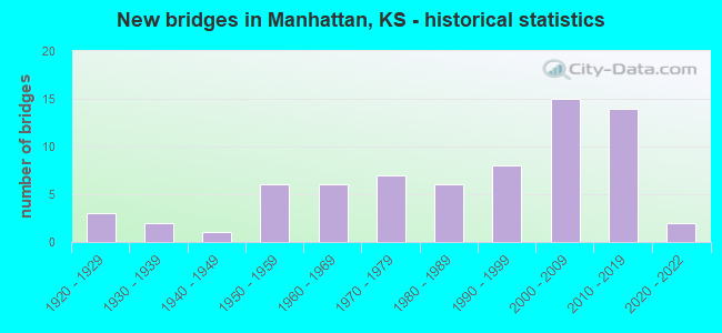
- New bridges - historical statistics
- 31920-1929
- 21930-1939
- 11940-1949
- 61950-1959
- 61960-1969
- 71970-1979
- 61980-1989
- 81990-1999
- 152000-2009
- 142010-2019
- 22020-2022
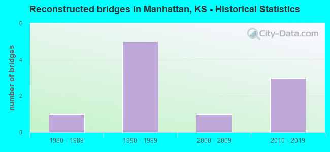
- Reconstructed bridges - Historical Statistics
- 11980-1989
- 51990-1999
- 12000-2009
- 32010-2019
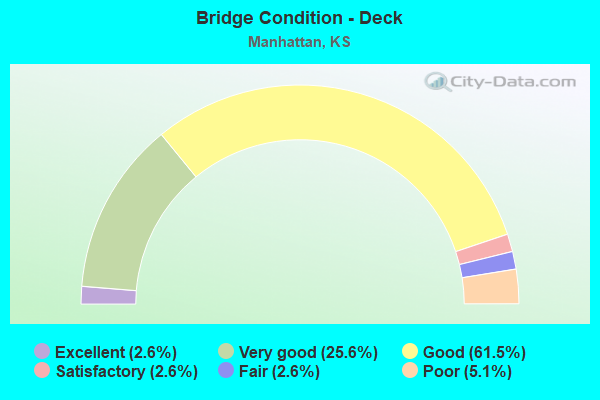
- Bridge Condition - Deck
- 2.6%Excellent
- 25.6%Very good
- 61.5%Good
- 2.6%Satisfactory
- 2.6%Fair
- 5.1%Poor
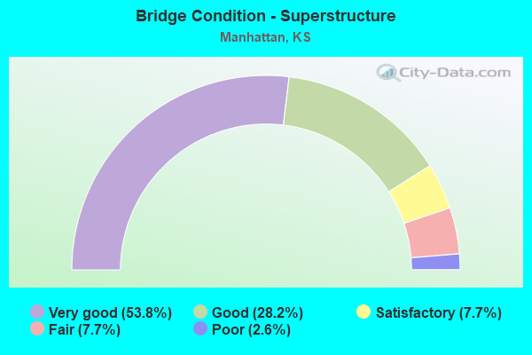
- Bridge Condition - Superstructure
- 53.8%Very good
- 28.2%Good
- 7.7%Satisfactory
- 7.7%Fair
- 2.6%Poor
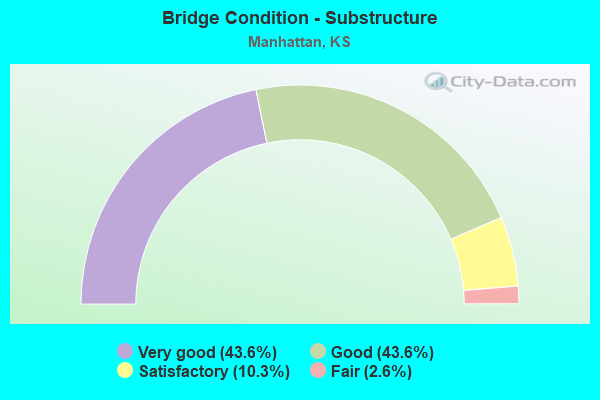
- Bridge Condition - Substructure
- 43.6%Very good
- 43.6%Good
- 10.3%Satisfactory
- 2.6%Fair
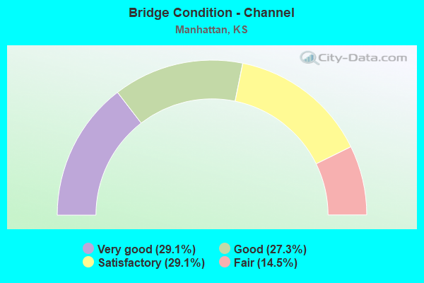
- Bridge Condition - Channel
- 29.1%Very good
- 27.3%Good
- 29.1%Satisfactory
- 14.5%Fair
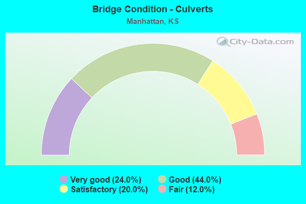
- Bridge Condition - Culverts
- 24.0%Very good
- 44.0%Good
- 20.0%Satisfactory
- 12.0%Fair
Find on map >> Show street view
Structure Number: 75008, Location: 2.0N OF MANHATTAN (Lat: 39.237608, Lng: -96.571297), Route carried "on" structure: County highway 536, Year Built: 1974, Status: Open, Structure Length: 11.73m (38.48ft), Average Daily Traffic: 1,210 (year 2013), Average Future Daily Traffic: 1,452 (year 2041), Design Load: HS 15, Features Intersected: BIG BLUE RIVER, Facility Carried by Structure: DYER RD.
Minimum Vertical Clearance: 30.47m (99.97ft), Kilometerpoint: 0.000, Lanes on structure: 2, Owner: County Highway Agency, Approaching Roadway Width: 12.2m (40.0ft), Material/Design: Steel continuous, Design/Construction: Stringer/Multi-beam, Number Of Spans In Main Unit: 3, Number Of Approach Spans: 1, Length of Maximum Span: 39.6m (129.9ft), Curb-To-Curb Width: 8.5m (27.9ft), Out-to-Out Width: 9.1m (29.9ft)
Condition: Deck: Good, Superstructure: Good, Substructure: Good, Channel: Satisfactory, Operating Rating: 45.0 metric tons, Method Used To Determine Operating Rating: Allowable Stress (AS), Inventory Rating: 26.1 metric tons, Method Used To Determine Inventory Rating: Allowable Stress (AS), Structural Evaluation: Equal to present minimum criteria, Deck Geometry: Somewhat better than minimum adequacy, Waterway Adequacy: Equal to present desirable criteria, Approach Roadway Alignment: Better than present minimum criteria, Designated Inspection Frequency: Every 24 months, Inspection Date: July 2021, Deck Structure Type: Concrete Cast-file-Place, Wearing Surface/Protective System: Wearing Surface: Bituminous
Find on map >> Show street view
Structure Number: 75065, Location: 1.0N 5.0W OF ST. GEORGE (Lat: 39.203500, Lng: -96.510647), Route carried "on" structure: County highway 1465, Year Built: 1984, Status: Open, Structure Length: 3.57m (11.71ft), Average Daily Traffic: 6,314 (year 2013), Average Future Daily Traffic: 7,577 (year 2041), Design Load: HS 20, Features Intersected: TRIB. TO BIG BLUE RIVER, Facility Carried by Structure: GREEN VALLEY ROAD
Minimum Vertical Clearance: 30.47m (99.97ft), Kilometerpoint: 0.000, Lanes on structure: 2, Owner: County Highway Agency, Approaching Roadway Width: 7.9m (25.9ft), Material/Design: Concrete continuous, Design/Construction: Slab, Number Of Spans In Main Unit: 3, Length of Maximum Span: 14.3m (46.9ft), Curb-To-Curb Width: 8.5m (27.9ft), Out-to-Out Width: 9.1m (29.9ft)
Condition: Deck: Fair, Superstructure: Fair, Substructure: Satisfactory, Channel: Satisfactory, Operating Rating: 69.9 metric tons, Method Used To Determine Operating Rating: Load Factor (LF), Inventory Rating: 41.8 metric tons, Method Used To Determine Inventory Rating: Load Factor (LF), Structural Evaluation: Somewhat better than minimum adequacy, Deck Geometry: High priority of replacement, Waterway Adequacy: Equal to present desirable criteria, Approach Roadway Alignment: Equal to present desirable criteria, Designated Inspection Frequency: Every 24 months, Inspection Date: July 2021, Deck Structure Type: Concrete Cast-file-Place
Find on map >> Show street view
Structure Number: 75066, Location: 2.0N OF MANHATTAN (Lat: 39.241192, Lng: -96.577250), Route carried "on" structure: County highway 1872, Year Built: 1970, Status: Posted for load, Structure Length: 4.39m (14.40ft), Average Daily Traffic: 177 (year 2013), Truck Traffic: 1%, Average Future Daily Traffic: 212 (year 2041), Design Load: H 15, Features Intersected: CEDAR CREEK, Facility Carried by Structure: BLUE RIVER ROAD
Minimum Vertical Clearance: 30.47m (99.97ft), Kilometerpoint: 0.000, Lanes on structure: 2, Owner: County Highway Agency, Approaching Roadway Width: 9.1m (29.9ft), Skew: 3 degrees, Material/Design: Concrete continuous, Design/Construction: Stringer/Multi-beam, Number Of Spans In Main Unit: 3, Length of Maximum Span: 17.4m (57.1ft), Curb-To-Curb Width: 8.5m (27.9ft), Out-to-Out Width: 9.1m (29.9ft)
Condition: Deck: Good, Superstructure: Very good, Substructure: Good, Channel: Satisfactory, Operating Rating: 37.8 metric tons, Method Used To Determine Operating Rating: Load Factor (LF), Inventory Rating: 22.5 metric tons, Method Used To Determine Inventory Rating: Load Factor (LF), Structural Evaluation: Equal to present minimum criteria, Deck Geometry: Equal to present minimum criteria, Waterway Adequacy: Equal to present desirable criteria, Approach Roadway Alignment: Equal to present desirable criteria, Designated Inspection Frequency: Every 24 months, Inspection Date: July 2021, Deck Structure Type: Concrete Cast-file-Place
Find on map >> Show street view
Structure Number: 81027, Location: 3.5E 0.5S OF OGDEN (Lat: 39.102647, Lng: -96.644167), Route carried "on" structure: County highway 1092, Year Built: 1980, Status: Open, Structure Length: 4.65m (15.26ft), Average Daily Traffic: 351 (year 2004), Truck Traffic: 20%, Average Future Daily Traffic: 360 (year 2040), Design Load: H 20, Features Intersected: MCDOWELL CREEK
Minimum Vertical Clearance: 30.47m (99.97ft), Kilometerpoint: 3.862, Lanes on structure: 2, Owner: County Highway Agency, Approaching Roadway Width: 12.1m (39.7ft), Material/Design: Concrete continuous, Design/Construction: Slab, Number Of Spans In Main Unit: 3, Length of Maximum Span: 18.3m (60.0ft), Curb-To-Curb Width: 11.0m (36.1ft), Out-to-Out Width: 11.5m (37.7ft)
Condition: Deck: Poor, Superstructure: Satisfactory, Substructure: Good, Channel: Satisfactory, Operating Rating: 43.5 metric tons, Method Used To Determine Operating Rating: Load Factor (LF), Inventory Rating: 26.0 metric tons, Method Used To Determine Inventory Rating: Load Factor (LF), Structural Evaluation: Equal to present minimum criteria, Deck Geometry: Equal to present desirable criteria, Waterway Adequacy: Equal to present desirable criteria, Approach Roadway Alignment: Equal to present desirable criteria, Length Of Structure Improvement: 4.57m (14.99ft), Designated Inspection Frequency: Every 24 months, Inspection Date: December 2020, Bridge Improvement Cost: $50,000, Roadway Improvement Cost: $12,000, Total Project Cost: $75,000, Deck Structure Type: Concrete Cast-file-Place
Find on map >> Show street view
Structure Number: 81029, Location: 4.0S OF MANHATTAN (Lat: 39.118111, Lng: -96.579992), Route carried "on" structure: County highway 1092, Year Built: 1976, Status: Posted for load, Structure Length: 0.64m (2.10ft), Average Daily Traffic: 784 (year 2004), Truck Traffic: 20%, Average Future Daily Traffic: 790 (year 2040), Design Load: H 20, Features Intersected: TRIB. TO MCDOWELL CREEK
Minimum Vertical Clearance: 30.47m (99.97ft), Kilometerpoint: 10.155, Lanes on structure: 2, Owner: County Highway Agency, Approaching Roadway Width: 11.6m (38.1ft), Skew: 4 degrees, Material/Design: Concrete, Design/Construction: Culvert, Number Of Spans In Main Unit: 2, Length of Maximum Span: 3.0m (9.8ft), Curb-To-Curb Width: 25.3m (83.0ft), Out-to-Out Width: 25.9m (85.0ft)
Condition: Channel: Very good, Culverts: Good, Operating Rating: 49.5 metric tons, Method Used To Determine Operating Rating: Load Factor (LF), Inventory Rating: 29.7 metric tons, Method Used To Determine Inventory Rating: Load Factor (LF), Structural Evaluation: Better than present minimum criteria, Deck Geometry: Superior to present desirable criteria, Waterway Adequacy: Equal to present desirable criteria, Approach Roadway Alignment: Equal to present desirable criteria, Designated Inspection Frequency: Every 24 months, Inspection Date: December 2020
Find on map >> Show street view
Structure Number: 81044, Location: 0.2E OF KEATS (Lat: 39.220375, Lng: -96.701225), Route carried "on" structure: County highway 1925, Year Built: 1927, Status: Open, Structure Length: 0.73m (2.40ft), Average Daily Traffic: 697 (year 2004), Truck Traffic: 12%, Average Future Daily Traffic: 700 (year 2040), Features Intersected: KITTEN CREEK
Minimum Vertical Clearance: 30.47m (99.97ft), Kilometerpoint: 13.200, Lanes on structure: 2, Owner: County Highway Agency, Approaching Roadway Width: 7.3m (24.0ft), Material/Design: Concrete, Design/Construction: Culvert, Number Of Spans In Main Unit: 2, Length of Maximum Span: 3.0m (9.8ft), Curb or Sidewalk Widths: Left: 0.4m (1.3ft), Right: 0.4m (1.3ft), Curb-To-Curb Width: 8.8m (28.9ft), Out-to-Out Width: 9.6m (31.5ft)
Condition: Channel: Fair, Culverts: Good, Operating Rating: 27.0 metric tons, Method Used To Determine Operating Rating: No rating analysis performed, Inventory Rating: 16.2 metric tons, Method Used To Determine Inventory Rating: No rating analysis performed, Structural Evaluation: Meets minimum limits, Deck Geometry: Somewhat better than minimum adequacy, Waterway Adequacy: Equal to present minimum criteria, Approach Roadway Alignment: Equal to present desirable criteria, Length Of Structure Improvement: 0.73m (2.40ft), Designated Inspection Frequency: Every 24 months, Inspection Date: December 2020, Bridge Improvement Cost: $75,000, Roadway Improvement Cost: $30,000, Total Project Cost: $125,000
Find on map >> Show street view
Structure Number: 81045, Location: 1.5E 0.8S OF KEATS (Lat: 39.210719, Lng: -96.679597), Route carried "on" structure: County highway 1925, Year Built: 2008, Status: Open, Structure Length: 2.83m (9.28ft), Average Daily Traffic: 1,251 (year 2004), Truck Traffic: 12%, Average Future Daily Traffic: 700 (year 2040), Design Load: HS 20, Features Intersected: NATALIES CREEK
Minimum Vertical Clearance: 30.47m (99.97ft), Kilometerpoint: 6.550, Lanes on structure: 2, Owner: County Highway Agency, Approaching Roadway Width: 7.3m (24.0ft), Material/Design: Concrete continuous, Design/Construction: Slab, Number Of Spans In Main Unit: 3, Length of Maximum Span: 10.1m (33.1ft), Curb-To-Curb Width: 11.0m (36.1ft), Out-to-Out Width: 11.6m (38.1ft)
Condition: Deck: Very good, Superstructure: Very good, Substructure: Very good, Channel: Very good, Operating Rating: 70.3 metric tons, Method Used To Determine Operating Rating: Load Factor (LF), Inventory Rating: 42.1 metric tons, Method Used To Determine Inventory Rating: Load Factor (LF), Structural Evaluation: Equal to present desirable criteria, Deck Geometry: Equal to present minimum criteria, Waterway Adequacy: Equal to present desirable criteria, Approach Roadway Alignment: Equal to present desirable criteria, Designated Inspection Frequency: Every 24 months, Inspection Date: December 2020, Deck Structure Type: Concrete Cast-file-Place
Find on map >> Show street view
Structure Number: 81046, Location: 2.0E 1.3S OF KEATS (Lat: 39.205447, Lng: -96.669700), Route carried "on" structure: County highway 1925, Year Built: 1928, Status: Posted for load, Structure Length: 0.98m (3.22ft), Average Daily Traffic: 697 (year 2004), Truck Traffic: 12%, Average Future Daily Traffic: 700 (year 2040), Features Intersected: STREAM
Minimum Vertical Clearance: 30.47m (99.97ft), Kilometerpoint: 15.937, Lanes on structure: 2, Owner: County Highway Agency, Approaching Roadway Width: 7.3m (24.0ft), Material/Design: Concrete, Design/Construction: Culvert, Number Of Spans In Main Unit: 3, Length of Maximum Span: 3.0m (9.8ft), Curb or Sidewalk Widths: Left: 0.4m (1.3ft), Right: 0.4m (1.3ft), Curb-To-Curb Width: 9.1m (29.9ft), Out-to-Out Width: 9.9m (32.5ft)
Condition: Channel: Fair, Culverts: Satisfactory, Operating Rating: 28.8 metric tons, Method Used To Determine Operating Rating: No rating analysis performed, Inventory Rating: 24.3 metric tons, Method Used To Determine Inventory Rating: No rating analysis performed, Structural Evaluation: Equal to present minimum criteria, Deck Geometry: Equal to present minimum criteria, Waterway Adequacy: Equal to present minimum criteria, Approach Roadway Alignment: Equal to present desirable criteria, Length Of Structure Improvement: 0.98m (3.22ft), Designated Inspection Frequency: Every 24 months, Inspection Date: December 2020, Bridge Improvement Cost: $57,000, Roadway Improvement Cost: $10,000, Total Project Cost: $86,000
Find on map >> Show street view
Structure Number: 81B41, Location: 1.0N OF MANHATTAN (Lat: 39.218569, Lng: -96.588339), Route carried "on" structure: County highway 3832, Year Built: 2017, Status: Open, Structure Length: 1.20m (3.94ft), Average Daily Traffic: 1,837 (year 2017), Truck Traffic: 10%, Average Future Daily Traffic: 1,845 (year 2040), Design Load: HL 93, Features Intersected: STREAM, Facility Carried by Structure: RS 1797 T.9-24.0F
Minimum Vertical Clearance: 30.47m (99.97ft), Kilometerpoint: 0.000, Lanes on structure: 2, Owner: County Highway Agency, Approaching Roadway Width: 7.9m (25.9ft), Material/Design: Concrete, Design/Construction: Culvert, Number Of Spans In Main Unit: 3, Length of Maximum Span: 3.7m (12.1ft), Curb-To-Curb Width: 24.7m (81.0ft), Out-to-Out Width: 25.3m (83.0ft)
Condition: Channel: Very good, Culverts: Very good, Operating Rating: 88.0 metric tons, Method Used To Determine Operating Rating: Load and Resistance Factor (LRFR), Inventory Rating: 52.6 metric tons, Method Used To Determine Inventory Rating: Load and Resistance Factor (LRFR), Structural Evaluation: Equal to present desirable criteria, Deck Geometry: Superior to present desirable criteria, Waterway Adequacy: Equal to present desirable criteria, Approach Roadway Alignment: Equal to present desirable criteria, Designated Inspection Frequency: Every 24 months, Inspection Date: December 2020, Deck Structure Type: Concrete Cast-file-Place, Wearing Surface/Protective System: Wearing Surface: Bituminous
Find on map >> Show street view
Structure Number: 81B43, Location: AT KEATS (Lat: 39.223769, Lng: -96.706400), Route carried "on" structure: County highway 1925, Year Built: 2020, Status: Open, Structure Length: 3.75m (12.30ft), Average Daily Traffic: 697 (year 2004), Truck Traffic: 12%, Average Future Daily Traffic: 767 (year 2040), Design Load: HL 93, Features Intersected: KITTEN CREEK
Minimum Vertical Clearance: 30.47m (99.97ft), Kilometerpoint: 0.000, Lanes on structure: 2, Owner: County Highway Agency, Approaching Roadway Width: 10.9m (35.8ft), Skew: 3 degrees, Material/Design: Concrete continuous, Design/Construction: Slab, Number Of Spans In Main Unit: 3, Length of Maximum Span: 14.6m (47.9ft), Curb-To-Curb Width: 11.0m (36.1ft), Out-to-Out Width: 11.6m (38.1ft)
Condition: Deck: Very good, Superstructure: Very good, Substructure: Very good, Channel: Very good, Operating Rating: 78.7 metric tons, Method Used To Determine Operating Rating: Load and Resistance Factor (LRFR), Inventory Rating: 50.5 metric tons, Method Used To Determine Inventory Rating: Load and Resistance Factor (LRFR), Structural Evaluation: Equal to present desirable criteria, Deck Geometry: Better than present minimum criteria, Waterway Adequacy: Equal to present desirable criteria, Approach Roadway Alignment: Equal to present desirable criteria, Designated Inspection Frequency: Every 24 months, Inspection Date: December 2020, Deck Structure Type: Concrete Cast-file-Place, Wearing Surface/Protective System: Wearing Surface: Monolithic Concrete, Deck Protection: Epoxy Coated Reinforcing
Find on map >> Show street view
Structure Number: 750901804023, Location: 3.0S 6.5W OF FLUSH (Lat: 39.258794, Lng: -96.563756), Route carried "on" structure: County highway , Year Built: 1970, Status: Posted for load, Structure Length: 1.13m (3.71ft), Average Daily Traffic: 10 (year 2013), Average Future Daily Traffic: 15 (year 2041), Features Intersected: CEDAR CREEK, Facility Carried by Structure: CEDAR CREEK ROAD
Minimum Vertical Clearance: 30.47m (99.97ft), Kilometerpoint: 0.000, Lanes on structure: 1, Owner: County Highway Agency, Approaching Roadway Width: 5.5m (18.0ft), Material/Design: Steel, Design/Construction: Girder and Floorbeam System, Number Of Spans In Main Unit: 1, Length of Maximum Span: 10.7m (35.1ft), Curb-To-Curb Width: 4.7m (15.4ft), Out-to-Out Width: 4.7m (15.4ft)
Condition: Deck: Satisfactory, Superstructure: Satisfactory, Substructure: Fair, Channel: Satisfactory, Operating Rating: 22.8 metric tons, Method Used To Determine Operating Rating: Load Factor (LF), Inventory Rating: 13.6 metric tons, Method Used To Determine Inventory Rating: Load Factor (LF), Structural Evaluation: Meets minimum limits, Deck Geometry: Better than present minimum criteria, Waterway Adequacy: Equal to present minimum criteria, Approach Roadway Alignment: Better than present minimum criteria, Bridge Posting: Required (Relationship of Operating Rating to Maximum Legal Load: > 39.9% below), Designated Inspection Frequency: Every 24 months, Inspection Date: July 2021, Deck Structure Type: Wood or Timber, Wearing Surface/Protective System: Wearing Surface: Wood or Timber
Find on map >> Show street view
Structure Number: 750903304004, Location: 2.0S 6.0W OF FLUSH (Lat: 39.269303, Lng: -96.551319), Route carried "on" structure: County highway , Year Built: 1993, Status: Open, Structure Length: 1.77m (5.81ft), Average Daily Traffic: 10 (year 2013), Average Future Daily Traffic: 15 (year 2041), Features Intersected: TRIB. TO CEDAR CREEK, Facility Carried by Structure: CEDAR CREEK ROAD
Minimum Vertical Clearance: 30.47m (99.97ft), Kilometerpoint: 0.000, Lanes on structure: 2, Owner: County Highway Agency, Approaching Roadway Width: 7.3m (24.0ft), Skew: 3 degrees, Material/Design: Steel, Design/Construction: Stringer/Multi-beam, Number Of Spans In Main Unit: 1, Length of Maximum Span: 17.1m (56.1ft), Curb-To-Curb Width: 7.3m (24.0ft), Out-to-Out Width: 7.5m (24.6ft)
Condition: Deck: Good, Superstructure: Good, Substructure: Good, Channel: Satisfactory, Operating Rating: 20.2 metric tons, Method Used To Determine Operating Rating: Load Factor (LF), Inventory Rating: 12.2 metric tons, Method Used To Determine Inventory Rating: Load Factor (LF), Structural Evaluation: Meets minimum limits, Deck Geometry: Equal to present minimum criteria, Waterway Adequacy: Somewhat better than minimum adequacy, Approach Roadway Alignment: Equal to present minimum criteria, Designated Inspection Frequency: Every 24 months, Inspection Date: July 2021, Deck Structure Type: Concrete Cast-file-Place, Wearing Surface/Protective System: Wearing Surface: Gravel
Find on map >> Show street view
Structure Number: 750911004109, Location: 3.4W OF ST. GEORGE (Lat: 39.188517, Lng: -96.482519), Route carried "on" structure: County highway , Year Built: 1989, Status: Open, Structure Length: 0.69m (2.26ft), Average Daily Traffic: 25 (year 2013), Average Future Daily Traffic: 30 (year 2041), Features Intersected: TRIB. TO SAND CREEK, Facility Carried by Structure: SWAMP ANGEL ROAD
Minimum Vertical Clearance: 30.47m (99.97ft), Kilometerpoint: 0.000, Lanes on structure: 2, Owner: County Highway Agency, Approaching Roadway Width: 9.8m (32.2ft), Material/Design: Steel, Design/Construction: Stringer/Multi-beam, Number Of Spans In Main Unit: 1, Length of Maximum Span: 6.4m (21.0ft), Curb-To-Curb Width: 6.6m (21.7ft), Out-to-Out Width: 6.8m (22.3ft)
Condition: Deck: Good, Superstructure: Good, Substructure: Good, Channel: Satisfactory, Operating Rating: 51.3 metric tons, Method Used To Determine Operating Rating: Allowable Stress (AS), Inventory Rating: 36.0 metric tons, Method Used To Determine Inventory Rating: Allowable Stress (AS), Structural Evaluation: Better than present minimum criteria, Deck Geometry: Somewhat better than minimum adequacy, Waterway Adequacy: Equal to present minimum criteria, Approach Roadway Alignment: Equal to present desirable criteria, Designated Inspection Frequency: Every 24 months, Inspection Date: July 2021, Deck Structure Type: Open Grating, Wearing Surface/Protective System: Wearing Surface: Other
Find on map >> Show street view
Structure Number: 810891004167, Location: 1.5E 2.3N OF OGDEN (Lat: 39.150331, Lng: -96.681900), Route carried "on" structure: County highway , Year Built: 2008, Status: Open, Structure Length: 1.49m (4.89ft), Average Daily Traffic: 1,635 (year 2004), Truck Traffic: 15%, Average Future Daily Traffic: 1,645 (year 2040), Design Load: HS 20, Features Intersected: Eureka Valley Tributary, Facility Carried by Structure: LOCAL P.0-28.7T
Minimum Vertical Clearance: 30.47m (99.97ft), Kilometerpoint: 0.000, Lanes on structure: 2, Owner: County Highway Agency, Approaching Roadway Width: 11.2m (36.7ft), Material/Design: Concrete, Design/Construction: Slab, Number Of Spans In Main Unit: 1, Length of Maximum Span: 13.1m (43.0ft), Curb or Sidewalk Widths: Left: 0.0m, Right: 1.7m (5.6ft), Curb-To-Curb Width: 11.3m (37.1ft), Out-to-Out Width: 13.6m (44.6ft)
Condition: Deck: Very good, Superstructure: Very good, Substructure: Very good, Channel: Very good, Operating Rating: 49.0 metric tons, Method Used To Determine Operating Rating: Load Factor (LF), Inventory Rating: 29.9 metric tons, Method Used To Determine Inventory Rating: Load Factor (LF), Structural Evaluation: Better than present minimum criteria, Deck Geometry: Equal to present minimum criteria, Waterway Adequacy: Equal to present desirable criteria, Approach Roadway Alignment: Equal to present desirable criteria, Length Of Structure Improvement: 1.52m (4.99ft), Designated Inspection Frequency: Every 24 months, Inspection Date: December 2020, Bridge Improvement Cost: $85,000, Roadway Improvement Cost: $25,000, Total Project Cost: $145,000, Deck Structure Type: Concrete Cast-file-Place, Wearing Surface/Protective System: Deck Protection: Epoxy Coated Reinforcing
Find on map >> Show street view
Structure Number: 810891504207, Location: 1.0E OF OGDEN (Lat: 39.122144, Lng: -96.680728), Route carried "on" structure: County highway , Year Built: 1993, Status: Open, Structure Length: 0.85m (2.79ft), Average Daily Traffic: 30 (year 2004), Average Future Daily Traffic: 35 (year 2040), Design Load: HS 20, Features Intersected: SEVEN MILE CREEK, Facility Carried by Structure: LOCAL P.5-30.7T
Minimum Vertical Clearance: 30.47m (99.97ft), Kilometerpoint: 0.000, Lanes on structure: 2, Owner: County Highway Agency, Approaching Roadway Width: 7.3m (24.0ft), Skew: 3 degrees, Material/Design: Concrete, Design/Construction: Culvert, Number Of Spans In Main Unit: 1, Length of Maximum Span: 8.5m (27.9ft), Curb-To-Curb Width: 7.3m (24.0ft), Out-to-Out Width: 9.1m (29.9ft)
Condition: Channel: Good, Culverts: Satisfactory, Operating Rating: 64.3 metric tons, Method Used To Determine Operating Rating: Load Factor (LF), Inventory Rating: 38.5 metric tons, Method Used To Determine Inventory Rating: Load Factor (LF), Structural Evaluation: Equal to present minimum criteria, Deck Geometry: Equal to present minimum criteria, Waterway Adequacy: Better than present minimum criteria, Approach Roadway Alignment: Equal to present desirable criteria, Designated Inspection Frequency: Every 24 months, Inspection Date: December 2020
Find on map >> Show street view
Structure Number: 810891604107, Location: 2.5 mi west of Manhattan (Lat: 39.191944, Lng: -96.670000), Route carried "on" structure: County highway , Year Built: 2007, Status: Open, Structure Length: 3.12m (10.24ft), Average Daily Traffic: 100 (year 2004), Average Future Daily Traffic: 110 (year 2040), Design Load: HS 20, Features Intersected: Trib. To Wildcat Creek, Facility Carried by Structure: MINOR P.6-25.7
Minimum Vertical Clearance: 30.47m (99.97ft), Kilometerpoint: 0.000, Lanes on structure: 2, Owner: County Highway Agency, Approaching Roadway Width: 8.5m (27.9ft), Material/Design: Concrete continuous, Design/Construction: Slab, Number Of Spans In Main Unit: 3, Length of Maximum Span: 12.2m (40.0ft), Curb-To-Curb Width: 8.5m (27.9ft), Out-to-Out Width: 9.1m (29.9ft)
Condition: Deck: Very good, Superstructure: Very good, Substructure: Very good, Channel: Very good, Operating Rating: 79.2 metric tons, Method Used To Determine Operating Rating: Load Factor (LF), Inventory Rating: 47.4 metric tons, Method Used To Determine Inventory Rating: Load Factor (LF), Structural Evaluation: Equal to present desirable criteria, Deck Geometry: Better than present minimum criteria, Waterway Adequacy: Equal to present desirable criteria, Approach Roadway Alignment: Equal to present desirable criteria, Designated Inspection Frequency: Every 24 months, Inspection Date: December 2020, Deck Structure Type: Concrete Cast-file-Place, Wearing Surface/Protective System: Wearing Surface: Monolithic Concrete
Find on map >> Show street view
Structure Number: 810893004167, Location: 2.8E 2.3N OF OGDEN (Lat: 39.150519, Lng: -96.663361), Route carried "on" structure: County highway , Year Built: 1920, Status: Posted for load, Structure Length: 0.85m (2.79ft), Average Daily Traffic: 2 (year 2004), Average Future Daily Traffic: 2 (year 2041), Features Intersected: TRIB. TO KANSAS RIVER, Facility Carried by Structure: LOCAL Q.0-28.7T
Minimum Vertical Clearance: 30.47m (99.97ft), Kilometerpoint: 1.751, Lanes on structure: 2, Owner: County Highway Agency, Approaching Roadway Width: 5.4m (17.7ft), Material/Design: Concrete, Design/Construction: Stringer/Multi-beam, Number Of Spans In Main Unit: 1, Length of Maximum Span: 7.9m (25.9ft), Curb or Sidewalk Widths: Left: 0.3m (1.0ft), Right: 0.3m (1.0ft), Curb-To-Curb Width: 4.9m (16.1ft), Out-to-Out Width: 5.5m (18.0ft)
Condition: Deck: Good, Superstructure: Poor, Substructure: Good, Channel: Satisfactory, Operating Rating: 14.4 metric tons, Method Used To Determine Operating Rating: No rating analysis performed, Inventory Rating: 9.9 metric tons, Method Used To Determine Inventory Rating: No rating analysis performed, Structural Evaluation: High priority of corrective action, Deck Geometry: High priority of corrective action, Waterway Adequacy: Equal to present minimum criteria, Approach Roadway Alignment: Somewhat better than minimum adequacy, Bridge Posting: Required (Relationship of Operating Rating to Maximum Legal Load: 20.0 - 29.9% below), Length Of Structure Improvement: 0.98m (3.22ft), Designated Inspection Frequency: Every 12 months, Inspection Date: December 2021, Bridge Improvement Cost: $48,000, Roadway Improvement Cost: $15,000, Total Project Cost: $75,000, Deck Structure Type: Concrete Cast-file-Place
Find on map >> Show street view
Structure Number: 810893004208, Location: 0.2N-2.3E OF OGDEN (Lat: 39.119250, Lng: -96.671247), Route carried "on" structure: County highway , Year Built: 1989, Status: Open, Structure Length: 0.85m (2.79ft), Average Daily Traffic: 30 (year 2004), Average Future Daily Traffic: 35 (year 2040), Design Load: H 20, Features Intersected: SEVEN MILE CREEK, Facility Carried by Structure: LOCAL Q.0-30.8T
Minimum Vertical Clearance: 30.47m (99.97ft), Kilometerpoint: 0.000, Lanes on structure: 2, Owner: County Highway Agency, Approaching Roadway Width: 6.0m (19.7ft), Skew: 3 degrees, Material/Design: Concrete, Design/Construction: Culvert, Number Of Spans In Main Unit: 1, Length of Maximum Span: 8.5m (27.9ft), Curb-To-Curb Width: 7.3m (24.0ft), Out-to-Out Width: 7.9m (25.9ft)
Condition: Channel: Good, Culverts: Good, Operating Rating: 99.0 metric tons, Method Used To Determine Operating Rating: Load Factor (LF), Inventory Rating: 59.2 metric tons, Method Used To Determine Inventory Rating: Load Factor (LF), Structural Evaluation: Better than present minimum criteria, Deck Geometry: Equal to present minimum criteria, Waterway Adequacy: Equal to present desirable criteria, Approach Roadway Alignment: Equal to present desirable criteria, Length Of Structure Improvement: 0.85m (2.79ft), Designated Inspection Frequency: Every 24 months, Inspection Date: December 2020, Bridge Improvement Cost: $49,000, Roadway Improvement Cost: $10,000, Total Project Cost: $74,000
Find on map >> Show street view
Structure Number: 81089370412, Location: 1.5W OF MANHATTAN (Lat: 39.189292, Lng: -96.649867), Route carried "on" structure: County highway 8104, Year Built: 1989, Status: Posted for load, Structure Length: 3.96m (12.99ft), Average Daily Traffic: 175 (year 2004), Truck Traffic: 12%, Average Future Daily Traffic: 180 (year 2040), Design Load: H 20, Features Intersected: WILDCAT CREEK, Facility Carried by Structure: MINOR Q.7-26.0T
Minimum Vertical Clearance: 30.47m (99.97ft), Kilometerpoint: 0.000, Lanes on structure: 2, Owner: County Highway Agency, Approaching Roadway Width: 9.1m (29.9ft), Material/Design: Concrete continuous, Design/Construction: Slab, Number Of Spans In Main Unit: 3, Length of Maximum Span: 15.8m (51.8ft), Curb-To-Curb Width: 7.9m (25.9ft), Out-to-Out Width: 8.5m (27.9ft)
Condition: Deck: Good, Superstructure: Very good, Substructure: Very good, Channel: Fair, Operating Rating: 42.9 metric tons, Method Used To Determine Operating Rating: Load Factor (LF), Inventory Rating: 25.7 metric tons, Method Used To Determine Inventory Rating: Load Factor (LF), Structural Evaluation: Equal to present minimum criteria, Deck Geometry: Somewhat better than minimum adequacy, Waterway Adequacy: Better than present minimum criteria, Approach Roadway Alignment: Equal to present minimum criteria, Length Of Structure Improvement: 3.96m (12.99ft), Designated Inspection Frequency: Every 24 months, Inspection Date: December 2020, Bridge Improvement Cost: $228,000, Roadway Improvement Cost: $35,000, Total Project Cost: $342,000, Deck Structure Type: Concrete Cast-file-Place
Find on map >> Show street view
Structure Number: 810899004208, Location: 5.0E OF OGDEN (Lat: 39.119911, Lng: -96.613886), Route carried "on" structure: County highway , Year Built: 1971, Status: Posted for load, Structure Length: 6.13m (20.11ft), Average Daily Traffic: 70 (year 2004), Average Future Daily Traffic: 75 (year 0000), Design Load: H 15, Features Intersected: MC DOWELL'S CREEK, Facility Carried by Structure: LOCAL T.0-30.8T
Minimum Vertical Clearance: 30.47m (99.97ft), Kilometerpoint: 0.000, Lanes on structure: 2, Owner: County Highway Agency, Approaching Roadway Width: 8.5m (27.9ft), Skew: 3 degrees, Material/Design: Steel continuous, Design/Construction: Stringer/Multi-beam, Number Of Spans In Main Unit: 3, Length of Maximum Span: 23.2m (76.1ft), Curb or Sidewalk Widths: Left: 0.3m (1.0ft), Right: 0.3m (1.0ft), Curb-To-Curb Width: 8.5m (27.9ft), Out-to-Out Width: 9.1m (29.9ft)
Condition: Deck: Poor, Superstructure: Fair, Substructure: Satisfactory, Channel: Fair, Operating Rating: 27.0 metric tons, Method Used To Determine Operating Rating: Allowable Stress (AS), Inventory Rating: 14.4 metric tons, Method Used To Determine Inventory Rating: Allowable Stress (AS), Structural Evaluation: Meets minimum limits, Deck Geometry: Better than present minimum criteria, Waterway Adequacy: Equal to present minimum criteria, Approach Roadway Alignment: Equal to present desirable criteria, Bridge Posting: Required (Relationship of Operating Rating to Maximum Legal Load: 0.1 - 9.9% below), Length Of Structure Improvement: 6.13m (20.11ft), Designated Inspection Frequency: Every 12 months, Inspection Date: December 2021, Bridge Improvement Cost: $352,000, Roadway Improvement Cost: $35,000, Total Project Cost: $527,000, Deck Structure Type: Concrete Cast-file-Place
Find on map >> Show street view
Structure Number: 810899504085, Location: College Ave (Lat: 39.211197, Lng: -96.598142), Route carried "on" structure: County highway , Year Built: 2003, Status: Open, Structure Length: 2.19m (7.19ft), Average Daily Traffic: 1,000 (year 2004), Truck Traffic: 12%, Average Future Daily Traffic: 1,000 (year 2040), Design Load: HS 20, Features Intersected: Stream, Facility Carried by Structure: COLLEGE AVE T.5-24
Minimum Vertical Clearance: 30.47m (99.97ft), Kilometerpoint: 0.000, Lanes on structure: 2, Owner: County Highway Agency, Approaching Roadway Width: 13.6m (44.6ft), Material/Design: Concrete continuous, Design/Construction: Slab, Number Of Spans In Main Unit: 3, Length of Maximum Span: 8.4m (27.6ft), Curb-To-Curb Width: 13.7m (44.9ft), Out-to-Out Width: 14.3m (46.9ft)
Condition: Deck: Good, Superstructure: Very good, Substructure: Very good, Channel: Very good, Operating Rating: 74.8 metric tons, Method Used To Determine Operating Rating: Load Factor (LF), Inventory Rating: 44.7 metric tons, Method Used To Determine Inventory Rating: Load Factor (LF), Structural Evaluation: Equal to present desirable criteria, Deck Geometry: Superior to present desirable criteria, Waterway Adequacy: Better than present minimum criteria, Approach Roadway Alignment: Equal to present desirable criteria, Designated Inspection Frequency: Every 24 months, Inspection Date: December 2020, Deck Structure Type: Concrete Cast-file-Place, Wearing Surface/Protective System: Deck Protection: Epoxy Coated Reinforcing
Find on map >> Show street view
Structure Number: 810901504141, Location: SOUTH EDGE OF MANHATTAN (Lat: 39.172047, Lng: -96.576767), Route carried "on" structure: County highway , Year Built: 2006, Status: Open, Structure Length: 7.98m (26.18ft), Average Daily Traffic: 2,100 (year 2004), Truck Traffic: 10%, Average Future Daily Traffic: 2,150 (year 2040), Design Load: HS 20, Features Intersected: WILDCAT CREEK, Facility Carried by Structure: LOCAL U.6-27.2C
Minimum Vertical Clearance: 30.47m (99.97ft), Kilometerpoint: 0.000, Lanes on structure: 2, Owner: County Highway Agency, Approaching Roadway Width: 8.5m (27.9ft), Material/Design: Prestressed concrete continuous, Design/Construction: Stringer/Multi-beam, Number Of Spans In Main Unit: 3, Length of Maximum Span: 32.3m (106.0ft), Curb or Sidewalk Widths: Left: 0.0m, Right: 1.8m (5.9ft), Curb-To-Curb Width: 11.0m (36.1ft), Out-to-Out Width: 13.7m (44.9ft)
Condition: Deck: Good, Superstructure: Very good, Substructure: Very good, Channel: Fair, Operating Rating: 64.1 metric tons, Method Used To Determine Operating Rating: Load Factor (LF), Inventory Rating: 38.4 metric tons, Method Used To Determine Inventory Rating: Load Factor (LF), Structural Evaluation: Equal to present desirable criteria, Deck Geometry: Somewhat better than minimum adequacy, Waterway Adequacy: Better than present minimum criteria, Approach Roadway Alignment: Better than present minimum criteria, Designated Inspection Frequency: Every 24 months, Inspection Date: December 2020, Deck Structure Type: Concrete Cast-file-Place, Wearing Surface/Protective System: Deck Protection: Epoxy Coated Reinforcing
Find on map >> Show street view
Structure Number: 810903004164, Location: 3.2E 2.0N OF ASHLAND (Lat: 39.154561, Lng: -96.557411), Route carried "on" structure: Other road 3837, Year Built: 1963, Status: Open, Structure Length: 0.62m (2.03ft), Average Daily Traffic: 784 (year 2004), Truck Traffic: 20%, Average Future Daily Traffic: 800 (year 2040), Design Load: HS 20, Features Intersected: STREAM, Facility Carried by Structure: LOCAL V.0-28.4
Minimum Vertical Clearance: 30.47m (99.97ft), Kilometerpoint: 0.000, Lanes on structure: 2, Owner: County Highway Agency, Approaching Roadway Width: 7.3m (24.0ft), Skew: 4 degrees, Material/Design: Concrete, Design/Construction: Culvert, Number Of Spans In Main Unit: 2, Length of Maximum Span: 2.1m (6.9ft), Curb-To-Curb Width: 8.5m (27.9ft), Out-to-Out Width: 9.1m (29.9ft)
Condition: Channel: Satisfactory, Culverts: Satisfactory, Operating Rating: 32.7 metric tons, Method Used To Determine Operating Rating: Load Testing, Inventory Rating: 18.1 metric tons, Method Used To Determine Inventory Rating: Load Testing, Structural Evaluation: Somewhat better than minimum adequacy, Deck Geometry: Somewhat better than minimum adequacy, Waterway Adequacy: Better than present minimum criteria, Approach Roadway Alignment: Equal to present desirable criteria, Designated Inspection Frequency: Every 24 months, Inspection Date: December 2020, Deck Structure Type: Concrete Cast-file-Place, Wearing Surface/Protective System: Wearing Surface: Bituminous
Find on map >> Show street view
Structure Number: 810903004165, Location: 3.2E 1.9N OF ASHLAND (Lat: 39.153817, Lng: -96.557053), Route carried "on" structure: County highway , Year Built: 1960, Year Reconstructed: 1998, Status: Posted for load, Structure Length: 0.91m (2.99ft), Average Daily Traffic: 5 (year 2004), Average Future Daily Traffic: 5 (year 2040), Features Intersected: STREAM, Facility Carried by Structure: LOCAL V.0-28.5
Minimum Vertical Clearance: 30.47m (99.97ft), Kilometerpoint: 0.000, Lanes on structure: 2, Owner: County Highway Agency, Approaching Roadway Width: 4.9m (16.1ft), Material/Design: Steel, Design/Construction: Stringer/Multi-beam, Number Of Spans In Main Unit: 1, Length of Maximum Span: 8.5m (27.9ft), Curb-To-Curb Width: 4.9m (16.1ft), Out-to-Out Width: 4.9m (16.1ft)
Condition: Deck: Good, Superstructure: Good, Substructure: Satisfactory, Channel: Fair, Operating Rating: 27.9 metric tons, Method Used To Determine Operating Rating: Load Factor (LF), Inventory Rating: 16.6 metric tons, Method Used To Determine Inventory Rating: Load Factor (LF), Structural Evaluation: Somewhat better than minimum adequacy, Deck Geometry: High priority of corrective action, Waterway Adequacy: Equal to present minimum criteria, Approach Roadway Alignment: Somewhat better than minimum adequacy, Bridge Posting: Required (Relationship of Operating Rating to Maximum Legal Load: > 39.9% below), Length Of Structure Improvement: 0.91m (2.99ft), Designated Inspection Frequency: Every 24 months, Inspection Date: December 2020, Bridge Improvement Cost: $20,000, Roadway Improvement Cost: $8,000, Total Project Cost: $30,000, Deck Structure Type: Corrugated Steel, Wearing Surface/Protective System: Wearing Surface: Bituminous
Find on map >> Show street view
Structure Number: 417750813814001, Location: ANDERSON AVE. (Lat: 39.189056, Lng: -96.627436), Route carried "on" structure: City street 3814, Year Built: 1935, Year Reconstructed: 1990, Status: Open, Structure Length: 0.76m (2.49ft), Average Daily Traffic: 2,642 (year 2000), Truck Traffic: 10%, Average Future Daily Traffic: 3,300 (year 2040), Features Intersected: TRIB. TO WILDCAT CREEK
Minimum Vertical Clearance: 30.47m (99.97ft), Kilometerpoint: 19.312, Lanes on structure: 2, Owner: City or Municipal Highway Agency, Approaching Roadway Width: 14.6m (47.9ft), Material/Design: Concrete, Design/Construction: Culvert, Number Of Spans In Main Unit: 2, Length of Maximum Span: 3.7m (12.1ft), Curb or Sidewalk Widths: Left: 1.5m (4.9ft), Right: 1.5m (4.9ft), Curb-To-Curb Width: 14.6m (47.9ft), Out-to-Out Width: 28.0m (91.9ft)
Condition: Channel: Satisfactory, Culverts: Good, Operating Rating: 54.4 metric tons, Method Used To Determine Operating Rating: Field evaluation and documented engineering judgment, Inventory Rating: 32.7 metric tons, Method Used To Determine Inventory Rating: Field evaluation and documented engineering judgment, Structural Evaluation: Better than present minimum criteria, Deck Geometry: Superior to present desirable criteria, Waterway Adequacy: Equal to present minimum criteria, Approach Roadway Alignment: Equal to present desirable criteria, Designated Inspection Frequency: Every 24 months, Inspection Date: June 2020
Find on map >> Show street view
Structure Number: 417750813824005, Location: W. OF VIRGINIA DR. (Lat: 39.196419, Lng: -96.611128), Route carried "on" structure: City street 3824, Year Built: 1958, Status: Open, Structure Length: 0.88m (2.89ft), Average Daily Traffic: 2,000 (year 2000), Truck Traffic: 5%, Average Future Daily Traffic: 2,100 (year 2040), Features Intersected: STREAM, Facility Carried by Structure: DICKENS AVE.,5080
Minimum Vertical Clearance: 30.47m (99.97ft), Kilometerpoint: 0.000, Lanes on structure: 2, Owner: City or Municipal Highway Agency, Approaching Roadway Width: 9.1m (29.9ft), Skew: 4 degrees, Material/Design: Concrete, Design/Construction: Culvert, Number Of Spans In Main Unit: 3, Length of Maximum Span: 2.7m (8.9ft), Curb or Sidewalk Widths: Left: 1.5m (4.9ft), Right: 0.0m, Curb-To-Curb Width: 9.1m (29.9ft), Out-to-Out Width: 16.8m (55.1ft)
Condition: Channel: Good, Culverts: Fair, Operating Rating: 32.7 metric tons, Method Used To Determine Operating Rating: Field evaluation and documented engineering judgment, Inventory Rating: 32.7 metric tons, Method Used To Determine Inventory Rating: Field evaluation and documented engineering judgment, Structural Evaluation: Somewhat better than minimum adequacy, Deck Geometry: Somewhat better than minimum adequacy, Waterway Adequacy: Equal to present desirable criteria, Approach Roadway Alignment: Equal to present desirable criteria, Length Of Structure Improvement: 1.07m (3.51ft), Designated Inspection Frequency: Every 24 months, Inspection Date: June 2020, Other Special Inspection Date: May 2021, Bridge Improvement Cost: $150,000, Roadway Improvement Cost: $25,000, Total Project Cost: $235,000
Find on map >> Show street view
Structure Number: 417750813824008, Location: Dickens Ave (Lat: 39.196467, Lng: -96.604983), Route carried "on" structure: City street , Year Built: 2006, Status: Open, Structure Length: 1.01m (3.31ft), Average Daily Traffic: 1,500 (year 2009), Truck Traffic: 10%, Average Future Daily Traffic: 1,600 (year 2040), Features Intersected: Unknown Stream, Facility Carried by Structure: FAU 3824
Minimum Vertical Clearance: 30.47m (99.97ft), Kilometerpoint: 0.000, Lanes on structure: 2, Owner: City or Municipal Highway Agency, Approaching Roadway Width: 9.2m (30.2ft), Material/Design: Concrete, Design/Construction: Culvert, Number Of Spans In Main Unit: 4, Length of Maximum Span: 2.9m (9.5ft), Curb or Sidewalk Widths: Left: 0.0m, Right: 2.1m (6.9ft), Curb-To-Curb Width: 9.2m (30.2ft), Out-to-Out Width: 11.4m (37.4ft)
Condition: Channel: Very good, Culverts: Satisfactory, Operating Rating: 32.7 metric tons, Method Used To Determine Operating Rating: Field evaluation and documented engineering judgment, Inventory Rating: 32.7 metric tons, Method Used To Determine Inventory Rating: Field evaluation and documented engineering judgment, Structural Evaluation: Equal to present minimum criteria, Deck Geometry: Somewhat better than minimum adequacy, Waterway Adequacy: Equal to present minimum criteria, Approach Roadway Alignment: Equal to present desirable criteria, Designated Inspection Frequency: Every 24 months, Inspection Date: June 2020, Other Special Inspection Date: May 2021, Deck Structure Type: Concrete Cast-file-Place, Wearing Surface/Protective System: Wearing Surface: Monolithic Concrete
Find on map >> Show street view
Structure Number: 417750813828002, Location: KIMBALL AVE. (Lat: 39.203553, Lng: -96.632700), Route carried "on" structure: City street 3828, Year Built: 1983, Status: Open, Structure Length: 0.88m (2.89ft), Average Daily Traffic: 2,000 (year 2000), Truck Traffic: 10%, Average Future Daily Traffic: 2,100 (year 2040), Design Load: H 20, Features Intersected: LITTLE KITTEN CREEK
Minimum Vertical Clearance: 30.47m (99.97ft), Kilometerpoint: 0.000, Lanes on structure: 2, Owner: City or Municipal Highway Agency, Approaching Roadway Width: 8.1m (26.6ft), Material/Design: Concrete, Design/Construction: Culvert, Number Of Spans In Main Unit: 2, Length of Maximum Span: 4.3m (14.1ft), Curb or Sidewalk Widths: Left: 1.5m (4.9ft), Right: 3.0m (9.8ft), Curb-To-Curb Width: 27.0m (88.6ft), Out-to-Out Width: 27.4m (89.9ft)
Condition: Channel: Satisfactory, Culverts: Good, Operating Rating: 39.0 metric tons, Method Used To Determine Operating Rating: Load Factor (LF), Inventory Rating: 23.3 metric tons, Method Used To Determine Inventory Rating: Load Factor (LF), Structural Evaluation: Equal to present minimum criteria, Deck Geometry: Superior to present desirable criteria, Waterway Adequacy: Better than present minimum criteria, Approach Roadway Alignment: Equal to present desirable criteria, Designated Inspection Frequency: Every 24 months, Inspection Date: June 2020
Find on map >> Show street view
Structure Number: 417750813828013, Location: 4.5W 0.6N OF MANHATTAN (Lat: 39.188742, Lng: -96.642447), Route carried "on" structure: City street 2154, Year Built: 1990, Status: Open, Structure Length: 6.49m (21.29ft), Average Daily Traffic: 1,823 (year 2004), Truck Traffic: 10%, Average Future Daily Traffic: 3,300 (year 2040), Design Load: HS 20, Features Intersected: WILDCAT CREEK
Minimum Vertical Clearance: 30.47m (99.97ft), Kilometerpoint: 4.104, Lanes on structure: 2, Owner: City or Municipal Highway Agency, Approaching Roadway Width: 12.8m (42.0ft), Skew: 3 degrees, Material/Design: Concrete continuous, Design/Construction: Slab, Number Of Spans In Main Unit: 4, Length of Maximum Span: 18.3m (60.0ft), Curb-To-Curb Width: 15.8m (51.8ft), Out-to-Out Width: 16.5m (54.1ft)
Condition: Deck: Good, Superstructure: Good, Substructure: Very good, Channel: Good, Operating Rating: 58.5 metric tons, Method Used To Determine Operating Rating: Load Factor (LF), Inventory Rating: 35.0 metric tons, Method Used To Determine Inventory Rating: Load Factor (LF), Structural Evaluation: Better than present minimum criteria, Deck Geometry: Superior to present desirable criteria, Waterway Adequacy: Equal to present desirable criteria, Approach Roadway Alignment: Equal to present desirable criteria, Designated Inspection Frequency: Every 24 months, Inspection Date: June 2020, Deck Structure Type: Concrete Cast-file-Place, Wearing Surface/Protective System: Wearing Surface: Monolithic Concrete
Find on map >> Show street view
Structure Number: 417750813832009, Location: Pheasant Hill Rd. (Lat: 39.212594, Lng: -96.602867), Route carried "on" structure: City street , Year Built: 2003, Status: Open, Structure Length: 0.79m (2.59ft), Average Daily Traffic: 1,500 (year 2010), Truck Traffic: 10%, Average Future Daily Traffic: 1,800 (year 2040), Design Load: HS 20, Features Intersected: Stream, Facility Carried by Structure: FAU 3832
Minimum Vertical Clearance: 30.47m (99.97ft), Kilometerpoint: 0.000, Lanes on structure: 2, Owner: City or Municipal Highway Agency, Approaching Roadway Width: 8.2m (26.9ft), Material/Design: Concrete, Design/Construction: Culvert, Number Of Spans In Main Unit: 3, Length of Maximum Span: 2.4m (7.9ft), Curb or Sidewalk Widths: Left: 1.2m (3.9ft), Right: 0.3m (1.0ft), Curb-To-Curb Width: 8.3m (27.2ft), Out-to-Out Width: 8.6m (28.2ft)
Condition: Channel: Satisfactory, Culverts: Very good, Operating Rating: 57.0 metric tons, Method Used To Determine Operating Rating: Load Factor (LF), Inventory Rating: 34.1 metric tons, Method Used To Determine Inventory Rating: Load Factor (LF), Structural Evaluation: Equal to present desirable criteria, Deck Geometry: Meets minimum limits, Waterway Adequacy: Equal to present minimum criteria, Approach Roadway Alignment: Better than present minimum criteria, Designated Inspection Frequency: Every 24 months, Inspection Date: June 2020, Other Special Inspection Date: May 2021, Deck Structure Type: Concrete Cast-file-Place, Wearing Surface/Protective System: Wearing Surface: Monolithic Concrete
Find on map >> Show street view
Structure Number: 417750813833007, Location: Casement RD at Brookfield (Lat: 39.212017, Lng: -96.557539), Route carried "on" structure: City street , Year Built: 2002, Status: Open, Structure Length: 0.88m (2.89ft), Average Daily Traffic: 1,500 (year 2009), Truck Traffic: 10%, Average Future Daily Traffic: 1,800 (year 2040), Design Load: HS 20, Features Intersected: Brookfield Ditch, Facility Carried by Structure: FAU 3833
Minimum Vertical Clearance: 30.47m (99.97ft), Kilometerpoint: 0.000, Lanes on structure: 2, Owner: City or Municipal Highway Agency, Approaching Roadway Width: 9.2m (30.2ft), Skew: 2 degrees, Material/Design: Concrete, Design/Construction: Culvert, Number Of Spans In Main Unit: 3, Length of Maximum Span: 2.8m (9.2ft), Curb-To-Curb Width: 9.2m (30.2ft), Out-to-Out Width: 9.6m (31.5ft)
Condition: Channel: Satisfactory, Culverts: Good, Operating Rating: 32.7 metric tons, Method Used To Determine Operating Rating: Field evaluation and documented engineering judgment, Inventory Rating: 32.7 metric tons, Method Used To Determine Inventory Rating: Field evaluation and documented engineering judgment, Structural Evaluation: Better than present minimum criteria, Deck Geometry: Somewhat better than minimum adequacy, Waterway Adequacy: Better than present minimum criteria, Approach Roadway Alignment: Equal to present desirable criteria, Designated Inspection Frequency: Every 24 months, Inspection Date: June 2020, Other Special Inspection Date: May 2021
Find on map >> Show street view
Structure Number: 417750813833013, Location: 0.7N OF MANHATTAN,FAU3833 (Lat: 39.215431, Lng: -96.557569), Route carried "on" structure: City street 3833, Year Built: 2014, Status: Open, Structure Length: 3.11m (10.20ft), Average Daily Traffic: 1,795 (year 2004), Truck Traffic: 10%, Average Future Daily Traffic: 1,900 (year 2040), Design Load: HL 93, Features Intersected: STREAM, Facility Carried by Structure: (URBAN) V.0-24.2F
Minimum Vertical Clearance: 30.47m (99.97ft), Kilometerpoint: 0.000, Lanes on structure: 2, Owner: City or Municipal Highway Agency, Approaching Roadway Width: 11.8m (38.7ft), Material/Design: Concrete continuous, Design/Construction: Slab, Number Of Spans In Main Unit: 3, Length of Maximum Span: 12.2m (40.0ft), Curb or Sidewalk Widths: Left: 3.0m (9.8ft), Right: 0.0m, Curb-To-Curb Width: 11.9m (39.0ft), Out-to-Out Width: 15.8m (51.8ft)
Condition: Deck: Very good, Superstructure: Very good, Substructure: Very good, Channel: Very good, Operating Rating: 75.3 metric tons, Method Used To Determine Operating Rating: Load Factor (LF), Inventory Rating: 45.4 metric tons, Method Used To Determine Inventory Rating: Load Factor (LF), Structural Evaluation: Equal to present desirable criteria, Deck Geometry: Equal to present minimum criteria, Waterway Adequacy: Equal to present desirable criteria, Approach Roadway Alignment: Equal to present desirable criteria, Designated Inspection Frequency: Every 24 months, Inspection Date: June 2020, Deck Structure Type: Concrete Cast-file-Place, Wearing Surface/Protective System: Wearing Surface: Monolithic Concrete, Deck Protection: Epoxy Coated Reinforcing
Find on map >> Show street view
Structure Number: 417750813848006, Location: AT SNOWBIRD (Lat: 39.210786, Lng: -96.607139), Route carried "on" structure: City street 3848, Year Built: 1958, Status: Open, Structure Length: 0.70m (2.30ft), Average Daily Traffic: 2,000 (year 2000), Truck Traffic: 5%, Average Future Daily Traffic: 2,100 (year 2040), Features Intersected: TRIB. STREAM, Facility Carried by Structure: BROWNING AVE,11089
Minimum Vertical Clearance: 30.47m (99.97ft), Kilometerpoint: 0.000, Lanes on structure: 2, Owner: City or Municipal Highway Agency, Approaching Roadway Width: 11.6m (38.1ft), Material/Design: Concrete, Design/Construction: Culvert, Number Of Spans In Main Unit: 3, Length of Maximum Span: 2.1m (6.9ft), Curb or Sidewalk Widths: Left: 1.5m (4.9ft), Right: 1.5m (4.9ft), Curb-To-Curb Width: 11.6m (38.1ft), Out-to-Out Width: 17.1m (56.1ft)
Condition: Channel: Satisfactory, Culverts: Fair, Operating Rating: 32.7 metric tons, Method Used To Determine Operating Rating: Field evaluation and documented engineering judgment, Inventory Rating: 32.7 metric tons, Method Used To Determine Inventory Rating: Field evaluation and documented engineering judgment, Structural Evaluation: Somewhat better than minimum adequacy, Deck Geometry: Equal to present minimum criteria, Waterway Adequacy: Better than present minimum criteria, Approach Roadway Alignment: Equal to present desirable criteria, Length Of Structure Improvement: 0.76m (2.49ft), Designated Inspection Frequency: Every 24 months, Inspection Date: June 2020, Other Special Inspection Date: May 2021, Bridge Improvement Cost: $60,000, Roadway Improvement Cost: $20,000, Total Project Cost: $95,000
Find on map >> Show street view
Structure Number: 51175081000001, Location: Vanesta Drive (Lat: 39.211417, Lng: -96.634639), Route carried "on" structure: City street , Year Built: 2007, Status: Open, Structure Length: 0.99m (3.25ft), Average Daily Traffic: 500 (year 2007), Truck Traffic: 10%, Average Future Daily Traffic: 650 (year 2040), Design Load: HS 20, Features Intersected: Vanesta Pond, Facility Carried by Structure: Vanesta Drive
Minimum Vertical Clearance: 30.47m (99.97ft), Kilometerpoint: 0.000, Lanes on structure: 2, Owner: City or Municipal Highway Agency, Approaching Roadway Width: 8.2m (26.9ft), Skew: 3 degrees, Material/Design: Concrete, Design/Construction: Culvert, Number Of Spans In Main Unit: 3, Length of Maximum Span: 2.7m (8.9ft), Curb or Sidewalk Widths: Left: 0.3m (1.0ft), Right: 0.3m (1.0ft), Curb-To-Curb Width: 8.2m (26.9ft), Out-to-Out Width: 9.1m (29.9ft)
Condition: Channel: Good, Culverts: Good, Inventory Rating: 95.3 metric tons, Method Used To Determine Inventory Rating: Load Factor (LF), Structural Evaluation: Better than present minimum criteria, Deck Geometry: Somewhat better than minimum adequacy, Waterway Adequacy: Equal to present desirable criteria, Approach Roadway Alignment: Equal to present desirable criteria, Designated Inspection Frequency: Every 24 months, Inspection Date: June 2020, Other Special Inspection Date: May 2021
Find on map >> Show street view
Structure Number: 511750810000011, Location: Highland Dr & Stone Dr (Lat: 39.184833, Lng: -96.638300), Route carried "on" structure: City street , Year Built: 2006, Status: Open, Structure Length: 0.65m (2.13ft), Average Daily Traffic: 500 (year 2007), Truck Traffic: 10%, Average Future Daily Traffic: 900 (year 2040), Design Load: HS 20, Features Intersected: Unkown stream, Facility Carried by Structure: Highland Drive
Minimum Vertical Clearance: 30.47m (99.97ft), Kilometerpoint: 0.000, Lanes on structure: 2, Owner: City or Municipal Highway Agency, Approaching Roadway Width: 9.1m (29.9ft), Skew: 3 degrees, Material/Design: Concrete, Design/Construction: Culvert, Number Of Spans In Main Unit: 2, Length of Maximum Span: 2.7m (8.9ft), Curb or Sidewalk Widths: Left: 1.5m (4.9ft), Right: 0.3m (1.0ft), Curb-To-Curb Width: 9.1m (29.9ft), Out-to-Out Width: 9.1m (29.9ft)
Condition: Channel: Good, Culverts: Very good, Operating Rating: 92.1 metric tons, Method Used To Determine Operating Rating: Load Factor (LF), Inventory Rating: 55.2 metric tons, Method Used To Determine Inventory Rating: Load Factor (LF), Structural Evaluation: Equal to present desirable criteria, Deck Geometry: Equal to present minimum criteria, Waterway Adequacy: Better than present minimum criteria, Approach Roadway Alignment: Equal to present desirable criteria, Designated Inspection Frequency: Every 24 months, Inspection Date: June 2020
Find on map >> Show street view
Structure Number: 511750810000014, Location: 2.15 MI NE OF K-114 JCT (Lat: 39.133700, Lng: -96.670700), Route carried "on" structure: City street , Year Built: 2016, Status: Open, Structure Length: 0.97m (3.18ft), Average Daily Traffic: 50 (year 2014), Truck Traffic: 2%, Average Future Daily Traffic: 10 (year 2040), Design Load: HL 93, Features Intersected: AIRPORT CHANNEL, Facility Carried by Structure: MILITARY ENTRANCE
Minimum Vertical Clearance: 30.47m (99.97ft), Kilometerpoint: 0.000, Lanes on structure: 2, Owner: City or Municipal Highway Agency, Approaching Roadway Width: 12.1m (39.7ft), Material/Design: Concrete, Design/Construction: Culvert, Number Of Spans In Main Unit: 3, Length of Maximum Span: 3.0m (9.8ft), Curb-To-Curb Width: 12.2m (40.0ft), Out-to-Out Width: 22.9m (75.1ft)
Condition: Channel: Very good, Culverts: Very good, Operating Rating: 91.7 metric tons, Method Used To Determine Operating Rating: Load and Resistance Factor (LRFR), Inventory Rating: 55.1 metric tons, Method Used To Determine Inventory Rating: Load and Resistance Factor (LRFR), Structural Evaluation: Equal to present desirable criteria, Deck Geometry: Superior to present desirable criteria, Waterway Adequacy: Equal to present desirable criteria, Approach Roadway Alignment: Equal to present desirable criteria, Designated Inspection Frequency: Every 24 months, Inspection Date: June 2020, Deck Structure Type: Concrete Cast-file-Place, Wearing Surface/Protective System: Wearing Surface: Monolithic Concrete
Find on map >> Show street view
Structure Number: 511750810000015, Location: 2.31 MI NE OF K-114 JCT (Lat: 39.135461, Lng: -96.667939), Route carried "on" structure: City street , Year Built: 2016, Status: Open, Structure Length: 0.79m (2.59ft), Average Daily Traffic: 50 (year 2014), Truck Traffic: 2%, Average Future Daily Traffic: 50 (year 2040), Design Load: HL 93, Features Intersected: AIRPORT CHANNEL, Facility Carried by Structure: AIRPORT ROAD
Minimum Vertical Clearance: 30.47m (99.97ft), Kilometerpoint: 0.000, Lanes on structure: 2, Owner: City or Municipal Highway Agency, Approaching Roadway Width: 5.7m (18.7ft), Skew: 10 degrees, Material/Design: Concrete, Design/Construction: Culvert, Number Of Spans In Main Unit: 3, Length of Maximum Span: 2.4m (7.9ft), Curb-To-Curb Width: 5.8m (19.0ft), Out-to-Out Width: 31.4m (103.0ft)
Condition: Channel: Very good, Culverts: Very good, Operating Rating: 71.4 metric tons, Method Used To Determine Operating Rating: Load and Resistance Factor (LRFR), Inventory Rating: 42.8 metric tons, Method Used To Determine Inventory Rating: Load and Resistance Factor (LRFR), Structural Evaluation: Equal to present desirable criteria, Deck Geometry: Meets minimum limits, Waterway Adequacy: Equal to present desirable criteria, Approach Roadway Alignment: Equal to present desirable criteria, Designated Inspection Frequency: Every 24 months, Inspection Date: June 2020, Deck Structure Type: Concrete Cast-file-Place, Wearing Surface/Protective System: Wearing Surface: Monolithic Concrete
Find on map >> Show street view
Structure Number: 517750810000004, Location: BUTTERFIELD RD. & MISSION (Lat: 39.212119, Lng: -96.570047), Route carried "on" structure: City street , Year Built: 1958, Status: Posted for load, Structure Length: 1.16m (3.81ft), Average Daily Traffic: 2,000 (year 2000), Truck Traffic: 5%, Average Future Daily Traffic: 2,100 (year 2040), Design Load: H 20, Features Intersected: TRIB. STREAM, Facility Carried by Structure: County highway 5
Minimum Vertical Clearance: 30.47m (99.97ft), Kilometerpoint: 0.000, Lanes on structure: 2, Owner: City or Municipal Highway Agency, Approaching Roadway Width: 9.1m (29.9ft), Skew: 3 degrees, Material/Design: Concrete, Design/Construction: Culvert, Number Of Spans In Main Unit: 3, Length of Maximum Span: 3.7m (12.1ft), Curb or Sidewalk Widths: Left: 0.2m (0.7ft), Right: 2.2m (7.2ft), Curb-To-Curb Width: 7.2m (23.6ft), Out-to-Out Width: 9.7m (31.8ft)
Condition: Channel: Good, Culverts: Fair, Operating Rating: 18.1 metric tons, Method Used To Determine Operating Rating: Field evaluation and documented engineering judgment, Inventory Rating: 18.1 metric tons, Method Used To Determine Inventory Rating: Field evaluation and documented engineering judgment, Structural Evaluation: Somewhat better than minimum adequacy, Deck Geometry: High priority of corrective action, Waterway Adequacy: Better than present minimum criteria, Approach Roadway Alignment: Equal to present minimum criteria, Bridge Posting: Required (Relationship of Operating Rating to Maximum Legal Load: > 39.9% below), Length Of Structure Improvement: 1.22m (4.00ft), Designated Inspection Frequency: Every 24 months, Inspection Date: June 2020, Other Special Inspection Date: May 2021, Bridge Improvement Cost: $60,000, Roadway Improvement Cost: $20,000, Total Project Cost: $95,000, Deck Structure Type: Concrete Cast-file-Place
Find on map >> Show street view
Structure Number: 999901000230691, Location: 6.11 MI E OF US-59 JCT (Lat: 38.935000, Lng: -95.149167), Route carried "on" structure: County highway 3209, Year Built: 1977, Status: Open, Structure Length: 8.37m (27.46ft), Average Daily Traffic: 879 (year 2020), Truck Traffic: 7%, Average Future Daily Traffic: 991 (year 2041), Design Load: HS 20, Features Intersected: K-10 HIGHWAY, Facility Carried by Structure: RS1374
Minimum Vertical Clearance: 30.47m (99.97ft), Kilometerpoint: 0.399, Lanes on structure: 2, Lanes under structure: 4, Owner: State Highway Agency, Approaching Roadway Width: 8.5m (27.9ft), Material/Design: Concrete continuous, Design/Construction: Box Beam or Girders - Multiple, Number Of Spans In Main Unit: 4, Length of Maximum Span: 26.5m (86.9ft), Curb-To-Curb Width: 8.5m (27.9ft), Out-to-Out Width: 9.1m (29.9ft)
Condition: Deck: Good, Superstructure: Good, Substructure: Good, Operating Rating: 73.5 metric tons, Method Used To Determine Operating Rating: Load Factor (LF), Inventory Rating: 44.0 metric tons, Method Used To Determine Inventory Rating: Load Factor (LF), Structural Evaluation: Better than present minimum criteria, Deck Geometry: Somewhat better than minimum adequacy, Underclear: Better than present minimum criteria, Approach Roadway Alignment: Meets minimum limits, Length Of Structure Improvement: 27.45m (90.06ft), Designated Inspection Frequency: Every 24 months, Inspection Date: April 2020, Deck Structure Type: Concrete Cast-file-Place, Wearing Surface/Protective System: Wearing Surface: Low Slump Concrete
Find on map >> Show street view
Structure Number: 999901300750191, Location: 2.26 MI NE RILEY COLN (Lat: 39.274444, Lng: -96.560278), Route carried "on" structure: State highway 13, Year Built: 1960, Status: Open, Structure Length: 5.26m (17.26ft), Average Daily Traffic: 2,050 (year 2020), Truck Traffic: 7%, Average Future Daily Traffic: 3,046 (year 2041), Design Load: H 20, Features Intersected: CEDAR CREEK
Minimum Vertical Clearance: 30.47m (99.97ft), Kilometerpoint: 3.632, Lanes on structure: 2, Base Highway Network: Yes, Owner: State Highway Agency, Approaching Roadway Width: 7.3m (24.0ft), Material/Design: Concrete continuous, Design/Construction: Tee Beam, Number Of Spans In Main Unit: 3, Length of Maximum Span: 21.3m (69.9ft), Curb-To-Curb Width: 8.5m (27.9ft), Out-to-Out Width: 10.2m (33.5ft)
Condition: Deck: Good, Superstructure: Good, Substructure: Good, Channel: Good, Operating Rating: 42.5 metric tons, Method Used To Determine Operating Rating: Load Factor (LF), Inventory Rating: 25.5 metric tons, Method Used To Determine Inventory Rating: Load Factor (LF), Structural Evaluation: Equal to present minimum criteria, Deck Geometry: Meets minimum limits, Waterway Adequacy: Equal to present minimum criteria, Approach Roadway Alignment: Somewhat better than minimum adequacy, Length Of Structure Improvement: 17.25m (56.59ft), Designated Inspection Frequency: Every 24 months, Inspection Date: June 2021, Deck Structure Type: Concrete Cast-file-Place, Wearing Surface/Protective System: Wearing Surface: Low Slump Concrete
Find on map >> Show street view
Structure Number: 999901800810331, Location: 0.06 MI W SJCT K177 (Lat: 39.173333, Lng: -96.545000), Route carried "on" structure: State highway 18, Year Built: 1937, Year Reconstructed: 1995, Status: Open, Structure Length: 1.07m (3.51ft), Average Daily Traffic: 2,595 (year 2020), Truck Traffic: 3%, Average Future Daily Traffic: 3,166 (year 2041), Design Load: H 15, Features Intersected: KANSAS RIVER DRAINAGE
Minimum Vertical Clearance: 30.47m (99.97ft), Kilometerpoint: 19.330, Lanes on structure: 4, Owner: State Highway Agency, Approaching Roadway Width: 13.4m (44.0ft), Skew: 24 degrees, Material/Design: Concrete, Design/Construction: Culvert, Number Of Spans In Main Unit: 2, Length of Maximum Span: 3.7m (12.1ft), Curb-To-Curb Width: 20.7m (67.9ft), Out-to-Out Width: 81.8m (268.4ft)
Condition: Channel: Good, Culverts: Good, Inventory Rating: 19.4 metric tons, Method Used To Determine Inventory Rating: Load Factor (LF), Structural Evaluation: Somewhat better than minimum adequacy, Deck Geometry: Superior to present desirable criteria, Waterway Adequacy: Equal to present desirable criteria, Approach Roadway Alignment: Equal to present desirable criteria, Length Of Structure Improvement: 3.50m (11.48ft), Designated Inspection Frequency: Every 24 months, Inspection Date: June 2021, Deck Structure Type: Concrete Cast-file-Place, Wearing Surface/Protective System: Wearing Surface: Bituminous