Bridge Statistics for Manhattan, Kansas (KS)
Condition, Traffic, Stress, Structural Evaluation, Project Costs
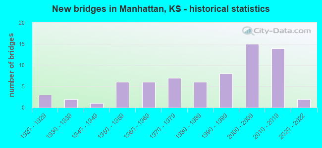
- New bridges - historical statistics
- 31920-1929
- 21930-1939
- 11940-1949
- 61950-1959
- 61960-1969
- 71970-1979
- 61980-1989
- 81990-1999
- 152000-2009
- 142010-2019
- 22020-2022
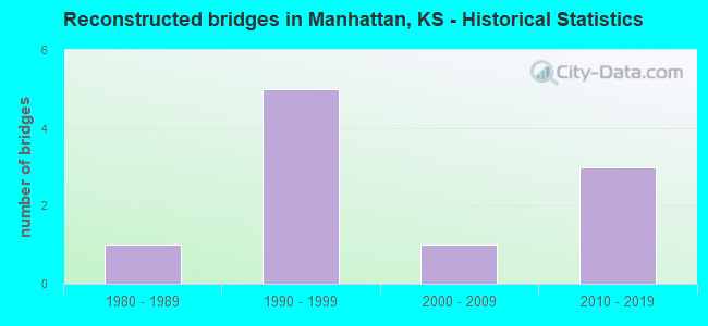
- Reconstructed bridges - Historical Statistics
- 11980-1989
- 51990-1999
- 12000-2009
- 32010-2019
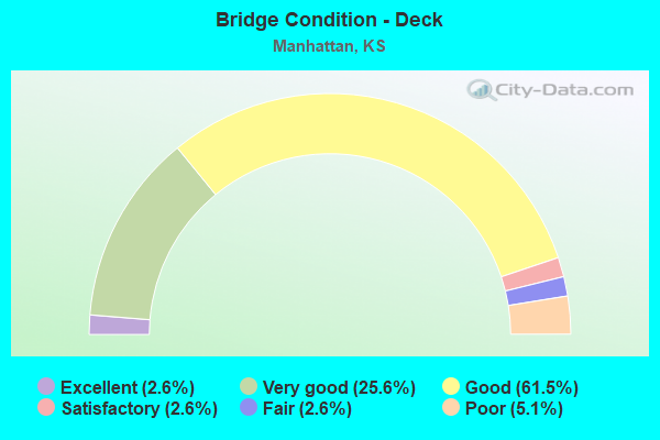
- Bridge Condition - Deck
- 2.6%Excellent
- 25.6%Very good
- 61.5%Good
- 2.6%Satisfactory
- 2.6%Fair
- 5.1%Poor
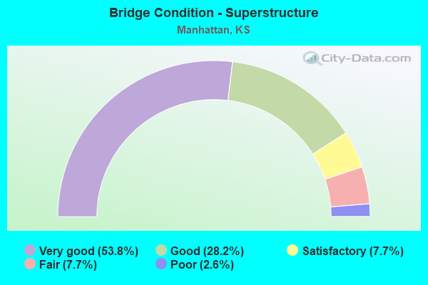
- Bridge Condition - Superstructure
- 53.8%Very good
- 28.2%Good
- 7.7%Satisfactory
- 7.7%Fair
- 2.6%Poor
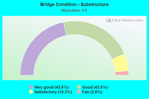
- Bridge Condition - Substructure
- 43.6%Very good
- 43.6%Good
- 10.3%Satisfactory
- 2.6%Fair
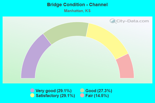
- Bridge Condition - Channel
- 29.1%Very good
- 27.3%Good
- 29.1%Satisfactory
- 14.5%Fair
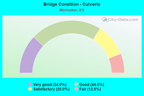
- Bridge Condition - Culverts
- 24.0%Very good
- 44.0%Good
- 20.0%Satisfactory
- 12.0%Fair
Find on map >> Show street view
Structure Number: 999901800810501, Location: 0.90 MI SE 2ND ST. (MNHT) (Lat: 39.174444, Lng: -96.554167), Route carried "on" structure: State highway 18, Year Built: 1996, Status: Open, Structure Length: 42.32m (138.85ft), Average Daily Traffic: 5,758 (year 2020), Truck Traffic: 6%, Average Future Daily Traffic: 7,166 (year 2041), Design Load: HS 25 or greater, Features Intersected: KANS R & UPRR & RILEY ST
Minimum Vertical Clearance: 30.47m (99.97ft), Kilometerpoint: 18.335, Lanes on structure: 4, Lanes under structure: 4, Base Highway Network: Yes, Owner: State Highway Agency, Approaching Roadway Width: 14.6m (47.9ft), Skew: 20 degrees, Material/Design: Steel continuous, Design/Construction: Stringer/Multi-beam, Number Of Spans In Main Unit: 10, Length of Maximum Span: 53.3m (174.9ft), Curb or Sidewalk Widths: Left: 1.8m (5.9ft), Right: 0.0m, Curb-To-Curb Width: 20.1m (65.9ft), Out-to-Out Width: 21.4m (70.2ft)
Condition: Deck: Good, Superstructure: Very good, Substructure: Good, Channel: Good, Operating Rating: 64.7 metric tons, Method Used To Determine Operating Rating: Load Factor (LF), Inventory Rating: 38.7 metric tons, Method Used To Determine Inventory Rating: Load Factor (LF), Structural Evaluation: Better than present minimum criteria, Deck Geometry: Better than present minimum criteria, Underclear: High priority of corrective action, Waterway Adequacy: Better than present minimum criteria, Approach Roadway Alignment: Equal to present desirable criteria, Length Of Structure Improvement: 138.84m (455.51ft), Designated Inspection Frequency: Every 24 months, Inspection Date: June 2021, Wearing Surface/Protective System: Wearing Surface: Low Slump Concrete, Deck Protection: Epoxy Coated Reinforcing
Find on map >> Show street view
Structure Number: 999901800810561, Location: 6.9 MI N K-57/K-18 JCT (Lat: 39.168889, Lng: -96.603611), Route carried "on" structure: State highway 18, Year Built: 2007, Year Reconstructed: 2019, Status: Open, Structure Length: 7.19m (23.59ft), Average Daily Traffic: 11,465 (year 2020), Truck Traffic: 2%, Average Future Daily Traffic: 17,036 (year 2041), Design Load: HL 93, Features Intersected: K-113 HWY
Minimum Vertical Clearance: 30.47m (99.97ft), Kilometerpoint: 13.646, Lanes on structure: 2, Lanes under structure: 5, Base Highway Network: Yes, Owner: State Highway Agency, Approaching Roadway Width: 12.2m (40.0ft), Material/Design: Prestressed concrete continuous, Design/Construction: Slab, Number Of Spans In Main Unit: 3, Length of Maximum Span: 28.0m (91.9ft), Curb-To-Curb Width: 12.2m (40.0ft), Out-to-Out Width: 12.8m (42.0ft)
Condition: Deck: Very good, Superstructure: Very good, Substructure: Very good, Operating Rating: 69.0 metric tons, Method Used To Determine Operating Rating: Load and Resistance Factor Rating (LRFR) rating reported by rating factor(RF) method using HL-93 loadings, Inventory Rating: 43.4 metric tons, Method Used To Determine Inventory Rating: Load and Resistance Factor Rating (LRFR) rating reported by rating factor(RF) method using HL-93 loadings, Structural Evaluation: Equal to present desirable criteria, Deck Geometry: Better than present minimum criteria, Underclear: Somewhat better than minimum adequacy, Approach Roadway Alignment: Equal to present desirable criteria, Length Of Structure Improvement: 23.59m (77.40ft), Designated Inspection Frequency: Every 24 months, Inspection Date: June 2021, Wearing Surface/Protective System: Wearing Surface: Monolithic Concrete, Deck Protection: Epoxy Coated Reinforcing
Find on map >> Show street view
Structure Number: 999901800810571, Location: Jct K-113/K18 EB (Lat: 39.168611, Lng: -96.603611), Route carried "on" structure: State highway 18, Year Built: 2004, Year Reconstructed: 2019, Status: Open, Structure Length: 7.19m (23.59ft), Average Daily Traffic: 11,465 (year 2020), Truck Traffic: 2%, Average Future Daily Traffic: 17,036 (year 2041), Design Load: HL 93, Features Intersected: K-113 HWY
Minimum Vertical Clearance: 30.47m (99.97ft), Kilometerpoint: 13.612, Lanes on structure: 2, Lanes under structure: 5, Base Highway Network: Yes, Owner: State Highway Agency, Approaching Roadway Width: 12.2m (40.0ft), Material/Design: Prestressed concrete continuous, Design/Construction: Slab, Number Of Spans In Main Unit: 3, Length of Maximum Span: 28.0m (91.9ft), Curb-To-Curb Width: 12.2m (40.0ft), Out-to-Out Width: 12.8m (42.0ft)
Condition: Deck: Very good, Superstructure: Very good, Substructure: Very good, Operating Rating: 69.0 metric tons, Method Used To Determine Operating Rating: Load and Resistance Factor Rating (LRFR) rating reported by rating factor(RF) method using HL-93 loadings, Inventory Rating: 43.4 metric tons, Method Used To Determine Inventory Rating: Load and Resistance Factor Rating (LRFR) rating reported by rating factor(RF) method using HL-93 loadings, Structural Evaluation: Equal to present desirable criteria, Deck Geometry: Better than present minimum criteria, Underclear: Somewhat better than minimum adequacy, Approach Roadway Alignment: Equal to present desirable criteria, Length Of Structure Improvement: 23.59m (77.40ft), Designated Inspection Frequency: Every 24 months, Inspection Date: June 2021, Wearing Surface/Protective System: Wearing Surface: Monolithic Concrete, Deck Protection: Epoxy Coated Reinforcing
Find on map >> Show street view
Structure Number: 999901800810751, Location: 1.56 MI NE OF K-114 (Lat: 39.129722, Lng: -96.673333), Route carried "on" structure: ServiceCounty highway 33, Year Built: 2013, Status: Open, Structure Length: 5.99m (19.65ft), Average Daily Traffic: 534 (year 2020), Truck Traffic: 1%, Average Future Daily Traffic: 13,894 (year 2041), Design Load: HL 93, Features Intersected: K18 HWY, Facility Carried by Structure: W 56TH AVE
Minimum Vertical Clearance: 30.47m (99.97ft), Kilometerpoint: 0.164, Lanes on structure: 4, Lanes under structure: 4, Owner: State Highway Agency, Approaching Roadway Width: 19.5m (64.0ft), Material/Design: Prestressed concrete continuous, Design/Construction: Stringer/Multi-beam, Number Of Spans In Main Unit: 2, Length of Maximum Span: 29.6m (97.1ft), Curb-To-Curb Width: 19.5m (64.0ft), Out-to-Out Width: 20.4m (66.9ft)
Condition: Deck: Very good, Superstructure: Very good, Substructure: Very good, Operating Rating: 63.2 metric tons, Method Used To Determine Operating Rating: Load and Resistance Factor Rating (LRFR) rating reported by rating factor(RF) method using HL-93 loadings, Inventory Rating: 37.9 metric tons, Method Used To Determine Inventory Rating: Load and Resistance Factor Rating (LRFR) rating reported by rating factor(RF) method using HL-93 loadings, Structural Evaluation: Equal to present desirable criteria, Deck Geometry: Better than present minimum criteria, Underclear: Equal to present minimum criteria, Approach Roadway Alignment: Meets minimum limits, Length Of Structure Improvement: 19.65m (64.47ft), Designated Inspection Frequency: Every 24 months, Inspection Date: June 2021, Wearing Surface/Protective System: Wearing Surface: Monolithic Concrete, Deck Protection: Epoxy Coated Reinforcing
Find on map >> Show street view
Structure Number: 999901800810771, Location: 2.22 MI NE OF K-114 (Lat: 39.136944, Lng: -96.663889), Route carried "on" structure: State highway 18, Year Built: 2013, Status: Open, Structure Length: 0.77m (2.53ft), Average Daily Traffic: 10,549 (year 2020), Truck Traffic: 3%, Average Future Daily Traffic: 15,675 (year 2041), Design Load: HS 25 or greater, Features Intersected: AIRPORT CHANNEL
Minimum Vertical Clearance: 30.47m (99.97ft), Kilometerpoint: 6.785, Lanes on structure: 6, Base Highway Network: Yes, Owner: State Highway Agency, Approaching Roadway Width: 19.5m (64.0ft), Skew: 20 degrees, Material/Design: Concrete, Design/Construction: Culvert, Number Of Spans In Main Unit: 3, Length of Maximum Span: 2.4m (7.9ft), Curb-To-Curb Width: 19.5m (64.0ft), Out-to-Out Width: 83.4m (273.6ft)
Condition: Channel: Very good, Culverts: Very good, Operating Rating: 69.1 metric tons, Method Used To Determine Operating Rating: Load Factor (LF), Inventory Rating: 41.4 metric tons, Method Used To Determine Inventory Rating: Load Factor (LF), Structural Evaluation: Equal to present desirable criteria, Deck Geometry: High priority of replacement, Waterway Adequacy: Equal to present desirable criteria, Approach Roadway Alignment: Equal to present desirable criteria, Length Of Structure Improvement: 2.53m (8.30ft), Designated Inspection Frequency: Every 24 months, Inspection Date: June 2021, Deck Structure Type: Concrete Cast-file-Place, Wearing Surface/Protective System: Wearing Surface: Monolithic Concrete
Find on map >> Show street view
Structure Number: 999901800810781, Location: 3.39 MI NE OF K-114 (Lat: 39.147222, Lng: -96.649722), Route carried "on" structure: State highway 18, Year Built: 2013, Status: Open, Structure Length: 4.95m (16.24ft), Average Daily Traffic: 10,549 (year 2020), Truck Traffic: 3%, Average Future Daily Traffic: 15,675 (year 2041), Design Load: HL 93, Features Intersected: EUREKA VALLEY TRIBUTARY
Minimum Vertical Clearance: 30.47m (99.97ft), Kilometerpoint: 8.544, Lanes on structure: 2, Base Highway Network: Yes, Owner: State Highway Agency, Approaching Roadway Width: 12.3m (40.4ft), Material/Design: Concrete continuous, Design/Construction: Slab, Number Of Spans In Main Unit: 3, Length of Maximum Span: 19.5m (64.0ft), Curb-To-Curb Width: 12.3m (40.4ft), Out-to-Out Width: 13.0m (42.7ft)
Condition: Deck: Good, Superstructure: Very good, Substructure: Very good, Channel: Very good, Operating Rating: 60.6 metric tons, Method Used To Determine Operating Rating: Load and Resistance Factor Rating (LRFR) rating reported by rating factor(RF) method using HL-93 loadings, Inventory Rating: 47.0 metric tons, Method Used To Determine Inventory Rating: Load and Resistance Factor Rating (LRFR) rating reported by rating factor(RF) method using HL-93 loadings, Structural Evaluation: Equal to present desirable criteria, Deck Geometry: Better than present minimum criteria, Waterway Adequacy: Equal to present desirable criteria, Approach Roadway Alignment: Equal to present desirable criteria, Length Of Structure Improvement: 16.25m (53.31ft), Designated Inspection Frequency: Every 24 months, Inspection Date: June 2021, Deck Structure Type: Concrete Cast-file-Place, Wearing Surface/Protective System: Wearing Surface: Monolithic Concrete, Deck Protection: Epoxy Coated Reinforcing
Find on map >> Show street view
Structure Number: 999901800810791, Location: 3.39 MI NE OF K-114 (Lat: 39.146944, Lng: -96.649444), Route carried "on" structure: State highway 18, Year Built: 2013, Status: Open, Structure Length: 4.95m (16.24ft), Average Daily Traffic: 10,549 (year 2020), Truck Traffic: 3%, Average Future Daily Traffic: 15,675 (year 2041), Design Load: HL 93, Features Intersected: EUREKA VALLEY TRIBUTARY
Minimum Vertical Clearance: 30.47m (99.97ft), Kilometerpoint: 8.536, Lanes on structure: 2, Base Highway Network: Yes, Owner: State Highway Agency, Approaching Roadway Width: 12.3m (40.4ft), Material/Design: Concrete continuous, Design/Construction: Slab, Number Of Spans In Main Unit: 3, Length of Maximum Span: 19.5m (64.0ft), Curb-To-Curb Width: 12.3m (40.4ft), Out-to-Out Width: 13.0m (42.7ft)
Condition: Deck: Very good, Superstructure: Very good, Substructure: Very good, Channel: Very good, Operating Rating: 50.9 metric tons, Method Used To Determine Operating Rating: Load and Resistance Factor Rating (LRFR) rating reported by rating factor(RF) method using HL-93 loadings, Inventory Rating: 35.3 metric tons, Method Used To Determine Inventory Rating: Load and Resistance Factor Rating (LRFR) rating reported by rating factor(RF) method using HL-93 loadings, Structural Evaluation: Equal to present desirable criteria, Deck Geometry: Better than present minimum criteria, Waterway Adequacy: Equal to present desirable criteria, Approach Roadway Alignment: Equal to present desirable criteria, Length Of Structure Improvement: 16.25m (53.31ft), Designated Inspection Frequency: Every 24 months, Inspection Date: June 2021, Wearing Surface/Protective System: Wearing Surface: Monolithic Concrete, Deck Protection: Epoxy Coated Reinforcing
Find on map >> Show street view
Structure Number: 999901800810821, Location: 3.97 MI E OF K-114 JCT (Lat: 39.154167, Lng: -96.643611), Route carried "on" structure: County highway 3828, Year Built: 2013, Status: Open, Structure Length: 11.42m (37.47ft), Average Daily Traffic: 7,667 (year 2020), Truck Traffic: 7%, Average Future Daily Traffic: 6,271 (year 2041), Design Load: HL 93, Features Intersected: K18 HWY, Facility Carried by Structure: SCENIC DRIVE
Minimum Vertical Clearance: 30.47m (99.97ft), Kilometerpoint: 0.349, Lanes on structure: 4, Lanes under structure: 4, Owner: State Highway Agency, Approaching Roadway Width: 17.1m (56.1ft), Skew: 22 degrees, Material/Design: Prestressed concrete continuous, Design/Construction: Stringer/Multi-beam, Number Of Spans In Main Unit: 4, Length of Maximum Span: 30.5m (100.1ft), Curb-To-Curb Width: 17.1m (56.1ft), Out-to-Out Width: 19.4m (63.6ft)
Condition: Deck: Good, Superstructure: Very good, Substructure: Very good, Operating Rating: 64.2 metric tons, Method Used To Determine Operating Rating: Load and Resistance Factor Rating (LRFR) rating reported by rating factor(RF) method using HL-93 loadings, Inventory Rating: 38.6 metric tons, Method Used To Determine Inventory Rating: Load and Resistance Factor Rating (LRFR) rating reported by rating factor(RF) method using HL-93 loadings, Structural Evaluation: Equal to present desirable criteria, Deck Geometry: Somewhat better than minimum adequacy, Underclear: Better than present minimum criteria, Approach Roadway Alignment: Somewhat better than minimum adequacy, Length Of Structure Improvement: 37.48m (122.97ft), Designated Inspection Frequency: Every 24 months, Inspection Date: June 2021, Wearing Surface/Protective System: Wearing Surface: Epoxy Overlay, Deck Protection: Epoxy Coated Reinforcing
Find on map >> Show street view
Structure Number: 999901800810831, Location: 4.74 MI E OF K-114 JCT (Lat: 39.158333, Lng: -96.632500), Route carried "on" structure: State highway 18, Year Built: 2013, Status: Open, Structure Length: 0.95m (3.12ft), Average Daily Traffic: 10,102 (year 2020), Truck Traffic: 3%, Average Future Daily Traffic: 15,011 (year 2041), Design Load: HS 25 or greater, Features Intersected: KANSAS RIVER DR
Minimum Vertical Clearance: 30.47m (99.97ft), Kilometerpoint: 10.543, Lanes on structure: 4, Base Highway Network: Yes, Owner: State Highway Agency, Approaching Roadway Width: 17.1m (56.1ft), Skew: 14 degrees, Material/Design: Concrete, Design/Construction: Culvert, Number Of Spans In Main Unit: 3, Length of Maximum Span: 3.0m (9.8ft), Curb-To-Curb Width: 17.1m (56.1ft), Out-to-Out Width: 76.5m (251.0ft)
Condition: Channel: Good, Culverts: Good, Inventory Rating: 12.2 metric tons, Method Used To Determine Inventory Rating: Load Factor (LF), Structural Evaluation: High priority of corrective action, Deck Geometry: High priority of corrective action, Waterway Adequacy: Equal to present desirable criteria, Approach Roadway Alignment: Equal to present desirable criteria, Length Of Structure Improvement: 3.13m (10.27ft), Designated Inspection Frequency: Every 24 months, Inspection Date: June 2021, Deck Structure Type: Concrete Cast-file-Place, Wearing Surface/Protective System: Wearing Surface: Monolithic Concrete, Deck Protection: Epoxy Coated Reinforcing
Find on map >> Show street view
Structure Number: 999901800810841, Location: 5.77 MI NE OF K-114 (Lat: 39.166667, Lng: -96.616111), Route carried "on" structure: City street 3856, Year Built: 2014, Status: Open, Structure Length: 6.05m (19.85ft), Average Daily Traffic: 2,780 (year 2020), Truck Traffic: 3%, Average Future Daily Traffic: 3,895 (year 2041), Design Load: HL 93, Features Intersected: K18 HWY, Facility Carried by Structure: MILLER PKWY/DAVIS
Minimum Vertical Clearance: 30.47m (99.97ft), Kilometerpoint: 3.442, Lanes on structure: 2, Lanes under structure: 4, Owner: State Highway Agency, Approaching Roadway Width: 17.7m (58.1ft), Material/Design: Steel continuous, Design/Construction: Stringer/Multi-beam, Number Of Spans In Main Unit: 2, Length of Maximum Span: 29.9m (98.1ft), Curb or Sidewalk Widths: Left: 1.8m (5.9ft), Right: 1.8m (5.9ft), Curb-To-Curb Width: 17.7m (58.1ft), Out-to-Out Width: 23.2m (76.1ft)
Condition: Deck: Good, Superstructure: Very good, Substructure: Very good, Operating Rating: 50.9 metric tons, Method Used To Determine Operating Rating: Load and Resistance Factor Rating (LRFR) rating reported by rating factor(RF) method using HL-93 loadings, Inventory Rating: 39.2 metric tons, Method Used To Determine Inventory Rating: Load and Resistance Factor Rating (LRFR) rating reported by rating factor(RF) method using HL-93 loadings, Structural Evaluation: Equal to present desirable criteria, Deck Geometry: Superior to present desirable criteria, Underclear: Equal to present minimum criteria, Approach Roadway Alignment: Somewhat better than minimum adequacy, Length Of Structure Improvement: 19.85m (65.12ft), Designated Inspection Frequency: Every 24 months, Inspection Date: June 2021, Wearing Surface/Protective System: Wearing Surface: Monolithic Concrete, Deck Protection: Epoxy Coated Reinforcing
Find on map >> Show street view
Structure Number: 999901800810901, Location: 0.56 MI E K113 (Lat: 39.170278, Lng: -96.593889), Route carried "on" structure: State highway 18, Year Built: 2021, Status: Open, Structure Length: 7.36m (24.15ft), Average Daily Traffic: 13,132 (year 2020), Truck Traffic: 3%, Average Future Daily Traffic: 16,024 (year 2041), Design Load: HL 93, Features Intersected: WILDCAT CREEK
Minimum Vertical Clearance: 30.47m (99.97ft), Kilometerpoint: 14.553, Lanes on structure: 4, Base Highway Network: Yes, Owner: State Highway Agency, Approaching Roadway Width: 21.3m (69.9ft), Skew: 3 degrees, Material/Design: Steel continuous, Design/Construction: Stringer/Multi-beam, Number Of Spans In Main Unit: 3, Length of Maximum Span: 31.1m (102.0ft), Curb or Sidewalk Widths: Left: 3.7m (12.1ft), Right: 0.0m, Curb-To-Curb Width: 24.7m (81.0ft), Out-to-Out Width: 25.3m (83.0ft)
Condition: Deck: Very good, Superstructure: Very good, Substructure: Very good, Channel: Very good, Operating Rating: 61.6 metric tons, Method Used To Determine Operating Rating: Load and Resistance Factor Rating (LRFR) rating reported by rating factor(RF) method using HL-93 loadings, Inventory Rating: 47.6 metric tons, Method Used To Determine Inventory Rating: Load and Resistance Factor Rating (LRFR) rating reported by rating factor(RF) method using HL-93 loadings, Structural Evaluation: Equal to present desirable criteria, Deck Geometry: Superior to present desirable criteria, Waterway Adequacy: Equal to present desirable criteria, Approach Roadway Alignment: Meets minimum limits, Designated Inspection Frequency: Every 24 months, Inspection Date: June 2021, Wearing Surface/Protective System: Wearing Surface: Monolithic Concrete, Deck Protection: Epoxy Coated Reinforcing
Find on map >> Show street view
Structure Number: 999902400750011, Location: 1.35 MI E RILEY COLN, WB (Lat: 39.192500, Lng: -96.537500), Route carried "on" structure: US 24, Year Built: 1960, Year Reconstructed: 1991, Status: Open, Structure Length: 12.79m (41.96ft), Average Daily Traffic: 12,920 (year 2020), Truck Traffic: 3%, Average Future Daily Traffic: 19,966 (year 2041), Design Load: H 20, Features Intersected: BIG BLUE RIVER
Minimum Vertical Clearance: 30.47m (99.97ft), Kilometerpoint: 2.157, Lanes on structure: 2, Base Highway Network: Yes, Owner: State Highway Agency, Approaching Roadway Width: 12.2m (40.0ft), Material/Design: Steel continuous, Design/Construction: Stringer/Multi-beam, Number Of Spans In Main Unit: 3, Length of Maximum Span: 48.8m (160.1ft), Curb-To-Curb Width: 12.2m (40.0ft), Out-to-Out Width: 12.8m (42.0ft)
Condition: Deck: Good, Superstructure: Good, Substructure: Good, Channel: Satisfactory, Operating Rating: 43.0 metric tons, Method Used To Determine Operating Rating: Load Factor (LF), Inventory Rating: 25.8 metric tons, Method Used To Determine Inventory Rating: Load Factor (LF), Structural Evaluation: Equal to present minimum criteria, Deck Geometry: Better than present minimum criteria, Waterway Adequacy: Somewhat better than minimum adequacy, Approach Roadway Alignment: Equal to present desirable criteria, Length Of Structure Improvement: 41.95m (137.63ft), Designated Inspection Frequency: Every 24 months, Underwater Inspection Frequency: Every 48 months, Inspection Date: June 2021, Underwater Inspection Date: July 2018, Deck Structure Type: Concrete Cast-file-Place, Wearing Surface/Protective System: Wearing Surface: Low Slump Concrete
Find on map >> Show street view
Structure Number: 999902400750041, Location: 4.69 MI E RILEY COLN (Lat: 39.197500, Lng: -96.475833), Route carried "on" structure: US 24, Year Built: 1950, Year Reconstructed: 1996, Status: Open, Structure Length: 0.63m (2.07ft), Average Daily Traffic: 5,717 (year 2020), Truck Traffic: 6%, Average Future Daily Traffic: 8,835 (year 2041), Design Load: H 20, Features Intersected: SAND CREEK
Minimum Vertical Clearance: 30.47m (99.97ft), Kilometerpoint: 7.593, Lanes on structure: 4, Base Highway Network: Yes, Owner: State Highway Agency, Approaching Roadway Width: 12.8m (42.0ft), Skew: 20 degrees, Material/Design: Concrete, Design/Construction: Culvert, Number Of Spans In Main Unit: 2, Length of Maximum Span: 3.0m (9.8ft), Curb-To-Curb Width: 24.4m (80.1ft), Out-to-Out Width: 67.4m (221.1ft)
Condition: Channel: Fair, Culverts: Good, Operating Rating: 49.0 metric tons, Method Used To Determine Operating Rating: Load Factor (LF), Inventory Rating: 29.0 metric tons, Method Used To Determine Inventory Rating: Load Factor (LF), Structural Evaluation: Better than present minimum criteria, Deck Geometry: Superior to present desirable criteria, Waterway Adequacy: Somewhat better than minimum adequacy, Approach Roadway Alignment: Equal to present desirable criteria, Length Of Structure Improvement: 2.08m (6.82ft), Designated Inspection Frequency: Every 24 months, Inspection Date: June 2021, Deck Structure Type: Concrete Cast-file-Place, Wearing Surface/Protective System: Wearing Surface: Monolithic Concrete
Find on map >> Show street view
Structure Number: 999902400750491, Location: 1.34 MI E RILEY COLN, EB (Lat: 39.192222, Lng: -96.537500), Route carried "on" structure: US 24, Year Built: 1991, Status: Open, Structure Length: 12.79m (41.96ft), Average Daily Traffic: 12,920 (year 2020), Truck Traffic: 3%, Average Future Daily Traffic: 19,966 (year 2041), Design Load: HS 20, Features Intersected: BIG BLUE RIVER
Minimum Vertical Clearance: 30.47m (99.97ft), Kilometerpoint: 2.166, Lanes on structure: 2, Base Highway Network: Yes, Owner: State Highway Agency, Approaching Roadway Width: 12.2m (40.0ft), Material/Design: Steel continuous, Design/Construction: Stringer/Multi-beam, Number Of Spans In Main Unit: 3, Length of Maximum Span: 48.8m (160.1ft), Curb-To-Curb Width: 12.2m (40.0ft), Out-to-Out Width: 12.8m (42.0ft)
Condition: Deck: Good, Superstructure: Good, Substructure: Good, Channel: Good, Operating Rating: 84.3 metric tons, Method Used To Determine Operating Rating: Load Factor (LF), Inventory Rating: 50.4 metric tons, Method Used To Determine Inventory Rating: Load Factor (LF), Structural Evaluation: Better than present minimum criteria, Deck Geometry: Better than present minimum criteria, Waterway Adequacy: Somewhat better than minimum adequacy, Approach Roadway Alignment: Equal to present desirable criteria, Length Of Structure Improvement: 41.95m (137.63ft), Designated Inspection Frequency: Every 24 months, Underwater Inspection Frequency: Every 48 months, Inspection Date: June 2021, Underwater Inspection Date: July 2018, Wearing Surface/Protective System: Wearing Surface: Low Slump Concrete, Deck Protection: Epoxy Coated Reinforcing
Find on map >> Show street view
Structure Number: 999902400810101, Location: 0.61 MI SE NJCT K-13 (Lat: 39.244444, Lng: -96.594722), Route carried "on" structure: US 24, Year Built: 1958, Status: Open, Structure Length: 3.12m (10.24ft), Average Daily Traffic: 3,554 (year 2020), Truck Traffic: 3%, Average Future Daily Traffic: 5,281 (year 2041), Design Load: HS 20, Features Intersected: PHIEL CREEK
Minimum Vertical Clearance: 30.47m (99.97ft), Kilometerpoint: 41.861, Lanes on structure: 2, Base Highway Network: Yes, Owner: State Highway Agency, Approaching Roadway Width: 12.2m (40.0ft), Material/Design: Concrete continuous, Design/Construction: Slab, Number Of Spans In Main Unit: 3, Length of Maximum Span: 12.2m (40.0ft), Curb-To-Curb Width: 8.5m (27.9ft), Out-to-Out Width: 10.2m (33.5ft)
Condition: Deck: Good, Superstructure: Satisfactory, Substructure: Good, Channel: Good, Operating Rating: 49.9 metric tons, Method Used To Determine Operating Rating: Load Factor (LF), Inventory Rating: 29.9 metric tons, Method Used To Determine Inventory Rating: Load Factor (LF), Structural Evaluation: Equal to present minimum criteria, Deck Geometry: High priority of corrective action, Waterway Adequacy: Equal to present desirable criteria, Approach Roadway Alignment: Equal to present minimum criteria, Length Of Structure Improvement: 10.25m (33.63ft), Designated Inspection Frequency: Every 24 months, Inspection Date: June 2021, Deck Structure Type: Concrete Cast-file-Place, Wearing Surface/Protective System: Wearing Surface: Low Slump Concrete
Find on map >> Show street view
Structure Number: 999902400810111, Location: 2.77 MI SE NJCT K13 (Lat: 39.218611, Lng: -96.578889), Route carried "on" structure: US 24, Year Built: 1942, Year Reconstructed: 2011, Status: Open, Structure Length: 1.83m (6.00ft), Average Daily Traffic: 3,554 (year 2020), Truck Traffic: 3%, Average Future Daily Traffic: 5,281 (year 2041), Design Load: HS 25 or greater, Features Intersected: BIG BLUE RIVER DRAINAGE
Minimum Vertical Clearance: 30.47m (99.97ft), Kilometerpoint: 45.044, Lanes on structure: 8, Base Highway Network: Yes, Owner: State Highway Agency, Approaching Roadway Width: 37.8m (124.0ft), Skew: 13 degrees, Material/Design: Concrete, Design/Construction: Culvert, Number Of Spans In Main Unit: 5, Length of Maximum Span: 3.0m (9.8ft), Curb or Sidewalk Widths: Left: 0.0m, Right: 3.1m (10.2ft), Curb-To-Curb Width: 32.9m (107.9ft), Out-to-Out Width: 86.2m (282.8ft)
Condition: Channel: Satisfactory, Culverts: Good, Operating Rating: 29.4 metric tons, Method Used To Determine Operating Rating: Load Factor (LF), Inventory Rating: 17.6 metric tons, Method Used To Determine Inventory Rating: Load Factor (LF), Structural Evaluation: Meets minimum limits, Deck Geometry: Somewhat better than minimum adequacy, Waterway Adequacy: Somewhat better than minimum adequacy, Approach Roadway Alignment: Equal to present desirable criteria, Length Of Structure Improvement: 6.00m (19.69ft), Designated Inspection Frequency: Every 24 months, Inspection Date: June 2021, Deck Structure Type: Concrete Cast-file-Place, Wearing Surface/Protective System: Wearing Surface: Bituminous
Find on map >> Show street view
Structure Number: 999902400810531, Location: 0.62 MI SE N JCT K-13 (Lat: 39.244444, Lng: -96.595000), Route carried "on" structure: US 24, Year Built: 2001, Status: Open, Structure Length: 3.85m (12.63ft), Average Daily Traffic: 3,554 (year 2020), Truck Traffic: 3%, Average Future Daily Traffic: 5,281 (year 2041), Design Load: HS 25 or greater, Features Intersected: PHIEL CREEK
Minimum Vertical Clearance: 30.47m (99.97ft), Kilometerpoint: 41.853, Lanes on structure: 2, Base Highway Network: Yes, Owner: State Highway Agency, Approaching Roadway Width: 12.2m (40.0ft), Material/Design: Steel, Design/Construction: Stringer/Multi-beam, Number Of Spans In Main Unit: 1, Length of Maximum Span: 37.8m (124.0ft), Curb-To-Curb Width: 12.2m (40.0ft), Out-to-Out Width: 12.8m (42.0ft)
Condition: Deck: Good, Superstructure: Very good, Substructure: Good, Channel: Good, Operating Rating: 63.5 metric tons, Method Used To Determine Operating Rating: Load Factor (LF), Inventory Rating: 38.1 metric tons, Method Used To Determine Inventory Rating: Load Factor (LF), Structural Evaluation: Better than present minimum criteria, Deck Geometry: Better than present minimum criteria, Waterway Adequacy: Equal to present desirable criteria, Approach Roadway Alignment: Somewhat better than minimum adequacy, Length Of Structure Improvement: 12.63m (41.44ft), Designated Inspection Frequency: Every 24 months, Inspection Date: June 2021, Wearing Surface/Protective System: Wearing Surface: Low Slump Concrete, Deck Protection: Epoxy Coated Reinforcing
Find on map >> Show street view
Structure Number: 999911300810371, Location: 1.55 MI N K18 (Lat: 39.189444, Lng: -96.611667), Route carried "on" structure: State highway 113, Year Built: 1968, Year Reconstructed: 1996, Status: Open, Structure Length: 4.86m (15.94ft), Average Daily Traffic: 16,163 (year 2020), Truck Traffic: 2%, Average Future Daily Traffic: 24,017 (year 2041), Design Load: HS 20, Features Intersected: ANDERSON AVE
Minimum Vertical Clearance: 30.47m (99.97ft), Kilometerpoint: 2.977, Lanes on structure: 4, Lanes under structure: 5, Base Highway Network: Yes, Owner: State Highway Agency, Approaching Roadway Width: 20.7m (67.9ft), Material/Design: Concrete continuous, Design/Construction: Slab, Number Of Spans In Main Unit: 3, Length of Maximum Span: 19.2m (63.0ft), Curb-To-Curb Width: 20.7m (67.9ft), Out-to-Out Width: 21.5m (70.5ft)
Condition: Deck: Good, Superstructure: Good, Substructure: Good, Operating Rating: 63.5 metric tons, Method Used To Determine Operating Rating: Load Factor (LF), Inventory Rating: 38.1 metric tons, Method Used To Determine Inventory Rating: Load Factor (LF), Structural Evaluation: Better than present minimum criteria, Deck Geometry: Superior to present desirable criteria, Underclear: High priority of corrective action, Approach Roadway Alignment: Meets minimum limits, Length Of Structure Improvement: 15.95m (52.33ft), Designated Inspection Frequency: Every 24 months, Inspection Date: June 2021, Deck Structure Type: Concrete Cast-file-Place, Wearing Surface/Protective System: Wearing Surface: Epoxy Overlay
Find on map >> Show street view
Structure Number: 999911300810401, Location: 2.56 MI N K18 (Lat: 39.203611, Lng: -96.615833), Route carried "on" structure: State highway 113, Year Built: 1972, Status: Open, Structure Length: 6.24m (20.47ft), Average Daily Traffic: 8,081 (year 2020), Truck Traffic: 2%, Average Future Daily Traffic: 12,008 (year 2041), Design Load: HS 20, Features Intersected: KIMBALL AVE
Minimum Vertical Clearance: 30.47m (99.97ft), Kilometerpoint: 4.424, Lanes on structure: 2, Lanes under structure: 4, Base Highway Network: Yes, Owner: State Highway Agency, Approaching Roadway Width: 13.4m (44.0ft), Skew: 6 degrees, Material/Design: Concrete continuous, Design/Construction: Slab, Number Of Spans In Main Unit: 4, Length of Maximum Span: 18.3m (60.0ft), Curb-To-Curb Width: 13.4m (44.0ft), Out-to-Out Width: 14.1m (46.3ft)
Condition: Deck: Good, Superstructure: Good, Substructure: Good, Operating Rating: 64.4 metric tons, Method Used To Determine Operating Rating: Load Factor (LF), Inventory Rating: 38.1 metric tons, Method Used To Determine Inventory Rating: Load Factor (LF), Structural Evaluation: Better than present minimum criteria, Deck Geometry: Superior to present desirable criteria, Underclear: Equal to present minimum criteria, Approach Roadway Alignment: Equal to present desirable criteria, Length Of Structure Improvement: 20.48m (67.19ft), Designated Inspection Frequency: Every 24 months, Inspection Date: June 2021, Deck Structure Type: Concrete Cast-file-Place, Wearing Surface/Protective System: Wearing Surface: Low Slump Concrete
Find on map >> Show street view
Structure Number: 999911300810491, Location: 1.21 MI N K-18 (Lat: 39.184444, Lng: -96.610556), Route carried "on" structure: State highway 113, Year Built: 1993, Status: Open, Structure Length: 8.13m (26.67ft), Average Daily Traffic: 19,093 (year 2020), Truck Traffic: 2%, Average Future Daily Traffic: 28,371 (year 2041), Design Load: HS 20, Features Intersected: WILDCAT CREEK
Minimum Vertical Clearance: 30.47m (99.97ft), Kilometerpoint: 2.414, Lanes on structure: 4, Base Highway Network: Yes, Owner: State Highway Agency, Approaching Roadway Width: 20.7m (67.9ft), Skew: 1 degrees, Material/Design: Steel continuous, Design/Construction: Stringer/Multi-beam, Number Of Spans In Main Unit: 3, Length of Maximum Span: 33.5m (109.9ft), Curb-To-Curb Width: 20.7m (67.9ft), Out-to-Out Width: 21.5m (70.5ft)
Condition: Deck: Good, Superstructure: Very good, Substructure: Good, Channel: Good, Operating Rating: 65.3 metric tons, Method Used To Determine Operating Rating: Load Factor (LF), Inventory Rating: 39.0 metric tons, Method Used To Determine Inventory Rating: Load Factor (LF), Structural Evaluation: Better than present minimum criteria, Deck Geometry: Superior to present desirable criteria, Waterway Adequacy: Equal to present desirable criteria, Approach Roadway Alignment: Meets minimum limits, Length Of Structure Improvement: 26.66m (87.47ft), Designated Inspection Frequency: Every 24 months, Inspection Date: June 2021, Wearing Surface/Protective System: Wearing Surface: Epoxy Overlay, Deck Protection: Epoxy Coated Reinforcing
Find on map >> Show street view
Structure Number: 999911300810511, Location: 2.55 MI N K-18 (Lat: 39.203611, Lng: -96.615556), Route carried "on" structure: State highway 113, Year Built: 1996, Status: Open, Structure Length: 6.26m (20.54ft), Average Daily Traffic: 4,783 (year 2020), Truck Traffic: 3%, Average Future Daily Traffic: 7,107 (year 2041), Design Load: HS 20, Features Intersected: KIMBALL AVE
Minimum Vertical Clearance: 30.47m (99.97ft), Kilometerpoint: 4.598, Lanes on structure: 2, Lanes under structure: 4, Base Highway Network: Yes, Owner: State Highway Agency, Approaching Roadway Width: 12.2m (40.0ft), Skew: 2 degrees, Material/Design: Concrete continuous, Design/Construction: Slab, Number Of Spans In Main Unit: 4, Length of Maximum Span: 18.4m (60.4ft), Curb-To-Curb Width: 11.6m (38.1ft), Out-to-Out Width: 12.2m (40.0ft)
Condition: Deck: Good, Superstructure: Very good, Substructure: Good, Operating Rating: 68.9 metric tons, Method Used To Determine Operating Rating: Load Factor (LF), Inventory Rating: 41.7 metric tons, Method Used To Determine Inventory Rating: Load Factor (LF), Structural Evaluation: Better than present minimum criteria, Deck Geometry: Better than present minimum criteria, Underclear: Equal to present minimum criteria, Approach Roadway Alignment: Equal to present desirable criteria, Length Of Structure Improvement: 20.55m (67.42ft), Designated Inspection Frequency: Every 24 months, Inspection Date: June 2021, Wearing Surface/Protective System: Wearing Surface: Low Slump Concrete, Deck Protection: Epoxy Coated Reinforcing
Find on map >> Show street view
Structure Number: CEPMRKKS0000004, Location: MANHATTAN, KS. (Lat: 39.263494, Lng: -96.577789), Route carried "on" structure: State highway 13, Year Built: 1960, Year Reconstructed: 2019, Status: Open, Structure Length: 25.56m (83.86ft), Average Daily Traffic: 1,770 (year 2020), Truck Traffic: 10%, Average Future Daily Traffic: 1,000 (year 2038), Design Load: HS 20+Mod, Features Intersected: TUTTLE CREEK LAKE
Minimum Vertical Clearance: 30+ m (98+ ft), Kilometerpoint: 0.000, Lanes on structure: 2, Base Highway Network: Yes, Owner: Corps of Engineers (Civil), Approaching Roadway Width: 8.5m (27.9ft), Material/Design: Steel, Design/Construction: Girder and Floorbeam System, Number Of Spans In Main Unit: 18, Length of Maximum Span: 12.8m (42.0ft), Curb or Sidewalk Widths: Left: 0.0m, Right: 1.4m (4.6ft), Curb-To-Curb Width: 8.5m (27.9ft), Out-to-Out Width: 10.8m (35.4ft)
Condition: Deck: Excellent, Superstructure: Fair, Substructure: Satisfactory, Channel: Very good, Operating Rating: 32.7 metric tons, Method Used To Determine Operating Rating: Load and Resistance Factor Rating (LRFR) rating reported by rating factor(RF) method using HL-93 loadings, Inventory Rating: 25.3 metric tons, Method Used To Determine Inventory Rating: Load and Resistance Factor Rating (LRFR) rating reported by rating factor(RF) method using HL-93 loadings, Structural Evaluation: Somewhat better than minimum adequacy, Deck Geometry: Somewhat better than minimum adequacy, Waterway Adequacy: Superior to present desirable criteria, Approach Roadway Alignment: Equal to present desirable criteria, Length Of Structure Improvement: 34.79m (114.14ft), Designated Inspection Frequency: Every 24 months, Critical Feature Inspection Frequency: Every 24 months, Inspection Date: April 2021, Critical Feature Inspection Date: April 2021, Bridge Improvement Cost: $1,935,000, Roadway Improvement Cost: $194,000, Total Project Cost: $2,903,000 ( Estimate for 2021), Deck Structure Type: Concrete Cast-file-Place, Wearing Surface/Protective System: Wearing Surface: Monolithic Concrete
Find on map >> Show street view
Structure Number: CEPNWKKS0000055, Location: MANHATTAN, KS (Lat: 39.248644, Lng: -96.598461), Route carried "on" structure: ServiceOther road , Year Built: 1950, Status: Open, Structure Length: 0.63m (2.07ft), Average Daily Traffic: 300 (year 2015), Truck Traffic: 10%, Average Future Daily Traffic: 300 (year 2040), Design Load: HS 20, Features Intersected: TUTTLE-WOLF CREEK-BOX, Facility Carried by Structure: SERVICE ROAD
Minimum Vertical Clearance: 30+ m (98+ ft), Kilometerpoint: 0.000, Lanes on structure: 2, Owner: Corps of Engineers (Civil), Approaching Roadway Width: 7.5m (24.6ft), Material/Design: Concrete continuous, Design/Construction: Culvert, Number Of Spans In Main Unit: 2, Length of Maximum Span: 3.1m (10.2ft), Curb-To-Curb Width: 7.0m (23.0ft), Out-to-Out Width: 14.0m (45.9ft)
Condition: Channel: Fair, Culverts: Satisfactory, Operating Rating: 42.0 metric tons, Method Used To Determine Operating Rating: Field evaluation and documented engineering judgment, Inventory Rating: 32.4 metric tons, Method Used To Determine Inventory Rating: Field evaluation and documented engineering judgment, Structural Evaluation: Equal to present minimum criteria, Deck Geometry: Meets minimum limits, Waterway Adequacy: Somewhat better than minimum adequacy, Approach Roadway Alignment: Somewhat better than minimum adequacy, Length Of Structure Improvement: 1.25m (4.10ft), Designated Inspection Frequency: Every 24 months, Inspection Date: April 2021, Bridge Improvement Cost: $93,000, Roadway Improvement Cost: $9,000, Total Project Cost: $140,000 ( Estimate for 2021), Deck Structure Type: Concrete Cast-file-Place, Wearing Surface/Protective System: Wearing Surface: Bituminous
Find on map >> Show street view
Structure Number: 999901800810501, Location: 0.90 MI SE 2ND ST. (MNHT) (Lat: 39.174444, Lng: -96.554167), Route carried "under" structure: State highway 18, Year Built: 1996, Structure Length: 0. m, Average Daily Traffic: 10,886 (year 2020), Truck Traffic: 2%, Features Intersected: KANS R & UPRR & RILEY ST
Minimum Vertical Clearance: 5.94m (19.49ft), Kilometerpoint: 0.161, Lanes on structure: 4, Lanes under structure: 4, Material/Design: Steel continuous, Design/Construction: Stringer/Multi-beam, Length of Maximum Span: 53.3m (174.9ft)
Find on map >> Show street view
Structure Number: 999901800810561, Location: 6.9 MI N K-57/K-18 JCT (Lat: 39.168889, Lng: -96.603611), Route carried "under" structure: State highway 113, Year Built: 2007, Structure Length: 0. m, Average Daily Traffic: 9,655 (year 2020), Truck Traffic: 2%, Features Intersected: K-113 HWY, Facility Carried by Structure: K-18 HWY, WB
Minimum Vertical Clearance: 5.27m (17.29ft), Kilometerpoint: 0.486, Lanes on structure: 2, Lanes under structure: 5, Material/Design: Prestressed concrete continuous, Design/Construction: Slab, Length of Maximum Span: 28.0m (91.9ft)
Find on map >> Show street view
Structure Number: 999901800810571, Location: Jct K-113/K18 EB (Lat: 39.168611, Lng: -96.603611), Route carried "under" structure: State highway 113, Year Built: 2004, Structure Length: 0. m, Average Daily Traffic: 9,655 (year 2020), Truck Traffic: 2%, Features Intersected: K-113 HWY, Facility Carried by Structure: K-18 HWY, EB
Minimum Vertical Clearance: 4.90m (16.08ft), Kilometerpoint: 0.459, Lanes on structure: 2, Lanes under structure: 5, Material/Design: Prestressed concrete continuous, Design/Construction: Slab, Length of Maximum Span: 28.0m (91.9ft)
Find on map >> Show street view
Structure Number: 999901800810751, Location: 1.56 MI NE OF K-114 (Lat: 39.129722, Lng: -96.673333), Route carried "under" structure: State highway 18, Year Built: 2013, Structure Length: 0. m, Average Daily Traffic: 9,445 (year 2020), Truck Traffic: 3%, Features Intersected: K18 HWY, Facility Carried by Structure: W 56TH AVE
Minimum Vertical Clearance: 5.07m (16.63ft), Kilometerpoint: 5.726, Lanes on structure: 4, Lanes under structure: 4, Material/Design: Prestressed concrete continuous, Design/Construction: Stringer/Multi-beam, Length of Maximum Span: 29.6m (97.1ft)
Find on map >> Show street view
Structure Number: 999901800810821, Location: 3.97 MI E OF K-114 JCT (Lat: 39.154167, Lng: -96.643611), Route carried "under" structure: State highway 18, Year Built: 2013, Structure Length: 0. m, Average Daily Traffic: 10,102 (year 2020), Truck Traffic: 3%, Features Intersected: K18 HWY, Facility Carried by Structure: SCENIC DRIVE
Minimum Vertical Clearance: 5.71m (18.73ft), Kilometerpoint: 9.503, Lanes on structure: 4, Lanes under structure: 4, Material/Design: Prestressed concrete continuous, Design/Construction: Stringer/Multi-beam, Length of Maximum Span: 30.5m (100.1ft)
Find on map >> Show street view
Structure Number: 999901800810841, Location: 5.77 MI NE OF K-114 (Lat: 39.166667, Lng: -96.616111), Route carried "under" structure: State highway 18, Year Built: 2014, Structure Length: 0. m, Average Daily Traffic: 10,102 (year 2020), Truck Traffic: 3%, Features Intersected: K18 HWY, Facility Carried by Structure: MILLER PKWY/DAVIS
Minimum Vertical Clearance: 5.09m (16.70ft), Kilometerpoint: 12.492, Lanes on structure: 2, Lanes under structure: 4, Material/Design: Steel continuous, Design/Construction: Stringer/Multi-beam, Length of Maximum Span: 29.9m (98.1ft)