Bridge Statistics for Maryland Heights, Missouri (MO)
Condition, Traffic, Stress, Structural Evaluation, Project Costs
- National Bridge Inventory (NBI) Statistics
- 74Number of bridges
- 1,260ft / 384mTotal length
- $7,445,000Total costs
- 1,725,944Total average daily traffic
- 147,111Total average daily truck traffic
- National Bridge Inventory (NBI) Registered Bridges for Maryland Heights
- No street view available for this location
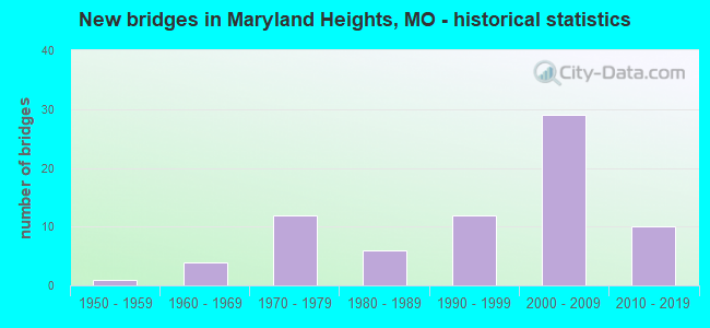
- New bridges - historical statistics
- 11950-1959
- 41960-1969
- 121970-1979
- 61980-1989
- 121990-1999
- 292000-2009
- 102010-2019

- Reconstructed bridges - Historical Statistics
- 11970-1979
- 21980-1989
- 01990-1999
- 12000-2009
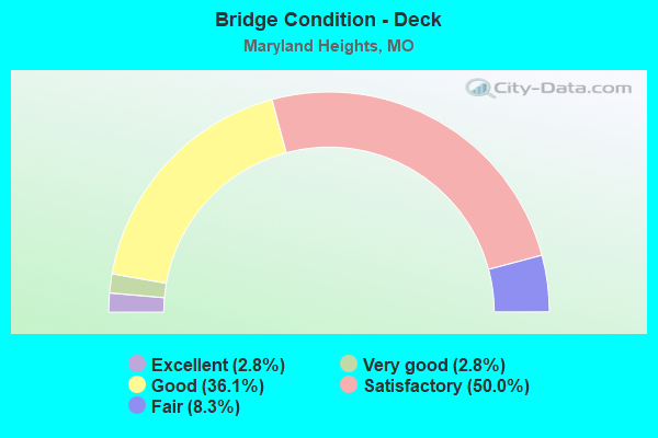
- Bridge Condition - Deck
- 2.8%Excellent
- 2.8%Very good
- 36.1%Good
- 50.0%Satisfactory
- 8.3%Fair
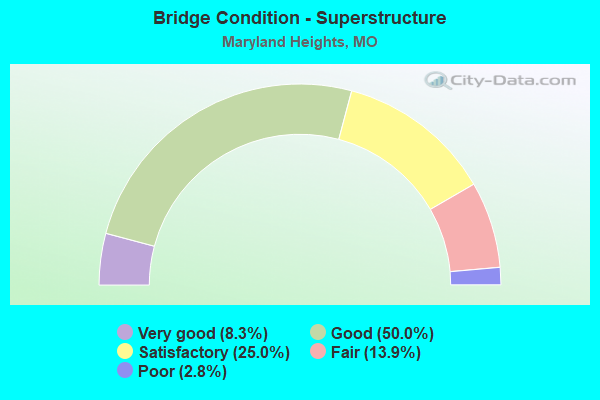
- Bridge Condition - Superstructure
- 8.3%Very good
- 50.0%Good
- 25.0%Satisfactory
- 13.9%Fair
- 2.8%Poor
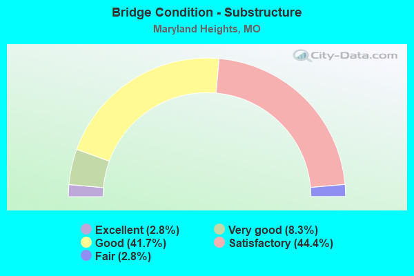
- Bridge Condition - Substructure
- 2.8%Excellent
- 8.3%Very good
- 41.7%Good
- 44.4%Satisfactory
- 2.8%Fair
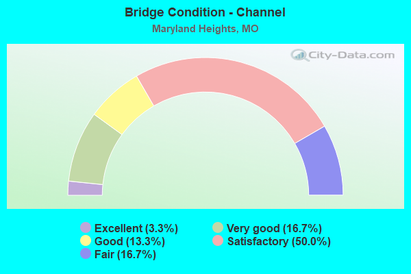
- Bridge Condition - Channel
- 3.3%Excellent
- 16.7%Very good
- 13.3%Good
- 50.0%Satisfactory
- 16.7%Fair
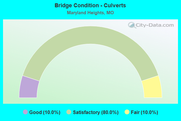
- Bridge Condition - Culverts
- 10.0%Good
- 80.0%Satisfactory
- 10.0%Fair
Find on map >> Show street view
Structure Number: 12063, Location: S 29 T 46 N R 5 E (Lat: 38.706114, Lng: -90.478436), Route carried "on" structure: County highway , Year Built: 1999, Status: Open, Structure Length: 6.19m (20.31ft), Average Daily Traffic: 4,486 (year 2021), Truck Traffic: 5%, Average Future Daily Traffic: 6,729 (year 2041), Design Load: HS 20, Features Intersected: MO 364, Facility Carried by Structure: SEVEN PINES DR S
Minimum Vertical Clearance: 30+ m (98+ ft), Kilometerpoint: 0.573, Lanes on structure: 2, Lanes under structure: 10, Owner: State Highway Agency, Approaching Roadway Width: 10.4m (34.1ft), Skew: 2 degrees, Material/Design: Steel continuous, Design/Construction: Stringer/Multi-beam, Number Of Spans In Main Unit: 2, Length of Maximum Span: 30.9m (101.4ft), Curb or Sidewalk Widths: Left: 0.0m, Right: 1.6m (5.2ft), Curb-To-Curb Width: 10.2m (33.5ft), Out-to-Out Width: 11.0m (36.1ft)
Condition: Deck: Satisfactory, Superstructure: Satisfactory, Substructure: Good, Operating Rating: 64.8 metric tons, Method Used To Determine Operating Rating: Load Factor (LF), Inventory Rating: 39.6 metric tons, Method Used To Determine Inventory Rating: Load Factor (LF), Structural Evaluation: Equal to present minimum criteria, Deck Geometry: Meets minimum limits, Underclear: Somewhat better than minimum adequacy, Approach Roadway Alignment: Better than present minimum criteria, Designated Inspection Frequency: Every 24 months, Inspection Date: September 2020, Deck Structure Type: Concrete Cast-file-Place, Wearing Surface/Protective System: Wearing Surface: Epoxy Overlay, Deck Protection: Epoxy Coated Reinforcing
Find on map >> Show street view
Structure Number: 12064, Location: S 29 T 46 N R 5 E (Lat: 38.705281, Lng: -90.475494), Route carried "on" structure: County highway , Year Built: 1999, Status: Open, Structure Length: 6.43m (21.10ft), Average Daily Traffic: 4,489 (year 2021), Truck Traffic: 3%, Average Future Daily Traffic: 6,734 (year 2041), Design Load: HS 20, Features Intersected: MO 364, Facility Carried by Structure: AMIOT DR E
Minimum Vertical Clearance: 30+ m (98+ ft), Kilometerpoint: 2.354, Lanes on structure: 2, Lanes under structure: 10, Owner: State Highway Agency, Approaching Roadway Width: 7.0m (23.0ft), Skew: 3 degrees, Material/Design: Prestressed concrete continuous, Design/Construction: Tee Beam, Number Of Spans In Main Unit: 2, Length of Maximum Span: 32.7m (107.3ft), Curb or Sidewalk Widths: Left: 1.7m (5.6ft), Right: 1.7m (5.6ft), Curb-To-Curb Width: 12.0m (39.4ft), Out-to-Out Width: 12.8m (42.0ft)
Condition: Deck: Satisfactory, Superstructure: Good, Substructure: Very good, Operating Rating: 97.2 metric tons, Method Used To Determine Operating Rating: Load Factor (LF), Inventory Rating: 57.6 metric tons, Method Used To Determine Inventory Rating: Load Factor (LF), Structural Evaluation: Better than present minimum criteria, Deck Geometry: Somewhat better than minimum adequacy, Underclear: Somewhat better than minimum adequacy, Approach Roadway Alignment: Equal to present desirable criteria, Designated Inspection Frequency: Every 24 months, Inspection Date: September 2020, Deck Structure Type: Concrete Cast-file-Place, Wearing Surface/Protective System: Wearing Surface: Epoxy Overlay, Deck Protection: Epoxy Coated Reinforcing
Find on map >> Show street view
Structure Number: 12108, Location: S 24 T 46 N R 4 E (Lat: 38.719053, Lng: -90.510444), Route carried "on" structure: City street , Year Built: 2001, Status: Open, Structure Length: 9.72m (31.89ft), Average Daily Traffic: 5,388 (year 2021), Truck Traffic: 5%, Average Future Daily Traffic: 8,082 (year 2041), Design Load: HS 20, Features Intersected: MO 364, Facility Carried by Structure: RIVER VALLEY DR S
Minimum Vertical Clearance: 30+ m (98+ ft), Kilometerpoint: 1.455, Lanes on structure: 2, Lanes under structure: 10, Owner: State Highway Agency, Approaching Roadway Width: 11.9m (39.0ft), Skew: 2 degrees, Material/Design: Steel continuous, Design/Construction: Stringer/Multi-beam, Number Of Spans In Main Unit: 2, Length of Maximum Span: 39.9m (130.9ft), Curb-To-Curb Width: 12.2m (40.0ft), Out-to-Out Width: 13.0m (42.7ft)
Condition: Deck: Good, Superstructure: Very good, Substructure: Good, Operating Rating: 59.4 metric tons, Method Used To Determine Operating Rating: Load Factor (LF), Inventory Rating: 36.0 metric tons, Method Used To Determine Inventory Rating: Load Factor (LF), Structural Evaluation: Better than present minimum criteria, Deck Geometry: Somewhat better than minimum adequacy, Underclear: Somewhat better than minimum adequacy, Approach Roadway Alignment: Better than present minimum criteria, Designated Inspection Frequency: Every 24 months, Inspection Date: September 2020, Deck Structure Type: Concrete Cast-file-Place, Wearing Surface/Protective System: Wearing Surface: Monolithic Concrete, Deck Protection: Epoxy Coated Reinforcing
Find on map >> Show street view
Structure Number: 12132, Location: S 1929 T 46 N R 5 E (Lat: 38.706183, Lng: -90.486111), Route carried "on" structure: State highway 364, Year Built: 1999, Status: Open, Structure Length: 81.93m (268.80ft), Average Daily Traffic: 73,292 (year 2021), Truck Traffic: 5%, Average Future Daily Traffic: 91,615 (year 2041), Design Load: HS 25 or greater, Features Intersected: CREVE COEUR LK
Minimum Vertical Clearance: 30+ m (98+ ft), Kilometerpoint: 29.857, Lanes on structure: 10, Base Highway Network: Yes, Owner: State Highway Agency, Approaching Roadway Width: 52.5m (172.2ft), Skew: 30 degrees, Material/Design: Prestressed concrete continuous, Design/Construction: Segmental Box Girder, Number Of Spans In Main Unit: 9, Length of Maximum Span: 143.0m (469.2ft), Curb-To-Curb Width: 50.7m (166.3ft), Out-to-Out Width: 52.5m (172.2ft)
Condition: Deck: Good, Superstructure: Good, Substructure: Good, Channel: Very good, Inventory Rating: 51.3 metric tons, Method Used To Determine Inventory Rating: Load Factor (LF), Structural Evaluation: Better than present minimum criteria, Deck Geometry: Superior to present desirable criteria, Waterway Adequacy: Superior to present desirable criteria, Approach Roadway Alignment: Equal to present desirable criteria, Designated Inspection Frequency: Every 24 months, Inspection Date: July 2020, Deck Structure Type: Concrete Cast-file-Place, Wearing Surface/Protective System: Wearing Surface: Other, Deck Protection: Epoxy Coated Reinforcing
Find on map >> Show street view
Structure Number: 12136, Location: S 3094 T 46 N R 5 E (Lat: 38.706364, Lng: -90.496281), Route carried "on" structure: State highway 364, Year Built: 2001, Status: Open, Structure Length: 9.42m (30.91ft), Average Daily Traffic: 38,396 (year 2021), Truck Traffic: 5%, Average Future Daily Traffic: 47,995 (year 2041), Design Load: HS 20+Mod, Features Intersected: CST CREVE COEUR MILL RD,
Minimum Vertical Clearance: 30+ m (98+ ft), Kilometerpoint: 29.338, Lanes on structure: 6, Lanes under structure: 2, Base Highway Network: Yes, Owner: State Highway Agency, Approaching Roadway Width: 29.0m (95.1ft), Material/Design: Steel continuous, Design/Construction: Stringer/Multi-beam, Number Of Spans In Main Unit: 3, Length of Maximum Span: 43.5m (142.7ft), Curb or Sidewalk Widths: Left: 0.0m, Right: 3.6m (11.8ft), Curb-To-Curb Width: 28.7m (94.2ft), Out-to-Out Width: 32.9m (107.9ft)
Condition: Deck: Good, Superstructure: Good, Substructure: Good, Operating Rating: 85.5 metric tons, Method Used To Determine Operating Rating: Load Factor (LF), Inventory Rating: 51.3 metric tons, Method Used To Determine Inventory Rating: Load Factor (LF), Structural Evaluation: Better than present minimum criteria, Deck Geometry: Superior to present desirable criteria, Underclear: Equal to present desirable criteria, Approach Roadway Alignment: Equal to present desirable criteria, Designated Inspection Frequency: Every 24 months, Inspection Date: September 2020, Deck Structure Type: Concrete Cast-file-Place, Wearing Surface/Protective System: Wearing Surface: Monolithic Concrete, Deck Protection: Epoxy Coated Reinforcing
Find on map >> Show street view
Structure Number: 12138, Location: S 3094 T 46 N R 5 E (Lat: 38.706586, Lng: -90.496239), Route carried "on" structure: State highway 364, Year Built: 2001, Status: Open, Structure Length: 9.42m (30.91ft), Average Daily Traffic: 34,896 (year 2021), Truck Traffic: 13%, Average Future Daily Traffic: 43,620 (year 2041), Design Load: HS 20+Mod, Features Intersected: CST CREVE COEUR MILL RD,
Minimum Vertical Clearance: 30+ m (98+ ft), Kilometerpoint: 4.978, Lanes on structure: 5, Lanes under structure: 2, Base Highway Network: Yes, Owner: State Highway Agency, Approaching Roadway Width: 25.6m (84.0ft), Material/Design: Steel continuous, Design/Construction: Stringer/Multi-beam, Number Of Spans In Main Unit: 3, Length of Maximum Span: 43.5m (142.7ft), Curb-To-Curb Width: 25.1m (82.3ft), Out-to-Out Width: 25.9m (85.0ft)
Condition: Deck: Satisfactory, Superstructure: Satisfactory, Substructure: Good, Operating Rating: 87.3 metric tons, Method Used To Determine Operating Rating: Load Factor (LF), Inventory Rating: 52.2 metric tons, Method Used To Determine Inventory Rating: Load Factor (LF), Structural Evaluation: Equal to present minimum criteria, Deck Geometry: Better than present minimum criteria, Underclear: Equal to present desirable criteria, Approach Roadway Alignment: Equal to present desirable criteria, Designated Inspection Frequency: Every 24 months, Inspection Date: September 2020, Deck Structure Type: Concrete Cast-file-Place, Wearing Surface/Protective System: Wearing Surface: Monolithic Concrete, Deck Protection: Epoxy Coated Reinforcing
Find on map >> Show street view
Structure Number: 12141, Location: S 19 T 46 N R 5 E (Lat: 38.707403, Lng: -90.502047), Route carried "on" structure: State highway 364, Year Built: 2001, Status: Open, Structure Length: 9.20m (30.18ft), Average Daily Traffic: 36,942 (year 2021), Truck Traffic: 5%, Average Future Daily Traffic: 46,178 (year 2041), Design Load: HS 20+Mod, Features Intersected: MO 141, RP MO364E TO M
Minimum Vertical Clearance: 30+ m (98+ ft), Kilometerpoint: 28.807, Lanes on structure: 4, Lanes under structure: 9, Base Highway Network: Yes, Owner: State Highway Agency, Approaching Roadway Width: 21.9m (71.9ft), Skew: 2 degrees, Material/Design: Prestressed concrete continuous, Design/Construction: Stringer/Multi-beam, Number Of Spans In Main Unit: 4, Length of Maximum Span: 23.4m (76.8ft), Curb-To-Curb Width: 21.4m (70.2ft), Out-to-Out Width: 22.3m (73.2ft)
Condition: Deck: Good, Superstructure: Good, Substructure: Good, Operating Rating: 87.3 metric tons, Method Used To Determine Operating Rating: Load Factor (LF), Inventory Rating: 52.2 metric tons, Method Used To Determine Inventory Rating: Load Factor (LF), Structural Evaluation: Better than present minimum criteria, Deck Geometry: Superior to present desirable criteria, Underclear: Equal to present minimum criteria, Approach Roadway Alignment: Equal to present desirable criteria, Designated Inspection Frequency: Every 24 months, Inspection Date: September 2020, Deck Structure Type: Concrete Cast-file-Place, Wearing Surface/Protective System: Wearing Surface: Monolithic Concrete, Deck Protection: Epoxy Coated Reinforcing
Find on map >> Show street view
Structure Number: 12143, Location: S 19 T 46 N R 5 E (Lat: 38.707603, Lng: -90.502008), Route carried "on" structure: State highway 364, Year Built: 2001, Status: Open, Structure Length: 9.24m (30.31ft), Average Daily Traffic: 34,896 (year 2021), Truck Traffic: 13%, Average Future Daily Traffic: 43,620 (year 2041), Design Load: HS 20+Mod, Features Intersected: MO 141, RP MO364E TO M
Minimum Vertical Clearance: 30+ m (98+ ft), Kilometerpoint: 5.496, Lanes on structure: 5, Lanes under structure: 9, Base Highway Network: Yes, Owner: State Highway Agency, Approaching Roadway Width: 25.6m (84.0ft), Skew: 2 degrees, Material/Design: Prestressed concrete continuous, Design/Construction: Stringer/Multi-beam, Number Of Spans In Main Unit: 4, Length of Maximum Span: 23.5m (77.1ft), Curb-To-Curb Width: 24.4m (80.1ft), Out-to-Out Width: 25.3m (83.0ft)
Condition: Deck: Good, Superstructure: Good, Substructure: Good, Operating Rating: 93.6 metric tons, Method Used To Determine Operating Rating: Load Factor (LF), Inventory Rating: 55.8 metric tons, Method Used To Determine Inventory Rating: Load Factor (LF), Structural Evaluation: Better than present minimum criteria, Deck Geometry: Superior to present desirable criteria, Underclear: Equal to present minimum criteria, Approach Roadway Alignment: Equal to present desirable criteria, Designated Inspection Frequency: Every 24 months, Inspection Date: September 2020, Deck Structure Type: Concrete Cast-file-Place, Wearing Surface/Protective System: Wearing Surface: Monolithic Concrete, Deck Protection: Epoxy Coated Reinforcing
Find on map >> Show street view
Structure Number: 1233, Location: S 1312 T 46 N R 5 E (Lat: 38.703922, Lng: -90.449883), Route carried "on" structure: Interstate 270, Year Built: 1965, Year Reconstructed: 1984, Status: Open, Structure Length: 4.66m (15.29ft), Average Daily Traffic: 133,939 (year 2021), Truck Traffic: 12%, Average Future Daily Traffic: 167,424 (year 2041), Design Load: HS 20+Mod, Features Intersected: CST WEST PORT PLAZA DR
Minimum Vertical Clearance: 30+ m (98+ ft), Kilometerpoint: 27.657, Lanes on structure: 10, Lanes under structure: 4, Base Highway Network: Yes, Owner: State Highway Agency, Approaching Roadway Width: 39.0m (128.0ft), Skew: 1 degrees, Material/Design: Concrete continuous, Design/Construction: Slab, Number Of Spans In Main Unit: 3, Length of Maximum Span: 18.9m (62.0ft), Curb-To-Curb Width: 45.3m (148.6ft), Out-to-Out Width: 46.8m (153.5ft)
Condition: Deck: Fair, Superstructure: Poor, Substructure: Satisfactory, Operating Rating: 62.1 metric tons, Method Used To Determine Operating Rating: Load Factor (LF), Inventory Rating: 36.9 metric tons, Method Used To Determine Inventory Rating: Load Factor (LF), Structural Evaluation: Meets minimum limits, Deck Geometry: Superior to present desirable criteria, Underclear: Meets minimum limits, Approach Roadway Alignment: Equal to present desirable criteria, Length Of Structure Improvement: 0.57m (1.87ft), Designated Inspection Frequency: Every 24 months, Inspection Date: August 2020, Bridge Improvement Cost: $1,633,000, Roadway Improvement Cost: $163,000, Total Project Cost: $2,449,000 ( Estimate for 2022), Deck Structure Type: Concrete Cast-file-Place, Wearing Surface/Protective System: Wearing Surface: Other, Deck Protection: Cathodic Protection
Find on map >> Show street view
Structure Number: 15567, Location: S 31 T 46 N R 5 E (Lat: 38.692858, Lng: -90.497667), Route carried "on" structure: County highway , Year Built: 1971, Status: Posted for load, Structure Length: 4.02m (13.19ft), Average Daily Traffic: 2,292 (year 2020), Truck Traffic: 5%, Average Future Daily Traffic: 3,094 (year 2040), Design Load: HS 20, Features Intersected: BR CREVE COEUR CR, Facility Carried by Structure: CREVE COEUR MILL
Minimum Vertical Clearance: 30+ m (98+ ft), Kilometerpoint: 1.448, Lanes on structure: 2, Owner: County Highway Agency, Approaching Roadway Width: 7.0m (23.0ft), Material/Design: Steel continuous, Design/Construction: Stringer/Multi-beam, Number Of Spans In Main Unit: 3, Length of Maximum Span: 15.2m (49.9ft), Curb or Sidewalk Widths: Left: 0.8m (2.6ft), Right: 0.0m, Curb-To-Curb Width: 7.3m (24.0ft), Out-to-Out Width: 8.4m (27.6ft)
Condition: Deck: Satisfactory, Superstructure: Satisfactory, Substructure: Satisfactory, Channel: Satisfactory, Operating Rating: 63.0 metric tons, Method Used To Determine Operating Rating: Allowable Stress (AS), Inventory Rating: 22.5 metric tons, Method Used To Determine Inventory Rating: Allowable Stress (AS), Structural Evaluation: Equal to present minimum criteria, Deck Geometry: High priority of replacement, Waterway Adequacy: Equal to present desirable criteria, Approach Roadway Alignment: Better than present minimum criteria, Length Of Structure Improvement: 0.50m (1.64ft), Designated Inspection Frequency: Every 24 months, Inspection Date: April 2021, Bridge Improvement Cost: $428,000, Roadway Improvement Cost: $43,000, Total Project Cost: $642,000 ( Estimate for 2022), Deck Structure Type: Concrete Cast-file-Place, Wearing Surface/Protective System: Wearing Surface: Monolithic Concrete, Membrane: Epoxy
Find on map >> Show street view
Structure Number: 15575, Location: S 22 T 46 N R 5 E (Lat: 38.714553, Lng: -90.437756), Route carried "on" structure: County highway , Year Built: 1980, Status: Posted for load, Structure Length: 2.99m (9.81ft), Average Daily Traffic: 31,959 (year 2020), Truck Traffic: 10%, Average Future Daily Traffic: 43,145 (year 2040), Design Load: HS 20+Mod, Features Intersected: FEE FEE CR, Facility Carried by Structure: DORSETT RD
Minimum Vertical Clearance: 30+ m (98+ ft), Kilometerpoint: 0.000, Lanes on structure: 4, Owner: County Highway Agency, Approaching Roadway Width: 16.2m (53.1ft), Material/Design: Prestressed concrete, Design/Construction: Stringer/Multi-beam, Number Of Spans In Main Unit: 2, Length of Maximum Span: 14.3m (46.9ft), Curb or Sidewalk Widths: Left: 1.6m (5.2ft), Right: 1.6m (5.2ft), Curb-To-Curb Width: 16.2m (53.1ft), Out-to-Out Width: 17.4m (57.1ft)
Condition: Deck: Satisfactory, Superstructure: Good, Substructure: Good, Channel: Satisfactory, Operating Rating: 67.5 metric tons, Method Used To Determine Operating Rating: Allowable Stress (AS), Inventory Rating: 39.6 metric tons, Method Used To Determine Inventory Rating: Allowable Stress (AS), Structural Evaluation: Better than present minimum criteria, Deck Geometry: Meets minimum limits, Waterway Adequacy: Superior to present desirable criteria, Approach Roadway Alignment: Equal to present desirable criteria, Designated Inspection Frequency: Every 24 months, Inspection Date: April 2021, Deck Structure Type: Concrete Cast-file-Place, Wearing Surface/Protective System: Wearing Surface: Monolithic Concrete, Membrane: Epoxy, Deck Protection: Epoxy Coated Reinforcing
Find on map >> Show street view
Structure Number: 15577, Location: S 17 T 46 N R 5 E (Lat: 38.727450, Lng: -90.448033), Route carried "on" structure: County highway , Year Built: 1982, Status: Posted for load, Structure Length: 10.85m (35.60ft), Average Daily Traffic: 8,730 (year 2020), Truck Traffic: 5%, Average Future Daily Traffic: 11,786 (year 2040), Design Load: HS 20, Features Intersected: BNSF RR, FEE FEE CR, Facility Carried by Structure: MCKELVEY RD
Minimum Vertical Clearance: 30+ m (98+ ft), Kilometerpoint: 0.000, Lanes on structure: 2, Owner: County Highway Agency, Approaching Roadway Width: 13.4m (44.0ft), Material/Design: Steel continuous, Design/Construction: Stringer/Multi-beam, Number Of Spans In Main Unit: 4, Length of Maximum Span: 36.6m (120.1ft), Curb-To-Curb Width: 13.4m (44.0ft), Out-to-Out Width: 18.1m (59.4ft)
Condition: Deck: Satisfactory, Superstructure: Satisfactory, Substructure: Satisfactory, Channel: Satisfactory, Operating Rating: 61.2 metric tons, Method Used To Determine Operating Rating: Allowable Stress (AS), Inventory Rating: 35.1 metric tons, Method Used To Determine Inventory Rating: Allowable Stress (AS), Structural Evaluation: Equal to present minimum criteria, Deck Geometry: Equal to present minimum criteria, Underclear: Equal to present desirable criteria, Waterway Adequacy: Superior to present desirable criteria, Approach Roadway Alignment: Better than present minimum criteria, Designated Inspection Frequency: Every 24 months, Inspection Date: April 2020, Deck Structure Type: Concrete Cast-file-Place, Wearing Surface/Protective System: Wearing Surface: Monolithic Concrete, Membrane: Epoxy, Deck Protection: Epoxy Coated Reinforcing
Find on map >> Show street view
Structure Number: 15578, Location: S 16 T 46 N R 5 E (Lat: 38.736231, Lng: -90.464458), Route carried "on" structure: County highway , Year Built: 1957, Year Reconstructed: 1988, Status: Posted for load, Structure Length: 3.99m (13.09ft), Average Daily Traffic: 5,594 (year 2020), Truck Traffic: 20%, Average Future Daily Traffic: 7,552 (year 2040), Design Load: HS 20, Features Intersected: FEE FEE CR, Facility Carried by Structure: CREVE COEUR MILL
Minimum Vertical Clearance: 30+ m (98+ ft), Kilometerpoint: 0.322, Lanes on structure: 4, Owner: County Highway Agency, Approaching Roadway Width: 15.2m (49.9ft), Material/Design: Prestressed concrete continuous, Design/Construction: Stringer/Multi-beam, Number Of Spans In Main Unit: 3, Length of Maximum Span: 14.6m (47.9ft), Curb-To-Curb Width: 15.8m (51.8ft), Out-to-Out Width: 18.7m (61.4ft)
Condition: Deck: Satisfactory, Superstructure: Fair, Substructure: Satisfactory, Channel: Satisfactory, Operating Rating: 56.7 metric tons, Method Used To Determine Operating Rating: Allowable Stress (AS), Inventory Rating: 41.4 metric tons, Method Used To Determine Inventory Rating: Allowable Stress (AS), Structural Evaluation: Somewhat better than minimum adequacy, Deck Geometry: Meets minimum limits, Waterway Adequacy: Equal to present minimum criteria, Approach Roadway Alignment: Better than present minimum criteria, Designated Inspection Frequency: Every 24 months, Inspection Date: March 2020, Deck Structure Type: Concrete Cast-file-Place, Wearing Surface/Protective System: Wearing Surface: Monolithic Concrete, Deck Protection: Epoxy Coated Reinforcing
Find on map >> Show street view
Structure Number: 15673, Location: S 32 T 46 N R 5 E (Lat: 38.692111, Lng: -90.487900), Route carried "on" structure: County highway , Year Built: 1966, Status: Posted for load, Structure Length: 1.04m (3.41ft), Average Daily Traffic: 3,161 (year 2020), Truck Traffic: 2%, Average Future Daily Traffic: 4,267 (year 2040), Design Load: H 10, Features Intersected: TRIB CREVE COEUR C, Facility Carried by Structure: BOOKBINDER DR
Minimum Vertical Clearance: 30+ m (98+ ft), Kilometerpoint: 0.016, Lanes on structure: 2, Owner: County Highway Agency, Approaching Roadway Width: 7.9m (25.9ft), Material/Design: Concrete continuous, Design/Construction: Culvert, Number Of Spans In Main Unit: 2, Length of Maximum Span: 4.0m (13.1ft), Curb-To-Curb Width: 7.8m (25.6ft), Out-to-Out Width: 10.7m (35.1ft)
Condition: Channel: Fair, Culverts: Fair, Operating Rating: 35.1 metric tons, Method Used To Determine Operating Rating: Allowable Stress (AS), Inventory Rating: 22.5 metric tons, Method Used To Determine Inventory Rating: Allowable Stress (AS), Structural Evaluation: Somewhat better than minimum adequacy, Deck Geometry: High priority of replacement, Waterway Adequacy: Better than present minimum criteria, Approach Roadway Alignment: Equal to present minimum criteria, Length Of Structure Improvement: 0.17m (0.56ft), Designated Inspection Frequency: Every 24 months, Inspection Date: April 2021, Bridge Improvement Cost: $85,000, Roadway Improvement Cost: $9,000, Total Project Cost: $128,000 ( Estimate for 2022)
Find on map >> Show street view
Structure Number: 15676, Location: S 25 T 46 N R 5 E (Lat: 38.703556, Lng: -90.407083), Route carried "on" structure: County highway , Year Built: 1986, Status: Posted for load, Structure Length: 0.82m (2.69ft), Average Daily Traffic: 3,808 (year 2020), Truck Traffic: 5%, Average Future Daily Traffic: 5,141 (year 2040), Design Load: HS 20, Features Intersected: MIDLAND CR, Facility Carried by Structure: LINK AVE
Minimum Vertical Clearance: 30+ m (98+ ft), Kilometerpoint: 2.897, Lanes on structure: 2, Owner: County Highway Agency, Approaching Roadway Width: 8.5m (27.9ft), Material/Design: Concrete, Design/Construction: Culvert, Number Of Spans In Main Unit: 2, Length of Maximum Span: 3.7m (12.1ft)
Condition: Channel: Fair, Culverts: Satisfactory, Operating Rating: 63.0 metric tons, Method Used To Determine Operating Rating: Allowable Stress (AS), Inventory Rating: 22.5 metric tons, Method Used To Determine Inventory Rating: Allowable Stress (AS), Structural Evaluation: Equal to present minimum criteria, Waterway Adequacy: Equal to present desirable criteria, Approach Roadway Alignment: Equal to present desirable criteria, Designated Inspection Frequency: Every 24 months, Inspection Date: April 2021
Find on map >> Show street view
Structure Number: 15681, Location: S 35 T 46 N R 5 E (Lat: 38.683925, Lng: -90.420386), Route carried "on" structure: County highway , Year Built: 1978, Status: Posted for load, Structure Length: 0.82m (2.69ft), Average Daily Traffic: 623 (year 2020), Truck Traffic: 2%, Average Future Daily Traffic: 841 (year 2040), Design Load: HS 20, Features Intersected: E TRIB OF FEE FEE, Facility Carried by Structure: CRESTED VIEW DR
Minimum Vertical Clearance: 30+ m (98+ ft), Kilometerpoint: 12.553, Lanes on structure: 2, Owner: County Highway Agency, Approaching Roadway Width: 7.9m (25.9ft), Material/Design: Concrete, Design/Construction: Culvert, Number Of Spans In Main Unit: 3, Length of Maximum Span: 2.4m (7.9ft)
Condition: Channel: Satisfactory, Culverts: Satisfactory, Operating Rating: 35.1 metric tons, Method Used To Determine Operating Rating: Allowable Stress (AS), Inventory Rating: 22.5 metric tons, Method Used To Determine Inventory Rating: Allowable Stress (AS), Structural Evaluation: Equal to present minimum criteria, Waterway Adequacy: Superior to present desirable criteria, Approach Roadway Alignment: Equal to present desirable criteria, Designated Inspection Frequency: Every 24 months, Inspection Date: April 2020
Find on map >> Show street view
Structure Number: 2069, Location: S 22 T 41 N R 21 W (Lat: 38.318586, Lng: -93.233431), Route carried "on" structure: State highway H, Year Built: 1968, Year Reconstructed: 2021, Status: Open, Structure Length: 10.64m (34.91ft), Average Daily Traffic: 1,225 (year 2021), Truck Traffic: 9%, Average Future Daily Traffic: 1,960 (year 2041), Design Load: H 15, Features Intersected: COLE CAMP CR
Minimum Vertical Clearance: 30+ m (98+ ft), Kilometerpoint: 12.967, Lanes on structure: 2, Owner: State Highway Agency, Approaching Roadway Width: 6.1m (20.0ft), Skew: 2 degrees, Material/Design: Steel continuous, Design/Construction: Stringer/Multi-beam, Number Of Spans In Main Unit: 4, Number Of Approach Spans: 1, Length of Maximum Span: 26.2m (86.0ft), Curb-To-Curb Width: 8.5m (27.9ft), Out-to-Out Width: 9.3m (30.5ft)
Condition: Deck: Excellent, Superstructure: Good, Substructure: Satisfactory, Channel: Satisfactory, Operating Rating: 31.5 metric tons, Method Used To Determine Operating Rating: Load Factor (LF), Inventory Rating: 18.9 metric tons, Method Used To Determine Inventory Rating: Load Factor (LF), Structural Evaluation: Somewhat better than minimum adequacy, Deck Geometry: Somewhat better than minimum adequacy, Waterway Adequacy: Equal to present desirable criteria, Approach Roadway Alignment: Equal to present desirable criteria, Designated Inspection Frequency: Every 24 months, Inspection Date: January 2022, Deck Structure Type: Concrete Cast-file-Place, Wearing Surface/Protective System: Wearing Surface: Monolithic Concrete, Deck Protection: Epoxy Coated Reinforcing
Find on map >> Show street view
Structure Number: 2069, Location: S 27 T 46 N R 5 E (Lat: 38.695903, Lng: -90.432297), Route carried "on" structure: City street , Year Built: 1980, Status: Posted for load, Structure Length: 0.85m (2.79ft), Average Daily Traffic: 4,000 (year 2020), Truck Traffic: 1%, Average Future Daily Traffic: 5,400 (year 2040), Design Load: HS 20, Features Intersected: BR OF FEE FEE CR, Facility Carried by Structure: BORMAN DR
Minimum Vertical Clearance: 30+ m (98+ ft), Kilometerpoint: 12.231, Lanes on structure: 2, Owner: City or Municipal Highway Agency, Approaching Roadway Width: 7.6m (24.9ft), Material/Design: Concrete, Design/Construction: Culvert, Number Of Spans In Main Unit: 2, Length of Maximum Span: 3.7m (12.1ft)
Condition: Channel: Satisfactory, Culverts: Satisfactory, Operating Rating: 35.1 metric tons, Method Used To Determine Operating Rating: Load Factor (LF), Inventory Rating: 22.5 metric tons, Method Used To Determine Inventory Rating: Load Factor (LF), Structural Evaluation: Equal to present minimum criteria, Waterway Adequacy: Equal to present desirable criteria, Approach Roadway Alignment: Equal to present desirable criteria, Designated Inspection Frequency: Every 24 months, Inspection Date: December 2021
Find on map >> Show street view
Structure Number: 20693, Location: S 22 T 46 N R 5 E (Lat: 38.710597, Lng: -90.435722), Route carried "on" structure: City street , Year Built: 1970, Status: Posted for load, Structure Length: 3.69m (12.11ft), Average Daily Traffic: 11,800 (year 2020), Truck Traffic: 8%, Average Future Daily Traffic: 15,930 (year 2040), Design Load: HS 20, Features Intersected: FEE FEE CR, Facility Carried by Structure: FEE FEE RD
Minimum Vertical Clearance: 30+ m (98+ ft), Kilometerpoint: 0.483, Lanes on structure: 2, Owner: City or Municipal Highway Agency, Approaching Roadway Width: 11.9m (39.0ft), Material/Design: Concrete continuous, Design/Construction: Slab, Number Of Spans In Main Unit: 1, Number Of Approach Spans: 2, Length of Maximum Span: 15.5m (50.9ft), Curb or Sidewalk Widths: Left: 1.5m (4.9ft), Right: 1.5m (4.9ft), Curb-To-Curb Width: 13.4m (44.0ft), Out-to-Out Width: 17.1m (56.1ft)
Condition: Deck: Fair, Superstructure: Fair, Substructure: Good, Channel: Satisfactory, Operating Rating: 81.0 metric tons, Method Used To Determine Operating Rating: Load and Resistance Factor (LRFR), Inventory Rating: 48.6 metric tons, Method Used To Determine Inventory Rating: Load and Resistance Factor (LRFR), Structural Evaluation: Somewhat better than minimum adequacy, Deck Geometry: Equal to present minimum criteria, Waterway Adequacy: Better than present minimum criteria, Approach Roadway Alignment: Equal to present desirable criteria, Designated Inspection Frequency: Every 24 months, Inspection Date: December 2021, Deck Structure Type: Concrete Cast-file-Place, Wearing Surface/Protective System: Wearing Surface: Other
Find on map >> Show street view
Structure Number: 20695, Location: S 14 T 46 N R 5 E (Lat: 38.724072, Lng: -90.427386), Route carried "on" structure: City street , Year Built: 1999, Status: Open, Structure Length: 2.32m (7.61ft), Average Daily Traffic: 2,500 (year 2020), Truck Traffic: 1%, Average Future Daily Traffic: 3,375 (year 2040), Design Load: HS 20, Features Intersected: TRIB TO FEE FEE CR, Facility Carried by Structure: SMILEY RD
Minimum Vertical Clearance: 30+ m (98+ ft), Kilometerpoint: 0.805, Lanes on structure: 2, Owner: City or Municipal Highway Agency, Approaching Roadway Width: 7.9m (25.9ft), Material/Design: Prestressed concrete, Design/Construction: Box Beam or Girders - Multiple, Number Of Spans In Main Unit: 3, Length of Maximum Span: 21.6m (70.9ft), Curb or Sidewalk Widths: Left: 1.6m (5.2ft), Right: 0.0m, Curb-To-Curb Width: 8.2m (26.9ft), Out-to-Out Width: 11.0m (36.1ft)
Condition: Deck: Fair, Superstructure: Fair, Substructure: Satisfactory, Channel: Satisfactory, Operating Rating: 56.7 metric tons, Method Used To Determine Operating Rating: Load Factor (LF), Inventory Rating: 34.2 metric tons, Method Used To Determine Inventory Rating: Load Factor (LF), Structural Evaluation: Somewhat better than minimum adequacy, Deck Geometry: High priority of corrective action, Waterway Adequacy: Better than present minimum criteria, Approach Roadway Alignment: Equal to present desirable criteria, Length Of Structure Improvement: 0.32m (1.05ft), Designated Inspection Frequency: Every 24 months, Inspection Date: December 2021, Bridge Improvement Cost: $274,000, Roadway Improvement Cost: $27,000, Total Project Cost: $411,000 ( Estimate for 2022), Deck Structure Type: Concrete Precast Panels, Wearing Surface/Protective System: Wearing Surface: Bituminous
Find on map >> Show street view
Structure Number: 2732, Location: S 4 T 46 N R 5 E (Lat: 38.755567, Lng: -90.458628), Route carried "on" structure: Interstate 70, Year Built: 1971, Year Reconstructed: 1987, Status: Open, Structure Length: 5.33m (17.49ft), Average Daily Traffic: 152,838 (year 2021), Truck Traffic: 12%, Average Future Daily Traffic: 191,048 (year 2041), Design Load: HS 20+Mod, Features Intersected: MO 141
Minimum Vertical Clearance: 30+ m (98+ ft), Kilometerpoint: 372.734, Lanes on structure: 12, Lanes under structure: 6, Base Highway Network: Yes, Owner: State Highway Agency, Approaching Roadway Width: 54.3m (178.1ft), Skew: 20 degrees, Material/Design: Steel, Design/Construction: Stringer/Multi-beam, Number Of Spans In Main Unit: 4, Length of Maximum Span: 16.8m (55.1ft), Curb or Sidewalk Widths: Left: 0.2m (0.7ft), Right: 0.2m (0.7ft), Curb-To-Curb Width: 53.6m (175.9ft), Out-to-Out Width: 54.1m (177.5ft)
Condition: Deck: Satisfactory, Superstructure: Fair, Substructure: Satisfactory, Operating Rating: 39.6 metric tons, Method Used To Determine Operating Rating: Load Factor (LF), Inventory Rating: 23.4 metric tons, Method Used To Determine Inventory Rating: Load Factor (LF), Structural Evaluation: Somewhat better than minimum adequacy, Deck Geometry: Superior to present desirable criteria, Underclear: High priority of corrective action, Approach Roadway Alignment: Equal to present desirable criteria, Length Of Structure Improvement: 0.64m (2.10ft), Designated Inspection Frequency: Every 24 months, Inspection Date: September 2020, Bridge Improvement Cost: $2,279,000, Roadway Improvement Cost: $228,000, Total Project Cost: $3,419,000 ( Estimate for 2022), Deck Structure Type: Concrete Cast-file-Place, Wearing Surface/Protective System: Wearing Surface: Bituminous, Membrane: Other
Find on map >> Show street view
Structure Number: 2823, Location: S 6 T 51 N R 34 W (Lat: 39.254314, Lng: -94.755081), Route carried "on" structure: Interstate 435, Year Built: 1983, Status: Open, Structure Length: 4.60m (15.09ft), Average Daily Traffic: 10,809 (year 2021), Truck Traffic: 12%, Average Future Daily Traffic: 22,158 (year 2041), Design Load: HS 20+Mod, Features Intersected: CRD NW TIFFANY PARK RD
Minimum Vertical Clearance: 30+ m (98+ ft), Kilometerpoint: 81.822, Lanes on structure: 2, Lanes under structure: 2, Base Highway Network: Yes, Owner: State Highway Agency, Approaching Roadway Width: 12.2m (40.0ft), Skew: 10 degrees, Material/Design: Prestressed concrete continuous, Design/Construction: Stringer/Multi-beam, Number Of Spans In Main Unit: 3, Length of Maximum Span: 16.8m (55.1ft), Curb or Sidewalk Widths: Left: 0.2m (0.7ft), Right: 0.2m (0.7ft), Curb-To-Curb Width: 11.8m (38.7ft), Out-to-Out Width: 12.6m (41.3ft)
Condition: Deck: Good, Superstructure: Good, Substructure: Satisfactory, Operating Rating: 78.3 metric tons, Method Used To Determine Operating Rating: Load Factor (LF), Inventory Rating: 46.8 metric tons, Method Used To Determine Inventory Rating: Load Factor (LF), Structural Evaluation: Equal to present minimum criteria, Deck Geometry: Equal to present minimum criteria, Underclear: Equal to present desirable criteria, Approach Roadway Alignment: Equal to present desirable criteria, Designated Inspection Frequency: Every 24 months, Inspection Date: October 2020, Deck Structure Type: Concrete Cast-file-Place, Wearing Surface/Protective System: Wearing Surface: Monolithic Concrete, Deck Protection: Epoxy Coated Reinforcing
Find on map >> Show street view
Structure Number: 2823, Location: S 23 T 46 N R 5 E (Lat: 38.721092, Lng: -90.422022), Route carried "on" structure: City street , Year Built: 2000, Year Reconstructed: 2007, Status: Open, Structure Length: 1.71m (5.61ft), Average Daily Traffic: 8,394 (year 2020), Truck Traffic: 1%, Average Future Daily Traffic: 11,332 (year 2040), Design Load: HS 20, Features Intersected: TRIB TO FEE FEE CR, Facility Carried by Structure: FEE FEE RD
Minimum Vertical Clearance: 30+ m (98+ ft), Kilometerpoint: 0.161, Lanes on structure: 3, Owner: City or Municipal Highway Agency, Approaching Roadway Width: 7.9m (25.9ft), Material/Design: Prestressed concrete, Design/Construction: Stringer/Multi-beam, Number Of Spans In Main Unit: 1, Length of Maximum Span: 16.5m (54.1ft), Curb or Sidewalk Widths: Left: 0.4m (1.3ft), Right: 0.4m (1.3ft), Curb-To-Curb Width: 11.6m (38.1ft), Out-to-Out Width: 16.1m (52.8ft)
Condition: Deck: Good, Superstructure: Good, Substructure: Good, Channel: Good, Operating Rating: 74.7 metric tons, Method Used To Determine Operating Rating: Load Factor (LF), Inventory Rating: 45.0 metric tons, Method Used To Determine Inventory Rating: Load Factor (LF), Structural Evaluation: Better than present minimum criteria, Deck Geometry: High priority of replacement, Waterway Adequacy: Better than present minimum criteria, Approach Roadway Alignment: Equal to present desirable criteria, Length Of Structure Improvement: 0.24m (0.79ft), Designated Inspection Frequency: Every 24 months, Inspection Date: December 2021, Bridge Improvement Cost: $264,000, Roadway Improvement Cost: $26,000, Total Project Cost: $396,000 ( Estimate for 2022), Deck Structure Type: Concrete Cast-file-Place, Wearing Surface/Protective System: Deck Protection: Epoxy Coated Reinforcing
Find on map >> Show street view
Structure Number: 28258, Location: S 35 T 46 N R 5 E (Lat: 38.685958, Lng: -90.420914), Route carried "on" structure: County highway , Year Built: 1997, Status: Posted for load, Structure Length: 0.70m (2.30ft), Average Daily Traffic: 8,070 (year 2020), Truck Traffic: 5%, Average Future Daily Traffic: 10,895 (year 2040), Design Load: HS 20, Features Intersected: TRIB OF FEE FEE CR, Facility Carried by Structure: SCHUETZ RD
Minimum Vertical Clearance: 30+ m (98+ ft), Kilometerpoint: 0.000, Lanes on structure: 4, Owner: County Highway Agency, Approaching Roadway Width: 15.2m (49.9ft), Skew: 1 degrees, Material/Design: Concrete, Design/Construction: Culvert, Number Of Spans In Main Unit: 2, Length of Maximum Span: 3.4m (11.2ft), Curb or Sidewalk Widths: Left: 1.5m (4.9ft), Right: 1.5m (4.9ft)
Condition: Channel: Satisfactory, Culverts: Satisfactory, Operating Rating: 89.1 metric tons, Method Used To Determine Operating Rating: Load Factor (LF), Inventory Rating: 54.0 metric tons, Method Used To Determine Inventory Rating: Load Factor (LF), Structural Evaluation: Equal to present minimum criteria, Waterway Adequacy: Superior to present desirable criteria, Approach Roadway Alignment: Equal to present desirable criteria, Designated Inspection Frequency: Every 24 months, Inspection Date: March 2020
Find on map >> Show street view
Structure Number: 29355, Location: S 29 T 40 N R 15 W (Lat: 38.190742, Lng: -92.607233), Route carried "on" structure: US 54, Year Built: 2003, Status: Open, Structure Length: 26.49m (86.91ft), Average Daily Traffic: 10,243 (year 2021), Truck Traffic: 8%, Average Future Daily Traffic: 17,925 (year 2041), Design Load: HS 25 or greater, Features Intersected: OSAGE RVR
Minimum Vertical Clearance: 30+ m (98+ ft), Kilometerpoint: 203.990, Lanes on structure: 2, Base Highway Network: Yes, Owner: State Highway Agency, Approaching Roadway Width: 11.6m (38.1ft), Material/Design: Steel continuous, Design/Construction: Stringer/Multi-beam, Number Of Spans In Main Unit: 5, Length of Maximum Span: 61.0m (200.1ft), Curb-To-Curb Width: 11.6m (38.1ft), Out-to-Out Width: 12.4m (40.7ft)
Condition: Deck: Good, Superstructure: Good, Substructure: Satisfactory, Channel: Very good, Operating Rating: 76.5 metric tons, Method Used To Determine Operating Rating: Load Factor (LF), Inventory Rating: 45.9 metric tons, Method Used To Determine Inventory Rating: Load Factor (LF), Structural Evaluation: Equal to present minimum criteria, Deck Geometry: Better than present minimum criteria, Waterway Adequacy: Superior to present desirable criteria, Approach Roadway Alignment: Equal to present desirable criteria, Designated Inspection Frequency: Every 24 months, Underwater Inspection Frequency: Every 60 months, Inspection Date: October 2021, Underwater Inspection Date: July 2018, Deck Structure Type: Concrete Cast-file-Place, Wearing Surface/Protective System: Wearing Surface: Monolithic Concrete, Deck Protection: Epoxy Coated Reinforcing
Find on map >> Show street view
Structure Number: 2973, Location: S 1312 T 46 N R 5 E (Lat: 38.699669, Lng: -90.442933), Route carried "on" structure: City street , Year Built: 1978, Status: Posted for load, Structure Length: 7.41m (24.31ft), Average Daily Traffic: 11,306 (year 2021), Truck Traffic: 3%, Average Future Daily Traffic: 15,828 (year 2041), Design Load: HS 20, Features Intersected: RT D, Facility Carried by Structure: WEST PORT PLAZA DR
Minimum Vertical Clearance: 30+ m (98+ ft), Kilometerpoint: 0.811, Lanes on structure: 5, Lanes under structure: 10, Owner: State Highway Agency, Approaching Roadway Width: 14.6m (47.9ft), Material/Design: Steel continuous, Design/Construction: Stringer/Multi-beam, Number Of Spans In Main Unit: 4, Length of Maximum Span: 25.0m (82.0ft), Curb-To-Curb Width: 20.4m (66.9ft), Out-to-Out Width: 24.6m (80.7ft)
Condition: Deck: Satisfactory, Superstructure: Fair, Substructure: Fair, Operating Rating: 46.8 metric tons, Method Used To Determine Operating Rating: Allowable Stress (AS), Inventory Rating: 30.6 metric tons, Method Used To Determine Inventory Rating: Allowable Stress (AS), Structural Evaluation: Somewhat better than minimum adequacy, Deck Geometry: Somewhat better than minimum adequacy, Underclear: Somewhat better than minimum adequacy, Approach Roadway Alignment: Equal to present desirable criteria, Designated Inspection Frequency: Every 24 months, Other Special Inspection Frequency: Every 24 months, Inspection Date: September 2020, Other Special Inspection Date: March 2021, Deck Structure Type: Concrete Cast-file-Place, Wearing Surface/Protective System: Wearing Surface: Low Slump Concrete
Find on map >> Show street view
Structure Number: 30103, Location: S 27 T 46 N R 5 E (Lat: 38.705267, Lng: -90.432069), Route carried "on" structure: County highway , Year Built: 2005, Status: Posted for load, Structure Length: 1.04m (3.41ft), Average Daily Traffic: 10,354 (year 2020), Truck Traffic: 6%, Average Future Daily Traffic: 13,978 (year 2040), Design Load: HS 25 or greater, Features Intersected: E TRIB OF FEE FEE, Facility Carried by Structure: SCHUETZ RD
Minimum Vertical Clearance: 30+ m (98+ ft), Kilometerpoint: 0.000, Lanes on structure: 4, Owner: County Highway Agency, Approaching Roadway Width: 15.2m (49.9ft), Material/Design: Concrete continuous, Design/Construction: Culvert, Number Of Spans In Main Unit: 3, Length of Maximum Span: 3.3m (10.8ft)
Condition: Channel: Satisfactory, Culverts: Satisfactory, Operating Rating: 60.3 metric tons, Method Used To Determine Operating Rating: Load Factor (LF), Inventory Rating: 36.0 metric tons, Method Used To Determine Inventory Rating: Load Factor (LF), Structural Evaluation: Equal to present minimum criteria, Waterway Adequacy: Somewhat better than minimum adequacy, Approach Roadway Alignment: Equal to present desirable criteria, Designated Inspection Frequency: Every 24 months, Inspection Date: April 2020
Find on map >> Show street view
Structure Number: 30125, Location: S 27 T 46 N R 4 E (Lat: 38.737333, Lng: -90.536944), Route carried "on" structure: County highway 209, Year Built: 2002, Status: Open, Structure Length: 1.49m (4.89ft), Average Daily Traffic: 8,748 (year 2020), Truck Traffic: 2%, Average Future Daily Traffic: 13,559 (year 2040), Features Intersected: DUCKETT CR, Facility Carried by Structure: UPPER BOTTOM RD
Minimum Vertical Clearance: 30+ m (98+ ft), Kilometerpoint: 0.000, Lanes on structure: 2, Owner: County Highway Agency, Approaching Roadway Width: 12.2m (40.0ft), Skew: 2 degrees, Material/Design: Concrete continuous, Design/Construction: Culvert, Number Of Spans In Main Unit: 4, Length of Maximum Span: 2.1m (6.9ft)
Condition: Channel: Fair, Culverts: Satisfactory, Operating Rating: 54.0 metric tons, Method Used To Determine Operating Rating: Field evaluation and documented engineering judgment, Inventory Rating: 32.4 metric tons, Method Used To Determine Inventory Rating: Field evaluation and documented engineering judgment, Structural Evaluation: Equal to present minimum criteria, Waterway Adequacy: Superior to present desirable criteria, Approach Roadway Alignment: Equal to present desirable criteria, Designated Inspection Frequency: Every 24 months, Inspection Date: Febuary 2022
Find on map >> Show street view
Structure Number: 30835, Location: S 992 T 46 N R 5 E (Lat: 38.740839, Lng: -90.469111), Route carried "on" structure: County highway 140, Year Built: 2003, Status: Posted for load, Structure Length: 2.47m (8.10ft), Average Daily Traffic: 4,873 (year 2020), Truck Traffic: 12%, Average Future Daily Traffic: 6,579 (year 2040), Design Load: HS 20, Features Intersected: FEE FEE CR, Facility Carried by Structure: PRICHARD FARM RD
Minimum Vertical Clearance: 30+ m (98+ ft), Kilometerpoint: 0.000, Lanes on structure: 3, Owner: County Highway Agency, Approaching Roadway Width: 13.1m (43.0ft), Skew: 2 degrees, Material/Design: Prestressed concrete, Design/Construction: Stringer/Multi-beam, Number Of Spans In Main Unit: 1, Length of Maximum Span: 23.7m (77.8ft), Curb-To-Curb Width: 16.3m (53.5ft), Out-to-Out Width: 17.1m (56.1ft)
Condition: Deck: Good, Superstructure: Good, Substructure: Satisfactory, Channel: Satisfactory, Operating Rating: 79.2 metric tons, Method Used To Determine Operating Rating: Load Factor (LF), Inventory Rating: 47.7 metric tons, Method Used To Determine Inventory Rating: Load Factor (LF), Structural Evaluation: Equal to present minimum criteria, Deck Geometry: Better than present minimum criteria, Waterway Adequacy: Equal to present desirable criteria, Approach Roadway Alignment: Equal to present desirable criteria, Designated Inspection Frequency: Every 24 months, Inspection Date: March 2020, Deck Structure Type: Concrete Cast-file-Place, Wearing Surface/Protective System: Wearing Surface: Monolithic Concrete, Deck Protection: Epoxy Coated Reinforcing
Find on map >> Show street view
Structure Number: 31181, Location: S 3069 T 46 N R 5 E (Lat: 38.726472, Lng: -90.433969), Route carried "on" structure: City street 270, Year Built: 2006, Status: Open, Structure Length: 3.02m (9.91ft), Average Daily Traffic: 4,370 (year 2020), Truck Traffic: 3%, Average Future Daily Traffic: 5,900 (year 2040), Design Load: HS 25 or greater, Features Intersected: MIDLAND CR, Facility Carried by Structure: DODDRIDGE RD
Minimum Vertical Clearance: 30+ m (98+ ft), Kilometerpoint: 0.000, Lanes on structure: 2, Owner: City or Municipal Highway Agency, Approaching Roadway Width: 8.8m (28.9ft), Material/Design: Prestressed concrete continuous, Design/Construction: Stringer/Multi-beam, Number Of Spans In Main Unit: 3, Length of Maximum Span: 13.4m (44.0ft), Curb-To-Curb Width: 8.8m (28.9ft), Out-to-Out Width: 13.4m (44.0ft)
Condition: Deck: Good, Superstructure: Good, Substructure: Good, Channel: Good, Operating Rating: 81.0 metric tons, Method Used To Determine Operating Rating: Load Factor (LF), Inventory Rating: 48.6 metric tons, Method Used To Determine Inventory Rating: Load Factor (LF), Structural Evaluation: Better than present minimum criteria, Deck Geometry: Meets minimum limits, Waterway Adequacy: Equal to present desirable criteria, Approach Roadway Alignment: Better than present minimum criteria, Designated Inspection Frequency: Every 24 months, Inspection Date: December 2021, Deck Structure Type: Concrete Cast-file-Place, Wearing Surface/Protective System: Wearing Surface: Monolithic Concrete, Deck Protection: Epoxy Coated Reinforcing
Find on map >> Show street view
Structure Number: 3149, Location: S 729 T 46 N R 5 E (Lat: 38.742014, Lng: -90.441069), Route carried "on" structure: City street , Year Built: 1979, Status: Open, Structure Length: 12.04m (39.50ft), Average Daily Traffic: 16,333 (year 2021), Truck Traffic: 5%, Average Future Daily Traffic: 24,500 (year 2041), Design Load: HS 20+Mod, Features Intersected: IS 270, Facility Carried by Structure: MCKELVEY RD S
Minimum Vertical Clearance: 30+ m (98+ ft), Kilometerpoint: 2.335, Lanes on structure: 4, Lanes under structure: 11, Owner: State Highway Agency, Approaching Roadway Width: 14.6m (47.9ft), Skew: 23 degrees, Material/Design: Steel continuous, Design/Construction: Stringer/Multi-beam, Number Of Spans In Main Unit: 4, Length of Maximum Span: 36.3m (119.1ft), Curb or Sidewalk Widths: Left: 1.5m (4.9ft), Right: 1.5m (4.9ft), Curb-To-Curb Width: 20.7m (67.9ft), Out-to-Out Width: 25.1m (82.3ft)
Condition: Deck: Satisfactory, Superstructure: Satisfactory, Substructure: Satisfactory, Operating Rating: 61.2 metric tons, Method Used To Determine Operating Rating: Load Factor (LF), Inventory Rating: 36.9 metric tons, Method Used To Determine Inventory Rating: Load Factor (LF), Structural Evaluation: Equal to present minimum criteria, Deck Geometry: Superior to present desirable criteria, Underclear: Somewhat better than minimum adequacy, Approach Roadway Alignment: Equal to present desirable criteria, Designated Inspection Frequency: Every 24 months, Inspection Date: September 2020, Deck Structure Type: Concrete Cast-file-Place, Wearing Surface/Protective System: Wearing Surface: Epoxy Overlay, Deck Protection: Epoxy Coated Reinforcing
Find on map >> Show street view
Structure Number: 32073, Location: S 23 T 46 N R 5 E (Lat: 38.722447, Lng: -90.420656), Route carried "on" structure: City street , Year Built: 2007, Status: Open, Structure Length: 1.01m (3.31ft), Average Daily Traffic: 8,394 (year 2020), Truck Traffic: 2%, Average Future Daily Traffic: 11,332 (year 2040), Design Load: HS 20+Mod, Features Intersected: MIDLAND CR, Facility Carried by Structure: FEE FEE RD
Minimum Vertical Clearance: 30+ m (98+ ft), Kilometerpoint: 0.322, Lanes on structure: 3, Owner: City or Municipal Highway Agency, Approaching Roadway Width: 11.6m (38.1ft), Skew: 1 degrees, Material/Design: Concrete continuous, Design/Construction: Culvert, Number Of Spans In Main Unit: 3, Length of Maximum Span: 3.0m (9.8ft), Curb or Sidewalk Widths: Left: 2.8m (9.2ft), Right: 1.6m (5.2ft), Curb-To-Curb Width: 11.6m (38.1ft), Out-to-Out Width: 11.6m (38.1ft)
Condition: Channel: Satisfactory, Culverts: Satisfactory, Operating Rating: 95.4 metric tons, Method Used To Determine Operating Rating: Load Factor (LF), Inventory Rating: 56.7 metric tons, Method Used To Determine Inventory Rating: Load Factor (LF), Structural Evaluation: Equal to present minimum criteria, Deck Geometry: High priority of replacement, Waterway Adequacy: Superior to present desirable criteria, Approach Roadway Alignment: Equal to present desirable criteria, Designated Inspection Frequency: Every 24 months, Inspection Date: December 2021, Deck Structure Type: Concrete Cast-file-Place, Wearing Surface/Protective System: Wearing Surface: Monolithic Concrete
Find on map >> Show street view
Structure Number: 32823, Location: S 22 T 46 N R 5 E (Lat: 38.714539, Lng: -90.447328), Route carried "on" structure: Interstate 270, Year Built: 2009, Status: Open, Structure Length: 4.75m (15.58ft), Average Daily Traffic: 134,927 (year 2021), Truck Traffic: 12%, Average Future Daily Traffic: 168,659 (year 2041), Features Intersected: CST DORSETT RD
Minimum Vertical Clearance: 30+ m (98+ ft), Kilometerpoint: 28.848, Lanes on structure: 8, Lanes under structure: 6, Base Highway Network: Yes, Owner: State Highway Agency, Approaching Roadway Width: 38.4m (126.0ft), Skew: 1 degrees, Material/Design: Prestressed concrete continuous, Design/Construction: Tee Beam, Number Of Spans In Main Unit: 2, Length of Maximum Span: 23.2m (76.1ft), Curb-To-Curb Width: 38.4m (126.0ft), Out-to-Out Width: 39.8m (130.6ft)
Condition: Deck: Good, Superstructure: Good, Substructure: Very good, Operating Rating: 59.4 metric tons, Method Used To Determine Operating Rating: Load Factor (LF), Inventory Rating: 36.0 metric tons, Method Used To Determine Inventory Rating: Load Factor (LF), Structural Evaluation: Better than present minimum criteria, Deck Geometry: Superior to present desirable criteria, Underclear: Meets minimum limits, Approach Roadway Alignment: Equal to present desirable criteria, Designated Inspection Frequency: Every 24 months, Inspection Date: August 2020, Deck Structure Type: Concrete Cast-file-Place, Wearing Surface/Protective System: Wearing Surface: Monolithic Concrete, Deck Protection: Epoxy Coated Reinforcing
Find on map >> Show street view
Structure Number: 34077, Location: S 18 T 46 N R 5 E (Lat: 38.729089, Lng: -90.492078), Route carried "on" structure: State highway 141, Year Built: 2003, Status: Posted for load, Structure Length: 3.10m (10.17ft), Average Daily Traffic: 13,855 (year 2021), Truck Traffic: 5%, Average Future Daily Traffic: 17,319 (year 2041), Design Load: HS 25 or greater, Features Intersected: TRIB TO FEE FEE CR
Minimum Vertical Clearance: 30+ m (98+ ft), Kilometerpoint: 40.684, Lanes on structure: 2, Base Highway Network: Yes, Owner: State Highway Agency, Approaching Roadway Width: 12.2m (40.0ft), Material/Design: Steel, Design/Construction: Stringer/Multi-beam, Number Of Spans In Main Unit: 1, Length of Maximum Span: 30.2m (99.1ft), Curb-To-Curb Width: 12.2m (40.0ft), Out-to-Out Width: 13.0m (42.7ft)
Condition: Deck: Satisfactory, Superstructure: Satisfactory, Substructure: Satisfactory, Channel: Satisfactory, Operating Rating: 99.0 metric tons, Method Used To Determine Operating Rating: Load Factor (LF), Inventory Rating: 85.5 metric tons, Method Used To Determine Inventory Rating: Load Factor (LF), Structural Evaluation: Equal to present minimum criteria, Deck Geometry: Better than present minimum criteria, Waterway Adequacy: Superior to present desirable criteria, Approach Roadway Alignment: Equal to present desirable criteria, Designated Inspection Frequency: Every 24 months, Inspection Date: September 2020, Deck Structure Type: Concrete Cast-file-Place, Wearing Surface/Protective System: Wearing Surface: Monolithic Concrete, Deck Protection: Epoxy Coated Reinforcing
Find on map >> Show street view
Structure Number: 34078, Location: S 18 T 46 N R 5 E (Lat: 38.729328, Lng: -90.492350), Route carried "on" structure: State highway 141, Year Built: 2003, Status: Posted for load, Structure Length: 3.10m (10.17ft), Average Daily Traffic: 14,249 (year 2021), Truck Traffic: 5%, Average Future Daily Traffic: 17,811 (year 2041), Design Load: HS 25 or greater, Features Intersected: TRIB TO FEE FEE CR
Minimum Vertical Clearance: 30+ m (98+ ft), Kilometerpoint: 8.929, Lanes on structure: 2, Base Highway Network: Yes, Owner: State Highway Agency, Approaching Roadway Width: 12.2m (40.0ft), Material/Design: Steel, Design/Construction: Stringer/Multi-beam, Number Of Spans In Main Unit: 1, Length of Maximum Span: 30.2m (99.1ft), Curb-To-Curb Width: 12.2m (40.0ft), Out-to-Out Width: 13.0m (42.7ft)
Condition: Deck: Satisfactory, Superstructure: Good, Substructure: Good, Channel: Good, Operating Rating: 99.0 metric tons, Method Used To Determine Operating Rating: Load Factor (LF), Inventory Rating: 85.5 metric tons, Method Used To Determine Inventory Rating: Load Factor (LF), Structural Evaluation: Better than present minimum criteria, Deck Geometry: Better than present minimum criteria, Waterway Adequacy: Superior to present desirable criteria, Approach Roadway Alignment: Equal to present desirable criteria, Designated Inspection Frequency: Every 24 months, Inspection Date: September 2020, Deck Structure Type: Concrete Cast-file-Place, Wearing Surface/Protective System: Wearing Surface: Monolithic Concrete, Deck Protection: Epoxy Coated Reinforcing
Find on map >> Show street view
Structure Number: 3408, Location: S 18 T 46 N R 5 E (Lat: 38.740100, Lng: -90.474500), Route carried "on" structure: State highway 141, Year Built: 2003, Status: Posted for load, Structure Length: 17.61m (57.78ft), Average Daily Traffic: 14,249 (year 2021), Truck Traffic: 5%, Average Future Daily Traffic: 17,811 (year 2041), Design Load: HS 25 or greater, Features Intersected: FEE FEE CR
Minimum Vertical Clearance: 30+ m (98+ ft), Kilometerpoint: 6.870, Lanes on structure: 2, Base Highway Network: Yes, Owner: State Highway Agency, Approaching Roadway Width: 14.8m (48.6ft), Skew: 3 degrees, Material/Design: Steel continuous, Design/Construction: Stringer/Multi-beam, Number Of Spans In Main Unit: 3, Length of Maximum Span: 67.1m (220.1ft), Curb-To-Curb Width: 14.8m (48.6ft), Out-to-Out Width: 15.7m (51.5ft)
Condition: Deck: Good, Superstructure: Satisfactory, Substructure: Satisfactory, Channel: Fair, Operating Rating: 84.6 metric tons, Method Used To Determine Operating Rating: Load Factor (LF), Inventory Rating: 51.3 metric tons, Method Used To Determine Inventory Rating: Load Factor (LF), Structural Evaluation: Equal to present minimum criteria, Deck Geometry: Superior to present desirable criteria, Waterway Adequacy: Superior to present desirable criteria, Approach Roadway Alignment: Equal to present desirable criteria, Designated Inspection Frequency: Every 24 months, Inspection Date: September 2020, Deck Structure Type: Concrete Cast-file-Place, Wearing Surface/Protective System: Wearing Surface: Monolithic Concrete, Deck Protection: Epoxy Coated Reinforcing
Find on map >> Show street view
Structure Number: 34081, Location: S 18 T 46 N R 5 E (Lat: 38.739200, Lng: -90.475200), Route carried "on" structure: State highway 141, Year Built: 2003, Status: Posted for load, Structure Length: 17.61m (57.78ft), Average Daily Traffic: 13,855 (year 2021), Truck Traffic: 5%, Average Future Daily Traffic: 17,319 (year 2041), Design Load: HS 25 or greater, Features Intersected: FEE FEE CR
Minimum Vertical Clearance: 30+ m (98+ ft), Kilometerpoint: 42.628, Lanes on structure: 2, Base Highway Network: Yes, Owner: State Highway Agency, Approaching Roadway Width: 14.0m (45.9ft), Skew: 3 degrees, Material/Design: Steel continuous, Design/Construction: Stringer/Multi-beam, Number Of Spans In Main Unit: 3, Length of Maximum Span: 67.1m (220.1ft), Curb-To-Curb Width: 21.5m (70.5ft), Out-to-Out Width: 22.4m (73.5ft)
Condition: Deck: Satisfactory, Superstructure: Satisfactory, Substructure: Satisfactory, Channel: Fair, Operating Rating: 84.6 metric tons, Method Used To Determine Operating Rating: Load Factor (LF), Inventory Rating: 51.3 metric tons, Method Used To Determine Inventory Rating: Load Factor (LF), Structural Evaluation: Equal to present minimum criteria, Deck Geometry: Superior to present desirable criteria, Waterway Adequacy: Superior to present desirable criteria, Approach Roadway Alignment: Equal to present desirable criteria, Designated Inspection Frequency: Every 24 months, Inspection Date: September 2020, Deck Structure Type: Concrete Cast-file-Place, Wearing Surface/Protective System: Wearing Surface: Monolithic Concrete, Deck Protection: Epoxy Coated Reinforcing
Find on map >> Show street view
Structure Number: 34084, Location: S 30 T 46 N R 5 E (Lat: 38.693050, Lng: -90.499758), Route carried "on" structure: State highway 141, Year Built: 2012, Status: Open, Structure Length: 4.38m (14.37ft), Average Daily Traffic: 33,518 (year 2021), Truck Traffic: 5%, Average Future Daily Traffic: 41,898 (year 2041), Features Intersected: CENTRAL MIDLAND RR
Minimum Vertical Clearance: 30+ m (98+ ft), Kilometerpoint: 13.432, Lanes on structure: 6, Base Highway Network: Yes, Owner: State Highway Agency, Approaching Roadway Width: 30.5m (100.1ft), Skew: 3 degrees, Material/Design: Prestressed concrete, Design/Construction: Tee Beam, Number Of Spans In Main Unit: 1, Length of Maximum Span: 42.5m (139.4ft), Curb-To-Curb Width: 30.5m (100.1ft), Out-to-Out Width: 31.9m (104.7ft)
Condition: Deck: Satisfactory, Superstructure: Good, Substructure: Good, Operating Rating: 85.5 metric tons, Method Used To Determine Operating Rating: Load Factor (LF), Inventory Rating: 38.7 metric tons, Method Used To Determine Inventory Rating: Load Factor (LF), Structural Evaluation: Better than present minimum criteria, Deck Geometry: Superior to present desirable criteria, Underclear: Superior to present desirable criteria, Approach Roadway Alignment: Equal to present desirable criteria, Designated Inspection Frequency: Every 24 months, Inspection Date: October 2020, Deck Structure Type: Concrete Cast-file-Place, Wearing Surface/Protective System: Wearing Surface: Monolithic Concrete, Deck Protection: Epoxy Coated Reinforcing
Find on map >> Show street view
Structure Number: 34158, Location: S 433 T 46 N R 5 E (Lat: 38.689833, Lng: -90.496972), Route carried "on" structure: State highway 141, Year Built: 2012, Status: Open, Structure Length: 16.86m (55.31ft), Average Daily Traffic: 33,518 (year 2021), Truck Traffic: 5%, Average Future Daily Traffic: 41,898 (year 2041), Features Intersected: LIT CREVE COEUR CR
Minimum Vertical Clearance: 30+ m (98+ ft), Kilometerpoint: 13.865, Lanes on structure: 6, Base Highway Network: Yes, Owner: State Highway Agency, Approaching Roadway Width: 15.2m (49.9ft), Material/Design: Prestressed concrete, Design/Construction: Stringer/Multi-beam, Number Of Spans In Main Unit: 5, Length of Maximum Span: 33.5m (109.9ft), Curb-To-Curb Width: 30.5m (100.1ft), Out-to-Out Width: 31.9m (104.7ft)
Condition: Deck: Satisfactory, Superstructure: Good, Substructure: Satisfactory, Channel: Very good, Operating Rating: 63.0 metric tons, Method Used To Determine Operating Rating: Load Factor (LF), Inventory Rating: 37.8 metric tons, Method Used To Determine Inventory Rating: Load Factor (LF), Structural Evaluation: Equal to present minimum criteria, Deck Geometry: Superior to present desirable criteria, Waterway Adequacy: Superior to present desirable criteria, Approach Roadway Alignment: Equal to present desirable criteria, Designated Inspection Frequency: Every 24 months, Inspection Date: October 2020, Deck Structure Type: Concrete Cast-file-Place, Wearing Surface/Protective System: Wearing Surface: Monolithic Concrete, Deck Protection: Epoxy Coated Reinforcing
Find on map >> Show street view
Structure Number: 34159, Location: S 433 T 46 N R 5 E (Lat: 38.692389, Lng: -90.499250), Route carried "on" structure: State highway 141, Year Built: 2012, Status: Open, Structure Length: 22.20m (72.83ft), Average Daily Traffic: 33,518 (year 2021), Truck Traffic: 5%, Average Future Daily Traffic: 41,898 (year 2041), Features Intersected: CST WATER WORKS DR, CREV
Minimum Vertical Clearance: 30+ m (98+ ft), Kilometerpoint: 13.517, Lanes on structure: 6, Lanes under structure: 2, Base Highway Network: Yes, Owner: State Highway Agency, Approaching Roadway Width: 15.2m (49.9ft), Skew: 4 degrees, Material/Design: Prestressed concrete, Design/Construction: Stringer/Multi-beam, Number Of Spans In Main Unit: 7, Length of Maximum Span: 39.2m (128.6ft), Curb-To-Curb Width: 30.5m (100.1ft), Out-to-Out Width: 31.9m (104.7ft)
Condition: Deck: Satisfactory, Superstructure: Good, Substructure: Good, Channel: Very good, Operating Rating: 61.2 metric tons, Method Used To Determine Operating Rating: Load Factor (LF), Inventory Rating: 30.6 metric tons, Method Used To Determine Inventory Rating: Load Factor (LF), Structural Evaluation: Better than present minimum criteria, Deck Geometry: Superior to present desirable criteria, Waterway Adequacy: Superior to present desirable criteria, Approach Roadway Alignment: Equal to present desirable criteria, Designated Inspection Frequency: Every 24 months, Inspection Date: October 2020, Deck Structure Type: Concrete Cast-file-Place, Wearing Surface/Protective System: Wearing Surface: Monolithic Concrete, Deck Protection: Epoxy Coated Reinforcing
Find on map >> Show street view
Structure Number: 34162, Location: S 923 T 46 N R 5 E (Lat: 38.686417, Lng: -90.494944), Route carried "on" structure: State highway 141, Year Built: 2012, Status: Open, Structure Length: 24.65m (80.87ft), Average Daily Traffic: 33,518 (year 2021), Truck Traffic: 5%, Average Future Daily Traffic: 41,898 (year 2041), Features Intersected: CREVE COEUR CR
Minimum Vertical Clearance: 30+ m (98+ ft), Kilometerpoint: 14.257, Lanes on structure: 6, Base Highway Network: Yes, Owner: State Highway Agency, Approaching Roadway Width: 15.2m (49.9ft), Skew: 4 degrees, Material/Design: Prestressed concrete, Design/Construction: Stringer/Multi-beam, Number Of Spans In Main Unit: 8, Length of Maximum Span: 36.6m (120.1ft), Curb-To-Curb Width: 30.5m (100.1ft), Out-to-Out Width: 31.9m (104.7ft)
Condition: Deck: Satisfactory, Superstructure: Very good, Substructure: Good, Channel: Very good, Operating Rating: 54.9 metric tons, Method Used To Determine Operating Rating: Load Factor (LF), Inventory Rating: 33.3 metric tons, Method Used To Determine Inventory Rating: Load Factor (LF), Structural Evaluation: Better than present minimum criteria, Deck Geometry: Superior to present desirable criteria, Waterway Adequacy: Superior to present desirable criteria, Approach Roadway Alignment: Equal to present desirable criteria, Designated Inspection Frequency: Every 24 months, Inspection Date: October 2020, Deck Structure Type: Concrete Cast-file-Place, Wearing Surface/Protective System: Wearing Surface: Monolithic Concrete, Deck Protection: Epoxy Coated Reinforcing