Bridge Statistics for Maryland Heights, Missouri (MO)
Condition, Traffic, Stress, Structural Evaluation, Project Costs
- National Bridge Inventory (NBI) Statistics
- 74Number of bridges
- 1,260ft / 384mTotal length
- $7,445,000Total costs
- 1,725,944Total average daily traffic
- 147,111Total average daily truck traffic
- National Bridge Inventory (NBI) Registered Bridges for Maryland Heights
- No street view available for this location
- New bridges - historical statistics
- 11950-1959
- 41960-1969
- 121970-1979
- 61980-1989
- 121990-1999
- 292000-2009
- 102010-2019

- Reconstructed bridges - Historical Statistics
- 11970-1979
- 21980-1989
- 01990-1999
- 12000-2009
- Bridge Condition - Deck
- 2.8%Excellent
- 2.8%Very good
- 36.1%Good
- 50.0%Satisfactory
- 8.3%Fair
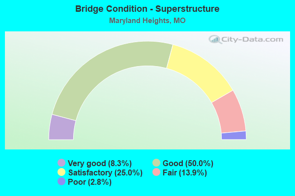
- Bridge Condition - Superstructure
- 8.3%Very good
- 50.0%Good
- 25.0%Satisfactory
- 13.9%Fair
- 2.8%Poor
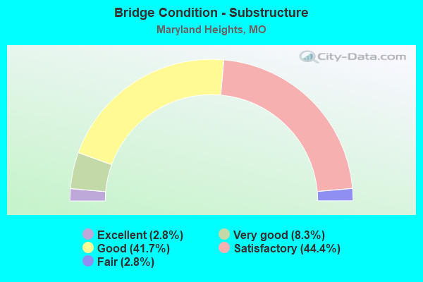
- Bridge Condition - Substructure
- 2.8%Excellent
- 8.3%Very good
- 41.7%Good
- 44.4%Satisfactory
- 2.8%Fair
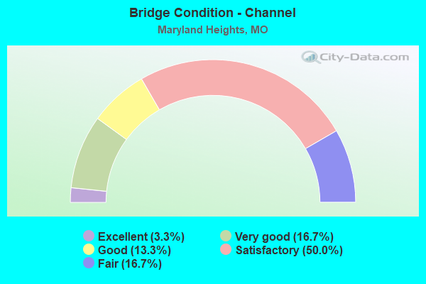
- Bridge Condition - Channel
- 3.3%Excellent
- 16.7%Very good
- 13.3%Good
- 50.0%Satisfactory
- 16.7%Fair
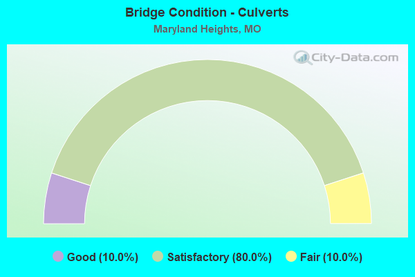
- Bridge Condition - Culverts
- 10.0%Good
- 80.0%Satisfactory
- 10.0%Fair
Find on map >> Show street view
Structure Number: 35173, Location: S 358 T 46 N R 5 E (Lat: 38.706547, Lng: -90.433631), Route carried "on" structure: City street , Year Built: 2016, Status: Open, Structure Length: 1.35m (4.43ft), Average Daily Traffic: 1,430 (year 2020), Truck Traffic: 13%, Average Future Daily Traffic: 1,931 (year 2040), Features Intersected: FEE FEE CR, Facility Carried by Structure: ADIE RD
Minimum Vertical Clearance: 30+ m (98+ ft), Kilometerpoint: 0.161, Lanes on structure: 3, Owner: City or Municipal Highway Agency, Approaching Roadway Width: 15.2m (49.9ft), Material/Design: Concrete, Design/Construction: Culvert, Number Of Spans In Main Unit: 1, Length of Maximum Span: 12.8m (42.0ft), Curb-To-Curb Width: 15.2m (49.9ft), Out-to-Out Width: 28.1m (92.2ft)
Condition: Channel: Excellent, Culverts: Good, Operating Rating: 76.5 metric tons, Method Used To Determine Operating Rating: Load Factor (LF), Inventory Rating: 45.9 metric tons, Method Used To Determine Inventory Rating: Load Factor (LF), Structural Evaluation: Better than present minimum criteria, Deck Geometry: Equal to present minimum criteria, Waterway Adequacy: Superior to present desirable criteria, Approach Roadway Alignment: Equal to present desirable criteria, Designated Inspection Frequency: Every 24 months, Inspection Date: December 2021
Find on map >> Show street view
Structure Number: 35383, Location: S 26 T 46 N R 5 E (Lat: 38.698264, Lng: -90.425833), Route carried "on" structure: County highway , Year Built: 2018, Status: Open, Structure Length: 1.68m (5.51ft), Average Daily Traffic: 5,192 (year 2020), Truck Traffic: 4%, Average Future Daily Traffic: 7,009 (year 2040), Features Intersected: E TRIB OF FEE FEE, Facility Carried by Structure: LACKLAND RD
Minimum Vertical Clearance: 30+ m (98+ ft), Kilometerpoint: 0.000, Lanes on structure: 2, Owner: County Highway Agency, Approaching Roadway Width: 9.8m (32.2ft), Skew: 1 degrees, Material/Design: Prestressed concrete, Design/Construction: Box Beam or Girders - Multiple, Number Of Spans In Main Unit: 1, Length of Maximum Span: 15.7m (51.5ft), Curb or Sidewalk Widths: Left: 1.5m (4.9ft), Right: 0.0m, Curb-To-Curb Width: 9.8m (32.2ft), Out-to-Out Width: 12.2m (40.0ft)
Condition: Deck: Very good, Superstructure: Very good, Substructure: Very good, Channel: Good, Operating Rating: 86.4 metric tons, Method Used To Determine Operating Rating: Load Factor (LF), Inventory Rating: 66.6 metric tons, Method Used To Determine Inventory Rating: Load Factor (LF), Structural Evaluation: Equal to present desirable criteria, Deck Geometry: Meets minimum limits, Waterway Adequacy: Better than present minimum criteria, Approach Roadway Alignment: Equal to present desirable criteria, Designated Inspection Frequency: Every 24 months, Inspection Date: March 2020, Deck Structure Type: Concrete Cast-file-Place, Wearing Surface/Protective System: Wearing Surface: Monolithic Concrete
Find on map >> Show street view
Structure Number: 3602, Location: S 18 T 40 N R 5 W (Lat: 38.202644, Lng: -91.536386), Route carried "on" structure: State highway EE, Year Built: 1986, Status: Open, Structure Length: 0.99m (3.25ft), Average Daily Traffic: 179 (year 2021), Truck Traffic: 12%, Average Future Daily Traffic: 233 (year 2041), Design Load: HS 20, Features Intersected: BOURBEUSE BR
Minimum Vertical Clearance: 30+ m (98+ ft), Kilometerpoint: 17.098, Lanes on structure: 2, Owner: State Highway Agency, Approaching Roadway Width: 8.5m (27.9ft), Skew: 4 degrees, Material/Design: Concrete continuous, Design/Construction: Culvert, Number Of Spans In Main Unit: 2, Length of Maximum Span: 3.7m (12.1ft)
Condition: Channel: Satisfactory, Culverts: Satisfactory, Inventory Rating: 73.8 metric tons, Method Used To Determine Inventory Rating: Load Factor (LF), Structural Evaluation: Equal to present minimum criteria, Waterway Adequacy: Equal to present desirable criteria, Approach Roadway Alignment: Equal to present desirable criteria, Designated Inspection Frequency: Every 24 months, Inspection Date: November 2020
Find on map >> Show street view
Structure Number: 3602, Location: S 24 T 46 N R 5 E (Lat: 38.707494, Lng: -90.408872), Route carried "on" structure: City street , Year Built: 2019, Status: Open, Structure Length: 3.44m (11.29ft), Average Daily Traffic: 14,425 (year 2021), Truck Traffic: 5%, Average Future Daily Traffic: 20,195 (year 2041), Features Intersected: US 67, Facility Carried by Structure: DORSETT RD E
Minimum Vertical Clearance: 30+ m (98+ ft), Kilometerpoint: 6.043, Lanes on structure: 4, Lanes under structure: 4, Owner: State Highway Agency, Approaching Roadway Width: 24.7m (81.0ft), Skew: 2 degrees, Material/Design: Steel, Design/Construction: Stringer/Multi-beam, Number Of Spans In Main Unit: 1, Length of Maximum Span: 33.2m (108.9ft), Curb-To-Curb Width: 29.3m (96.1ft), Out-to-Out Width: 30.1m (98.8ft)
Condition: Deck: Good, Superstructure: Good, Substructure: Excellent, Operating Rating: 97.2 metric tons, Method Used To Determine Operating Rating: Load Factor (LF), Inventory Rating: 58.5 metric tons, Method Used To Determine Inventory Rating: Load Factor (LF), Structural Evaluation: Better than present minimum criteria, Deck Geometry: Superior to present desirable criteria, Underclear: Somewhat better than minimum adequacy, Approach Roadway Alignment: Equal to present desirable criteria, Designated Inspection Frequency: Every 24 months, Inspection Date: September 2020, Deck Structure Type: Concrete Cast-file-Place, Wearing Surface/Protective System: Wearing Surface: Monolithic Concrete, Deck Protection: Epoxy Coated Reinforcing
Find on map >> Show street view
Structure Number: 4403, Location: S 28 T 46 N R 5 E (Lat: 38.695822, Lng: -90.464722), Route carried "on" structure: City street , Year Built: 1997, Status: Open, Structure Length: 6.61m (21.69ft), Average Daily Traffic: 17,654 (year 2021), Truck Traffic: 5%, Average Future Daily Traffic: 24,716 (year 2041), Design Load: HS 20, Features Intersected: MO 364, Facility Carried by Structure: BENNINGTON PL N
Minimum Vertical Clearance: 30+ m (98+ ft), Kilometerpoint: 0.301, Lanes on structure: 7, Lanes under structure: 8, Owner: State Highway Agency, Approaching Roadway Width: 29.9m (98.1ft), Material/Design: Steel continuous, Design/Construction: Stringer/Multi-beam, Number Of Spans In Main Unit: 2, Length of Maximum Span: 33.4m (109.6ft), Curb or Sidewalk Widths: Left: 1.7m (5.6ft), Right: 1.7m (5.6ft), Curb-To-Curb Width: 28.4m (93.2ft), Out-to-Out Width: 32.6m (107.0ft)
Condition: Deck: Satisfactory, Superstructure: Satisfactory, Substructure: Satisfactory, Operating Rating: 61.2 metric tons, Method Used To Determine Operating Rating: Load Factor (LF), Inventory Rating: 36.0 metric tons, Method Used To Determine Inventory Rating: Load Factor (LF), Structural Evaluation: Equal to present minimum criteria, Deck Geometry: Somewhat better than minimum adequacy, Underclear: Meets minimum limits, Approach Roadway Alignment: Equal to present desirable criteria, Designated Inspection Frequency: Every 24 months, Inspection Date: September 2020, Deck Structure Type: Concrete Cast-file-Place, Wearing Surface/Protective System: Wearing Surface: Latex Concrete, Deck Protection: Epoxy Coated Reinforcing
Find on map >> Show street view
Structure Number: 12063, Location: S 29 T 46 N R 5 E (Lat: 38.706114, Lng: -90.478436), Route carried "under" structure: State highway 364, Year Built: 1999, Structure Length: 0. m, Average Daily Traffic: 38,396 (year 2021), Truck Traffic: 5%, Features Intersected: MO 364, Facility Carried by Structure: SEVEN PINES DR S
Minimum Vertical Clearance: 5.16m (16.93ft), Kilometerpoint: 30.940, Lanes on structure: 2, Lanes under structure: 5, Material/Design: Steel continuous, Design/Construction: Stringer/Multi-beam, Length of Maximum Span: 30.9m (101.4ft)
Find on map >> Show street view
Structure Number: 12063, Location: S 29 T 46 N R 5 E (Lat: 38.706114, Lng: -90.478436), Route carried "under" structure: State highway 364, Year Built: 1999, Structure Length: 0. m, Average Daily Traffic: 34,896 (year 2021), Truck Traffic: 13%, Features Intersected: MO 364, Facility Carried by Structure: SEVEN PINES DR S
Minimum Vertical Clearance: 5.49m (18.01ft), Kilometerpoint: 3.484, Lanes on structure: 2, Lanes under structure: 5, Material/Design: Steel continuous, Design/Construction: Stringer/Multi-beam, Length of Maximum Span: 30.9m (101.4ft)
Find on map >> Show street view
Structure Number: 12064, Location: S 29 T 46 N R 5 E (Lat: 38.705281, Lng: -90.475494), Route carried "under" structure: State highway 364, Year Built: 1999, Structure Length: 0. m, Average Daily Traffic: 38,396 (year 2021), Truck Traffic: 5%, Features Intersected: MO 364, Facility Carried by Structure: AMIOT DR E
Minimum Vertical Clearance: 5.59m (18.34ft), Kilometerpoint: 31.202, Lanes on structure: 2, Lanes under structure: 5, Material/Design: Prestressed concrete continuous, Design/Construction: Tee Beam, Length of Maximum Span: 32.7m (107.3ft)
Find on map >> Show street view
Structure Number: 12064, Location: S 29 T 46 N R 5 E (Lat: 38.705281, Lng: -90.475494), Route carried "under" structure: State highway 364, Year Built: 1999, Structure Length: 0. m, Average Daily Traffic: 34,896 (year 2021), Truck Traffic: 13%, Features Intersected: MO 364, Facility Carried by Structure: AMIOT DR E
Minimum Vertical Clearance: 5.77m (18.93ft), Kilometerpoint: 3.180, Lanes on structure: 2, Lanes under structure: 5, Material/Design: Prestressed concrete continuous, Design/Construction: Tee Beam, Length of Maximum Span: 32.7m (107.3ft)
Find on map >> Show street view
Structure Number: 12108, Location: S 24 T 46 N R 4 E (Lat: 38.719053, Lng: -90.510444), Route carried "under" structure: State highway 364, Year Built: 2001, Structure Length: 0. m, Average Daily Traffic: 36,942 (year 2021), Truck Traffic: 5%, Features Intersected: MO 364, Facility Carried by Structure: RIVER VALLEY DR S
Minimum Vertical Clearance: 5.64m (18.50ft), Kilometerpoint: 27.344, Lanes on structure: 2, Lanes under structure: 5, Material/Design: Steel continuous, Design/Construction: Stringer/Multi-beam, Length of Maximum Span: 39.9m (130.9ft)
Find on map >> Show street view
Structure Number: 12108, Location: S 24 T 46 N R 4 E (Lat: 38.719053, Lng: -90.510444), Route carried "under" structure: State highway 364, Year Built: 2001, Structure Length: 0. m, Average Daily Traffic: 40,154 (year 2021), Truck Traffic: 13%, Features Intersected: MO 364, Facility Carried by Structure: RIVER VALLEY DR S
Minimum Vertical Clearance: 5.64m (18.50ft), Kilometerpoint: 7.026, Lanes on structure: 2, Lanes under structure: 5, Material/Design: Steel continuous, Design/Construction: Stringer/Multi-beam, Length of Maximum Span: 39.9m (130.9ft)
Find on map >> Show street view
Structure Number: 12136, Location: S 3094 T 46 N R 5 E (Lat: 38.706364, Lng: -90.496281), Route carried "under" structure: City street , Year Built: 2001, Structure Length: 0. m, Average Daily Traffic: 2,634 (year 2021), Truck Traffic: 3%, Features Intersected: CST CREVE COEUR MILL RD, Facility Carried by Structure: MO 364 E
Minimum Vertical Clearance: 9.42m (30.91ft), Kilometerpoint: 1.323, Lanes on structure: 6, Lanes under structure: 2, Material/Design: Steel continuous, Design/Construction: Stringer/Multi-beam, Length of Maximum Span: 43.5m (142.7ft)
Find on map >> Show street view
Structure Number: 12138, Location: S 3094 T 46 N R 5 E (Lat: 38.706586, Lng: -90.496239), Route carried "under" structure: City street , Year Built: 2001, Structure Length: 0. m, Average Daily Traffic: 2,634 (year 2021), Truck Traffic: 3%, Features Intersected: CST CREVE COEUR MILL RD, Facility Carried by Structure: MO 364 W
Minimum Vertical Clearance: 9.52m (31.23ft), Kilometerpoint: 1.323, Lanes on structure: 5, Lanes under structure: 2, Material/Design: Steel continuous, Design/Construction: Stringer/Multi-beam, Length of Maximum Span: 43.5m (142.7ft)
Find on map >> Show street view
Structure Number: 12141, Location: S 19 T 46 N R 5 E (Lat: 38.707403, Lng: -90.502047), Route carried "under" structure: State highway 141, Year Built: 2001, Structure Length: 0. m, Average Daily Traffic: 15,701 (year 2021), Truck Traffic: 5%, Features Intersected: MO 141, Facility Carried by Structure: MO 364 E
Minimum Vertical Clearance: 6.63m (21.75ft), Kilometerpoint: 37.907, Lanes on structure: 4, Lanes under structure: 4, Material/Design: Prestressed concrete continuous, Design/Construction: Stringer/Multi-beam, Length of Maximum Span: 23.4m (76.8ft)
Find on map >> Show street view
Structure Number: 12141, Location: S 19 T 46 N R 5 E (Lat: 38.707403, Lng: -90.502047), Route carried "under" structure: Ramp State highway , Year Built: 2001, Structure Length: 0. m, Average Daily Traffic: 10,837 (year 2021), Truck Traffic: 10%, Features Intersected: RP MO364E TO MO141N, Facility Carried by Structure: MO 364 E
Minimum Vertical Clearance: 6.96m (22.83ft), Kilometerpoint: 0.776, Lanes on structure: 4, Lanes under structure: 1, Material/Design: Prestressed concrete continuous, Design/Construction: Stringer/Multi-beam, Length of Maximum Span: 23.4m (76.8ft)
Find on map >> Show street view
Structure Number: 12141, Location: S 19 T 46 N R 5 E (Lat: 38.707403, Lng: -90.502047), Route carried "under" structure: State highway 141, Year Built: 2001, Structure Length: 0. m, Average Daily Traffic: 14,249 (year 2021), Truck Traffic: 5%, Features Intersected: MO 141, Facility Carried by Structure: MO 364 E
Minimum Vertical Clearance: 6.58m (21.59ft), Kilometerpoint: 11.755, Lanes on structure: 4, Lanes under structure: 4, Material/Design: Prestressed concrete continuous, Design/Construction: Stringer/Multi-beam, Length of Maximum Span: 23.4m (76.8ft)
Find on map >> Show street view
Structure Number: 12143, Location: S 19 T 46 N R 5 E (Lat: 38.707603, Lng: -90.502008), Route carried "under" structure: State highway 141, Year Built: 2001, Structure Length: 0. m, Average Daily Traffic: 13,855 (year 2021), Truck Traffic: 5%, Features Intersected: MO 141, Facility Carried by Structure: MO 364 W
Minimum Vertical Clearance: 5.39m (17.68ft), Kilometerpoint: 37.934, Lanes on structure: 5, Lanes under structure: 4, Material/Design: Prestressed concrete continuous, Design/Construction: Stringer/Multi-beam, Length of Maximum Span: 23.5m (77.1ft)
Find on map >> Show street view
Structure Number: 12143, Location: S 19 T 46 N R 5 E (Lat: 38.707603, Lng: -90.502008), Route carried "under" structure: State highway 141, Year Built: 2001, Structure Length: 0. m, Average Daily Traffic: 14,249 (year 2021), Truck Traffic: 5%, Features Intersected: MO 141, Facility Carried by Structure: MO 364 W
Minimum Vertical Clearance: 5.31m (17.42ft), Kilometerpoint: 11.729, Lanes on structure: 5, Lanes under structure: 4, Material/Design: Prestressed concrete continuous, Design/Construction: Stringer/Multi-beam, Length of Maximum Span: 23.5m (77.1ft)
Find on map >> Show street view
Structure Number: 12143, Location: S 19 T 46 N R 5 E (Lat: 38.707603, Lng: -90.502008), Route carried "under" structure: Ramp State highway , Year Built: 2001, Structure Length: 0. m, Average Daily Traffic: 10,837 (year 2021), Truck Traffic: 10%, Features Intersected: RP MO364E TO MO141N, Facility Carried by Structure: MO 364 W
Minimum Vertical Clearance: 5.56m (18.24ft), Kilometerpoint: 0.801, Lanes on structure: 5, Lanes under structure: 1, Material/Design: Prestressed concrete continuous, Design/Construction: Stringer/Multi-beam, Length of Maximum Span: 23.5m (77.1ft)
Find on map >> Show street view
Structure Number: 1233, Location: S 1312 T 46 N R 5 E (Lat: 38.703922, Lng: -90.449883), Route carried "under" structure: City street , Year Built: 1965, Structure Length: 0. m, Average Daily Traffic: 11,306 (year 2021), Truck Traffic: 3%, Features Intersected: CST WEST PORT PLAZA DR, Facility Carried by Structure: IS 270 E
Minimum Vertical Clearance: 6.32m (20.73ft), Kilometerpoint: 0.117, Lanes on structure: 10, Lanes under structure: 4, Material/Design: Concrete continuous, Design/Construction: Slab, Length of Maximum Span: 18.9m (62.0ft)
Find on map >> Show street view
Structure Number: 2732, Location: S 4 T 46 N R 5 E (Lat: 38.755567, Lng: -90.458628), Route carried "under" structure: State highway 141, Year Built: 1971, Structure Length: 0. m, Average Daily Traffic: 5,076 (year 2021), Truck Traffic: 5%, Features Intersected: MO 141, Facility Carried by Structure: IS 70 E
Minimum Vertical Clearance: 4.57m (14.99ft), Kilometerpoint: 4.627, Lanes on structure: 12, Lanes under structure: 3, Material/Design: Steel, Design/Construction: Stringer/Multi-beam, Length of Maximum Span: 16.8m (55.1ft)
Find on map >> Show street view
Structure Number: 2732, Location: S 4 T 46 N R 5 E (Lat: 38.755567, Lng: -90.458628), Route carried "under" structure: State highway 141, Year Built: 1971, Structure Length: 0. m, Average Daily Traffic: 13,855 (year 2021), Truck Traffic: 5%, Features Intersected: MO 141, Facility Carried by Structure: IS 70 E
Minimum Vertical Clearance: 4.52m (14.83ft), Kilometerpoint: 45.021, Lanes on structure: 12, Lanes under structure: 3, Material/Design: Steel, Design/Construction: Stringer/Multi-beam, Length of Maximum Span: 16.8m (55.1ft)
Find on map >> Show street view
Structure Number: 2973, Location: S 1312 T 46 N R 5 E (Lat: 38.699669, Lng: -90.442933), Route carried "under" structure: State highway D, Year Built: 1978, Structure Length: 0. m, Average Daily Traffic: 30,723 (year 2021), Truck Traffic: 5%, Features Intersected: RT D
Minimum Vertical Clearance: 5.26m (17.26ft), Kilometerpoint: 1.101, Lanes on structure: 5, Lanes under structure: 5, Material/Design: Steel continuous, Design/Construction: Stringer/Multi-beam, Length of Maximum Span: 25.0m (82.0ft)
Find on map >> Show street view
Structure Number: 2973, Location: S 1312 T 46 N R 5 E (Lat: 38.699669, Lng: -90.442933), Route carried "under" structure: State highway D, Year Built: 1978, Structure Length: 0. m, Average Daily Traffic: 30,155 (year 2021), Truck Traffic: 5%, Features Intersected: RT D
Minimum Vertical Clearance: 4.93m (16.17ft), Kilometerpoint: 24.211, Lanes on structure: 5, Lanes under structure: 5, Material/Design: Steel continuous, Design/Construction: Stringer/Multi-beam, Length of Maximum Span: 25.0m (82.0ft)
Find on map >> Show street view
Structure Number: 3149, Location: S 729 T 46 N R 5 E (Lat: 38.742014, Lng: -90.441069), Route carried "under" structure: Interstate 270, Year Built: 1979, Structure Length: 0. m, Average Daily Traffic: 67,218 (year 2021), Truck Traffic: 12%, Features Intersected: IS 270, Facility Carried by Structure: MCKELVEY RD S
Minimum Vertical Clearance: 5.13m (16.83ft), Kilometerpoint: 31.975, Lanes on structure: 4, Lanes under structure: 5, Material/Design: Steel continuous, Design/Construction: Stringer/Multi-beam, Length of Maximum Span: 36.3m (119.1ft)
Find on map >> Show street view
Structure Number: 3149, Location: S 729 T 46 N R 5 E (Lat: 38.742014, Lng: -90.441069), Route carried "under" structure: Interstate 270, Year Built: 1979, Structure Length: 0. m, Average Daily Traffic: 67,876 (year 2021), Truck Traffic: 12%, Features Intersected: IS 270, Facility Carried by Structure: MCKELVEY RD S
Minimum Vertical Clearance: 5.28m (17.32ft), Kilometerpoint: 25.627, Lanes on structure: 4, Lanes under structure: 6, Material/Design: Steel continuous, Design/Construction: Stringer/Multi-beam, Length of Maximum Span: 36.3m (119.1ft)
Find on map >> Show street view
Structure Number: 32823, Location: S 22 T 46 N R 5 E (Lat: 38.714539, Lng: -90.447328), Route carried "under" structure: City street , Year Built: 2009, Structure Length: 0. m, Average Daily Traffic: 14,514 (year 2021), Truck Traffic: 5%, Features Intersected: CST DORSETT RD, Facility Carried by Structure: IS 270 E
Minimum Vertical Clearance: 4.60m (15.09ft), Kilometerpoint: 2.483, Lanes on structure: 8, Lanes under structure: 3, Material/Design: Prestressed concrete continuous, Design/Construction: Tee Beam, Length of Maximum Span: 23.2m (76.1ft)
Find on map >> Show street view
Structure Number: 32823, Location: S 22 T 46 N R 5 E (Lat: 38.714539, Lng: -90.447328), Route carried "under" structure: City street , Year Built: 2009, Structure Length: 0. m, Average Daily Traffic: 14,729 (year 2021), Truck Traffic: 5%, Features Intersected: CST DORSETT RD, Facility Carried by Structure: IS 270 E
Minimum Vertical Clearance: 4.57m (14.99ft), Kilometerpoint: 3.687, Lanes on structure: 8, Lanes under structure: 3, Material/Design: Prestressed concrete continuous, Design/Construction: Tee Beam, Length of Maximum Span: 23.2m (76.1ft)
Find on map >> Show street view
Structure Number: 34159, Location: S 433 T 46 N R 5 E (Lat: 38.692389, Lng: -90.499250), Route carried "under" structure: City street , Year Built: 2012, Structure Length: 0. m, Average Daily Traffic: 6,002 (year 2021), Truck Traffic: 10%, Features Intersected: CST WATER WORKS DR, Facility Carried by Structure: MO 141 S
Minimum Vertical Clearance: 7.19m (23.59ft), Kilometerpoint: 0.747, Lanes on structure: 6, Lanes under structure: 2, Material/Design: Prestressed concrete, Design/Construction: Stringer/Multi-beam, Length of Maximum Span: 39.2m (128.6ft)
Find on map >> Show street view
Structure Number: 3602, Location: S 24 T 46 N R 5 E (Lat: 38.707494, Lng: -90.408872), Route carried "under" structure: US 67, Year Built: 2019, Structure Length: 0. m, Average Daily Traffic: 10,762 (year 2021), Truck Traffic: 10%, Features Intersected: US 67, Facility Carried by Structure: DORSETT RD E
Minimum Vertical Clearance: 4.88m (16.01ft), Kilometerpoint: 33.112, Lanes on structure: 4, Lanes under structure: 2, Material/Design: Steel, Design/Construction: Stringer/Multi-beam, Length of Maximum Span: 33.2m (108.9ft)
Find on map >> Show street view
Structure Number: 3602, Location: S 24 T 46 N R 5 E (Lat: 38.707494, Lng: -90.408872), Route carried "under" structure: US 67, Year Built: 2019, Structure Length: 0. m, Average Daily Traffic: 10,525 (year 2021), Truck Traffic: 8%, Features Intersected: US 67, Facility Carried by Structure: DORSETT RD E
Minimum Vertical Clearance: 4.88m (16.01ft), Kilometerpoint: 285.019, Lanes on structure: 4, Lanes under structure: 2, Material/Design: Steel, Design/Construction: Stringer/Multi-beam, Length of Maximum Span: 33.2m (108.9ft)
Find on map >> Show street view
Structure Number: 4403, Location: S 28 T 46 N R 5 E (Lat: 38.695822, Lng: -90.464722), Route carried "under" structure: State highway 364, Year Built: 1997, Structure Length: 0. m, Average Daily Traffic: 38,396 (year 2021), Truck Traffic: 5%, Features Intersected: MO 364, Facility Carried by Structure: BENNINGTON PL N
Minimum Vertical Clearance: 5.13m (16.83ft), Kilometerpoint: 32.716, Lanes on structure: 7, Lanes under structure: 4, Material/Design: Steel continuous, Design/Construction: Stringer/Multi-beam, Length of Maximum Span: 33.4m (109.6ft)
Find on map >> Show street view
Structure Number: 4403, Location: S 28 T 46 N R 5 E (Lat: 38.695822, Lng: -90.464722), Route carried "under" structure: State highway 364, Year Built: 1997, Structure Length: 0. m, Average Daily Traffic: 34,896 (year 2021), Truck Traffic: 13%, Features Intersected: MO 364, Facility Carried by Structure: BENNINGTON PL N
Minimum Vertical Clearance: 5.13m (16.83ft), Kilometerpoint: 1.699, Lanes on structure: 7, Lanes under structure: 4, Material/Design: Steel continuous, Design/Construction: Stringer/Multi-beam, Length of Maximum Span: 33.4m (109.6ft)