Bridge Statistics for Mason City, Iowa (IA)
Condition, Traffic, Stress, Structural Evaluation, Project Costs
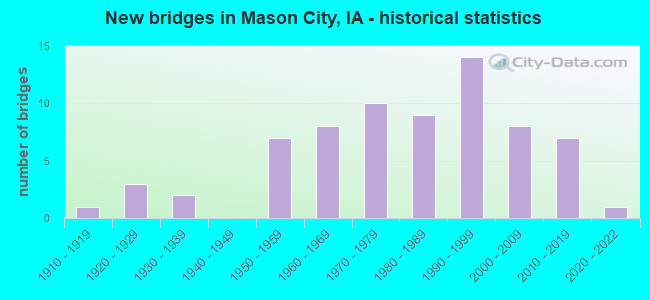
- New bridges - historical statistics
- 11910-1919
- 31920-1929
- 21930-1939
- 71950-1959
- 81960-1969
- 101970-1979
- 91980-1989
- 141990-1999
- 82000-2009
- 72010-2019
- 12020-2022
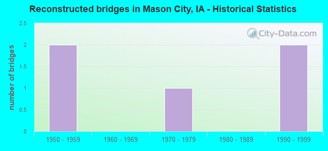
- Reconstructed bridges - Historical Statistics
- 21950-1959
- 01960-1969
- 11970-1979
- 01980-1989
- 21990-1999
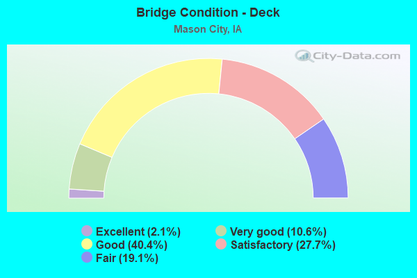
- Bridge Condition - Deck
- 2.1%Excellent
- 10.6%Very good
- 40.4%Good
- 27.7%Satisfactory
- 19.1%Fair

- Bridge Condition - Superstructure
- 2.1%Excellent
- 29.2%Very good
- 33.3%Good
- 20.8%Satisfactory
- 10.4%Fair
- 2.1%Poor
- 2.1%Serious
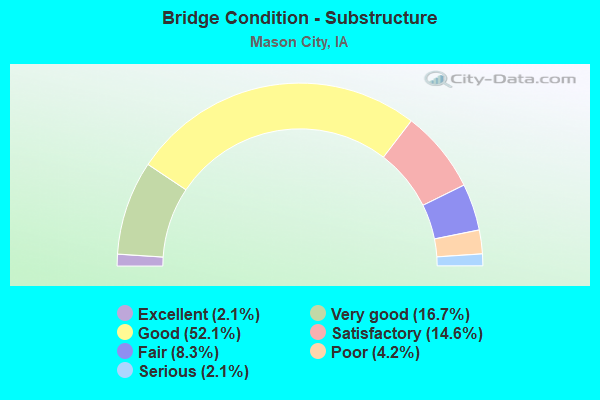
- Bridge Condition - Substructure
- 2.1%Excellent
- 16.7%Very good
- 52.1%Good
- 14.6%Satisfactory
- 8.3%Fair
- 4.2%Poor
- 2.1%Serious
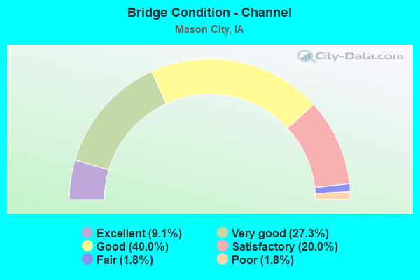
- Bridge Condition - Channel
- 9.1%Excellent
- 27.3%Very good
- 40.0%Good
- 20.0%Satisfactory
- 1.8%Fair
- 1.8%Poor
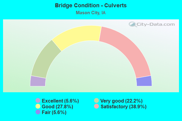
- Bridge Condition - Culverts
- 5.6%Excellent
- 22.2%Very good
- 27.8%Good
- 38.9%Satisfactory
- 5.6%Fair
Find on map >> Show street view
Structure Number: 794, Location: 000000000 (Lat: 43.146472, Lng: -93.223942), Route carried "on" structure: City street , Year Built: 1962, Status: Open, Structure Length: 1.28m (4.20ft), Average Daily Traffic: 3,210 (year 2021), Average Future Daily Traffic: 3,210 (year 2042), Design Load: H 20, Features Intersected: CHESLEA CREEK, Facility Carried by Structure: 6TH ST SW
Minimum Vertical Clearance: 30+ m (98+ ft), Kilometerpoint: 0.274, Lanes on structure: 2, Owner: City or Municipal Highway Agency, Approaching Roadway Width: 9.1m (29.9ft), Material/Design: Concrete, Design/Construction: Frame, Number Of Spans In Main Unit: 1, Length of Maximum Span: 12.8m (42.0ft), Curb or Sidewalk Widths: Left: 1.5m (4.9ft), Right: 1.5m (4.9ft), Curb-To-Curb Width: 9.2m (30.2ft), Out-to-Out Width: 12.8m (42.0ft)
Condition: Deck: Satisfactory, Superstructure: Satisfactory, Substructure: Good, Channel: Good, Operating Rating: 31.5 metric tons, Method Used To Determine Operating Rating: Allowable Stress (AS), Inventory Rating: 22.5 metric tons, Method Used To Determine Inventory Rating: Allowable Stress (AS), Structural Evaluation: Equal to present minimum criteria, Deck Geometry: Meets minimum limits, Waterway Adequacy: Equal to present desirable criteria, Approach Roadway Alignment: Equal to present desirable criteria, Length Of Structure Improvement: 6.40m (21.00ft), Designated Inspection Frequency: Every 24 months, Inspection Date: January 2022, Bridge Improvement Cost: $175,000, Roadway Improvement Cost: $35,000, Deck Structure Type: Concrete Cast-file-Place, Wearing Surface/Protective System: Wearing Surface: Monolithic Concrete
Find on map >> Show street view
Structure Number: 798, Location: 000000000 (Lat: 43.150917, Lng: -93.207281), Route carried "on" structure: City street , Year Built: 1966, Status: Open, Structure Length: 3.35m (10.99ft), Average Daily Traffic: 1,620 (year 2017), Average Future Daily Traffic: 1,620 (year 2042), Design Load: H 20, Features Intersected: WILLOW CREEK, Facility Carried by Structure: 1ST ST SW
Minimum Vertical Clearance: 30+ m (98+ ft), Kilometerpoint: 1.120, Lanes on structure: 2, Owner: City or Municipal Highway Agency, Approaching Roadway Width: 12.5m (41.0ft), Skew: 3 degrees, Material/Design: Concrete continuous, Design/Construction: Slab, Number Of Spans In Main Unit: 3, Length of Maximum Span: 13.1m (43.0ft), Curb or Sidewalk Widths: Left: 1.5m (4.9ft), Right: 1.5m (4.9ft), Curb-To-Curb Width: 12.2m (40.0ft), Out-to-Out Width: 15.8m (51.8ft)
Condition: Deck: Satisfactory, Superstructure: Satisfactory, Substructure: Good, Channel: Very good, Operating Rating: 41.9 metric tons, Method Used To Determine Operating Rating: Allowable Stress (AS), Inventory Rating: 27.8 metric tons, Method Used To Determine Inventory Rating: Allowable Stress (AS), Structural Evaluation: Equal to present minimum criteria, Deck Geometry: Better than present minimum criteria, Waterway Adequacy: Equal to present desirable criteria, Approach Roadway Alignment: Equal to present desirable criteria, Designated Inspection Frequency: Every 24 months, Inspection Date: January 2022, Deck Structure Type: Concrete Cast-file-Place, Wearing Surface/Protective System: Wearing Surface: Monolithic Concrete
Find on map >> Show street view
Structure Number: 799, Location: 000000000 (Lat: 43.151847, Lng: -93.191725), Route carried "on" structure: City street , Year Built: 1920, Status: Open, Structure Length: 1.95m (6.40ft), Average Daily Traffic: 6,700 (year 2009), Average Future Daily Traffic: 6,700 (year 2042), Features Intersected: WILLOW CREEK, Facility Carried by Structure: E STATE ST
Minimum Vertical Clearance: 30+ m (98+ ft), Kilometerpoint: 0.760, Lanes on structure: 2, Owner: City or Municipal Highway Agency, Approaching Roadway Width: 11.3m (37.1ft), Material/Design: Concrete, Design/Construction: Arch - Deck, Number Of Spans In Main Unit: 1, Length of Maximum Span: 18.9m (62.0ft), Curb or Sidewalk Widths: Left: 1.5m (4.9ft), Right: 1.5m (4.9ft), Curb-To-Curb Width: 11.3m (37.1ft), Out-to-Out Width: 15.6m (51.2ft)
Condition: Superstructure: Satisfactory, Substructure: Satisfactory, Channel: Very good, Operating Rating: 45.4 metric tons, Method Used To Determine Operating Rating: Field evaluation and documented engineering judgment, Inventory Rating: 32.7 metric tons, Method Used To Determine Inventory Rating: Field evaluation and documented engineering judgment, Structural Evaluation: Equal to present minimum criteria, Deck Geometry: Meets minimum limits, Waterway Adequacy: Equal to present desirable criteria, Approach Roadway Alignment: Equal to present desirable criteria, Length Of Structure Improvement: 8.60m (28.22ft), Designated Inspection Frequency: Every 24 months, Inspection Date: January 2022, Bridge Improvement Cost: $291,000, Roadway Improvement Cost: $58,000, Deck Structure Type: Concrete Cast-file-Place, Wearing Surface/Protective System: Wearing Surface: Bituminous
Find on map >> Show street view
Structure Number: 8, Location: 000000000 (Lat: 43.152808, Lng: -93.223222), Route carried "on" structure: City street , Year Built: 1955, Status: Posted for load-capacity, Structure Length: 0.85m (2.79ft), Average Daily Traffic: 2,620 (year 2021), Average Future Daily Traffic: 2,620 (year 2042), Design Load: H 20, Features Intersected: CHESALEA CREEK, Facility Carried by Structure: 1ST ST NW
Minimum Vertical Clearance: 30+ m (98+ ft), Kilometerpoint: 0.835, Lanes on structure: 2, Owner: City or Municipal Highway Agency, Approaching Roadway Width: 9.1m (29.9ft), Material/Design: Steel, Design/Construction: Culvert, Number Of Spans In Main Unit: 1, Length of Maximum Span: 8.5m (27.9ft)
Condition: Channel: Fair, Culverts: Satisfactory, Operating Rating: 31.5 metric tons, Method Used To Determine Operating Rating: Field evaluation and documented engineering judgment, Inventory Rating: 22.5 metric tons, Method Used To Determine Inventory Rating: Field evaluation and documented engineering judgment, Structural Evaluation: Equal to present minimum criteria, Waterway Adequacy: Equal to present desirable criteria, Approach Roadway Alignment: Better than present minimum criteria, Bridge Posting: Required (Relationship of Operating Rating to Maximum Legal Load: > 39.9% below), Length Of Structure Improvement: 5.00m (16.40ft), Designated Inspection Frequency: Every 24 months, Inspection Date: January 2022, Bridge Improvement Cost: $169,000, Roadway Improvement Cost: $34,000
Find on map >> Show street view
Structure Number: 8021, Location: 0.1 Mi E & W Taft Ave (Lat: 43.162764, Lng: -93.239097), Route carried "on" structure: City street , Year Built: 2019, Status: Open, Structure Length: 2.96m (9.71ft), Average Daily Traffic: 8,300 (year 2021), Average Future Daily Traffic: 8,300 (year 2042), Design Load: HL 93, Features Intersected: WILLOW CREEK, Facility Carried by Structure: 12TH ST NW
Minimum Vertical Clearance: 30+ m (98+ ft), Kilometerpoint: 2.554, Lanes on structure: 2, Owner: City or Municipal Highway Agency, Approaching Roadway Width: 13.4m (44.0ft), Material/Design: Prestressed concrete, Design/Construction: Stringer/Multi-beam, Number Of Spans In Main Unit: 1, Length of Maximum Span: 29.6m (97.1ft), Curb or Sidewalk Widths: Left: 3.0m (9.8ft), Right: 0.0m, Curb-To-Curb Width: 11.6m (38.1ft), Out-to-Out Width: 15.9m (52.2ft)
Condition: Deck: Excellent, Superstructure: Excellent, Substructure: Excellent, Channel: Excellent, Operating Rating: 53.1 metric tons, Method Used To Determine Operating Rating: Load and Resistance Factor Rating (LRFR) rating reported by rating factor(RF) method using HL-93 loadings, Inventory Rating: 42.1 metric tons, Method Used To Determine Inventory Rating: Load and Resistance Factor Rating (LRFR) rating reported by rating factor(RF) method using HL-93 loadings, Structural Evaluation: Superior to present desirable criteria, Deck Geometry: Somewhat better than minimum adequacy, Waterway Adequacy: Superior to present desirable criteria, Approach Roadway Alignment: Equal to present desirable criteria, Designated Inspection Frequency: Every 24 months, Inspection Date: January 2022, Deck Structure Type: Concrete Cast-file-Place, Wearing Surface/Protective System: Wearing Surface: Monolithic Concrete, Deck Protection: Epoxy Coated Reinforcing
Find on map >> Show street view
Structure Number: 8045, Location: 000000000 (Lat: 43.162564, Lng: -93.145978), Route carried "on" structure: City street , Year Built: 1920, Year Reconstructed: 1961, Status: Posted for load, Structure Length: 0.82m (2.69ft), Average Daily Traffic: 2,750 (year 2017), Average Future Daily Traffic: 2,750 (year 2042), Features Intersected: CREEK, Facility Carried by Structure: 12TH ST NE
Minimum Vertical Clearance: 30+ m (98+ ft), Kilometerpoint: 3.948, Lanes on structure: 2, Owner: City or Municipal Highway Agency, Approaching Roadway Width: 10.4m (34.1ft), Material/Design: Concrete, Design/Construction: Stringer/Multi-beam, Number Of Spans In Main Unit: 1, Length of Maximum Span: 7.6m (24.9ft), Curb-To-Curb Width: 8.5m (27.9ft), Out-to-Out Width: 9.0m (29.5ft)
Condition: Deck: Fair, Superstructure: Serious, Substructure: Poor, Channel: Satisfactory, Operating Rating: 35.4 metric tons, Method Used To Determine Operating Rating: Allowable Stress (AS), Inventory Rating: 18.9 metric tons, Method Used To Determine Inventory Rating: Allowable Stress (AS), Structural Evaluation: High priority of corrective action, Deck Geometry: Meets minimum limits, Waterway Adequacy: Equal to present minimum criteria, Approach Roadway Alignment: Equal to present desirable criteria, Bridge Posting: Required (Relationship of Operating Rating to Maximum Legal Load: 0.1 - 9.9% below), Length Of Structure Improvement: 4.60m (15.09ft), Designated Inspection Frequency: Every 24 months, Inspection Date: January 2022, Bridge Improvement Cost: $129,000, Roadway Improvement Cost: $26,000, Deck Structure Type: Concrete Cast-file-Place, Wearing Surface/Protective System: Wearing Surface: Bituminous
Find on map >> Show street view
Structure Number: 8071, Location: 000000000 (Lat: 43.151964, Lng: -93.223914), Route carried "on" structure: City street , Year Built: 1989, Status: Open, Structure Length: 1.37m (4.49ft), Average Daily Traffic: 805 (year 1998), Average Future Daily Traffic: 805 (year 2042), Design Load: HS 20, Features Intersected: CHESALEA CREEK, Facility Carried by Structure: WILLOWBROOK DR
Minimum Vertical Clearance: 30+ m (98+ ft), Kilometerpoint: 0.592, Lanes on structure: 2, Owner: City or Municipal Highway Agency, Approaching Roadway Width: 8.2m (26.9ft), Material/Design: Concrete, Design/Construction: Frame, Number Of Spans In Main Unit: 1, Length of Maximum Span: 12.2m (40.0ft), Curb or Sidewalk Widths: Left: 2.1m (6.9ft), Right: 2.1m (6.9ft), Curb-To-Curb Width: 9.1m (29.9ft), Out-to-Out Width: 13.1m (43.0ft)
Condition: Deck: Good, Superstructure: Good, Substructure: Good, Channel: Very good, Operating Rating: 45.4 metric tons, Method Used To Determine Operating Rating: Allowable Stress (AS), Inventory Rating: 32.7 metric tons, Method Used To Determine Inventory Rating: Allowable Stress (AS), Structural Evaluation: Better than present minimum criteria, Deck Geometry: Equal to present minimum criteria, Waterway Adequacy: Equal to present desirable criteria, Approach Roadway Alignment: Meets minimum limits, Designated Inspection Frequency: Every 24 months, Inspection Date: January 2022, Deck Structure Type: Concrete Cast-file-Place, Wearing Surface/Protective System: Wearing Surface: Monolithic Concrete
Find on map >> Show street view
Structure Number: 8111, Location: 0.1 Mi. N. of IA 122 (Lat: 43.147997, Lng: -93.199708), Route carried "on" structure: City street , Year Built: 2011, Status: Open, Structure Length: 2.67m (8.76ft), Average Daily Traffic: 460 (year 2021), Average Future Daily Traffic: 460 (year 2042), Design Load: HL 93, Features Intersected: WILLOW CREEK, Facility Carried by Structure: S DELAWARE AVE
Minimum Vertical Clearance: 30+ m (98+ ft), Kilometerpoint: 1.445, Lanes on structure: 2, Owner: City or Municipal Highway Agency, Approaching Roadway Width: 12.2m (40.0ft), Material/Design: Prestressed concrete, Design/Construction: Stringer/Multi-beam, Number Of Spans In Main Unit: 1, Length of Maximum Span: 25.9m (85.0ft), Curb or Sidewalk Widths: Left: 0.0m, Right: 3.0m (9.8ft), Curb-To-Curb Width: 9.1m (29.9ft), Out-to-Out Width: 13.4m (44.0ft)
Condition: Deck: Very good, Superstructure: Very good, Substructure: Good, Channel: Excellent, Operating Rating: 51.2 metric tons, Method Used To Determine Operating Rating: Load and Resistance Factor Rating (LRFR) rating reported by rating factor(RF) method using HL-93 loadings, Inventory Rating: 39.5 metric tons, Method Used To Determine Inventory Rating: Load and Resistance Factor Rating (LRFR) rating reported by rating factor(RF) method using HL-93 loadings, Structural Evaluation: Better than present minimum criteria, Deck Geometry: Equal to present minimum criteria, Waterway Adequacy: Superior to present desirable criteria, Approach Roadway Alignment: Equal to present desirable criteria, Designated Inspection Frequency: Every 24 months, Inspection Date: January 2022, Deck Structure Type: Concrete Cast-file-Place, Wearing Surface/Protective System: Wearing Surface: Monolithic Concrete, Deck Protection: Epoxy Coated Reinforcing
Find on map >> Show street view
Structure Number: 8121, Location: 000000000 (Lat: 43.147406, Lng: -93.198308), Route carried "on" structure: City street , Year Built: 1981, Status: Open, Structure Length: 6.58m (21.59ft), Average Daily Traffic: 3,090 (year 2021), Average Future Daily Traffic: 3,090 (year 2042), Design Load: HS 20, Features Intersected: WILLOW CREEK, Facility Carried by Structure: S PENN AVE
Minimum Vertical Clearance: 30+ m (98+ ft), Kilometerpoint: 1.778, Lanes on structure: 2, Owner: City or Municipal Highway Agency, Approaching Roadway Width: 12.2m (40.0ft), Material/Design: Prestressed concrete continuous, Design/Construction: Stringer/Multi-beam, Number Of Spans In Main Unit: 3, Length of Maximum Span: 23.5m (77.1ft), Curb or Sidewalk Widths: Left: 2.4m (7.9ft), Right: 2.4m (7.9ft), Curb-To-Curb Width: 12.3m (40.4ft), Out-to-Out Width: 18.4m (60.4ft)
Condition: Deck: Good, Superstructure: Good, Substructure: Very good, Channel: Good, Operating Rating: 69.8 metric tons, Method Used To Determine Operating Rating: Allowable Stress (AS), Inventory Rating: 27.2 metric tons, Method Used To Determine Inventory Rating: Allowable Stress (AS), Structural Evaluation: Equal to present minimum criteria, Deck Geometry: Equal to present minimum criteria, Waterway Adequacy: Equal to present desirable criteria, Approach Roadway Alignment: Equal to present desirable criteria, Designated Inspection Frequency: Every 24 months, Inspection Date: January 2022, Deck Structure Type: Concrete Cast-file-Place, Wearing Surface/Protective System: Wearing Surface: Monolithic Concrete
Find on map >> Show street view
Structure Number: 8155, Location: 000000000 (Lat: 43.152914, Lng: -93.171203), Route carried "on" structure: City street , Year Built: 1970, Status: Open, Structure Length: 6.64m (21.78ft), Average Daily Traffic: 3,890 (year 2021), Average Future Daily Traffic: 3,890 (year 2040), Design Load: H 20, Features Intersected: WINNEBAGO RIVER, Facility Carried by Structure: N ILLINOIS AVE
Minimum Vertical Clearance: 30+ m (98+ ft), Kilometerpoint: 0.145, Lanes on structure: 2, Owner: City or Municipal Highway Agency, Approaching Roadway Width: 14.6m (47.9ft), Material/Design: Prestressed concrete continuous, Design/Construction: Stringer/Multi-beam, Number Of Spans In Main Unit: 3, Length of Maximum Span: 24.4m (80.1ft), Curb or Sidewalk Widths: Left: 1.5m (4.9ft), Right: 1.5m (4.9ft), Curb-To-Curb Width: 12.2m (40.0ft), Out-to-Out Width: 15.8m (51.8ft)
Condition: Deck: Satisfactory, Superstructure: Very good, Substructure: Good, Channel: Good, Operating Rating: 84.6 metric tons, Method Used To Determine Operating Rating: Load and Resistance Factor Rating (LRFR) rating reported by rating factor(RF) method using HL-93 loadings, Inventory Rating: 65.1 metric tons, Method Used To Determine Inventory Rating: Load and Resistance Factor Rating (LRFR) rating reported by rating factor(RF) method using HL-93 loadings, Structural Evaluation: Better than present minimum criteria, Deck Geometry: Equal to present minimum criteria, Waterway Adequacy: Better than present minimum criteria, Approach Roadway Alignment: Equal to present desirable criteria, Designated Inspection Frequency: Every 24 months, Inspection Date: January 2020, Deck Structure Type: Concrete Cast-file-Place, Wearing Surface/Protective System: Wearing Surface: Monolithic Concrete
Find on map >> Show street view
Structure Number: 1004, Location: 000000000 (Lat: 43.207417, Lng: -96.282669), Route carried "on" structure: City street , Year Built: 1968, Status: Open, Structure Length: 3.11m (10.20ft), Average Daily Traffic: 680 (year 2019), Average Future Daily Traffic: 680 (year 2040), Design Load: H 20, Features Intersected: CREAMERY CREEK, Facility Carried by Structure: 17TH ST
Minimum Vertical Clearance: 30+ m (98+ ft), Kilometerpoint: 1.270, Lanes on structure: 2, Owner: City or Municipal Highway Agency, Approaching Roadway Width: 11.0m (36.1ft), Material/Design: Concrete, Design/Construction: Slab, Number Of Spans In Main Unit: 3, Length of Maximum Span: 11.9m (39.0ft), Curb-To-Curb Width: 8.5m (27.9ft), Out-to-Out Width: 9.1m (29.9ft)
Condition: Deck: Satisfactory, Superstructure: Satisfactory, Substructure: Good, Channel: Very good, Operating Rating: 50.2 metric tons, Method Used To Determine Operating Rating: Allowable Stress (AS), Inventory Rating: 30.6 metric tons, Method Used To Determine Inventory Rating: Allowable Stress (AS), Structural Evaluation: Equal to present minimum criteria, Deck Geometry: Somewhat better than minimum adequacy, Waterway Adequacy: Equal to present desirable criteria, Approach Roadway Alignment: Equal to present desirable criteria, Length Of Structure Improvement: 12.50m (41.01ft), Designated Inspection Frequency: Every 24 months, Inspection Date: December 2020, Bridge Improvement Cost: $126,000, Roadway Improvement Cost: $6,000, Deck Structure Type: Concrete Cast-file-Place, Wearing Surface/Protective System: Wearing Surface: Monolithic Concrete
Find on map >> Show street view
Structure Number: 1878, Location: 4.4 MI. E OF JCT. I-35 (Lat: 43.148242, Lng: -93.269017), Route carried "on" structure: State highway 122, Year Built: 1933, Year Reconstructed: 1963, Status: Open, Structure Length: 1.62m (5.31ft), Average Daily Traffic: 6,100 (year 2020), Truck Traffic: 5%, Average Future Daily Traffic: 6,100 (year 2040), Design Load: H 20, Features Intersected: WILLOW CREEK
Minimum Vertical Clearance: 30+ m (98+ ft), Kilometerpoint: 7.178, Lanes on structure: 2, Base Highway Network: Yes, Owner: State Highway Agency, Approaching Roadway Width: 12.2m (40.0ft), Material/Design: Concrete continuous, Design/Construction: Slab, Number Of Spans In Main Unit: 2, Length of Maximum Span: 7.3m (24.0ft), Curb-To-Curb Width: 12.2m (40.0ft), Out-to-Out Width: 13.5m (44.3ft)
Condition: Deck: Fair, Superstructure: Fair, Substructure: Satisfactory, Channel: Satisfactory, Operating Rating: 43.4 metric tons, Method Used To Determine Operating Rating: Load Testing, Inventory Rating: 26.1 metric tons, Method Used To Determine Inventory Rating: Load Testing, Structural Evaluation: Somewhat better than minimum adequacy, Deck Geometry: Better than present minimum criteria, Waterway Adequacy: Equal to present minimum criteria, Approach Roadway Alignment: Equal to present desirable criteria, Designated Inspection Frequency: Every 24 months, Inspection Date: July 2020, Deck Structure Type: Concrete Cast-file-Place, Wearing Surface/Protective System: Wearing Surface: Low Slump Concrete
Find on map >> Show street view
Structure Number: 18785, Location: 4.4 MI. E OF JCT. I-35 (Lat: 43.148464, Lng: -93.268817), Route carried "on" structure: State highway 122, Year Built: 1970, Status: Open, Structure Length: 1.59m (5.22ft), Average Daily Traffic: 6,100 (year 2020), Truck Traffic: 5%, Average Future Daily Traffic: 6,100 (year 2040), Design Load: HS 20, Features Intersected: WILLOW CREEK
Minimum Vertical Clearance: 30+ m (98+ ft), Kilometerpoint: 12.743, Lanes on structure: 2, Owner: State Highway Agency, Approaching Roadway Width: 12.2m (40.0ft), Material/Design: Concrete continuous, Design/Construction: Slab, Number Of Spans In Main Unit: 2, Length of Maximum Span: 7.3m (24.0ft), Curb-To-Curb Width: 12.2m (40.0ft), Out-to-Out Width: 13.2m (43.3ft)
Condition: Deck: Fair, Superstructure: Fair, Substructure: Good, Channel: Satisfactory, Operating Rating: 51.5 metric tons, Method Used To Determine Operating Rating: Load Factor (LF), Inventory Rating: 30.9 metric tons, Method Used To Determine Inventory Rating: Load Factor (LF), Structural Evaluation: Somewhat better than minimum adequacy, Deck Geometry: Better than present minimum criteria, Waterway Adequacy: Equal to present minimum criteria, Approach Roadway Alignment: Equal to present desirable criteria, Designated Inspection Frequency: Every 24 months, Inspection Date: July 2020, Deck Structure Type: Concrete Cast-file-Place, Wearing Surface/Protective System: Wearing Surface: Monolithic Concrete
Find on map >> Show street view
Structure Number: 18791, Location: 1.2 MI. W OF US 65 (Lat: 43.148358, Lng: -93.224861), Route carried "on" structure: State highway 122, Year Built: 2010, Status: Open, Structure Length: 1.22m (4.00ft), Average Daily Traffic: 15,600 (year 2020), Truck Traffic: 3%, Average Future Daily Traffic: 15,600 (year 2041), Design Load: HS 20, Features Intersected: CHESLEA CREEK
Minimum Vertical Clearance: 30+ m (98+ ft), Kilometerpoint: 10.770, Lanes on structure: 5, Base Highway Network: Yes, Owner: State Highway Agency, Approaching Roadway Width: 19.2m (63.0ft), Material/Design: Concrete continuous, Design/Construction: Culvert, Number Of Spans In Main Unit: 3, Length of Maximum Span: 3.7m (12.1ft)
Condition: Channel: Excellent, Culverts: Very good, Operating Rating: 40.5 metric tons, Method Used To Determine Operating Rating: Load and Resistance Factor Rating (LRFR) rating reported by rating factor(RF) method using HL-93 loadings, Inventory Rating: 31.4 metric tons, Method Used To Determine Inventory Rating: Load and Resistance Factor Rating (LRFR) rating reported by rating factor(RF) method using HL-93 loadings, Structural Evaluation: Better than present minimum criteria, Waterway Adequacy: Equal to present desirable criteria, Approach Roadway Alignment: Equal to present desirable criteria, Designated Inspection Frequency: Every 24 months, Inspection Date: Febuary 2021
Find on map >> Show street view
Structure Number: 18831, Location: 2.0 MI. E OF JCT. U.S. 65 (Lat: 43.148125, Lng: -93.162686), Route carried "on" structure: State highway 122, Year Built: 1984, Status: Open, Structure Length: 5.97m (19.59ft), Average Daily Traffic: 7,000 (year 2020), Truck Traffic: 2%, Average Future Daily Traffic: 7,000 (year 2040), Design Load: HS 20, Features Intersected: WINNEBAGO RIVER
Minimum Vertical Clearance: 30+ m (98+ ft), Kilometerpoint: 15.929, Lanes on structure: 2, Base Highway Network: Yes, Owner: State Highway Agency, Approaching Roadway Width: 14.9m (48.9ft), Material/Design: Prestressed concrete, Design/Construction: Stringer/Multi-beam, Number Of Spans In Main Unit: 3, Length of Maximum Span: 19.5m (64.0ft), Curb or Sidewalk Widths: Left: 1.5m (4.9ft), Right: 1.5m (4.9ft), Curb-To-Curb Width: 16.5m (54.1ft), Out-to-Out Width: 21.0m (68.9ft)
Condition: Deck: Good, Superstructure: Good, Substructure: Good, Channel: Satisfactory, Operating Rating: 71.3 metric tons, Method Used To Determine Operating Rating: Load Factor (LF), Inventory Rating: 26.8 metric tons, Method Used To Determine Inventory Rating: Load Factor (LF), Structural Evaluation: Equal to present minimum criteria, Deck Geometry: Superior to present desirable criteria, Waterway Adequacy: Equal to present desirable criteria, Approach Roadway Alignment: Equal to present desirable criteria, Designated Inspection Frequency: Every 24 months, Underwater Inspection Frequency: Every 48 months, Inspection Date: December 2020, Underwater Inspection Date: December 2018, Deck Structure Type: Concrete Cast-file-Place, Wearing Surface/Protective System: Wearing Surface: Monolithic Concrete, Deck Protection: Epoxy Coated Reinforcing
Find on map >> Show street view
Structure Number: 18841, Location: 1.2 Mi. W of Sec. Rd. S56 (Lat: 43.148036, Lng: -93.146161), Route carried "on" structure: State highway 122, Year Built: 1952, Year Reconstructed: 1984, Status: Open, Structure Length: 1.37m (4.49ft), Average Daily Traffic: 4,510 (year 2020), Truck Traffic: 4%, Average Future Daily Traffic: 4,510 (year 2041), Design Load: HS 20, Features Intersected: IDEAL CREEK
Minimum Vertical Clearance: 30+ m (98+ ft), Kilometerpoint: 17.273, Lanes on structure: 4, Base Highway Network: Yes, Owner: State Highway Agency, Approaching Roadway Width: 20.7m (67.9ft), Material/Design: Prestressed concrete, Design/Construction: Tee Beam, Number Of Spans In Main Unit: 1, Length of Maximum Span: 13.1m (43.0ft), Curb-To-Curb Width: 20.7m (67.9ft), Out-to-Out Width: 21.3m (69.9ft)
Condition: Deck: Good, Superstructure: Good, Substructure: Good, Channel: Good, Operating Rating: 50.2 metric tons, Method Used To Determine Operating Rating: Allowable Stress (AS), Inventory Rating: 28.4 metric tons, Method Used To Determine Inventory Rating: Allowable Stress (AS), Structural Evaluation: Better than present minimum criteria, Deck Geometry: Superior to present desirable criteria, Waterway Adequacy: Equal to present desirable criteria, Approach Roadway Alignment: Equal to present desirable criteria, Designated Inspection Frequency: Every 24 months, Inspection Date: August 2021, Deck Structure Type: Concrete Cast-file-Place, Wearing Surface/Protective System: Wearing Surface: Monolithic Concrete, Deck Protection: Epoxy Coated Reinforcing
Find on map >> Show street view
Structure Number: 18932, Location: 0.1 mi. N of WB IA #122 (Lat: 43.148400, Lng: -93.200767), Route carried "on" structure: US 65, Year Built: 1970, Status: Open, Structure Length: 6.13m (20.11ft), Average Daily Traffic: 2,180 (year 2020), Truck Traffic: 4%, Average Future Daily Traffic: 2,180 (year 2040), Design Load: HS 20, Features Intersected: WILLOW CREEK
Minimum Vertical Clearance: 30+ m (98+ ft), Kilometerpoint: 316.440, Lanes on structure: 2, Base Highway Network: Yes, Owner: State Highway Agency, Approaching Roadway Width: 13.4m (44.0ft), Skew: 1 degrees, Material/Design: Steel continuous, Design/Construction: Stringer/Multi-beam, Number Of Spans In Main Unit: 3, Length of Maximum Span: 24.4m (80.1ft), Curb or Sidewalk Widths: Left: 1.5m (4.9ft), Right: 1.5m (4.9ft), Curb-To-Curb Width: 13.4m (44.0ft), Out-to-Out Width: 17.1m (56.1ft)
Condition: Deck: Fair, Superstructure: Satisfactory, Substructure: Satisfactory, Channel: Good, Operating Rating: 66.2 metric tons, Method Used To Determine Operating Rating: Load Factor (LF), Inventory Rating: 39.0 metric tons, Method Used To Determine Inventory Rating: Load Factor (LF), Structural Evaluation: Equal to present minimum criteria, Deck Geometry: Superior to present desirable criteria, Waterway Adequacy: Equal to present minimum criteria, Approach Roadway Alignment: Equal to present minimum criteria, Designated Inspection Frequency: Every 24 months, Underwater Inspection Frequency: Every 48 months, Inspection Date: March 2020, Underwater Inspection Date: March 2020, Deck Structure Type: Concrete Cast-file-Place, Wearing Surface/Protective System: Wearing Surface: Low Slump Concrete
Find on map >> Show street view
Structure Number: 18934, Location: 0.2 mi. N of WB IA #122 (Lat: 43.149722, Lng: -93.202658), Route carried "on" structure: US 65, Year Built: 1968, Status: Open, Structure Length: 4.02m (13.19ft), Average Daily Traffic: 3,100 (year 2021), Truck Traffic: 3%, Average Future Daily Traffic: 3,100 (year 2040), Design Load: HS 20, Features Intersected: WILLOW CREEK
Minimum Vertical Clearance: 30+ m (98+ ft), Kilometerpoint: 40.050, Lanes on structure: 2, Base Highway Network: Yes, Owner: State Highway Agency, Approaching Roadway Width: 13.4m (44.0ft), Skew: 2 degrees, Material/Design: Concrete continuous, Design/Construction: Slab, Number Of Spans In Main Unit: 3, Length of Maximum Span: 15.2m (49.9ft), Curb or Sidewalk Widths: Left: 1.5m (4.9ft), Right: 1.5m (4.9ft), Curb-To-Curb Width: 13.4m (44.0ft), Out-to-Out Width: 17.1m (56.1ft)
Condition: Deck: Good, Superstructure: Good, Substructure: Satisfactory, Channel: Good, Operating Rating: 59.2 metric tons, Method Used To Determine Operating Rating: Load Factor (LF), Inventory Rating: 35.6 metric tons, Method Used To Determine Inventory Rating: Load Factor (LF), Structural Evaluation: Equal to present minimum criteria, Deck Geometry: Superior to present desirable criteria, Waterway Adequacy: Equal to present desirable criteria, Approach Roadway Alignment: Better than present minimum criteria, Designated Inspection Frequency: Every 24 months, Underwater Inspection Frequency: Every 24 months, Inspection Date: March 2020, Underwater Inspection Date: March 2020, Deck Structure Type: Concrete Cast-file-Place, Wearing Surface/Protective System: Wearing Surface: Low Slump Concrete
Find on map >> Show street view
Structure Number: 1895, Location: 1.8 mi. N of Jct. IA #122 (Lat: 43.172517, Lng: -93.201025), Route carried "on" structure: US 65, Year Built: 1970, Status: Open, Structure Length: 1.40m (4.59ft), Average Daily Traffic: 5,700 (year 2020), Truck Traffic: 9%, Average Future Daily Traffic: 5,700 (year 2041), Design Load: HS 20, Features Intersected: CALAMUS CREEK
Minimum Vertical Clearance: 30+ m (98+ ft), Kilometerpoint: 319.247, Lanes on structure: 4, Base Highway Network: Yes, Owner: State Highway Agency, Approaching Roadway Width: 14.9m (48.9ft), Skew: 3 degrees, Material/Design: Concrete, Design/Construction: Frame, Number Of Spans In Main Unit: 1, Length of Maximum Span: 14.0m (45.9ft), Curb-To-Curb Width: 17.1m (56.1ft), Out-to-Out Width: 18.1m (59.4ft)
Condition: Deck: Fair, Superstructure: Fair, Substructure: Good, Channel: Good, Operating Rating: 51.3 metric tons, Method Used To Determine Operating Rating: Load Factor (LF), Inventory Rating: 30.7 metric tons, Method Used To Determine Inventory Rating: Load Factor (LF), Structural Evaluation: Somewhat better than minimum adequacy, Deck Geometry: Somewhat better than minimum adequacy, Waterway Adequacy: Equal to present minimum criteria, Approach Roadway Alignment: Equal to present desirable criteria, Designated Inspection Frequency: Every 24 months, Inspection Date: October 2021, Deck Structure Type: Concrete Cast-file-Place, Wearing Surface/Protective System: Wearing Surface: Low Slump Concrete
Find on map >> Show street view
Structure Number: 19, Location: 0.1 mi. N of S Jct SR B20 (Lat: 43.192656, Lng: -93.209875), Route carried "on" structure: US 65, Year Built: 1969, Status: Open, Structure Length: 6.74m (22.11ft), Average Daily Traffic: 3,050 (year 2020), Truck Traffic: 9%, Average Future Daily Traffic: 3,050 (year 2041), Design Load: HS 20, Features Intersected: WINNEBAGO RIVER
Minimum Vertical Clearance: 30+ m (98+ ft), Kilometerpoint: 321.672, Lanes on structure: 2, Base Highway Network: Yes, Owner: State Highway Agency, Approaching Roadway Width: 12.8m (42.0ft), Material/Design: Prestressed concrete, Design/Construction: Stringer/Multi-beam, Number Of Spans In Main Unit: 3, Length of Maximum Span: 24.7m (81.0ft), Curb-To-Curb Width: 12.2m (40.0ft), Out-to-Out Width: 13.2m (43.3ft)
Condition: Deck: Very good, Superstructure: Good, Substructure: Good, Channel: Good, Operating Rating: 79.0 metric tons, Method Used To Determine Operating Rating: Load Factor (LF), Inventory Rating: 29.5 metric tons, Method Used To Determine Inventory Rating: Load Factor (LF), Structural Evaluation: Better than present minimum criteria, Deck Geometry: Better than present minimum criteria, Waterway Adequacy: Better than present minimum criteria, Approach Roadway Alignment: Better than present minimum criteria, Designated Inspection Frequency: Every 24 months, Inspection Date: November 2021, Deck Structure Type: Concrete Cast-file-Place, Wearing Surface/Protective System: Wearing Surface: Monolithic Concrete
Find on map >> Show street view
Structure Number: 19011, Location: 0.1 mi. N of S.R. B20 (Lat: 43.193250, Lng: -93.210636), Route carried "on" structure: US 65, Year Built: 2009, Status: Open, Structure Length: 6.80m (22.31ft), Average Daily Traffic: 3,050 (year 2020), Truck Traffic: 9%, Average Future Daily Traffic: 3,050 (year 2041), Design Load: HS 20, Features Intersected: WINNEBAGO RIVER
Minimum Vertical Clearance: 30+ m (98+ ft), Kilometerpoint: 34.928, Lanes on structure: 2, Owner: State Highway Agency, Approaching Roadway Width: 14.6m (47.9ft), Material/Design: Steel, Design/Construction: Stringer/Multi-beam, Number Of Spans In Main Unit: 3, Length of Maximum Span: 26.8m (87.9ft), Curb-To-Curb Width: 12.2m (40.0ft), Out-to-Out Width: 13.2m (43.3ft)
Condition: Deck: Good, Superstructure: Very good, Substructure: Very good, Channel: Very good, Operating Rating: 62.3 metric tons, Method Used To Determine Operating Rating: Load Factor (LF), Inventory Rating: 37.4 metric tons, Method Used To Determine Inventory Rating: Load Factor (LF), Structural Evaluation: Equal to present desirable criteria, Deck Geometry: Equal to present minimum criteria, Waterway Adequacy: Superior to present desirable criteria, Approach Roadway Alignment: Equal to present desirable criteria, Designated Inspection Frequency: Every 24 months, Inspection Date: November 2021, Deck Structure Type: Concrete Cast-file-Place, Wearing Surface/Protective System: Wearing Surface: Monolithic Concrete, Deck Protection: Epoxy Coated Reinforcing
Find on map >> Show street view
Structure Number: 19021, Location: 1.1 mi. N of Jct. S.R.B20 (Lat: 43.213161, Lng: -93.210819), Route carried "on" structure: US 65, Year Built: 2009, Status: Open, Structure Length: 5.73m (18.80ft), Average Daily Traffic: 4,630 (year 2020), Truck Traffic: 11%, Average Future Daily Traffic: 4,630 (year 2041), Design Load: HS 20, Features Intersected: SPRING CREEK
Minimum Vertical Clearance: 30+ m (98+ ft), Kilometerpoint: 323.956, Lanes on structure: 2, Base Highway Network: Yes, Owner: State Highway Agency, Approaching Roadway Width: 14.6m (47.9ft), Skew: 2 degrees, Material/Design: Prestressed concrete, Design/Construction: Stringer/Multi-beam, Number Of Spans In Main Unit: 3, Length of Maximum Span: 19.5m (64.0ft), Curb-To-Curb Width: 13.4m (44.0ft), Out-to-Out Width: 14.4m (47.2ft)
Condition: Deck: Very good, Superstructure: Very good, Substructure: Very good, Channel: Very good, Operating Rating: 73.5 metric tons, Method Used To Determine Operating Rating: Load Factor (LF), Inventory Rating: 44.1 metric tons, Method Used To Determine Inventory Rating: Load Factor (LF), Structural Evaluation: Equal to present desirable criteria, Deck Geometry: Better than present minimum criteria, Waterway Adequacy: Equal to present desirable criteria, Approach Roadway Alignment: Equal to present desirable criteria, Designated Inspection Frequency: Every 24 months, Inspection Date: November 2021, Deck Structure Type: Concrete Cast-file-Place, Wearing Surface/Protective System: Wearing Surface: Monolithic Concrete, Deck Protection: Epoxy Coated Reinforcing
Find on map >> Show street view
Structure Number: 1903, Location: 1.2 mi. S of Jct. SR B15 (Lat: 43.223900, Lng: -93.210550), Route carried "on" structure: US 65, Year Built: 1955, Status: Open, Structure Length: 0.94m (3.08ft), Average Daily Traffic: 4,630 (year 2020), Truck Traffic: 11%, Average Future Daily Traffic: 4,630 (year 2040), Design Load: H 20, Features Intersected: BLAKE CREEK
Minimum Vertical Clearance: 30+ m (98+ ft), Kilometerpoint: 325.149, Lanes on structure: 2, Base Highway Network: Yes, Owner: State Highway Agency, Approaching Roadway Width: 13.4m (44.0ft), Material/Design: Concrete continuous, Design/Construction: Culvert, Number Of Spans In Main Unit: 2, Length of Maximum Span: 4.6m (15.1ft)
Condition: Channel: Good, Culverts: Satisfactory, Operating Rating: 40.1 metric tons, Method Used To Determine Operating Rating: Load Factor (LF), Inventory Rating: 24.0 metric tons, Method Used To Determine Inventory Rating: Load Factor (LF), Structural Evaluation: Equal to present minimum criteria, Waterway Adequacy: Better than present minimum criteria, Approach Roadway Alignment: Equal to present desirable criteria, Designated Inspection Frequency: Every 24 months, Inspection Date: March 2020
Find on map >> Show street view
Structure Number: 19081, Location: 096211403 (Lat: 43.133678, Lng: -93.291531), Route carried "on" structure: County highway , Year Built: 1977, Status: Open, Structure Length: 2.83m (9.28ft), Average Daily Traffic: 5,200 (year 2021), Truck Traffic: 13%, Average Future Daily Traffic: 5,200 (year 2040), Design Load: HS 20, Features Intersected: CRANE CREEK, Facility Carried by Structure: B35 255TH ST
Minimum Vertical Clearance: 30+ m (98+ ft), Kilometerpoint: 2.319, Lanes on structure: 2, Owner: County Highway Agency, Approaching Roadway Width: 13.4m (44.0ft), Skew: 4 degrees, Material/Design: Concrete continuous, Design/Construction: Slab, Number Of Spans In Main Unit: 3, Length of Maximum Span: 11.9m (39.0ft), Curb-To-Curb Width: 13.5m (44.3ft), Out-to-Out Width: 14.1m (46.3ft)
Condition: Deck: Satisfactory, Superstructure: Satisfactory, Substructure: Good, Channel: Good, Operating Rating: 57.6 metric tons, Method Used To Determine Operating Rating: Allowable Stress (AS), Inventory Rating: 34.1 metric tons, Method Used To Determine Inventory Rating: Allowable Stress (AS), Structural Evaluation: Equal to present minimum criteria, Deck Geometry: Superior to present desirable criteria, Waterway Adequacy: Better than present minimum criteria, Approach Roadway Alignment: Superior to present desirable criteria, Designated Inspection Frequency: Every 24 months, Inspection Date: January 2020, Deck Structure Type: Concrete Cast-file-Place, Wearing Surface/Protective System: Wearing Surface: Monolithic Concrete
Find on map >> Show street view
Structure Number: 19091, Location: 000000000 (Lat: 43.133925, Lng: -93.226019), Route carried "on" structure: City street , Year Built: 1931, Year Reconstructed: 1997, Status: Open, Structure Length: 1.52m (4.99ft), Average Daily Traffic: 9,800 (year 2017), Average Future Daily Traffic: 9,800 (year 2042), Design Load: HS 20, Features Intersected: CHESLEA CREEK, Facility Carried by Structure: 19TH ST SW
Minimum Vertical Clearance: 30+ m (98+ ft), Kilometerpoint: 3.621, Lanes on structure: 4, Owner: City or Municipal Highway Agency, Approaching Roadway Width: 14.6m (47.9ft), Skew: 3 degrees, Material/Design: Prestressed concrete, Design/Construction: Stringer/Multi-beam, Number Of Spans In Main Unit: 1, Length of Maximum Span: 12.5m (41.0ft), Curb-To-Curb Width: 15.9m (52.2ft), Out-to-Out Width: 16.8m (55.1ft)
Condition: Deck: Satisfactory, Superstructure: Very good, Substructure: Fair, Channel: Good, Operating Rating: 81.1 metric tons, Method Used To Determine Operating Rating: Load Factor (LF), Inventory Rating: 48.6 metric tons, Method Used To Determine Inventory Rating: Load Factor (LF), Structural Evaluation: Somewhat better than minimum adequacy, Deck Geometry: Meets minimum limits, Waterway Adequacy: Equal to present desirable criteria, Approach Roadway Alignment: Better than present minimum criteria, Length Of Structure Improvement: 7.20m (23.62ft), Designated Inspection Frequency: Every 24 months, Inspection Date: January 2022, Bridge Improvement Cost: $258,000, Roadway Improvement Cost: $52,000, Deck Structure Type: Concrete Cast-file-Place, Wearing Surface/Protective System: Wearing Surface: Monolithic Concrete
Find on map >> Show street view
Structure Number: 3016, Location: 0.1 mi. N of Jct. SR Y53 (Lat: 42.098342, Lng: -90.682753), Route carried "on" structure: US 61, Year Built: 1967, Year Reconstructed: 1999, Status: Open, Structure Length: 1.10m (3.61ft), Average Daily Traffic: 7,300 (year 2020), Truck Traffic: 21%, Average Future Daily Traffic: 7,300 (year 2041), Design Load: HS 20, Features Intersected: DRAINAGE DITCH
Minimum Vertical Clearance: 30+ m (98+ ft), Kilometerpoint: 260.810, Lanes on structure: 4, Base Highway Network: Yes, Owner: State Highway Agency, Approaching Roadway Width: 24.4m (80.1ft), Skew: 3 degrees, Material/Design: Concrete continuous, Design/Construction: Culvert, Number Of Spans In Main Unit: 3, Length of Maximum Span: 3.7m (12.1ft)
Condition: Channel: Satisfactory, Culverts: Good, Operating Rating: 32.4 metric tons, Method Used To Determine Operating Rating: Load Factor (LF), Inventory Rating: 19.4 metric tons, Method Used To Determine Inventory Rating: Load Factor (LF), Structural Evaluation: Meets minimum limits, Waterway Adequacy: Equal to present minimum criteria, Approach Roadway Alignment: Equal to present desirable criteria, Designated Inspection Frequency: Every 24 months, Inspection Date: December 2021
Find on map >> Show street view
Structure Number: 4069, Location: 078233100 (Lat: 41.526003, Lng: -93.559772), Route carried "on" structure: City street , Year Built: 1952, Status: Open, Structure Length: 0.73m (2.40ft), Average Daily Traffic: 7,500 (year 2016), Average Future Daily Traffic: 7,500 (year 2041), Design Load: H 20, Features Intersected: SMALL NATURAL STREAM, Facility Carried by Structure: E ARMY POST RD
Minimum Vertical Clearance: 30+ m (98+ ft), Kilometerpoint: 4.703, Lanes on structure: 2, Owner: City or Municipal Highway Agency, Approaching Roadway Width: 20.1m (65.9ft), Skew: 3 degrees, Material/Design: Concrete continuous, Design/Construction: Culvert, Number Of Spans In Main Unit: 2, Length of Maximum Span: 3.0m (9.8ft)
Condition: Channel: Satisfactory, Culverts: Fair, Operating Rating: 84.5 metric tons, Method Used To Determine Operating Rating: Load Factor (LF), Inventory Rating: 50.7 metric tons, Method Used To Determine Inventory Rating: Load Factor (LF), Structural Evaluation: Somewhat better than minimum adequacy, Waterway Adequacy: Equal to present minimum criteria, Approach Roadway Alignment: Equal to present desirable criteria, Length Of Structure Improvement: 2.10m (6.89ft), Designated Inspection Frequency: Every 24 months, Inspection Date: July 2021, Bridge Improvement Cost: $15,000, Roadway Improvement Cost: $2,000
Find on map >> Show street view
Structure Number: 6747, Location: 079343005 (Lat: 41.623536, Lng: -94.846972), Route carried "on" structure: County highway , Year Built: 1967, Status: Posted for load, Structure Length: 1.86m (6.10ft), Average Daily Traffic: 10 (year 2012), Average Future Daily Traffic: 10 (year 2041), Features Intersected: CREEK, Facility Carried by Structure: LOCAL
Minimum Vertical Clearance: 30+ m (98+ ft), Kilometerpoint: 2.717, Lanes on structure: 2, Owner: County Highway Agency, Approaching Roadway Width: 6.7m (22.0ft), Skew: 3 degrees, Material/Design: Wood or Timber, Design/Construction: Stringer/Multi-beam, Number Of Spans In Main Unit: 3, Length of Maximum Span: 7.0m (23.0ft), Curb-To-Curb Width: 6.1m (20.0ft), Out-to-Out Width: 6.2m (20.3ft)
Condition: Deck: Fair, Superstructure: Poor, Substructure: Serious, Channel: Poor, Operating Rating: 12.8 metric tons, Method Used To Determine Operating Rating: Allowable Stress (AS), Inventory Rating: 8.1 metric tons, Method Used To Determine Inventory Rating: Allowable Stress (AS), Structural Evaluation: High priority of replacement, Deck Geometry: Somewhat better than minimum adequacy, Waterway Adequacy: Better than present minimum criteria, Approach Roadway Alignment: Equal to present minimum criteria, Bridge Posting: Required (Relationship of Operating Rating to Maximum Legal Load: > 39.9% below), Length Of Structure Improvement: 6.50m (21.33ft), Designated Inspection Frequency: Every 12 months, Other Special Inspection Frequency: Every 12 months, Inspection Date: June 2021, Other Special Inspection Date: June 2021, Bridge Improvement Cost: $117,000, Roadway Improvement Cost: $15,000, Deck Structure Type: Wood or Timber, Wearing Surface/Protective System: Wearing Surface: Gravel
Find on map >> Show street view
Structure Number: 715, Location: 083122403 (Lat: 41.993017, Lng: -92.192594), Route carried "on" structure: County highway , Year Built: 1979, Status: Open, Structure Length: 1.10m (3.61ft), Average Daily Traffic: 40 (year 2017), Average Future Daily Traffic: 40 (year 2041), Features Intersected: BR PRAIRIE CK, Facility Carried by Structure: LOCAL (LWC)
Minimum Vertical Clearance: 30+ m (98+ ft), Kilometerpoint: 8.718, Lanes on structure: 2, Owner: County Highway Agency, Approaching Roadway Width: 6.1m (20.0ft), Material/Design: Steel, Design/Construction: Slab, Number Of Spans In Main Unit: 1, Length of Maximum Span: 10.7m (35.1ft), Curb-To-Curb Width: 7.3m (24.0ft), Out-to-Out Width: 7.3m (24.0ft)
Condition: Deck: Satisfactory, Superstructure: Satisfactory, Substructure: Fair, Channel: Satisfactory, Operating Rating: 47.4 metric tons, Method Used To Determine Operating Rating: Allowable Stress (AS), Inventory Rating: 29.2 metric tons, Method Used To Determine Inventory Rating: Load Factor (LF), Structural Evaluation: Somewhat better than minimum adequacy, Deck Geometry: Equal to present minimum criteria, Waterway Adequacy: Equal to present minimum criteria, Approach Roadway Alignment: Equal to present minimum criteria, Length Of Structure Improvement: 3.60m (11.81ft), Designated Inspection Frequency: Every 24 months, Inspection Date: May 2021, Bridge Improvement Cost: $15,000, Roadway Improvement Cost: $2,000, Deck Structure Type: Concrete Cast-file-Place, Wearing Surface/Protective System: Wearing Surface: Monolithic Concrete
Find on map >> Show street view
Structure Number: 8318, Location: 089102201 (Lat: 42.511742, Lng: -92.014819), Route carried "on" structure: County highway , Year Built: 1957, Status: Posted for load-capacity, Structure Length: 2.65m (8.69ft), Average Daily Traffic: 40 (year 2021), Average Future Daily Traffic: 40 (year 2042), Design Load: H 15, Features Intersected: SMALL STREAM, Facility Carried by Structure: FM
Minimum Vertical Clearance: 30+ m (98+ ft), Kilometerpoint: 1.524, Lanes on structure: 2, Owner: County Highway Agency, Approaching Roadway Width: 8.5m (27.9ft), Material/Design: Prestressed concrete, Design/Construction: Stringer/Multi-beam, Number Of Spans In Main Unit: 2, Length of Maximum Span: 13.4m (44.0ft), Curb-To-Curb Width: 6.2m (20.3ft), Out-to-Out Width: 6.7m (22.0ft)
Condition: Deck: Fair, Superstructure: Satisfactory, Substructure: Poor, Channel: Good, Operating Rating: 49.4 metric tons, Method Used To Determine Operating Rating: Allowable Stress (AS), Inventory Rating: 25.1 metric tons, Method Used To Determine Inventory Rating: Allowable Stress (AS), Structural Evaluation: Meets minimum limits, Deck Geometry: Somewhat better than minimum adequacy, Waterway Adequacy: Somewhat better than minimum adequacy, Approach Roadway Alignment: Somewhat better than minimum adequacy, Length Of Structure Improvement: 11.30m (37.07ft), Designated Inspection Frequency: Every 24 months, Inspection Date: January 2022, Bridge Improvement Cost: $192,000, Roadway Improvement Cost: $30,000, Deck Structure Type: Concrete Cast-file-Place, Wearing Surface/Protective System: Wearing Surface: Monolithic Concrete
Find on map >> Show street view
Structure Number: 106251, Location: 096202002 (Lat: 43.115067, Lng: -93.240667), Route carried "on" structure: County highway , Year Built: 1972, Status: Open, Structure Length: 0.88m (2.89ft), Average Daily Traffic: 1,420 (year 2021), Truck Traffic: 13%, Average Future Daily Traffic: 1,420 (year 2040), Design Load: H 20, Features Intersected: CHESALEA CREEK, Facility Carried by Structure: NETTLE
Minimum Vertical Clearance: 30+ m (98+ ft), Kilometerpoint: 20.764, Lanes on structure: 2, Owner: County Highway Agency, Approaching Roadway Width: 8.5m (27.9ft), Skew: 3 degrees, Material/Design: Concrete, Design/Construction: Culvert, Number Of Spans In Main Unit: 2, Length of Maximum Span: 3.7m (12.1ft)
Condition: Channel: Satisfactory, Culverts: Good, Operating Rating: 32.3 metric tons, Method Used To Determine Operating Rating: Field evaluation and documented engineering judgment, Inventory Rating: 22.5 metric tons, Method Used To Determine Inventory Rating: Field evaluation and documented engineering judgment, Structural Evaluation: Equal to present minimum criteria, Waterway Adequacy: Better than present minimum criteria, Approach Roadway Alignment: Equal to present desirable criteria, Length Of Structure Improvement: 4.80m (15.75ft), Designated Inspection Frequency: Every 24 months, Inspection Date: January 2020, Bridge Improvement Cost: $72,000, Roadway Improvement Cost: $7,000
Find on map >> Show street view
Structure Number: 106261, Location: 096202002 (Lat: 43.122117, Lng: -93.240606), Route carried "on" structure: County highway , Year Built: 1972, Status: Open, Structure Length: 0.88m (2.89ft), Average Daily Traffic: 1,420 (year 2021), Truck Traffic: 13%, Average Future Daily Traffic: 1,420 (year 2040), Design Load: H 20, Features Intersected: CHESALEA CREEK, Facility Carried by Structure: NETTLE AVE
Minimum Vertical Clearance: 30+ m (98+ ft), Kilometerpoint: 21.548, Lanes on structure: 2, Owner: County Highway Agency, Approaching Roadway Width: 8.5m (27.9ft), Skew: 3 degrees, Material/Design: Concrete, Design/Construction: Culvert, Number Of Spans In Main Unit: 2, Length of Maximum Span: 3.7m (12.1ft)
Condition: Channel: Satisfactory, Culverts: Satisfactory, Operating Rating: 32.3 metric tons, Method Used To Determine Operating Rating: Field evaluation and documented engineering judgment, Inventory Rating: 22.5 metric tons, Method Used To Determine Inventory Rating: Field evaluation and documented engineering judgment, Structural Evaluation: Equal to present minimum criteria, Waterway Adequacy: Better than present minimum criteria, Approach Roadway Alignment: Equal to present desirable criteria, Length Of Structure Improvement: 4.80m (15.75ft), Designated Inspection Frequency: Every 24 months, Inspection Date: January 2020, Bridge Improvement Cost: $72,000, Roadway Improvement Cost: $7,000
Find on map >> Show street view
Structure Number: 106281, Location: 096202901 (Lat: 43.112072, Lng: -93.238750), Route carried "on" structure: County highway , Year Built: 2004, Status: Open, Structure Length: 0.76m (2.49ft), Average Daily Traffic: 1,600 (year 2021), Truck Traffic: 18%, Average Future Daily Traffic: 1,600 (year 2040), Design Load: HS 20, Features Intersected: CHESALEA CREEK, Facility Carried by Structure: 240TH
Minimum Vertical Clearance: 30+ m (98+ ft), Kilometerpoint: 8.203, Lanes on structure: 2, Owner: County Highway Agency, Approaching Roadway Width: 7.3m (24.0ft), Material/Design: Concrete, Design/Construction: Culvert, Number Of Spans In Main Unit: 2, Length of Maximum Span: 4.0m (13.1ft)
Condition: Channel: Good, Culverts: Satisfactory, Operating Rating: 44.4 metric tons, Method Used To Determine Operating Rating: Field evaluation and documented engineering judgment, Inventory Rating: 32.7 metric tons, Method Used To Determine Inventory Rating: Field evaluation and documented engineering judgment, Structural Evaluation: Equal to present minimum criteria, Waterway Adequacy: Equal to present desirable criteria, Approach Roadway Alignment: Equal to present desirable criteria, Designated Inspection Frequency: Every 24 months, Inspection Date: January 2020
Find on map >> Show street view
Structure Number: 10634, Location: 096211208 (Lat: 43.142489, Lng: -93.280419), Route carried "on" structure: County highway , Year Built: 1970, Status: Open, Structure Length: 1.16m (3.81ft), Average Daily Traffic: 1,080 (year 2021), Truck Traffic: 41%, Average Future Daily Traffic: 1,080 (year 2040), Design Load: H 20, Features Intersected: WILLOW CREEK, Facility Carried by Structure: LARK
Minimum Vertical Clearance: 30+ m (98+ ft), Kilometerpoint: 26.078, Lanes on structure: 2, Owner: County Highway Agency, Approaching Roadway Width: 13.4m (44.0ft), Material/Design: Concrete, Design/Construction: Culvert, Number Of Spans In Main Unit: 3, Length of Maximum Span: 3.7m (12.1ft)
Condition: Channel: Good, Culverts: Satisfactory, Operating Rating: 32.3 metric tons, Method Used To Determine Operating Rating: Field evaluation and documented engineering judgment, Inventory Rating: 22.5 metric tons, Method Used To Determine Inventory Rating: Field evaluation and documented engineering judgment, Structural Evaluation: Equal to present minimum criteria, Waterway Adequacy: Equal to present desirable criteria, Approach Roadway Alignment: Superior to present desirable criteria, Length Of Structure Improvement: 6.00m (19.69ft), Designated Inspection Frequency: Every 24 months, Inspection Date: January 2020, Bridge Improvement Cost: $90,000, Roadway Improvement Cost: $9,000
Find on map >> Show street view
Structure Number: 10635, Location: 096211302 (Lat: 43.139489, Lng: -93.280408), Route carried "on" structure: County highway , Year Built: 1971, Status: Open, Structure Length: 1.37m (4.49ft), Average Daily Traffic: 1,080 (year 2021), Truck Traffic: 41%, Average Future Daily Traffic: 1,080 (year 2040), Design Load: H 20, Features Intersected: CRANE CREEK, Facility Carried by Structure: LARK
Minimum Vertical Clearance: 30+ m (98+ ft), Kilometerpoint: 25.745, Lanes on structure: 2, Owner: County Highway Agency, Approaching Roadway Width: 13.4m (44.0ft), Skew: 4 degrees, Material/Design: Concrete, Design/Construction: Culvert, Number Of Spans In Main Unit: 3, Length of Maximum Span: 3.7m (12.1ft)
Condition: Channel: Good, Culverts: Satisfactory, Operating Rating: 31.5 metric tons, Method Used To Determine Operating Rating: Field evaluation and documented engineering judgment, Inventory Rating: 22.5 metric tons, Method Used To Determine Inventory Rating: Field evaluation and documented engineering judgment, Structural Evaluation: Equal to present minimum criteria, Waterway Adequacy: Better than present minimum criteria, Approach Roadway Alignment: Equal to present desirable criteria, Length Of Structure Improvement: 6.80m (22.31ft), Designated Inspection Frequency: Every 24 months, Inspection Date: January 2020, Bridge Improvement Cost: $102,000, Roadway Improvement Cost: $10,000
Find on map >> Show street view
Structure Number: 10668, Location: 097201601 (Lat: 43.227467, Lng: -93.211353), Route carried "on" structure: County highway , Year Built: 1955, Status: Posted for load, Structure Length: 2.13m (6.99ft), Average Daily Traffic: 60 (year 2021), Average Future Daily Traffic: 60 (year 2040), Design Load: H 15, Features Intersected: CREEK, Facility Carried by Structure: 320TH
Minimum Vertical Clearance: 30+ m (98+ ft), Kilometerpoint: 16.011, Lanes on structure: 2, Owner: County Highway Agency, Approaching Roadway Width: 8.5m (27.9ft), Material/Design: Steel, Design/Construction: Truss - Thru, Number Of Spans In Main Unit: 1, Length of Maximum Span: 21.3m (69.9ft), Curb-To-Curb Width: 6.1m (20.0ft), Out-to-Out Width: 6.5m (21.3ft)
Condition: Deck: Fair, Superstructure: Fair, Substructure: Fair, Channel: Satisfactory, Operating Rating: 31.5 metric tons, Method Used To Determine Operating Rating: Allowable Stress (AS), Inventory Rating: 19.8 metric tons, Method Used To Determine Inventory Rating: Allowable Stress (AS), Structural Evaluation: Somewhat better than minimum adequacy, Deck Geometry: Somewhat better than minimum adequacy, Waterway Adequacy: Equal to present desirable criteria, Approach Roadway Alignment: Equal to present desirable criteria, Bridge Posting: Required (Relationship of Operating Rating to Maximum Legal Load: 0.1 - 9.9% below), Length Of Structure Improvement: 9.60m (31.50ft), Designated Inspection Frequency: Every 24 months, Critical Feature Inspection Frequency: Every 24 months, Inspection Date: January 2020, Critical Feature Inspection Date: March 2020, Bridge Improvement Cost: $207,000, Roadway Improvement Cost: $31,000, Deck Structure Type: Concrete Cast-file-Place, Wearing Surface/Protective System: Wearing Surface: Monolithic Concrete
Find on map >> Show street view
Structure Number: 106691, Location: 097201603 (Lat: 43.227453, Lng: -93.208303), Route carried "on" structure: County highway , Year Built: 1984, Status: Open, Structure Length: 0.73m (2.40ft), Average Daily Traffic: 45 (year 2013), Average Future Daily Traffic: 45 (year 2040), Design Load: HS 20, Features Intersected: SPRING CREEK, Facility Carried by Structure: 320TH
Minimum Vertical Clearance: 30+ m (98+ ft), Kilometerpoint: 16.259, Lanes on structure: 2, Owner: County Highway Agency, Approaching Roadway Width: 7.9m (25.9ft), Material/Design: Concrete, Design/Construction: Culvert, Number Of Spans In Main Unit: 2, Length of Maximum Span: 3.7m (12.1ft)
Condition: Channel: Good, Culverts: Good, Operating Rating: 44.9 metric tons, Method Used To Determine Operating Rating: Field evaluation and documented engineering judgment, Inventory Rating: 32.3 metric tons, Method Used To Determine Inventory Rating: Field evaluation and documented engineering judgment, Structural Evaluation: Better than present minimum criteria, Waterway Adequacy: Equal to present desirable criteria, Approach Roadway Alignment: Equal to present desirable criteria, Designated Inspection Frequency: Every 24 months, Inspection Date: January 2020
Find on map >> Show street view
Structure Number: 10671, Location: 097201801 (Lat: 43.227583, Lng: -93.257422), Route carried "on" structure: County highway , Year Built: 1914, Status: Posted for load, Structure Length: 0.70m (2.30ft), Average Daily Traffic: 20 (year 2013), Average Future Daily Traffic: 20 (year 2040), Features Intersected: WHARAM CREEK, Facility Carried by Structure: 320TH ST
Minimum Vertical Clearance: 30+ m (98+ ft), Kilometerpoint: 12.270, Lanes on structure: 2, Owner: County Highway Agency, Approaching Roadway Width: 8.5m (27.9ft), Material/Design: Concrete, Design/Construction: Slab, Number Of Spans In Main Unit: 1, Length of Maximum Span: 6.7m (22.0ft), Curb-To-Curb Width: 6.1m (20.0ft), Out-to-Out Width: 6.8m (22.3ft)
Condition: Deck: Good, Superstructure: Good, Substructure: Good, Channel: Very good, Operating Rating: 31.5 metric tons, Method Used To Determine Operating Rating: Field evaluation and documented engineering judgment, Inventory Rating: 17.1 metric tons, Method Used To Determine Inventory Rating: Field evaluation and documented engineering judgment, Structural Evaluation: Somewhat better than minimum adequacy, Deck Geometry: Somewhat better than minimum adequacy, Waterway Adequacy: Equal to present desirable criteria, Approach Roadway Alignment: Equal to present desirable criteria, Bridge Posting: Required (Relationship of Operating Rating to Maximum Legal Load: 0.1 - 9.9% below), Length Of Structure Improvement: 4.40m (14.44ft), Designated Inspection Frequency: Every 24 months, Inspection Date: January 2020, Bridge Improvement Cost: $95,000, Roadway Improvement Cost: $14,000, Deck Structure Type: Concrete Cast-file-Place, Wearing Surface/Protective System: Wearing Surface: Gravel
Find on map >> Show street view
Structure Number: 106722, Location: 0.5 MI W US65 (Lat: 43.198531, Lng: -93.226394), Route carried "on" structure: County highway , Year Built: 2018, Status: Open, Structure Length: 0.79m (2.59ft), Average Daily Traffic: 340 (year 2013), Average Future Daily Traffic: 340 (year 2040), Design Load: HL 93, Features Intersected: WHARAM CREEK, Facility Carried by Structure: 300TH COURT
Minimum Vertical Clearance: 30+ m (98+ ft), Kilometerpoint: 0.705, Lanes on structure: 2, Owner: County Highway Agency, Approaching Roadway Width: 10.4m (34.1ft), Material/Design: Concrete, Design/Construction: Culvert, Number Of Spans In Main Unit: 2, Length of Maximum Span: 3.7m (12.1ft)
Condition: Channel: Very good, Culverts: Very good, Operating Rating: 64.2 metric tons, Method Used To Determine Operating Rating: Load and Resistance Factor Rating (LRFR) rating reported by rating factor(RF) method using HL-93 loadings, Inventory Rating: 49.2 metric tons, Method Used To Determine Inventory Rating: Load and Resistance Factor Rating (LRFR) rating reported by rating factor(RF) method using HL-93 loadings, Structural Evaluation: Equal to present desirable criteria, Waterway Adequacy: Better than present minimum criteria, Approach Roadway Alignment: Equal to present minimum criteria, Designated Inspection Frequency: Every 24 months, Inspection Date: January 2020
Find on map >> Show street view
Structure Number: 106751, Location: 0.5 MI E US65 (Lat: 43.197592, Lng: -93.201969), Route carried "on" structure: County highway , Year Built: 2016, Status: Open, Structure Length: 3.87m (12.70ft), Average Daily Traffic: 600 (year 2021), Truck Traffic: 10%, Average Future Daily Traffic: 600 (year 2040), Design Load: HL 93, Features Intersected: SPRING CREEK, Facility Carried by Structure: B20 300TH ST
Minimum Vertical Clearance: 30+ m (98+ ft), Kilometerpoint: 18.989, Lanes on structure: 2, Owner: County Highway Agency, Approaching Roadway Width: 6.7m (22.0ft), Material/Design: Concrete continuous, Design/Construction: Slab, Number Of Spans In Main Unit: 3, Length of Maximum Span: 15.5m (50.9ft), Curb-To-Curb Width: 9.3m (30.5ft), Out-to-Out Width: 10.1m (33.1ft)
Condition: Deck: Very good, Superstructure: Very good, Substructure: Very good, Channel: Very good, Operating Rating: 53.8 metric tons, Method Used To Determine Operating Rating: Load and Resistance Factor Rating (LRFR) rating reported by rating factor(RF) method using HL-93 loadings, Inventory Rating: 41.5 metric tons, Method Used To Determine Inventory Rating: Load and Resistance Factor Rating (LRFR) rating reported by rating factor(RF) method using HL-93 loadings, Structural Evaluation: Equal to present desirable criteria, Deck Geometry: Equal to present minimum criteria, Waterway Adequacy: Superior to present desirable criteria, Approach Roadway Alignment: Equal to present desirable criteria, Designated Inspection Frequency: Every 24 months, Inspection Date: January 2020, Deck Structure Type: Concrete Cast-file-Place, Wearing Surface/Protective System: Wearing Surface: Monolithic Concrete, Deck Protection: Epoxy Coated Reinforcing
Find on map >> Show street view
Structure Number: 106781, Location: 0.4 mi. east of Raven Ave (Lat: 43.183928, Lng: -93.152289), Route carried "on" structure: County highway , Year Built: 2021, Status: Open, Structure Length: 1.21m (3.97ft), Average Daily Traffic: 50 (year 2013), Average Future Daily Traffic: 50 (year 2041), Design Load: HL 93, Features Intersected: IDEAL CREEK, Facility Carried by Structure: 290TH ST
Minimum Vertical Clearance: 30+ m (98+ ft), Kilometerpoint: 13.181, Lanes on structure: 2, Owner: County Highway Agency, Approaching Roadway Width: 8.5m (27.9ft), Material/Design: Concrete, Design/Construction: Culvert, Number Of Spans In Main Unit: 3, Length of Maximum Span: 3.0m (9.8ft), Curb-To-Curb Width: 7.3m (24.0ft), Out-to-Out Width: 14.6m (47.9ft)
Condition: Channel: Excellent, Culverts: Excellent, Operating Rating: 64.2 metric tons, Method Used To Determine Operating Rating: Load and Resistance Factor Rating (LRFR) rating reported by rating factor(RF) method using HL-93 loadings, Inventory Rating: 49.6 metric tons, Method Used To Determine Inventory Rating: Load and Resistance Factor Rating (LRFR) rating reported by rating factor(RF) method using HL-93 loadings, Structural Evaluation: Superior to present desirable criteria, Deck Geometry: Equal to present minimum criteria, Waterway Adequacy: Better than present minimum criteria, Approach Roadway Alignment: Equal to present desirable criteria, Designated Inspection Frequency: Every 24 months, Inspection Date: December 2021, Deck Structure Type: Other, Wearing Surface/Protective System: Wearing Surface: Gravel