Bridge Statistics for Mason City, Iowa (IA)
Condition, Traffic, Stress, Structural Evaluation, Project Costs
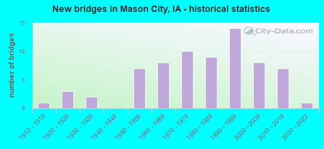
- New bridges - historical statistics
- 11910-1919
- 31920-1929
- 21930-1939
- 71950-1959
- 81960-1969
- 101970-1979
- 91980-1989
- 141990-1999
- 82000-2009
- 72010-2019
- 12020-2022
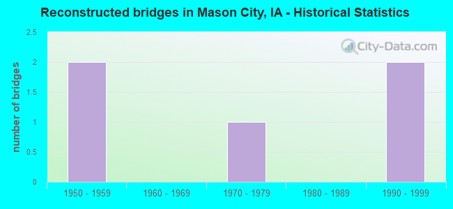
- Reconstructed bridges - Historical Statistics
- 21950-1959
- 01960-1969
- 11970-1979
- 01980-1989
- 21990-1999
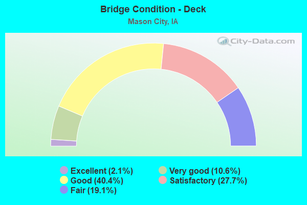
- Bridge Condition - Deck
- 2.1%Excellent
- 10.6%Very good
- 40.4%Good
- 27.7%Satisfactory
- 19.1%Fair

- Bridge Condition - Superstructure
- 2.1%Excellent
- 29.2%Very good
- 33.3%Good
- 20.8%Satisfactory
- 10.4%Fair
- 2.1%Poor
- 2.1%Serious
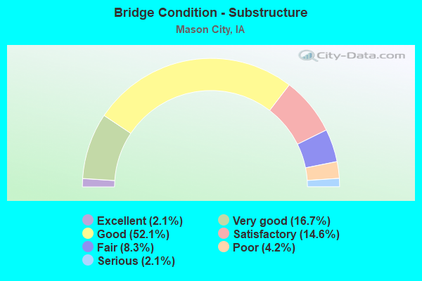
- Bridge Condition - Substructure
- 2.1%Excellent
- 16.7%Very good
- 52.1%Good
- 14.6%Satisfactory
- 8.3%Fair
- 4.2%Poor
- 2.1%Serious
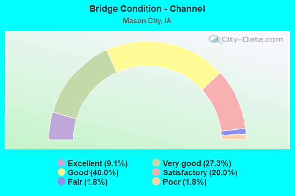
- Bridge Condition - Channel
- 9.1%Excellent
- 27.3%Very good
- 40.0%Good
- 20.0%Satisfactory
- 1.8%Fair
- 1.8%Poor
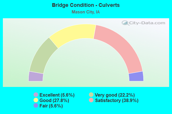
- Bridge Condition - Culverts
- 5.6%Excellent
- 22.2%Very good
- 27.8%Good
- 38.9%Satisfactory
- 5.6%Fair
Find on map >> Show street view
Structure Number: 106821, Location: 097211404 (Lat: 43.219744, Lng: -93.299942), Route carried "on" structure: County highway , Year Built: 1984, Status: Open, Structure Length: 6.86m (22.51ft), Average Daily Traffic: 440 (year 2021), Truck Traffic: 26%, Average Future Daily Traffic: 440 (year 2040), Design Load: H 20, Features Intersected: WINNEBAGO RIVER, Facility Carried by Structure: KILLDEER
Minimum Vertical Clearance: 30+ m (98+ ft), Kilometerpoint: 27.515, Lanes on structure: 2, Owner: County Highway Agency, Approaching Roadway Width: 9.1m (29.9ft), Skew: 4 degrees, Material/Design: Steel continuous, Design/Construction: Girder and Floorbeam System, Number Of Spans In Main Unit: 3, Length of Maximum Span: 26.8m (87.9ft), Curb-To-Curb Width: 8.5m (27.9ft), Out-to-Out Width: 10.4m (34.1ft)
Condition: Deck: Satisfactory, Superstructure: Good, Substructure: Good, Channel: Very good, Operating Rating: 39.1 metric tons, Method Used To Determine Operating Rating: Allowable Stress (AS), Inventory Rating: 21.7 metric tons, Method Used To Determine Inventory Rating: Allowable Stress (AS), Structural Evaluation: Equal to present minimum criteria, Deck Geometry: Somewhat better than minimum adequacy, Waterway Adequacy: Equal to present desirable criteria, Approach Roadway Alignment: Equal to present desirable criteria, Designated Inspection Frequency: Every 24 months, Inspection Date: January 2020, Deck Structure Type: Concrete Cast-file-Place, Wearing Surface/Protective System: Wearing Surface: Monolithic Concrete
Find on map >> Show street view
Structure Number: 10687, Location: 097212404 (Lat: 43.206417, Lng: -93.280303), Route carried "on" structure: County highway , Year Built: 1952, Status: Posted for load, Structure Length: 3.66m (12.01ft), Average Daily Traffic: 10 (year 2013), Average Future Daily Traffic: 10 (year 2040), Design Load: H 15, Features Intersected: WINNEBAGO RIVER, Facility Carried by Structure: WHEELERWOOD
Minimum Vertical Clearance: 30+ m (98+ ft), Kilometerpoint: 29.953, Lanes on structure: 2, Owner: County Highway Agency, Approaching Roadway Width: 9.8m (32.2ft), Skew: 4 degrees, Material/Design: Steel continuous, Design/Construction: Stringer/Multi-beam, Number Of Spans In Main Unit: 2, Length of Maximum Span: 18.3m (60.0ft), Curb-To-Curb Width: 6.1m (20.0ft), Out-to-Out Width: 6.5m (21.3ft)
Condition: Deck: Satisfactory, Superstructure: Good, Substructure: Fair, Channel: Satisfactory, Operating Rating: 34.7 metric tons, Method Used To Determine Operating Rating: Allowable Stress (AS), Inventory Rating: 21.2 metric tons, Method Used To Determine Inventory Rating: Allowable Stress (AS), Structural Evaluation: Somewhat better than minimum adequacy, Deck Geometry: Somewhat better than minimum adequacy, Waterway Adequacy: Equal to present desirable criteria, Approach Roadway Alignment: Better than present minimum criteria, Bridge Posting: Required (Relationship of Operating Rating to Maximum Legal Load: 0.1 - 9.9% below), Length Of Structure Improvement: 15.00m (49.21ft), Designated Inspection Frequency: Every 24 months, Inspection Date: January 2020, Bridge Improvement Cost: $333,000, Roadway Improvement Cost: $48,000, Deck Structure Type: Concrete Cast-file-Place, Wearing Surface/Protective System: Wearing Surface: Monolithic Concrete
Find on map >> Show street view
Structure Number: 106881, Location: 097212602 (Lat: 43.189361, Lng: -93.300208), Route carried "on" structure: County highway , Year Built: 1981, Status: Open, Structure Length: 1.19m (3.90ft), Average Daily Traffic: 640 (year 2021), Truck Traffic: 16%, Average Future Daily Traffic: 640 (year 2040), Design Load: HS 20, Features Intersected: CALMUS CREEK, Facility Carried by Structure: KILLDEER
Minimum Vertical Clearance: 30+ m (98+ ft), Kilometerpoint: 24.140, Lanes on structure: 2, Owner: County Highway Agency, Approaching Roadway Width: 9.8m (32.2ft), Material/Design: Concrete, Design/Construction: Culvert, Number Of Spans In Main Unit: 3, Length of Maximum Span: 3.7m (12.1ft)
Condition: Channel: Good, Culverts: Satisfactory, Operating Rating: 44.9 metric tons, Method Used To Determine Operating Rating: Field evaluation and documented engineering judgment, Inventory Rating: 32.3 metric tons, Method Used To Determine Inventory Rating: Field evaluation and documented engineering judgment, Structural Evaluation: Equal to present minimum criteria, Waterway Adequacy: Equal to present desirable criteria, Approach Roadway Alignment: Superior to present desirable criteria, Designated Inspection Frequency: Every 24 months, Inspection Date: January 2020
Find on map >> Show street view
Structure Number: 364705, Location: 097213603 (Lat: 43.176908, Lng: -93.260922), Route carried "on" structure: County highway , Year Built: 2003, Status: Open, Structure Length: 0.91m (2.99ft), Average Daily Traffic: 45 (year 2013), Average Future Daily Traffic: 45 (year 2040), Design Load: HS 20, Features Intersected: SMALL STREAM, Facility Carried by Structure: 285TH
Minimum Vertical Clearance: 30+ m (98+ ft), Kilometerpoint: 13.667, Lanes on structure: 2, Owner: County Highway Agency, Approaching Roadway Width: 7.3m (24.0ft), Skew: 3 degrees, Material/Design: Concrete, Design/Construction: Culvert, Number Of Spans In Main Unit: 2, Length of Maximum Span: 4.6m (15.1ft)
Condition: Channel: Very good, Culverts: Good, Operating Rating: 44.4 metric tons, Method Used To Determine Operating Rating: Field evaluation and documented engineering judgment, Inventory Rating: 32.7 metric tons, Method Used To Determine Inventory Rating: Field evaluation and documented engineering judgment, Structural Evaluation: Better than present minimum criteria, Waterway Adequacy: Equal to present desirable criteria, Approach Roadway Alignment: Equal to present desirable criteria, Designated Inspection Frequency: Every 24 months, Inspection Date: January 2020
Find on map >> Show street view
Structure Number: 366205, Location: 0.5 Mi W of US65 (Lat: 43.066697, Lng: -93.212514), Route carried "on" structure: County highway , Year Built: 2006, Status: Open, Structure Length: 0.67m (2.20ft), Average Daily Traffic: 420 (year 2021), Truck Traffic: 24%, Average Future Daily Traffic: 420 (year 2040), Design Load: HS 20, Features Intersected: E BR BEAVER DAM CREEK, Facility Carried by Structure: B43 210TH ST
Minimum Vertical Clearance: 30+ m (98+ ft), Kilometerpoint: 23.234, Lanes on structure: 2, Owner: County Highway Agency, Approaching Roadway Width: 9.1m (29.9ft), Material/Design: Concrete, Design/Construction: Culvert, Number Of Spans In Main Unit: 2, Length of Maximum Span: 3.0m (9.8ft)
Condition: Channel: Excellent, Culverts: Very good, Operating Rating: 45.4 metric tons, Method Used To Determine Operating Rating: Load Factor (LF), Inventory Rating: 32.7 metric tons, Method Used To Determine Inventory Rating: Load Factor (LF), Structural Evaluation: Equal to present desirable criteria, Waterway Adequacy: Better than present minimum criteria, Approach Roadway Alignment: Equal to present desirable criteria, Designated Inspection Frequency: Every 24 months, Inspection Date: Febuary 2020
Find on map >> Show street view
Structure Number: 366295, Location: 0.25 MI E S34 (Lat: 43.176903, Lng: -93.255292), Route carried "on" structure: County highway , Year Built: 2016, Status: Open, Structure Length: 0.80m (2.62ft), Average Daily Traffic: 130 (year 2013), Average Future Daily Traffic: 130 (year 2040), Design Load: HL 93, Features Intersected: SMALL STREAM, Facility Carried by Structure: 285TH ST
Minimum Vertical Clearance: 30+ m (98+ ft), Kilometerpoint: 14.124, Lanes on structure: 2, Owner: County Highway Agency, Approaching Roadway Width: 7.3m (24.0ft), Material/Design: Concrete, Design/Construction: Culvert, Number Of Spans In Main Unit: 2, Length of Maximum Span: 3.7m (12.1ft)
Condition: Channel: Very good, Culverts: Very good, Operating Rating: 42.1 metric tons, Method Used To Determine Operating Rating: Load and Resistance Factor Rating (LRFR) rating reported by rating factor(RF) method using HL-93 loadings, Inventory Rating: 32.4 metric tons, Method Used To Determine Inventory Rating: Load and Resistance Factor Rating (LRFR) rating reported by rating factor(RF) method using HL-93 loadings, Structural Evaluation: Equal to present desirable criteria, Waterway Adequacy: Equal to present desirable criteria, Approach Roadway Alignment: Equal to present desirable criteria, Designated Inspection Frequency: Every 24 months, Inspection Date: January 2020
Find on map >> Show street view
Structure Number: 50083, Location: 000000000 (Lat: 43.133872, Lng: -93.141864), Route carried "on" structure: City street , Year Built: 1928, Status: Open, Structure Length: 1.04m (3.41ft), Average Daily Traffic: 110 (year 2013), Average Future Daily Traffic: 110 (year 2042), Features Intersected: STREAM, Facility Carried by Structure: S BIRCH DR
Minimum Vertical Clearance: 30+ m (98+ ft), Kilometerpoint: 2.639, Lanes on structure: 1, Owner: City or Municipal Highway Agency, Approaching Roadway Width: 7.9m (25.9ft), Skew: 3 degrees, Material/Design: Steel, Design/Construction: Stringer/Multi-beam, Number Of Spans In Main Unit: 1, Length of Maximum Span: 10.1m (33.1ft), Curb-To-Curb Width: 5.4m (17.7ft), Out-to-Out Width: 6.7m (22.0ft)
Condition: Deck: Fair, Superstructure: Fair, Substructure: Satisfactory, Channel: Good, Operating Rating: 47.7 metric tons, Method Used To Determine Operating Rating: Allowable Stress (AS), Inventory Rating: 29.5 metric tons, Method Used To Determine Inventory Rating: Allowable Stress (AS), Structural Evaluation: Somewhat better than minimum adequacy, Deck Geometry: High priority of replacement, Waterway Adequacy: Equal to present desirable criteria, Approach Roadway Alignment: Better than present minimum criteria, Length Of Structure Improvement: 5.50m (18.04ft), Designated Inspection Frequency: Every 24 months, Inspection Date: January 2022, Bridge Improvement Cost: $154,000, Roadway Improvement Cost: $31,000, Deck Structure Type: Concrete Cast-file-Place, Wearing Surface/Protective System: Wearing Surface: Monolithic Concrete
Find on map >> Show street view
Structure Number: 50108, Location: 000000000 (Lat: 43.155297, Lng: -93.184639), Route carried "on" structure: City street , Year Built: 1961, Status: Open, Structure Length: 0.98m (3.22ft), Average Daily Traffic: 1,161 (year 2015), Average Future Daily Traffic: 1,161 (year 2042), Design Load: H 15, Features Intersected: WILLOW CREEK, Facility Carried by Structure: 4TH ST NE
Minimum Vertical Clearance: 30+ m (98+ ft), Kilometerpoint: 1.353, Lanes on structure: 2, Owner: City or Municipal Highway Agency, Approaching Roadway Width: 10.4m (34.1ft), Material/Design: Concrete, Design/Construction: Culvert, Number Of Spans In Main Unit: 3, Length of Maximum Span: 3.0m (9.8ft), Curb or Sidewalk Widths: Left: 1.5m (4.9ft), Right: 1.5m (4.9ft)
Condition: Channel: Very good, Culverts: Good, Operating Rating: 20.4 metric tons, Method Used To Determine Operating Rating: Field evaluation and documented engineering judgment, Inventory Rating: 16.3 metric tons, Method Used To Determine Inventory Rating: Field evaluation and documented engineering judgment, Structural Evaluation: Meets minimum limits, Waterway Adequacy: Equal to present desirable criteria, Approach Roadway Alignment: Better than present minimum criteria, Length Of Structure Improvement: 5.40m (17.72ft), Designated Inspection Frequency: Every 24 months, Inspection Date: January 2022, Bridge Improvement Cost: $119,000, Roadway Improvement Cost: $24,000
Find on map >> Show street view
Structure Number: 50265, Location: 000000000 (Lat: 43.137514, Lng: -93.223181), Route carried "on" structure: City street , Year Built: 1980, Status: Open, Structure Length: 2.16m (7.09ft), Average Daily Traffic: 2,570 (year 2021), Average Future Daily Traffic: 2,570 (year 2042), Design Load: HS 20, Features Intersected: CHESLEA CREEK, Facility Carried by Structure: 15TH ST SW
Minimum Vertical Clearance: 30+ m (98+ ft), Kilometerpoint: 1.830, Lanes on structure: 2, Owner: City or Municipal Highway Agency, Approaching Roadway Width: 9.1m (29.9ft), Material/Design: Prestressed concrete, Design/Construction: Stringer/Multi-beam, Number Of Spans In Main Unit: 1, Length of Maximum Span: 20.7m (67.9ft), Curb or Sidewalk Widths: Left: 2.4m (7.9ft), Right: 0.0m, Curb-To-Curb Width: 9.1m (29.9ft), Out-to-Out Width: 12.7m (41.7ft)
Condition: Deck: Satisfactory, Superstructure: Very good, Substructure: Very good, Channel: Very good, Operating Rating: 72.6 metric tons, Method Used To Determine Operating Rating: Allowable Stress (AS), Inventory Rating: 33.6 metric tons, Method Used To Determine Inventory Rating: Allowable Stress (AS), Structural Evaluation: Equal to present desirable criteria, Deck Geometry: Meets minimum limits, Waterway Adequacy: Equal to present desirable criteria, Approach Roadway Alignment: Equal to present desirable criteria, Length Of Structure Improvement: 9.70m (31.82ft), Designated Inspection Frequency: Every 24 months, Inspection Date: January 2022, Bridge Improvement Cost: $263,000, Roadway Improvement Cost: $53,000, Deck Structure Type: Concrete Cast-file-Place, Wearing Surface/Protective System: Wearing Surface: Monolithic Concrete
Find on map >> Show street view
Structure Number: 50389, Location: 000000000 (Lat: 43.130694, Lng: -93.230708), Route carried "on" structure: City street , Year Built: 1982, Status: Open, Structure Length: 2.07m (6.79ft), Average Daily Traffic: 150 (year 1989), Average Future Daily Traffic: 150 (year 2042), Design Load: HS 20, Features Intersected: CHESLEA CREEK, Facility Carried by Structure: BENJAMIN AVE
Minimum Vertical Clearance: 30+ m (98+ ft), Kilometerpoint: 0.455, Lanes on structure: 2, Owner: City or Municipal Highway Agency, Approaching Roadway Width: 11.0m (36.1ft), Skew: 1 degrees, Material/Design: Concrete continuous, Design/Construction: Slab, Number Of Spans In Main Unit: 3, Length of Maximum Span: 7.6m (24.9ft), Curb-To-Curb Width: 9.1m (29.9ft), Out-to-Out Width: 10.1m (33.1ft)
Condition: Deck: Good, Superstructure: Satisfactory, Substructure: Good, Channel: Good, Operating Rating: 60.4 metric tons, Method Used To Determine Operating Rating: Allowable Stress (AS), Inventory Rating: 37.4 metric tons, Method Used To Determine Inventory Rating: Allowable Stress (AS), Structural Evaluation: Equal to present minimum criteria, Deck Geometry: Equal to present minimum criteria, Waterway Adequacy: Equal to present desirable criteria, Approach Roadway Alignment: Equal to present desirable criteria, Designated Inspection Frequency: Every 24 months, Inspection Date: January 2022, Deck Structure Type: Concrete Cast-file-Place, Wearing Surface/Protective System: Wearing Surface: Monolithic Concrete
Find on map >> Show street view
Structure Number: 504081, Location: 000000000 (Lat: 43.127472, Lng: -93.233319), Route carried "on" structure: City street , Year Built: 1989, Status: Open, Structure Length: 2.53m (8.30ft), Average Daily Traffic: 805 (year 1998), Average Future Daily Traffic: 805 (year 2042), Design Load: HS 20, Features Intersected: CHESLEA CREEK, Facility Carried by Structure: 26TH ST. S.W.
Minimum Vertical Clearance: 30+ m (98+ ft), Kilometerpoint: 0.192, Lanes on structure: 2, Owner: City or Municipal Highway Agency, Approaching Roadway Width: 7.3m (24.0ft), Skew: 2 degrees, Material/Design: Concrete continuous, Design/Construction: Slab, Number Of Spans In Main Unit: 3, Length of Maximum Span: 9.4m (30.8ft), Curb-To-Curb Width: 9.1m (29.9ft), Out-to-Out Width: 10.1m (33.1ft)
Condition: Deck: Good, Superstructure: Good, Substructure: Satisfactory, Channel: Good, Operating Rating: 62.2 metric tons, Method Used To Determine Operating Rating: Allowable Stress (AS), Inventory Rating: 37.4 metric tons, Method Used To Determine Inventory Rating: Allowable Stress (AS), Structural Evaluation: Equal to present minimum criteria, Deck Geometry: Equal to present minimum criteria, Waterway Adequacy: Superior to present desirable criteria, Approach Roadway Alignment: Equal to present desirable criteria, Designated Inspection Frequency: Every 24 months, Inspection Date: January 2022, Deck Structure Type: Concrete Cast-file-Place, Wearing Surface/Protective System: Wearing Surface: Monolithic Concrete
Find on map >> Show street view
Structure Number: 50472, Location: 000000000 (Lat: 43.162767, Lng: -93.212717), Route carried "on" structure: City street , Year Built: 2005, Status: Open, Structure Length: 20.06m (65.81ft), Average Daily Traffic: 10,900 (year 2017), Average Future Daily Traffic: 10,900 (year 2042), Design Load: HS 20, Features Intersected: UP RR, Facility Carried by Structure: 12TH ST NW
Minimum Vertical Clearance: 30+ m (98+ ft), Kilometerpoint: 4.699, Lanes on structure: 2, Owner: City or Municipal Highway Agency, Approaching Roadway Width: 14.0m (45.9ft), Material/Design: Prestressed concrete, Design/Construction: Stringer/Multi-beam, Number Of Spans In Main Unit: 5, Length of Maximum Span: 40.2m (131.9ft), Curb or Sidewalk Widths: Left: 1.8m (5.9ft), Right: 0.0m, Curb-To-Curb Width: 14.0m (45.9ft), Out-to-Out Width: 17.1m (56.1ft)
Condition: Deck: Good, Superstructure: Very good, Substructure: Satisfactory, Operating Rating: 72.3 metric tons, Method Used To Determine Operating Rating: Load and Resistance Factor Rating (LRFR) rating reported by rating factor(RF) method using HL-93 loadings, Inventory Rating: 55.7 metric tons, Method Used To Determine Inventory Rating: Load and Resistance Factor Rating (LRFR) rating reported by rating factor(RF) method using HL-93 loadings, Structural Evaluation: Equal to present minimum criteria, Deck Geometry: Superior to present desirable criteria, Underclear: Superior to present desirable criteria, Approach Roadway Alignment: Equal to present desirable criteria, Designated Inspection Frequency: Every 24 months, Inspection Date: January 2022, Deck Structure Type: Concrete Cast-file-Place, Wearing Surface/Protective System: Wearing Surface: Monolithic Concrete
Find on map >> Show street view
Structure Number: 504945, Location: 000000000 (Lat: 43.133942, Lng: -93.219422), Route carried "on" structure: City street , Year Built: 2008, Status: Open, Structure Length: 18.53m (60.79ft), Average Daily Traffic: 7,000 (year 2013), Average Future Daily Traffic: 7,000 (year 2042), Design Load: HL 93, Features Intersected: UP RR & ARMORY RD, Facility Carried by Structure: 19TH STREET SW
Minimum Vertical Clearance: 30+ m (98+ ft), Kilometerpoint: 4.159, Lanes on structure: 2, Owner: City or Municipal Highway Agency, Approaching Roadway Width: 14.6m (47.9ft), Skew: 4 degrees, Material/Design: Prestressed concrete, Design/Construction: Stringer/Multi-beam, Number Of Spans In Main Unit: 3, Length of Maximum Span: 37.2m (122.0ft), Curb or Sidewalk Widths: Left: 1.8m (5.9ft), Right: 0.0m, Curb-To-Curb Width: 12.2m (40.0ft), Out-to-Out Width: 12.2m (40.0ft)
Condition: Deck: Good, Superstructure: Very good, Substructure: Very good, Operating Rating: 62.2 metric tons, Method Used To Determine Operating Rating: Load and Resistance Factor Rating (LRFR) rating reported by rating factor(RF) method using HL-93 loadings, Inventory Rating: 48.0 metric tons, Method Used To Determine Inventory Rating: Load and Resistance Factor Rating (LRFR) rating reported by rating factor(RF) method using HL-93 loadings, Structural Evaluation: Equal to present desirable criteria, Deck Geometry: Somewhat better than minimum adequacy, Approach Roadway Alignment: Equal to present desirable criteria, Designated Inspection Frequency: Every 24 months, Inspection Date: January 2022, Deck Structure Type: Concrete Cast-file-Place, Wearing Surface/Protective System: Wearing Surface: Monolithic Concrete
Find on map >> Show street view
Structure Number: 50545, Location: 0.1 mile East of Kentucky (Lat: 43.133536, Lng: -93.178975), Route carried "on" structure: City street , Year Built: 2016, Status: Open, Structure Length: 1.50m (4.92ft), Average Daily Traffic: 301 (year 2017), Average Future Daily Traffic: 301 (year 2042), Design Load: HL 93, Features Intersected: MASON CREEK, Facility Carried by Structure: 19TH ST SE
Minimum Vertical Clearance: 30+ m (98+ ft), Kilometerpoint: 1.799, Lanes on structure: 2, Owner: City or Municipal Highway Agency, Approaching Roadway Width: 11.9m (39.0ft), Skew: 1 degrees, Material/Design: Prestressed concrete, Design/Construction: Tee Beam, Number Of Spans In Main Unit: 1, Length of Maximum Span: 15.0m (49.2ft), Curb or Sidewalk Widths: Left: 1.6m (5.2ft), Right: 2.8m (9.2ft), Curb-To-Curb Width: 11.6m (38.1ft), Out-to-Out Width: 17.1m (56.1ft)
Condition: Deck: Very good, Superstructure: Very good, Substructure: Very good, Channel: Very good, Operating Rating: 42.8 metric tons, Method Used To Determine Operating Rating: Load and Resistance Factor Rating (LRFR) rating reported by rating factor(RF) method using HL-93 loadings, Inventory Rating: 33.0 metric tons, Method Used To Determine Inventory Rating: Load and Resistance Factor Rating (LRFR) rating reported by rating factor(RF) method using HL-93 loadings, Structural Evaluation: Equal to present desirable criteria, Deck Geometry: Superior to present desirable criteria, Waterway Adequacy: Superior to present desirable criteria, Approach Roadway Alignment: Equal to present desirable criteria, Designated Inspection Frequency: Every 24 months, Inspection Date: January 2022, Deck Structure Type: Concrete Precast Panels, Wearing Surface/Protective System: Wearing Surface: Integral Concrete
Find on map >> Show street view
Structure Number: 60192, Location: 1.5 mi. W of US 65 (Lat: 43.104911, Lng: -93.231767), Route carried "on" structure: US 18, Year Built: 1997, Status: Open, Structure Length: 6.64m (21.78ft), Average Daily Traffic: 4,300 (year 2020), Truck Traffic: 30%, Average Future Daily Traffic: 4,300 (year 2042), Design Load: HS 20, Features Intersected: UPRR
Minimum Vertical Clearance: 30+ m (98+ ft), Kilometerpoint: 297.508, Lanes on structure: 2, Base Highway Network: Yes, Owner: State Highway Agency, Approaching Roadway Width: 12.2m (40.0ft), Material/Design: Prestressed concrete, Design/Construction: Stringer/Multi-beam, Number Of Spans In Main Unit: 3, Length of Maximum Span: 30.8m (101.0ft), Curb-To-Curb Width: 12.0m (39.4ft), Out-to-Out Width: 13.0m (42.7ft)
Condition: Deck: Good, Superstructure: Good, Substructure: Good, Operating Rating: 75.3 metric tons, Method Used To Determine Operating Rating: Load Factor (LF), Inventory Rating: 45.3 metric tons, Method Used To Determine Inventory Rating: Load Factor (LF), Structural Evaluation: Better than present minimum criteria, Deck Geometry: Better than present minimum criteria, Underclear: Superior to present desirable criteria, Approach Roadway Alignment: Equal to present desirable criteria, Designated Inspection Frequency: Every 24 months, Inspection Date: Febuary 2022, Deck Structure Type: Concrete Cast-file-Place, Wearing Surface/Protective System: Wearing Surface: Monolithic Concrete, Deck Protection: Epoxy Coated Reinforcing
Find on map >> Show street view
Structure Number: 601925, Location: 1.5 mi. W of US 65 (Lat: 43.105103, Lng: -93.230931), Route carried "on" structure: US 18, Year Built: 1997, Status: Open, Structure Length: 6.55m (21.49ft), Average Daily Traffic: 4,300 (year 2020), Truck Traffic: 30%, Average Future Daily Traffic: 4,300 (year 2042), Design Load: HS 20, Features Intersected: UP RR
Minimum Vertical Clearance: 30+ m (98+ ft), Kilometerpoint: 203.811, Lanes on structure: 2, Owner: State Highway Agency, Approaching Roadway Width: 12.2m (40.0ft), Material/Design: Prestressed concrete, Design/Construction: Stringer/Multi-beam, Number Of Spans In Main Unit: 3, Length of Maximum Span: 30.8m (101.0ft), Curb-To-Curb Width: 12.0m (39.4ft), Out-to-Out Width: 13.0m (42.7ft)
Condition: Deck: Satisfactory, Superstructure: Good, Substructure: Good, Operating Rating: 75.1 metric tons, Method Used To Determine Operating Rating: Load Factor (LF), Inventory Rating: 45.1 metric tons, Method Used To Determine Inventory Rating: Load Factor (LF), Structural Evaluation: Better than present minimum criteria, Deck Geometry: Better than present minimum criteria, Underclear: Equal to present desirable criteria, Approach Roadway Alignment: Equal to present desirable criteria, Designated Inspection Frequency: Every 24 months, Inspection Date: Febuary 2022, Deck Structure Type: Concrete Cast-file-Place, Wearing Surface/Protective System: Wearing Surface: Monolithic Concrete, Deck Protection: Epoxy Coated Reinforcing
Find on map >> Show street view
Structure Number: 60193, Location: At Jct. US 18 (Lat: 43.104039, Lng: -93.201239), Route carried "on" structure: US 65, Year Built: 1996, Status: Open, Structure Length: 7.13m (23.39ft), Average Daily Traffic: 5,600 (year 2020), Truck Traffic: 10%, Average Future Daily Traffic: 5,600 (year 2040), Design Load: HS 20, Features Intersected: US 18
Minimum Vertical Clearance: 30+ m (98+ ft), Kilometerpoint: 311.505, Lanes on structure: 4, Lanes under structure: 4, Base Highway Network: Yes, Owner: State Highway Agency, Approaching Roadway Width: 19.5m (64.0ft), Skew: 20 degrees, Material/Design: Prestressed concrete, Design/Construction: Stringer/Multi-beam, Number Of Spans In Main Unit: 2, Length of Maximum Span: 35.4m (116.1ft), Curb-To-Curb Width: 27.3m (89.6ft), Out-to-Out Width: 28.4m (93.2ft)
Condition: Deck: Good, Superstructure: Good, Substructure: Good, Operating Rating: 76.6 metric tons, Method Used To Determine Operating Rating: Load Factor (LF), Inventory Rating: 43.7 metric tons, Method Used To Determine Inventory Rating: Load Factor (LF), Structural Evaluation: Better than present minimum criteria, Deck Geometry: Superior to present desirable criteria, Underclear: Somewhat better than minimum adequacy, Approach Roadway Alignment: Equal to present desirable criteria, Designated Inspection Frequency: Every 24 months, Inspection Date: August 2020, Deck Structure Type: Concrete Cast-file-Place, Wearing Surface/Protective System: Wearing Surface: Monolithic Concrete, Deck Protection: Epoxy Coated Reinforcing
Find on map >> Show street view
Structure Number: 60198, Location: 3.4 MI. E OF JCT. I-35 (Lat: 43.105117, Lng: -93.280522), Route carried "on" structure: County highway , Year Built: 1998, Status: Open, Structure Length: 6.86m (22.51ft), Average Daily Traffic: 1,040 (year 2021), Truck Traffic: 21%, Average Future Daily Traffic: 1,040 (year 2041), Design Load: HS 20, Features Intersected: US 18, Facility Carried by Structure: LARK AVE
Minimum Vertical Clearance: 30+ m (98+ ft), Kilometerpoint: 21.927, Lanes on structure: 2, Lanes under structure: 4, Owner: State Highway Agency, Approaching Roadway Width: 10.4m (34.1ft), Material/Design: Prestressed concrete, Design/Construction: Stringer/Multi-beam, Number Of Spans In Main Unit: 2, Length of Maximum Span: 33.8m (110.9ft), Curb-To-Curb Width: 9.0m (29.5ft), Out-to-Out Width: 10.0m (32.8ft)
Condition: Deck: Good, Superstructure: Very good, Substructure: Very good, Operating Rating: 89.8 metric tons, Method Used To Determine Operating Rating: Load Factor (LF), Inventory Rating: 59.6 metric tons, Method Used To Determine Inventory Rating: Load Factor (LF), Structural Evaluation: Equal to present desirable criteria, Deck Geometry: Somewhat better than minimum adequacy, Underclear: Equal to present minimum criteria, Approach Roadway Alignment: Equal to present desirable criteria, Designated Inspection Frequency: Every 24 months, Inspection Date: October 2021, Deck Structure Type: Concrete Cast-file-Place, Wearing Surface/Protective System: Wearing Surface: Monolithic Concrete, Deck Protection: Epoxy Coated Reinforcing
Find on map >> Show street view
Structure Number: 60646, Location: 1.6 mi. E of S.R. S56 (Lat: 43.119078, Lng: -93.092764), Route carried "on" structure: US 18, Year Built: 1997, Status: Open, Structure Length: 3.41m (11.19ft), Average Daily Traffic: 5,200 (year 2020), Truck Traffic: 27%, Average Future Daily Traffic: 5,200 (year 2040), Design Load: HS 20, Features Intersected: LITTLE LIME CREEK
Minimum Vertical Clearance: 30+ m (98+ ft), Kilometerpoint: 309.124, Lanes on structure: 2, Base Highway Network: Yes, Owner: State Highway Agency, Approaching Roadway Width: 14.0m (45.9ft), Material/Design: Concrete continuous, Design/Construction: Slab, Number Of Spans In Main Unit: 3, Length of Maximum Span: 13.1m (43.0ft), Curb-To-Curb Width: 12.0m (39.4ft), Out-to-Out Width: 13.0m (42.7ft)
Condition: Deck: Good, Superstructure: Good, Substructure: Good, Channel: Good, Operating Rating: 90.5 metric tons, Method Used To Determine Operating Rating: Load Factor (LF), Inventory Rating: 56.0 metric tons, Method Used To Determine Inventory Rating: Load Factor (LF), Structural Evaluation: Better than present minimum criteria, Deck Geometry: Better than present minimum criteria, Waterway Adequacy: Equal to present desirable criteria, Approach Roadway Alignment: Equal to present desirable criteria, Designated Inspection Frequency: Every 24 months, Inspection Date: March 2020, Deck Structure Type: Concrete Cast-file-Place, Wearing Surface/Protective System: Wearing Surface: Monolithic Concrete, Deck Protection: Epoxy Coated Reinforcing
Find on map >> Show street view
Structure Number: 606465, Location: 1.6 mi. E of S.R. S56 (Lat: 43.119328, Lng: -93.092364), Route carried "on" structure: US 18, Year Built: 1997, Status: Open, Structure Length: 3.41m (11.19ft), Average Daily Traffic: 5,200 (year 2020), Truck Traffic: 27%, Average Future Daily Traffic: 5,200 (year 2040), Design Load: HS 20, Features Intersected: LITTLE LIME CREEK
Minimum Vertical Clearance: 30+ m (98+ ft), Kilometerpoint: 192.228, Lanes on structure: 2, Owner: State Highway Agency, Approaching Roadway Width: 12.0m (39.4ft), Material/Design: Concrete continuous, Design/Construction: Slab, Number Of Spans In Main Unit: 3, Length of Maximum Span: 13.1m (43.0ft), Curb-To-Curb Width: 12.0m (39.4ft), Out-to-Out Width: 13.0m (42.7ft)
Condition: Deck: Satisfactory, Superstructure: Satisfactory, Substructure: Good, Channel: Good, Operating Rating: 90.5 metric tons, Method Used To Determine Operating Rating: Load Factor (LF), Inventory Rating: 55.3 metric tons, Method Used To Determine Inventory Rating: Load Factor (LF), Structural Evaluation: Equal to present minimum criteria, Deck Geometry: Better than present minimum criteria, Waterway Adequacy: Equal to present desirable criteria, Approach Roadway Alignment: Equal to present desirable criteria, Designated Inspection Frequency: Every 24 months, Inspection Date: March 2020, Deck Structure Type: Concrete Cast-file-Place, Wearing Surface/Protective System: Wearing Surface: Monolithic Concrete, Deck Protection: Epoxy Coated Reinforcing
Find on map >> Show street view
Structure Number: 60655, Location: 0.7 mi. E of Jct. U.S. 65 (Lat: 43.107061, Lng: -93.188319), Route carried "on" structure: US 18, Year Built: 1999, Status: Open, Structure Length: 5.30m (17.39ft), Average Daily Traffic: 5,000 (year 2020), Truck Traffic: 28%, Average Future Daily Traffic: 5,000 (year 2041), Design Load: HS 20, Features Intersected: UPRR
Minimum Vertical Clearance: 30+ m (98+ ft), Kilometerpoint: 200.299, Lanes on structure: 2, Owner: State Highway Agency, Approaching Roadway Width: 14.0m (45.9ft), Skew: 1 degrees, Material/Design: Prestressed concrete, Design/Construction: Stringer/Multi-beam, Number Of Spans In Main Unit: 3, Length of Maximum Span: 17.4m (57.1ft), Curb-To-Curb Width: 12.0m (39.4ft), Out-to-Out Width: 13.0m (42.7ft)
Condition: Deck: Good, Superstructure: Very good, Substructure: Good, Operating Rating: 71.4 metric tons, Method Used To Determine Operating Rating: Load Factor (LF), Inventory Rating: 48.2 metric tons, Method Used To Determine Inventory Rating: Load Factor (LF), Structural Evaluation: Better than present minimum criteria, Deck Geometry: Better than present minimum criteria, Underclear: Superior to present desirable criteria, Approach Roadway Alignment: Equal to present desirable criteria, Designated Inspection Frequency: Every 24 months, Inspection Date: October 2021, Deck Structure Type: Concrete Cast-file-Place, Wearing Surface/Protective System: Wearing Surface: Monolithic Concrete, Deck Protection: Epoxy Coated Reinforcing
Find on map >> Show street view
Structure Number: 606555, Location: 0.7 mi. E of Jct. US 65 (Lat: 43.106683, Lng: -93.188894), Route carried "on" structure: US 18, Year Built: 1999, Status: Open, Structure Length: 5.30m (17.39ft), Average Daily Traffic: 5,000 (year 2020), Truck Traffic: 28%, Average Future Daily Traffic: 5,000 (year 2041), Design Load: HS 20, Features Intersected: UPRR
Minimum Vertical Clearance: 30+ m (98+ ft), Kilometerpoint: 301.039, Lanes on structure: 2, Base Highway Network: Yes, Owner: State Highway Agency, Approaching Roadway Width: 14.0m (45.9ft), Skew: 1 degrees, Material/Design: Prestressed concrete, Design/Construction: Stringer/Multi-beam, Number Of Spans In Main Unit: 3, Length of Maximum Span: 17.4m (57.1ft), Curb-To-Curb Width: 12.0m (39.4ft), Out-to-Out Width: 13.0m (42.7ft)
Condition: Deck: Good, Superstructure: Very good, Substructure: Good, Operating Rating: 76.6 metric tons, Method Used To Determine Operating Rating: Load Factor (LF), Inventory Rating: 46.0 metric tons, Method Used To Determine Inventory Rating: Load Factor (LF), Structural Evaluation: Better than present minimum criteria, Deck Geometry: Better than present minimum criteria, Underclear: Superior to present desirable criteria, Approach Roadway Alignment: Equal to present desirable criteria, Designated Inspection Frequency: Every 24 months, Inspection Date: October 2021, Deck Structure Type: Concrete Cast-file-Place, Wearing Surface/Protective System: Wearing Surface: Low Slump Concrete, Deck Protection: Epoxy Coated Reinforcing
Find on map >> Show street view
Structure Number: 606565, Location: 5.0 mi. E of Jct. I-35 (Lat: 43.105503, Lng: -93.248233), Route carried "on" structure: US 18, Year Built: 1997, Status: Open, Structure Length: 5.30m (17.39ft), Average Daily Traffic: 4,300 (year 2020), Truck Traffic: 30%, Average Future Daily Traffic: 4,300 (year 2042), Design Load: HS 20, Features Intersected: CERRO GORDO COUNTY TRAIL
Minimum Vertical Clearance: 30+ m (98+ ft), Kilometerpoint: 205.220, Lanes on structure: 2, Owner: State Highway Agency, Approaching Roadway Width: 12.2m (40.0ft), Material/Design: Prestressed concrete, Design/Construction: Stringer/Multi-beam, Number Of Spans In Main Unit: 3, Length of Maximum Span: 17.7m (58.1ft), Curb-To-Curb Width: 12.0m (39.4ft), Out-to-Out Width: 13.0m (42.7ft)
Condition: Deck: Good, Superstructure: Good, Substructure: Good, Operating Rating: 72.0 metric tons, Method Used To Determine Operating Rating: Load Factor (LF), Inventory Rating: 43.3 metric tons, Method Used To Determine Inventory Rating: Load Factor (LF), Structural Evaluation: Better than present minimum criteria, Deck Geometry: Better than present minimum criteria, Approach Roadway Alignment: Equal to present desirable criteria, Designated Inspection Frequency: Every 24 months, Inspection Date: Febuary 2022, Deck Structure Type: Concrete Cast-file-Place, Wearing Surface/Protective System: Wearing Surface: Monolithic Concrete, Deck Protection: Epoxy Coated Reinforcing
Find on map >> Show street view
Structure Number: 60657, Location: 5.0 mi. E of Jct. I-35 (Lat: 43.105250, Lng: -93.248886), Route carried "on" structure: US 18, Year Built: 1997, Status: Open, Structure Length: 5.30m (17.39ft), Average Daily Traffic: 4,300 (year 2020), Truck Traffic: 30%, Average Future Daily Traffic: 4,300 (year 2042), Design Load: HS 20, Features Intersected: CERRO GORDO COUNTY TRAIL
Minimum Vertical Clearance: 30+ m (98+ ft), Kilometerpoint: 296.113, Lanes on structure: 2, Base Highway Network: Yes, Owner: State Highway Agency, Approaching Roadway Width: 12.2m (40.0ft), Material/Design: Prestressed concrete, Design/Construction: Stringer/Multi-beam, Number Of Spans In Main Unit: 3, Length of Maximum Span: 17.7m (58.1ft), Curb-To-Curb Width: 12.0m (39.4ft), Out-to-Out Width: 13.0m (42.7ft)
Condition: Deck: Satisfactory, Superstructure: Good, Substructure: Good, Operating Rating: 78.5 metric tons, Method Used To Determine Operating Rating: Load Factor (LF), Inventory Rating: 47.2 metric tons, Method Used To Determine Inventory Rating: Load Factor (LF), Structural Evaluation: Better than present minimum criteria, Deck Geometry: Better than present minimum criteria, Approach Roadway Alignment: Equal to present desirable criteria, Designated Inspection Frequency: Every 24 months, Inspection Date: Febuary 2022, Deck Structure Type: Concrete Cast-file-Place, Wearing Surface/Protective System: Wearing Surface: Monolithic Concrete, Deck Protection: Epoxy Coated Reinforcing
Find on map >> Show street view
Structure Number: 606655, Location: 4.4 mi. E of jct. I-35 (Lat: 43.105081, Lng: -93.260733), Route carried "on" structure: County highway , Year Built: 1998, Status: Open, Structure Length: 6.86m (22.51ft), Average Daily Traffic: 1,530 (year 2021), Truck Traffic: 15%, Average Future Daily Traffic: 1,530 (year 2041), Design Load: HS 20, Features Intersected: US 18, Facility Carried by Structure: MALLARD AVE
Minimum Vertical Clearance: 30+ m (98+ ft), Kilometerpoint: 18.734, Lanes on structure: 2, Lanes under structure: 4, Owner: State Highway Agency, Approaching Roadway Width: 12.8m (42.0ft), Material/Design: Prestressed concrete, Design/Construction: Stringer/Multi-beam, Number Of Spans In Main Unit: 2, Length of Maximum Span: 33.8m (110.9ft), Curb-To-Curb Width: 11.9m (39.0ft), Out-to-Out Width: 12.8m (42.0ft)
Condition: Deck: Good, Superstructure: Very good, Substructure: Good, Operating Rating: 88.3 metric tons, Method Used To Determine Operating Rating: Load Factor (LF), Inventory Rating: 53.0 metric tons, Method Used To Determine Inventory Rating: Load Factor (LF), Structural Evaluation: Better than present minimum criteria, Deck Geometry: Equal to present minimum criteria, Underclear: Meets minimum limits, Approach Roadway Alignment: Equal to present desirable criteria, Designated Inspection Frequency: Every 24 months, Inspection Date: August 2021, Deck Structure Type: Concrete Cast-file-Place, Wearing Surface/Protective System: Wearing Surface: Monolithic Concrete, Deck Protection: Epoxy Coated Reinforcing
Find on map >> Show street view
Structure Number: 504945, Location: 000000000 (Lat: 43.133942, Lng: -93.219422), Route carried "under" structure: State lands road , Year Built: 2008, Structure Length: 0. m, Features Intersected: UP RR & ARMORY RD, Facility Carried by Structure: 19TH STREET SW
Minimum Vertical Clearance: 30+ m (98+ ft), Kilometerpoint: 0.076, Lanes on structure: 2, Material/Design: Prestressed concrete, Design/Construction: Stringer/Multi-beam, Length of Maximum Span: 37.2m (122.0ft)
Find on map >> Show street view
Structure Number: 60193, Location: At Jct. US 18 (Lat: 43.104039, Lng: -93.201239), Route carried "under" structure: US 18, Year Built: 1996, Structure Length: 0. m, Average Daily Traffic: 7,500 (year 2020), Truck Traffic: 32%, Features Intersected: US 18, Facility Carried by Structure: US 65
Minimum Vertical Clearance: 30+ m (98+ ft), Kilometerpoint: 299.975, Lanes on structure: 4, Lanes under structure: 4, Material/Design: Prestressed concrete, Design/Construction: Stringer/Multi-beam, Length of Maximum Span: 35.4m (116.1ft)
Find on map >> Show street view
Structure Number: 60198, Location: 3.4 MI. E OF JCT. I-35 (Lat: 43.105117, Lng: -93.280522), Route carried "under" structure: US 18, Year Built: 1998, Structure Length: 0. m, Average Daily Traffic: 8,000 (year 2020), Truck Traffic: 32%, Features Intersected: US 18, Facility Carried by Structure: LARK AVE
Minimum Vertical Clearance: 30+ m (98+ ft), Kilometerpoint: 293.535, Lanes on structure: 2, Lanes under structure: 4, Material/Design: Prestressed concrete, Design/Construction: Stringer/Multi-beam, Length of Maximum Span: 33.8m (110.9ft)
Find on map >> Show street view
Structure Number: 606655, Location: 4.4 mi. E of jct. I-35 (Lat: 43.105081, Lng: -93.260733), Route carried "under" structure: US 18, Year Built: 1998, Structure Length: 0. m, Average Daily Traffic: 7,000 (year 2020), Truck Traffic: 33%, Features Intersected: US 18, Facility Carried by Structure: MALLARD AVE
Minimum Vertical Clearance: 30+ m (98+ ft), Kilometerpoint: 295.139, Lanes on structure: 2, Lanes under structure: 4, Material/Design: Prestressed concrete, Design/Construction: Stringer/Multi-beam, Length of Maximum Span: 33.8m (110.9ft)