Bridge Statistics for McPherson, Kansas (KS)
Condition, Traffic, Stress, Structural Evaluation, Project Costs
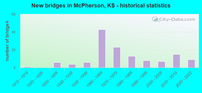
- New bridges - historical statistics
- 11910-1919
- 61930-1939
- 41940-1949
- 61950-1959
- 431960-1969
- 231970-1979
- 131980-1989
- 81990-1999
- 72000-2009
- 152010-2019
- 92020-2022
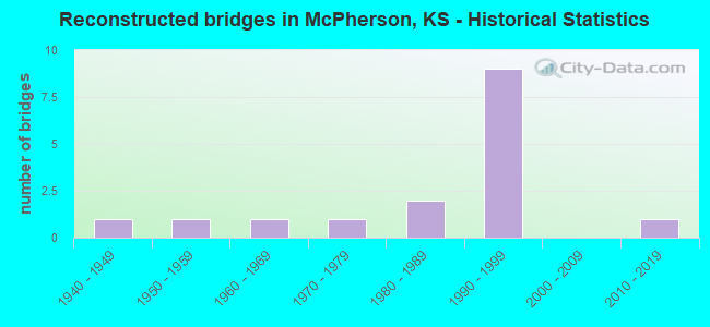
- Reconstructed bridges - Historical Statistics
- 11940-1949
- 11950-1959
- 11960-1969
- 11970-1979
- 21980-1989
- 91990-1999
- 02000-2009
- 12010-2019
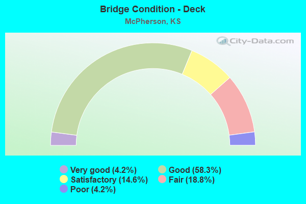
- Bridge Condition - Deck
- 4.2%Very good
- 58.3%Good
- 14.6%Satisfactory
- 18.8%Fair
- 4.2%Poor
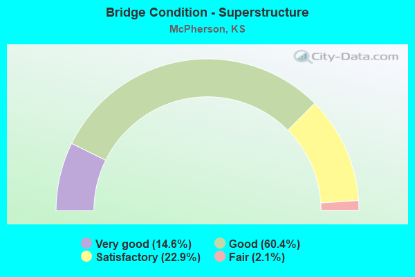
- Bridge Condition - Superstructure
- 14.6%Very good
- 60.4%Good
- 22.9%Satisfactory
- 2.1%Fair
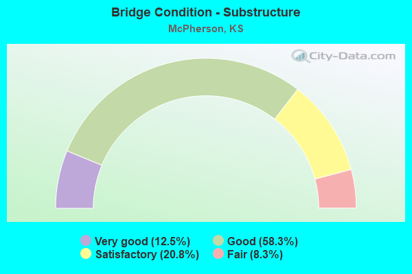
- Bridge Condition - Substructure
- 12.5%Very good
- 58.3%Good
- 20.8%Satisfactory
- 8.3%Fair
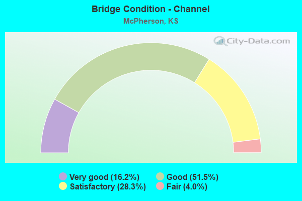
- Bridge Condition - Channel
- 16.2%Very good
- 51.5%Good
- 28.3%Satisfactory
- 4.0%Fair
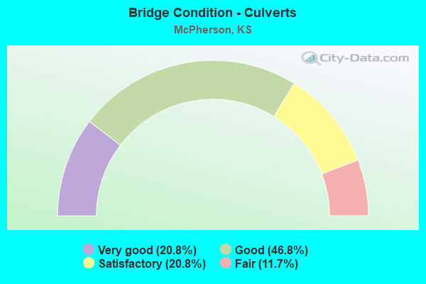
- Bridge Condition - Culverts
- 20.8%Very good
- 46.8%Good
- 20.8%Satisfactory
- 11.7%Fair
Find on map >> Show street view
Structure Number: 59015, Location: 1.8E 2.0N OF ELYRIA (Lat: 38.317728, Lng: -97.592772), Route carried "on" structure: County highway 319, Year Built: 1956, Status: Posted for load, Structure Length: 2.51m (8.23ft), Average Daily Traffic: 320 (year 2017), Truck Traffic: 12%, Average Future Daily Traffic: 480 (year 2040), Design Load: H 15, Features Intersected: TRIB. TO TURKEY CREEK
Minimum Vertical Clearance: 30.47m (99.97ft), Kilometerpoint: 0.000, Lanes on structure: 2, Owner: County Highway Agency, Approaching Roadway Width: 7.0m (23.0ft), Material/Design: Concrete, Design/Construction: Culvert, Number Of Spans In Main Unit: 4, Length of Maximum Span: 6.1m (20.0ft), Curb-To-Curb Width: 8.5m (27.9ft), Out-to-Out Width: 9.1m (29.9ft)
Condition: Channel: Satisfactory, Culverts: Good, Operating Rating: 24.5 metric tons, Method Used To Determine Operating Rating: Load Factor (LF), Inventory Rating: 14.6 metric tons, Method Used To Determine Inventory Rating: Load Factor (LF), Structural Evaluation: Meets minimum limits, Deck Geometry: Equal to present minimum criteria, Waterway Adequacy: Equal to present minimum criteria, Approach Roadway Alignment: Equal to present desirable criteria, Bridge Posting: Required (Relationship of Operating Rating to Maximum Legal Load: 10.0 - 19.9% below), Designated Inspection Frequency: Every 24 months, Inspection Date: January 2021
Find on map >> Show street view
Structure Number: 59016, Location: 3.9E 1.5S OF MCPHERSON (Lat: 38.347711, Lng: -97.594275), Route carried "on" structure: County highway 319, Year Built: 1954, Status: Open, Structure Length: 2.31m (7.58ft), Average Daily Traffic: 445 (year 2017), Truck Traffic: 12%, Average Future Daily Traffic: 650 (year 2040), Design Load: H 15, Features Intersected: TURKEY CREEK
Minimum Vertical Clearance: 30.47m (99.97ft), Kilometerpoint: 0.000, Lanes on structure: 2, Owner: County Highway Agency, Approaching Roadway Width: 7.0m (23.0ft), Material/Design: Concrete, Design/Construction: Culvert, Number Of Spans In Main Unit: 7, Length of Maximum Span: 3.0m (9.8ft), Out-to-Out Width: 9.1m (29.9ft)
Condition: Channel: Satisfactory, Culverts: Good, Operating Rating: 30.4 metric tons, Method Used To Determine Operating Rating: Load Factor (LF), Inventory Rating: 18.2 metric tons, Method Used To Determine Inventory Rating: Load Factor (LF), Structural Evaluation: Somewhat better than minimum adequacy, Waterway Adequacy: Equal to present minimum criteria, Approach Roadway Alignment: Somewhat better than minimum adequacy, Designated Inspection Frequency: Every 24 months, Inspection Date: Febuary 2021
Find on map >> Show street view
Structure Number: 590165, Location: 3.0E 1.1N OF MCPHERSON (Lat: 38.387272, Lng: -97.611328), Route carried "on" structure: County highway 319, Year Built: 1969, Status: Open, Structure Length: 0.65m (2.13ft), Average Daily Traffic: 1,000 (year 2017), Truck Traffic: 12%, Average Future Daily Traffic: 1,500 (year 2040), Design Load: H 15, Features Intersected: TRIB. DRY TURKEY CREEK
Minimum Vertical Clearance: 30.47m (99.97ft), Kilometerpoint: 0.000, Lanes on structure: 2, Owner: County Highway Agency, Approaching Roadway Width: 7.0m (23.0ft), Skew: 3 degrees, Material/Design: Concrete, Design/Construction: Culvert, Number Of Spans In Main Unit: 2, Length of Maximum Span: 3.2m (10.5ft), Curb-To-Curb Width: 8.5m (27.9ft), Out-to-Out Width: 9.1m (29.9ft)
Condition: Channel: Good, Culverts: Good, Operating Rating: 28.8 metric tons, Method Used To Determine Operating Rating: Load Factor (LF), Inventory Rating: 18.9 metric tons, Method Used To Determine Inventory Rating: Load Factor (LF), Structural Evaluation: Somewhat better than minimum adequacy, Deck Geometry: Somewhat better than minimum adequacy, Waterway Adequacy: Somewhat better than minimum adequacy, Approach Roadway Alignment: Equal to present desirable criteria, Designated Inspection Frequency: Every 24 months, Inspection Date: Febuary 2021
Find on map >> Show street view
Structure Number: 590167, Location: 3.0E 2.0N OF MCPHERSON (Lat: 38.397372, Lng: -97.611433), Route carried "on" structure: County highway 319, Year Built: 1969, Status: Posted for load, Structure Length: 0.65m (2.13ft), Average Daily Traffic: 290 (year 2017), Truck Traffic: 12%, Average Future Daily Traffic: 450 (year 2040), Design Load: H 15, Features Intersected: TRIB. DRY TURKEY CREEK
Minimum Vertical Clearance: 30.47m (99.97ft), Kilometerpoint: 0.000, Lanes on structure: 2, Owner: County Highway Agency, Approaching Roadway Width: 6.7m (22.0ft), Skew: 3 degrees, Material/Design: Concrete, Design/Construction: Culvert, Number Of Spans In Main Unit: 2, Length of Maximum Span: 3.2m (10.5ft), Out-to-Out Width: 9.1m (29.9ft)
Condition: Channel: Good, Culverts: Good, Operating Rating: 27.9 metric tons, Method Used To Determine Operating Rating: Load Factor (LF), Inventory Rating: 16.7 metric tons, Method Used To Determine Inventory Rating: Load Factor (LF), Structural Evaluation: Somewhat better than minimum adequacy, Waterway Adequacy: Equal to present minimum criteria, Approach Roadway Alignment: Equal to present desirable criteria, Bridge Posting: Required (Relationship of Operating Rating to Maximum Legal Load: 10.0 - 19.9% below), Designated Inspection Frequency: Every 24 months, Inspection Date: Febuary 2021
Find on map >> Show street view
Structure Number: 59017, Location: 3.0E 2.2N OF MCPHERSON (Lat: 38.402400, Lng: -97.611436), Route carried "on" structure: County highway 319, Year Built: 1969, Status: Open, Structure Length: 0.76m (2.49ft), Average Daily Traffic: 290 (year 2017), Truck Traffic: 12%, Average Future Daily Traffic: 450 (year 2040), Design Load: H 15, Features Intersected: TRIB. DRY TURKEY CREEK
Minimum Vertical Clearance: 30.47m (99.97ft), Kilometerpoint: 0.000, Lanes on structure: 2, Owner: County Highway Agency, Approaching Roadway Width: 7.0m (23.0ft), Material/Design: Concrete, Design/Construction: Culvert, Number Of Spans In Main Unit: 3, Length of Maximum Span: 2.4m (7.9ft), Out-to-Out Width: 9.1m (29.9ft)
Condition: Channel: Good, Culverts: Good, Operating Rating: 32.4 metric tons, Method Used To Determine Operating Rating: Load Factor (LF), Inventory Rating: 19.8 metric tons, Method Used To Determine Inventory Rating: Load Factor (LF), Structural Evaluation: Somewhat better than minimum adequacy, Waterway Adequacy: Equal to present minimum criteria, Approach Roadway Alignment: Equal to present desirable criteria, Designated Inspection Frequency: Every 24 months, Inspection Date: Febuary 2021
Find on map >> Show street view
Structure Number: 59037, Location: 3.4W OF ELYRIA (Lat: 38.289700, Lng: -97.689661), Route carried "on" structure: County highway 445, Year Built: 1966, Status: Posted for load, Structure Length: 1.10m (3.61ft), Average Daily Traffic: 420 (year 2017), Truck Traffic: 12%, Average Future Daily Traffic: 630 (year 2040), Design Load: H 15, Features Intersected: TRIB. DRY TURKEY CREEK
Minimum Vertical Clearance: 30.47m (99.97ft), Kilometerpoint: 0.000, Lanes on structure: 2, Owner: County Highway Agency, Approaching Roadway Width: 7.6m (24.9ft), Skew: 3 degrees, Material/Design: Concrete, Design/Construction: Culvert, Number Of Spans In Main Unit: 3, Length of Maximum Span: 3.5m (11.5ft)
Condition: Channel: Satisfactory, Culverts: Satisfactory, Operating Rating: 30.5 metric tons, Method Used To Determine Operating Rating: Load Factor (LF), Inventory Rating: 18.2 metric tons, Method Used To Determine Inventory Rating: Load Factor (LF), Structural Evaluation: Somewhat better than minimum adequacy, Waterway Adequacy: Equal to present minimum criteria, Approach Roadway Alignment: Equal to present desirable criteria, Bridge Posting: Required (Relationship of Operating Rating to Maximum Legal Load: 20.0 - 29.9% below), Designated Inspection Frequency: Every 24 months, Inspection Date: January 2021
Find on map >> Show street view
Structure Number: 59087, Location: 0.5N 2.6E OF MCPHERSON (Lat: 38.376753, Lng: -97.619739), Route carried "on" structure: County highway 1065, Year Built: 1968, Year Reconstructed: 1995, Status: Open, Structure Length: 0.67m (2.20ft), Average Daily Traffic: 2,240 (year 2017), Truck Traffic: 12%, Average Future Daily Traffic: 3,350 (year 2040), Design Load: H 20, Features Intersected: TRIB. DRY TURKEY CREEK
Minimum Vertical Clearance: 30.47m (99.97ft), Kilometerpoint: 0.000, Lanes on structure: 2, Owner: County Highway Agency, Approaching Roadway Width: 7.3m (24.0ft), Material/Design: Concrete, Design/Construction: Culvert, Number Of Spans In Main Unit: 3, Length of Maximum Span: 2.1m (6.9ft), Curb-To-Curb Width: 11.0m (36.1ft), Out-to-Out Width: 13.7m (44.9ft)
Condition: Channel: Satisfactory, Culverts: Good, Operating Rating: 24.6 metric tons, Method Used To Determine Operating Rating: Load Factor (LF), Inventory Rating: 14.7 metric tons, Method Used To Determine Inventory Rating: Load Factor (LF), Structural Evaluation: Meets minimum limits, Deck Geometry: Somewhat better than minimum adequacy, Waterway Adequacy: Equal to present minimum criteria, Approach Roadway Alignment: Equal to present desirable criteria, Designated Inspection Frequency: Every 24 months, Inspection Date: June 2021
Find on map >> Show street view
Structure Number: 59088, Location: 1.5N 1.4W OF MCPHERSON (Lat: 38.391181, Lng: -97.692278), Route carried "on" structure: County highway 1065, Year Built: 1936, Status: Posted for load, Structure Length: 1.07m (3.51ft), Average Daily Traffic: 175 (year 2017), Truck Traffic: 12%, Average Future Daily Traffic: 270 (year 2040), Features Intersected: BULL CREEK
Minimum Vertical Clearance: 30.47m (99.97ft), Kilometerpoint: 0.000, Lanes on structure: 2, Owner: County Highway Agency, Approaching Roadway Width: 7.0m (23.0ft), Material/Design: Concrete, Design/Construction: Culvert, Number Of Spans In Main Unit: 4, Length of Maximum Span: 2.4m (7.9ft), Curb-To-Curb Width: 8.4m (27.6ft), Out-to-Out Width: 9.0m (29.5ft)
Condition: Channel: Satisfactory, Culverts: Fair, Operating Rating: 35.1 metric tons, Method Used To Determine Operating Rating: Load Factor (LF), Inventory Rating: 20.7 metric tons, Method Used To Determine Inventory Rating: Load Factor (LF), Structural Evaluation: Somewhat better than minimum adequacy, Deck Geometry: Somewhat better than minimum adequacy, Waterway Adequacy: Equal to present minimum criteria, Approach Roadway Alignment: Equal to present desirable criteria, Designated Inspection Frequency: Every 24 months, Inspection Date: January 2021
Find on map >> Show street view
Structure Number: 59113, Location: 1.8NW OF ELYRIA (Lat: 38.312067, Lng: -97.646706), Route carried "on" structure: County highway 2043, Year Built: 1932, Year Reconstructed: 1946, Status: Open, Structure Length: 0.68m (2.23ft), Average Daily Traffic: 1,075 (year 2017), Truck Traffic: 12%, Average Future Daily Traffic: 1,600 (year 2040), Design Load: H 15, Features Intersected: TRIB. DRY TURKEY CREEK
Minimum Vertical Clearance: 30.47m (99.97ft), Kilometerpoint: 0.000, Lanes on structure: 2, Owner: County Highway Agency, Approaching Roadway Width: 7.9m (25.9ft), Material/Design: Concrete, Design/Construction: Culvert, Number Of Spans In Main Unit: 3, Length of Maximum Span: 2.1m (6.9ft), Out-to-Out Width: 12.9m (42.3ft)
Condition: Channel: Good, Culverts: Good, Operating Rating: 37.6 metric tons, Method Used To Determine Operating Rating: Load Factor (LF), Inventory Rating: 22.5 metric tons, Method Used To Determine Inventory Rating: Load Factor (LF), Structural Evaluation: Equal to present minimum criteria, Waterway Adequacy: Equal to present minimum criteria, Approach Roadway Alignment: Equal to present desirable criteria, Designated Inspection Frequency: Every 24 months, Inspection Date: March 2021
Find on map >> Show street view
Structure Number: 59114, Location: 2.7NW OF ELYRIA (Lat: 38.320494, Lng: -97.654647), Route carried "on" structure: County highway 2043, Year Built: 2000, Status: Open, Structure Length: 5.08m (16.67ft), Average Daily Traffic: 1,270 (year 2017), Truck Traffic: 12%, Average Future Daily Traffic: 1,900 (year 2040), Design Load: HS 20, Features Intersected: DRY TURKEY CREEK
Minimum Vertical Clearance: 30.47m (99.97ft), Kilometerpoint: 0.000, Lanes on structure: 2, Owner: County Highway Agency, Approaching Roadway Width: 8.5m (27.9ft), Material/Design: Concrete continuous, Design/Construction: Slab, Number Of Spans In Main Unit: 3, Length of Maximum Span: 20.0m (65.6ft), Curb-To-Curb Width: 11.0m (36.1ft), Out-to-Out Width: 11.6m (38.1ft)
Condition: Deck: Good, Superstructure: Good, Substructure: Good, Channel: Good, Operating Rating: 83.1 metric tons, Method Used To Determine Operating Rating: Load Factor (LF), Inventory Rating: 49.8 metric tons, Method Used To Determine Inventory Rating: Load Factor (LF), Structural Evaluation: Better than present minimum criteria, Deck Geometry: Equal to present minimum criteria, Waterway Adequacy: Better than present minimum criteria, Approach Roadway Alignment: Equal to present desirable criteria, Designated Inspection Frequency: Every 24 months, Inspection Date: January 2021, Deck Structure Type: Concrete Cast-file-Place, Wearing Surface/Protective System: Wearing Surface: Epoxy Overlay, Membrane: Epoxy, Deck Protection: Epoxy Coated Reinforcing
Find on map >> Show street view
Structure Number: 59075900494, Location: 2.6N 4.0W OF MARQUETTE (Lat: 38.596517, Lng: -97.906056), Route carried "on" structure: County highway 5926, Year Built: 1932, Year Reconstructed: 1960, Status: Posted for load, Structure Length: 0.79m (2.59ft), Average Daily Traffic: 65 (year 2017), Truck Traffic: 6%, Average Future Daily Traffic: 100 (year 2040), Features Intersected: TRIB. SMOKY HILL RIVER, Facility Carried by Structure: WHEATRIDGE RD.
Minimum Vertical Clearance: 30.47m (99.97ft), Kilometerpoint: 0.000, Lanes on structure: 2, Owner: County Highway Agency, Approaching Roadway Width: 6.4m (21.0ft), Skew: 1 degrees, Material/Design: Concrete, Design/Construction: Tee Beam, Number Of Spans In Main Unit: 1, Length of Maximum Span: 7.9m (25.9ft), Curb-To-Curb Width: 8.0m (26.2ft), Out-to-Out Width: 8.0m (26.2ft)
Condition: Deck: Good, Superstructure: Satisfactory, Substructure: Fair, Channel: Fair, Operating Rating: 9.1 metric tons, Method Used To Determine Operating Rating: Field evaluation and documented engineering judgment, Inventory Rating: 9.1 metric tons, Method Used To Determine Inventory Rating: Field evaluation and documented engineering judgment, Structural Evaluation: High priority of corrective action, Deck Geometry: Equal to present minimum criteria, Waterway Adequacy: Equal to present minimum criteria, Approach Roadway Alignment: Equal to present minimum criteria, Bridge Posting: Required (Relationship of Operating Rating to Maximum Legal Load: > 39.9% below), Length Of Structure Improvement: 1.22m (4.00ft), Designated Inspection Frequency: Every 24 months, Inspection Date: Febuary 2021, Bridge Improvement Cost: $130,000, Roadway Improvement Cost: $10,000, Total Project Cost: $155,000, Deck Structure Type: Concrete Cast-file-Place, Wearing Surface/Protective System: Wearing Surface: Bituminous
Find on map >> Show street view
Structure Number: 59075980548, Location: 2.0S. & 6.2W. OF INMAN (Lat: 38.202864, Lng: -97.889186), Route carried "on" structure: Other road , Year Built: 2012, Status: Open, Structure Length: 0.72m (2.36ft), Average Daily Traffic: 30 (year 2018), Truck Traffic: 6%, Average Future Daily Traffic: 30 (year 2037), Design Load: HS 20, Features Intersected: TRIB TO LITTLE ARKANSAS_, Facility Carried by Structure: ARROWHEAD RD.
Minimum Vertical Clearance: 30.47m (99.97ft), Kilometerpoint: 0.000, Lanes on structure: 2, Owner: County Highway Agency, Approaching Roadway Width: 6.7m (22.0ft), Skew: 3 degrees, Material/Design: Concrete, Design/Construction: Culvert, Number Of Spans In Main Unit: 2, Length of Maximum Span: 3.5m (11.5ft), Curb-To-Curb Width: 9.1m (29.9ft), Out-to-Out Width: 9.5m (31.2ft)
Condition: Channel: Good, Culverts: Good, Operating Rating: 60.7 metric tons, Method Used To Determine Operating Rating: Load Factor (LF), Inventory Rating: 36.4 metric tons, Method Used To Determine Inventory Rating: Load Factor (LF), Structural Evaluation: Better than present minimum criteria, Deck Geometry: Better than present minimum criteria, Waterway Adequacy: Equal to present minimum criteria, Approach Roadway Alignment: Equal to present desirable criteria, Designated Inspection Frequency: Every 24 months, Inspection Date: September 2020
Find on map >> Show street view
Structure Number: 590761005004, Location: 0.8S 3.0W OF MARQUETTE (Lat: 38.546700, Lng: -97.887511), Route carried "on" structure: County highway , Year Built: 1936, Status: Posted for load, Structure Length: 0.84m (2.76ft), Average Daily Traffic: 25 (year 2020), Truck Traffic: 2%, Average Future Daily Traffic: 35 (year 2040), Features Intersected: WOLF CREEK, Facility Carried by Structure: 2ND. AVE.
Minimum Vertical Clearance: 30.47m (99.97ft), Kilometerpoint: 0.000, Lanes on structure: 1, Owner: County Highway Agency, Approaching Roadway Width: 5.4m (17.7ft), Material/Design: Concrete, Design/Construction: Tee Beam, Number Of Spans In Main Unit: 1, Length of Maximum Span: 8.0m (26.2ft), Curb-To-Curb Width: 4.8m (15.7ft), Out-to-Out Width: 5.7m (18.7ft)
Condition: Deck: Satisfactory, Superstructure: Good, Substructure: Satisfactory, Channel: Good, Operating Rating: 22.5 metric tons, Method Used To Determine Operating Rating: No rating analysis performed, Inventory Rating: 13.5 metric tons, Method Used To Determine Inventory Rating: No rating analysis performed, Structural Evaluation: Meets minimum limits, Deck Geometry: Equal to present desirable criteria, Waterway Adequacy: Equal to present minimum criteria, Approach Roadway Alignment: Better than present minimum criteria, Length Of Structure Improvement: 0.91m (2.99ft), Designated Inspection Frequency: Every 24 months, Inspection Date: November 2020, Bridge Improvement Cost: $65,000, Roadway Improvement Cost: $10,000, Total Project Cost: $87,000, Deck Structure Type: Concrete Cast-file-Place, Wearing Surface/Protective System: Wearing Surface: Other
Find on map >> Show street view
Structure Number: 590761005469, Location: 6.0W & 1.9S OF INMAN (Lat: 38.203908, Lng: -97.885047), Route carried "on" structure: Other road , Year Built: 2012, Status: Open, Structure Length: 0.73m (2.40ft), Average Daily Traffic: 25 (year 2018), Truck Traffic: 6%, Average Future Daily Traffic: 30 (year 2037), Design Load: HS 20, Features Intersected: TRIB TO LITTLE ARKANSAS, Facility Carried by Structure: 2ND AVENUE
Minimum Vertical Clearance: 30.47m (99.97ft), Kilometerpoint: 0.000, Lanes on structure: 2, Owner: County Highway Agency, Approaching Roadway Width: 6.7m (22.0ft), Skew: 3 degrees, Material/Design: Concrete, Design/Construction: Culvert, Number Of Spans In Main Unit: 2, Length of Maximum Span: 3.5m (11.5ft), Curb-To-Curb Width: 9.1m (29.9ft), Out-to-Out Width: 9.5m (31.2ft)
Condition: Channel: Good, Culverts: Very good, Operating Rating: 60.8 metric tons, Method Used To Determine Operating Rating: Load Factor (LF), Inventory Rating: 36.5 metric tons, Method Used To Determine Inventory Rating: Load Factor (LF), Structural Evaluation: Equal to present desirable criteria, Deck Geometry: Better than present minimum criteria, Waterway Adequacy: Better than present minimum criteria, Approach Roadway Alignment: Equal to present desirable criteria, Designated Inspection Frequency: Every 24 months, Inspection Date: September 2020
Find on map >> Show street view
Structure Number: 5907770053, Location: 2.5S 4.1W OF MCPHERSON (Lat: 38.333164, Lng: -97.740611), Route carried "on" structure: County highway 5910, Year Built: 1987, Status: Open, Structure Length: 2.51m (8.23ft), Average Daily Traffic: 45 (year 2020), Truck Traffic: 6%, Average Future Daily Traffic: 53 (year 2040), Design Load: HS 20, Features Intersected: BLAZE FORK CREEK, Facility Carried by Structure: FRONTIER RD.
Minimum Vertical Clearance: 30.47m (99.97ft), Kilometerpoint: 0.000, Lanes on structure: 2, Owner: County Highway Agency, Approaching Roadway Width: 6.7m (22.0ft), Material/Design: Concrete continuous, Design/Construction: Slab, Number Of Spans In Main Unit: 3, Length of Maximum Span: 9.8m (32.2ft), Curb-To-Curb Width: 7.9m (25.9ft), Out-to-Out Width: 8.5m (27.9ft)
Condition: Deck: Good, Superstructure: Good, Substructure: Good, Channel: Satisfactory, Operating Rating: 68.4 metric tons, Method Used To Determine Operating Rating: Load Factor (LF), Inventory Rating: 41.4 metric tons, Method Used To Determine Inventory Rating: Load Factor (LF), Structural Evaluation: Better than present minimum criteria, Deck Geometry: Equal to present minimum criteria, Waterway Adequacy: Equal to present minimum criteria, Approach Roadway Alignment: Equal to present desirable criteria, Designated Inspection Frequency: Every 24 months, Inspection Date: December 2020, Deck Structure Type: Concrete Cast-file-Place
Find on map >> Show street view
Structure Number: 59077700532, Location: 3.5S 4.1W OF MCPHERSON (Lat: 38.318722, Lng: -97.740547), Route carried "on" structure: County highway , Year Built: 1987, Status: Open, Structure Length: 2.53m (8.30ft), Average Daily Traffic: 30 (year 2020), Truck Traffic: 6%, Average Future Daily Traffic: 43 (year 2040), Design Load: HS 20, Features Intersected: BLAZE FORK CREEK, Facility Carried by Structure: EISENHOWER RD.
Minimum Vertical Clearance: 30.47m (99.97ft), Kilometerpoint: 0.000, Lanes on structure: 2, Owner: County Highway Agency, Approaching Roadway Width: 6.7m (22.0ft), Material/Design: Concrete continuous, Design/Construction: Slab, Number Of Spans In Main Unit: 3, Length of Maximum Span: 9.8m (32.2ft), Curb-To-Curb Width: 7.9m (25.9ft), Out-to-Out Width: 8.5m (27.9ft)
Condition: Deck: Good, Superstructure: Good, Substructure: Good, Channel: Good, Operating Rating: 68.4 metric tons, Method Used To Determine Operating Rating: Load Factor (LF), Inventory Rating: 41.4 metric tons, Method Used To Determine Inventory Rating: Load Factor (LF), Structural Evaluation: Better than present minimum criteria, Deck Geometry: Equal to present minimum criteria, Waterway Adequacy: Equal to present minimum criteria, Approach Roadway Alignment: Equal to present desirable criteria, Designated Inspection Frequency: Every 24 months, Inspection Date: December 2020, Deck Structure Type: Concrete Cast-file-Place
Find on map >> Show street view
Structure Number: 59077730534, Location: 2.2E 5.0N OF INMAN (Lat: 38.304194, Lng: -97.734744), Route carried "on" structure: County highway , Year Built: 2009, Status: Open, Structure Length: 2.45m (8.04ft), Average Daily Traffic: 10 (year 2020), Truck Traffic: 6%, Average Future Daily Traffic: 20 (year 2040), Design Load: HS 20, Features Intersected: BLAZE FORK CREEK, Facility Carried by Structure: DAKOTA RD.
Minimum Vertical Clearance: 30.47m (99.97ft), Kilometerpoint: 0.000, Lanes on structure: 2, Owner: County Highway Agency, Approaching Roadway Width: 6.4m (21.0ft), Material/Design: Prestressed concrete, Design/Construction: Tee Beam, Number Of Spans In Main Unit: 1, Length of Maximum Span: 23.8m (78.1ft), Curb-To-Curb Width: 8.8m (28.9ft), Out-to-Out Width: 9.4m (30.8ft)
Condition: Deck: Very good, Superstructure: Very good, Substructure: Very good, Channel: Satisfactory, Operating Rating: 98.2 metric tons, Method Used To Determine Operating Rating: Load Factor (LF), Inventory Rating: 53.5 metric tons, Method Used To Determine Inventory Rating: Load Factor (LF), Structural Evaluation: Equal to present desirable criteria, Deck Geometry: Better than present minimum criteria, Waterway Adequacy: Somewhat better than minimum adequacy, Approach Roadway Alignment: Equal to present desirable criteria, Designated Inspection Frequency: Every 24 months, Inspection Date: July 2020, Deck Structure Type: Concrete Cast-file-Place, Wearing Surface/Protective System: Wearing Surface: Monolithic Concrete, Deck Protection: Epoxy Coated Reinforcing
Find on map >> Show street view
Structure Number: 59077790532, Location: 6.0N 2.9E OF INMAN (Lat: 38.318556, Lng: -97.724417), Route carried "on" structure: County highway , Year Built: 1998, Status: Open, Structure Length: 0.95m (3.12ft), Average Daily Traffic: 30 (year 2020), Truck Traffic: 6%, Average Future Daily Traffic: 34 (year 2040), Design Load: HS 20, Features Intersected: BLAZE FORK CREEK, Facility Carried by Structure: EISENHOWER RD.
Minimum Vertical Clearance: 30.47m (99.97ft), Kilometerpoint: 0.000, Lanes on structure: 2, Owner: County Highway Agency, Approaching Roadway Width: 6.7m (22.0ft), Material/Design: Concrete, Design/Construction: Culvert, Number Of Spans In Main Unit: 3, Length of Maximum Span: 3.0m (9.8ft), Curb-To-Curb Width: 10.4m (34.1ft), Out-to-Out Width: 10.8m (35.4ft)
Condition: Channel: Good, Culverts: Good, Operating Rating: 54.0 metric tons, Method Used To Determine Operating Rating: Load Factor (LF), Inventory Rating: 32.4 metric tons, Method Used To Determine Inventory Rating: Load Factor (LF), Structural Evaluation: Better than present minimum criteria, Deck Geometry: Superior to present desirable criteria, Waterway Adequacy: Somewhat better than minimum adequacy, Approach Roadway Alignment: Equal to present desirable criteria, Designated Inspection Frequency: Every 24 months, Inspection Date: December 2020
Find on map >> Show street view
Structure Number: 59077900546, Location: 0.9S 3.0E OF INMAN (Lat: 38.217464, Lng: -97.719917), Route carried "on" structure: County highway 5901, Year Built: 1964, Year Reconstructed: 1990, Status: Posted for load, Structure Length: 1.16m (3.81ft), Average Daily Traffic: 50 (year 2020), Truck Traffic: 6%, Average Future Daily Traffic: 60 (year 2040), Features Intersected: TRIB. TO BLAZE FORK CK., Facility Carried by Structure: 11TH. AVE.
Minimum Vertical Clearance: 30.47m (99.97ft), Kilometerpoint: 0.000, Lanes on structure: 2, Owner: County Highway Agency, Approaching Roadway Width: 6.0m (19.7ft), Material/Design: Wood or Timber, Design/Construction: Stringer/Multi-beam, Number Of Spans In Main Unit: 3, Length of Maximum Span: 5.8m (19.0ft), Curb-To-Curb Width: 6.0m (19.7ft), Out-to-Out Width: 6.1m (20.0ft)
Condition: Deck: Good, Superstructure: Good, Substructure: Fair, Channel: Satisfactory, Operating Rating: 24.4 metric tons, Method Used To Determine Operating Rating: Allowable Stress (AS), Inventory Rating: 18.1 metric tons, Method Used To Determine Inventory Rating: Allowable Stress (AS), Structural Evaluation: Somewhat better than minimum adequacy, Deck Geometry: Meets minimum limits, Waterway Adequacy: Somewhat better than minimum adequacy, Approach Roadway Alignment: Equal to present desirable criteria, Bridge Posting: Required (Relationship of Operating Rating to Maximum Legal Load: 20.0 - 29.9% below), Designated Inspection Frequency: Every 24 months, Inspection Date: January 2021, Deck Structure Type: Wood or Timber, Wearing Surface/Protective System: Wearing Surface: Other
Find on map >> Show street view
Structure Number: 59077990532, Location: 3.9E 6.0N OF INMAN (Lat: 38.318658, Lng: -97.706050), Route carried "on" structure: County highway , Year Built: 2011, Status: Open, Structure Length: 0.68m (2.23ft), Average Daily Traffic: 50 (year 2020), Truck Traffic: 6%, Average Future Daily Traffic: 75 (year 2040), Design Load: HS 20, Features Intersected: TRIB. TO TURKEY CREEK, Facility Carried by Structure: EISENHOWER RD.
Minimum Vertical Clearance: 30.47m (99.97ft), Kilometerpoint: 0.000, Lanes on structure: 2, Owner: County Highway Agency, Approaching Roadway Width: 8.5m (27.9ft), Skew: 2 degrees, Material/Design: Concrete, Design/Construction: Culvert, Number Of Spans In Main Unit: 3, Length of Maximum Span: 2.1m (6.9ft), Curb-To-Curb Width: 28.3m (92.8ft), Out-to-Out Width: 28.8m (94.5ft)
Condition: Channel: Very good, Culverts: Very good, Operating Rating: 80.2 metric tons, Method Used To Determine Operating Rating: Load Factor (LF), Inventory Rating: 48.1 metric tons, Method Used To Determine Inventory Rating: Load Factor (LF), Structural Evaluation: Equal to present desirable criteria, Deck Geometry: Superior to present desirable criteria, Waterway Adequacy: Equal to present minimum criteria, Approach Roadway Alignment: Equal to present desirable criteria, Length Of Structure Improvement: 0.68m (2.23ft), Designated Inspection Frequency: Every 24 months, Inspection Date: July 2020
Find on map >> Show street view
Structure Number: 590781005245, Location: 1.0W 0.5N OF MCPHERSON (Lat: 38.387583, Lng: -97.703350), Route carried "on" structure: County highway , Year Built: 1990, Status: Open, Structure Length: 0.62m (2.03ft), Average Daily Traffic: 25 (year 2020), Truck Traffic: 6%, Average Future Daily Traffic: 32 (year 2040), Design Load: HS 20, Features Intersected: TRIB. TO BULL CREEK, Facility Carried by Structure: 12TH. AVE.
Minimum Vertical Clearance: 30.47m (99.97ft), Kilometerpoint: 0.000, Lanes on structure: 2, Owner: County Highway Agency, Approaching Roadway Width: 4.2m (13.8ft), Material/Design: Concrete, Design/Construction: Culvert, Number Of Spans In Main Unit: 2, Length of Maximum Span: 3.0m (9.8ft), Curb or Sidewalk Widths: Left: 0.2m (0.7ft), Right: 0.2m (0.7ft), Curb-To-Curb Width: 7.9m (25.9ft), Out-to-Out Width: 8.4m (27.6ft)
Condition: Channel: Good, Culverts: Good, Operating Rating: 86.3 metric tons, Method Used To Determine Operating Rating: Load Factor (LF), Inventory Rating: 51.6 metric tons, Method Used To Determine Inventory Rating: Load Factor (LF), Structural Evaluation: Better than present minimum criteria, Deck Geometry: Equal to present minimum criteria, Waterway Adequacy: Equal to present minimum criteria, Approach Roadway Alignment: Equal to present desirable criteria, Designated Inspection Frequency: Every 24 months, Inspection Date: October 2020
Find on map >> Show street view
Structure Number: 590781005346, Location: 0.2N 1.3E OF GROVELAND (Lat: 38.296919, Lng: -97.703383), Route carried "on" structure: County highway , Year Built: 1987, Status: Open, Structure Length: 2.26m (7.41ft), Average Daily Traffic: 40 (year 2020), Truck Traffic: 6%, Average Future Daily Traffic: 53 (year 2040), Design Load: H 20, Features Intersected: TRIB. TO DRY TURKEY CK., Facility Carried by Structure: 12TH. AVE.
Minimum Vertical Clearance: 30.47m (99.97ft), Kilometerpoint: 0.000, Lanes on structure: 2, Owner: County Highway Agency, Approaching Roadway Width: 7.9m (25.9ft), Skew: 4 degrees, Material/Design: Concrete, Design/Construction: Culvert, Number Of Spans In Main Unit: 5, Length of Maximum Span: 4.3m (14.1ft)
Condition: Channel: Fair, Culverts: Satisfactory, Operating Rating: 32.7 metric tons, Method Used To Determine Operating Rating: Load Factor (LF), Inventory Rating: 19.6 metric tons, Method Used To Determine Inventory Rating: Load Factor (LF), Structural Evaluation: Somewhat better than minimum adequacy, Waterway Adequacy: Equal to present desirable criteria, Approach Roadway Alignment: Equal to present desirable criteria, Designated Inspection Frequency: Every 24 months, Inspection Date: January 2021
Find on map >> Show street view
Structure Number: 59078130518, Location: 3.5N 1.8W OF MCPHERSON (Lat: 38.420181, Lng: -97.697344), Route carried "on" structure: County highway , Year Built: 1976, Status: Open, Structure Length: 0.79m (2.59ft), Average Daily Traffic: 45 (year 2020), Truck Traffic: 6%, Average Future Daily Traffic: 53 (year 2037), Design Load: H 15, Features Intersected: BULL CREEK, Facility Carried by Structure: NAVAHO RD.
Minimum Vertical Clearance: 30.47m (99.97ft), Kilometerpoint: 0.000, Lanes on structure: 2, Owner: County Highway Agency, Approaching Roadway Width: 6.7m (22.0ft), Material/Design: Concrete, Design/Construction: Culvert, Number Of Spans In Main Unit: 3, Length of Maximum Span: 2.4m (7.9ft), Curb-To-Curb Width: 8.6m (28.2ft), Out-to-Out Width: 9.2m (30.2ft)
Condition: Channel: Satisfactory, Culverts: Good, Operating Rating: 37.8 metric tons, Method Used To Determine Operating Rating: No rating analysis performed, Inventory Rating: 22.5 metric tons, Method Used To Determine Inventory Rating: No rating analysis performed, Structural Evaluation: Equal to present minimum criteria, Deck Geometry: Better than present minimum criteria, Waterway Adequacy: Equal to present minimum criteria, Approach Roadway Alignment: Equal to present desirable criteria, Designated Inspection Frequency: Every 24 months, Inspection Date: October 2020
Find on map >> Show street view
Structure Number: 5907813052, Location: 2.5N 1.8W OF MCPHERSON (Lat: 38.405714, Lng: -97.698706), Route carried "on" structure: County highway , Year Built: 1993, Status: Open, Structure Length: 1.75m (5.74ft), Average Daily Traffic: 60 (year 2020), Truck Traffic: 6%, Average Future Daily Traffic: 92 (year 2037), Design Load: HS 20, Features Intersected: BULL CREEK, Facility Carried by Structure: MOHAWK RD.
Minimum Vertical Clearance: 30.47m (99.97ft), Kilometerpoint: 0.000, Lanes on structure: 2, Owner: County Highway Agency, Approaching Roadway Width: 6.7m (22.0ft), Material/Design: Concrete, Design/Construction: Culvert, Number Of Spans In Main Unit: 6, Length of Maximum Span: 2.7m (8.9ft), Curb-To-Curb Width: 7.9m (25.9ft), Out-to-Out Width: 8.4m (27.6ft)
Condition: Channel: Good, Culverts: Good, Operating Rating: 36.9 metric tons, Method Used To Determine Operating Rating: Load Factor (LF), Inventory Rating: 22.5 metric tons, Method Used To Determine Inventory Rating: Load Factor (LF), Structural Evaluation: Equal to present minimum criteria, Deck Geometry: Equal to present minimum criteria, Waterway Adequacy: Equal to present minimum criteria, Approach Roadway Alignment: Equal to present desirable criteria, Designated Inspection Frequency: Every 24 months, Inspection Date: October 2020
Find on map >> Show street view
Structure Number: 59078150518, Location: 3.5N 1.9W OF MCPHERSON (Lat: 38.420111, Lng: -97.694089), Route carried "on" structure: County highway , Year Built: 1976, Status: Open, Structure Length: 0.66m (2.17ft), Average Daily Traffic: 45 (year 2020), Truck Traffic: 6%, Average Future Daily Traffic: 54 (year 2037), Design Load: H 15, Features Intersected: TRIB. TO BULL CREEK, Facility Carried by Structure: NAVAHO RD.
Minimum Vertical Clearance: 30.47m (99.97ft), Kilometerpoint: 0.000, Lanes on structure: 2, Owner: County Highway Agency, Approaching Roadway Width: 6.7m (22.0ft), Skew: 3 degrees, Material/Design: Concrete, Design/Construction: Culvert, Number Of Spans In Main Unit: 2, Length of Maximum Span: 2.7m (8.9ft), Curb-To-Curb Width: 8.7m (28.5ft), Out-to-Out Width: 9.3m (30.5ft)
Condition: Channel: Good, Culverts: Satisfactory, Operating Rating: 37.8 metric tons, Method Used To Determine Operating Rating: Load Factor (LF), Inventory Rating: 22.5 metric tons, Method Used To Determine Inventory Rating: Load Factor (LF), Structural Evaluation: Equal to present minimum criteria, Deck Geometry: Better than present minimum criteria, Waterway Adequacy: Equal to present desirable criteria, Approach Roadway Alignment: Equal to present desirable criteria, Designated Inspection Frequency: Every 24 months, Inspection Date: October 2020
Find on map >> Show street view
Structure Number: 59078160524, Location: 1.5W OF MCPHERSON (Lat: 38.376761, Lng: -97.692375), Route carried "on" structure: County highway , Year Built: 1980, Status: Open, Structure Length: 2.92m (9.58ft), Average Daily Traffic: 50 (year 2020), Truck Traffic: 6%, Average Future Daily Traffic: 75 (year 2040), Design Load: H 20, Features Intersected: BULL CREEK, Facility Carried by Structure: LIMESTONE RD.
Minimum Vertical Clearance: 30.47m (99.97ft), Kilometerpoint: 0.000, Lanes on structure: 2, Owner: County Highway Agency, Approaching Roadway Width: 7.0m (23.0ft), Material/Design: Concrete, Design/Construction: Culvert, Number Of Spans In Main Unit: 9, Length of Maximum Span: 3.0m (9.8ft), Curb-To-Curb Width: 9.8m (32.2ft), Out-to-Out Width: 10.3m (33.8ft)
Condition: Channel: Good, Culverts: Good, Operating Rating: 36.9 metric tons, Method Used To Determine Operating Rating: Load Factor (LF), Inventory Rating: 22.5 metric tons, Method Used To Determine Inventory Rating: Load Factor (LF), Structural Evaluation: Equal to present minimum criteria, Deck Geometry: Equal to present desirable criteria, Waterway Adequacy: Equal to present desirable criteria, Approach Roadway Alignment: Equal to present desirable criteria, Designated Inspection Frequency: Every 24 months, Inspection Date: October 2020
Find on map >> Show street view
Structure Number: 590783005168, Location: 1.0W 2.2N OF MCPHERSON (Lat: 38.422975, Lng: -97.684694), Route carried "on" structure: County highway , Year Built: 1990, Status: Open, Structure Length: 0.76m (2.49ft), Average Daily Traffic: 30 (year 2020), Truck Traffic: 6%, Average Future Daily Traffic: 36 (year 2037), Design Load: HS 20, Features Intersected: TRIB. TO BULL CREEK, Facility Carried by Structure: 13TH. AVE.
Minimum Vertical Clearance: 30.47m (99.97ft), Kilometerpoint: 0.000, Lanes on structure: 2, Owner: County Highway Agency, Approaching Roadway Width: 6.7m (22.0ft), Material/Design: Concrete, Design/Construction: Culvert, Number Of Spans In Main Unit: 3, Length of Maximum Span: 2.4m (7.9ft), Curb-To-Curb Width: 7.9m (25.9ft), Out-to-Out Width: 8.4m (27.6ft)
Condition: Channel: Satisfactory, Culverts: Good, Operating Rating: 36.9 metric tons, Method Used To Determine Operating Rating: Load Factor (LF), Inventory Rating: 22.5 metric tons, Method Used To Determine Inventory Rating: Load Factor (LF), Structural Evaluation: Equal to present minimum criteria, Deck Geometry: Equal to present minimum criteria, Waterway Adequacy: Equal to present minimum criteria, Approach Roadway Alignment: Equal to present desirable criteria, Designated Inspection Frequency: Every 24 months, Inspection Date: October 2020
Find on map >> Show street view
Structure Number: 5907856053, Location: 2.5S 0.5E OF MCPHERSON (Lat: 38.333542, Lng: -97.655750), Route carried "on" structure: County highway , Year Built: 1955, Year Reconstructed: 1987, Status: Posted for load, Structure Length: 1.19m (3.90ft), Average Daily Traffic: 65 (year 2020), Truck Traffic: 6%, Average Future Daily Traffic: 80 (year 2040), Features Intersected: DRY TURKEY CREEK, Facility Carried by Structure: FRONTIER RD.
Minimum Vertical Clearance: 30.47m (99.97ft), Kilometerpoint: 0.000, Lanes on structure: 2, Owner: County Highway Agency, Approaching Roadway Width: 6.0m (19.7ft), Material/Design: Wood or Timber, Design/Construction: Stringer/Multi-beam, Number Of Spans In Main Unit: 2, Length of Maximum Span: 5.8m (19.0ft), Curb-To-Curb Width: 5.9m (19.4ft), Out-to-Out Width: 6.2m (20.3ft)
Condition: Deck: Satisfactory, Superstructure: Good, Substructure: Fair, Channel: Satisfactory, Operating Rating: 21.6 metric tons, Method Used To Determine Operating Rating: Load Factor (LF), Inventory Rating: 16.1 metric tons, Method Used To Determine Inventory Rating: Load Factor (LF), Structural Evaluation: Meets minimum limits, Deck Geometry: Meets minimum limits, Waterway Adequacy: Somewhat better than minimum adequacy, Approach Roadway Alignment: Better than present minimum criteria, Bridge Posting: Required (Relationship of Operating Rating to Maximum Legal Load: 0.1 - 9.9% below), Length Of Structure Improvement: 1.19m (3.90ft), Designated Inspection Frequency: Every 24 months, Inspection Date: October 2020, Bridge Improvement Cost: $45,000, Roadway Improvement Cost: $10,000, Total Project Cost: $65,000, Deck Structure Type: Wood or Timber, Wearing Surface/Protective System: Wearing Surface: Other
Find on map >> Show street view
Structure Number: 59078560532, Location: 0.5E 3.5S OF MCPHERSON (Lat: 38.318883, Lng: -97.655317), Route carried "on" structure: County highway , Year Built: 1972, Status: Open, Structure Length: 2.47m (8.10ft), Average Daily Traffic: 50 (year 2020), Truck Traffic: 6%, Average Future Daily Traffic: 60 (year 2040), Features Intersected: DRY TURKEY CREEK, Facility Carried by Structure: EISENHOWER RD.
Minimum Vertical Clearance: 30.47m (99.97ft), Kilometerpoint: 0.000, Lanes on structure: 2, Owner: County Highway Agency, Approaching Roadway Width: 6.4m (21.0ft), Material/Design: Prestressed concrete continuous, Design/Construction: Tee Beam, Number Of Spans In Main Unit: 2, Length of Maximum Span: 12.2m (40.0ft), Curb-To-Curb Width: 7.4m (24.3ft), Out-to-Out Width: 7.4m (24.3ft)
Condition: Deck: Good, Superstructure: Good, Substructure: Good, Channel: Good, Operating Rating: 26.1 metric tons, Method Used To Determine Operating Rating: Load Factor (LF), Inventory Rating: 15.3 metric tons, Method Used To Determine Inventory Rating: Load Factor (LF), Structural Evaluation: Meets minimum limits, Deck Geometry: Equal to present minimum criteria, Waterway Adequacy: Better than present minimum criteria, Approach Roadway Alignment: Equal to present desirable criteria, Designated Inspection Frequency: Every 24 months, Inspection Date: May 2021, Deck Structure Type: Other, Wearing Surface/Protective System: Wearing Surface: Other
Find on map >> Show street view
Structure Number: 59078580534, Location: 4.5S 0.8E OF MCPHERSON (Lat: 38.304306, Lng: -97.651783), Route carried "on" structure: County highway , Year Built: 1941, Year Reconstructed: 1986, Status: Posted for load, Structure Length: 1.77m (5.81ft), Average Daily Traffic: 30 (year 2020), Truck Traffic: 6%, Average Future Daily Traffic: 30 (year 2040), Features Intersected: DRY TURKEY CREEK, Facility Carried by Structure: DAKOTA RD.
Minimum Vertical Clearance: 30.47m (99.97ft), Kilometerpoint: 0.000, Lanes on structure: 2, Owner: County Highway Agency, Approaching Roadway Width: 6.7m (22.0ft), Material/Design: Wood or Timber, Design/Construction: Stringer/Multi-beam, Number Of Spans In Main Unit: 3, Length of Maximum Span: 5.9m (19.4ft), Curb-To-Curb Width: 7.2m (23.6ft), Out-to-Out Width: 7.4m (24.3ft)
Condition: Deck: Good, Superstructure: Satisfactory, Substructure: Satisfactory, Channel: Satisfactory, Operating Rating: 23.1 metric tons, Method Used To Determine Operating Rating: Allowable Stress (AS), Inventory Rating: 16.7 metric tons, Method Used To Determine Inventory Rating: Allowable Stress (AS), Structural Evaluation: Somewhat better than minimum adequacy, Deck Geometry: Somewhat better than minimum adequacy, Waterway Adequacy: Meets minimum limits, Approach Roadway Alignment: Better than present minimum criteria, Bridge Posting: Required (Relationship of Operating Rating to Maximum Legal Load: 0.1 - 9.9% below), Designated Inspection Frequency: Every 24 months, Inspection Date: January 2021, Deck Structure Type: Wood or Timber, Wearing Surface/Protective System: Wearing Surface: Other
Find on map >> Show street view
Structure Number: 59078590528, Location: 1.5S 0.9E OF MCPHERSON (Lat: 38.347708, Lng: -97.650044), Route carried "on" structure: County highway , Year Built: 1981, Status: Open, Structure Length: 2.64m (8.66ft), Average Daily Traffic: 300 (year 2020), Truck Traffic: 6%, Average Future Daily Traffic: 450 (year 2040), Design Load: H 20, Features Intersected: DRY TURKEY CREEK, Facility Carried by Structure: IRON HORSE RD.
Minimum Vertical Clearance: 30.47m (99.97ft), Kilometerpoint: 0.000, Lanes on structure: 2, Owner: County Highway Agency, Approaching Roadway Width: 7.3m (24.0ft), Material/Design: Concrete, Design/Construction: Culvert, Number Of Spans In Main Unit: 10, Length of Maximum Span: 2.4m (7.9ft), Out-to-Out Width: 9.8m (32.2ft)
Condition: Channel: Good, Culverts: Good, Operating Rating: 33.7 metric tons, Method Used To Determine Operating Rating: Load Factor (LF), Inventory Rating: 20.1 metric tons, Method Used To Determine Inventory Rating: Load Factor (LF), Structural Evaluation: Somewhat better than minimum adequacy, Waterway Adequacy: Meets minimum limits, Approach Roadway Alignment: Equal to present desirable criteria, Designated Inspection Frequency: Every 24 months, Inspection Date: Febuary 2021
Find on map >> Show street view
Structure Number: 590787005269, Location: 1.0E 0.9S OF MCPHERSON (Lat: 38.347917, Lng: -97.648144), Route carried "on" structure: County highway , Year Built: 1996, Status: Open, Structure Length: 1.29m (4.23ft), Average Daily Traffic: 300 (year 2020), Truck Traffic: 6%, Average Future Daily Traffic: 450 (year 2040), Design Load: HS 20, Features Intersected: TRIB. TO DRY TURKEY CK., Facility Carried by Structure: 15TH. AVE.
Minimum Vertical Clearance: 30.47m (99.97ft), Kilometerpoint: 0.000, Lanes on structure: 2, Owner: County Highway Agency, Approaching Roadway Width: 7.0m (23.0ft), Material/Design: Concrete, Design/Construction: Culvert, Number Of Spans In Main Unit: 4, Length of Maximum Span: 3.0m (9.8ft), Curb-To-Curb Width: 10.5m (34.4ft), Out-to-Out Width: 11.0m (36.1ft)
Condition: Channel: Good, Culverts: Good, Operating Rating: 76.7 metric tons, Method Used To Determine Operating Rating: Load Factor (LF), Inventory Rating: 46.1 metric tons, Method Used To Determine Inventory Rating: Load Factor (LF), Structural Evaluation: Better than present minimum criteria, Deck Geometry: Better than present minimum criteria, Waterway Adequacy: Equal to present minimum criteria, Approach Roadway Alignment: Equal to present desirable criteria, Designated Inspection Frequency: Every 24 months, Inspection Date: Febuary 2021
Find on map >> Show street view
Structure Number: 590787005326, Location: 4.0S 1.0E OF MCPHERSON (Lat: 38.310708, Lng: -97.648611), Route carried "on" structure: County highway , Year Built: 1984, Status: Open, Structure Length: 1.10m (3.61ft), Average Daily Traffic: 50 (year 2020), Truck Traffic: 6%, Average Future Daily Traffic: 63 (year 2040), Design Load: H 20, Features Intersected: TRIB. TO DRY TURKEY CK., Facility Carried by Structure: 15TH. AVE.
Minimum Vertical Clearance: 30.47m (99.97ft), Kilometerpoint: 0.000, Lanes on structure: 2, Owner: County Highway Agency, Approaching Roadway Width: 6.7m (22.0ft), Skew: 3 degrees, Material/Design: Concrete, Design/Construction: Culvert, Number Of Spans In Main Unit: 3, Length of Maximum Span: 3.5m (11.5ft), Curb-To-Curb Width: 7.9m (25.9ft), Out-to-Out Width: 8.5m (27.9ft)
Condition: Channel: Satisfactory, Culverts: Satisfactory, Operating Rating: 36.0 metric tons, Method Used To Determine Operating Rating: Load Factor (LF), Inventory Rating: 21.6 metric tons, Method Used To Determine Inventory Rating: Load Factor (LF), Structural Evaluation: Equal to present minimum criteria, Deck Geometry: Equal to present minimum criteria, Waterway Adequacy: Better than present minimum criteria, Approach Roadway Alignment: Equal to present desirable criteria, Designated Inspection Frequency: Every 24 months, Inspection Date: January 2021, Other Special Inspection Date: July 2021
Find on map >> Show street view
Structure Number: 5907871052, Location: 1.0 N 1.1 E of McPherson (Lat: 38.405675, Lng: -97.646103), Route carried "on" structure: County highway , Year Built: 2003, Status: Open, Structure Length: 1.78m (5.84ft), Average Daily Traffic: 60 (year 2020), Truck Traffic: 6%, Average Future Daily Traffic: 90 (year 2040), Design Load: HS 20, Features Intersected: Dry Turkey Creek, Facility Carried by Structure: Mohawk Road
Minimum Vertical Clearance: 30.47m (99.97ft), Kilometerpoint: 0.000, Lanes on structure: 2, Owner: County Highway Agency, Approaching Roadway Width: 7.3m (24.0ft), Skew: 3 degrees, Material/Design: Concrete, Design/Construction: Culvert, Number Of Spans In Main Unit: 4, Length of Maximum Span: 4.2m (13.8ft)
Condition: Channel: Good, Culverts: Good, Operating Rating: 87.4 metric tons, Method Used To Determine Operating Rating: Load Factor (LF), Inventory Rating: 52.3 metric tons, Method Used To Determine Inventory Rating: Load Factor (LF), Structural Evaluation: Better than present minimum criteria, Waterway Adequacy: Equal to present minimum criteria, Approach Roadway Alignment: Equal to present desirable criteria, Length Of Structure Improvement: 1.83m (6.00ft), Designated Inspection Frequency: Every 24 months, Inspection Date: Febuary 2021, Other Special Inspection Date: July 2021
Find on map >> Show street view
Structure Number: 59078710522, Location: N.E. COR. OF MCPHERSON (Lat: 38.391150, Lng: -97.646836), Route carried "on" structure: County highway , Year Built: 1978, Status: Open, Structure Length: 3.26m (10.70ft), Average Daily Traffic: 3,635 (year 2017), Truck Traffic: 6%, Average Future Daily Traffic: 5,450 (year 2040), Design Load: H 20, Features Intersected: DRY TURKEY CREEK, Facility Carried by Structure: MOCCASIN RD.
Minimum Vertical Clearance: 30.47m (99.97ft), Kilometerpoint: 0.000, Lanes on structure: 2, Owner: County Highway Agency, Approaching Roadway Width: 7.3m (24.0ft), Material/Design: Concrete, Design/Construction: Culvert, Number Of Spans In Main Unit: 10, Length of Maximum Span: 3.0m (9.8ft), Curb-To-Curb Width: 12.3m (40.4ft), Out-to-Out Width: 12.7m (41.7ft)
Condition: Channel: Satisfactory, Culverts: Satisfactory, Operating Rating: 35.1 metric tons, Method Used To Determine Operating Rating: Load Factor (LF), Inventory Rating: 21.0 metric tons, Method Used To Determine Inventory Rating: Load Factor (LF), Structural Evaluation: Somewhat better than minimum adequacy, Deck Geometry: Equal to present minimum criteria, Waterway Adequacy: Equal to present desirable criteria, Approach Roadway Alignment: Equal to present desirable criteria, Designated Inspection Frequency: Every 24 months, Inspection Date: June 2021
Find on map >> Show street view
Structure Number: 59078780518, Location: 2.0N 1.5E OF MCPHERSON (Lat: 38.420194, Lng: -97.634469), Route carried "on" structure: County highway , Year Built: 1988, Status: Posted for load, Structure Length: 1.33m (4.36ft), Average Daily Traffic: 50 (year 2020), Truck Traffic: 6%, Average Future Daily Traffic: 61 (year 2040), Design Load: HS 20, Features Intersected: DRY TURKEY CREEK, Facility Carried by Structure: NAVAHO RD.
Minimum Vertical Clearance: 30.47m (99.97ft), Kilometerpoint: 0.000, Lanes on structure: 2, Owner: County Highway Agency, Approaching Roadway Width: 7.3m (24.0ft), Material/Design: Concrete, Design/Construction: Culvert, Number Of Spans In Main Unit: 3, Length of Maximum Span: 4.3m (14.1ft), Curb-To-Curb Width: 7.9m (25.9ft), Out-to-Out Width: 8.4m (27.6ft)
Condition: Channel: Good, Culverts: Good, Operating Rating: 29.6 metric tons, Method Used To Determine Operating Rating: Load Factor (LF), Inventory Rating: 17.7 metric tons, Method Used To Determine Inventory Rating: Load Factor (LF), Structural Evaluation: Somewhat better than minimum adequacy, Deck Geometry: Equal to present minimum criteria, Waterway Adequacy: Equal to present minimum criteria, Approach Roadway Alignment: Equal to present desirable criteria, Bridge Posting: Required (Relationship of Operating Rating to Maximum Legal Load: 30.0 - 39.9% below), Designated Inspection Frequency: Every 24 months, Inspection Date: Febuary 2021
Find on map >> Show street view
Structure Number: 59078780526, Location: 0.5S 1.7E OF MCPHERSON (Lat: 38.362197, Lng: -97.634219), Route carried "on" structure: County highway , Year Built: 1968, Status: Open, Structure Length: 1.62m (5.31ft), Average Daily Traffic: 3,940 (year 2017), Truck Traffic: 6%, Average Future Daily Traffic: 5,900 (year 2040), Features Intersected: TRIB. TO DRY TURKEY CK., Facility Carried by Structure: KIOWA RD.
Minimum Vertical Clearance: 30.47m (99.97ft), Kilometerpoint: 0.000, Lanes on structure: 2, Owner: County Highway Agency, Approaching Roadway Width: 7.0m (23.0ft), Material/Design: Steel continuous, Design/Construction: Stringer/Multi-beam, Number Of Spans In Main Unit: 2, Length of Maximum Span: 7.9m (25.9ft), Curb-To-Curb Width: 9.8m (32.2ft), Out-to-Out Width: 10.5m (34.4ft)
Condition: Deck: Satisfactory, Superstructure: Fair, Substructure: Satisfactory, Channel: Good, Operating Rating: 36.5 metric tons, Method Used To Determine Operating Rating: Load Factor (LF), Inventory Rating: 21.8 metric tons, Method Used To Determine Inventory Rating: Load Factor (LF), Structural Evaluation: Somewhat better than minimum adequacy, Deck Geometry: Meets minimum limits, Waterway Adequacy: Equal to present minimum criteria, Approach Roadway Alignment: Equal to present desirable criteria, Designated Inspection Frequency: Every 24 months, Inspection Date: June 2021, Deck Structure Type: Concrete Cast-file-Place, Wearing Surface/Protective System: Wearing Surface: Bituminous
Find on map >> Show street view
Structure Number: 590789005161, Location: 4.4N 2.0E OF MCPHERSON (Lat: 38.433917, Lng: -97.629847), Route carried "on" structure: County highway , Year Built: 2008, Status: Open, Structure Length: 1.29m (4.23ft), Average Daily Traffic: 60 (year 2020), Truck Traffic: 6%, Average Future Daily Traffic: 78 (year 2040), Design Load: HS 20, Features Intersected: DRY TURKEY CREEK, Facility Carried by Structure: 16TH. AVE.
Minimum Vertical Clearance: 30.47m (99.97ft), Kilometerpoint: 0.000, Lanes on structure: 2, Owner: County Highway Agency, Approaching Roadway Width: 6.4m (21.0ft), Skew: 3 degrees, Material/Design: Concrete, Design/Construction: Culvert, Number Of Spans In Main Unit: 2, Length of Maximum Span: 6.3m (20.7ft), Out-to-Out Width: 8.4m (27.6ft)
Condition: Channel: Good, Culverts: Good, Operating Rating: 60.7 metric tons, Method Used To Determine Operating Rating: Load Factor (LF), Inventory Rating: 36.4 metric tons, Method Used To Determine Inventory Rating: Load Factor (LF), Structural Evaluation: Better than present minimum criteria, Waterway Adequacy: Equal to present minimum criteria, Approach Roadway Alignment: Equal to present desirable criteria, Length Of Structure Improvement: 1.34m (4.40ft), Designated Inspection Frequency: Every 24 months, Inspection Date: Febuary 2021, Wearing Surface/Protective System: Wearing Surface: Gravel
Find on map >> Show street view
Structure Number: 590789005224, Location: 1.0S 2.0E OF MCPHERSON (Lat: 38.386331, Lng: -97.629672), Route carried "on" structure: County highway , Year Built: 1974, Status: Open, Structure Length: 1.64m (5.38ft), Average Daily Traffic: 5,020 (year 2017), Truck Traffic: 6%, Average Future Daily Traffic: 7,530 (year 2040), Design Load: H 15, Features Intersected: TRIB. TO DRY TURKEY CK., Facility Carried by Structure: 16TH. AVE.
Minimum Vertical Clearance: 30.47m (99.97ft), Kilometerpoint: 0.000, Lanes on structure: 2, Owner: County Highway Agency, Approaching Roadway Width: 7.9m (25.9ft), Skew: 4 degrees, Material/Design: Concrete, Design/Construction: Culvert, Number Of Spans In Main Unit: 4, Length of Maximum Span: 3.9m (12.8ft), Curb-To-Curb Width: 12.1m (39.7ft), Out-to-Out Width: 12.7m (41.7ft)
Condition: Channel: Good, Culverts: Satisfactory, Operating Rating: 36.7 metric tons, Method Used To Determine Operating Rating: Load Factor (LF), Inventory Rating: 22.0 metric tons, Method Used To Determine Inventory Rating: Load Factor (LF), Structural Evaluation: Somewhat better than minimum adequacy, Deck Geometry: Somewhat better than minimum adequacy, Waterway Adequacy: Equal to present minimum criteria, Approach Roadway Alignment: Equal to present desirable criteria, Designated Inspection Frequency: Every 24 months, Inspection Date: June 2021
Find on map >> Show street view
Structure Number: 5907890053, Location: 2.0M S 1.9E OF MCPHERSON (Lat: 38.333139, Lng: -97.630583), Route carried "on" structure: County highway , Year Built: 1988, Status: Open, Structure Length: 0.76m (2.49ft), Average Daily Traffic: 30 (year 2020), Truck Traffic: 6%, Average Future Daily Traffic: 35 (year 2037), Design Load: HS 20, Features Intersected: TRIB. TO DRY TURKEY CRK., Facility Carried by Structure: 16 AVE. & FRONTIER
Minimum Vertical Clearance: 30.47m (99.97ft), Kilometerpoint: 0.000, Lanes on structure: 2, Owner: County Highway Agency, Approaching Roadway Width: 6.7m (22.0ft), Material/Design: Concrete, Design/Construction: Culvert, Number Of Spans In Main Unit: 3, Length of Maximum Span: 2.4m (7.9ft)
Condition: Channel: Fair, Culverts: Good, Operating Rating: 48.1 metric tons, Method Used To Determine Operating Rating: Load Factor (LF), Inventory Rating: 28.8 metric tons, Method Used To Determine Inventory Rating: Load Factor (LF), Structural Evaluation: Better than present minimum criteria, Waterway Adequacy: Somewhat better than minimum adequacy, Approach Roadway Alignment: Equal to present minimum criteria, Designated Inspection Frequency: Every 24 months, Inspection Date: October 2020
Find on map >> Show street view
Structure Number: 590789005344, Location: 0.6N OF ELYRIA (Lat: 38.298875, Lng: -97.629944), Route carried "on" structure: County highway , Year Built: 2002, Status: Open, Structure Length: 0.73m (2.40ft), Average Daily Traffic: 30 (year 2020), Truck Traffic: 6%, Average Future Daily Traffic: 35 (year 2040), Design Load: H 20, Features Intersected: TRIB. TO DRY TURKEY CK., Facility Carried by Structure: 16th AVENUE
Minimum Vertical Clearance: 30.47m (99.97ft), Kilometerpoint: 0.000, Lanes on structure: 2, Owner: County Highway Agency, Approaching Roadway Width: 6.7m (22.0ft), Skew: 3 degrees, Material/Design: Concrete, Design/Construction: Culvert, Number Of Spans In Main Unit: 2, Length of Maximum Span: 3.5m (11.5ft)
Condition: Channel: Satisfactory, Culverts: Good, Operating Rating: 57.8 metric tons, Method Used To Determine Operating Rating: Load Factor (LF), Inventory Rating: 34.6 metric tons, Method Used To Determine Inventory Rating: Load Factor (LF), Structural Evaluation: Better than present minimum criteria, Waterway Adequacy: Equal to present minimum criteria, Approach Roadway Alignment: Equal to present desirable criteria, Designated Inspection Frequency: Every 24 months, Inspection Date: January 2021, Other Special Inspection Date: July 2021
Find on map >> Show street view
Structure Number: 59078910534, Location: 2.1E 4.5S OF MCPHERSON (Lat: 38.304150, Lng: -97.628536), Route carried "on" structure: County highway , Year Built: 1976, Status: Open, Structure Length: 0.67m (2.20ft), Average Daily Traffic: 30 (year 2020), Truck Traffic: 6%, Average Future Daily Traffic: 35 (year 2040), Design Load: H 15, Features Intersected: TRIB. TO DRY TURKEY CK., Facility Carried by Structure: DAKOTA RD.
Minimum Vertical Clearance: 30.47m (99.97ft), Kilometerpoint: 0.000, Lanes on structure: 2, Owner: County Highway Agency, Approaching Roadway Width: 6.7m (22.0ft), Material/Design: Concrete, Design/Construction: Culvert, Number Of Spans In Main Unit: 3, Length of Maximum Span: 2.1m (6.9ft), Curb-To-Curb Width: 8.6m (28.2ft), Out-to-Out Width: 9.2m (30.2ft)
Condition: Channel: Good, Culverts: Good, Operating Rating: 42.3 metric tons, Method Used To Determine Operating Rating: Load Factor (LF), Inventory Rating: 25.2 metric tons, Method Used To Determine Inventory Rating: Load Factor (LF), Structural Evaluation: Equal to present minimum criteria, Deck Geometry: Better than present minimum criteria, Waterway Adequacy: Equal to present minimum criteria, Approach Roadway Alignment: Better than present minimum criteria, Designated Inspection Frequency: Every 24 months, Inspection Date: January 2021
Find on map >> Show street view
Structure Number: 59078920522, Location: 1.5N 2.1E OF MCPHERSON (Lat: 38.391231, Lng: -97.627111), Route carried "on" structure: County highway , Year Built: 1972, Year Reconstructed: 1990, Status: Open, Structure Length: 0.76m (2.49ft), Average Daily Traffic: 1,370 (year 2017), Truck Traffic: 6%, Average Future Daily Traffic: 2,050 (year 2040), Design Load: H 15, Features Intersected: TRIB. TO DRY TURKEY CK., Facility Carried by Structure: MOCCASIN RD.
Minimum Vertical Clearance: 30.47m (99.97ft), Kilometerpoint: 0.000, Lanes on structure: 2, Owner: County Highway Agency, Approaching Roadway Width: 7.3m (24.0ft), Material/Design: Concrete, Design/Construction: Culvert, Number Of Spans In Main Unit: 3, Length of Maximum Span: 2.4m (7.9ft), Curb or Sidewalk Widths: Left: 0.2m (0.7ft), Right: 0.2m (0.7ft), Curb-To-Curb Width: 15.3m (50.2ft), Out-to-Out Width: 15.8m (51.8ft)
Condition: Channel: Satisfactory, Culverts: Satisfactory, Operating Rating: 28.4 metric tons, Method Used To Determine Operating Rating: Load Factor (LF), Inventory Rating: 17.0 metric tons, Method Used To Determine Inventory Rating: Load Factor (LF), Structural Evaluation: Meets minimum limits, Deck Geometry: Superior to present desirable criteria, Waterway Adequacy: Equal to present minimum criteria, Approach Roadway Alignment: Equal to present desirable criteria, Designated Inspection Frequency: Every 24 months, Inspection Date: June 2021
Find on map >> Show street view
Structure Number: 59079150532, Location: 3.0S 3.5E OF MCPHERSON (Lat: 38.318536, Lng: -97.601481), Route carried "on" structure: County highway , Year Built: 1996, Status: Open, Structure Length: 1.29m (4.23ft), Average Daily Traffic: 40 (year 2020), Truck Traffic: 6%, Average Future Daily Traffic: 45 (year 2040), Design Load: HS 20, Features Intersected: TURKEY CREEK, Facility Carried by Structure: EISENHOWER ROAD
Minimum Vertical Clearance: 30.47m (99.97ft), Kilometerpoint: 0.000, Lanes on structure: 2, Owner: County Highway Agency, Approaching Roadway Width: 6.7m (22.0ft), Material/Design: Concrete, Design/Construction: Culvert, Number Of Spans In Main Unit: 4, Length of Maximum Span: 3.0m (9.8ft), Curb-To-Curb Width: 7.9m (25.9ft), Out-to-Out Width: 8.4m (27.6ft)
Condition: Channel: Good, Culverts: Good, Operating Rating: 76.5 metric tons, Method Used To Determine Operating Rating: Load Factor (LF), Inventory Rating: 45.9 metric tons, Method Used To Determine Inventory Rating: Load Factor (LF), Structural Evaluation: Better than present minimum criteria, Deck Geometry: Equal to present minimum criteria, Waterway Adequacy: Equal to present minimum criteria, Approach Roadway Alignment: Equal to present desirable criteria, Designated Inspection Frequency: Every 24 months, Inspection Date: January 2021
Find on map >> Show street view
Structure Number: 5907917053, Location: 3.7E 2.5S OF MCPHERSON (Lat: 38.333011, Lng: -97.599383), Route carried "on" structure: County highway , Year Built: 1955, Status: Posted for load, Structure Length: 1.20m (3.94ft), Average Daily Traffic: 25 (year 2020), Truck Traffic: 6%, Average Future Daily Traffic: 35 (year 2040), Features Intersected: TURKEY CREEK, Facility Carried by Structure: FRONTIER RD.
Minimum Vertical Clearance: 30.47m (99.97ft), Kilometerpoint: 0.000, Lanes on structure: 2, Owner: County Highway Agency, Approaching Roadway Width: 6.4m (21.0ft), Material/Design: Wood or Timber, Design/Construction: Stringer/Multi-beam, Number Of Spans In Main Unit: 2, Length of Maximum Span: 5.8m (19.0ft), Curb-To-Curb Width: 5.9m (19.4ft), Out-to-Out Width: 6.1m (20.0ft)
Condition: Deck: Satisfactory, Superstructure: Satisfactory, Substructure: Fair, Channel: Satisfactory, Operating Rating: 16.3 metric tons, Method Used To Determine Operating Rating: Allowable Stress (AS), Inventory Rating: 12.0 metric tons, Method Used To Determine Inventory Rating: Allowable Stress (AS), Structural Evaluation: Meets minimum limits, Deck Geometry: Meets minimum limits, Waterway Adequacy: Equal to present minimum criteria, Approach Roadway Alignment: Equal to present desirable criteria, Bridge Posting: Required (Relationship of Operating Rating to Maximum Legal Load: 30.0 - 39.9% below), Length Of Structure Improvement: 1.52m (4.99ft), Designated Inspection Frequency: Every 24 months, Inspection Date: Febuary 2021, Bridge Improvement Cost: $80,000, Roadway Improvement Cost: $10,000, Total Project Cost: $100,000, Deck Structure Type: Wood or Timber, Wearing Surface/Protective System: Wearing Surface: Other