Bridge Statistics for McPherson, Kansas (KS)
Condition, Traffic, Stress, Structural Evaluation, Project Costs
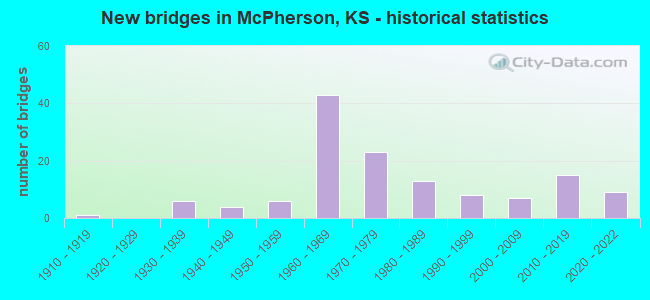
- New bridges - historical statistics
- 11910-1919
- 61930-1939
- 41940-1949
- 61950-1959
- 431960-1969
- 231970-1979
- 131980-1989
- 81990-1999
- 72000-2009
- 152010-2019
- 92020-2022
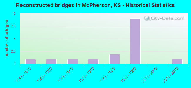
- Reconstructed bridges - Historical Statistics
- 11940-1949
- 11950-1959
- 11960-1969
- 11970-1979
- 21980-1989
- 91990-1999
- 02000-2009
- 12010-2019
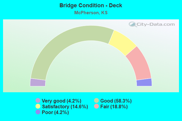
- Bridge Condition - Deck
- 4.2%Very good
- 58.3%Good
- 14.6%Satisfactory
- 18.8%Fair
- 4.2%Poor
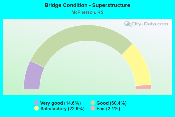
- Bridge Condition - Superstructure
- 14.6%Very good
- 60.4%Good
- 22.9%Satisfactory
- 2.1%Fair
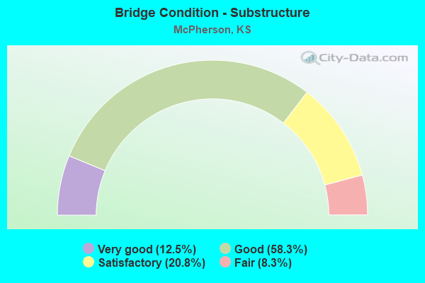
- Bridge Condition - Substructure
- 12.5%Very good
- 58.3%Good
- 20.8%Satisfactory
- 8.3%Fair
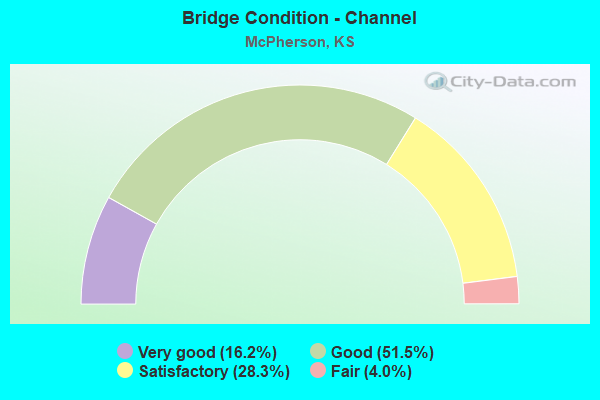
- Bridge Condition - Channel
- 16.2%Very good
- 51.5%Good
- 28.3%Satisfactory
- 4.0%Fair
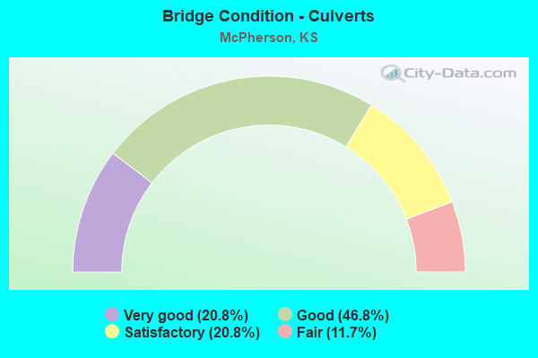
- Bridge Condition - Culverts
- 20.8%Very good
- 46.8%Good
- 20.8%Satisfactory
- 11.7%Fair
Find on map >> Show street view
Structure Number: 59079310526, Location: 4.1E 0.5S OF MCPHERSON (Lat: 38.362214, Lng: -97.592272), Route carried "on" structure: County highway , Year Built: 1987, Status: Open, Structure Length: 2.82m (9.25ft), Average Daily Traffic: 40 (year 2020), Truck Traffic: 6%, Average Future Daily Traffic: 49 (year 2040), Design Load: HS 20, Features Intersected: TURKEY CREEK, Facility Carried by Structure: KIOWA RD.
Minimum Vertical Clearance: 30.47m (99.97ft), Kilometerpoint: 0.000, Lanes on structure: 2, Owner: County Highway Agency, Approaching Roadway Width: 6.7m (22.0ft), Material/Design: Concrete continuous, Design/Construction: Slab, Number Of Spans In Main Unit: 3, Length of Maximum Span: 11.0m (36.1ft), Curb-To-Curb Width: 7.9m (25.9ft), Out-to-Out Width: 8.5m (27.9ft)
Condition: Deck: Good, Superstructure: Good, Substructure: Satisfactory, Channel: Satisfactory, Operating Rating: 82.8 metric tons, Method Used To Determine Operating Rating: Load Factor (LF), Inventory Rating: 49.5 metric tons, Method Used To Determine Inventory Rating: Load Factor (LF), Structural Evaluation: Equal to present minimum criteria, Deck Geometry: Equal to present minimum criteria, Waterway Adequacy: Better than present minimum criteria, Approach Roadway Alignment: Equal to present desirable criteria, Designated Inspection Frequency: Every 24 months, Inspection Date: Febuary 2021, Deck Structure Type: Concrete Cast-file-Place, Wearing Surface/Protective System: Wearing Surface: Gravel
Find on map >> Show street view
Structure Number: 59079310532, Location: 3.5S 4.1E OF MCPHERSON (Lat: 38.318708, Lng: -97.592183), Route carried "on" structure: County highway , Year Built: 1956, Status: Posted for load, Structure Length: 2.51m (8.23ft), Average Daily Traffic: 40 (year 2020), Truck Traffic: 6%, Average Future Daily Traffic: 49 (year 2040), Design Load: H 15, Features Intersected: TRIB. TO TURKEY CREEK, Facility Carried by Structure: EISENHOWER RD.
Minimum Vertical Clearance: 30.47m (99.97ft), Kilometerpoint: 0.000, Lanes on structure: 2, Owner: County Highway Agency, Approaching Roadway Width: 6.7m (22.0ft), Material/Design: Concrete, Design/Construction: Culvert, Number Of Spans In Main Unit: 4, Length of Maximum Span: 6.1m (20.0ft), Curb-To-Curb Width: 7.3m (24.0ft), Out-to-Out Width: 7.9m (25.9ft)
Condition: Channel: Good, Culverts: Good, Operating Rating: 14.9 metric tons, Method Used To Determine Operating Rating: Load Factor (LF), Inventory Rating: 8.9 metric tons, Method Used To Determine Inventory Rating: Load Factor (LF), Structural Evaluation: High priority of corrective action, Deck Geometry: Equal to present minimum criteria, Waterway Adequacy: Equal to present minimum criteria, Approach Roadway Alignment: Equal to present desirable criteria, Bridge Posting: Required (Relationship of Operating Rating to Maximum Legal Load: > 39.9% below), Designated Inspection Frequency: Every 24 months, Inspection Date: January 2021
Find on map >> Show street view
Structure Number: 5907934053, Location: 2.5S 4.4E OF MCPHERSON (Lat: 38.332989, Lng: -97.584331), Route carried "on" structure: County highway , Year Built: 1966, Status: Open, Structure Length: 2.62m (8.60ft), Average Daily Traffic: 40 (year 2020), Truck Traffic: 6%, Average Future Daily Traffic: 50 (year 2040), Features Intersected: TRIB. TO TURKEY CREEK, Facility Carried by Structure: FRONTIER RD.
Minimum Vertical Clearance: 30.47m (99.97ft), Kilometerpoint: 0.000, Lanes on structure: 2, Owner: County Highway Agency, Approaching Roadway Width: 6.7m (22.0ft), Material/Design: Steel continuous, Design/Construction: Stringer/Multi-beam, Number Of Spans In Main Unit: 3, Length of Maximum Span: 10.4m (34.1ft), Curb-To-Curb Width: 7.4m (24.3ft), Out-to-Out Width: 8.0m (26.2ft)
Condition: Deck: Good, Superstructure: Good, Substructure: Good, Channel: Good, Operating Rating: 56.7 metric tons, Method Used To Determine Operating Rating: Load Factor (LF), Inventory Rating: 34.2 metric tons, Method Used To Determine Inventory Rating: Load Factor (LF), Structural Evaluation: Better than present minimum criteria, Deck Geometry: Equal to present minimum criteria, Waterway Adequacy: Equal to present minimum criteria, Approach Roadway Alignment: Equal to present desirable criteria, Designated Inspection Frequency: Every 24 months, Inspection Date: Febuary 2021, Deck Structure Type: Concrete Cast-file-Place, Wearing Surface/Protective System: Wearing Surface: Other
Find on map >> Show street view
Structure Number: 59079370528, Location: 2.4S 2.2W OF GALVA (Lat: 38.347753, Lng: -97.579814), Route carried "on" structure: County highway , Year Built: 1961, Status: Open, Structure Length: 0.91m (2.99ft), Average Daily Traffic: 40 (year 2020), Truck Traffic: 6%, Average Future Daily Traffic: 51 (year 2040), Features Intersected: TRIB. TO TURKEY CREEK, Facility Carried by Structure: IRON HORSE RD.
Minimum Vertical Clearance: 30.47m (99.97ft), Kilometerpoint: 0.000, Lanes on structure: 2, Owner: County Highway Agency, Approaching Roadway Width: 6.7m (22.0ft), Material/Design: Steel, Design/Construction: Stringer/Multi-beam, Number Of Spans In Main Unit: 1, Length of Maximum Span: 8.8m (28.9ft), Curb-To-Curb Width: 6.1m (20.0ft), Out-to-Out Width: 6.8m (22.3ft)
Condition: Deck: Good, Superstructure: Good, Substructure: Good, Channel: Good, Operating Rating: 30.7 metric tons, Method Used To Determine Operating Rating: Load Factor (LF), Inventory Rating: 18.3 metric tons, Method Used To Determine Inventory Rating: Load Factor (LF), Structural Evaluation: Somewhat better than minimum adequacy, Deck Geometry: Somewhat better than minimum adequacy, Waterway Adequacy: Somewhat better than minimum adequacy, Approach Roadway Alignment: Equal to present desirable criteria, Length Of Structure Improvement: 0.91m (2.99ft), Designated Inspection Frequency: Every 24 months, Inspection Date: Febuary 2021, Bridge Improvement Cost: $45,000, Roadway Improvement Cost: $7,000, Total Project Cost: $60,000, Deck Structure Type: Concrete Cast-file-Place, Wearing Surface/Protective System: Wearing Surface: Other
Find on map >> Show street view
Structure Number: 590795004926, Location: 1.9N 5.5E OF LINDSBORG (Lat: 38.599947, Lng: -97.574781), Route carried "on" structure: County highway , Year Built: 1919, Status: Posted for load, Structure Length: 1.25m (4.10ft), Average Daily Traffic: 25 (year 2020), Truck Traffic: 6%, Average Future Daily Traffic: 30 (year 2040), Features Intersected: PEWEE CREEK, Facility Carried by Structure: 19TH. AVE.
Minimum Vertical Clearance: 30.47m (99.97ft), Kilometerpoint: 0.000, Lanes on structure: 2, Owner: County Highway Agency, Approaching Roadway Width: 5.4m (17.7ft), Material/Design: Steel, Design/Construction: Stringer/Multi-beam, Number Of Spans In Main Unit: 1, Length of Maximum Span: 11.9m (39.0ft), Curb-To-Curb Width: 4.9m (16.1ft), Out-to-Out Width: 5.5m (18.0ft)
Condition: Deck: Satisfactory, Superstructure: Satisfactory, Substructure: Satisfactory, Channel: Satisfactory, Operating Rating: 21.0 metric tons, Method Used To Determine Operating Rating: Load Factor (LF), Inventory Rating: 12.5 metric tons, Method Used To Determine Inventory Rating: Load Factor (LF), Structural Evaluation: Meets minimum limits, Deck Geometry: High priority of corrective action, Waterway Adequacy: Somewhat better than minimum adequacy, Approach Roadway Alignment: Better than present minimum criteria, Bridge Posting: Required (Relationship of Operating Rating to Maximum Legal Load: 10.0 - 19.9% below), Length Of Structure Improvement: 1.37m (4.49ft), Designated Inspection Frequency: Every 24 months, Inspection Date: June 2021, Bridge Improvement Cost: $52,000, Roadway Improvement Cost: $5,000, Total Project Cost: $78,000, Deck Structure Type: Concrete Cast-file-Place, Wearing Surface/Protective System: Wearing Surface: Gravel
Find on map >> Show street view
Structure Number: 5907951053, Location: 1.9W 3.0S of Galva (Lat: 38.332728, Lng: -97.573194), Route carried "on" structure: County highway , Year Built: 2004, Status: Open, Structure Length: 0.65m (2.13ft), Average Daily Traffic: 40 (year 2020), Truck Traffic: 6%, Average Future Daily Traffic: 45 (year 2040), Design Load: HS 20, Features Intersected: Trib. to Turkey Creek, Facility Carried by Structure: Frontier Road
Minimum Vertical Clearance: 30.47m (99.97ft), Kilometerpoint: 0.000, Lanes on structure: 2, Owner: County Highway Agency, Approaching Roadway Width: 6.0m (19.7ft), Material/Design: Concrete, Design/Construction: Culvert, Number Of Spans In Main Unit: 2, Length of Maximum Span: 3.0m (9.8ft), Curb-To-Curb Width: 9.3m (30.5ft), Out-to-Out Width: 9.8m (32.2ft)
Condition: Channel: Good, Culverts: Good, Operating Rating: 32.0 metric tons, Method Used To Determine Operating Rating: Load Factor (LF), Inventory Rating: 20.6 metric tons, Method Used To Determine Inventory Rating: Load Factor (LF), Structural Evaluation: Somewhat better than minimum adequacy, Deck Geometry: Better than present minimum criteria, Waterway Adequacy: Equal to present minimum criteria, Approach Roadway Alignment: Equal to present desirable criteria, Designated Inspection Frequency: Every 24 months, Inspection Date: Febuary 2021
Find on map >> Show street view
Structure Number: 59079520526, Location: 1.0S 1.8W of Galva_ (Lat: 38.362250, Lng: -97.570728), Route carried "on" structure: Other road , Year Built: 2011, Status: Open, Structure Length: 0.75m (2.46ft), Average Daily Traffic: 40 (year 2020), Truck Traffic: 6%, Average Future Daily Traffic: 45 (year 2040), Design Load: HS 20, Features Intersected: TRIB. TO TURKEY CREEK, Facility Carried by Structure: KIOWA RD.
Minimum Vertical Clearance: 30.47m (99.97ft), Kilometerpoint: 0.000, Lanes on structure: 2, Owner: County Highway Agency, Approaching Roadway Width: 6.7m (22.0ft), Material/Design: Concrete, Design/Construction: Culvert, Number Of Spans In Main Unit: 2, Length of Maximum Span: 3.7m (12.1ft), Out-to-Out Width: 10.2m (33.5ft)
Condition: Channel: Good, Culverts: Very good, Operating Rating: 62.5 metric tons, Method Used To Determine Operating Rating: Load Factor (LF), Inventory Rating: 37.5 metric tons, Method Used To Determine Inventory Rating: Load Factor (LF), Structural Evaluation: Equal to present desirable criteria, Waterway Adequacy: Somewhat better than minimum adequacy, Approach Roadway Alignment: Equal to present desirable criteria, Designated Inspection Frequency: Every 24 months, Inspection Date: June 2021
Find on map >> Show street view
Structure Number: 590809004988, Location: 1.0W 11.5N OF CANTON (Lat: 38.553692, Lng: -97.445781), Route carried "on" structure: County highway , Year Built: 1971, Status: Open, Structure Length: 0.93m (3.05ft), Average Daily Traffic: 35 (year 2020), Truck Traffic: 6%, Average Future Daily Traffic: 41 (year 2040), Features Intersected: TRIB. NORTH GYPSUM CK., Facility Carried by Structure: 26TH. AVE.
Minimum Vertical Clearance: 30.47m (99.97ft), Kilometerpoint: 0.000, Lanes on structure: 2, Owner: County Highway Agency, Approaching Roadway Width: 6.0m (19.7ft), Material/Design: Prestressed concrete, Design/Construction: Tee Beam, Number Of Spans In Main Unit: 1, Length of Maximum Span: 8.9m (29.2ft), Curb-To-Curb Width: 7.3m (24.0ft), Out-to-Out Width: 7.3m (24.0ft)
Condition: Deck: Good, Superstructure: Very good, Substructure: Satisfactory, Channel: Satisfactory, Operating Rating: 39.6 metric tons, Method Used To Determine Operating Rating: Load Factor (LF), Inventory Rating: 26.1 metric tons, Method Used To Determine Inventory Rating: Load Factor (LF), Structural Evaluation: Equal to present minimum criteria, Deck Geometry: Equal to present minimum criteria, Waterway Adequacy: Equal to present minimum criteria, Approach Roadway Alignment: Equal to present desirable criteria, Designated Inspection Frequency: Every 24 months, Inspection Date: May 2021, Deck Structure Type: Other, Wearing Surface/Protective System: Wearing Surface: Gravel
Find on map >> Show street view
Structure Number: 590809005006, Location: 0.6S 1.0W. of ROXBURY (Lat: 38.541558, Lng: -97.445486), Route carried "on" structure: Other road , Year Built: 2011, Status: Open, Structure Length: 0.75m (2.46ft), Average Daily Traffic: 30 (year 2020), Truck Traffic: 6%, Average Future Daily Traffic: 35 (year 2040), Design Load: HS 20, Features Intersected: GYPSUM CREEK, Facility Carried by Structure: 26TH AVE.
Minimum Vertical Clearance: 30.47m (99.97ft), Kilometerpoint: 0.000, Lanes on structure: 2, Owner: County Highway Agency, Approaching Roadway Width: 5.4m (17.7ft), Material/Design: Concrete, Design/Construction: Culvert, Number Of Spans In Main Unit: 2, Length of Maximum Span: 3.7m (12.1ft), Out-to-Out Width: 9.1m (29.9ft)
Condition: Channel: Satisfactory, Culverts: Very good, Operating Rating: 62.5 metric tons, Method Used To Determine Operating Rating: Load Factor (LF), Inventory Rating: 37.5 metric tons, Method Used To Determine Inventory Rating: Load Factor (LF), Structural Evaluation: Equal to present desirable criteria, Waterway Adequacy: Equal to present minimum criteria, Approach Roadway Alignment: Equal to present desirable criteria, Designated Inspection Frequency: Every 24 months, Inspection Date: June 2021
Find on map >> Show street view
Structure Number: 417450594000527, Location: 1000 FT. W. OF HICKORY (Lat: 38.362294, Lng: -97.680167), Route carried "on" structure: City street 4000, Year Built: 1984, Status: Posted for load, Structure Length: 3.00m (9.84ft), Average Daily Traffic: 1,865 (year 2019), Truck Traffic: 1%, Average Future Daily Traffic: 1,865 (year 2038), Design Load: H 20, Features Intersected: BULL CREEK, Facility Carried by Structure: AVENUE A.
Minimum Vertical Clearance: 30.47m (99.97ft), Kilometerpoint: 0.000, Lanes on structure: 2, Owner: City or Municipal Highway Agency, Approaching Roadway Width: 16.4m (53.8ft), Skew: 3 degrees, Material/Design: Concrete, Design/Construction: Culvert, Number Of Spans In Main Unit: 8, Length of Maximum Span: 3.5m (11.5ft), Curb-To-Curb Width: 11.0m (36.1ft), Out-to-Out Width: 17.1m (56.1ft)
Condition: Channel: Satisfactory, Culverts: Fair, Operating Rating: 36.1 metric tons, Method Used To Determine Operating Rating: Load Factor (LF), Inventory Rating: 20.9 metric tons, Method Used To Determine Inventory Rating: Load Factor (LF), Structural Evaluation: Somewhat better than minimum adequacy, Deck Geometry: Equal to present minimum criteria, Waterway Adequacy: Better than present minimum criteria, Approach Roadway Alignment: Equal to present desirable criteria, Bridge Posting: Required (Relationship of Operating Rating to Maximum Legal Load: 10.0 - 19.9% below), Designated Inspection Frequency: Every 24 months, Inspection Date: January 2022
Find on map >> Show street view
Structure Number: 41745059400053, Location: 700 FT. E. OF PARK AVE. (Lat: 38.362172, Lng: -97.654211), Route carried "on" structure: City street 4000, Year Built: 1986, Status: Open, Structure Length: 4.77m (15.65ft), Average Daily Traffic: 3,880 (year 2008), Truck Traffic: 5%, Average Future Daily Traffic: 3,880 (year 2038), Design Load: HS 20, Features Intersected: DRY TURKEY CREEK, Facility Carried by Structure: AVENUE A.
Minimum Vertical Clearance: 30.47m (99.97ft), Kilometerpoint: 0.000, Lanes on structure: 2, Owner: City or Municipal Highway Agency, Approaching Roadway Width: 14.5m (47.6ft), Material/Design: Concrete continuous, Design/Construction: Slab, Number Of Spans In Main Unit: 4, Length of Maximum Span: 13.4m (44.0ft), Curb or Sidewalk Widths: Left: 1.5m (4.9ft), Right: 0.0m, Curb-To-Curb Width: 14.6m (47.9ft), Out-to-Out Width: 17.2m (56.4ft)
Condition: Deck: Good, Superstructure: Very good, Substructure: Good, Channel: Good, Operating Rating: 61.1 metric tons, Method Used To Determine Operating Rating: Load Factor (LF), Inventory Rating: 36.3 metric tons, Method Used To Determine Inventory Rating: Load Factor (LF), Structural Evaluation: Better than present minimum criteria, Deck Geometry: Superior to present desirable criteria, Waterway Adequacy: Better than present minimum criteria, Approach Roadway Alignment: Equal to present desirable criteria, Designated Inspection Frequency: Every 24 months, Inspection Date: January 2022, Deck Structure Type: Other, Wearing Surface/Protective System: Wearing Surface: Monolithic Concrete
Find on map >> Show street view
Structure Number: 417450594002531, Location: 950 FT. E. OF PARK AVE. (Lat: 38.371539, Lng: -97.652306), Route carried "on" structure: City street 4002, Year Built: 1980, Status: Open, Structure Length: 2.91m (9.55ft), Average Daily Traffic: 1,900 (year 2008), Truck Traffic: 1%, Average Future Daily Traffic: 2,105 (year 2038), Design Load: HS 20, Features Intersected: DRY TURKEY CREEK, Facility Carried by Structure: EUCLID S.
Minimum Vertical Clearance: 30.47m (99.97ft), Kilometerpoint: 0.000, Lanes on structure: 2, Owner: City or Municipal Highway Agency, Approaching Roadway Width: 7.8m (25.6ft), Material/Design: Concrete, Design/Construction: Culvert, Number Of Spans In Main Unit: 9, Length of Maximum Span: 3.0m (9.8ft), Curb or Sidewalk Widths: Left: 1.8m (5.9ft), Right: 1.8m (5.9ft), Curb-To-Curb Width: 9.1m (29.9ft), Out-to-Out Width: 13.0m (42.7ft)
Condition: Channel: Good, Culverts: Fair, Operating Rating: 42.2 metric tons, Method Used To Determine Operating Rating: Load Factor (LF), Inventory Rating: 24.5 metric tons, Method Used To Determine Inventory Rating: Load Factor (LF), Structural Evaluation: Somewhat better than minimum adequacy, Deck Geometry: Somewhat better than minimum adequacy, Waterway Adequacy: Better than present minimum criteria, Approach Roadway Alignment: Equal to present desirable criteria, Designated Inspection Frequency: Every 24 months, Inspection Date: January 2022
Find on map >> Show street view
Structure Number: 417450594006523, Location: 400 FT. E. OF NORTH HIGH (Lat: 38.376619, Lng: -97.656131), Route carried "on" structure: City street 4006, Year Built: 2020, Status: Open, Structure Length: 1.30m (4.27ft), Average Daily Traffic: 9,100 (year 2012), Truck Traffic: 10%, Average Future Daily Traffic: 10,000 (year 2040), Design Load: HS 20+Mod, Features Intersected: TRIB. TO DRY TURKEY CK., Facility Carried by Structure: FIRST ST.
Minimum Vertical Clearance: 30.47m (99.97ft), Kilometerpoint: 0.000, Lanes on structure: 4, Owner: City or Municipal Highway Agency, Approaching Roadway Width: 14.0m (45.9ft), Material/Design: Concrete, Design/Construction: Culvert, Number Of Spans In Main Unit: 4, Length of Maximum Span: 3.0m (9.8ft), Curb or Sidewalk Widths: Left: 4.9m (16.1ft), Right: 3.4m (11.2ft), Curb-To-Curb Width: 22.4m (73.5ft), Out-to-Out Width: 22.9m (75.1ft)
Condition: Channel: Very good, Culverts: Very good, Operating Rating: 56.1 metric tons, Method Used To Determine Operating Rating: Load and Resistance Factor Rating (LRFR) rating reported by rating factor(RF) method using HL-93 loadings, Inventory Rating: 43.4 metric tons, Method Used To Determine Inventory Rating: Load and Resistance Factor Rating (LRFR) rating reported by rating factor(RF) method using HL-93 loadings, Structural Evaluation: Equal to present desirable criteria, Deck Geometry: Superior to present desirable criteria, Waterway Adequacy: Equal to present desirable criteria, Approach Roadway Alignment: Equal to present desirable criteria, Designated Inspection Frequency: Every 24 months, Inspection Date: November 2020
Find on map >> Show street view
Structure Number: 417450594006533, Location: 750 FT. W. OF MAXWELL (Lat: 38.376717, Lng: -97.651025), Route carried "on" structure: City street 4006, Year Built: 1950, Year Reconstructed: 1979, Status: Posted for load, Structure Length: 3.17m (10.40ft), Average Daily Traffic: 7,900 (year 2019), Truck Traffic: 5%, Average Future Daily Traffic: 7,900 (year 2038), Design Load: H 20, Features Intersected: DRY TURKEY CREEK, Facility Carried by Structure: FIRST ST.
Minimum Vertical Clearance: 30.47m (99.97ft), Kilometerpoint: 0.000, Lanes on structure: 2, Owner: City or Municipal Highway Agency, Approaching Roadway Width: 14.9m (48.9ft), Material/Design: Concrete, Design/Construction: Culvert, Number Of Spans In Main Unit: 12, Length of Maximum Span: 2.4m (7.9ft), Curb or Sidewalk Widths: Left: 0.0m, Right: 1.4m (4.6ft), Curb-To-Curb Width: 14.9m (48.9ft), Out-to-Out Width: 22.3m (73.2ft)
Condition: Channel: Good, Culverts: Fair, Operating Rating: 28.1 metric tons, Method Used To Determine Operating Rating: Load Factor (LF), Inventory Rating: 16.3 metric tons, Method Used To Determine Inventory Rating: Load Factor (LF), Structural Evaluation: Meets minimum limits, Deck Geometry: Superior to present desirable criteria, Waterway Adequacy: Equal to present minimum criteria, Approach Roadway Alignment: Equal to present desirable criteria, Bridge Posting: Required (Relationship of Operating Rating to Maximum Legal Load: 20.0 - 29.9% below), Designated Inspection Frequency: Every 24 months, Inspection Date: Febuary 2022
Find on map >> Show street view
Structure Number: 417450594006534, Location: 200 FT. W. CENTENIAL DR. (Lat: 38.376750, Lng: -97.630633), Route carried "on" structure: City street 4006, Year Built: 1979, Status: Posted for load, Structure Length: 1.55m (5.09ft), Average Daily Traffic: 6,380 (year 2019), Truck Traffic: 5%, Average Future Daily Traffic: 6,380 (year 2038), Design Load: H 20, Features Intersected: TRIB. TO DRY TURKEY CK., Facility Carried by Structure: FIRST ST.
Minimum Vertical Clearance: 30.47m (99.97ft), Kilometerpoint: 0.000, Lanes on structure: 2, Owner: City or Municipal Highway Agency, Approaching Roadway Width: 14.5m (47.6ft), Material/Design: Concrete, Design/Construction: Culvert, Number Of Spans In Main Unit: 6, Length of Maximum Span: 2.4m (7.9ft), Curb-To-Curb Width: 18.9m (62.0ft), Out-to-Out Width: 19.4m (63.6ft)
Condition: Channel: Good, Culverts: Fair, Operating Rating: 29.0 metric tons, Method Used To Determine Operating Rating: Load Factor (LF), Inventory Rating: 17.2 metric tons, Method Used To Determine Inventory Rating: Load Factor (LF), Structural Evaluation: Meets minimum limits, Deck Geometry: Superior to present desirable criteria, Waterway Adequacy: Equal to present minimum criteria, Approach Roadway Alignment: Equal to present desirable criteria, Bridge Posting: Required (Relationship of Operating Rating to Maximum Legal Load: 20.0 - 29.9% below), Designated Inspection Frequency: Every 24 months, Inspection Date: Febuary 2022
Find on map >> Show street view
Structure Number: 417450594008541, Location: 600' E. OF NORTH HIGH D (Lat: 38.382217, Lng: -97.654681), Route carried "on" structure: City street 4008, Year Built: 1968, Status: Open, Structure Length: 0.85m (2.79ft), Average Daily Traffic: 2,170 (year 2008), Average Future Daily Traffic: 2,170 (year 2038), Design Load: H 20, Features Intersected: TRIBUTARY, Facility Carried by Structure: HULSE ST.
Minimum Vertical Clearance: 30.47m (99.97ft), Kilometerpoint: 0.000, Lanes on structure: 2, Owner: City or Municipal Highway Agency, Approaching Roadway Width: 9.1m (29.9ft), Skew: 1 degrees, Material/Design: Concrete, Design/Construction: Culvert, Number Of Spans In Main Unit: 3, Length of Maximum Span: 2.7m (8.9ft), Curb or Sidewalk Widths: Left: 1.5m (4.9ft), Right: 1.5m (4.9ft), Curb-To-Curb Width: 9.5m (31.2ft), Out-to-Out Width: 12.2m (40.0ft)
Condition: Channel: Good, Culverts: Satisfactory, Operating Rating: 54.0 metric tons, Method Used To Determine Operating Rating: Load Factor (LF), Inventory Rating: 32.4 metric tons, Method Used To Determine Inventory Rating: Load Factor (LF), Structural Evaluation: Equal to present minimum criteria, Deck Geometry: Meets minimum limits, Waterway Adequacy: Equal to present minimum criteria, Approach Roadway Alignment: Equal to present desirable criteria, Designated Inspection Frequency: Every 24 months, Inspection Date: November 2020
Find on map >> Show street view
Structure Number: 417450594008549, Location: INT of N. HIGH & E. HULSE (Lat: 38.382119, Lng: -97.657631), Route carried "on" structure: City street 4023, Year Built: 2020, Status: Open, Structure Length: 1.51m (4.95ft), Average Daily Traffic: 2,170 (year 2012), Average Future Daily Traffic: 2,200 (year 2040), Design Load: HL 93, Features Intersected: TRIB. TO DRY TURKEY CK., Facility Carried by Structure: NORTH HIGH & HULSE
Minimum Vertical Clearance: 30.47m (99.97ft), Kilometerpoint: 0.000, Lanes on structure: 2, Owner: City or Municipal Highway Agency, Approaching Roadway Width: 7.9m (25.9ft), Skew: 4 degrees, Material/Design: Concrete, Design/Construction: Culvert, Number Of Spans In Main Unit: 3, Length of Maximum Span: 2.7m (8.9ft), Curb-To-Curb Width: 23.5m (77.1ft), Out-to-Out Width: 39.1m (128.3ft)
Condition: Channel: Very good, Culverts: Very good, Operating Rating: 54.8 metric tons, Method Used To Determine Operating Rating: Load and Resistance Factor Rating (LRFR) rating reported by rating factor(RF) method using HL-93 loadings, Inventory Rating: 42.1 metric tons, Method Used To Determine Inventory Rating: Load and Resistance Factor Rating (LRFR) rating reported by rating factor(RF) method using HL-93 loadings, Structural Evaluation: Equal to present desirable criteria, Deck Geometry: Superior to present desirable criteria, Waterway Adequacy: Equal to present desirable criteria, Approach Roadway Alignment: Better than present minimum criteria, Designated Inspection Frequency: Every 24 months, Inspection Date: November 2020
Find on map >> Show street view
Structure Number: 417450594010536, Location: 100' W. OF SONORA (Lat: 38.391133, Lng: -97.658600), Route carried "on" structure: City street 4010, Year Built: 1978, Status: Open, Structure Length: 0.94m (3.08ft), Average Daily Traffic: 3,105 (year 2008), Average Future Daily Traffic: 3,105 (year 2038), Design Load: H 20, Features Intersected: TRIBUTARY, Facility Carried by Structure: E NORTHVIEW RD.
Minimum Vertical Clearance: 30.47m (99.97ft), Kilometerpoint: 0.000, Lanes on structure: 2, Owner: City or Municipal Highway Agency, Approaching Roadway Width: 11.0m (36.1ft), Material/Design: Concrete, Design/Construction: Culvert, Number Of Spans In Main Unit: 3, Length of Maximum Span: 3.0m (9.8ft), Curb-To-Curb Width: 12.4m (40.7ft), Out-to-Out Width: 13.7m (44.9ft)
Condition: Channel: Good, Culverts: Satisfactory, Operating Rating: 54.0 metric tons, Method Used To Determine Operating Rating: Load Factor (LF), Inventory Rating: 31.8 metric tons, Method Used To Determine Inventory Rating: Load Factor (LF), Structural Evaluation: Equal to present minimum criteria, Deck Geometry: Equal to present minimum criteria, Waterway Adequacy: Somewhat better than minimum adequacy, Approach Roadway Alignment: Equal to present desirable criteria, Designated Inspection Frequency: Every 24 months, Inspection Date: Febuary 2022
Find on map >> Show street view
Structure Number: 417450594010537, Location: 200' E. OF 81 BYPASS (Lat: 38.391061, Lng: -97.674483), Route carried "on" structure: City street 4010, Year Built: 1977, Status: Open, Structure Length: 0.94m (3.08ft), Average Daily Traffic: 1,365 (year 2008), Average Future Daily Traffic: 1,365 (year 2038), Design Load: H 20, Features Intersected: TRIBUTARY, Facility Carried by Structure: W NORTHVIEW RD.
Minimum Vertical Clearance: 30.47m (99.97ft), Kilometerpoint: 0.000, Lanes on structure: 2, Owner: City or Municipal Highway Agency, Approaching Roadway Width: 11.0m (36.1ft), Material/Design: Concrete, Design/Construction: Culvert, Number Of Spans In Main Unit: 3, Length of Maximum Span: 3.0m (9.8ft), Curb-To-Curb Width: 11.3m (37.1ft), Out-to-Out Width: 13.7m (44.9ft)
Condition: Channel: Good, Culverts: Good, Operating Rating: 54.0 metric tons, Method Used To Determine Operating Rating: Load Factor (LF), Inventory Rating: 31.8 metric tons, Method Used To Determine Inventory Rating: Load Factor (LF), Structural Evaluation: Better than present minimum criteria, Deck Geometry: Equal to present minimum criteria, Waterway Adequacy: Somewhat better than minimum adequacy, Approach Roadway Alignment: Equal to present desirable criteria, Designated Inspection Frequency: Every 24 months, Inspection Date: Febuary 2022
Find on map >> Show street view
Structure Number: 417450594013538, Location: N. OF FIRST STREET (Lat: 38.380633, Lng: -97.648489), Route carried "on" structure: City street 4013, Year Built: 1978, Status: Open, Structure Length: 3.29m (10.79ft), Average Daily Traffic: 2,445 (year 2008), Truck Traffic: 6%, Average Future Daily Traffic: 2,445 (year 2038), Design Load: H 20, Features Intersected: DRY TURKEY CREEK, Facility Carried by Structure: MAXWELL AVE.
Minimum Vertical Clearance: 30.47m (99.97ft), Kilometerpoint: 0.000, Lanes on structure: 2, Owner: City or Municipal Highway Agency, Approaching Roadway Width: 13.6m (44.6ft), Material/Design: Concrete, Design/Construction: Culvert, Number Of Spans In Main Unit: 10, Length of Maximum Span: 3.0m (9.8ft), Curb or Sidewalk Widths: Left: 0.3m (1.0ft), Right: 0.3m (1.0ft), Curb-To-Curb Width: 13.6m (44.6ft), Out-to-Out Width: 14.2m (46.6ft)
Condition: Channel: Satisfactory, Culverts: Fair, Operating Rating: 36.9 metric tons, Method Used To Determine Operating Rating: Load Factor (LF), Inventory Rating: 20.9 metric tons, Method Used To Determine Inventory Rating: Load Factor (LF), Structural Evaluation: Somewhat better than minimum adequacy, Deck Geometry: Superior to present desirable criteria, Waterway Adequacy: Better than present minimum criteria, Approach Roadway Alignment: Equal to present desirable criteria, Designated Inspection Frequency: Every 24 months, Inspection Date: Febuary 2022
Find on map >> Show street view
Structure Number: 417450594017789, Location: 700 FT. N. OF KANS. AVE. (Lat: 38.372400, Lng: -97.629950), Route carried "on" structure: City street 4017, Year Built: 1979, Status: Open, Structure Length: 1.34m (4.40ft), Average Daily Traffic: 6,020 (year 2008), Average Future Daily Traffic: 6,020 (year 2038), Design Load: H 20, Features Intersected: TRIB. TO DRY TURKEY CK., Facility Carried by Structure: CENTENNIAL DR.
Minimum Vertical Clearance: 30.47m (99.97ft), Kilometerpoint: 0.000, Lanes on structure: 2, Owner: City or Municipal Highway Agency, Approaching Roadway Width: 13.4m (44.0ft), Material/Design: Concrete, Design/Construction: Culvert, Number Of Spans In Main Unit: 4, Length of Maximum Span: 3.0m (9.8ft), Curb-To-Curb Width: 13.5m (44.3ft), Out-to-Out Width: 19.6m (64.3ft)
Condition: Channel: Good, Culverts: Good, Operating Rating: 54.0 metric tons, Method Used To Determine Operating Rating: Load Factor (LF), Inventory Rating: 31.8 metric tons, Method Used To Determine Inventory Rating: Load Factor (LF), Structural Evaluation: Better than present minimum criteria, Deck Geometry: Superior to present desirable criteria, Waterway Adequacy: Equal to present minimum criteria, Approach Roadway Alignment: Equal to present desirable criteria, Designated Inspection Frequency: Every 24 months, Inspection Date: Febuary 2022
Find on map >> Show street view
Structure Number: 417450594021554, Location: 375 FT. N. OF E. HULSE (Lat: 38.383061, Lng: -97.662219), Route carried "on" structure: City street 4021, Year Built: 2020, Status: Open, Structure Length: 0.80m (2.62ft), Average Daily Traffic: 820 (year 2018), Average Future Daily Traffic: 900 (year 2040), Design Load: HL 93, Features Intersected: TRIB. TO DRY TURKEY CK., Facility Carried by Structure: GRIMES ST.
Minimum Vertical Clearance: 30.47m (99.97ft), Kilometerpoint: 0.000, Lanes on structure: 2, Owner: City or Municipal Highway Agency, Approaching Roadway Width: 6.7m (22.0ft), Material/Design: Concrete, Design/Construction: Culvert, Number Of Spans In Main Unit: 3, Length of Maximum Span: 2.4m (7.9ft), Curb or Sidewalk Widths: Left: 2.0m (6.6ft), Right: 2.0m (6.6ft), Curb-To-Curb Width: 13.5m (44.3ft), Out-to-Out Width: 13.9m (45.6ft)
Condition: Channel: Very good, Culverts: Very good, Operating Rating: 73.2 metric tons, Method Used To Determine Operating Rating: Load and Resistance Factor Rating (LRFR) rating reported by rating factor(RF) method using HL-93 loadings, Inventory Rating: 56.7 metric tons, Method Used To Determine Inventory Rating: Load and Resistance Factor Rating (LRFR) rating reported by rating factor(RF) method using HL-93 loadings, Structural Evaluation: Equal to present desirable criteria, Deck Geometry: Superior to present desirable criteria, Waterway Adequacy: Equal to present desirable criteria, Approach Roadway Alignment: Equal to present desirable criteria, Designated Inspection Frequency: Every 24 months, Inspection Date: November 2020
Find on map >> Show street view
Structure Number: 517405900000547, Location: 500' N of Northview Ave (Lat: 38.392583, Lng: -97.656167), Route carried "on" structure: City street , Year Built: 2013, Status: Open, Structure Length: 0.65m (2.13ft), Average Daily Traffic: 10 (year 2019), Truck Traffic: 2%, Average Future Daily Traffic: 120 (year 2038), Design Load: HS 20, Features Intersected: Trib to Dry Turkey Creek, Facility Carried by Structure: Veranda Court
Minimum Vertical Clearance: 30.47m (99.97ft), Kilometerpoint: 0.000, Lanes on structure: 2, Owner: City or Municipal Highway Agency, Approaching Roadway Width: 15.8m (51.8ft), Skew: 1 degrees, Material/Design: Concrete, Design/Construction: Culvert, Number Of Spans In Main Unit: 2, Length of Maximum Span: 3.0m (9.8ft), Curb-To-Curb Width: 21.5m (70.5ft), Out-to-Out Width: 21.9m (71.9ft)
Condition: Channel: Very good, Culverts: Very good, Operating Rating: 87.4 metric tons, Method Used To Determine Operating Rating: Load Factor (LF), Inventory Rating: 52.3 metric tons, Method Used To Determine Inventory Rating: Load Factor (LF), Structural Evaluation: Equal to present desirable criteria, Deck Geometry: Superior to present desirable criteria, Waterway Adequacy: Equal to present desirable criteria, Approach Roadway Alignment: Equal to present desirable criteria, Designated Inspection Frequency: Every 24 months, Inspection Date: Febuary 2022, Deck Structure Type: Concrete Cast-file-Place
Find on map >> Show street view
Structure Number: 517450590000535, Location: 1500' W of Centennial D (Lat: 38.369517, Lng: -97.634783), Route carried "on" structure: City street , Year Built: 1968, Status: Posted for load, Structure Length: 1.92m (6.30ft), Average Daily Traffic: 800 (year 2008), Truck Traffic: 5%, Average Future Daily Traffic: 800 (year 2038), Design Load: H 15, Features Intersected: COW PASS, TURKEY CREEK T, Facility Carried by Structure: U.S. 56 S. FRONT
Minimum Vertical Clearance: 30.47m (99.97ft), Kilometerpoint: 0.000, Lanes on structure: 2, Owner: City or Municipal Highway Agency, Approaching Roadway Width: 9.1m (29.9ft), Material/Design: Concrete, Design/Construction: Culvert, Number Of Spans In Main Unit: 6, Length of Maximum Span: 3.0m (9.8ft), Curb-To-Curb Width: 8.5m (27.9ft), Out-to-Out Width: 9.1m (29.9ft)
Condition: Channel: Good, Culverts: Fair, Operating Rating: 29.0 metric tons, Method Used To Determine Operating Rating: Load Factor (LF), Inventory Rating: 17.2 metric tons, Method Used To Determine Inventory Rating: Load Factor (LF), Structural Evaluation: Meets minimum limits, Deck Geometry: Somewhat better than minimum adequacy, Waterway Adequacy: Equal to present minimum criteria, Approach Roadway Alignment: Equal to present desirable criteria, Bridge Posting: Required (Relationship of Operating Rating to Maximum Legal Load: 20.0 - 29.9% below), Designated Inspection Frequency: Every 24 months, Inspection Date: Febuary 2022
Find on map >> Show street view
Structure Number: 51745059000054, Location: 200' S. OF NORTHVIEW (Lat: 38.390600, Lng: -97.658250), Route carried "on" structure: City street , Year Built: 1993, Status: Open, Structure Length: 0.95m (3.12ft), Average Daily Traffic: 150 (year 2019), Truck Traffic: 1%, Average Future Daily Traffic: 150 (year 2038), Design Load: HS 20, Features Intersected: Trib to Dry Turkey Creek, Facility Carried by Structure: SONORA ST.
Minimum Vertical Clearance: 30.47m (99.97ft), Kilometerpoint: 0.000, Lanes on structure: 2, Owner: City or Municipal Highway Agency, Approaching Roadway Width: 9.1m (29.9ft), Material/Design: Concrete, Design/Construction: Culvert, Number Of Spans In Main Unit: 3, Length of Maximum Span: 3.0m (9.8ft), Curb or Sidewalk Widths: Left: 1.2m (3.9ft), Right: 1.2m (3.9ft), Curb-To-Curb Width: 9.0m (29.5ft), Out-to-Out Width: 12.3m (40.4ft)
Condition: Channel: Satisfactory, Culverts: Satisfactory, Operating Rating: 76.3 metric tons, Method Used To Determine Operating Rating: Load Factor (LF), Inventory Rating: 45.4 metric tons, Method Used To Determine Inventory Rating: Load Factor (LF), Structural Evaluation: Equal to present minimum criteria, Deck Geometry: Equal to present minimum criteria, Waterway Adequacy: Somewhat better than minimum adequacy, Approach Roadway Alignment: Equal to present desirable criteria, Designated Inspection Frequency: Every 24 months, Inspection Date: Febuary 2022
Find on map >> Show street view
Structure Number: 517450590000542, Location: 600' E. OF NORTH HIGH D (Lat: 38.384311, Lng: -97.655381), Route carried "on" structure: City street , Year Built: 1971, Status: Open, Structure Length: 0.67m (2.20ft), Average Daily Traffic: 300 (year 2008), Truck Traffic: 2%, Average Future Daily Traffic: 300 (year 2038), Design Load: H 20, Features Intersected: TRIBUTARY, Facility Carried by Structure: COUNTRYSIDE DR.
Minimum Vertical Clearance: 30.47m (99.97ft), Kilometerpoint: 0.000, Lanes on structure: 2, Owner: City or Municipal Highway Agency, Approaching Roadway Width: 9.1m (29.9ft), Material/Design: Concrete, Design/Construction: Culvert, Number Of Spans In Main Unit: 3, Length of Maximum Span: 2.1m (6.9ft), Curb or Sidewalk Widths: Left: 1.2m (3.9ft), Right: 1.2m (3.9ft), Curb-To-Curb Width: 9.1m (29.9ft), Out-to-Out Width: 12.5m (41.0ft)
Condition: Channel: Good, Culverts: Fair, Operating Rating: 32.7 metric tons, Method Used To Determine Operating Rating: Field evaluation and documented engineering judgment, Inventory Rating: 32.7 metric tons, Method Used To Determine Inventory Rating: Field evaluation and documented engineering judgment, Structural Evaluation: Somewhat better than minimum adequacy, Deck Geometry: Equal to present minimum criteria, Waterway Adequacy: Somewhat better than minimum adequacy, Approach Roadway Alignment: Equal to present desirable criteria, Designated Inspection Frequency: Every 24 months, Inspection Date: Febuary 2022
Find on map >> Show street view
Structure Number: 517450590000543, Location: 100' E of North High Dr (Lat: 38.387986, Lng: -97.656536), Route carried "on" structure: City street , Year Built: 1978, Status: Posted for load, Structure Length: 0.67m (2.20ft), Average Daily Traffic: 150 (year 2008), Truck Traffic: 1%, Average Future Daily Traffic: 150 (year 2038), Design Load: H 15, Features Intersected: Trib to Dry Turkey Creek, Facility Carried by Structure: BRIARWOOD ST.
Minimum Vertical Clearance: 30.47m (99.97ft), Kilometerpoint: 0.000, Lanes on structure: 2, Owner: City or Municipal Highway Agency, Approaching Roadway Width: 9.1m (29.9ft), Material/Design: Concrete, Design/Construction: Culvert, Number Of Spans In Main Unit: 3, Length of Maximum Span: 2.1m (6.9ft), Curb or Sidewalk Widths: Left: 1.4m (4.6ft), Right: 1.4m (4.6ft), Curb-To-Curb Width: 9.4m (30.8ft), Out-to-Out Width: 12.8m (42.0ft)
Condition: Channel: Good, Culverts: Satisfactory, Operating Rating: 23.5 metric tons, Method Used To Determine Operating Rating: Load Factor (LF), Inventory Rating: 13.6 metric tons, Method Used To Determine Inventory Rating: Load Factor (LF), Structural Evaluation: Meets minimum limits, Deck Geometry: Equal to present minimum criteria, Waterway Adequacy: Somewhat better than minimum adequacy, Approach Roadway Alignment: Better than present minimum criteria, Bridge Posting: Required (Relationship of Operating Rating to Maximum Legal Load: 30.0 - 39.9% below), Designated Inspection Frequency: Every 24 months, Inspection Date: Febuary 2022
Find on map >> Show street view
Structure Number: 517450590000544, Location: NORTH WALL PARK (Lat: 38.365769, Lng: -97.654183), Route carried "on" structure: City street , Year Built: 1979, Status: Open, Structure Length: 1.29m (4.23ft), Average Daily Traffic: 1 (year 2020), Average Future Daily Traffic: 10 (year 2038), Design Load: H 20, Features Intersected: POND IN WALL PARK, Facility Carried by Structure: PATH IN PARK
Minimum Vertical Clearance: 30.47m (99.97ft), Kilometerpoint: 0.000, Lanes on structure: 1, Owner: City or Municipal Highway Agency, Approaching Roadway Width: 2.6m (8.5ft), Material/Design: Concrete, Design/Construction: Culvert, Number Of Spans In Main Unit: 5, Length of Maximum Span: 2.4m (7.9ft), Curb-To-Curb Width: 2.6m (8.5ft), Out-to-Out Width: 3.0m (9.8ft)
Condition: Channel: Satisfactory, Culverts: Satisfactory, Operating Rating: 32.7 metric tons, Method Used To Determine Operating Rating: Field evaluation and documented engineering judgment, Inventory Rating: 32.7 metric tons, Method Used To Determine Inventory Rating: Field evaluation and documented engineering judgment, Structural Evaluation: Equal to present minimum criteria, Deck Geometry: High priority of replacement, Waterway Adequacy: Equal to present minimum criteria, Approach Roadway Alignment: Equal to present desirable criteria, Length Of Structure Improvement: 1.28m (4.20ft), Designated Inspection Frequency: Every 24 months, Inspection Date: Febuary 2022, Bridge Improvement Cost: $92,000, Roadway Improvement Cost: $100,000, Total Project Cost: $200,000
Find on map >> Show street view
Structure Number: 517450590000545, Location: N HIGH SOUTH OF NORTHVIEW (Lat: 38.390608, Lng: -97.657083), Route carried "on" structure: City street , Year Built: 1978, Status: Open, Structure Length: 0.69m (2.26ft), Average Daily Traffic: 150 (year 2008), Average Future Daily Traffic: 150 (year 2038), Features Intersected: TRIBUTARY, Facility Carried by Structure: NORTH HIGH DR.
Minimum Vertical Clearance: 30.47m (99.97ft), Kilometerpoint: 0.000, Lanes on structure: 2, Owner: City or Municipal Highway Agency, Approaching Roadway Width: 9.4m (30.8ft), Material/Design: Concrete, Design/Construction: Culvert, Number Of Spans In Main Unit: 3, Length of Maximum Span: 2.1m (6.9ft), Curb or Sidewalk Widths: Left: 1.1m (3.6ft), Right: 1.1m (3.6ft), Curb-To-Curb Width: 9.0m (29.5ft), Out-to-Out Width: 11.6m (38.1ft)
Condition: Channel: Good, Culverts: Satisfactory, Operating Rating: 54.0 metric tons, Method Used To Determine Operating Rating: No rating analysis performed, Inventory Rating: 32.4 metric tons, Method Used To Determine Inventory Rating: No rating analysis performed, Structural Evaluation: Equal to present minimum criteria, Deck Geometry: Equal to present minimum criteria, Waterway Adequacy: Somewhat better than minimum adequacy, Approach Roadway Alignment: Equal to present desirable criteria, Designated Inspection Frequency: Every 24 months, Inspection Date: Febuary 2022
Find on map >> Show street view
Structure Number: 517450590000546, Location: DARLOW DR W OF NORTHGLEN (Lat: 38.380903, Lng: -97.653067), Route carried "on" structure: City street , Year Built: 2006, Status: Open, Structure Length: 0.94m (3.08ft), Average Daily Traffic: 200 (year 2008), Truck Traffic: 1%, Average Future Daily Traffic: 100 (year 2038), Design Load: HS 20, Features Intersected: TRIBUTARY, Facility Carried by Structure: DARLOW DR.
Minimum Vertical Clearance: 30.47m (99.97ft), Kilometerpoint: 0.000, Lanes on structure: 2, Owner: City or Municipal Highway Agency, Approaching Roadway Width: 9.5m (31.2ft), Material/Design: Concrete, Design/Construction: Culvert, Number Of Spans In Main Unit: 3, Length of Maximum Span: 3.0m (9.8ft), Curb or Sidewalk Widths: Left: 1.8m (5.9ft), Right: 1.8m (5.9ft), Curb-To-Curb Width: 9.5m (31.2ft), Out-to-Out Width: 13.1m (43.0ft)
Condition: Channel: Good, Culverts: Good, Operating Rating: 90.6 metric tons, Method Used To Determine Operating Rating: Load Factor (LF), Inventory Rating: 55.2 metric tons, Method Used To Determine Inventory Rating: Load Factor (LF), Structural Evaluation: Better than present minimum criteria, Deck Geometry: Equal to present minimum criteria, Waterway Adequacy: Equal to present minimum criteria, Approach Roadway Alignment: Better than present minimum criteria, Designated Inspection Frequency: Every 24 months, Inspection Date: Febuary 2022
Find on map >> Show street view
Structure Number: 517450590000548, Location: S of KIOWA,E of CLUBHOUSE (Lat: 38.359689, Lng: -97.635611), Route carried "on" structure: City street , Year Built: 2018, Status: Open, Structure Length: 0.95m (3.12ft), Average Daily Traffic: 2 (year 2018), Average Future Daily Traffic: 5 (year 2040), Design Load: HL 93, Features Intersected: E. BRANCH DRY TURKEY CK., Facility Carried by Structure: MULTI-USE TRAIL
Minimum Vertical Clearance: 30.47m (99.97ft), Kilometerpoint: 0.000, Lanes on structure: 1, Owner: City or Municipal Highway Agency, Approaching Roadway Width: 3.0m (9.8ft), Material/Design: Concrete, Design/Construction: Culvert, Number Of Spans In Main Unit: 3, Length of Maximum Span: 3.0m (9.8ft), Curb-To-Curb Width: 4.2m (13.8ft), Out-to-Out Width: 4.7m (15.4ft)
Condition: Channel: Good, Culverts: Very good, Operating Rating: 32.4 metric tons, Method Used To Determine Operating Rating: Load and Resistance Factor Rating (LRFR) rating reported by rating factor(RF) method using HL-93 loadings, Inventory Rating: 32.4 metric tons, Method Used To Determine Inventory Rating: Load and Resistance Factor Rating (LRFR) rating reported by rating factor(RF) method using HL-93 loadings, Structural Evaluation: Equal to present desirable criteria, Deck Geometry: Somewhat better than minimum adequacy, Waterway Adequacy: Better than present minimum criteria, Approach Roadway Alignment: Better than present minimum criteria, Designated Inspection Frequency: Every 24 months, Inspection Date: November 2020
Find on map >> Show street view
Structure Number: 51745059000055, Location: E. OF N. HIGH AT ANNA ST. (Lat: 38.378331, Lng: -97.657500), Route carried "on" structure: City street , Year Built: 2020, Status: Open, Structure Length: 1.19m (3.90ft), Average Daily Traffic: 2,400 (year 2020), Truck Traffic: 2%, Average Future Daily Traffic: 3,000 (year 2040), Design Load: HL 93, Features Intersected: TRIB. TO DRY TURKEY CK., Facility Carried by Structure: HIGH SCHOOL ENTRNC
Minimum Vertical Clearance: 30.47m (99.97ft), Kilometerpoint: 0.000, Lanes on structure: 2, Owner: City or Municipal Highway Agency, Approaching Roadway Width: 11.0m (36.1ft), Material/Design: Concrete, Design/Construction: Culvert, Number Of Spans In Main Unit: 3, Length of Maximum Span: 3.7m (12.1ft), Curb or Sidewalk Widths: Left: 1.9m (6.2ft), Right: 1.8m (5.9ft), Curb-To-Curb Width: 15.1m (49.5ft), Out-to-Out Width: 15.5m (50.9ft)
Condition: Channel: Very good, Culverts: Very good, Operating Rating: 78.1 metric tons, Method Used To Determine Operating Rating: Load and Resistance Factor Rating (LRFR) rating reported by rating factor(RF) method using HL-93 loadings, Inventory Rating: 60.3 metric tons, Method Used To Determine Inventory Rating: Load and Resistance Factor Rating (LRFR) rating reported by rating factor(RF) method using HL-93 loadings, Structural Evaluation: Equal to present desirable criteria, Deck Geometry: Superior to present desirable criteria, Waterway Adequacy: Equal to present desirable criteria, Approach Roadway Alignment: Equal to present desirable criteria, Designated Inspection Frequency: Every 24 months, Inspection Date: November 2020
Find on map >> Show street view
Structure Number: 517450590000551, Location: 325 FT. N. OF E. HULSE (Lat: 38.383061, Lng: -97.661111), Route carried "on" structure: City street 2032, Year Built: 2020, Status: Open, Structure Length: 0.98m (3.22ft), Average Daily Traffic: 400 (year 2018), Average Future Daily Traffic: 600 (year 2040), Design Load: HL 93, Features Intersected: TRIB. TO DRY TURKEY CK., Facility Carried by Structure: CRESCENT LANE
Minimum Vertical Clearance: 30.47m (99.97ft), Kilometerpoint: 0.000, Lanes on structure: 2, Owner: City or Municipal Highway Agency, Approaching Roadway Width: 6.7m (22.0ft), Material/Design: Concrete, Design/Construction: Culvert, Number Of Spans In Main Unit: 3, Length of Maximum Span: 3.0m (9.8ft), Curb or Sidewalk Widths: Left: 2.0m (6.6ft), Right: 3.2m (10.5ft), Curb-To-Curb Width: 14.6m (47.9ft), Out-to-Out Width: 15.1m (49.5ft)
Condition: Channel: Very good, Culverts: Very good, Operating Rating: 68.4 metric tons, Method Used To Determine Operating Rating: Load and Resistance Factor Rating (LRFR) rating reported by rating factor(RF) method using HL-93 loadings, Inventory Rating: 52.8 metric tons, Method Used To Determine Inventory Rating: Load and Resistance Factor Rating (LRFR) rating reported by rating factor(RF) method using HL-93 loadings, Structural Evaluation: Equal to present desirable criteria, Deck Geometry: Superior to present desirable criteria, Waterway Adequacy: Equal to present desirable criteria, Approach Roadway Alignment: Equal to present desirable criteria, Designated Inspection Frequency: Every 24 months, Inspection Date: November 2020
Find on map >> Show street view
Structure Number: 517450590000552, Location: 150 FT. N. OF E. HULSE (Lat: 38.382500, Lng: -97.660000), Route carried "on" structure: City street 1733, Year Built: 2020, Status: Open, Structure Length: 0.98m (3.22ft), Average Daily Traffic: 600 (year 2019), Average Future Daily Traffic: 650 (year 2040), Design Load: HL 93, Features Intersected: TRIB. TO DRY TURKEY CK., Facility Carried by Structure: WHEELER ST.
Minimum Vertical Clearance: 30.47m (99.97ft), Kilometerpoint: 0.000, Lanes on structure: 2, Owner: City or Municipal Highway Agency, Approaching Roadway Width: 6.7m (22.0ft), Material/Design: Concrete, Design/Construction: Culvert, Number Of Spans In Main Unit: 3, Length of Maximum Span: 3.0m (9.8ft), Curb or Sidewalk Widths: Left: 2.0m (6.6ft), Right: 2.0m (6.6ft), Curb-To-Curb Width: 13.4m (44.0ft), Out-to-Out Width: 13.9m (45.6ft)
Condition: Channel: Very good, Culverts: Very good, Operating Rating: 67.1 metric tons, Method Used To Determine Operating Rating: Load and Resistance Factor Rating (LRFR) rating reported by rating factor(RF) method using HL-93 loadings, Inventory Rating: 51.8 metric tons, Method Used To Determine Inventory Rating: Load and Resistance Factor Rating (LRFR) rating reported by rating factor(RF) method using HL-93 loadings, Structural Evaluation: Equal to present desirable criteria, Deck Geometry: Superior to present desirable criteria, Waterway Adequacy: Equal to present desirable criteria, Approach Roadway Alignment: Equal to present desirable criteria, Designated Inspection Frequency: Every 24 months, Inspection Date: November 2020
Find on map >> Show street view
Structure Number: 517450590000553, Location: 160 FT. N. OF E. HULSE (Lat: 38.382781, Lng: -97.658889), Route carried "on" structure: City street 1732, Year Built: 2020, Status: Open, Structure Length: 0.98m (3.22ft), Average Daily Traffic: 500 (year 2020), Average Future Daily Traffic: 600 (year 2040), Design Load: HL 93, Features Intersected: TRIB. TO DRY TURKEY CK., Facility Carried by Structure: MYERS ST.
Minimum Vertical Clearance: 30.47m (99.97ft), Kilometerpoint: 0.000, Lanes on structure: 2, Owner: City or Municipal Highway Agency, Approaching Roadway Width: 7.9m (25.9ft), Material/Design: Concrete, Design/Construction: Culvert, Number Of Spans In Main Unit: 3, Length of Maximum Span: 3.0m (9.8ft), Curb or Sidewalk Widths: Left: 2.0m (6.6ft), Right: 2.0m (6.6ft), Curb-To-Curb Width: 13.4m (44.0ft), Out-to-Out Width: 13.9m (45.6ft)
Condition: Channel: Very good, Culverts: Very good, Operating Rating: 64.8 metric tons, Method Used To Determine Operating Rating: Load and Resistance Factor Rating (LRFR) rating reported by rating factor(RF) method using HL-93 loadings, Inventory Rating: 49.9 metric tons, Method Used To Determine Inventory Rating: Load and Resistance Factor Rating (LRFR) rating reported by rating factor(RF) method using HL-93 loadings, Structural Evaluation: Equal to present desirable criteria, Deck Geometry: Superior to present desirable criteria, Waterway Adequacy: Equal to present desirable criteria, Approach Roadway Alignment: Equal to present desirable criteria, Designated Inspection Frequency: Every 24 months, Inspection Date: November 2020
Find on map >> Show street view
Structure Number: 999905600590691, Location: 0.02 MI E K153 (Lat: 38.369444, Lng: -97.685000), Route carried "on" structure: US 56, Year Built: 1947, Year Reconstructed: 1996, Status: Open, Structure Length: 0.68m (2.23ft), Average Daily Traffic: 4,415 (year 2020), Truck Traffic: 20%, Average Future Daily Traffic: 4,878 (year 2041), Design Load: H 20, Features Intersected: BULL CREEK DRAINAGE
Minimum Vertical Clearance: 30.47m (99.97ft), Kilometerpoint: 21.256, Lanes on structure: 5, Base Highway Network: Yes, Owner: State Highway Agency, Approaching Roadway Width: 18.9m (62.0ft), Material/Design: Concrete, Design/Construction: Culvert, Number Of Spans In Main Unit: 3, Length of Maximum Span: 2.1m (6.9ft), Curb or Sidewalk Widths: Left: 1.2m (3.9ft), Right: 1.2m (3.9ft), Curb-To-Curb Width: 18.9m (62.0ft), Out-to-Out Width: 32.6m (107.0ft)
Condition: Channel: Good, Culverts: Good, Operating Rating: 32.5 metric tons, Method Used To Determine Operating Rating: Load Factor (LF), Inventory Rating: 19.4 metric tons, Method Used To Determine Inventory Rating: Load Factor (LF), Structural Evaluation: Somewhat better than minimum adequacy, Deck Geometry: Meets minimum limits, Waterway Adequacy: Equal to present desirable criteria, Approach Roadway Alignment: Meets minimum limits, Length Of Structure Improvement: 2.24m (7.35ft), Designated Inspection Frequency: Every 24 months, Inspection Date: November 2021, Deck Structure Type: Concrete Cast-file-Place, Wearing Surface/Protective System: Wearing Surface: Bituminous
Find on map >> Show street view
Structure Number: 999905600590701, Location: 0.73 MI E US81 ALT (Lat: 38.369167, Lng: -97.653333), Route carried "on" structure: US 56, Year Built: 1930, Year Reconstructed: 1958, Status: Open, Structure Length: 2.18m (7.15ft), Average Daily Traffic: 8,430 (year 2020), Truck Traffic: 10%, Average Future Daily Traffic: 10,286 (year 2041), Design Load: H 20, Features Intersected: DRY TURKEY CREEK
Minimum Vertical Clearance: 30.47m (99.97ft), Kilometerpoint: 24.018, Lanes on structure: 4, Base Highway Network: Yes, Owner: State Highway Agency, Approaching Roadway Width: 15.8m (51.8ft), Material/Design: Concrete, Design/Construction: Culvert, Number Of Spans In Main Unit: 8, Length of Maximum Span: 2.4m (7.9ft), Curb or Sidewalk Widths: Left: 1.8m (5.9ft), Right: 1.8m (5.9ft), Curb-To-Curb Width: 15.8m (51.8ft), Out-to-Out Width: 20.3m (66.6ft)
Condition: Channel: Very good, Culverts: Satisfactory, Operating Rating: 35.4 metric tons, Method Used To Determine Operating Rating: Load Factor (LF), Inventory Rating: 21.2 metric tons, Method Used To Determine Inventory Rating: Load Factor (LF), Structural Evaluation: Somewhat better than minimum adequacy, Deck Geometry: Meets minimum limits, Waterway Adequacy: Somewhat better than minimum adequacy, Approach Roadway Alignment: Better than present minimum criteria, Length Of Structure Improvement: 7.15m (23.46ft), Designated Inspection Frequency: Every 24 months, Inspection Date: November 2021, Deck Structure Type: Concrete Cast-file-Place, Wearing Surface/Protective System: Wearing Surface: Bituminous
Find on map >> Show street view
Structure Number: 999905600590711, Location: 1.52 MI E US81 ALT, WB (Lat: 38.369722, Lng: -97.638889), Route carried "on" structure: US 56, Year Built: 1969, Status: Open, Structure Length: 9.92m (32.55ft), Average Daily Traffic: 5,585 (year 2020), Truck Traffic: 8%, Average Future Daily Traffic: 6,815 (year 2041), Design Load: H 20, Features Intersected: UP RAILROAD
Minimum Vertical Clearance: 30.47m (99.97ft), Kilometerpoint: 25.294, Lanes on structure: 2, Base Highway Network: Yes, Owner: State Highway Agency, Approaching Roadway Width: 12.2m (40.0ft), Material/Design: Concrete continuous, Design/Construction: Slab, Number Of Spans In Main Unit: 8, Length of Maximum Span: 13.0m (42.7ft), Curb-To-Curb Width: 9.1m (29.9ft), Out-to-Out Width: 10.1m (33.1ft)
Condition: Deck: Good, Superstructure: Good, Substructure: Good, Operating Rating: 65.3 metric tons, Method Used To Determine Operating Rating: Load Factor (LF), Inventory Rating: 39.0 metric tons, Method Used To Determine Inventory Rating: Load Factor (LF), Structural Evaluation: Better than present minimum criteria, Deck Geometry: Meets minimum limits, Underclear: Meets minimum limits, Approach Roadway Alignment: Equal to present minimum criteria, Length Of Structure Improvement: 32.55m (106.79ft), Designated Inspection Frequency: Every 24 months, Inspection Date: November 2021, Deck Structure Type: Concrete Cast-file-Place, Wearing Surface/Protective System: Wearing Surface: Epoxy Overlay
Find on map >> Show street view
Structure Number: 999905600590721, Location: 1.51 MI E US81 ALT, EB (Lat: 38.369444, Lng: -97.639167), Route carried "on" structure: US 56, Year Built: 1969, Status: Open, Structure Length: 9.92m (32.55ft), Average Daily Traffic: 5,585 (year 2020), Truck Traffic: 8%, Average Future Daily Traffic: 6,815 (year 2041), Design Load: H 20, Features Intersected: UP RAILROAD
Minimum Vertical Clearance: 30.47m (99.97ft), Kilometerpoint: 25.272, Lanes on structure: 2, Base Highway Network: Yes, Owner: State Highway Agency, Approaching Roadway Width: 8.5m (27.9ft), Material/Design: Concrete continuous, Design/Construction: Slab, Number Of Spans In Main Unit: 8, Length of Maximum Span: 13.0m (42.7ft), Curb-To-Curb Width: 9.1m (29.9ft), Out-to-Out Width: 10.1m (33.1ft)
Condition: Deck: Good, Superstructure: Good, Substructure: Good, Operating Rating: 65.3 metric tons, Method Used To Determine Operating Rating: Load Factor (LF), Inventory Rating: 39.0 metric tons, Method Used To Determine Inventory Rating: Load Factor (LF), Structural Evaluation: Better than present minimum criteria, Deck Geometry: Meets minimum limits, Underclear: Meets minimum limits, Approach Roadway Alignment: Better than present minimum criteria, Length Of Structure Improvement: 32.55m (106.79ft), Designated Inspection Frequency: Every 24 months, Inspection Date: November 2021, Deck Structure Type: Concrete Cast-file-Place, Wearing Surface/Protective System: Wearing Surface: Epoxy Overlay
Find on map >> Show street view
Structure Number: 999905600590741, Location: 1.76 MI E US81ALT (Lat: 38.370000, Lng: -97.634722), Route carried "on" structure: US 56, Year Built: 1969, Year Reconstructed: 2017, Status: Open, Structure Length: 1.92m (6.30ft), Average Daily Traffic: 5,585 (year 2020), Truck Traffic: 8%, Average Future Daily Traffic: 6,815 (year 2041), Design Load: H 20, Features Intersected: DRY TURKEY CR DRAIN
Minimum Vertical Clearance: 30.47m (99.97ft), Kilometerpoint: 25.650, Lanes on structure: 4, Base Highway Network: Yes, Owner: State Highway Agency, Approaching Roadway Width: 28.0m (91.9ft), Skew: 20 degrees, Material/Design: Concrete, Design/Construction: Culvert, Number Of Spans In Main Unit: 6, Length of Maximum Span: 3.0m (9.8ft), Curb or Sidewalk Widths: Left: 0.0m, Right: 3.0m (9.8ft), Curb-To-Curb Width: 28.0m (91.9ft), Out-to-Out Width: 39.6m (129.9ft)
Condition: Channel: Good, Culverts: Good, Operating Rating: 40.2 metric tons, Method Used To Determine Operating Rating: Load Factor (LF), Inventory Rating: 24.0 metric tons, Method Used To Determine Inventory Rating: Load Factor (LF), Structural Evaluation: Somewhat better than minimum adequacy, Deck Geometry: Superior to present desirable criteria, Waterway Adequacy: Equal to present desirable criteria, Approach Roadway Alignment: Equal to present desirable criteria, Length Of Structure Improvement: 6.30m (20.67ft), Designated Inspection Frequency: Every 24 months, Inspection Date: November 2021, Deck Structure Type: Concrete Cast-file-Place, Wearing Surface/Protective System: Wearing Surface: Monolithic Concrete
Find on map >> Show street view
Structure Number: 999905600590751, Location: JCT I135/US56, WB (Lat: 38.370833, Lng: -97.620556), Route carried "on" structure: US 56, Year Built: 1969, Status: Open, Structure Length: 6.60m (21.65ft), Average Daily Traffic: 5,585 (year 2020), Truck Traffic: 8%, Average Future Daily Traffic: 6,815 (year 2041), Design Load: H 20, Features Intersected: I135 HWY
Minimum Vertical Clearance: 30.47m (99.97ft), Kilometerpoint: 26.889, Lanes on structure: 2, Lanes under structure: 4, Base Highway Network: Yes, Owner: State Highway Agency, Approaching Roadway Width: 12.2m (40.0ft), Material/Design: Concrete continuous, Design/Construction: Box Beam or Girders - Multiple, Number Of Spans In Main Unit: 4, Length of Maximum Span: 20.7m (67.9ft), Curb-To-Curb Width: 12.2m (40.0ft), Out-to-Out Width: 12.8m (42.0ft)
Condition: Deck: Good, Superstructure: Good, Substructure: Good, Operating Rating: 76.6 metric tons, Method Used To Determine Operating Rating: Load Factor (LF), Inventory Rating: 45.8 metric tons, Method Used To Determine Inventory Rating: Load Factor (LF), Structural Evaluation: Better than present minimum criteria, Deck Geometry: Better than present minimum criteria, Underclear: Somewhat better than minimum adequacy, Approach Roadway Alignment: Equal to present desirable criteria, Length Of Structure Improvement: 21.65m (71.03ft), Designated Inspection Frequency: Every 24 months, Inspection Date: November 2021, Deck Structure Type: Concrete Cast-file-Place, Wearing Surface/Protective System: Wearing Surface: Epoxy Overlay
Find on map >> Show street view
Structure Number: 999905600590761, Location: JCT I135/US56, EB (Lat: 38.370556, Lng: -97.620556), Route carried "on" structure: US 56, Year Built: 1969, Status: Open, Structure Length: 6.60m (21.65ft), Average Daily Traffic: 5,585 (year 2020), Truck Traffic: 8%, Average Future Daily Traffic: 6,815 (year 2041), Design Load: H 20, Features Intersected: I135 HWY
Minimum Vertical Clearance: 30.47m (99.97ft), Kilometerpoint: 26.889, Lanes on structure: 2, Lanes under structure: 4, Base Highway Network: Yes, Owner: State Highway Agency, Approaching Roadway Width: 12.2m (40.0ft), Material/Design: Concrete continuous, Design/Construction: Box Beam or Girders - Multiple, Number Of Spans In Main Unit: 4, Length of Maximum Span: 20.7m (67.9ft), Curb-To-Curb Width: 12.2m (40.0ft), Out-to-Out Width: 12.8m (42.0ft)
Condition: Deck: Good, Superstructure: Good, Substructure: Good, Operating Rating: 76.6 metric tons, Method Used To Determine Operating Rating: Load Factor (LF), Inventory Rating: 45.8 metric tons, Method Used To Determine Inventory Rating: Load Factor (LF), Structural Evaluation: Better than present minimum criteria, Deck Geometry: Better than present minimum criteria, Underclear: Somewhat better than minimum adequacy, Approach Roadway Alignment: Equal to present desirable criteria, Length Of Structure Improvement: 21.65m (71.03ft), Designated Inspection Frequency: Every 24 months, Inspection Date: November 2021, Deck Structure Type: Concrete Cast-file-Place, Wearing Surface/Protective System: Wearing Surface: Epoxy Overlay