Bridge Statistics for Minot, North Dakota (ND)
Condition, Traffic, Stress, Structural Evaluation, Project Costs
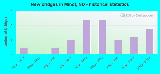
- New bridges - historical statistics
- 21930-1939
- 21950-1959
- 51960-1969
- 121970-1979
- 121980-1989
- 51990-1999
- 62000-2009
- 92010-2019
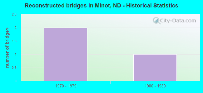
- Reconstructed bridges - Historical Statistics
- 21970-1979
- 11980-1989
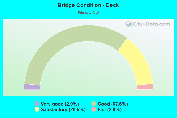
- Bridge Condition - Deck
- 2.9%Very good
- 67.6%Good
- 26.5%Satisfactory
- 2.9%Fair
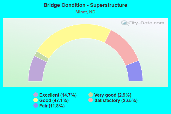
- Bridge Condition - Superstructure
- 14.7%Excellent
- 2.9%Very good
- 47.1%Good
- 23.5%Satisfactory
- 11.8%Fair
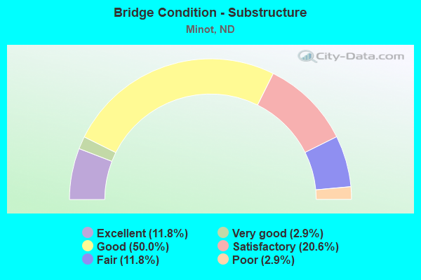
- Bridge Condition - Substructure
- 11.8%Excellent
- 2.9%Very good
- 50.0%Good
- 20.6%Satisfactory
- 11.8%Fair
- 2.9%Poor
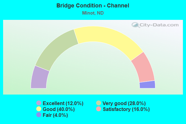
- Bridge Condition - Channel
- 12.0%Excellent
- 28.0%Very good
- 40.0%Good
- 16.0%Satisfactory
- 4.0%Fair
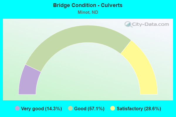
- Bridge Condition - Culverts
- 14.3%Very good
- 57.1%Good
- 28.6%Satisfactory
Find on map >> Show street view
Structure Number: 83921270 L, Location: MINOT WEST BYPASS (Lat: 48.240100, Lng: -101.338100), Route carried "on" structure: Bypass US 83, Year Built: 2019, Status: Open, Structure Length: 4.57m (14.99ft), Average Daily Traffic: 4,665 (year 2019), Truck Traffic: 5%, Average Future Daily Traffic: 7,652 (year 2039), Design Load: HL 93, Features Intersected: COUNTRY CLUB ROAD
Minimum Vertical Clearance: 30+ m (98+ ft), Kilometerpoint: 1482.323, Lanes on structure: 2, Lanes under structure: 2, Base Highway Network: Yes, Owner: State Highway Agency, Approaching Roadway Width: 12.2m (40.0ft), Material/Design: Prestressed concrete, Design/Construction: Box Beam or Girders - Single/Spread, Number Of Spans In Main Unit: 3, Length of Maximum Span: 19.8m (65.0ft), Curb or Sidewalk Widths: Left: 0.4m (1.3ft), Right: 0.4m (1.3ft), Curb-To-Curb Width: 12.2m (40.0ft), Out-to-Out Width: 13.0m (42.7ft)
Condition: Deck: Good, Superstructure: Excellent, Substructure: Excellent, Operating Rating: 45.7 metric tons, Method Used To Determine Operating Rating: Load and Resistance Factor Rating (LRFR) rating reported by rating factor(RF) method using HL-93 loadings, Inventory Rating: 33.7 metric tons, Method Used To Determine Inventory Rating: Load and Resistance Factor Rating (LRFR) rating reported by rating factor(RF) method using HL-93 loadings, Structural Evaluation: Superior to present desirable criteria, Deck Geometry: Equal to present minimum criteria, Underclear: Superior to present desirable criteria, Approach Roadway Alignment: Superior to present desirable criteria, Designated Inspection Frequency: Every 24 months, Inspection Date: November 2021, Deck Structure Type: Concrete Cast-file-Place, Wearing Surface/Protective System: Wearing Surface: Monolithic Concrete, Deck Protection: Epoxy Coated Reinforcing
Find on map >> Show street view
Structure Number: MNOT1, Location: 3RD ST NE-MINOT (Lat: 64.166700, Lng: -21.950000), Route carried "under" structure: City street , Year Built: 1936, Structure Length: 0. m, Average Daily Traffic: 200 (year 2013), Truck Traffic: 4%, Features Intersected: 4TH AVE BNRR SOURIS R., Facility Carried by Structure: 3RD ST. N.E.
Minimum Vertical Clearance: 4.57m (14.99ft), Kilometerpoint: 0.000, Lanes on structure: 2, Lanes under structure: 2, Material/Design: Steel continuous, Design/Construction: Stringer/Multi-beam, Length of Maximum Span: 35.7m (117.1ft)
Find on map >> Show street view
Structure Number: MNOT22 B, Location: 16TH ST SW-MINOT (Lat: 48.227333, Lng: -101.313833), Route carried "under" structure: Business City street 8928, Year Built: 1979, Structure Length: 0. m, Average Daily Traffic: 12,800 (year 2010), Truck Traffic: 1%, Features Intersected: 16 ST. S.W., Facility Carried by Structure: BNSF RAILROAD
Minimum Vertical Clearance: 4.74m (15.55ft), Kilometerpoint: 0.322, Lanes under structure: 5, Material/Design: Steel continuous, Design/Construction: Stringer/Multi-beam, Length of Maximum Span: 20.4m (66.9ft)
Find on map >> Show street view
Structure Number: 2145343, Location: 1 WEST OF U.S. HWY 83 (Lat: 48.210500, Lng: -101.325000), Route carried "under" structure: US 2, Year Built: 1988, Structure Length: 0. m, Average Daily Traffic: 9,600 (year 2011), Truck Traffic: 10%, Features Intersected: U.S. HWY 2 & 52, Facility Carried by Structure: 16TH ST. SW-MINOT
Minimum Vertical Clearance: 5.06m (16.60ft), Kilometerpoint: 233.907, Lanes on structure: 6, Lanes under structure: 2, Material/Design: Steel continuous, Design/Construction: Stringer/Multi-beam, Length of Maximum Span: 36.9m (121.1ft)
Find on map >> Show street view
Structure Number: 2145343, Location: 1 WEST OF U.S. HWY 83 (Lat: 48.210500, Lng: -101.325000), Route carried "under" structure: US 2, Year Built: 1988, Structure Length: 0. m, Average Daily Traffic: 9,600 (year 2011), Truck Traffic: 10%, Features Intersected: U.S. HWY 2 & 52, Facility Carried by Structure: 16TH ST. SW-MINOT
Minimum Vertical Clearance: 4.99m (16.37ft), Kilometerpoint: 233.907, Lanes on structure: 6, Lanes under structure: 2, Material/Design: Steel continuous, Design/Construction: Stringer/Multi-beam, Length of Maximum Span: 36.9m (121.1ft)
Find on map >> Show street view
Structure Number: 2146366, Location: JCT US 83 & US 2-52 (Lat: 48.208333, Lng: -101.295000), Route carried "under" structure: US 2, Year Built: 1977, Structure Length: 0. m, Average Daily Traffic: 11,900 (year 2011), Truck Traffic: 9%, Features Intersected: U.S. HIGHWAY 2 & 52, Facility Carried by Structure: US HIGHWAY 83
Minimum Vertical Clearance: 5.02m (16.47ft), Kilometerpoint: 235.553, Lanes on structure: 6, Lanes under structure: 2, Material/Design: Steel continuous, Design/Construction: Stringer/Multi-beam, Length of Maximum Span: 39.0m (128.0ft)
Find on map >> Show street view
Structure Number: 2146366, Location: JCT US 83 & US 2-52 (Lat: 48.208333, Lng: -101.295000), Route carried "under" structure: US 2, Year Built: 1977, Structure Length: 0. m, Average Daily Traffic: 11,900 (year 2011), Truck Traffic: 9%, Features Intersected: U.S. HIGHWAY 2 & 52, Facility Carried by Structure: US HIGHWAY 83
Minimum Vertical Clearance: 5.92m (19.42ft), Kilometerpoint: 235.553, Lanes on structure: 6, Lanes under structure: 2, Material/Design: Steel continuous, Design/Construction: Stringer/Multi-beam, Length of Maximum Span: 39.0m (128.0ft)
Find on map >> Show street view
Structure Number: 214893, Location: JCT 2 & 52 EAST (Lat: 48.210000, Lng: -101.245000), Route carried "under" structure: US 2, Year Built: 1981, Structure Length: 0. m, Average Daily Traffic: 8,300 (year 2011), Truck Traffic: 8%, Features Intersected: US2/US2 & 52 INT.
Minimum Vertical Clearance: 5.15m (16.90ft), Kilometerpoint: 239.680, Lanes on structure: 2, Lanes under structure: 2, Material/Design: Steel continuous, Design/Construction: Box Beam or Girders - Single/Spread, Length of Maximum Span: 36.3m (119.1ft)
Find on map >> Show street view
Structure Number: 214893, Location: JCT 2 & 52 EAST (Lat: 48.210000, Lng: -101.245000), Route carried "under" structure: US 2, Year Built: 1981, Structure Length: 0. m, Average Daily Traffic: 8,300 (year 2011), Truck Traffic: 8%, Features Intersected: US2/US2 & 52 INT.
Minimum Vertical Clearance: 5.18m (16.99ft), Kilometerpoint: 239.680, Lanes on structure: 2, Lanes under structure: 2, Material/Design: Steel continuous, Design/Construction: Box Beam or Girders - Single/Spread, Length of Maximum Span: 36.3m (119.1ft)
Find on map >> Show street view
Structure Number: 83201739 B, Location: NORTH MINOT (Lat: 48.253197, Lng: -101.295086), Route carried "under" structure: US 83, Year Built: 2007, Structure Length: 0. m, Average Daily Traffic: 25,950 (year 2012), Truck Traffic: 5%, Features Intersected: US HWY 83, Facility Carried by Structure: PED.CROSSOVER
Minimum Vertical Clearance: 5.15m (16.90ft), Kilometerpoint: 324.598, Lanes on structure: 1, Lanes under structure: 2, Material/Design: Prestressed concrete, Design/Construction: Girder and Floorbeam System, Length of Maximum Span: 46.5m (152.6ft)
Find on map >> Show street view
Structure Number: 8392127, Location: MINOT WEST BYPASS (Lat: 48.240100, Lng: -101.337500), Route carried "under" structure: City street , Year Built: 1977, Structure Length: 0. m, Average Daily Traffic: 400 (year 2013), Truck Traffic: 4%, Features Intersected: COUNTRY CLUB ROAD, Facility Carried by Structure: U.S. 83 BYPASS W
Minimum Vertical Clearance: 5.26m (17.26ft), Kilometerpoint: 0.000, Lanes on structure: 2, Lanes under structure: 2, Material/Design: Prestressed concrete continuous, Design/Construction: Box Beam or Girders - Single/Spread, Length of Maximum Span: 19.5m (64.0ft)
Find on map >> Show street view
Structure Number: 83921270 L, Location: MINOT WEST BYPASS (Lat: 48.240100, Lng: -101.338100), Route carried "under" structure: City street , Year Built: 2019, Structure Length: 0. m, Average Daily Traffic: 400 (year 2013), Truck Traffic: 4%, Features Intersected: COUNTRY CLUB ROAD, Facility Carried by Structure: U.S. 83 BYPASS W
Minimum Vertical Clearance: 5.26m (17.26ft), Kilometerpoint: 0.000, Lanes on structure: 2, Lanes under structure: 2, Material/Design: Prestressed concrete, Design/Construction: Box Beam or Girders - Single/Spread, Length of Maximum Span: 19.8m (65.0ft)