Bridge Statistics for Mobile, Alabama (AL)
Condition, Traffic, Stress, Structural Evaluation, Project Costs
- National Bridge Inventory (NBI) Statistics
- 342Number of bridges
- 17,884ft / 5,451mTotal length
- $2,276,753,000Total costs
- 5,331,403Total average daily traffic
- 449,063Total average daily truck traffic
- National Bridge Inventory (NBI) Registered Bridges for Mobile
- No street view available for this location
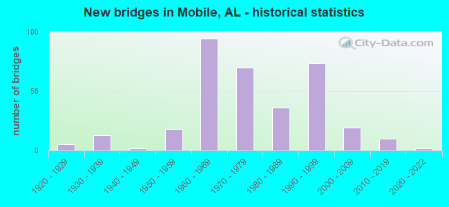
- New bridges - historical statistics
- 51920-1929
- 131930-1939
- 21940-1949
- 181950-1959
- 941960-1969
- 701970-1979
- 361980-1989
- 731990-1999
- 192000-2009
- 102010-2019
- 22020-2022
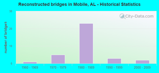
- Reconstructed bridges - Historical Statistics
- 11960-1969
- 51970-1979
- 231980-1989
- 31990-1999
- 22000-2009
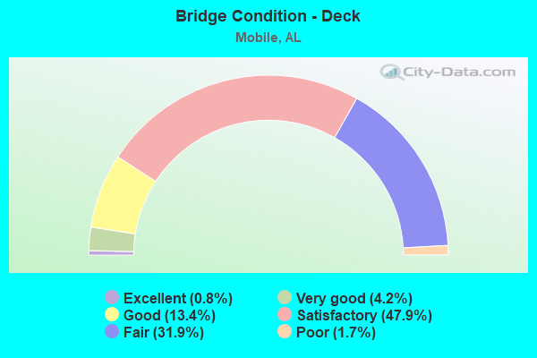
- Bridge Condition - Deck
- 0.8%Excellent
- 4.2%Very good
- 13.4%Good
- 47.9%Satisfactory
- 31.9%Fair
- 1.7%Poor
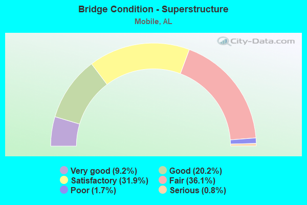
- Bridge Condition - Superstructure
- 9.2%Very good
- 20.2%Good
- 31.9%Satisfactory
- 36.1%Fair
- 1.7%Poor
- 0.8%Serious

- Bridge Condition - Substructure
- 5.0%Very good
- 23.5%Good
- 34.5%Satisfactory
- 32.8%Fair
- 2.5%Poor
- 1.7%Serious
- 0.8%Critical
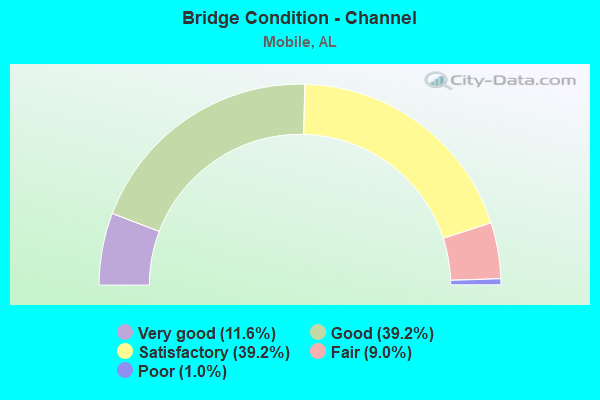
- Bridge Condition - Channel
- 11.6%Very good
- 39.2%Good
- 39.2%Satisfactory
- 9.0%Fair
- 1.0%Poor
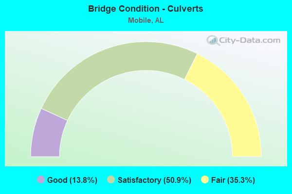
- Bridge Condition - Culverts
- 13.8%Good
- 50.9%Satisfactory
- 35.3%Fair
Find on map >> Show street view
Structure Number: 8959, Location: I-10 @ SR 163 INTERCHANGE (Lat: 30.640767, Lng: -88.089372), Route carried "under" structure: Ramp Interstate 10, Year Built: 1966, Structure Length: 0. m, Average Daily Traffic: 3,213 (year 2018), Truck Traffic: 3%, Features Intersected: I-10 * SR 163
Minimum Vertical Clearance: 5.19m (17.03ft), Kilometerpoint: 35.904, Lanes on structure: 1, Lanes under structure: 1, Material/Design: Prestressed concrete continuous, Design/Construction: Box Beam or Girders - Single/Spread, Length of Maximum Span: 30.5m (100.1ft)
Find on map >> Show street view
Structure Number: 8959, Location: I-10 @ SR 163 INTERCHANGE (Lat: 30.640767, Lng: -88.089372), Route carried "under" structure: Interstate 10, Year Built: 1966, Structure Length: 0. m, Average Daily Traffic: 43,524 (year 2018), Truck Traffic: 13%, Features Intersected: I-10 * SR 163
Minimum Vertical Clearance: 4.93m (16.17ft), Kilometerpoint: 35.909, Lanes on structure: 1, Lanes under structure: 7, Material/Design: Prestressed concrete continuous, Design/Construction: Box Beam or Girders - Single/Spread, Length of Maximum Span: 30.5m (100.1ft)
Find on map >> Show street view
Structure Number: 8997, Location: I-10 @ I-65 INTERCHANGE (Lat: 30.627972, Lng: -88.118000), Route carried "under" structure: Ramp Interstate 10, Year Built: 1966, Structure Length: 0. m, Average Daily Traffic: 44,098 (year 2018), Truck Traffic: 12%, Features Intersected: I-10 WB
Minimum Vertical Clearance: 5.24m (17.19ft), Kilometerpoint: 33.088, Lanes on structure: 2, Lanes under structure: 3, Material/Design: Concrete continuous, Design/Construction: Box Beam or Girders - Single/Spread, Length of Maximum Span: 26.2m (86.0ft)
Find on map >> Show street view
Structure Number: 8998, Location: I-10 @ I-65 INTERCHANGE (Lat: 30.628556, Lng: -88.114972), Route carried "under" structure: Ramp Interstate 10, Year Built: 1966, Structure Length: 0. m, Average Daily Traffic: 44,098 (year 2018), Truck Traffic: 12%, Features Intersected: I-10 WB
Minimum Vertical Clearance: 5.36m (17.59ft), Kilometerpoint: 32.847, Lanes on structure: 2, Lanes under structure: 3, Material/Design: Concrete continuous, Design/Construction: Box Beam or Girders - Single/Spread, Length of Maximum Span: 38.1m (125.0ft)
Find on map >> Show street view
Structure Number: 8999, Location: I-10 @ I-65 (Lat: 30.629850, Lng: -88.117519), Route carried "under" structure: Ramp Interstate 65, Year Built: 1966, Structure Length: 0. m, Average Daily Traffic: 27,386 (year 2018), Truck Traffic: 13%, Features Intersected: I-65 NB
Minimum Vertical Clearance: 4.93m (16.17ft), Kilometerpoint: 0.534, Lanes on structure: 2, Lanes under structure: 2, Material/Design: Concrete continuous, Design/Construction: Box Beam or Girders - Single/Spread, Length of Maximum Span: 32.6m (107.0ft)
Find on map >> Show street view
Structure Number: 9177, Location: SR 163 @ I-10 INTERCHANGE (Lat: 30.639158, Lng: -88.089000), Route carried "under" structure: Interstate 10, Year Built: 1966, Structure Length: 0. m, Features Intersected: I-10/CSX RR, Facility Carried by Structure: SR 163
Minimum Vertical Clearance: 6.90m (22.64ft), Kilometerpoint: 35.755, Lanes on structure: 4, Lanes under structure: 8, Material/Design: Concrete continuous, Design/Construction: Box Beam or Girders - Multiple, Length of Maximum Span: 35.7m (117.1ft)
Find on map >> Show street view
Structure Number: 9177, Location: SR 163 @ I-10 INTERCHANGE (Lat: 30.639158, Lng: -88.089000), Route carried "under" structure: Interstate 10, Year Built: 1966, Structure Length: 0. m, Average Daily Traffic: 44,456 (year 2019), Truck Traffic: 13%, Features Intersected: I-10/CSX RR, Facility Carried by Structure: SR 163
Minimum Vertical Clearance: 4.90m (16.08ft), Kilometerpoint: 35.760, Lanes on structure: 4, Lanes under structure: 1, Material/Design: Concrete continuous, Design/Construction: Box Beam or Girders - Multiple, Length of Maximum Span: 35.7m (117.1ft)
Find on map >> Show street view
Structure Number: 9177, Location: SR 163 @ I-10 INTERCHANGE (Lat: 30.639158, Lng: -88.089000), Route carried "under" structure: Ramp Interstate 10, Year Built: 1966, Structure Length: 0. m, Average Daily Traffic: 3,245 (year 2019), Truck Traffic: 3%, Features Intersected: I-10/CSX RR, Facility Carried by Structure: SR 163
Minimum Vertical Clearance: 11.87m (38.94ft), Kilometerpoint: 35.758, Lanes on structure: 4, Lanes under structure: 1, Material/Design: Concrete continuous, Design/Construction: Box Beam or Girders - Multiple, Length of Maximum Span: 35.7m (117.1ft)
Find on map >> Show street view
Structure Number: 9177, Location: SR 163 @ I-10 INTERCHANGE (Lat: 30.639158, Lng: -88.089000), Route carried "under" structure: State highway 163, Year Built: 1966, Structure Length: 0. m, Average Daily Traffic: 44,456 (year 2019), Truck Traffic: 13%, Features Intersected: I-10/CSX RR
Minimum Vertical Clearance: 11.90m (39.04ft), Kilometerpoint: 35.755, Lanes on structure: 4, Lanes under structure: 1, Material/Design: Concrete continuous, Design/Construction: Box Beam or Girders - Multiple, Length of Maximum Span: 35.7m (117.1ft)
Find on map >> Show street view
Structure Number: 9177, Location: SR 163 @ I-10 INTERCHANGE (Lat: 30.639158, Lng: -88.089000), Route carried "under" structure: Ramp Interstate 10, Year Built: 1966, Structure Length: 0. m, Average Daily Traffic: 2,731 (year 2019), Truck Traffic: 4%, Features Intersected: I-10/CSX RR, Facility Carried by Structure: SR 163
Minimum Vertical Clearance: 5.07m (16.63ft), Kilometerpoint: 35.761, Lanes on structure: 4, Lanes under structure: 3, Material/Design: Concrete continuous, Design/Construction: Box Beam or Girders - Multiple, Length of Maximum Span: 35.7m (117.1ft)
Find on map >> Show street view
Structure Number: 9177, Location: SR 163 @ I-10 INTERCHANGE (Lat: 30.639158, Lng: -88.089000), Route carried "under" structure: Interstate 10, Year Built: 1966, Structure Length: 0. m, Average Daily Traffic: 5,281 (year 2019), Truck Traffic: 3%, Features Intersected: I-10/CSX RR, Facility Carried by Structure: SR 163
Minimum Vertical Clearance: 4.99m (16.37ft), Kilometerpoint: 35.763, Lanes on structure: 4, Lanes under structure: 7, Material/Design: Concrete continuous, Design/Construction: Box Beam or Girders - Multiple, Length of Maximum Span: 35.7m (117.1ft)
Find on map >> Show street view
Structure Number: 10663, Location: WEST TUNNEL INTERCHANGE (Lat: 30.683011, Lng: -88.042764), Route carried "under" structure: City street , Year Built: 1972, Structure Length: 0. m, Average Daily Traffic: 547 (year 2018), Truck Traffic: 3%, Features Intersected: CANAL ST * JACKSON ST, Facility Carried by Structure: I-10 WB
Minimum Vertical Clearance: 5.66m (18.57ft), Kilometerpoint: 0.000, Lanes on structure: 4, Lanes under structure: 2, Material/Design: Steel, Design/Construction: Stringer/Multi-beam, Length of Maximum Span: 37.8m (124.0ft)
Find on map >> Show street view
Structure Number: 10663, Location: WEST TUNNEL INTERCHANGE (Lat: 30.683011, Lng: -88.042764), Route carried "under" structure: City street , Year Built: 1972, Structure Length: 0. m, Average Daily Traffic: 4,892 (year 2018), Truck Traffic: 5%, Features Intersected: CANAL ST * JACKSON ST, Facility Carried by Structure: I-10 WB
Minimum Vertical Clearance: 4.86m (15.94ft), Kilometerpoint: 0.000, Lanes on structure: 4, Lanes under structure: 7, Material/Design: Steel, Design/Construction: Stringer/Multi-beam, Length of Maximum Span: 37.8m (124.0ft)
Find on map >> Show street view
Structure Number: 10664, Location: WEST TUNNEL INTERCHANGE (Lat: 30.682972, Lng: -88.042461), Route carried "under" structure: City street , Year Built: 1972, Structure Length: 0. m, Average Daily Traffic: 8,174 (year 2018), Truck Traffic: 1%, Features Intersected: CANAL; JACKSON; RAMP 6, Facility Carried by Structure: I-10 EB
Minimum Vertical Clearance: 5.03m (16.50ft), Kilometerpoint: 0.000, Lanes on structure: 2, Lanes under structure: 2, Material/Design: Steel, Design/Construction: Stringer/Multi-beam, Length of Maximum Span: 40.8m (133.9ft)
Find on map >> Show street view
Structure Number: 10664, Location: WEST TUNNEL INTERCHANGE (Lat: 30.682972, Lng: -88.042461), Route carried "under" structure: City street , Year Built: 1972, Structure Length: 0. m, Average Daily Traffic: 4,892 (year 2018), Truck Traffic: 10%, Features Intersected: CANAL; JACKSON; RAMP 6, Facility Carried by Structure: I-10 EB
Minimum Vertical Clearance: 5.97m (19.59ft), Kilometerpoint: 26.532, Lanes on structure: 2, Lanes under structure: 7, Material/Design: Steel, Design/Construction: Stringer/Multi-beam, Length of Maximum Span: 40.8m (133.9ft)
Find on map >> Show street view
Structure Number: 10664, Location: WEST TUNNEL INTERCHANGE (Lat: 30.682972, Lng: -88.042461), Route carried "under" structure: Ramp City street 10, Year Built: 1972, Structure Length: 0. m, Average Daily Traffic: 547 (year 2018), Truck Traffic: 13%, Features Intersected: CANAL; JACKSON; RAMP 6
Minimum Vertical Clearance: 5.03m (16.50ft), Kilometerpoint: 42.532, Lanes on structure: 2, Lanes under structure: 2, Material/Design: Steel, Design/Construction: Stringer/Multi-beam, Length of Maximum Span: 40.8m (133.9ft)
Find on map >> Show street view
Structure Number: 10665, Location: WEST TUNNEL INTERCHANGE (Lat: 30.685589, Lng: -88.040456), Route carried "under" structure: Interstate 10, Year Built: 1972, Structure Length: 0. m, Average Daily Traffic: 41,630 (year 2018), Truck Traffic: 13%, Features Intersected: I10-EB/WB/RAMP TO WB I10
Minimum Vertical Clearance: 5.11m (16.77ft), Kilometerpoint: 42.825, Lanes on structure: 1, Lanes under structure: 2, Material/Design: Prestressed concrete, Design/Construction: Stringer/Multi-beam, Length of Maximum Span: 24.4m (80.1ft)
Find on map >> Show street view
Structure Number: 10665, Location: WEST TUNNEL INTERCHANGE (Lat: 30.685589, Lng: -88.040456), Route carried "under" structure: Ramp Interstate 10, Year Built: 1972, Structure Length: 0. m, Average Daily Traffic: 4,881 (year 2018), Truck Traffic: 15%, Features Intersected: I10-EB/WB/RAMP TO WB I10
Minimum Vertical Clearance: 12.55m (41.17ft), Kilometerpoint: 42.825, Lanes on structure: 1, Lanes under structure: 2, Material/Design: Prestressed concrete, Design/Construction: Stringer/Multi-beam, Length of Maximum Span: 24.4m (80.1ft)
Find on map >> Show street view
Structure Number: 10665, Location: WEST TUNNEL INTERCHANGE (Lat: 30.685589, Lng: -88.040456), Route carried "under" structure: Interstate 10, Year Built: 1972, Structure Length: 0. m, Average Daily Traffic: 41,630 (year 2018), Truck Traffic: 13%, Features Intersected: I10-EB/WB/RAMP TO WB I10
Minimum Vertical Clearance: 6.06m (19.88ft), Kilometerpoint: 42.825, Lanes on structure: 1, Lanes under structure: 2, Material/Design: Prestressed concrete, Design/Construction: Stringer/Multi-beam, Length of Maximum Span: 24.4m (80.1ft)
Find on map >> Show street view
Structure Number: 10666, Location: WEST TUNNEL INTERCHANGE (Lat: 30.683897, Lng: -88.041892), Route carried "under" structure: City street , Year Built: 1972, Structure Length: 0. m, Average Daily Traffic: 221 (year 2018), Truck Traffic: 1%, Features Intersected: ROYAL/MONROE ST'S, Facility Carried by Structure: I-10EB TO WATER ST
Minimum Vertical Clearance: 5.74m (18.83ft), Kilometerpoint: 0.000, Lanes on structure: 2, Lanes under structure: 2, Material/Design: Prestressed concrete, Design/Construction: Stringer/Multi-beam, Length of Maximum Span: 26.8m (87.9ft)
Find on map >> Show street view
Structure Number: 10667, Location: WEST TUNNEL INTERCHANGE (Lat: 30.686450, Lng: -88.039881), Route carried "under" structure: City street , Year Built: 1972, Structure Length: 0. m, Average Daily Traffic: 221 (year 2018), Truck Traffic: 5%, Features Intersected: ROYAL ST, Facility Carried by Structure: WATER ST TO I10E/W
Minimum Vertical Clearance: 5.57m (18.27ft), Kilometerpoint: 0.000, Lanes on structure: 2, Lanes under structure: 2, Material/Design: Prestressed concrete, Design/Construction: Stringer/Multi-beam, Length of Maximum Span: 26.2m (86.0ft)
Find on map >> Show street view
Structure Number: 10853, Location: EAST TUNNEL INTERCHANGE (Lat: 30.691533, Lng: -88.027283), Route carried "under" structure: US 90, Year Built: 1973, Structure Length: 0. m, Average Daily Traffic: 16,609 (year 2019), Truck Traffic: 4%, Features Intersected: US 90 EB * WB
Minimum Vertical Clearance: 4.94m (16.21ft), Kilometerpoint: 58.585, Lanes on structure: 1, Lanes under structure: 4, Material/Design: Prestressed concrete, Design/Construction: Stringer/Multi-beam, Length of Maximum Span: 21.3m (69.9ft)
Find on map >> Show street view
Structure Number: 10853, Location: EAST TUNNEL INTERCHANGE (Lat: 30.691533, Lng: -88.027283), Route carried "under" structure: US 98, Year Built: 1973, Structure Length: 0. m, Average Daily Traffic: 16,609 (year 2019), Truck Traffic: 4%, Features Intersected: US 90 EB * WB, Facility Carried by Structure: US 90 EB TO I10 EB
Minimum Vertical Clearance: 5.28m (17.32ft), Kilometerpoint: 44.468, Lanes on structure: 1, Lanes under structure: 4, Material/Design: Prestressed concrete, Design/Construction: Stringer/Multi-beam, Length of Maximum Span: 21.3m (69.9ft)
Find on map >> Show street view
Structure Number: 10853, Location: EAST TUNNEL INTERCHANGE (Lat: 30.691533, Lng: -88.027283), Route carried "under" structure: Ramp Interstate 10, Year Built: 1973, Structure Length: 0. m, Average Daily Traffic: 8,250 (year 2019), Truck Traffic: 11%, Features Intersected: US 90 EB * WB
Minimum Vertical Clearance: 4.94m (16.21ft), Kilometerpoint: 44.465, Lanes on structure: 1, Lanes under structure: 6, Material/Design: Prestressed concrete, Design/Construction: Stringer/Multi-beam, Length of Maximum Span: 21.3m (69.9ft)
Find on map >> Show street view
Structure Number: 11702, Location: 1.3 MI S HAMILTON BLVD (Lat: 30.531428, Lng: -88.123478), Route carried "under" structure: ServiceCounty highway , Year Built: 1976, Structure Length: 0. m, Average Daily Traffic: 68 (year 2018), Features Intersected: THEODORE INDS CANAL, Facility Carried by Structure: SR 193
Minimum Vertical Clearance: 5.38m (17.65ft), Kilometerpoint: 0.000, Lanes on structure: 2, Lanes under structure: 2, Material/Design: Steel continuous, Design/Construction: Stringer/Multi-beam, Length of Maximum Span: 45.7m (149.9ft)
Find on map >> Show street view
Structure Number: 11702, Location: 1.3 MI S HAMILTON BLVD (Lat: 30.531428, Lng: -88.123478), Route carried "under" structure: ServiceCounty highway , Year Built: 1976, Structure Length: 0. m, Average Daily Traffic: 383 (year 2018), Truck Traffic: 5%, Features Intersected: THEODORE INDS CANAL, Facility Carried by Structure: SR 193
Minimum Vertical Clearance: 9.75m (31.99ft), Kilometerpoint: 0.000, Lanes on structure: 2, Lanes under structure: 2, Material/Design: Steel continuous, Design/Construction: Stringer/Multi-beam, Length of Maximum Span: 45.7m (149.9ft)
Find on map >> Show street view
Structure Number: 1193, Location: EAST TUNNEL INTERCHANGE (Lat: 30.692000, Lng: -88.028917), Route carried "under" structure: US 98, Year Built: 1978, Structure Length: 0. m, Average Daily Traffic: 7,521 (year 2020), Truck Traffic: 11%, Features Intersected: M. BAY,90,98,I10WB RAMP, Facility Carried by Structure: I-10 WB
Minimum Vertical Clearance: 4.95m (16.24ft), Kilometerpoint: 44.370, Lanes on structure: 2, Lanes under structure: 4, Material/Design: Steel continuous, Design/Construction: Stringer/Multi-beam, Length of Maximum Span: 46.9m (153.9ft)
Find on map >> Show street view
Structure Number: 1193, Location: EAST TUNNEL INTERCHANGE (Lat: 30.692000, Lng: -88.028917), Route carried "under" structure: US 90, Year Built: 1978, Structure Length: 0. m, Average Daily Traffic: 9,979 (year 2020), Truck Traffic: 8%, Features Intersected: M. BAY,90,98,I10WB RAMP, Facility Carried by Structure: I-10 WB
Minimum Vertical Clearance: 6.32m (20.73ft), Kilometerpoint: 58.344, Lanes on structure: 2, Lanes under structure: 4, Material/Design: Steel continuous, Design/Construction: Stringer/Multi-beam, Length of Maximum Span: 46.9m (153.9ft)
Find on map >> Show street view
Structure Number: 1193, Location: EAST TUNNEL INTERCHANGE (Lat: 30.692000, Lng: -88.028917), Route carried "under" structure: US 98, Year Built: 1978, Structure Length: 0. m, Average Daily Traffic: 12,696 (year 2020), Truck Traffic: 5%, Features Intersected: M. BAY,90,98,I10WB RAMP, Facility Carried by Structure: I-10 WB
Minimum Vertical Clearance: 5.23m (17.16ft), Kilometerpoint: 66.244, Lanes on structure: 2, Lanes under structure: 4, Material/Design: Steel continuous, Design/Construction: Stringer/Multi-beam, Length of Maximum Span: 46.9m (153.9ft)
Find on map >> Show street view
Structure Number: 1193, Location: EAST TUNNEL INTERCHANGE (Lat: 30.692000, Lng: -88.028917), Route carried "under" structure: US 90, Year Built: 1978, Structure Length: 0. m, Average Daily Traffic: 12,696 (year 2020), Truck Traffic: 5%, Features Intersected: M. BAY,90,98,I10WB RAMP, Facility Carried by Structure: I-10 WB
Minimum Vertical Clearance: 5.03m (16.50ft), Kilometerpoint: 62.608, Lanes on structure: 2, Lanes under structure: 4, Material/Design: Steel continuous, Design/Construction: Stringer/Multi-beam, Length of Maximum Span: 46.9m (153.9ft)
Find on map >> Show street view
Structure Number: 1193, Location: EAST TUNNEL INTERCHANGE (Lat: 30.692000, Lng: -88.028917), Route carried "under" structure: Ramp Interstate 10, Year Built: 1978, Structure Length: 0. m, Average Daily Traffic: 9,979 (year 2020), Truck Traffic: 8%, Features Intersected: M. BAY,90,98,I10WB RAMP
Minimum Vertical Clearance: 5.60m (18.37ft), Kilometerpoint: 44.366, Lanes on structure: 2, Lanes under structure: 4, Material/Design: Steel continuous, Design/Construction: Stringer/Multi-beam, Length of Maximum Span: 46.9m (153.9ft)
Find on map >> Show street view
Structure Number: 1193, Location: EAST TUNNEL INTERCHANGE (Lat: 30.692000, Lng: -88.028917), Route carried "under" structure: Ramp US 10, Year Built: 1978, Structure Length: 0. m, Average Daily Traffic: 4,598 (year 2020), Truck Traffic: 1%, Features Intersected: M. BAY,90,98,I10WB RAMP
Minimum Vertical Clearance: 4.91m (16.11ft), Kilometerpoint: 44.366, Lanes on structure: 2, Lanes under structure: 4, Material/Design: Steel continuous, Design/Construction: Stringer/Multi-beam, Length of Maximum Span: 46.9m (153.9ft)
Find on map >> Show street view
Structure Number: 11931, Location: EAST TUNNEL INTERCHANGE (Lat: 30.691853, Lng: -88.028883), Route carried "under" structure: Ramp Interstate 10, Year Built: 1978, Structure Length: 0. m, Average Daily Traffic: 7,521 (year 2020), Truck Traffic: 11%, Features Intersected: MOBILE BAY * US 90
Minimum Vertical Clearance: 6.14m (20.14ft), Kilometerpoint: 44.370, Lanes on structure: 2, Lanes under structure: 5, Material/Design: Steel continuous, Design/Construction: Stringer/Multi-beam, Length of Maximum Span: 46.9m (153.9ft)
Find on map >> Show street view
Structure Number: 11931, Location: EAST TUNNEL INTERCHANGE (Lat: 30.691853, Lng: -88.028883), Route carried "under" structure: US 90, Year Built: 1978, Structure Length: 0. m, Average Daily Traffic: 12,696 (year 2020), Truck Traffic: 4%, Features Intersected: MOBILE BAY * US 90, Facility Carried by Structure: I-10 EB
Minimum Vertical Clearance: 5.26m (17.26ft), Kilometerpoint: 62.528, Lanes on structure: 2, Lanes under structure: 5, Material/Design: Steel continuous, Design/Construction: Stringer/Multi-beam, Length of Maximum Span: 46.9m (153.9ft)
Find on map >> Show street view
Structure Number: 11931, Location: EAST TUNNEL INTERCHANGE (Lat: 30.691853, Lng: -88.028883), Route carried "under" structure: US 98, Year Built: 1978, Structure Length: 0. m, Average Daily Traffic: 12,696 (year 2020), Truck Traffic: 4%, Features Intersected: MOBILE BAY * US 90, Facility Carried by Structure: I-10 EB
Minimum Vertical Clearance: 5.12m (16.80ft), Kilometerpoint: 66.083, Lanes on structure: 2, Lanes under structure: 5, Material/Design: Steel continuous, Design/Construction: Stringer/Multi-beam, Length of Maximum Span: 46.9m (153.9ft)
Find on map >> Show street view
Structure Number: 11931, Location: EAST TUNNEL INTERCHANGE (Lat: 30.691853, Lng: -88.028883), Route carried "under" structure: Ramp Interstate 10, Year Built: 1978, Structure Length: 0. m, Average Daily Traffic: 4,598 (year 2020), Truck Traffic: 1%, Features Intersected: MOBILE BAY * US 90
Minimum Vertical Clearance: 6.06m (19.88ft), Kilometerpoint: 44.366, Lanes on structure: 2, Lanes under structure: 5, Material/Design: Steel continuous, Design/Construction: Stringer/Multi-beam, Length of Maximum Span: 46.9m (153.9ft)
Find on map >> Show street view
Structure Number: 11931, Location: EAST TUNNEL INTERCHANGE (Lat: 30.691853, Lng: -88.028883), Route carried "under" structure: US 9, Year Built: 1978, Structure Length: 0. m, Average Daily Traffic: 9,979 (year 2020), Truck Traffic: 8%, Features Intersected: MOBILE BAY * US 90, Facility Carried by Structure: I-10 EB
Minimum Vertical Clearance: 6.06m (19.88ft), Kilometerpoint: 44.366, Lanes on structure: 2, Lanes under structure: 5, Material/Design: Steel continuous, Design/Construction: Stringer/Multi-beam, Length of Maximum Span: 46.9m (153.9ft)
Find on map >> Show street view
Structure Number: 11931, Location: EAST TUNNEL INTERCHANGE (Lat: 30.691853, Lng: -88.028883), Route carried "under" structure: US 90, Year Built: 1978, Structure Length: 0. m, Average Daily Traffic: 9,979 (year 2020), Truck Traffic: 8%, Features Intersected: MOBILE BAY * US 90, Facility Carried by Structure: I-10 EB
Minimum Vertical Clearance: 6.65m (21.82ft), Kilometerpoint: 58.263, Lanes on structure: 2, Lanes under structure: 5, Material/Design: Steel continuous, Design/Construction: Stringer/Multi-beam, Length of Maximum Span: 46.9m (153.9ft)
Find on map >> Show street view
Structure Number: 13063, Location: 0.7 MI S I-10 (Lat: 30.588919, Lng: -88.145092), Route carried "under" structure: ServiceCounty highway , Year Built: 1983, Structure Length: 0. m, Average Daily Traffic: 1,011 (year 2019), Truck Traffic: 25%, Features Intersected: CSX RR / TILLMANS CRN, Facility Carried by Structure: SR 193 NB
Minimum Vertical Clearance: 8.28m (27.17ft), Kilometerpoint: 0.000, Lanes on structure: 2, Lanes under structure: 2, Material/Design: Steel continuous, Design/Construction: Stringer/Multi-beam, Length of Maximum Span: 30.5m (100.1ft)
Find on map >> Show street view
Structure Number: 13063, Location: 0.7 MI S I-10 (Lat: 30.588919, Lng: -88.145092), Route carried "under" structure: ServiceCounty highway , Year Built: 1983, Structure Length: 0. m, Average Daily Traffic: 1,163 (year 2019), Truck Traffic: 8%, Features Intersected: CSX RR / TILLMANS CRN, Facility Carried by Structure: SR 193 NB
Minimum Vertical Clearance: 8.49m (27.85ft), Kilometerpoint: 0.000, Lanes on structure: 2, Lanes under structure: 2, Material/Design: Steel continuous, Design/Construction: Stringer/Multi-beam, Length of Maximum Span: 30.5m (100.1ft)
Find on map >> Show street view
Structure Number: 13798, Location: I65 @ US 98 (Lat: 30.706203, Lng: -88.122500), Route carried "under" structure: US 98, Year Built: 1960, Structure Length: 0. m, Average Daily Traffic: 38,241 (year 2018), Truck Traffic: 5%, Features Intersected: ICG RR * US 98, Facility Carried by Structure: I-65
Minimum Vertical Clearance: 5.75m (18.86ft), Kilometerpoint: 34.998, Lanes on structure: 8, Lanes under structure: 4, Material/Design: Concrete continuous, Design/Construction: Tee Beam, Length of Maximum Span: 27.4m (89.9ft)
Find on map >> Show street view
Structure Number: 13806, Location: I-65 @ US 90 (Lat: 30.651764, Lng: -88.122303), Route carried "under" structure: US 90, Year Built: 1961, Structure Length: 0. m, Average Daily Traffic: 40,205 (year 2018), Truck Traffic: 5%, Features Intersected: US 90, Facility Carried by Structure: I-65
Minimum Vertical Clearance: 4.93m (16.17ft), Kilometerpoint: 37.684, Lanes on structure: 8, Lanes under structure: 6, Material/Design: Concrete continuous, Design/Construction: Tee Beam, Length of Maximum Span: 22.9m (75.1ft)
Find on map >> Show street view
Structure Number: 13807, Location: 0.6 MI N US 90 (Lat: 30.661183, Lng: -88.126214), Route carried "under" structure: County highway 40, Year Built: 1961, Structure Length: 0. m, Average Daily Traffic: 31,486 (year 2018), Truck Traffic: 5%, Features Intersected: COTTAGE HILL RD, Facility Carried by Structure: I-65
Minimum Vertical Clearance: 4.78m (15.68ft), Kilometerpoint: 0.000, Lanes on structure: 6, Lanes under structure: 8, Material/Design: Concrete continuous, Design/Construction: Tee Beam, Length of Maximum Span: 19.2m (63.0ft)
Find on map >> Show street view
Structure Number: 13809, Location: I-65 @ DAUPHIN ST (Lat: 30.688183, Lng: -88.126803), Route carried "under" structure: Interstate 65, Year Built: 1962, Structure Length: 0. m, Average Daily Traffic: 100,554 (year 2018), Truck Traffic: 6%, Features Intersected: I-65, Facility Carried by Structure: DAUPHIN ST
Minimum Vertical Clearance: 5.07m (16.63ft), Kilometerpoint: 7.182, Lanes on structure: 6, Lanes under structure: 6, Material/Design: Concrete continuous, Design/Construction: Tee Beam, Length of Maximum Span: 23.8m (78.1ft)
Find on map >> Show street view
Structure Number: 1381, Location: 0.5 MI S US 98 (Lat: 30.698414, Lng: -88.124233), Route carried "under" structure: City street , Year Built: 1962, Structure Length: 0. m, Average Daily Traffic: 16,885 (year 2018), Truck Traffic: 5%, Features Intersected: OLD SHELL RD, Facility Carried by Structure: I-65
Minimum Vertical Clearance: 4.77m (15.65ft), Kilometerpoint: 0.000, Lanes on structure: 7, Lanes under structure: 2, Material/Design: Concrete continuous, Design/Construction: Tee Beam, Length of Maximum Span: 20.7m (67.9ft)
Find on map >> Show street view
Structure Number: 13811, Location: 0.2 MI S US 98 (Lat: 30.703442, Lng: -88.123167), Route carried "under" structure: City street , Year Built: 1962, Structure Length: 0. m, Average Daily Traffic: 33,748 (year 2018), Truck Traffic: 3%, Features Intersected: SPRING HILL AVE, Facility Carried by Structure: I-65
Minimum Vertical Clearance: 4.82m (15.81ft), Kilometerpoint: 0.000, Lanes on structure: 7, Lanes under structure: 5, Material/Design: Concrete continuous, Design/Construction: Tee Beam, Length of Maximum Span: 24.4m (80.1ft)
Find on map >> Show street view
Structure Number: 14005, Location: 781 N. E. WATER STREET (Lat: 30.701344, Lng: -88.041892), Route carried "under" structure: City street , Year Built: 1986, Structure Length: 0. m, Average Daily Traffic: 250 (year 1990), Truck Traffic: 30%, Features Intersected: CSX R.R., Facility Carried by Structure: ACCESS AL ST DOCK
Minimum Vertical Clearance: 5.23m (17.16ft), Kilometerpoint: 0.150, Lanes on structure: 2, Lanes under structure: 2, Material/Design: Steel, Design/Construction: Stringer/Multi-beam, Length of Maximum Span: 36.9m (121.1ft)
Find on map >> Show street view
Structure Number: 14741, Location: 1 MI W SR 163 (Lat: 30.632067, Lng: -88.105383), Route carried "under" structure: City street , Year Built: 1964, Structure Length: 0. m, Average Daily Traffic: 7,451 (year 2020), Truck Traffic: 4%, Features Intersected: NAVCO RD, Facility Carried by Structure: I-10 WB * EB
Minimum Vertical Clearance: 4.44m (14.57ft), Kilometerpoint: 0.000, Lanes on structure: 8, Lanes under structure: 2, Material/Design: Concrete, Design/Construction: Tee Beam, Length of Maximum Span: 17.1m (56.1ft)
Find on map >> Show street view
Structure Number: 14743, Location: 3 MI E SR 163 (Lat: 30.667322, Lng: -88.049897), Route carried "under" structure: City street , Year Built: 1964, Structure Length: 0. m, Average Daily Traffic: 79 (year 2018), Truck Traffic: 1%, Features Intersected: ICG RR * TENN ST, Facility Carried by Structure: I-10 WB * EB
Minimum Vertical Clearance: 7.89m (25.89ft), Kilometerpoint: 0.000, Lanes on structure: 10, Lanes under structure: 2, Material/Design: Concrete, Design/Construction: Tee Beam, Length of Maximum Span: 17.7m (58.1ft)
Find on map >> Show street view
Structure Number: 14753, Location: 1.8 MI E SR 163 (Lat: 30.655200, Lng: -88.066583), Route carried "under" structure: City street , Year Built: 1966, Structure Length: 0. m, Average Daily Traffic: 1,176 (year 2018), Truck Traffic: 5%, Features Intersected: DUVAL STREET, Facility Carried by Structure: I-10 WB * EB
Minimum Vertical Clearance: 4.32m (14.17ft), Kilometerpoint: 0.000, Lanes on structure: 8, Lanes under structure: 4, Material/Design: Concrete continuous, Design/Construction: Tee Beam, Length of Maximum Span: 22.3m (73.2ft)
Find on map >> Show street view
Structure Number: 14754, Location: 2.4 MI E SR 163 (Lat: 30.660850, Lng: -88.058400), Route carried "under" structure: City street , Year Built: 1966, Structure Length: 0. m, Average Daily Traffic: 5,709 (year 2018), Truck Traffic: 2%, Features Intersected: BROAD STREET, Facility Carried by Structure: I-10 WB * EB
Minimum Vertical Clearance: 4.66m (15.29ft), Kilometerpoint: 0.000, Lanes on structure: 8, Lanes under structure: 4, Material/Design: Concrete continuous, Design/Construction: Tee Beam, Length of Maximum Span: 26.5m (86.9ft)
Find on map >> Show street view
Structure Number: 14755, Location: 3.1 MI E SR 163 (Lat: 30.668686, Lng: -88.048811), Route carried "under" structure: City street , Year Built: 1966, Structure Length: 0. m, Average Daily Traffic: 187 (year 2018), Truck Traffic: 1%, Features Intersected: SOUTH CAROLINA ST, Facility Carried by Structure: I-10 WB * EB
Minimum Vertical Clearance: 4.51m (14.80ft), Kilometerpoint: 0.000, Lanes on structure: 10, Lanes under structure: 4, Material/Design: Concrete, Design/Construction: Tee Beam, Length of Maximum Span: 16.8m (55.1ft)
Find on map >> Show street view
Structure Number: 14756, Location: 3.3 MI E SR 163 (Lat: 30.671061, Lng: -88.046903), Route carried "under" structure: City street , Year Built: 1966, Structure Length: 0. m, Average Daily Traffic: 4,053 (year 2018), Truck Traffic: 1%, Features Intersected: VIRGINIA STREET, Facility Carried by Structure: I-10 WB * EB
Minimum Vertical Clearance: 5.04m (16.54ft), Kilometerpoint: 0.000, Lanes on structure: 9, Lanes under structure: 4, Material/Design: Concrete, Design/Construction: Tee Beam, Length of Maximum Span: 14.9m (48.9ft)
Find on map >> Show street view
Structure Number: 14757, Location: 3.6 MI E SR 163 (Lat: 30.674311, Lng: -88.044547), Route carried "under" structure: City street , Year Built: 1966, Structure Length: 0. m, Average Daily Traffic: 1,236 (year 2018), Truck Traffic: 4%, Features Intersected: TEXAS STREET, Facility Carried by Structure: I-10 WB * EB
Minimum Vertical Clearance: 4.90m (16.08ft), Kilometerpoint: 0.000, Lanes on structure: 10, Lanes under structure: 4, Material/Design: Concrete, Design/Construction: Tee Beam, Length of Maximum Span: 14.9m (48.9ft)
Find on map >> Show street view
Structure Number: 1543, Location: 0.2 MI E US 43 (Lat: 30.733986, Lng: -88.044756), Route carried "under" structure: Business City street , Year Built: 1991, Structure Length: 0. m, Average Daily Traffic: 3,017 (year 2019), Truck Traffic: 4%, Features Intersected: MOBILE RIVER, Facility Carried by Structure: US 90/COCHRANE BR
Minimum Vertical Clearance: 4.53m (14.86ft), Kilometerpoint: 0.000, Lanes on structure: 4, Lanes under structure: 4, Material/Design: Prestressed concrete continuous, Design/Construction: Stayed Girder, Length of Maximum Span: 237.7m (779.9ft)
Find on map >> Show street view
Structure Number: 1543, Location: 0.2 MI E US 43 (Lat: 30.733986, Lng: -88.044756), Route carried "under" structure: ServiceCity street , Year Built: 1991, Structure Length: 0. m, Average Daily Traffic: 2,377 (year 2019), Truck Traffic: 5%, Features Intersected: MOBILE RIVER, Facility Carried by Structure: US 90/COCHRANE BR
Minimum Vertical Clearance: 20.22m (66.34ft), Kilometerpoint: 0.000, Lanes on structure: 4, Lanes under structure: 2, Material/Design: Prestressed concrete continuous, Design/Construction: Stayed Girder, Length of Maximum Span: 237.7m (779.9ft)
Find on map >> Show street view
Structure Number: 15508, Location: DN TWN MOB TO CHICKASAW (Lat: 30.752197, Lng: -88.092150), Route carried "under" structure: ServiceCity street , Year Built: 1994, Structure Length: 0. m, Average Daily Traffic: 720 (year 2019), Features Intersected: MULTIPLE STREETS,STREAMS, Facility Carried by Structure: I-165 NB
Minimum Vertical Clearance: 5.84m (19.16ft), Kilometerpoint: 3.471, Lanes on structure: 3, Lanes under structure: 1, Material/Design: Prestressed concrete continuous, Design/Construction: Stringer/Multi-beam, Length of Maximum Span: 59.7m (195.9ft)
Find on map >> Show street view
Structure Number: 15508, Location: DN TWN MOB TO CHICKASAW (Lat: 30.752197, Lng: -88.092150), Route carried "under" structure: ServiceCity street , Year Built: 1994, Structure Length: 0. m, Average Daily Traffic: 720 (year 2019), Features Intersected: MULTIPLE STREETS,STREAMS, Facility Carried by Structure: I-165 NB
Minimum Vertical Clearance: 6.21m (20.37ft), Kilometerpoint: 3.887, Lanes on structure: 3, Lanes under structure: 1, Material/Design: Prestressed concrete continuous, Design/Construction: Stringer/Multi-beam, Length of Maximum Span: 59.7m (195.9ft)
Find on map >> Show street view
Structure Number: 15508, Location: DN TWN MOB TO CHICKASAW (Lat: 30.752197, Lng: -88.092150), Route carried "under" structure: Business City street , Year Built: 1994, Structure Length: 0. m, Average Daily Traffic: 26,116 (year 2019), Truck Traffic: 13%, Features Intersected: MULTIPLE STREETS,STREAMS, Facility Carried by Structure: I-165 NB
Minimum Vertical Clearance: 5.86m (19.23ft), Kilometerpoint: 4.068, Lanes on structure: 3, Lanes under structure: 7, Material/Design: Prestressed concrete continuous, Design/Construction: Stringer/Multi-beam, Length of Maximum Span: 59.7m (195.9ft)
Find on map >> Show street view
Structure Number: 15508, Location: DN TWN MOB TO CHICKASAW (Lat: 30.752197, Lng: -88.092150), Route carried "under" structure: ServiceCity street , Year Built: 1994, Structure Length: 0. m, Average Daily Traffic: 720 (year 2019), Features Intersected: MULTIPLE STREETS,STREAMS, Facility Carried by Structure: I-165 NB
Minimum Vertical Clearance: 6.43m (21.10ft), Kilometerpoint: 4.025, Lanes on structure: 3, Lanes under structure: 1, Material/Design: Prestressed concrete continuous, Design/Construction: Stringer/Multi-beam, Length of Maximum Span: 59.7m (195.9ft)
Find on map >> Show street view
Structure Number: 15508, Location: DN TWN MOB TO CHICKASAW (Lat: 30.752197, Lng: -88.092150), Route carried "under" structure: Business City street , Year Built: 1994, Structure Length: 0. m, Average Daily Traffic: 720 (year 2019), Truck Traffic: 2%, Features Intersected: MULTIPLE STREETS,STREAMS, Facility Carried by Structure: I-165 NB
Minimum Vertical Clearance: 6.49m (21.29ft), Kilometerpoint: 7.504, Lanes on structure: 3, Lanes under structure: 1, Material/Design: Prestressed concrete continuous, Design/Construction: Stringer/Multi-beam, Length of Maximum Span: 59.7m (195.9ft)
Find on map >> Show street view
Structure Number: 15508, Location: DN TWN MOB TO CHICKASAW (Lat: 30.752197, Lng: -88.092150), Route carried "under" structure: Ramp City street , Year Built: 1994, Structure Length: 0. m, Average Daily Traffic: 206 (year 2019), Features Intersected: MULTIPLE STREETS,STREAMS, Facility Carried by Structure: I-165 NB
Minimum Vertical Clearance: 6.16m (20.21ft), Kilometerpoint: 7.556, Lanes on structure: 3, Lanes under structure: 1, Material/Design: Prestressed concrete continuous, Design/Construction: Stringer/Multi-beam, Length of Maximum Span: 59.7m (195.9ft)
Find on map >> Show street view
Structure Number: 15508, Location: DN TWN MOB TO CHICKASAW (Lat: 30.752197, Lng: -88.092150), Route carried "under" structure: Business City street , Year Built: 1994, Structure Length: 0. m, Average Daily Traffic: 2,649 (year 2019), Truck Traffic: 2%, Features Intersected: MULTIPLE STREETS,STREAMS, Facility Carried by Structure: I-165 NB
Minimum Vertical Clearance: 6.95m (22.80ft), Kilometerpoint: 1.075, Lanes on structure: 3, Lanes under structure: 4, Material/Design: Prestressed concrete continuous, Design/Construction: Stringer/Multi-beam, Length of Maximum Span: 59.7m (195.9ft)
Find on map >> Show street view
Structure Number: 15508, Location: DN TWN MOB TO CHICKASAW (Lat: 30.752197, Lng: -88.092150), Route carried "under" structure: Business City street , Year Built: 1994, Structure Length: 0. m, Average Daily Traffic: 3,617 (year 2019), Truck Traffic: 4%, Features Intersected: MULTIPLE STREETS,STREAMS, Facility Carried by Structure: I-165 NB
Minimum Vertical Clearance: 5.65m (18.54ft), Kilometerpoint: 1.502, Lanes on structure: 3, Lanes under structure: 6, Material/Design: Prestressed concrete continuous, Design/Construction: Stringer/Multi-beam, Length of Maximum Span: 59.7m (195.9ft)
Find on map >> Show street view
Structure Number: 15508, Location: DN TWN MOB TO CHICKASAW (Lat: 30.752197, Lng: -88.092150), Route carried "under" structure: Business City street , Year Built: 1994, Structure Length: 0. m, Average Daily Traffic: 4,924 (year 2019), Truck Traffic: 6%, Features Intersected: MULTIPLE STREETS,STREAMS, Facility Carried by Structure: I-165 NB
Minimum Vertical Clearance: 5.67m (18.60ft), Kilometerpoint: 1.849, Lanes on structure: 3, Lanes under structure: 7, Material/Design: Prestressed concrete continuous, Design/Construction: Stringer/Multi-beam, Length of Maximum Span: 59.7m (195.9ft)
Find on map >> Show street view
Structure Number: 15508, Location: DN TWN MOB TO CHICKASAW (Lat: 30.752197, Lng: -88.092150), Route carried "under" structure: ServiceCity street , Year Built: 1994, Structure Length: 0. m, Average Daily Traffic: 720 (year 2019), Features Intersected: MULTIPLE STREETS,STREAMS, Facility Carried by Structure: I-165 NB
Minimum Vertical Clearance: 6.35m (20.83ft), Kilometerpoint: 2.292, Lanes on structure: 3, Lanes under structure: 1, Material/Design: Prestressed concrete continuous, Design/Construction: Stringer/Multi-beam, Length of Maximum Span: 59.7m (195.9ft)
Find on map >> Show street view
Structure Number: 15508, Location: DN TWN MOB TO CHICKASAW (Lat: 30.752197, Lng: -88.092150), Route carried "under" structure: ServiceCity street , Year Built: 1994, Structure Length: 0. m, Average Daily Traffic: 720 (year 2019), Features Intersected: MULTIPLE STREETS,STREAMS, Facility Carried by Structure: I-165 NB
Minimum Vertical Clearance: 6.31m (20.70ft), Kilometerpoint: 2.313, Lanes on structure: 3, Lanes under structure: 1, Material/Design: Prestressed concrete continuous, Design/Construction: Stringer/Multi-beam, Length of Maximum Span: 59.7m (195.9ft)
Find on map >> Show street view
Structure Number: 15508, Location: DN TWN MOB TO CHICKASAW (Lat: 30.752197, Lng: -88.092150), Route carried "under" structure: Business City street , Year Built: 1994, Structure Length: 0. m, Average Daily Traffic: 8,122 (year 2019), Truck Traffic: 8%, Features Intersected: MULTIPLE STREETS,STREAMS, Facility Carried by Structure: I-165 NB
Minimum Vertical Clearance: 5.60m (18.37ft), Kilometerpoint: 2.963, Lanes on structure: 3, Lanes under structure: 8, Material/Design: Prestressed concrete continuous, Design/Construction: Stringer/Multi-beam, Length of Maximum Span: 59.7m (195.9ft)
Find on map >> Show street view
Structure Number: 15508, Location: DN TWN MOB TO CHICKASAW (Lat: 30.752197, Lng: -88.092150), Route carried "under" structure: ServiceCity street , Year Built: 1994, Structure Length: 0. m, Average Daily Traffic: 720 (year 2019), Features Intersected: MULTIPLE STREETS,STREAMS, Facility Carried by Structure: I-165 NB
Minimum Vertical Clearance: 8.47m (27.79ft), Kilometerpoint: 3.148, Lanes on structure: 3, Lanes under structure: 1, Material/Design: Prestressed concrete continuous, Design/Construction: Stringer/Multi-beam, Length of Maximum Span: 59.7m (195.9ft)
Find on map >> Show street view
Structure Number: 15508, Location: DN TWN MOB TO CHICKASAW (Lat: 30.752197, Lng: -88.092150), Route carried "under" structure: ServiceCity street , Year Built: 1994, Structure Length: 0. m, Average Daily Traffic: 720 (year 2019), Features Intersected: MULTIPLE STREETS,STREAMS, Facility Carried by Structure: I-165 NB
Minimum Vertical Clearance: 8.50m (27.89ft), Kilometerpoint: 3.178, Lanes on structure: 3, Lanes under structure: 1, Material/Design: Prestressed concrete continuous, Design/Construction: Stringer/Multi-beam, Length of Maximum Span: 59.7m (195.9ft)
Find on map >> Show street view
Structure Number: 15508, Location: DN TWN MOB TO CHICKASAW (Lat: 30.752197, Lng: -88.092150), Route carried "under" structure: Business City street , Year Built: 1994, Structure Length: 0. m, Average Daily Traffic: 5,274 (year 2019), Truck Traffic: 4%, Features Intersected: MULTIPLE STREETS,STREAMS, Facility Carried by Structure: I-165 NB
Minimum Vertical Clearance: 5.58m (18.31ft), Kilometerpoint: 3.322, Lanes on structure: 3, Lanes under structure: 7, Material/Design: Prestressed concrete continuous, Design/Construction: Stringer/Multi-beam, Length of Maximum Span: 59.7m (195.9ft)
Find on map >> Show street view
Structure Number: 15574, Location: CHICKASAW TO DWN TWN MOB (Lat: 30.751758, Lng: -88.092489), Route carried "under" structure: ServiceCity street , Year Built: 1994, Structure Length: 0. m, Average Daily Traffic: 720 (year 2019), Features Intersected: MULTIPLE STREETS,STREAMS, Facility Carried by Structure: I-165 SB
Minimum Vertical Clearance: 6.43m (21.10ft), Kilometerpoint: 2.292, Lanes on structure: 3, Lanes under structure: 1, Material/Design: Prestressed concrete continuous, Design/Construction: Stringer/Multi-beam, Length of Maximum Span: 59.7m (195.9ft)
Find on map >> Show street view
Structure Number: 15574, Location: CHICKASAW TO DWN TWN MOB (Lat: 30.751758, Lng: -88.092489), Route carried "under" structure: Business City street , Year Built: 1994, Structure Length: 0. m, Average Daily Traffic: 2,649 (year 2019), Truck Traffic: 2%, Features Intersected: MULTIPLE STREETS,STREAMS, Facility Carried by Structure: I-165 SB
Minimum Vertical Clearance: 5.67m (18.60ft), Kilometerpoint: 1.075, Lanes on structure: 3, Lanes under structure: 16, Material/Design: Prestressed concrete continuous, Design/Construction: Stringer/Multi-beam, Length of Maximum Span: 59.7m (195.9ft)
Find on map >> Show street view
Structure Number: 15574, Location: CHICKASAW TO DWN TWN MOB (Lat: 30.751758, Lng: -88.092489), Route carried "under" structure: Business City street , Year Built: 1994, Structure Length: 0. m, Average Daily Traffic: 3,617 (year 2019), Truck Traffic: 4%, Features Intersected: MULTIPLE STREETS,STREAMS, Facility Carried by Structure: I-165 SB
Minimum Vertical Clearance: 5.54m (18.18ft), Kilometerpoint: 1.502, Lanes on structure: 3, Lanes under structure: 6, Material/Design: Prestressed concrete continuous, Design/Construction: Stringer/Multi-beam, Length of Maximum Span: 59.7m (195.9ft)
Find on map >> Show street view
Structure Number: 15574, Location: CHICKASAW TO DWN TWN MOB (Lat: 30.751758, Lng: -88.092489), Route carried "under" structure: Business City street , Year Built: 1994, Structure Length: 0. m, Average Daily Traffic: 4,924 (year 2019), Truck Traffic: 6%, Features Intersected: MULTIPLE STREETS,STREAMS, Facility Carried by Structure: I-165 SB
Minimum Vertical Clearance: 6.86m (22.51ft), Kilometerpoint: 1.849, Lanes on structure: 3, Lanes under structure: 7, Material/Design: Prestressed concrete continuous, Design/Construction: Stringer/Multi-beam, Length of Maximum Span: 59.7m (195.9ft)
Find on map >> Show street view
Structure Number: 15574, Location: CHICKASAW TO DWN TWN MOB (Lat: 30.751758, Lng: -88.092489), Route carried "under" structure: ServiceCity street , Year Built: 1994, Structure Length: 0. m, Average Daily Traffic: 720 (year 2019), Features Intersected: MULTIPLE STREETS,STREAMS, Facility Carried by Structure: I-165 SB
Minimum Vertical Clearance: 6.39m (20.96ft), Kilometerpoint: 2.313, Lanes on structure: 3, Lanes under structure: 1, Material/Design: Prestressed concrete continuous, Design/Construction: Stringer/Multi-beam, Length of Maximum Span: 59.7m (195.9ft)
Find on map >> Show street view
Structure Number: 15574, Location: CHICKASAW TO DWN TWN MOB (Lat: 30.751758, Lng: -88.092489), Route carried "under" structure: Business City street , Year Built: 1994, Structure Length: 0. m, Average Daily Traffic: 8,122 (year 2019), Truck Traffic: 8%, Features Intersected: MULTIPLE STREETS,STREAMS, Facility Carried by Structure: I-165 SB
Minimum Vertical Clearance: 6.26m (20.54ft), Kilometerpoint: 2.963, Lanes on structure: 3, Lanes under structure: 4, Material/Design: Prestressed concrete continuous, Design/Construction: Stringer/Multi-beam, Length of Maximum Span: 59.7m (195.9ft)
Find on map >> Show street view
Structure Number: 15574, Location: CHICKASAW TO DWN TWN MOB (Lat: 30.751758, Lng: -88.092489), Route carried "under" structure: ServiceCity street , Year Built: 1994, Structure Length: 0. m, Average Daily Traffic: 720 (year 2019), Features Intersected: MULTIPLE STREETS,STREAMS, Facility Carried by Structure: I-165 SB
Minimum Vertical Clearance: 8.44m (27.69ft), Kilometerpoint: 3.148, Lanes on structure: 3, Lanes under structure: 1, Material/Design: Prestressed concrete continuous, Design/Construction: Stringer/Multi-beam, Length of Maximum Span: 59.7m (195.9ft)
Find on map >> Show street view
Structure Number: 15574, Location: CHICKASAW TO DWN TWN MOB (Lat: 30.751758, Lng: -88.092489), Route carried "under" structure: ServiceCity street , Year Built: 1994, Structure Length: 0. m, Average Daily Traffic: 720 (year 2019), Features Intersected: MULTIPLE STREETS,STREAMS, Facility Carried by Structure: I-165 SB
Minimum Vertical Clearance: 8.40m (27.56ft), Kilometerpoint: 3.178, Lanes on structure: 3, Lanes under structure: 1, Material/Design: Prestressed concrete continuous, Design/Construction: Stringer/Multi-beam, Length of Maximum Span: 59.7m (195.9ft)
Find on map >> Show street view
Structure Number: 15574, Location: CHICKASAW TO DWN TWN MOB (Lat: 30.751758, Lng: -88.092489), Route carried "under" structure: Business City street , Year Built: 1994, Structure Length: 0. m, Average Daily Traffic: 5,274 (year 2019), Truck Traffic: 4%, Features Intersected: MULTIPLE STREETS,STREAMS, Facility Carried by Structure: I-165 SB
Minimum Vertical Clearance: 5.06m (16.60ft), Kilometerpoint: 3.322, Lanes on structure: 3, Lanes under structure: 7, Material/Design: Prestressed concrete continuous, Design/Construction: Stringer/Multi-beam, Length of Maximum Span: 59.7m (195.9ft)
Find on map >> Show street view
Structure Number: 15574, Location: CHICKASAW TO DWN TWN MOB (Lat: 30.751758, Lng: -88.092489), Route carried "under" structure: ServiceCity street , Year Built: 1994, Structure Length: 0. m, Average Daily Traffic: 720 (year 2019), Features Intersected: MULTIPLE STREETS,STREAMS, Facility Carried by Structure: I-165 SB
Minimum Vertical Clearance: 5.37m (17.62ft), Kilometerpoint: 3.471, Lanes on structure: 3, Lanes under structure: 1, Material/Design: Prestressed concrete continuous, Design/Construction: Stringer/Multi-beam, Length of Maximum Span: 59.7m (195.9ft)
Find on map >> Show street view
Structure Number: 15574, Location: CHICKASAW TO DWN TWN MOB (Lat: 30.751758, Lng: -88.092489), Route carried "under" structure: ServiceCity street , Year Built: 1994, Structure Length: 0. m, Average Daily Traffic: 720 (year 2019), Features Intersected: MULTIPLE STREETS,STREAMS, Facility Carried by Structure: I-165 SB
Minimum Vertical Clearance: 5.88m (19.29ft), Kilometerpoint: 3.887, Lanes on structure: 3, Lanes under structure: 1, Material/Design: Prestressed concrete continuous, Design/Construction: Stringer/Multi-beam, Length of Maximum Span: 59.7m (195.9ft)
Find on map >> Show street view
Structure Number: 15574, Location: CHICKASAW TO DWN TWN MOB (Lat: 30.751758, Lng: -88.092489), Route carried "under" structure: Business City street , Year Built: 1994, Structure Length: 0. m, Average Daily Traffic: 26,116 (year 2019), Truck Traffic: 13%, Features Intersected: MULTIPLE STREETS,STREAMS, Facility Carried by Structure: I-165 SB
Minimum Vertical Clearance: 5.65m (18.54ft), Kilometerpoint: 4.068, Lanes on structure: 3, Lanes under structure: 7, Material/Design: Prestressed concrete continuous, Design/Construction: Stringer/Multi-beam, Length of Maximum Span: 59.7m (195.9ft)
Find on map >> Show street view
Structure Number: 15574, Location: CHICKASAW TO DWN TWN MOB (Lat: 30.751758, Lng: -88.092489), Route carried "under" structure: ServiceCity street , Year Built: 1994, Structure Length: 0. m, Average Daily Traffic: 720 (year 2019), Features Intersected: MULTIPLE STREETS,STREAMS, Facility Carried by Structure: I-165 SB
Minimum Vertical Clearance: 6.18m (20.28ft), Kilometerpoint: 4.025, Lanes on structure: 3, Lanes under structure: 1, Material/Design: Prestressed concrete continuous, Design/Construction: Stringer/Multi-beam, Length of Maximum Span: 59.7m (195.9ft)
Find on map >> Show street view
Structure Number: 15574, Location: CHICKASAW TO DWN TWN MOB (Lat: 30.751758, Lng: -88.092489), Route carried "under" structure: Business City street , Year Built: 1994, Structure Length: 0. m, Average Daily Traffic: 720 (year 2019), Truck Traffic: 2%, Features Intersected: MULTIPLE STREETS,STREAMS, Facility Carried by Structure: I-165 SB
Minimum Vertical Clearance: 5.79m (19.00ft), Kilometerpoint: 7.504, Lanes on structure: 3, Lanes under structure: 2, Material/Design: Prestressed concrete continuous, Design/Construction: Stringer/Multi-beam, Length of Maximum Span: 59.7m (195.9ft)
Find on map >> Show street view
Structure Number: 15977, Location: 5.8 MI S I-10 (Lat: 30.560383, Lng: -88.089319), Route carried "under" structure: ServiceCity street , Year Built: 1995, Structure Length: 0. m, Average Daily Traffic: 66 (year 2019), Features Intersected: DOG RIVER, Facility Carried by Structure: SR 163
Minimum Vertical Clearance: 13.00m (42.65ft), Kilometerpoint: 0.000, Lanes on structure: 4, Lanes under structure: 2, Material/Design: Steel continuous, Design/Construction: Stringer/Multi-beam, Length of Maximum Span: 54.9m (180.1ft)
Find on map >> Show street view
Structure Number: 15977, Location: 5.8 MI S I-10 (Lat: 30.560383, Lng: -88.089319), Route carried "under" structure: ServiceCity street , Year Built: 1995, Structure Length: 0. m, Average Daily Traffic: 415 (year 2019), Features Intersected: DOG RIVER, Facility Carried by Structure: SR 163
Minimum Vertical Clearance: 17.00m (55.77ft), Kilometerpoint: 0.000, Lanes on structure: 4, Lanes under structure: 2, Material/Design: Steel continuous, Design/Construction: Stringer/Multi-beam, Length of Maximum Span: 54.9m (180.1ft)
Find on map >> Show street view
Structure Number: 15977, Location: 5.8 MI S I-10 (Lat: 30.560383, Lng: -88.089319), Route carried "under" structure: ServiceCity street , Year Built: 1995, Structure Length: 0. m, Average Daily Traffic: 201 (year 2019), Truck Traffic: 1%, Features Intersected: DOG RIVER, Facility Carried by Structure: SR 163
Minimum Vertical Clearance: 12.57m (41.24ft), Kilometerpoint: 0.000, Lanes on structure: 4, Lanes under structure: 2, Material/Design: Steel continuous, Design/Construction: Stringer/Multi-beam, Length of Maximum Span: 54.9m (180.1ft)
Find on map >> Show street view
Structure Number: 15977, Location: 5.8 MI S I-10 (Lat: 30.560383, Lng: -88.089319), Route carried "under" structure: ServiceCity street , Year Built: 1995, Structure Length: 0. m, Average Daily Traffic: 338 (year 2019), Features Intersected: DOG RIVER, Facility Carried by Structure: SR 163
Minimum Vertical Clearance: 4.29m (14.07ft), Kilometerpoint: 0.000, Lanes on structure: 4, Lanes under structure: 2, Material/Design: Steel continuous, Design/Construction: Stringer/Multi-beam, Length of Maximum Span: 54.9m (180.1ft)
Find on map >> Show street view
Structure Number: 15977, Location: 5.8 MI S I-10 (Lat: 30.560383, Lng: -88.089319), Route carried "under" structure: ServiceCity street , Year Built: 1995, Structure Length: 0. m, Average Daily Traffic: 409 (year 2019), Features Intersected: DOG RIVER, Facility Carried by Structure: SR 163
Minimum Vertical Clearance: 8.61m (28.25ft), Kilometerpoint: 0.000, Lanes on structure: 4, Lanes under structure: 2, Material/Design: Steel continuous, Design/Construction: Stringer/Multi-beam, Length of Maximum Span: 54.9m (180.1ft)
Find on map >> Show street view
Structure Number: 16291, Location: 0.4 MI W OF OVERLOOK RD (Lat: 30.720750, Lng: -88.162469), Route carried "under" structure: City street , Year Built: 1997, Structure Length: 0. m, Average Daily Traffic: 17,488 (year 2018), Truck Traffic: 4%, Features Intersected: UNIVERSITY BLVD., Facility Carried by Structure: US 98
Minimum Vertical Clearance: 5.87m (19.26ft), Kilometerpoint: 0.000, Lanes on structure: 5, Lanes under structure: 5, Material/Design: Prestressed concrete, Design/Construction: Stringer/Multi-beam, Length of Maximum Span: 40.2m (131.9ft)