Bridge Statistics for Mobile, Alabama (AL)
Condition, Traffic, Stress, Structural Evaluation, Project Costs
- National Bridge Inventory (NBI) Statistics
- 342Number of bridges
- 17,884ft / 5,451mTotal length
- $2,276,753,000Total costs
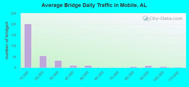
- 5,331,403Total average daily traffic
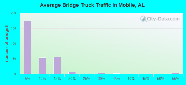
- 449,063Total average daily truck traffic
- National Bridge Inventory (NBI) Registered Bridges for Mobile
- No street view available for this location
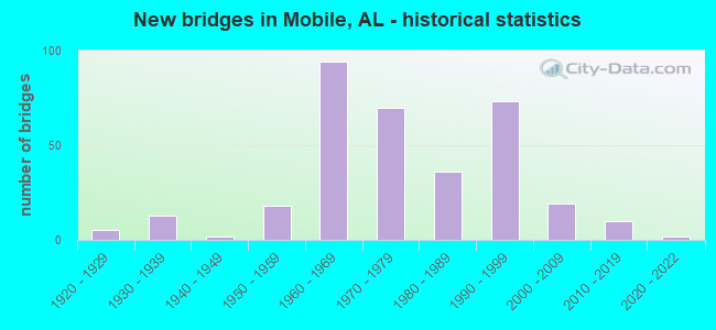
- New bridges - historical statistics
- 51920-1929
- 131930-1939
- 21940-1949
- 181950-1959
- 941960-1969
- 701970-1979
- 361980-1989
- 731990-1999
- 192000-2009
- 102010-2019
- 22020-2022
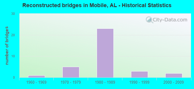
- Reconstructed bridges - Historical Statistics
- 11960-1969
- 51970-1979
- 231980-1989
- 31990-1999
- 22000-2009
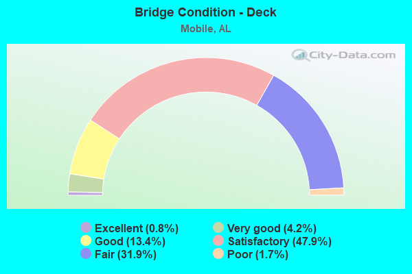
- Bridge Condition - Deck
- 0.8%Excellent
- 4.2%Very good
- 13.4%Good
- 47.9%Satisfactory
- 31.9%Fair
- 1.7%Poor
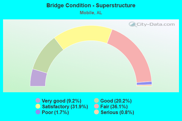
- Bridge Condition - Superstructure
- 9.2%Very good
- 20.2%Good
- 31.9%Satisfactory
- 36.1%Fair
- 1.7%Poor
- 0.8%Serious

- Bridge Condition - Substructure
- 5.0%Very good
- 23.5%Good
- 34.5%Satisfactory
- 32.8%Fair
- 2.5%Poor
- 1.7%Serious
- 0.8%Critical
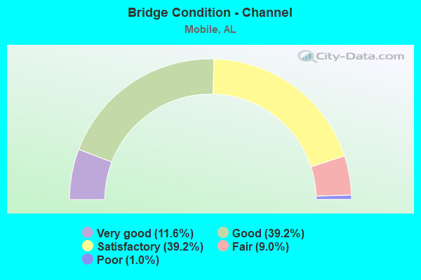
- Bridge Condition - Channel
- 11.6%Very good
- 39.2%Good
- 39.2%Satisfactory
- 9.0%Fair
- 1.0%Poor
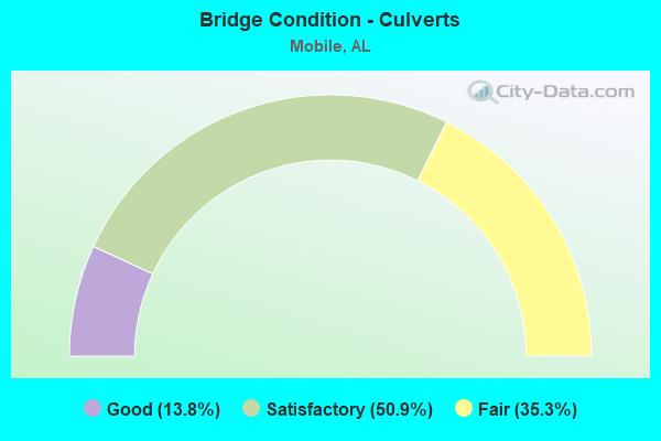
- Bridge Condition - Culverts
- 13.8%Good
- 50.9%Satisfactory
- 35.3%Fair
Find on map >> Show street view
Structure Number: 17173, Location: 0.7 MI S I-10 (Lat: 30.588678, Lng: -88.145239), Route carried "under" structure: ServiceCounty highway , Year Built: 1999, Structure Length: 0. m, Average Daily Traffic: 1,011 (year 2019), Truck Traffic: 25%, Features Intersected: CSX RR / TILLMANS CRN, Facility Carried by Structure: SR 193 SB
Minimum Vertical Clearance: 8.15m (26.74ft), Kilometerpoint: 0.000, Lanes on structure: 2, Lanes under structure: 2, Material/Design: Steel continuous, Design/Construction: Stringer/Multi-beam, Length of Maximum Span: 31.4m (103.0ft)
Find on map >> Show street view
Structure Number: 17173, Location: 0.7 MI S I-10 (Lat: 30.588678, Lng: -88.145239), Route carried "under" structure: ServiceCounty highway , Year Built: 1999, Structure Length: 0. m, Average Daily Traffic: 1,163 (year 2019), Truck Traffic: 8%, Features Intersected: CSX RR / TILLMANS CRN, Facility Carried by Structure: SR 193 SB
Minimum Vertical Clearance: 8.65m (28.38ft), Kilometerpoint: 0.000, Lanes on structure: 2, Lanes under structure: 2, Toll: Toll bridge is a segment, Material/Design: Steel continuous, Design/Construction: Stringer/Multi-beam, Length of Maximum Span: 31.4m (103.0ft)
Find on map >> Show street view
Structure Number: 17197, Location: 200 FT N OF GOVERNMENT ST (Lat: 30.691450, Lng: -88.039017), Route carried "under" structure: Bypass City street , Year Built: 1991, Structure Length: 0. m, Features Intersected: WATER STREET, Facility Carried by Structure: PEDESTRIAN BRIDGE
Minimum Vertical Clearance: 8.00m (26.25ft), Kilometerpoint: 0.000, Lanes under structure: 7, Material/Design: Steel continuous, Design/Construction: Truss - Thru, Length of Maximum Span: 40.0m (131.2ft)