Bridge Statistics for Morehead, Kentucky (KY)
Condition, Traffic, Stress, Structural Evaluation, Project Costs
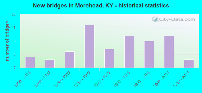
- New bridges - historical statistics
- 41930-1939
- 31940-1949
- 61950-1959
- 161960-1969
- 71970-1979
- 121980-1989
- 101990-1999
- 122000-2009
- 32010-2019
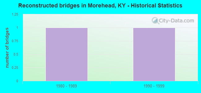
- Reconstructed bridges - Historical Statistics
- 11980-1989
- 11990-1999
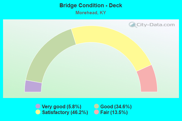
- Bridge Condition - Deck
- 5.8%Very good
- 34.6%Good
- 46.2%Satisfactory
- 13.5%Fair
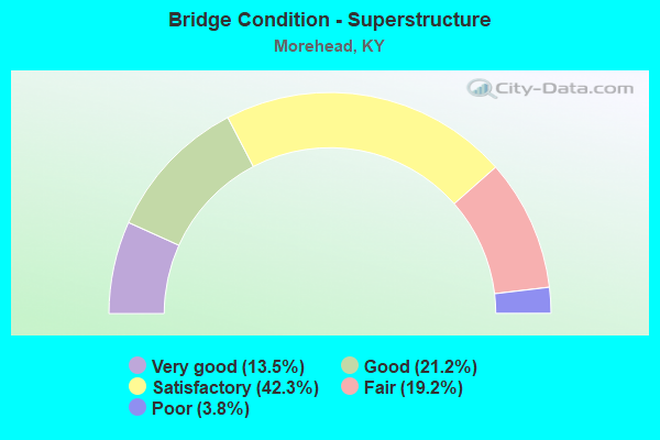
- Bridge Condition - Superstructure
- 13.5%Very good
- 21.2%Good
- 42.3%Satisfactory
- 19.2%Fair
- 3.8%Poor
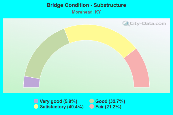
- Bridge Condition - Substructure
- 5.8%Very good
- 32.7%Good
- 40.4%Satisfactory
- 21.2%Fair
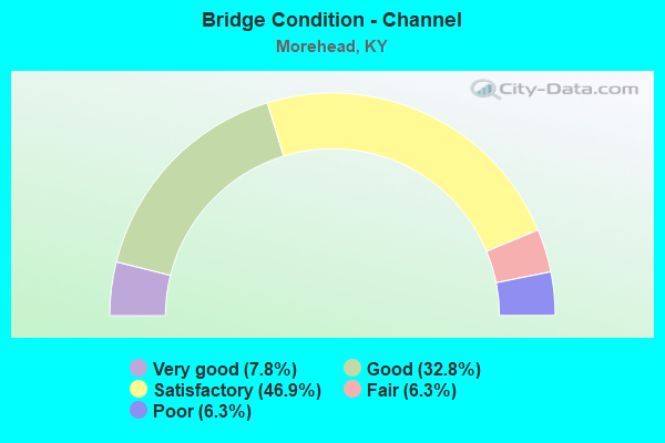
- Bridge Condition - Channel
- 7.8%Very good
- 32.8%Good
- 46.9%Satisfactory
- 6.3%Fair
- 6.3%Poor
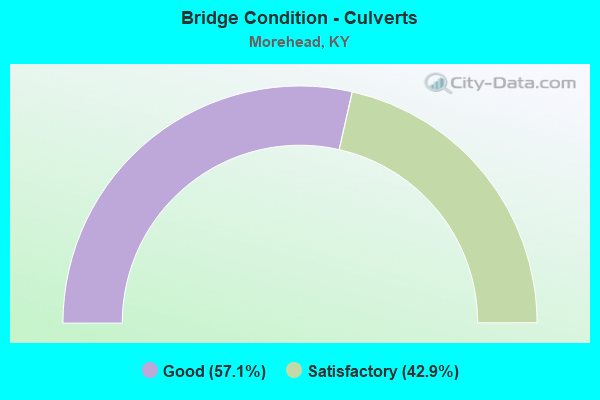
- Bridge Condition - Culverts
- 57.1%Good
- 42.9%Satisfactory
Find on map >> Show street view
Structure Number: 103B00016N, Location: .10 MI S.E. OF JCT US 60 (Lat: 38.196389, Lng: -83.408611), Route carried "on" structure: State highway 32, Year Built: 1951, Status: Posted for load, Structure Length: 4.02m (13.19ft), Average Daily Traffic: 4,877 (year 2018), Truck Traffic: 6%, Average Future Daily Traffic: 4,535 (year 2038), Design Load: H 20, Features Intersected: TRIPLETT CREEK
Minimum Vertical Clearance: 30+ m (98+ ft), Kilometerpoint: 13.864, Lanes on structure: 2, Owner: State Highway Agency, Approaching Roadway Width: 7.3m (24.0ft), Material/Design: Concrete, Design/Construction: Tee Beam, Number Of Spans In Main Unit: 4, Length of Maximum Span: 9.1m (29.9ft), Curb or Sidewalk Widths: Left: 0.2m (0.7ft), Right: 0.2m (0.7ft), Curb-To-Curb Width: 7.3m (24.0ft), Out-to-Out Width: 8.5m (27.9ft)
Condition: Deck: Satisfactory, Superstructure: Good, Substructure: Satisfactory, Channel: Satisfactory, Operating Rating: 58.7 metric tons, Method Used To Determine Operating Rating: Load Factor (LF), Inventory Rating: 35.2 metric tons, Method Used To Determine Inventory Rating: Load Factor (LF), Structural Evaluation: Equal to present minimum criteria, Deck Geometry: High priority of replacement, Waterway Adequacy: Equal to present desirable criteria, Approach Roadway Alignment: Equal to present desirable criteria, Bridge Posting: Required (Relationship of Operating Rating to Maximum Legal Load: 10.0 - 19.9% below), Length Of Structure Improvement: 0.40m (1.31ft), Designated Inspection Frequency: Every 24 months, Inspection Date: May 2020, Bridge Improvement Cost: $421,000, Total Project Cost: $420,000, Deck Structure Type: Concrete Cast-file-Place, Wearing Surface/Protective System: Wearing Surface: Latex Concrete
Find on map >> Show street view
Structure Number: 103B00020N, Location: .10 MI WEST OF JCT KY 32 (Lat: 38.241944, Lng: -83.515278), Route carried "on" structure: State highway 158, Year Built: 1934, Status: Posted for load, Structure Length: 1.07m (3.51ft), Average Daily Traffic: 2,341 (year 2020), Truck Traffic: 5%, Average Future Daily Traffic: 2,060 (year 2040), Design Load: H 15, Features Intersected: LITTLE BRUSHY CREEK
Minimum Vertical Clearance: 30+ m (98+ ft), Kilometerpoint: 4.242, Lanes on structure: 2, Owner: State Highway Agency, Approaching Roadway Width: 5.8m (19.0ft), Skew: 1 degrees, Material/Design: Concrete, Design/Construction: Culvert, Number Of Spans In Main Unit: 3, Length of Maximum Span: 3.0m (9.8ft)
Condition: Channel: Satisfactory, Culverts: Good, Operating Rating: 20.0 metric tons, Method Used To Determine Operating Rating: Field evaluation and documented engineering judgment, Inventory Rating: 20.0 metric tons, Method Used To Determine Inventory Rating: Field evaluation and documented engineering judgment, Structural Evaluation: Somewhat better than minimum adequacy, Waterway Adequacy: Better than present minimum criteria, Approach Roadway Alignment: Equal to present minimum criteria, Bridge Posting: Required (Relationship of Operating Rating to Maximum Legal Load: > 39.9% below), Designated Inspection Frequency: Every 24 months, Inspection Date: May 2020
Find on map >> Show street view
Structure Number: 103B00023N, Location: .62 MI EAST OF JCT KY 32 (Lat: 38.211667, Lng: -83.470278), Route carried "on" structure: State highway 377, Year Built: 1939, Status: Posted for load, Structure Length: 2.62m (8.60ft), Average Daily Traffic: 4,032 (year 2019), Truck Traffic: 8%, Average Future Daily Traffic: 3,548 (year 2039), Design Load: H 15, Features Intersected: BRUSHY CREEK
Minimum Vertical Clearance: 30+ m (98+ ft), Kilometerpoint: 0.933, Lanes on structure: 2, Owner: State Highway Agency, Approaching Roadway Width: 6.4m (21.0ft), Material/Design: Concrete, Design/Construction: Tee Beam, Number Of Spans In Main Unit: 2, Length of Maximum Span: 12.2m (40.0ft), Curb-To-Curb Width: 6.1m (20.0ft), Out-to-Out Width: 7.0m (23.0ft)
Condition: Deck: Fair, Superstructure: Satisfactory, Substructure: Satisfactory, Channel: Satisfactory, Operating Rating: 45.0 metric tons, Method Used To Determine Operating Rating: Load Factor (LF), Inventory Rating: 27.0 metric tons, Method Used To Determine Inventory Rating: Load Factor (LF), Structural Evaluation: Equal to present minimum criteria, Deck Geometry: High priority of replacement, Waterway Adequacy: Equal to present desirable criteria, Approach Roadway Alignment: Better than present minimum criteria, Bridge Posting: Required (Relationship of Operating Rating to Maximum Legal Load: 30.0 - 39.9% below), Length Of Structure Improvement: 0.26m (0.85ft), Designated Inspection Frequency: Every 24 months, Inspection Date: May 2020, Bridge Improvement Cost: $228,000, Total Project Cost: $228,000, Deck Structure Type: Concrete Cast-file-Place, Wearing Surface/Protective System: Wearing Surface: Bituminous, Membrane: Preformed Fabric
Find on map >> Show street view
Structure Number: 103B00024N, Location: 1.9 MI SW OF W-JCT KY 799 (Lat: 38.263889, Lng: -83.434444), Route carried "on" structure: State highway 377, Year Built: 1939, Status: Open, Structure Length: 2.01m (6.59ft), Average Daily Traffic: 2,936 (year 2020), Truck Traffic: 8%, Average Future Daily Traffic: 2,583 (year 2040), Design Load: H 15, Features Intersected: CLEAR CREEK
Minimum Vertical Clearance: 30+ m (98+ ft), Kilometerpoint: 8.163, Lanes on structure: 2, Owner: State Highway Agency, Approaching Roadway Width: 6.4m (21.0ft), Material/Design: Concrete, Design/Construction: Tee Beam, Number Of Spans In Main Unit: 2, Length of Maximum Span: 9.1m (29.9ft), Curb or Sidewalk Widths: Left: 0.2m (0.7ft), Right: 0.2m (0.7ft), Curb-To-Curb Width: 6.1m (20.0ft), Out-to-Out Width: 7.0m (23.0ft)
Condition: Deck: Satisfactory, Superstructure: Satisfactory, Substructure: Fair, Channel: Good, Operating Rating: 64.8 metric tons, Method Used To Determine Operating Rating: Load Factor (LF), Inventory Rating: 38.8 metric tons, Method Used To Determine Inventory Rating: Load Factor (LF), Structural Evaluation: Somewhat better than minimum adequacy, Deck Geometry: High priority of replacement, Waterway Adequacy: Better than present minimum criteria, Approach Roadway Alignment: Better than present minimum criteria, Length Of Structure Improvement: 0.20m (0.66ft), Designated Inspection Frequency: Every 24 months, Inspection Date: May 2020, Bridge Improvement Cost: $173,000, Total Project Cost: $173,000, Deck Structure Type: Concrete Cast-file-Place, Wearing Surface/Protective System: Wearing Surface: Bituminous
Find on map >> Show street view
Structure Number: 103B00026N, Location: 3.2 MI EAST OF JCT KY 32 (Lat: 38.240556, Lng: -83.447500), Route carried "on" structure: State highway 377, Year Built: 1939, Status: Open, Structure Length: 1.19m (3.90ft), Average Daily Traffic: 2,936 (year 2020), Truck Traffic: 8%, Average Future Daily Traffic: 2,583 (year 2040), Features Intersected: POND LICK CREEK
Minimum Vertical Clearance: 30+ m (98+ ft), Kilometerpoint: 5.100, Lanes on structure: 2, Owner: State Highway Agency, Approaching Roadway Width: 6.4m (21.0ft), Skew: 3 degrees, Material/Design: Concrete, Design/Construction: Culvert, Number Of Spans In Main Unit: 3, Length of Maximum Span: 3.0m (9.8ft)
Condition: Channel: Satisfactory, Culverts: Good, Operating Rating: 54.4 metric tons, Method Used To Determine Operating Rating: Field evaluation and documented engineering judgment, Inventory Rating: 39.9 metric tons, Method Used To Determine Inventory Rating: Field evaluation and documented engineering judgment, Structural Evaluation: Better than present minimum criteria, Waterway Adequacy: Equal to present desirable criteria, Approach Roadway Alignment: Better than present minimum criteria, Designated Inspection Frequency: Every 24 months, Inspection Date: May 2020
Find on map >> Show street view
Structure Number: 103B00047N, Location: 2.8 MI EAST OF JCT KY 519 (Lat: 38.156667, Lng: -83.386667), Route carried "on" structure: State highway 1167, Year Built: 1950, Status: Open, Structure Length: 0.79m (2.59ft), Average Daily Traffic: 721 (year 2020), Average Future Daily Traffic: 634 (year 2040), Design Load: H 15, Features Intersected: WALLACE BRANCH, Facility Carried by Structure: DRY CREEK ROAD
Minimum Vertical Clearance: 30+ m (98+ ft), Kilometerpoint: 4.490, Lanes on structure: 2, Owner: State Highway Agency, Approaching Roadway Width: 5.2m (17.1ft), Skew: 3 degrees, Material/Design: Concrete, Design/Construction: Culvert, Number Of Spans In Main Unit: 2, Length of Maximum Span: 3.0m (9.8ft)
Condition: Channel: Satisfactory, Culverts: Good, Operating Rating: 54.4 metric tons, Method Used To Determine Operating Rating: Field evaluation and documented engineering judgment, Inventory Rating: 40.8 metric tons, Method Used To Determine Inventory Rating: Field evaluation and documented engineering judgment, Structural Evaluation: Better than present minimum criteria, Waterway Adequacy: Equal to present desirable criteria, Approach Roadway Alignment: Equal to present minimum criteria, Designated Inspection Frequency: Every 24 months, Inspection Date: June 2020
Find on map >> Show street view
Structure Number: 103B00048N, Location: 3.7 MI EAST OF JCT KY 519 (Lat: 38.155556, Lng: -83.374444), Route carried "on" structure: State highway 1167, Year Built: 1950, Status: Open, Structure Length: 0.70m (2.30ft), Average Daily Traffic: 721 (year 2020), Average Future Daily Traffic: 634 (year 2040), Design Load: H 15, Features Intersected: POSSUM TROT BRANCH, Facility Carried by Structure: DRY CREEK ROAD
Minimum Vertical Clearance: 30+ m (98+ ft), Kilometerpoint: 5.618, Lanes on structure: 2, Owner: State Highway Agency, Approaching Roadway Width: 5.2m (17.1ft), Material/Design: Concrete, Design/Construction: Culvert, Number Of Spans In Main Unit: 2, Length of Maximum Span: 3.0m (9.8ft)
Condition: Channel: Satisfactory, Culverts: Good, Operating Rating: 54.4 metric tons, Method Used To Determine Operating Rating: Field evaluation and documented engineering judgment, Inventory Rating: 39.9 metric tons, Method Used To Determine Inventory Rating: Field evaluation and documented engineering judgment, Structural Evaluation: Better than present minimum criteria, Waterway Adequacy: Equal to present minimum criteria, Approach Roadway Alignment: Meets minimum limits, Designated Inspection Frequency: Every 24 months, Inspection Date: June 2020
Find on map >> Show street view
Structure Number: 103B00049N, Location: 4.1 MI EAST OF JCT KY 519 (Lat: 38.153611, Lng: -83.365556), Route carried "on" structure: State highway 1167, Year Built: 1950, Status: Posted for load, Structure Length: 0.70m (2.30ft), Average Daily Traffic: 721 (year 2020), Average Future Daily Traffic: 634 (year 2040), Design Load: H 15, Features Intersected: DRY CREEK-, Facility Carried by Structure: DRY CREEK ROAD
Minimum Vertical Clearance: 30+ m (98+ ft), Kilometerpoint: 6.437, Lanes on structure: 2, Owner: State Highway Agency, Approaching Roadway Width: 5.2m (17.1ft), Skew: 3 degrees, Material/Design: Concrete, Design/Construction: Culvert, Number Of Spans In Main Unit: 2, Length of Maximum Span: 3.0m (9.8ft)
Condition: Channel: Fair, Culverts: Satisfactory, Operating Rating: 20.0 metric tons, Method Used To Determine Operating Rating: Field evaluation and documented engineering judgment, Inventory Rating: 20.0 metric tons, Method Used To Determine Inventory Rating: Field evaluation and documented engineering judgment, Structural Evaluation: Somewhat better than minimum adequacy, Waterway Adequacy: Equal to present minimum criteria, Approach Roadway Alignment: Better than present minimum criteria, Bridge Posting: Required (Relationship of Operating Rating to Maximum Legal Load: > 39.9% below), Designated Inspection Frequency: Every 24 months, Inspection Date: June 2020
Find on map >> Show street view
Structure Number: 103B00054L, Location: WBL 2.4 MI W OF KY32 NTRC (Lat: 38.186389, Lng: -83.523333), Route carried "on" structure: Interstate 64, Year Built: 1968, Status: Open, Structure Length: 12.95m (42.49ft), Average Daily Traffic: 7,010 (year 2020), Average Future Daily Traffic: 8,552 (year 2040), Design Load: HS 20, Features Intersected: BULL FORK CRK & ROAD
Minimum Vertical Clearance: 30+ m (98+ ft), Kilometerpoint: 216.898, Lanes on structure: 2, Lanes under structure: 2, Base Highway Network: Yes, Owner: State Highway Agency, Approaching Roadway Width: 11.3m (37.1ft), Material/Design: Steel continuous, Design/Construction: Stringer/Multi-beam, Number Of Spans In Main Unit: 3, Length of Maximum Span: 42.7m (140.1ft), Curb-To-Curb Width: 9.9m (32.5ft), Out-to-Out Width: 10.8m (35.4ft)
Condition: Deck: Satisfactory, Superstructure: Fair, Substructure: Fair, Channel: Good, Operating Rating: 64.1 metric tons, Method Used To Determine Operating Rating: Load Factor (LF), Inventory Rating: 38.5 metric tons, Method Used To Determine Inventory Rating: Load Factor (LF), Structural Evaluation: Somewhat better than minimum adequacy, Deck Geometry: Meets minimum limits, Underclear: Better than present minimum criteria, Waterway Adequacy: Equal to present desirable criteria, Approach Roadway Alignment: Equal to present desirable criteria, Length Of Structure Improvement: 1.30m (4.27ft), Designated Inspection Frequency: Every 24 months, Inspection Date: August 2020, Bridge Improvement Cost: $1,806,000, Total Project Cost: $1,806,000, Deck Structure Type: Concrete Cast-file-Place, Wearing Surface/Protective System: Wearing Surface: Integral Concrete
Find on map >> Show street view
Structure Number: 103B00054R, Location: EBL 2.4 MI W OF KY32 NTRC (Lat: 38.186111, Lng: -83.523333), Route carried "on" structure: Interstate 64, Year Built: 1968, Status: Open, Structure Length: 12.95m (42.49ft), Average Daily Traffic: 7,010 (year 2020), Average Future Daily Traffic: 8,552 (year 2040), Design Load: HS 20, Features Intersected: BULL FORK CRK & ROAD
Minimum Vertical Clearance: 30+ m (98+ ft), Kilometerpoint: 216.885, Lanes on structure: 2, Lanes under structure: 2, Base Highway Network: Yes, Owner: State Highway Agency, Approaching Roadway Width: 11.3m (37.1ft), Material/Design: Steel continuous, Design/Construction: Stringer/Multi-beam, Number Of Spans In Main Unit: 3, Length of Maximum Span: 42.7m (140.1ft), Curb-To-Curb Width: 9.9m (32.5ft), Out-to-Out Width: 10.8m (35.4ft)
Condition: Deck: Satisfactory, Superstructure: Satisfactory, Substructure: Fair, Channel: Good, Operating Rating: 64.1 metric tons, Method Used To Determine Operating Rating: Load Factor (LF), Inventory Rating: 38.5 metric tons, Method Used To Determine Inventory Rating: Load Factor (LF), Structural Evaluation: Somewhat better than minimum adequacy, Deck Geometry: Meets minimum limits, Underclear: Better than present minimum criteria, Waterway Adequacy: Equal to present desirable criteria, Approach Roadway Alignment: Equal to present desirable criteria, Length Of Structure Improvement: 1.30m (4.27ft), Designated Inspection Frequency: Every 24 months, Inspection Date: August 2020, Bridge Improvement Cost: $1,806,000, Total Project Cost: $1,806,000, Deck Structure Type: Concrete Cast-file-Place, Wearing Surface/Protective System: Wearing Surface: Integral Concrete
Find on map >> Show street view
Structure Number: 103B00055L, Location: WBL .8 MI W OF KY 32 NTRC (Lat: 38.187778, Lng: -83.494722), Route carried "on" structure: Interstate 64, Year Built: 1968, Status: Open, Structure Length: 12.25m (40.19ft), Average Daily Traffic: 7,010 (year 2020), Average Future Daily Traffic: 8,552 (year 2040), Design Load: HS 20, Features Intersected: CR 5224 + N.FK.TRIPLTT C
Minimum Vertical Clearance: 30+ m (98+ ft), Kilometerpoint: 219.436, Lanes on structure: 2, Lanes under structure: 2, Base Highway Network: Yes, Owner: State Highway Agency, Approaching Roadway Width: 11.3m (37.1ft), Skew: 3 degrees, Material/Design: Concrete continuous, Design/Construction: Tee Beam, Number Of Spans In Main Unit: 3, Number Of Approach Spans: 3, Length of Maximum Span: 30.5m (100.1ft), Curb-To-Curb Width: 9.9m (32.5ft), Out-to-Out Width: 10.8m (35.4ft)
Condition: Deck: Satisfactory, Superstructure: Good, Substructure: Satisfactory, Channel: Satisfactory, Operating Rating: 49.2 metric tons, Method Used To Determine Operating Rating: Load Factor (LF), Inventory Rating: 29.5 metric tons, Method Used To Determine Inventory Rating: Load Factor (LF), Structural Evaluation: Equal to present minimum criteria, Deck Geometry: Meets minimum limits, Underclear: Equal to present minimum criteria, Waterway Adequacy: Equal to present desirable criteria, Approach Roadway Alignment: Equal to present desirable criteria, Length Of Structure Improvement: 1.23m (4.04ft), Designated Inspection Frequency: Every 24 months, Inspection Date: June 2020, Bridge Improvement Cost: $1,708,000, Total Project Cost: $1,708,000, Deck Structure Type: Concrete Cast-file-Place, Wearing Surface/Protective System: Wearing Surface: Latex Concrete
Find on map >> Show street view
Structure Number: 103B00055R, Location: EBL .8 MI W OF KY 32 NTRC (Lat: 38.187500, Lng: -83.494722), Route carried "on" structure: Interstate 64, Year Built: 1968, Status: Open, Structure Length: 12.25m (40.19ft), Average Daily Traffic: 7,010 (year 2020), Average Future Daily Traffic: 8,552 (year 2040), Design Load: HS 20, Features Intersected: CR 5224 + N.FK.TRIPLTT C
Minimum Vertical Clearance: 30+ m (98+ ft), Kilometerpoint: 219.412, Lanes on structure: 2, Lanes under structure: 2, Base Highway Network: Yes, Owner: State Highway Agency, Approaching Roadway Width: 11.3m (37.1ft), Skew: 3 degrees, Material/Design: Concrete continuous, Design/Construction: Tee Beam, Number Of Spans In Main Unit: 3, Number Of Approach Spans: 3, Length of Maximum Span: 30.5m (100.1ft), Curb-To-Curb Width: 9.9m (32.5ft), Out-to-Out Width: 10.8m (35.4ft)
Condition: Deck: Satisfactory, Superstructure: Satisfactory, Substructure: Fair, Channel: Satisfactory, Operating Rating: 49.2 metric tons, Method Used To Determine Operating Rating: Load Factor (LF), Inventory Rating: 29.5 metric tons, Method Used To Determine Inventory Rating: Load Factor (LF), Structural Evaluation: Somewhat better than minimum adequacy, Deck Geometry: Meets minimum limits, Underclear: Equal to present minimum criteria, Waterway Adequacy: Equal to present desirable criteria, Approach Roadway Alignment: Equal to present desirable criteria, Length Of Structure Improvement: 1.23m (4.04ft), Designated Inspection Frequency: Every 24 months, Inspection Date: June 2020, Bridge Improvement Cost: $1,708,000, Total Project Cost: $1,708,000, Deck Structure Type: Concrete Cast-file-Place, Wearing Surface/Protective System: Wearing Surface: Monolithic Concrete
Find on map >> Show street view
Structure Number: 103B00056L, Location: WBL @KY 32-MOREHEAD-NTRCH (Lat: 38.192222, Lng: -83.478611), Route carried "on" structure: Interstate 64, Year Built: 1968, Status: Open, Structure Length: 4.75m (15.58ft), Average Daily Traffic: 4,087 (year 2020), Truck Traffic: 22%, Average Future Daily Traffic: 4,986 (year 2040), Design Load: HS 20, Features Intersected: KY 32
Minimum Vertical Clearance: 30+ m (98+ ft), Kilometerpoint: 220.945, Lanes on structure: 2, Lanes under structure: 4, Base Highway Network: Yes, Owner: State Highway Agency, Approaching Roadway Width: 11.9m (39.0ft), Material/Design: Prestressed concrete, Design/Construction: Stringer/Multi-beam, Number Of Spans In Main Unit: 2, Number Of Approach Spans: 1, Length of Maximum Span: 21.3m (69.9ft), Curb-To-Curb Width: 12.2m (40.0ft), Out-to-Out Width: 13.1m (43.0ft)
Condition: Deck: Satisfactory, Superstructure: Satisfactory, Substructure: Fair, Operating Rating: 68.9 metric tons, Method Used To Determine Operating Rating: Load Factor (LF), Inventory Rating: 41.3 metric tons, Method Used To Determine Inventory Rating: Load Factor (LF), Structural Evaluation: Somewhat better than minimum adequacy, Deck Geometry: Better than present minimum criteria, Underclear: High priority of corrective action, Approach Roadway Alignment: Equal to present desirable criteria, Length Of Structure Improvement: 0.48m (1.57ft), Designated Inspection Frequency: Every 24 months, Inspection Date: June 2020, Bridge Improvement Cost: $753,000, Total Project Cost: $752,000, Deck Structure Type: Concrete Cast-file-Place, Wearing Surface/Protective System: Wearing Surface: Integral Concrete
Find on map >> Show street view
Structure Number: 103B00056R, Location: EBL @KY 32-MOREHEAD-NTRCH (Lat: 38.192222, Lng: -83.478611), Route carried "on" structure: Interstate 64, Year Built: 1968, Status: Open, Structure Length: 4.75m (15.58ft), Average Daily Traffic: 4,087 (year 2020), Truck Traffic: 22%, Average Future Daily Traffic: 4,986 (year 2040), Design Load: HS 20, Features Intersected: KY32
Minimum Vertical Clearance: 30+ m (98+ ft), Kilometerpoint: 220.944, Lanes on structure: 2, Lanes under structure: 4, Base Highway Network: Yes, Owner: State Highway Agency, Approaching Roadway Width: 11.9m (39.0ft), Material/Design: Prestressed concrete, Design/Construction: Stringer/Multi-beam, Number Of Spans In Main Unit: 2, Number Of Approach Spans: 1, Length of Maximum Span: 21.3m (69.9ft), Curb-To-Curb Width: 12.2m (40.0ft), Out-to-Out Width: 13.1m (43.0ft)
Condition: Deck: Fair, Superstructure: Satisfactory, Substructure: Fair, Operating Rating: 68.9 metric tons, Method Used To Determine Operating Rating: Load Factor (LF), Inventory Rating: 41.3 metric tons, Method Used To Determine Inventory Rating: Load Factor (LF), Structural Evaluation: Somewhat better than minimum adequacy, Deck Geometry: Better than present minimum criteria, Underclear: High priority of corrective action, Approach Roadway Alignment: Equal to present desirable criteria, Length Of Structure Improvement: 0.48m (1.57ft), Designated Inspection Frequency: Every 24 months, Inspection Date: June 2020, Bridge Improvement Cost: $753,000, Total Project Cost: $752,000, Deck Structure Type: Concrete Cast-file-Place, Wearing Surface/Protective System: Wearing Surface: Latex Concrete
Find on map >> Show street view
Structure Number: 103B00059N, Location: 1.2 MI N.E. OF JCT KY 32 (Lat: 38.245000, Lng: -83.490000), Route carried "on" structure: State highway 785, Year Built: 1967, Status: Posted for load, Structure Length: 0.88m (2.89ft), Average Daily Traffic: 749 (year 2019), Average Future Daily Traffic: 651 (year 2039), Design Load: H 20, Features Intersected: BIG BRUSHY CREEK
Minimum Vertical Clearance: 30+ m (98+ ft), Kilometerpoint: 2.210, Lanes on structure: 2, Owner: State Highway Agency, Approaching Roadway Width: 4.9m (16.1ft), Material/Design: Prestressed concrete, Design/Construction: Box Beam or Girders - Multiple, Number Of Spans In Main Unit: 1, Length of Maximum Span: 7.9m (25.9ft), Curb-To-Curb Width: 5.9m (19.4ft), Out-to-Out Width: 6.3m (20.7ft)
Condition: Deck: Fair, Superstructure: Satisfactory, Substructure: Satisfactory, Channel: Good, Operating Rating: 34.9 metric tons, Method Used To Determine Operating Rating: Load Factor (LF), Inventory Rating: 21.0 metric tons, Method Used To Determine Inventory Rating: Load Factor (LF), Structural Evaluation: Somewhat better than minimum adequacy, Deck Geometry: High priority of replacement, Waterway Adequacy: Equal to present desirable criteria, Approach Roadway Alignment: Better than present minimum criteria, Bridge Posting: Required (Relationship of Operating Rating to Maximum Legal Load: > 39.9% below), Length Of Structure Improvement: 0.09m (0.30ft), Designated Inspection Frequency: Every 24 months, Inspection Date: May 2020, Bridge Improvement Cost: $75,000, Total Project Cost: $74,000, Deck Structure Type: Concrete Precast Panels, Wearing Surface/Protective System: Wearing Surface: Integral Concrete
Find on map >> Show street view
Structure Number: 103B00064N, Location: .30 MI SOU. OF JCT KY 785 (Lat: 38.222500, Lng: -83.488056), Route carried "on" structure: State highway 32, Year Built: 1973, Status: Open, Structure Length: 2.56m (8.40ft), Average Daily Traffic: 9,908 (year 2018), Truck Traffic: 11%, Average Future Daily Traffic: 8,223 (year 2038), Design Load: HS 20, Features Intersected: LITTLE BRUSHY CREEK
Minimum Vertical Clearance: 30+ m (98+ ft), Kilometerpoint: 4.786, Lanes on structure: 2, Base Highway Network: Yes, Owner: State Highway Agency, Approaching Roadway Width: 7.3m (24.0ft), Skew: 4 degrees, Material/Design: Prestressed concrete, Design/Construction: Box Beam or Girders - Multiple, Number Of Spans In Main Unit: 1, Length of Maximum Span: 23.5m (77.1ft), Curb-To-Curb Width: 10.7m (35.1ft), Out-to-Out Width: 11.2m (36.7ft)
Condition: Deck: Satisfactory, Superstructure: Satisfactory, Substructure: Satisfactory, Channel: Satisfactory, Operating Rating: 79.5 metric tons, Method Used To Determine Operating Rating: Load Factor (LF), Inventory Rating: 47.7 metric tons, Method Used To Determine Inventory Rating: Load Factor (LF), Structural Evaluation: Equal to present minimum criteria, Deck Geometry: Meets minimum limits, Waterway Adequacy: Better than present minimum criteria, Approach Roadway Alignment: Equal to present desirable criteria, Designated Inspection Frequency: Every 24 months, Inspection Date: June 2020, Deck Structure Type: Concrete Precast Panels, Wearing Surface/Protective System: Wearing Surface: Bituminous
Find on map >> Show street view
Structure Number: 103B00071N, Location: .3 MI S OF JCT US 60 (Lat: 38.153611, Lng: -83.455000), Route carried "on" structure: State highway 2342, Year Built: 1984, Status: Open, Structure Length: 5.49m (18.01ft), Average Daily Traffic: 949 (year 2020), Average Future Daily Traffic: 882 (year 2040), Design Load: HS 20, Features Intersected: N FK TRIPLETT CR, Facility Carried by Structure: BALDRIDGE ROAD
Minimum Vertical Clearance: 30+ m (98+ ft), Kilometerpoint: 0.541, Lanes on structure: 2, Owner: State Highway Agency, Approaching Roadway Width: 8.8m (28.9ft), Material/Design: Prestressed concrete continuous, Design/Construction: Stringer/Multi-beam, Number Of Spans In Main Unit: 3, Length of Maximum Span: 27.4m (89.9ft), Curb-To-Curb Width: 8.5m (27.9ft), Out-to-Out Width: 9.5m (31.2ft)
Condition: Deck: Good, Superstructure: Good, Substructure: Good, Channel: Good, Operating Rating: 84.7 metric tons, Method Used To Determine Operating Rating: Load Factor (LF), Inventory Rating: 50.8 metric tons, Method Used To Determine Inventory Rating: Load Factor (LF), Structural Evaluation: Better than present minimum criteria, Deck Geometry: Somewhat better than minimum adequacy, Waterway Adequacy: Better than present minimum criteria, Approach Roadway Alignment: Somewhat better than minimum adequacy, Designated Inspection Frequency: Every 24 months, Inspection Date: June 2020, Deck Structure Type: Concrete Cast-file-Place, Wearing Surface/Protective System: Wearing Surface: Monolithic Concrete
Find on map >> Show street view
Structure Number: 103B00076N, Location: .06 MI W OF JCT KY 799 (Lat: 38.232222, Lng: -83.375000), Route carried "on" structure: US 60, Year Built: 1988, Status: Open, Structure Length: 1.13m (3.71ft), Average Daily Traffic: 5,088 (year 2018), Truck Traffic: 9%, Average Future Daily Traffic: 4,477 (year 2038), Design Load: HS 20, Features Intersected: BIG PERRY CREEK
Minimum Vertical Clearance: 30+ m (98+ ft), Kilometerpoint: 20.535, Lanes on structure: 2, Owner: State Highway Agency, Approaching Roadway Width: 7.3m (24.0ft), Material/Design: Concrete, Design/Construction: Culvert, Number Of Spans In Main Unit: 2, Length of Maximum Span: 5.5m (18.0ft)
Condition: Channel: Poor, Culverts: Good, Operating Rating: 70.9 metric tons, Method Used To Determine Operating Rating: Load Factor (LF), Inventory Rating: 42.5 metric tons, Method Used To Determine Inventory Rating: Load Factor (LF), Structural Evaluation: Better than present minimum criteria, Waterway Adequacy: Equal to present desirable criteria, Approach Roadway Alignment: Equal to present minimum criteria, Designated Inspection Frequency: Every 24 months, Inspection Date: June 2020
Find on map >> Show street view
Structure Number: 103B00077N, Location: .2 MI EAST-JCT KY 799 (Lat: 38.233889, Lng: -83.369444), Route carried "on" structure: US 60, Year Built: 1988, Status: Open, Structure Length: 4.54m (14.90ft), Average Daily Traffic: 5,848 (year 2019), Truck Traffic: 9%, Average Future Daily Traffic: 5,146 (year 2039), Design Load: HS 20, Features Intersected: E.FRK.TRIPLETT CREEK
Minimum Vertical Clearance: 30+ m (98+ ft), Kilometerpoint: 21.057, Lanes on structure: 2, Owner: State Highway Agency, Approaching Roadway Width: 9.1m (29.9ft), Skew: 4 degrees, Material/Design: Prestressed concrete continuous, Design/Construction: Stringer/Multi-beam, Number Of Spans In Main Unit: 3, Length of Maximum Span: 15.2m (49.9ft), Curb-To-Curb Width: 9.1m (29.9ft), Out-to-Out Width: 10.1m (33.1ft)
Condition: Deck: Satisfactory, Superstructure: Very good, Substructure: Good, Channel: Good, Operating Rating: 64.6 metric tons, Method Used To Determine Operating Rating: Load Factor (LF), Inventory Rating: 38.7 metric tons, Method Used To Determine Inventory Rating: Load Factor (LF), Structural Evaluation: Better than present minimum criteria, Deck Geometry: High priority of corrective action, Waterway Adequacy: Equal to present desirable criteria, Approach Roadway Alignment: Better than present minimum criteria, Designated Inspection Frequency: Every 24 months, Inspection Date: June 2020, Deck Structure Type: Concrete Cast-file-Place, Wearing Surface/Protective System: Wearing Surface: Monolithic Concrete
Find on map >> Show street view
Structure Number: 103B00079N, Location: .1 MI.W JCT. KY 519 (Lat: 38.164167, Lng: -83.434167), Route carried "on" structure: State highway 2342, Year Built: 1993, Status: Open, Structure Length: 1.61m (5.28ft), Average Daily Traffic: 2,397 (year 2019), Average Future Daily Traffic: 2,229 (year 2039), Design Load: HS 25 or greater, Features Intersected: Morgan Fork
Minimum Vertical Clearance: 30+ m (98+ ft), Kilometerpoint: 3.053, Lanes on structure: 2, Owner: State Highway Agency, Approaching Roadway Width: 5.2m (17.1ft), Material/Design: Prestressed concrete, Design/Construction: Box Beam or Girders - Multiple, Number Of Spans In Main Unit: 1, Length of Maximum Span: 15.1m (49.5ft), Curb-To-Curb Width: 6.9m (22.6ft), Out-to-Out Width: 7.3m (24.0ft)
Condition: Deck: Satisfactory, Superstructure: Satisfactory, Substructure: Good, Channel: Good, Operating Rating: 91.0 metric tons, Method Used To Determine Operating Rating: Load Factor (LF), Inventory Rating: 54.6 metric tons, Method Used To Determine Inventory Rating: Load Factor (LF), Structural Evaluation: Equal to present minimum criteria, Deck Geometry: High priority of replacement, Waterway Adequacy: Equal to present desirable criteria, Approach Roadway Alignment: Meets minimum limits, Designated Inspection Frequency: Every 24 months, Inspection Date: June 2020, Deck Structure Type: Concrete Precast Panels, Wearing Surface/Protective System: Wearing Surface: Monolithic Concrete
Find on map >> Show street view
Structure Number: 103B00083N, Location: 407'MIE. JCT KY 32 W (Lat: 38.177778, Lng: -83.435278), Route carried "on" structure: US 60, Year Built: 1991, Status: Open, Structure Length: 0.64m (2.10ft), Average Daily Traffic: 15,737 (year 2019), Truck Traffic: 9%, Average Future Daily Traffic: 14,635 (year 2039), Design Load: HS 25 or greater, Features Intersected: OYLEY BRANCH, Facility Carried by Structure: WEST WILKERSON BOU
Minimum Vertical Clearance: 30+ m (98+ ft), Kilometerpoint: 12.369, Lanes on structure: 2, Owner: State Highway Agency, Approaching Roadway Width: 15.5m (50.9ft), Skew: 1 degrees, Material/Design: Concrete, Design/Construction: Culvert, Number Of Spans In Main Unit: 2, Length of Maximum Span: 3.0m (9.8ft)
Condition: Channel: Satisfactory, Culverts: Satisfactory, Operating Rating: 68.0 metric tons, Method Used To Determine Operating Rating: Field evaluation and documented engineering judgment, Inventory Rating: 40.8 metric tons, Method Used To Determine Inventory Rating: Field evaluation and documented engineering judgment, Structural Evaluation: Equal to present minimum criteria, Waterway Adequacy: Equal to present desirable criteria, Approach Roadway Alignment: Equal to present desirable criteria, Designated Inspection Frequency: Every 24 months, Inspection Date: June 2020
Find on map >> Show street view
Structure Number: 103B00084N, Location: 1077 FT W JCT KY 32 W (Lat: 38.174722, Lng: -83.439722), Route carried "on" structure: US 60, Year Built: 1993, Status: Open, Structure Length: 0.67m (2.20ft), Average Daily Traffic: 13,849 (year 2018), Truck Traffic: 9%, Average Future Daily Traffic: 12,879 (year 2038), Features Intersected: TOWN BRANCH
Minimum Vertical Clearance: 30+ m (98+ ft), Kilometerpoint: 11.919, Lanes on structure: 2, Owner: State Highway Agency, Approaching Roadway Width: 15.5m (50.9ft), Skew: 5 degrees, Material/Design: Concrete, Design/Construction: Culvert, Number Of Spans In Main Unit: 1, Length of Maximum Span: 6.7m (22.0ft)
Condition: Channel: Good, Culverts: Good, Operating Rating: 54.4 metric tons, Method Used To Determine Operating Rating: Field evaluation and documented engineering judgment, Inventory Rating: 39.9 metric tons, Method Used To Determine Inventory Rating: Field evaluation and documented engineering judgment, Structural Evaluation: Better than present minimum criteria, Waterway Adequacy: Equal to present desirable criteria, Approach Roadway Alignment: Equal to present desirable criteria, Designated Inspection Frequency: Every 24 months, Inspection Date: June 2020
Find on map >> Show street view
Structure Number: 103B00087N, Location: 1.8 MI S JCT US 60 (Lat: 38.191667, Lng: -83.380000), Route carried "on" structure: State highway 32, Year Built: 1999, Status: Open, Structure Length: 0.85m (2.79ft), Average Daily Traffic: 3,847 (year 2019), Truck Traffic: 6%, Average Future Daily Traffic: 3,385 (year 2039), Design Load: HS 25 or greater, Features Intersected: DEEP FORD BRANCH
Minimum Vertical Clearance: 30+ m (98+ ft), Kilometerpoint: 16.584, Lanes on structure: 2, Owner: State Highway Agency, Approaching Roadway Width: 12.2m (40.0ft), Skew: 1 degrees, Material/Design: Concrete continuous, Design/Construction: Culvert, Number Of Spans In Main Unit: 2, Length of Maximum Span: 8.2m (26.9ft)
Condition: Channel: Very good, Culverts: Satisfactory, Operating Rating: 54.4 metric tons, Method Used To Determine Operating Rating: Field evaluation and documented engineering judgment, Inventory Rating: 39.9 metric tons, Method Used To Determine Inventory Rating: Field evaluation and documented engineering judgment, Structural Evaluation: Equal to present minimum criteria, Waterway Adequacy: Better than present minimum criteria, Approach Roadway Alignment: Better than present minimum criteria, Designated Inspection Frequency: Every 24 months, Inspection Date: May 2020, Deck Structure Type: Concrete Cast-file-Place
Find on map >> Show street view
Structure Number: 103B00088N, Location: 3.3 MI. SO. JCT. US60 (Lat: 38.186389, Lng: -83.353056), Route carried "on" structure: State highway 32, Year Built: 2002, Status: Open, Structure Length: 0.67m (2.20ft), Average Daily Traffic: 3,411 (year 2019), Truck Traffic: 6%, Average Future Daily Traffic: 3,001 (year 2039), Design Load: HS 25 or greater, Features Intersected: OVER PATTYS LICK CREEK
Minimum Vertical Clearance: 30+ m (98+ ft), Kilometerpoint: 19.193, Lanes on structure: 2, Owner: State Highway Agency, Approaching Roadway Width: 6.7m (22.0ft), Skew: 4 degrees, Material/Design: Concrete, Design/Construction: Culvert, Number Of Spans In Main Unit: 1, Length of Maximum Span: 6.1m (20.0ft)
Condition: Channel: Very good, Culverts: Satisfactory, Operating Rating: 45.4 metric tons, Method Used To Determine Operating Rating: Load and Resistance Factor Rating (LRFR) rating reported by rating factor(RF) method using HL-93 loadings, Inventory Rating: 35.0 metric tons, Method Used To Determine Inventory Rating: Load and Resistance Factor Rating (LRFR) rating reported by rating factor(RF) method using HL-93 loadings, Structural Evaluation: Equal to present minimum criteria, Waterway Adequacy: Equal to present desirable criteria, Approach Roadway Alignment: Equal to present desirable criteria, Designated Inspection Frequency: Every 24 months, Inspection Date: May 2020
Find on map >> Show street view
Structure Number: 103B00089N, Location: .05 MI E. OF E-JCT KY 32 (Lat: 38.198889, Lng: -83.410278), Route carried "on" structure: US 60, Year Built: 2002, Status: Open, Structure Length: 2.10m (6.89ft), Average Daily Traffic: 5,649 (year 2020), Truck Traffic: 9%, Average Future Daily Traffic: 5,253 (year 2040), Design Load: HS 25 or greater, Features Intersected: OVER RODBURN BRANCH
Minimum Vertical Clearance: 30+ m (98+ ft), Kilometerpoint: 15.664, Lanes on structure: 2, Owner: State Highway Agency, Approaching Roadway Width: 7.9m (25.9ft), Skew: 3 degrees, Material/Design: Prestressed concrete, Design/Construction: Stringer/Multi-beam, Number Of Spans In Main Unit: 1, Length of Maximum Span: 19.8m (65.0ft), Curb-To-Curb Width: 19.5m (64.0ft), Out-to-Out Width: 20.4m (66.9ft)
Condition: Deck: Good, Superstructure: Very good, Substructure: Good, Channel: Good, Operating Rating: 87.1 metric tons, Method Used To Determine Operating Rating: Load Factor (LF), Inventory Rating: 52.3 metric tons, Method Used To Determine Inventory Rating: Load Factor (LF), Structural Evaluation: Better than present minimum criteria, Deck Geometry: Superior to present desirable criteria, Waterway Adequacy: Equal to present desirable criteria, Approach Roadway Alignment: Equal to present desirable criteria, Designated Inspection Frequency: Every 24 months, Inspection Date: June 2020, Deck Structure Type: Concrete Cast-file-Place, Wearing Surface/Protective System: Wearing Surface: Monolithic Concrete
Find on map >> Show street view
Structure Number: 103B00093N, Location: .50 MI N OF I64 NTRCH (Lat: 38.198333, Lng: -83.480556), Route carried "on" structure: State highway 32, Year Built: 2006, Status: Open, Structure Length: 9.24m (30.31ft), Average Daily Traffic: 19,259 (year 2020), Truck Traffic: 5%, Average Future Daily Traffic: 17,910 (year 2040), Design Load: HS 25 or greater, Features Intersected: NORTH FORKTRIPLETT CREEK
Minimum Vertical Clearance: 30+ m (98+ ft), Kilometerpoint: 8.180, Lanes on structure: 4, Owner: State Highway Agency, Approaching Roadway Width: 23.2m (76.1ft), Skew: 10 degrees, Material/Design: Prestressed concrete continuous, Design/Construction: Stringer/Multi-beam, Number Of Spans In Main Unit: 3, Length of Maximum Span: 39.6m (129.9ft), Curb-To-Curb Width: 23.2m (76.1ft), Out-to-Out Width: 24.1m (79.1ft)
Condition: Deck: Good, Superstructure: Very good, Substructure: Good, Channel: Good, Operating Rating: 72.2 metric tons, Method Used To Determine Operating Rating: Load Factor (LF), Inventory Rating: 43.3 metric tons, Method Used To Determine Inventory Rating: Load Factor (LF), Structural Evaluation: Better than present minimum criteria, Deck Geometry: Superior to present desirable criteria, Waterway Adequacy: Better than present minimum criteria, Approach Roadway Alignment: Equal to present desirable criteria, Designated Inspection Frequency: Every 24 months, Inspection Date: June 2020, Deck Structure Type: Concrete Cast-file-Place, Wearing Surface/Protective System: Wearing Surface: Monolithic Concrete, Deck Protection: Epoxy Coated Reinforcing
Find on map >> Show street view
Structure Number: 103B00094N, Location: 1.86 mi S of Jct US 60 (Lat: 38.148611, Lng: -83.419167), Route carried "on" structure: State highway 519, Year Built: 2008, Status: Open, Structure Length: 1.82m (5.97ft), Average Daily Traffic: 3,596 (year 2020), Truck Traffic: 20%, Average Future Daily Traffic: 3,344 (year 2040), Design Load: HS 25 or greater, Features Intersected: MORGAN FORK
Minimum Vertical Clearance: 30.18m (99.02ft), Kilometerpoint: 13.100, Lanes on structure: 2, Owner: State Highway Agency, Approaching Roadway Width: 14.0m (45.9ft), Skew: 4 degrees, Material/Design: Prestressed concrete, Design/Construction: Stringer/Multi-beam, Number Of Spans In Main Unit: 1, Length of Maximum Span: 16.0m (52.5ft), Curb-To-Curb Width: 15.9m (52.2ft), Out-to-Out Width: 16.8m (55.1ft)
Condition: Deck: Good, Superstructure: Very good, Substructure: Good, Channel: Very good, Operating Rating: 84.2 metric tons, Method Used To Determine Operating Rating: Load Factor (LF), Inventory Rating: 46.7 metric tons, Method Used To Determine Inventory Rating: Load Factor (LF), Structural Evaluation: Better than present minimum criteria, Deck Geometry: Superior to present desirable criteria, Waterway Adequacy: Better than present minimum criteria, Approach Roadway Alignment: Equal to present desirable criteria, Designated Inspection Frequency: Every 24 months, Inspection Date: June 2020, Deck Structure Type: Concrete Cast-file-Place, Wearing Surface/Protective System: Wearing Surface: Monolithic Concrete, Deck Protection: Epoxy Coated Reinforcing
Find on map >> Show street view
Structure Number: 103B00095N, Location: .3 MI S. OF JCT. US 60 (Lat: 38.166944, Lng: -83.436111), Route carried "on" structure: State highway 519, Year Built: 2008, Status: Open, Structure Length: 7.65m (25.10ft), Average Daily Traffic: 11,475 (year 2019), Truck Traffic: 20%, Average Future Daily Traffic: 10,671 (year 2039), Design Load: HS 25 or greater, Features Intersected: TRIPLETT CREEK
Minimum Vertical Clearance: 30+ m (98+ ft), Kilometerpoint: 15.665, Lanes on structure: 2, Owner: State Highway Agency, Approaching Roadway Width: 14.0m (45.9ft), Material/Design: Prestressed concrete continuous, Design/Construction: Stringer/Multi-beam, Number Of Spans In Main Unit: 3, Length of Maximum Span: 29.3m (96.1ft), Curb-To-Curb Width: 15.9m (52.2ft), Out-to-Out Width: 16.8m (55.1ft)
Condition: Deck: Very good, Superstructure: Good, Substructure: Very good, Channel: Very good, Operating Rating: 79.0 metric tons, Method Used To Determine Operating Rating: Load Factor (LF), Inventory Rating: 47.4 metric tons, Method Used To Determine Inventory Rating: Load Factor (LF), Structural Evaluation: Better than present minimum criteria, Deck Geometry: Superior to present desirable criteria, Waterway Adequacy: Better than present minimum criteria, Approach Roadway Alignment: Better than present minimum criteria, Designated Inspection Frequency: Every 24 months, Inspection Date: June 2020, Deck Structure Type: Concrete Cast-file-Place, Wearing Surface/Protective System: Wearing Surface: Monolithic Concrete, Deck Protection: Epoxy Coated Reinforcing
Find on map >> Show street view
Structure Number: 103B00096N, Location: @ JCT. KY 1167 (Lat: 38.163611, Lng: -83.430556), Route carried "on" structure: State highway 519, Year Built: 2009, Status: Open, Structure Length: 2.99m (9.81ft), Average Daily Traffic: 3,596 (year 2020), Truck Traffic: 20%, Average Future Daily Traffic: 3,344 (year 2040), Design Load: HS 25 or greater, Features Intersected: DRY CREEK
Minimum Vertical Clearance: 30+ m (98+ ft), Kilometerpoint: 15.022, Lanes on structure: 2, Owner: State Highway Agency, Approaching Roadway Width: 17.1m (56.1ft), Skew: 3 degrees, Material/Design: Prestressed concrete, Design/Construction: Box Beam or Girders - Single/Spread, Number Of Spans In Main Unit: 2, Length of Maximum Span: 14.5m (47.6ft), Curb-To-Curb Width: 15.9m (52.2ft), Out-to-Out Width: 16.8m (55.1ft)
Condition: Deck: Good, Superstructure: Very good, Substructure: Very good, Channel: Good, Operating Rating: 63.7 metric tons, Method Used To Determine Operating Rating: Load Factor (LF), Inventory Rating: 38.2 metric tons, Method Used To Determine Inventory Rating: Load Factor (LF), Structural Evaluation: Equal to present desirable criteria, Deck Geometry: Superior to present desirable criteria, Waterway Adequacy: Equal to present desirable criteria, Approach Roadway Alignment: Equal to present desirable criteria, Designated Inspection Frequency: Every 24 months, Inspection Date: June 2020, Deck Structure Type: Concrete Cast-file-Place, Wearing Surface/Protective System: Wearing Surface: Integral Concrete
Find on map >> Show street view
Structure Number: 103B00097N, Location: 95' SW OF JCT.US 60 (Lat: 38.223333, Lng: -83.381944), Route carried "on" structure: State lands road 8100, Year Built: 1988, Status: Open, Structure Length: 4.72m (15.49ft), Average Daily Traffic: 50 (year 2011), Average Future Daily Traffic: 50 (year 2031), Design Load: HS 20, Features Intersected: TRIPLETT CREEK, Facility Carried by Structure: MSU GOLF ROAD
Minimum Vertical Clearance: 30+ m (98+ ft), Kilometerpoint: 0.060, Lanes on structure: 1, Owner: State Agenciy, Approaching Roadway Width: 4.3m (14.1ft), Skew: 2 degrees, Material/Design: Prestressed concrete, Design/Construction: Box Beam or Girders - Multiple, Number Of Spans In Main Unit: 3, Length of Maximum Span: 22.8m (74.8ft), Curb-To-Curb Width: 3.3m (10.8ft), Out-to-Out Width: 3.7m (12.1ft)
Condition: Deck: Good, Superstructure: Good, Substructure: Good, Channel: Satisfactory, Operating Rating: 71.3 metric tons, Method Used To Determine Operating Rating: Load Factor (LF), Inventory Rating: 42.8 metric tons, Method Used To Determine Inventory Rating: Load Factor (LF), Structural Evaluation: Better than present minimum criteria, Deck Geometry: High priority of replacement, Waterway Adequacy: Better than present minimum criteria, Approach Roadway Alignment: Equal to present minimum criteria, Designated Inspection Frequency: Every 24 months, Inspection Date: June 2020, Deck Structure Type: Concrete Precast Panels, Wearing Surface/Protective System: Wearing Surface: Integral Concrete
Find on map >> Show street view
Structure Number: 103B00098N, Location: 1000' N. OF JCT US 60 (Lat: 38.188889, Lng: -83.431667), Route carried "on" structure: Bypass State lands road 8100, Year Built: 2010, Status: Open, Structure Length: 0.69m (2.26ft), Average Daily Traffic: 250 (year 2012), Average Future Daily Traffic: 2,032 (year 2032), Features Intersected: EVANS BRANCH, Facility Carried by Structure: UNIVERSITY BLVD.
Minimum Vertical Clearance: 30+ m (98+ ft), Kilometerpoint: 0.328, Lanes on structure: 1, Owner: State Agenciy, Approaching Roadway Width: 12.5m (41.0ft), Skew: 4 degrees, Material/Design: Concrete, Design/Construction: Culvert, Number Of Spans In Main Unit: 2, Length of Maximum Span: 2.4m (7.9ft), Curb or Sidewalk Widths: Left: 1.2m (3.9ft), Right: 1.2m (3.9ft)
Condition: Channel: Very good, Culverts: Good, Operating Rating: 54.4 metric tons, Method Used To Determine Operating Rating: Field evaluation and documented engineering judgment, Inventory Rating: 40.8 metric tons, Method Used To Determine Inventory Rating: Field evaluation and documented engineering judgment, Structural Evaluation: Better than present minimum criteria, Waterway Adequacy: Equal to present desirable criteria, Approach Roadway Alignment: Better than present minimum criteria, Designated Inspection Frequency: Every 24 months, Inspection Date: June 2020
Find on map >> Show street view
Structure Number: 103C00004N, Location: .1 MI S OF JCT KY 32 (Lat: 38.185278, Lng: -83.324722), Route carried "on" structure: County highway 1009, Year Built: 1970, Status: Posted for load, Structure Length: 1.49m (4.89ft), Average Daily Traffic: 176 (year 2009), Average Future Daily Traffic: 153 (year 2029), Features Intersected: CHRISTY CREEK, Facility Carried by Structure: VETERANS LN
Minimum Vertical Clearance: 30+ m (98+ ft), Kilometerpoint: 0.343, Lanes on structure: 1, Owner: County Highway Agency, Approaching Roadway Width: 4.0m (13.1ft), Material/Design: Prestressed concrete, Design/Construction: Box Beam or Girders - Multiple, Number Of Spans In Main Unit: 2, Length of Maximum Span: 7.0m (23.0ft), Curb-To-Curb Width: 3.6m (11.8ft), Out-to-Out Width: 3.7m (12.1ft)
Condition: Deck: Fair, Superstructure: Fair, Substructure: Satisfactory, Channel: Satisfactory, Operating Rating: 16.3 metric tons, Method Used To Determine Operating Rating: Field evaluation and documented engineering judgment, Inventory Rating: 16.3 metric tons, Method Used To Determine Inventory Rating: Field evaluation and documented engineering judgment, Structural Evaluation: Somewhat better than minimum adequacy, Deck Geometry: High priority of replacement, Waterway Adequacy: Equal to present desirable criteria, Approach Roadway Alignment: Equal to present minimum criteria, Bridge Posting: Required (Relationship of Operating Rating to Maximum Legal Load: > 39.9% below), Designated Inspection Frequency: Every 24 months, Inspection Date: May 2020, Deck Structure Type: Concrete Precast Panels, Wearing Surface/Protective System: Wearing Surface: Bituminous
Find on map >> Show street view
Structure Number: 103C00019N, Location: .1 MI S OF JCT KY 1167 (Lat: 38.154444, Lng: -83.394722), Route carried "on" structure: County highway 1103, Year Built: 1970, Status: Posted for load, Structure Length: 1.39m (4.56ft), Average Daily Traffic: 738 (year 2009), Average Future Daily Traffic: 642 (year 2029), Features Intersected: DRY CREEK, Facility Carried by Structure: NICHOLS BR
Minimum Vertical Clearance: 30+ m (98+ ft), Kilometerpoint: 0.042, Lanes on structure: 2, Owner: County Highway Agency, Approaching Roadway Width: 7.3m (24.0ft), Material/Design: Steel, Design/Construction: Stringer/Multi-beam, Number Of Spans In Main Unit: 1, Length of Maximum Span: 13.0m (42.7ft), Curb or Sidewalk Widths: Left: 0.2m (0.7ft), Right: 0.2m (0.7ft), Curb-To-Curb Width: 7.5m (24.6ft), Out-to-Out Width: 8.0m (26.2ft)
Condition: Deck: Good, Superstructure: Satisfactory, Substructure: Satisfactory, Channel: Good, Operating Rating: 16.3 metric tons, Method Used To Determine Operating Rating: Field evaluation and documented engineering judgment, Inventory Rating: 16.3 metric tons, Method Used To Determine Inventory Rating: Field evaluation and documented engineering judgment, Structural Evaluation: Meets minimum limits, Deck Geometry: Meets minimum limits, Waterway Adequacy: Equal to present desirable criteria, Approach Roadway Alignment: Equal to present minimum criteria, Bridge Posting: Required (Relationship of Operating Rating to Maximum Legal Load: > 39.9% below), Length Of Structure Improvement: 0.14m (0.46ft), Designated Inspection Frequency: Every 24 months, Inspection Date: April 2020, Bridge Improvement Cost: $68,000, Total Project Cost: $68,000, Deck Structure Type: Concrete Cast-file-Place, Wearing Surface/Protective System: Wearing Surface: Monolithic Concrete
Find on map >> Show street view
Structure Number: 103C00020N, Location: .25 MI S OF JCT KY 1167 (Lat: 38.155278, Lng: -83.378611), Route carried "on" structure: County highway 1104, Year Built: 1950, Status: Posted for load, Structure Length: 1.16m (3.81ft), Average Daily Traffic: 165 (year 2009), Average Future Daily Traffic: 143 (year 2029), Features Intersected: RIDDLE BRANCH, Facility Carried by Structure: RIDDLE FORK RD
Minimum Vertical Clearance: 30+ m (98+ ft), Kilometerpoint: 0.043, Lanes on structure: 1, Owner: County Highway Agency, Approaching Roadway Width: 3.7m (12.1ft), Skew: 1 degrees, Material/Design: Steel, Design/Construction: Stringer/Multi-beam, Number Of Spans In Main Unit: 2, Length of Maximum Span: 5.2m (17.1ft), Curb or Sidewalk Widths: Left: 0.2m (0.7ft), Right: 0.2m (0.7ft), Curb-To-Curb Width: 4.7m (15.4ft), Out-to-Out Width: 4.9m (16.1ft)
Condition: Deck: Satisfactory, Superstructure: Satisfactory, Substructure: Satisfactory, Channel: Satisfactory, Operating Rating: 31.4 metric tons, Method Used To Determine Operating Rating: Load Factor (LF), Inventory Rating: 18.9 metric tons, Method Used To Determine Inventory Rating: Load Factor (LF), Structural Evaluation: Somewhat better than minimum adequacy, Deck Geometry: High priority of replacement, Waterway Adequacy: Equal to present minimum criteria, Approach Roadway Alignment: Equal to present desirable criteria, Bridge Posting: Required (Relationship of Operating Rating to Maximum Legal Load: > 39.9% below), Length Of Structure Improvement: 0.12m (0.39ft), Designated Inspection Frequency: Every 12 months, Inspection Date: April 2021, Bridge Improvement Cost: $67,000, Total Project Cost: $67,000, Deck Structure Type: Concrete Cast-file-Place, Wearing Surface/Protective System: Wearing Surface: Monolithic Concrete
Find on map >> Show street view
Structure Number: 103C00030N, Location: .2 MI S OF JCT US 60 (Lat: 38.183611, Lng: -83.430000), Route carried "on" structure: City street 1164, Year Built: 1976, Status: Open, Structure Length: 8.60m (28.22ft), Average Daily Traffic: 988 (year 2006), Average Future Daily Traffic: 1,592 (year 2026), Design Load: HS 20, Features Intersected: TRIPLETT CREEK, Facility Carried by Structure: BRIDGE ST
Minimum Vertical Clearance: 30+ m (98+ ft), Kilometerpoint: 0.314, Lanes on structure: 2, Owner: City or Municipal Highway Agency, Approaching Roadway Width: 7.3m (24.0ft), Material/Design: Prestressed concrete, Design/Construction: Stringer/Multi-beam, Number Of Spans In Main Unit: 4, Length of Maximum Span: 21.0m (68.9ft), Curb-To-Curb Width: 7.4m (24.3ft), Out-to-Out Width: 8.6m (28.2ft)
Condition: Deck: Good, Superstructure: Good, Substructure: Good, Channel: Good, Operating Rating: 90.4 metric tons, Method Used To Determine Operating Rating: Load Factor (LF), Inventory Rating: 54.2 metric tons, Method Used To Determine Inventory Rating: Load Factor (LF), Structural Evaluation: Better than present minimum criteria, Deck Geometry: Meets minimum limits, Waterway Adequacy: Equal to present desirable criteria, Approach Roadway Alignment: Better than present minimum criteria, Designated Inspection Frequency: Every 24 months, Underwater Inspection Frequency: Every 60 months, Inspection Date: April 2020, Underwater Inspection Date: June 2020, Deck Structure Type: Concrete Cast-file-Place, Wearing Surface/Protective System: Wearing Surface: Monolithic Concrete
Find on map >> Show street view
Structure Number: 103C00031N, Location: 0.1 MI. SOU. KY 377 (Lat: 38.246389, Lng: -83.437500), Route carried "on" structure: County highway 1310, Year Built: 1981, Status: Open, Structure Length: 2.01m (6.59ft), Average Daily Traffic: 67 (year 2009), Average Future Daily Traffic: 58 (year 2029), Features Intersected: N.FK. TRIPLETT CREEK, Facility Carried by Structure: OLD SPORTSMAN RD
Minimum Vertical Clearance: 30+ m (98+ ft), Kilometerpoint: 0.248, Lanes on structure: 1, Owner: County Highway Agency, Approaching Roadway Width: 4.0m (13.1ft), Material/Design: Steel, Design/Construction: Stringer/Multi-beam, Number Of Spans In Main Unit: 2, Length of Maximum Span: 9.4m (30.8ft), Curb or Sidewalk Widths: Left: 0.2m (0.7ft), Right: 0.2m (0.7ft), Curb-To-Curb Width: 3.9m (12.8ft), Out-to-Out Width: 4.3m (14.1ft)
Condition: Deck: Satisfactory, Superstructure: Satisfactory, Substructure: Satisfactory, Channel: Satisfactory, Operating Rating: 57.1 metric tons, Method Used To Determine Operating Rating: Load Factor (LF), Inventory Rating: 34.2 metric tons, Method Used To Determine Inventory Rating: Load Factor (LF), Structural Evaluation: Equal to present minimum criteria, Deck Geometry: Meets minimum limits, Waterway Adequacy: Better than present minimum criteria, Approach Roadway Alignment: Meets minimum limits, Designated Inspection Frequency: Every 24 months, Underwater Inspection Frequency: Every 60 months, Inspection Date: April 2020, Underwater Inspection Date: June 2020, Deck Structure Type: Concrete Cast-file-Place, Wearing Surface/Protective System: Wearing Surface: Monolithic Concrete
Find on map >> Show street view
Structure Number: 103C00035N, Location: .05 MI SE OF JCT KY 377 (Lat: 38.209167, Lng: -83.467500), Route carried "on" structure: County highway 1317, Year Built: 1950, Status: Posted for load, Structure Length: 2.71m (8.89ft), Average Daily Traffic: 78 (year 2009), Average Future Daily Traffic: 67 (year 2029), Features Intersected: N.FK. TRIPLETT CREEK, Facility Carried by Structure: CIMARRON RD
Minimum Vertical Clearance: 30+ m (98+ ft), Kilometerpoint: 0.179, Lanes on structure: 1, Owner: County Highway Agency, Approaching Roadway Width: 3.4m (11.2ft), Material/Design: Steel, Design/Construction: Stringer/Multi-beam, Number Of Spans In Main Unit: 3, Length of Maximum Span: 9.8m (32.2ft), Curb or Sidewalk Widths: Left: 0.2m (0.7ft), Right: 0.2m (0.7ft), Curb-To-Curb Width: 3.4m (11.2ft), Out-to-Out Width: 3.7m (12.1ft)
Condition: Deck: Satisfactory, Superstructure: Fair, Substructure: Fair, Channel: Poor, Operating Rating: 11.6 metric tons, Method Used To Determine Operating Rating: Load Factor (LF), Inventory Rating: 7.0 metric tons, Method Used To Determine Inventory Rating: Load Factor (LF), Structural Evaluation: High priority of replacement, Deck Geometry: High priority of corrective action, Waterway Adequacy: Better than present minimum criteria, Approach Roadway Alignment: Equal to present minimum criteria, Bridge Posting: Required (Relationship of Operating Rating to Maximum Legal Load: > 39.9% below), Length Of Structure Improvement: 0.27m (0.89ft), Designated Inspection Frequency: Every 12 months, Inspection Date: May 2021, Bridge Improvement Cost: $163,000, Total Project Cost: $162,000, Deck Structure Type: Concrete Cast-file-Place, Wearing Surface/Protective System: Wearing Surface: Monolithic Concrete
Find on map >> Show street view
Structure Number: 103C00039N, Location: NE @ JCT KY 32 (Lat: 38.219167, Lng: -83.484444), Route carried "on" structure: County highway 1332, Year Built: 1940, Status: Posted for load, Structure Length: 0.91m (2.99ft), Average Daily Traffic: 346 (year 2009), Average Future Daily Traffic: 301 (year 2029), Features Intersected: BIG BRUSHY CREEK, Facility Carried by Structure: PENNINGTON FLAT RD
Minimum Vertical Clearance: 30+ m (98+ ft), Kilometerpoint: 0.058, Lanes on structure: 2, Owner: County Highway Agency, Approaching Roadway Width: 7.3m (24.0ft), Material/Design: Steel, Design/Construction: Stringer/Multi-beam, Number Of Spans In Main Unit: 2, Length of Maximum Span: 5.5m (18.0ft), Curb or Sidewalk Widths: Left: 0.2m (0.7ft), Right: 0.2m (0.7ft), Curb-To-Curb Width: 7.6m (24.9ft), Out-to-Out Width: 7.9m (25.9ft)
Condition: Deck: Satisfactory, Superstructure: Satisfactory, Substructure: Satisfactory, Channel: Satisfactory, Operating Rating: 50.7 metric tons, Method Used To Determine Operating Rating: Load Factor (LF), Inventory Rating: 30.4 metric tons, Method Used To Determine Inventory Rating: Load Factor (LF), Structural Evaluation: Equal to present minimum criteria, Deck Geometry: Somewhat better than minimum adequacy, Waterway Adequacy: Equal to present desirable criteria, Approach Roadway Alignment: Equal to present minimum criteria, Bridge Posting: Required (Relationship of Operating Rating to Maximum Legal Load: 30.0 - 39.9% below), Designated Inspection Frequency: Every 24 months, Inspection Date: April 2020, Deck Structure Type: Concrete Cast-file-Place, Wearing Surface/Protective System: Wearing Surface: Bituminous
Find on map >> Show street view
Structure Number: 103C00041N, Location: .1 MI N OF N-TERM KY 785 (Lat: 38.258611, Lng: -83.492500), Route carried "on" structure: County highway 1336, Year Built: 1960, Status: Open, Structure Length: 0.79m (2.59ft), Average Daily Traffic: 127 (year 2009), Average Future Daily Traffic: 110 (year 2029), Features Intersected: BIG BRUSHY CREEK, Facility Carried by Structure: BIG BRUSHY RD
Minimum Vertical Clearance: 30+ m (98+ ft), Kilometerpoint: 0.233, Lanes on structure: 1, Owner: County Highway Agency, Approaching Roadway Width: 4.0m (13.1ft), Skew: 1 degrees, Material/Design: Steel, Design/Construction: Stringer/Multi-beam, Number Of Spans In Main Unit: 1, Length of Maximum Span: 6.9m (22.6ft), Curb or Sidewalk Widths: Left: 0.2m (0.7ft), Right: 0.2m (0.7ft), Curb-To-Curb Width: 3.9m (12.8ft), Out-to-Out Width: 4.2m (13.8ft)
Condition: Deck: Good, Superstructure: Fair, Substructure: Satisfactory, Channel: Fair, Operating Rating: 68.4 metric tons, Method Used To Determine Operating Rating: Load Factor (LF), Inventory Rating: 41.1 metric tons, Method Used To Determine Inventory Rating: Load Factor (LF), Structural Evaluation: Somewhat better than minimum adequacy, Deck Geometry: High priority of replacement, Waterway Adequacy: Better than present minimum criteria, Approach Roadway Alignment: Meets minimum limits, Designated Inspection Frequency: Every 24 months, Inspection Date: April 2020, Deck Structure Type: Concrete Cast-file-Place, Wearing Surface/Protective System: Wearing Surface: Bituminous
Find on map >> Show street view
Structure Number: 103C00042N, Location: 2.6 MI W -KY 32 (Lat: 38.189167, Lng: -83.502500), Route carried "on" structure: County highway 1391, Year Built: 1979, Status: Posted for load, Structure Length: 1.25m (4.10ft), Average Daily Traffic: 503 (year 2009), Average Future Daily Traffic: 437 (year 2029), Features Intersected: BRATTON BRANCH, Facility Carried by Structure: BRATTON BR
Minimum Vertical Clearance: 30+ m (98+ ft), Kilometerpoint: 2.285, Lanes on structure: 2, Owner: County Highway Agency, Approaching Roadway Width: 6.7m (22.0ft), Skew: 2 degrees, Material/Design: Steel, Design/Construction: Stringer/Multi-beam, Number Of Spans In Main Unit: 1, Length of Maximum Span: 11.6m (38.1ft), Curb or Sidewalk Widths: Left: 0.2m (0.7ft), Right: 0.2m (0.7ft), Curb-To-Curb Width: 7.9m (25.9ft), Out-to-Out Width: 8.8m (28.9ft)
Condition: Deck: Fair, Superstructure: Fair, Substructure: Satisfactory, Channel: Good, Operating Rating: 31.1 metric tons, Method Used To Determine Operating Rating: Load Factor (LF), Inventory Rating: 18.7 metric tons, Method Used To Determine Inventory Rating: Load Factor (LF), Structural Evaluation: Somewhat better than minimum adequacy, Deck Geometry: Somewhat better than minimum adequacy, Waterway Adequacy: Equal to present desirable criteria, Approach Roadway Alignment: Meets minimum limits, Bridge Posting: Required (Relationship of Operating Rating to Maximum Legal Load: > 39.9% below), Designated Inspection Frequency: Every 24 months, Inspection Date: April 2020, Deck Structure Type: Concrete Cast-file-Place, Wearing Surface/Protective System: Wearing Surface: Bituminous
Find on map >> Show street view
Structure Number: 103C00043N, Location: 400' E OF FLEMING AVE (Lat: 38.180278, Lng: -83.438333), Route carried "on" structure: City street 1132, Year Built: 1960, Status: Posted for load, Structure Length: 0.67m (2.20ft), Average Daily Traffic: 250 (year 2009), Average Future Daily Traffic: 235 (year 2029), Features Intersected: OXLEY BRANCH, Facility Carried by Structure: SUN ST
Minimum Vertical Clearance: 30+ m (98+ ft), Kilometerpoint: 0.177, Lanes on structure: 1, Owner: City or Municipal Highway Agency, Approaching Roadway Width: 4.9m (16.1ft), Skew: 4 degrees, Material/Design: Concrete, Design/Construction: Slab, Number Of Spans In Main Unit: 1, Length of Maximum Span: 6.1m (20.0ft), Curb-To-Curb Width: 4.7m (15.4ft), Out-to-Out Width: 6.3m (20.7ft)
Condition: Deck: Satisfactory, Superstructure: Satisfactory, Substructure: Satisfactory, Channel: Satisfactory, Operating Rating: 16.3 metric tons, Method Used To Determine Operating Rating: Field evaluation and documented engineering judgment, Inventory Rating: 16.3 metric tons, Method Used To Determine Inventory Rating: Field evaluation and documented engineering judgment, Structural Evaluation: Somewhat better than minimum adequacy, Deck Geometry: High priority of replacement, Waterway Adequacy: Equal to present desirable criteria, Approach Roadway Alignment: Somewhat better than minimum adequacy, Bridge Posting: Required (Relationship of Operating Rating to Maximum Legal Load: > 39.9% below), Length Of Structure Improvement: 0.07m (0.23ft), Designated Inspection Frequency: Every 24 months, Inspection Date: April 2020, Bridge Improvement Cost: $58,000, Total Project Cost: $57,000, Deck Structure Type: Concrete Cast-file-Place, Wearing Surface/Protective System: Wearing Surface: Bituminous