Bridge Statistics for Morehead, Kentucky (KY)
Condition, Traffic, Stress, Structural Evaluation, Project Costs
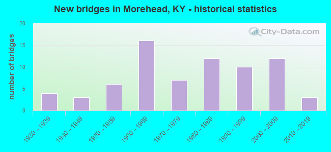
- New bridges - historical statistics
- 41930-1939
- 31940-1949
- 61950-1959
- 161960-1969
- 71970-1979
- 121980-1989
- 101990-1999
- 122000-2009
- 32010-2019
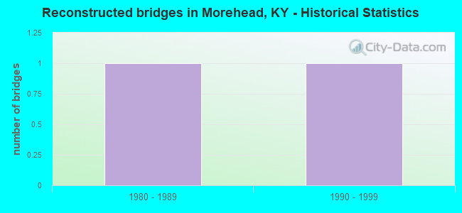
- Reconstructed bridges - Historical Statistics
- 11980-1989
- 11990-1999
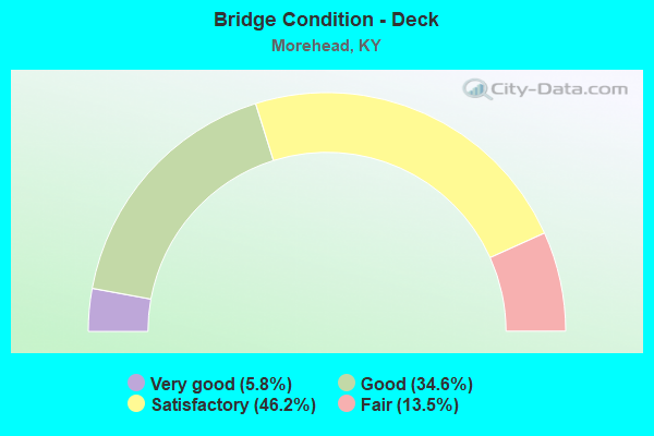
- Bridge Condition - Deck
- 5.8%Very good
- 34.6%Good
- 46.2%Satisfactory
- 13.5%Fair
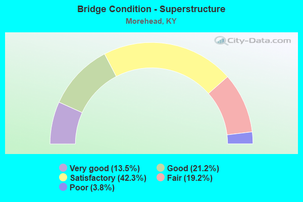
- Bridge Condition - Superstructure
- 13.5%Very good
- 21.2%Good
- 42.3%Satisfactory
- 19.2%Fair
- 3.8%Poor
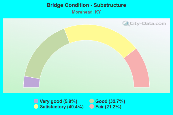
- Bridge Condition - Substructure
- 5.8%Very good
- 32.7%Good
- 40.4%Satisfactory
- 21.2%Fair
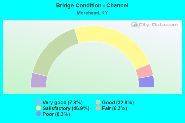
- Bridge Condition - Channel
- 7.8%Very good
- 32.8%Good
- 46.9%Satisfactory
- 6.3%Fair
- 6.3%Poor
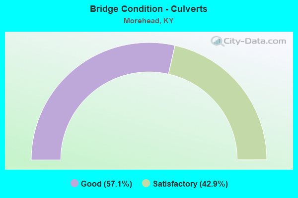
- Bridge Condition - Culverts
- 57.1%Good
- 42.9%Satisfactory
Find on map >> Show street view
Structure Number: 103C00045N, Location: .05 MI S OF JCT KY 1167 (Lat: 38.160833, Lng: -83.406667), Route carried "on" structure: Alternate County highway 1159, Year Built: 1960, Status: Posted for load, Structure Length: 1.46m (4.79ft), Average Daily Traffic: 278 (year 2009), Average Future Daily Traffic: 241 (year 2029), Features Intersected: DRY CREEK, Facility Carried by Structure: RAVENSWOOD RD
Minimum Vertical Clearance: 30+ m (98+ ft), Kilometerpoint: 0.037, Lanes on structure: 2, Owner: County Highway Agency, Approaching Roadway Width: 7.3m (24.0ft), Material/Design: Steel, Design/Construction: Stringer/Multi-beam, Number Of Spans In Main Unit: 1, Length of Maximum Span: 13.7m (44.9ft), Curb or Sidewalk Widths: Left: 0.2m (0.7ft), Right: 0.2m (0.7ft), Curb-To-Curb Width: 7.5m (24.6ft), Out-to-Out Width: 8.0m (26.2ft)
Condition: Deck: Good, Superstructure: Satisfactory, Substructure: Satisfactory, Channel: Satisfactory, Operating Rating: 16.3 metric tons, Method Used To Determine Operating Rating: Field evaluation and documented engineering judgment, Inventory Rating: 16.3 metric tons, Method Used To Determine Inventory Rating: Field evaluation and documented engineering judgment, Structural Evaluation: Somewhat better than minimum adequacy, Deck Geometry: Somewhat better than minimum adequacy, Waterway Adequacy: Better than present minimum criteria, Approach Roadway Alignment: Equal to present minimum criteria, Bridge Posting: Required (Relationship of Operating Rating to Maximum Legal Load: > 39.9% below), Length Of Structure Improvement: 0.15m (0.49ft), Designated Inspection Frequency: Every 24 months, Inspection Date: May 2020, Bridge Improvement Cost: $73,000, Total Project Cost: $72,000, Deck Structure Type: Concrete Cast-file-Place, Wearing Surface/Protective System: Wearing Surface: Monolithic Concrete
Find on map >> Show street view
Structure Number: 103C00051N, Location: 50 FT. WEST OF KY 32 (Lat: 38.238333, Lng: -83.508611), Route carried "on" structure: County highway 1222, Year Built: 1982, Status: Posted for load, Structure Length: 0.73m (2.40ft), Average Daily Traffic: 336 (year 2009), Average Future Daily Traffic: 292 (year 2029), Features Intersected: LITTLE BRUSHY CREEK, Facility Carried by Structure: BULLFORK RD
Minimum Vertical Clearance: 30+ m (98+ ft), Kilometerpoint: 0.084, Lanes on structure: 2, Owner: County Highway Agency, Approaching Roadway Width: 5.5m (18.0ft), Skew: 1 degrees, Material/Design: Steel, Design/Construction: Stringer/Multi-beam, Number Of Spans In Main Unit: 1, Length of Maximum Span: 6.7m (22.0ft), Curb or Sidewalk Widths: Left: 0.2m (0.7ft), Right: 0.2m (0.7ft), Curb-To-Curb Width: 7.6m (24.9ft), Out-to-Out Width: 7.9m (25.9ft)
Condition: Deck: Fair, Superstructure: Fair, Substructure: Good, Channel: Good, Operating Rating: 47.6 metric tons, Method Used To Determine Operating Rating: Load Factor (LF), Inventory Rating: 28.6 metric tons, Method Used To Determine Inventory Rating: Load Factor (LF), Structural Evaluation: Somewhat better than minimum adequacy, Deck Geometry: Somewhat better than minimum adequacy, Waterway Adequacy: Equal to present desirable criteria, Approach Roadway Alignment: Equal to present minimum criteria, Bridge Posting: Required (Relationship of Operating Rating to Maximum Legal Load: > 39.9% below), Designated Inspection Frequency: Every 24 months, Inspection Date: April 2020, Deck Structure Type: Concrete Cast-file-Place, Wearing Surface/Protective System: Wearing Surface: Bituminous
Find on map >> Show street view
Structure Number: 103C00053N, Location: 0.1 MI. EAST OF JCT KY785 (Lat: 38.235833, Lng: -83.487500), Route carried "on" structure: County highway 1332, Year Built: 1983, Status: Posted for load, Structure Length: 0.73m (2.40ft), Average Daily Traffic: 217 (year 2009), Average Future Daily Traffic: 188 (year 2029), Features Intersected: BIG BRUSHY CREEK, Facility Carried by Structure: PENNINGTON FLAT RD
Minimum Vertical Clearance: 30+ m (98+ ft), Kilometerpoint: 2.736, Lanes on structure: 2, Owner: County Highway Agency, Approaching Roadway Width: 5.2m (17.1ft), Material/Design: Steel, Design/Construction: Stringer/Multi-beam, Number Of Spans In Main Unit: 1, Length of Maximum Span: 7.0m (23.0ft), Curb or Sidewalk Widths: Left: 0.2m (0.7ft), Right: 0.2m (0.7ft), Curb-To-Curb Width: 7.3m (24.0ft), Out-to-Out Width: 7.6m (24.9ft)
Condition: Deck: Good, Superstructure: Satisfactory, Substructure: Satisfactory, Channel: Satisfactory, Operating Rating: 46.7 metric tons, Method Used To Determine Operating Rating: Load Factor (LF), Inventory Rating: 28.0 metric tons, Method Used To Determine Inventory Rating: Load Factor (LF), Structural Evaluation: Equal to present minimum criteria, Deck Geometry: Somewhat better than minimum adequacy, Waterway Adequacy: Equal to present desirable criteria, Approach Roadway Alignment: Equal to present minimum criteria, Bridge Posting: Required (Relationship of Operating Rating to Maximum Legal Load: > 39.9% below), Designated Inspection Frequency: Every 24 months, Inspection Date: April 2020, Deck Structure Type: Concrete Cast-file-Place, Wearing Surface/Protective System: Wearing Surface: Bituminous
Find on map >> Show street view
Structure Number: 103C00055N, Location: S-@ JCT KY 1167 (Lat: 38.165278, Lng: -83.425278), Route carried "on" structure: Spur County highway 1201, Year Built: 1983, Status: Posted for load, Structure Length: 1.74m (5.71ft), Average Daily Traffic: 205 (year 2009), Average Future Daily Traffic: 178 (year 2029), Features Intersected: DRY CREEK, Facility Carried by Structure: CARDINAL LANE E
Minimum Vertical Clearance: 30+ m (98+ ft), Kilometerpoint: 0.019, Lanes on structure: 2, Owner: County Highway Agency, Approaching Roadway Width: 5.5m (18.0ft), Material/Design: Steel, Design/Construction: Stringer/Multi-beam, Number Of Spans In Main Unit: 3, Length of Maximum Span: 6.1m (20.0ft), Curb or Sidewalk Widths: Left: 0.2m (0.7ft), Right: 0.2m (0.7ft), Curb-To-Curb Width: 6.2m (20.3ft), Out-to-Out Width: 6.5m (21.3ft)
Condition: Deck: Satisfactory, Superstructure: Fair, Substructure: Satisfactory, Channel: Satisfactory, Operating Rating: 32.7 metric tons, Method Used To Determine Operating Rating: Load Factor (LF), Inventory Rating: 19.6 metric tons, Method Used To Determine Inventory Rating: Load Factor (LF), Structural Evaluation: Somewhat better than minimum adequacy, Deck Geometry: Meets minimum limits, Waterway Adequacy: Equal to present desirable criteria, Approach Roadway Alignment: Meets minimum limits, Bridge Posting: Required (Relationship of Operating Rating to Maximum Legal Load: > 39.9% below), Length Of Structure Improvement: 0.17m (0.56ft), Designated Inspection Frequency: Every 12 months, Inspection Date: May 2021, Bridge Improvement Cost: $86,000, Total Project Cost: $85,000, Deck Structure Type: Concrete Cast-file-Place, Wearing Surface/Protective System: Wearing Surface: Monolithic Concrete
Find on map >> Show street view
Structure Number: 103C00061N, Location: .1 MI N. OF JCT KY 377 (Lat: 38.241389, Lng: -83.448333), Route carried "on" structure: County highway 1313, Year Built: 1986, Status: Posted for load, Structure Length: 0.73m (2.40ft), Average Daily Traffic: 338 (year 2009), Average Future Daily Traffic: 294 (year 2029), Features Intersected: POND LICK BRANCH, Facility Carried by Structure: POND LICK RD
Minimum Vertical Clearance: 30+ m (98+ ft), Kilometerpoint: 0.092, Lanes on structure: 2, Owner: County Highway Agency, Approaching Roadway Width: 6.4m (21.0ft), Skew: 1 degrees, Material/Design: Steel, Design/Construction: Stringer/Multi-beam, Number Of Spans In Main Unit: 1, Length of Maximum Span: 6.7m (22.0ft), Curb or Sidewalk Widths: Left: 0.2m (0.7ft), Right: 0.2m (0.7ft), Curb-To-Curb Width: 7.7m (25.3ft), Out-to-Out Width: 8.0m (26.2ft)
Condition: Deck: Satisfactory, Superstructure: Satisfactory, Substructure: Good, Channel: Satisfactory, Operating Rating: 23.1 metric tons, Method Used To Determine Operating Rating: Load Factor (LF), Inventory Rating: 13.9 metric tons, Method Used To Determine Inventory Rating: Load Factor (LF), Structural Evaluation: Meets minimum limits, Deck Geometry: Somewhat better than minimum adequacy, Waterway Adequacy: Equal to present desirable criteria, Approach Roadway Alignment: Meets minimum limits, Bridge Posting: Required (Relationship of Operating Rating to Maximum Legal Load: > 39.9% below), Length Of Structure Improvement: 0.07m (0.23ft), Designated Inspection Frequency: Every 12 months, Inspection Date: April 2021, Bridge Improvement Cost: $37,000, Total Project Cost: $36,000, Deck Structure Type: Concrete Cast-file-Place, Wearing Surface/Protective System: Wearing Surface: Bituminous
Find on map >> Show street view
Structure Number: 103C00062N, Location: 0.15 MILE N OF JCT KY 377 (Lat: 38.242222, Lng: -83.449167), Route carried "on" structure: County highway 1313, Year Built: 1987, Status: Posted for load, Structure Length: 0.70m (2.30ft), Average Daily Traffic: 338 (year 2009), Average Future Daily Traffic: 294 (year 2029), Features Intersected: LICK BRANCH, Facility Carried by Structure: POND LICK RD
Minimum Vertical Clearance: 30+ m (98+ ft), Kilometerpoint: 0.230, Lanes on structure: 2, Owner: County Highway Agency, Approaching Roadway Width: 6.4m (21.0ft), Material/Design: Steel, Design/Construction: Stringer/Multi-beam, Number Of Spans In Main Unit: 2, Length of Maximum Span: 3.4m (11.2ft), Curb or Sidewalk Widths: Left: 0.2m (0.7ft), Right: 0.2m (0.7ft), Curb-To-Curb Width: 7.7m (25.3ft), Out-to-Out Width: 8.0m (26.2ft)
Condition: Deck: Satisfactory, Superstructure: Satisfactory, Substructure: Satisfactory, Channel: Satisfactory, Operating Rating: 53.2 metric tons, Method Used To Determine Operating Rating: Load Factor (LF), Inventory Rating: 31.9 metric tons, Method Used To Determine Inventory Rating: Load Factor (LF), Structural Evaluation: Equal to present minimum criteria, Deck Geometry: Somewhat better than minimum adequacy, Waterway Adequacy: Equal to present desirable criteria, Approach Roadway Alignment: Meets minimum limits, Bridge Posting: Required (Relationship of Operating Rating to Maximum Legal Load: 20.0 - 29.9% below), Designated Inspection Frequency: Every 24 months, Inspection Date: April 2020, Deck Structure Type: Concrete Cast-file-Place, Wearing Surface/Protective System: Wearing Surface: Bituminous
Find on map >> Show street view
Structure Number: 103C00064N, Location: 0.0 MI S OF KY 32 (Lat: 38.185833, Lng: -83.354444), Route carried "on" structure: County highway 1024, Year Built: 1987, Status: Posted for load, Structure Length: 1.83m (6.00ft), Average Daily Traffic: 49 (year 2006), Average Future Daily Traffic: 79 (year 2026), Features Intersected: CHRISTY CREEK, Facility Carried by Structure: LEE BR
Minimum Vertical Clearance: 30+ m (98+ ft), Kilometerpoint: 0.031, Lanes on structure: 1, Owner: County Highway Agency, Approaching Roadway Width: 4.0m (13.1ft), Skew: 1 degrees, Material/Design: Steel, Design/Construction: Stringer/Multi-beam, Number Of Spans In Main Unit: 2, Length of Maximum Span: 8.8m (28.9ft), Curb or Sidewalk Widths: Left: 0.2m (0.7ft), Right: 0.2m (0.7ft), Curb-To-Curb Width: 4.0m (13.1ft), Out-to-Out Width: 4.3m (14.1ft)
Condition: Deck: Fair, Superstructure: Fair, Substructure: Fair, Channel: Fair, Operating Rating: 25.7 metric tons, Method Used To Determine Operating Rating: Load Factor (LF), Inventory Rating: 15.4 metric tons, Method Used To Determine Inventory Rating: Load Factor (LF), Structural Evaluation: Meets minimum limits, Deck Geometry: Somewhat better than minimum adequacy, Waterway Adequacy: Equal to present desirable criteria, Approach Roadway Alignment: Meets minimum limits, Bridge Posting: Required (Relationship of Operating Rating to Maximum Legal Load: > 39.9% below), Designated Inspection Frequency: Every 12 months, Inspection Date: April 2021, Deck Structure Type: Concrete Cast-file-Place, Wearing Surface/Protective System: Wearing Surface: Monolithic Concrete
Find on map >> Show street view
Structure Number: 103C00072N, Location: .1 MI SW - KY 32 (Lat: 38.235278, Lng: -83.505833), Route carried "on" structure: County highway 1365, Year Built: 1992, Status: Posted for load, Structure Length: 0.85m (2.79ft), Average Daily Traffic: 1,062 (year 2009), Average Future Daily Traffic: 923 (year 2029), Design Load: HS 25 or greater, Features Intersected: LITTLE BRUSHY CREEK, Facility Carried by Structure: JACKSON DR
Minimum Vertical Clearance: 30+ m (98+ ft), Kilometerpoint: 0.166, Lanes on structure: 2, Owner: County Highway Agency, Approaching Roadway Width: 5.5m (18.0ft), Skew: 3 degrees, Material/Design: Prestressed concrete, Design/Construction: Box Beam or Girders - Multiple, Number Of Spans In Main Unit: 1, Length of Maximum Span: 7.9m (25.9ft), Curb-To-Curb Width: 6.9m (22.6ft), Out-to-Out Width: 7.3m (24.0ft)
Condition: Deck: Good, Superstructure: Good, Substructure: Good, Channel: Satisfactory, Operating Rating: 57.4 metric tons, Method Used To Determine Operating Rating: Load Factor (LF), Inventory Rating: 34.5 metric tons, Method Used To Determine Inventory Rating: Load Factor (LF), Structural Evaluation: Better than present minimum criteria, Deck Geometry: High priority of corrective action, Waterway Adequacy: Equal to present desirable criteria, Approach Roadway Alignment: Equal to present minimum criteria, Bridge Posting: Required (Relationship of Operating Rating to Maximum Legal Load: 0.1 - 9.9% below), Designated Inspection Frequency: Every 24 months, Inspection Date: April 2020, Deck Structure Type: Concrete Precast Panels, Wearing Surface/Protective System: Wearing Surface: Bituminous
Find on map >> Show street view
Structure Number: 103C00076N, Location: .001 MI- JCT KY 32 (Lat: 38.188333, Lng: -83.364444), Route carried "on" structure: County highway 1077, Year Built: 1995, Status: Posted for load, Structure Length: 2.35m (7.71ft), Average Daily Traffic: 27 (year 2006), Average Future Daily Traffic: 43 (year 2026), Features Intersected: CHRISTY CREEK, Facility Carried by Structure: MESSER RD
Minimum Vertical Clearance: 30+ m (98+ ft), Kilometerpoint: 0.029, Lanes on structure: 1, Owner: County Highway Agency, Approaching Roadway Width: 4.0m (13.1ft), Material/Design: Steel, Design/Construction: Stringer/Multi-beam, Number Of Spans In Main Unit: 3, Length of Maximum Span: 8.2m (26.9ft), Curb or Sidewalk Widths: Left: 0.2m (0.7ft), Right: 0.2m (0.7ft), Curb-To-Curb Width: 3.9m (12.8ft), Out-to-Out Width: 4.3m (14.1ft)
Condition: Deck: Satisfactory, Superstructure: Fair, Substructure: Fair, Channel: Poor, Operating Rating: 28.6 metric tons, Method Used To Determine Operating Rating: Load Factor (LF), Inventory Rating: 17.1 metric tons, Method Used To Determine Inventory Rating: Load Factor (LF), Structural Evaluation: Somewhat better than minimum adequacy, Deck Geometry: Meets minimum limits, Waterway Adequacy: Equal to present desirable criteria, Approach Roadway Alignment: Equal to present minimum criteria, Bridge Posting: Required (Relationship of Operating Rating to Maximum Legal Load: > 39.9% below), Designated Inspection Frequency: Every 12 months, Inspection Date: May 2021, Deck Structure Type: Concrete Cast-file-Place, Wearing Surface/Protective System: Wearing Surface: Monolithic Concrete
Find on map >> Show street view
Structure Number: 103C00077N, Location: .1 MI W JCT KY 785 (Lat: 38.249167, Lng: -83.491667), Route carried "on" structure: County highway 1331, Year Built: 1994, Status: Open, Structure Length: 0.79m (2.59ft), Average Daily Traffic: 370 (year 2013), Average Future Daily Traffic: 370 (year 2033), Design Load: HS 25 or greater, Features Intersected: MID. PRONG-BRUSHY CK, Facility Carried by Structure: BIG WOODS RD
Minimum Vertical Clearance: 30+ m (98+ ft), Kilometerpoint: 3.298, Lanes on structure: 2, Owner: County Highway Agency, Approaching Roadway Width: 6.7m (22.0ft), Skew: 1 degrees, Material/Design: Prestressed concrete, Design/Construction: Box Beam or Girders - Multiple, Number Of Spans In Main Unit: 1, Length of Maximum Span: 7.0m (23.0ft), Curb or Sidewalk Widths: Left: 0.2m (0.7ft), Right: 0.2m (0.7ft), Curb-To-Curb Width: 6.8m (22.3ft), Out-to-Out Width: 7.3m (24.0ft)
Condition: Deck: Good, Superstructure: Good, Substructure: Good, Channel: Good, Operating Rating: 68.0 metric tons, Method Used To Determine Operating Rating: Load Factor (LF), Inventory Rating: 40.8 metric tons, Method Used To Determine Inventory Rating: Load Factor (LF), Structural Evaluation: Better than present minimum criteria, Deck Geometry: Meets minimum limits, Waterway Adequacy: Equal to present desirable criteria, Approach Roadway Alignment: Equal to present minimum criteria, Designated Inspection Frequency: Every 24 months, Inspection Date: April 2020, Deck Structure Type: Concrete Precast Panels, Wearing Surface/Protective System: Wearing Surface: Bituminous
Find on map >> Show street view
Structure Number: 103C00078N, Location: 91' WEST JCT KY 785 (Lat: 38.239722, Lng: -83.488889), Route carried "on" structure: County highway 1360, Year Built: 1994, Status: Open, Structure Length: 1.28m (4.20ft), Average Daily Traffic: 122 (year 2009), Average Future Daily Traffic: 106 (year 2029), Design Load: HS 25 or greater, Features Intersected: BIG BRUSHY CREEK, Facility Carried by Structure: EGAN LN
Minimum Vertical Clearance: 30+ m (98+ ft), Kilometerpoint: 0.037, Lanes on structure: 1, Owner: County Highway Agency, Approaching Roadway Width: 3.4m (11.2ft), Skew: 1 degrees, Material/Design: Prestressed concrete, Design/Construction: Box Beam or Girders - Multiple, Number Of Spans In Main Unit: 1, Length of Maximum Span: 11.9m (39.0ft), Curb-To-Curb Width: 4.4m (14.4ft), Out-to-Out Width: 5.0m (16.4ft)
Condition: Deck: Good, Superstructure: Good, Substructure: Good, Channel: Good, Operating Rating: 56.1 metric tons, Method Used To Determine Operating Rating: Load Factor (LF), Inventory Rating: 33.7 metric tons, Method Used To Determine Inventory Rating: Load Factor (LF), Structural Evaluation: Better than present minimum criteria, Deck Geometry: High priority of replacement, Waterway Adequacy: Equal to present desirable criteria, Approach Roadway Alignment: Better than present minimum criteria, Designated Inspection Frequency: Every 24 months, Inspection Date: April 2020, Deck Structure Type: Concrete Precast Panels, Wearing Surface/Protective System: Wearing Surface: Monolithic Concrete
Find on map >> Show street view
Structure Number: 103C00082N, Location: 2.5 MI W JCT US 60 (Lat: 38.173611, Lng: -83.516389), Route carried "on" structure: County highway 1397, Year Built: 1980, Year Reconstructed: 1997, Status: Posted for load, Structure Length: 1.44m (4.72ft), Average Daily Traffic: 10 (year 2009), Average Future Daily Traffic: 8 (year 2029), Features Intersected: Bull Fork Creek, Facility Carried by Structure: DEWITT CEMETERY RD
Minimum Vertical Clearance: 30+ m (98+ ft), Kilometerpoint: 0.117, Lanes on structure: 1, Owner: County Highway Agency, Approaching Roadway Width: 3.0m (9.8ft), Material/Design: Steel, Design/Construction: Stringer/Multi-beam, Number Of Spans In Main Unit: 2, Length of Maximum Span: 6.6m (21.7ft), Curb or Sidewalk Widths: Left: 0.2m (0.7ft), Right: 0.2m (0.7ft), Curb-To-Curb Width: 3.4m (11.2ft), Out-to-Out Width: 3.7m (12.1ft)
Condition: Deck: Satisfactory, Superstructure: Satisfactory, Substructure: Satisfactory, Channel: Poor, Operating Rating: 43.2 metric tons, Method Used To Determine Operating Rating: Load Factor (LF), Inventory Rating: 25.9 metric tons, Method Used To Determine Inventory Rating: Load Factor (LF), Structural Evaluation: Equal to present minimum criteria, Deck Geometry: High priority of corrective action, Waterway Adequacy: Equal to present minimum criteria, Approach Roadway Alignment: Meets minimum limits, Bridge Posting: Required (Relationship of Operating Rating to Maximum Legal Load: > 39.9% below), Designated Inspection Frequency: Every 24 months, Inspection Date: April 2020, Deck Structure Type: Concrete Cast-file-Place, Wearing Surface/Protective System: Wearing Surface: Monolithic Concrete
Find on map >> Show street view
Structure Number: 103C00083N, Location: .1 MI NE OF W-JCT KY 32 (Lat: 38.179167, Lng: -83.437222), Route carried "on" structure: City street 1032, Year Built: 1949, Status: Posted for load, Structure Length: 0.70m (2.30ft), Average Daily Traffic: 7,676 (year 2019), Average Future Daily Traffic: 7,138 (year 2039), Design Load: H 20, Features Intersected: OXLEY BRANCH, Facility Carried by Structure: WEST MAIN ST
Minimum Vertical Clearance: 30+ m (98+ ft), Kilometerpoint: 1.220, Lanes on structure: 2, Owner: City or Municipal Highway Agency, Approaching Roadway Width: 12.8m (42.0ft), Skew: 2 degrees, Material/Design: Concrete, Design/Construction: Culvert, Number Of Spans In Main Unit: 2, Length of Maximum Span: 3.0m (9.8ft)
Condition: Channel: Satisfactory, Culverts: Satisfactory, Operating Rating: 16.4 metric tons, Method Used To Determine Operating Rating: Field evaluation and documented engineering judgment, Inventory Rating: 16.3 metric tons, Method Used To Determine Inventory Rating: Field evaluation and documented engineering judgment, Structural Evaluation: Meets minimum limits, Waterway Adequacy: Equal to present desirable criteria, Approach Roadway Alignment: Equal to present desirable criteria, Bridge Posting: Required (Relationship of Operating Rating to Maximum Legal Load: > 39.9% below), Designated Inspection Frequency: Every 24 months, Inspection Date: May 2020
Find on map >> Show street view
Structure Number: 103C00084N, Location: .2 MI SW OF W-JCT KY 32 (Lat: 38.173889, Lng: -83.440000), Route carried "on" structure: City street 1032, Year Built: 1949, Status: Open, Structure Length: 0.82m (2.69ft), Average Daily Traffic: 4,540 (year 2009), Average Future Daily Traffic: 4,267 (year 2029), Design Load: H 15, Features Intersected: TOWN BRANCH, Facility Carried by Structure: WEST MAIN ST
Minimum Vertical Clearance: 30+ m (98+ ft), Kilometerpoint: 0.583, Lanes on structure: 1, Owner: City or Municipal Highway Agency, Approaching Roadway Width: 12.5m (41.0ft), Material/Design: Concrete, Design/Construction: Culvert, Number Of Spans In Main Unit: 2, Length of Maximum Span: 3.7m (12.1ft), Curb or Sidewalk Widths: Left: 1.2m (3.9ft), Right: 1.2m (3.9ft)
Condition: Channel: Good, Culverts: Satisfactory, Operating Rating: 60.8 metric tons, Method Used To Determine Operating Rating: Load Factor (LF), Inventory Rating: 36.6 metric tons, Method Used To Determine Inventory Rating: Load Factor (LF), Structural Evaluation: Equal to present minimum criteria, Waterway Adequacy: Equal to present desirable criteria, Approach Roadway Alignment: Equal to present desirable criteria, Designated Inspection Frequency: Every 24 months, Inspection Date: May 2020
Find on map >> Show street view
Structure Number: 103C00087N, Location: 1.5 MI.W.-JCT KY 32 (Lat: 38.193611, Lng: -83.493333), Route carried "on" structure: County highway 1391, Year Built: 1979, Year Reconstructed: 1992, Status: Posted for load, Structure Length: 0.91m (2.99ft), Average Daily Traffic: 779 (year 2009), Average Future Daily Traffic: 677 (year 2029), Features Intersected: LOGAN HOLLOW BRANCH, Facility Carried by Structure: BRATTON BR
Minimum Vertical Clearance: 30+ m (98+ ft), Kilometerpoint: 1.308, Lanes on structure: 2, Owner: County Highway Agency, Approaching Roadway Width: 4.0m (13.1ft), Material/Design: Steel, Design/Construction: Stringer/Multi-beam, Number Of Spans In Main Unit: 1, Length of Maximum Span: 8.4m (27.6ft), Curb or Sidewalk Widths: Left: 0.2m (0.7ft), Right: 0.2m (0.7ft), Curb-To-Curb Width: 7.6m (24.9ft), Out-to-Out Width: 7.9m (25.9ft)
Condition: Deck: Satisfactory, Superstructure: Satisfactory, Substructure: Good, Channel: Good, Operating Rating: 23.0 metric tons, Method Used To Determine Operating Rating: Load Factor (LF), Inventory Rating: 13.8 metric tons, Method Used To Determine Inventory Rating: Load Factor (LF), Structural Evaluation: Meets minimum limits, Deck Geometry: Meets minimum limits, Waterway Adequacy: Equal to present desirable criteria, Approach Roadway Alignment: Equal to present minimum criteria, Bridge Posting: Required (Relationship of Operating Rating to Maximum Legal Load: > 39.9% below), Designated Inspection Frequency: Every 12 months, Inspection Date: May 2021, Deck Structure Type: Concrete Cast-file-Place, Wearing Surface/Protective System: Wearing Surface: Monolithic Concrete
Find on map >> Show street view
Structure Number: 103C00089N, Location: 180 FT S JCT KY 32 (Lat: 38.190556, Lng: -83.378333), Route carried "on" structure: County highway 1074, Year Built: 1990, Status: Posted for load, Structure Length: 2.44m (8.01ft), Average Daily Traffic: 32 (year 2006), Average Future Daily Traffic: 52 (year 2026), Features Intersected: CHRISTY CREEK, Facility Carried by Structure: TACKETT BR
Minimum Vertical Clearance: 30+ m (98+ ft), Kilometerpoint: 0.060, Lanes on structure: 1, Owner: County Highway Agency, Approaching Roadway Width: 3.4m (11.2ft), Material/Design: Steel, Design/Construction: Stringer/Multi-beam, Number Of Spans In Main Unit: 3, Length of Maximum Span: 8.5m (27.9ft), Curb or Sidewalk Widths: Left: 0.2m (0.7ft), Right: 0.2m (0.7ft), Curb-To-Curb Width: 3.3m (10.8ft), Out-to-Out Width: 3.7m (12.1ft)
Condition: Deck: Good, Superstructure: Poor, Substructure: Fair, Channel: Satisfactory, Operating Rating: 33.3 metric tons, Method Used To Determine Operating Rating: Field evaluation and documented engineering judgment, Inventory Rating: 20.0 metric tons, Method Used To Determine Inventory Rating: Field evaluation and documented engineering judgment, Structural Evaluation: Meets minimum limits, Deck Geometry: High priority of replacement, Waterway Adequacy: Better than present minimum criteria, Approach Roadway Alignment: Better than present minimum criteria, Bridge Posting: Required (Relationship of Operating Rating to Maximum Legal Load: > 39.9% below), Designated Inspection Frequency: Every 24 months, Inspection Date: May 2020, Deck Structure Type: Concrete Cast-file-Place, Wearing Surface/Protective System: Wearing Surface: Monolithic Concrete
Find on map >> Show street view
Structure Number: 103C00090N, Location: .163 MI FROM KY 32 (Lat: 38.225556, Lng: -83.491944), Route carried "on" structure: County highway 1363, Year Built: 2002, Status: Posted for load, Structure Length: 1.22m (4.00ft), Average Daily Traffic: 114 (year 2009), Average Future Daily Traffic: 99 (year 2029), Features Intersected: OVER LITTLE BRUSHY CREEK, Facility Carried by Structure: OLD HILDA RD
Minimum Vertical Clearance: 30+ m (98+ ft), Kilometerpoint: 0.280, Lanes on structure: 2, Owner: County Highway Agency, Approaching Roadway Width: 5.5m (18.0ft), Material/Design: Steel, Design/Construction: Stringer/Multi-beam, Number Of Spans In Main Unit: 2, Length of Maximum Span: 5.8m (19.0ft), Curb or Sidewalk Widths: Left: 0.2m (0.7ft), Right: 0.2m (0.7ft), Curb-To-Curb Width: 5.6m (18.4ft), Out-to-Out Width: 5.9m (19.4ft)
Condition: Deck: Good, Superstructure: Poor, Substructure: Satisfactory, Channel: Satisfactory, Operating Rating: 39.2 metric tons, Method Used To Determine Operating Rating: Load Factor (LF), Inventory Rating: 23.5 metric tons, Method Used To Determine Inventory Rating: Load Factor (LF), Structural Evaluation: Meets minimum limits, Deck Geometry: High priority of corrective action, Waterway Adequacy: Equal to present minimum criteria, Approach Roadway Alignment: Better than present minimum criteria, Bridge Posting: Required (Relationship of Operating Rating to Maximum Legal Load: > 39.9% below), Designated Inspection Frequency: Every 24 months, Inspection Date: April 2020, Deck Structure Type: Concrete Cast-file-Place, Wearing Surface/Protective System: Wearing Surface: Bituminous
Find on map >> Show street view
Structure Number: 103C00094N, Location: 68' WEST OF KY 799 (Lat: 38.236667, Lng: -83.376667), Route carried "on" structure: County highway 1505, Year Built: 1993, Status: Posted for load, Structure Length: 1.68m (5.51ft), Average Daily Traffic: 94 (year 2009), Average Future Daily Traffic: 81 (year 2029), Features Intersected: BIG PERRY CREEK, Facility Carried by Structure: GENE WHITE LN
Minimum Vertical Clearance: 30+ m (98+ ft), Kilometerpoint: 0.032, Lanes on structure: 1, Owner: County Highway Agency, Approaching Roadway Width: 4.3m (14.1ft), Material/Design: Steel, Design/Construction: Stringer/Multi-beam, Number Of Spans In Main Unit: 1, Length of Maximum Span: 15.2m (49.9ft), Curb-To-Curb Width: 4.2m (13.8ft), Out-to-Out Width: 4.6m (15.1ft)
Condition: Deck: Satisfactory, Superstructure: Fair, Substructure: Satisfactory, Channel: Satisfactory, Operating Rating: 8.2 metric tons, Method Used To Determine Operating Rating: Field evaluation and documented engineering judgment, Inventory Rating: 8.2 metric tons, Method Used To Determine Inventory Rating: Field evaluation and documented engineering judgment, Structural Evaluation: High priority of corrective action, Deck Geometry: Somewhat better than minimum adequacy, Waterway Adequacy: Equal to present desirable criteria, Approach Roadway Alignment: Equal to present desirable criteria, Bridge Posting: Required (Relationship of Operating Rating to Maximum Legal Load: > 39.9% below), Designated Inspection Frequency: Every 12 months, Inspection Date: May 2021, Deck Structure Type: Concrete Cast-file-Place, Wearing Surface/Protective System: Wearing Surface: Monolithic Concrete
Find on map >> Show street view
Structure Number: 103C00096N, Location: .15 MI S/E OF KY 60 (Lat: 38.191667, Lng: -83.415833), Route carried "on" structure: City street 1034, Year Built: 2003, Status: Posted for load, Structure Length: 2.71m (8.89ft), Average Daily Traffic: 40 (year 2009), Average Future Daily Traffic: 34 (year 2029), Features Intersected: TRIPLETT CREEK, Facility Carried by Structure: SOUTH TOLLIVER RD
Minimum Vertical Clearance: 30+ m (98+ ft), Kilometerpoint: 0.272, Lanes on structure: 1, Owner: City or Municipal Highway Agency, Approaching Roadway Width: 4.0m (13.1ft), Material/Design: Steel, Design/Construction: Truss - Thru, Number Of Spans In Main Unit: 1, Length of Maximum Span: 25.9m (85.0ft), Curb-To-Curb Width: 3.8m (12.5ft), Out-to-Out Width: 3.9m (12.8ft)
Condition: Deck: Satisfactory, Superstructure: Good, Substructure: Good, Channel: Satisfactory, Operating Rating: 11.3 metric tons, Method Used To Determine Operating Rating: Load and Resistance Factor Rating (LRFR) rating reported by rating factor(RF) method using HL-93 loadings, Inventory Rating: 6.5 metric tons, Method Used To Determine Inventory Rating: Load and Resistance Factor Rating (LRFR) rating reported by rating factor(RF) method using HL-93 loadings, Structural Evaluation: High priority of corrective action, Deck Geometry: Meets minimum limits, Waterway Adequacy: Equal to present desirable criteria, Approach Roadway Alignment: Equal to present minimum criteria, Bridge Posting: Required (Relationship of Operating Rating to Maximum Legal Load: > 39.9% below), Designated Inspection Frequency: Every 12 months, Critical Feature Inspection Frequency: Every 24 months, Inspection Date: May 2021, Critical Feature Inspection Date: May 2020, Deck Structure Type: Concrete Cast-file-Place, Wearing Surface/Protective System: Wearing Surface: Monolithic Concrete
Find on map >> Show street view
Structure Number: 103C00101N, Location: 2.35 MI. N OF US 60 (Lat: 38.174722, Lng: -83.515556), Route carried "on" structure: County highway 1222, Year Built: 2003, Status: Open, Structure Length: 0.73m (2.40ft), Average Daily Traffic: 139 (year 2009), Average Future Daily Traffic: 120 (year 2029), Features Intersected: BULL FORK CREEK, Facility Carried by Structure: BULLFORK RD
Minimum Vertical Clearance: 30+ m (98+ ft), Kilometerpoint: 9.653, Lanes on structure: 2, Owner: County Highway Agency, Approaching Roadway Width: 3.7m (12.1ft), Skew: 3 degrees, Material/Design: Steel, Design/Construction: Stringer/Multi-beam, Number Of Spans In Main Unit: 1, Length of Maximum Span: 6.7m (22.0ft), Curb or Sidewalk Widths: Left: 0.2m (0.7ft), Right: 0.2m (0.7ft), Curb-To-Curb Width: 7.6m (24.9ft), Out-to-Out Width: 7.9m (25.9ft)
Condition: Deck: Good, Superstructure: Good, Substructure: Good, Channel: Good, Operating Rating: 69.1 metric tons, Method Used To Determine Operating Rating: Load Factor (LF), Inventory Rating: 41.5 metric tons, Method Used To Determine Inventory Rating: Load Factor (LF), Structural Evaluation: Better than present minimum criteria, Deck Geometry: Somewhat better than minimum adequacy, Waterway Adequacy: Equal to present desirable criteria, Approach Roadway Alignment: Meets minimum limits, Designated Inspection Frequency: Every 24 months, Inspection Date: May 2020, Deck Structure Type: Concrete Cast-file-Place, Wearing Surface/Protective System: Wearing Surface: Monolithic Concrete
Find on map >> Show street view
Structure Number: 103C00103N, Location: 200' SE jct us 60 (Lat: 38.203611, Lng: -83.404722), Route carried "on" structure: County highway 1058, Year Built: 2007, Status: Open, Structure Length: 1.62m (5.31ft), Average Daily Traffic: 24 (year 2009), Average Future Daily Traffic: 20 (year 2029), Features Intersected: TRIPLETT CREEK, Facility Carried by Structure: JAYCEE FARM ROAD
Minimum Vertical Clearance: 30+ m (98+ ft), Kilometerpoint: 0.074, Lanes on structure: 2, Owner: County Highway Agency, Approaching Roadway Width: 5.8m (19.0ft), Material/Design: Steel, Design/Construction: Stringer/Multi-beam, Number Of Spans In Main Unit: 1, Length of Maximum Span: 14.5m (47.6ft), Curb or Sidewalk Widths: Left: 0.2m (0.7ft), Right: 0.2m (0.7ft), Curb-To-Curb Width: 7.2m (23.6ft), Out-to-Out Width: 7.6m (24.9ft)
Condition: Deck: Satisfactory, Superstructure: Satisfactory, Substructure: Satisfactory, Channel: Satisfactory, Operating Rating: 69.0 metric tons, Method Used To Determine Operating Rating: Load Factor (LF), Inventory Rating: 41.4 metric tons, Method Used To Determine Inventory Rating: Load Factor (LF), Structural Evaluation: Equal to present minimum criteria, Deck Geometry: Somewhat better than minimum adequacy, Waterway Adequacy: Equal to present minimum criteria, Approach Roadway Alignment: Equal to present minimum criteria, Designated Inspection Frequency: Every 24 months, Inspection Date: May 2020, Deck Structure Type: Concrete Cast-file-Place, Wearing Surface/Protective System: Wearing Surface: Monolithic Concrete
Find on map >> Show street view
Structure Number: 103C00104N, Location: JUCTION OF HARRITAGE PLAC (Lat: 38.179167, Lng: -83.445278), Route carried "on" structure: City street 1136, Year Built: 2006, Status: Posted for load, Structure Length: 0.99m (3.25ft), Features Intersected: TOWN BRANCH
Minimum Vertical Clearance: 30+ m (98+ ft), Kilometerpoint: 0.245, Lanes on structure: 2, Owner: City or Municipal Highway Agency, Approaching Roadway Width: 5.8m (19.0ft), Material/Design: Steel, Design/Construction: Stringer/Multi-beam, Number Of Spans In Main Unit: 1, Length of Maximum Span: 9.2m (30.2ft), Curb or Sidewalk Widths: Left: 0.0m, Right: 1.2m (3.9ft), Curb-To-Curb Width: 7.3m (24.0ft), Out-to-Out Width: 9.4m (30.8ft)
Condition: Deck: Good, Superstructure: Satisfactory, Substructure: Fair, Channel: Satisfactory, Operating Rating: 31.9 metric tons, Method Used To Determine Operating Rating: Load Factor (LF), Inventory Rating: 19.1 metric tons, Method Used To Determine Inventory Rating: Load Factor (LF), Structural Evaluation: Somewhat better than minimum adequacy, Deck Geometry: Equal to present minimum criteria, Waterway Adequacy: Somewhat better than minimum adequacy, Approach Roadway Alignment: Better than present minimum criteria, Bridge Posting: Required (Relationship of Operating Rating to Maximum Legal Load: > 39.9% below), Designated Inspection Frequency: Every 12 months, Inspection Date: May 2021, Deck Structure Type: Concrete Cast-file-Place, Wearing Surface/Protective System: Wearing Surface: Monolithic Concrete, Deck Protection: Epoxy Coated Reinforcing
Find on map >> Show street view
Structure Number: 103C00109N, Location: .02 MI SE OF JCT KY 519 (Lat: 38.157778, Lng: -83.425000), Route carried "on" structure: County highway 1209, Year Built: 1970, Status: Open, Structure Length: 0.91m (2.99ft), Average Daily Traffic: 3,860 (year 2008), Truck Traffic: 13%, Average Future Daily Traffic: 5,751 (year 2028), Design Load: HS 20, Features Intersected: MORGAN FORK
Minimum Vertical Clearance: 30+ m (98+ ft), Kilometerpoint: 1.281, Lanes on structure: 1, Owner: County Highway Agency, Approaching Roadway Width: 13.7m (44.9ft), Skew: 4 degrees, Material/Design: Concrete, Design/Construction: Culvert, Number Of Spans In Main Unit: 2, Length of Maximum Span: 4.3m (14.1ft)
Condition: Channel: Satisfactory, Culverts: Good, Operating Rating: 54.4 metric tons, Method Used To Determine Operating Rating: Field evaluation and documented engineering judgment, Inventory Rating: 40.8 metric tons, Method Used To Determine Inventory Rating: Field evaluation and documented engineering judgment, Structural Evaluation: Better than present minimum criteria, Waterway Adequacy: Equal to present minimum criteria, Approach Roadway Alignment: Somewhat better than minimum adequacy, Designated Inspection Frequency: Every 24 months, Inspection Date: May 2020
Find on map >> Show street view
Structure Number: 103C00111N, Location: 186' N. of US 60 (Lat: 38.236667, Lng: -83.363333), Route carried "on" structure: County highway 1070, Year Built: 2015, Status: Open, Structure Length: 2.55m (8.37ft), Average Daily Traffic: 196 (year 2009), Average Future Daily Traffic: 170 (year 2029), Design Load: Greater than HL93, Features Intersected: Triplett Creek
Minimum Vertical Clearance: 30+ m (98+ ft), Kilometerpoint: 0.069, Lanes on structure: 2, Owner: County Highway Agency, Approaching Roadway Width: 4.9m (16.1ft), Material/Design: Prestressed concrete, Design/Construction: Box Beam or Girders - Single/Spread, Number Of Spans In Main Unit: 1, Length of Maximum Span: 23.7m (77.8ft), Curb-To-Curb Width: 5.1m (16.7ft), Out-to-Out Width: 5.5m (18.0ft)
Condition: Deck: Very good, Superstructure: Very good, Substructure: Very good, Channel: Fair, Operating Rating: 87.8 metric tons, Method Used To Determine Operating Rating: Load and Resistance Factor Rating (LRFR) rating reported by rating factor(RF) method using HL-93 loadings, Inventory Rating: 67.7 metric tons, Method Used To Determine Inventory Rating: Load and Resistance Factor Rating (LRFR) rating reported by rating factor(RF) method using HL-93 loadings, Structural Evaluation: Equal to present desirable criteria, Deck Geometry: High priority of replacement, Waterway Adequacy: Equal to present minimum criteria, Approach Roadway Alignment: Equal to present minimum criteria, Designated Inspection Frequency: Every 24 months, Inspection Date: April 2020, Deck Structure Type: Concrete Cast-file-Place, Wearing Surface/Protective System: Wearing Surface: Monolithic Concrete, Deck Protection: Epoxy Coated Reinforcing
Find on map >> Show street view
Structure Number: 103C00114N, Location: 100' west of bull fork (Lat: 38.178889, Lng: -83.522222), Route carried "on" structure: County highway 1713, Year Built: 2016, Status: Open, Structure Length: 1.37m (4.49ft), Average Daily Traffic: 40 (year 2018), Average Future Daily Traffic: 2,038 (year 2038), Features Intersected: BULL FORK, Facility Carried by Structure: HORSEMAN CEM 1140
Minimum Vertical Clearance: 30+ m (98+ ft), Kilometerpoint: 0.040, Lanes on structure: 1, Owner: County Highway Agency, Approaching Roadway Width: 3.0m (9.8ft), Skew: 1 degrees, Material/Design: Steel, Design/Construction: Stringer/Multi-beam, Number Of Spans In Main Unit: 1, Length of Maximum Span: 12.8m (42.0ft), Curb or Sidewalk Widths: Left: 0.2m (0.7ft), Right: 0.2m (0.7ft), Curb-To-Curb Width: 4.5m (14.8ft), Out-to-Out Width: 4.8m (15.7ft)
Condition: Deck: Very good, Superstructure: Very good, Substructure: Good, Channel: Good, Operating Rating: 99.8 metric tons, Method Used To Determine Operating Rating: Load Factor (LF), Inventory Rating: 67.8 metric tons, Method Used To Determine Inventory Rating: Load Factor (LF), Structural Evaluation: Better than present minimum criteria, Deck Geometry: Equal to present minimum criteria, Waterway Adequacy: Equal to present minimum criteria, Approach Roadway Alignment: Equal to present minimum criteria, Designated Inspection Frequency: Every 24 months, Inspection Date: May 2020, Deck Structure Type: Concrete Cast-file-Place, Wearing Surface/Protective System: Wearing Surface: Monolithic Concrete
Find on map >> Show street view
Structure Number: 103B00054L, Location: WBL 2.4 MI W OF KY32 NTRC (Lat: 38.186389, Lng: -83.523333), Route carried "under" structure: County highway 1222, Year Built: 1968, Structure Length: 0. m, Average Daily Traffic: 29 (year 2006), Features Intersected: BULL FORK CRK & ROAD, Facility Carried by Structure: I-64 NC
Minimum Vertical Clearance: 12.80m (41.99ft), Kilometerpoint: 8.044, Lanes on structure: 2, Lanes under structure: 2, Material/Design: Steel continuous, Design/Construction: Stringer/Multi-beam, Length of Maximum Span: 42.7m (140.1ft)
Find on map >> Show street view
Structure Number: 103B00054R, Location: EBL 2.4 MI W OF KY32 NTRC (Lat: 38.186111, Lng: -83.523333), Route carried "under" structure: County highway 1222, Year Built: 1968, Structure Length: 0. m, Average Daily Traffic: 29 (year 2006), Features Intersected: BULL FORK CRK & ROAD, Facility Carried by Structure: I-64
Minimum Vertical Clearance: 30+ m (98+ ft), Kilometerpoint: 8.069, Lanes on structure: 2, Lanes under structure: 2, Material/Design: Steel continuous, Design/Construction: Stringer/Multi-beam, Length of Maximum Span: 42.7m (140.1ft)
Find on map >> Show street view
Structure Number: 103B00055L, Location: WBL .8 MI W OF KY 32 NTRC (Lat: 38.187778, Lng: -83.494722), Route carried "under" structure: County highway 1224, Year Built: 1968, Structure Length: 0. m, Average Daily Traffic: 302 (year 2006), Features Intersected: CR 5224 + N.FK.TRIPLTT C, Facility Carried by Structure: I-64 NC
Minimum Vertical Clearance: 5.26m (17.26ft), Kilometerpoint: 1.627, Lanes on structure: 2, Lanes under structure: 2, Material/Design: Concrete continuous, Design/Construction: Tee Beam, Length of Maximum Span: 30.5m (100.1ft)
Find on map >> Show street view
Structure Number: 103B00055R, Location: EBL .8 MI W OF KY 32 NTRC (Lat: 38.187500, Lng: -83.494722), Route carried "under" structure: County highway 1224, Year Built: 1968, Structure Length: 0. m, Average Daily Traffic: 302 (year 2006), Features Intersected: CR 5224 + N.FK.TRIPLTT C, Facility Carried by Structure: I-64
Minimum Vertical Clearance: 30+ m (98+ ft), Kilometerpoint: 1.659, Lanes on structure: 2, Lanes under structure: 2, Material/Design: Concrete continuous, Design/Construction: Tee Beam, Length of Maximum Span: 30.5m (100.1ft)
Find on map >> Show street view
Structure Number: 103B00056L, Location: WBL @KY 32-MOREHEAD-NTRCH (Lat: 38.192222, Lng: -83.478611), Route carried "under" structure: State highway 32, Year Built: 1968, Structure Length: 0. m, Average Daily Traffic: 29,809 (year 2019), Truck Traffic: 5%, Features Intersected: KY 32, Facility Carried by Structure: I-64 NC
Minimum Vertical Clearance: 5.28m (17.32ft), Kilometerpoint: 8.996, Lanes on structure: 2, Lanes under structure: 4, Material/Design: Prestressed concrete, Design/Construction: Stringer/Multi-beam, Length of Maximum Span: 21.3m (69.9ft)
Find on map >> Show street view
Structure Number: 103B00056R, Location: EBL @KY 32-MOREHEAD-NTRCH (Lat: 38.192222, Lng: -83.478611), Route carried "under" structure: State highway 32, Year Built: 1968, Structure Length: 0. m, Average Daily Traffic: 29,809 (year 2019), Truck Traffic: 5%, Features Intersected: KY32, Facility Carried by Structure: I-64
Minimum Vertical Clearance: 5.61m (18.41ft), Kilometerpoint: 9.024, Lanes on structure: 2, Lanes under structure: 4, Material/Design: Prestressed concrete, Design/Construction: Stringer/Multi-beam, Length of Maximum Span: 21.3m (69.9ft)
Find on map >> Show street view
Structure Number: 103X00100N, Location: .374 mi. w of jct us60 (Lat: 38.179167, Lng: -83.441667), Route carried "under" structure: State highway 32, Year Built: 2003, Structure Length: 0. m, Average Daily Traffic: 21,492 (year 2020), Truck Traffic: 5%, Features Intersected: KY 32, Facility Carried by Structure: Pedestrian Bridge
Minimum Vertical Clearance: 5.64m (18.50ft), Kilometerpoint: 12.981, Lanes under structure: 4, Material/Design: Prestressed concrete, Design/Construction: Stringer/Multi-beam, Length of Maximum Span: 33.4m (109.6ft)