Bridge Statistics for Morgantown, West Virginia (WV)
Condition, Traffic, Stress, Structural Evaluation, Project Costs
- National Bridge Inventory (NBI) Statistics
- 82Number of bridges
- 994ft / 303mTotal length
- $32,887,000Total costs
- 1,022,366Total average daily traffic
- 126,359Total average daily truck traffic
- National Bridge Inventory (NBI) Registered Bridges for Morgantown
- No street view available for this location
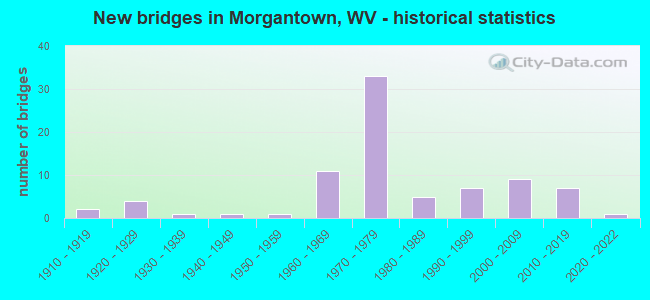
- New bridges - historical statistics
- 21910-1919
- 41920-1929
- 11930-1939
- 11940-1949
- 11950-1959
- 111960-1969
- 331970-1979
- 51980-1989
- 71990-1999
- 92000-2009
- 72010-2019
- 12020-2022
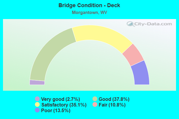
- Bridge Condition - Deck
- 2.7%Very good
- 37.8%Good
- 35.1%Satisfactory
- 10.8%Fair
- 13.5%Poor
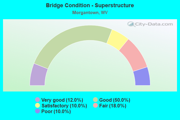
- Bridge Condition - Superstructure
- 12.0%Very good
- 50.0%Good
- 10.0%Satisfactory
- 18.0%Fair
- 10.0%Poor

- Bridge Condition - Substructure
- 6.3%Very good
- 37.5%Good
- 25.0%Satisfactory
- 25.0%Fair
- 6.3%Poor
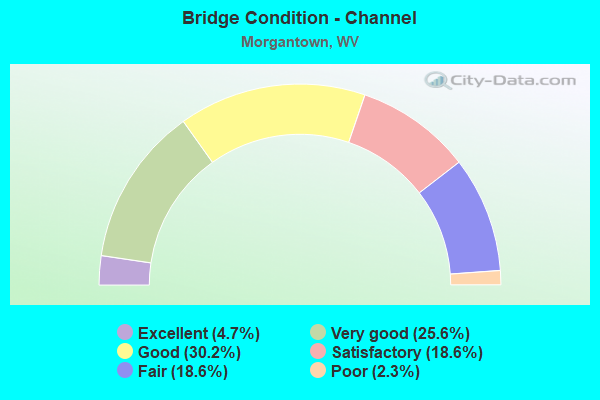
- Bridge Condition - Channel
- 4.7%Excellent
- 25.6%Very good
- 30.2%Good
- 18.6%Satisfactory
- 18.6%Fair
- 2.3%Poor
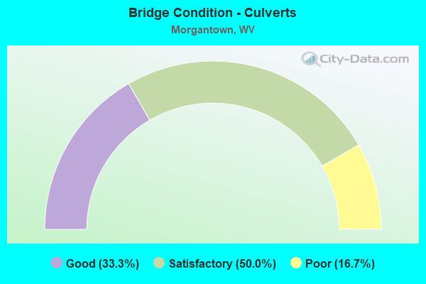
- Bridge Condition - Culverts
- 33.3%Good
- 50.0%Satisfactory
- 16.7%Poor
Find on map >> Show street view
Structure Number: 31A016, Location: 0.02 MI WEST WV RT 7 (Lat: 39.628519, Lng: -79.953981), Route carried "on" structure: State highway 700, Year Built: 1979, Status: Open, Structure Length: 15.23m (49.97ft), Average Daily Traffic: 12,000 (year 2018), Truck Traffic: 7%, Average Future Daily Traffic: 16,325 (year 2038), Design Load: HS 20, Features Intersected: DECKERS CREEK, Facility Carried by Structure: WV ROUTE 7 WB
Minimum Vertical Clearance: 30+ m (98+ ft), Kilometerpoint: 0.032, Lanes on structure: 2, Owner: State Highway Agency, Approaching Roadway Width: 9.1m (29.9ft), Material/Design: Steel continuous, Design/Construction: Stringer/Multi-beam, Number Of Spans In Main Unit: 2, Number Of Approach Spans: 2, Length of Maximum Span: 43.4m (142.4ft), Curb or Sidewalk Widths: Left: 1.5m (4.9ft), Right: 0.0m, Curb-To-Curb Width: 8.7m (28.5ft), Out-to-Out Width: 11.7m (38.4ft)
Condition: Deck: Poor, Superstructure: Satisfactory, Substructure: Satisfactory, Channel: Good, Operating Rating: 73.5 metric tons, Method Used To Determine Operating Rating: Load Factor (LF), Inventory Rating: 44.4 metric tons, Method Used To Determine Inventory Rating: Load Factor (LF), Structural Evaluation: Equal to present minimum criteria, Deck Geometry: Meets minimum limits, Waterway Adequacy: Superior to present desirable criteria, Approach Roadway Alignment: Equal to present minimum criteria, Length Of Structure Improvement: 15.24m (50.00ft), Designated Inspection Frequency: Every 24 months, Inspection Date: January 2020, Bridge Improvement Cost: $341,000, Roadway Improvement Cost: $105,000, Total Project Cost: $511,000 ( Estimate for 2020), Deck Structure Type: Concrete Cast-file-Place, Wearing Surface/Protective System: Deck Protection: Epoxy Coated Reinforcing
Find on map >> Show street view
Structure Number: 31A017, Location: 0.05 MI EAST US ROUTE 119 (Lat: 39.627511, Lng: -79.955300), Route carried "on" structure: State highway 700, Year Built: 1992, Status: Open, Structure Length: 16.85m (55.28ft), Average Daily Traffic: 15,000 (year 2020), Truck Traffic: 7%, Average Future Daily Traffic: 20,400 (year 2040), Design Load: HS 25 or greater, Features Intersected: DECKERS CREEK, Facility Carried by Structure: WV ROUTE 7
Minimum Vertical Clearance: 30+ m (98+ ft), Kilometerpoint: 53.382, Lanes on structure: 2, Owner: State Highway Agency, Approaching Roadway Width: 8.2m (26.9ft), Material/Design: Steel continuous, Design/Construction: Stringer/Multi-beam, Number Of Spans In Main Unit: 3, Number Of Approach Spans: 2, Length of Maximum Span: 44.8m (147.0ft), Curb or Sidewalk Widths: Left: 2.3m (7.5ft), Right: 2.3m (7.5ft), Curb-To-Curb Width: 8.2m (26.9ft), Out-to-Out Width: 13.4m (44.0ft)
Condition: Deck: Satisfactory, Superstructure: Very good, Substructure: Good, Channel: Very good, Operating Rating: 87.1 metric tons, Method Used To Determine Operating Rating: Load Factor (LF), Inventory Rating: 52.6 metric tons, Method Used To Determine Inventory Rating: Load Factor (LF), Structural Evaluation: Better than present minimum criteria, Deck Geometry: High priority of corrective action, Waterway Adequacy: Superior to present desirable criteria, Approach Roadway Alignment: Equal to present minimum criteria, Length Of Structure Improvement: 17.07m (56.00ft), Designated Inspection Frequency: Every 24 months, Inspection Date: December 2020, Bridge Improvement Cost: $2,189,000, Roadway Improvement Cost: $1,537,000, Total Project Cost: $3,754,000 ( Estimate for 2021), Deck Structure Type: Concrete Cast-file-Place, Wearing Surface/Protective System: Deck Protection: Epoxy Coated Reinforcing
Find on map >> Show street view
Structure Number: 31A018, Location: 0.65 MI WEST CO RT 64 (Lat: 39.624839, Lng: -79.944811), Route carried "on" structure: State highway 700, Year Built: 1991, Status: Open, Structure Length: 4.32m (14.17ft), Average Daily Traffic: 13,000 (year 2019), Truck Traffic: 6%, Average Future Daily Traffic: 16,800 (year 2041), Design Load: HS 25 or greater, Features Intersected: DECKERS CREEK, Facility Carried by Structure: WV ROUTE 7
Minimum Vertical Clearance: 30+ m (98+ ft), Kilometerpoint: 54.879, Lanes on structure: 2, Owner: State Highway Agency, Approaching Roadway Width: 6.1m (20.0ft), Skew: 1 degrees, Material/Design: Steel continuous, Design/Construction: Stringer/Multi-beam, Number Of Spans In Main Unit: 2, Length of Maximum Span: 20.9m (68.6ft), Curb or Sidewalk Widths: Left: 0.0m, Right: 1.5m (4.9ft), Curb-To-Curb Width: 9.0m (29.5ft), Out-to-Out Width: 11.3m (37.1ft)
Condition: Deck: Good, Superstructure: Good, Substructure: Good, Channel: Excellent, Operating Rating: 88.9 metric tons, Method Used To Determine Operating Rating: Load Factor (LF), Inventory Rating: 59.9 metric tons, Method Used To Determine Inventory Rating: Load Factor (LF), Structural Evaluation: Better than present minimum criteria, Deck Geometry: High priority of replacement, Waterway Adequacy: Superior to present desirable criteria, Approach Roadway Alignment: Better than present minimum criteria, Length Of Structure Improvement: 5.64m (18.50ft), Designated Inspection Frequency: Every 24 months, Inspection Date: March 2021, Bridge Improvement Cost: $804,000, Roadway Improvement Cost: $751,000, Total Project Cost: $1,596,000 ( Estimate for 2021), Deck Structure Type: Concrete Cast-file-Place, Wearing Surface/Protective System: Wearing Surface: Low Slump Concrete, Deck Protection: Epoxy Coated Reinforcing
Find on map >> Show street view
Structure Number: 31A051, Location: 0.01 MI NORTH MON CO 45 (Lat: 39.630831, Lng: -79.960069), Route carried "on" structure: US 1900, Year Built: 1977, Status: Open, Structure Length: 23.02m (75.52ft), Average Daily Traffic: 19,200 (year 2019), Truck Traffic: 6%, Average Future Daily Traffic: 24,190 (year 2041), Design Load: HS 20, Features Intersected: Monongahela River, R.R., Facility Carried by Structure: US ROUTE 19
Minimum Vertical Clearance: 5.41m (17.75ft), Kilometerpoint: 17.832, Lanes on structure: 4, Lanes under structure: 2, Owner: State Highway Agency, Approaching Roadway Width: 19.2m (63.0ft), Navigation Control: Yes ( Vertical Clearance: 14.3m (46.9ft), Horizontal Clearance: 91.4m (299.9ft)), Material/Design: Steel continuous, Design/Construction: Girder and Floorbeam System, Number Of Spans In Main Unit: 2, Number Of Approach Spans: 2, Length of Maximum Span: 97.4m (319.6ft), Curb or Sidewalk Widths: Left: 0.0m, Right: 1.5m (4.9ft), Curb-To-Curb Width: 14.2m (46.6ft), Out-to-Out Width: 17.3m (56.8ft)
Condition: Deck: Good, Superstructure: Good, Substructure: Good, Channel: Very good, Operating Rating: 57.1 metric tons, Method Used To Determine Operating Rating: Load Factor (LF), Inventory Rating: 35.4 metric tons, Method Used To Determine Inventory Rating: Load Factor (LF), Structural Evaluation: Better than present minimum criteria, Deck Geometry: High priority of replacement, Underclear: Equal to present desirable criteria, Waterway Adequacy: Superior to present desirable criteria, Approach Roadway Alignment: Equal to present minimum criteria, Length Of Structure Improvement: 24.38m (79.99ft), Designated Inspection Frequency: Every 24 months, Critical Feature Inspection Frequency: Every 24 months, Underwater Inspection Frequency: Every 60 months, Inspection Date: November 2021, Critical Feature Inspection Date: November 2021, Underwater Inspection Date: September 2018, Bridge Improvement Cost: $5,391,000, Roadway Improvement Cost: $128,000, Total Project Cost: $5,744,000 ( Estimate for 2022), Deck Structure Type: Concrete Cast-file-Place, Wearing Surface/Protective System: Wearing Surface: Latex Concrete, Deck Protection: Epoxy Coated Reinforcing
Find on map >> Show street view
Structure Number: 31A118, Location: 0.56 MI WEST I-68 (Lat: 39.578350, Lng: -79.976200), Route carried "on" structure: Ramp Interstate 6800, Year Built: 1970, Status: Open, Structure Length: 13.31m (43.67ft), Average Daily Traffic: 11,800 (year 2019), Truck Traffic: 16%, Average Future Daily Traffic: 16,870 (year 2041), Design Load: HS 20, Features Intersected: I-68 EB Ramp and I-79, Facility Carried by Structure: I-68 SOUTH
Minimum Vertical Clearance: 30+ m (98+ ft), Kilometerpoint: 0.901, Lanes on structure: 2, Lanes under structure: 2, Base Highway Network: Yes, Owner: State Highway Agency, Approaching Roadway Width: 11.6m (38.1ft), Material/Design: Steel continuous, Design/Construction: Stringer/Multi-beam, Number Of Spans In Main Unit: 1, Number Of Approach Spans: 2, Length of Maximum Span: 53.3m (174.9ft), Curb-To-Curb Width: 12.3m (40.4ft), Out-to-Out Width: 13.6m (44.6ft)
Condition: Deck: Satisfactory, Superstructure: Good, Substructure: Poor, Operating Rating: 88.9 metric tons, Method Used To Determine Operating Rating: Load Factor (LF), Inventory Rating: 56.2 metric tons, Method Used To Determine Inventory Rating: Load Factor (LF), Structural Evaluation: Meets minimum limits, Deck Geometry: Superior to present desirable criteria, Underclear: Equal to present minimum criteria, Approach Roadway Alignment: Equal to present desirable criteria, Length Of Structure Improvement: 13.32m (43.70ft), Designated Inspection Frequency: Every 24 months, Inspection Date: Febuary 2021, Bridge Improvement Cost: $968,000, Roadway Improvement Cost: $77,000, Total Project Cost: $1,068,000 ( Estimate for 2022), Deck Structure Type: Concrete Cast-file-Place, Wearing Surface/Protective System: Wearing Surface: Integral Concrete
Find on map >> Show street view
Structure Number: 31A119, Location: 0.20 MI EAST I-79 (Lat: 39.578919, Lng: -79.975600), Route carried "on" structure: Interstate 6800, Year Built: 1970, Status: Open, Structure Length: 0.91m (2.99ft), Average Daily Traffic: 49,600 (year 2019), Truck Traffic: 16%, Average Future Daily Traffic: 70,930 (year 2041), Design Load: HS 20, Features Intersected: BOOTHS CREEK, Facility Carried by Structure: INTERSTATE 68
Minimum Vertical Clearance: 30+ m (98+ ft), Kilometerpoint: 0.322, Lanes on structure: 8, Base Highway Network: Yes, Owner: State Highway Agency, Approaching Roadway Width: 43.3m (142.1ft), Material/Design: Concrete, Design/Construction: Culvert, Number Of Spans In Main Unit: 1, Length of Maximum Span: 9.1m (29.9ft)
Condition: Channel: Good, Culverts: Good, Operating Rating: 71.7 metric tons, Method Used To Determine Operating Rating: Field evaluation and documented engineering judgment, Inventory Rating: 32.7 metric tons, Method Used To Determine Inventory Rating: Field evaluation and documented engineering judgment, Structural Evaluation: Better than present minimum criteria, Waterway Adequacy: Equal to present desirable criteria, Approach Roadway Alignment: Equal to present desirable criteria, Designated Inspection Frequency: Every 24 months, Inspection Date: September 2021
Find on map >> Show street view
Structure Number: 31A12, Location: 0.58 MI EAST US RT 119 (Lat: 39.588000, Lng: -79.941450), Route carried "on" structure: Interstate 6800, Year Built: 1971, Status: Open, Structure Length: 0.70m (2.30ft), Average Daily Traffic: 42,100 (year 2019), Truck Traffic: 20%, Average Future Daily Traffic: 51,400 (year 2041), Features Intersected: COBUN CREEK, Facility Carried by Structure: INTERSTATE 68
Minimum Vertical Clearance: 30+ m (98+ ft), Kilometerpoint: 3.106, Lanes on structure: 4, Base Highway Network: Yes, Owner: State Highway Agency, Approaching Roadway Width: 21.9m (71.9ft), Skew: 3 degrees, Material/Design: Concrete, Design/Construction: Culvert, Number Of Spans In Main Unit: 1, Length of Maximum Span: 7.0m (23.0ft)
Condition: Channel: Good, Culverts: Satisfactory, Operating Rating: 71.7 metric tons, Method Used To Determine Operating Rating: Field evaluation and documented engineering judgment, Inventory Rating: 32.7 metric tons, Method Used To Determine Inventory Rating: Field evaluation and documented engineering judgment, Structural Evaluation: Equal to present minimum criteria, Waterway Adequacy: Superior to present desirable criteria, Approach Roadway Alignment: Equal to present desirable criteria, Length Of Structure Improvement: 0.70m (2.30ft), Designated Inspection Frequency: Every 24 months, Inspection Date: March 2021, Bridge Improvement Cost: $214,000, Roadway Improvement Cost: $71,000, Total Project Cost: $354,000 ( Estimate for 2021)
Find on map >> Show street view
Structure Number: 31A121, Location: 1.03 MI WEST WV RT 7 (Lat: 39.599689, Lng: -79.930500), Route carried "on" structure: Interstate 6800, Year Built: 1971, Status: Open, Structure Length: 4.38m (14.37ft), Average Daily Traffic: 21,050 (year 2019), Truck Traffic: 16%, Average Future Daily Traffic: 30,100 (year 2041), Design Load: HS 20, Features Intersected: Mon. Co. Rt. 64/1, Facility Carried by Structure: INTERSTATE 68 WB
Minimum Vertical Clearance: 30+ m (98+ ft), Kilometerpoint: 5.182, Lanes on structure: 2, Lanes under structure: 2, Base Highway Network: Yes, Owner: State Highway Agency, Approaching Roadway Width: 11.6m (38.1ft), Skew: 3 degrees, Material/Design: Steel continuous, Design/Construction: Stringer/Multi-beam, Number Of Spans In Main Unit: 1, Number Of Approach Spans: 2, Length of Maximum Span: 18.0m (59.1ft), Curb-To-Curb Width: 12.3m (40.4ft), Out-to-Out Width: 13.6m (44.6ft)
Condition: Deck: Satisfactory, Superstructure: Good, Substructure: Fair, Operating Rating: 65.3 metric tons, Method Used To Determine Operating Rating: Load Factor (LF), Inventory Rating: 39.0 metric tons, Method Used To Determine Inventory Rating: Load Factor (LF), Structural Evaluation: Somewhat better than minimum adequacy, Deck Geometry: Better than present minimum criteria, Underclear: Equal to present minimum criteria, Approach Roadway Alignment: Equal to present desirable criteria, Length Of Structure Improvement: 4.39m (14.40ft), Designated Inspection Frequency: Every 24 months, Inspection Date: October 2021, Bridge Improvement Cost: $311,000, Roadway Improvement Cost: $122,000, Total Project Cost: $497,000 ( Estimate for 2022), Deck Structure Type: Concrete Cast-file-Place, Wearing Surface/Protective System: Wearing Surface: Monolithic Concrete
Find on map >> Show street view
Structure Number: 31A122, Location: 2.84 MI EAST US ROUTE 119 (Lat: 39.611531, Lng: -79.922939), Route carried "on" structure: Interstate 6800, Year Built: 1973, Status: Open, Structure Length: 22.29m (73.13ft), Average Daily Traffic: 20,250 (year 2019), Truck Traffic: 16%, Average Future Daily Traffic: 28,960 (year 2041), Design Load: HS 20, Features Intersected: Deckers Ck.& WV Rt.7, Facility Carried by Structure: INTERSTATE 68 WB
Minimum Vertical Clearance: 30+ m (98+ ft), Kilometerpoint: 6.727, Lanes on structure: 2, Lanes under structure: 2, Base Highway Network: Yes, Owner: State Highway Agency, Approaching Roadway Width: 11.6m (38.1ft), Material/Design: Steel, Design/Construction: Stringer/Multi-beam, Number Of Spans In Main Unit: 1, Number Of Approach Spans: 6, Length of Maximum Span: 39.5m (129.6ft), Curb-To-Curb Width: 12.3m (40.4ft), Out-to-Out Width: 13.6m (44.6ft)
Condition: Deck: Satisfactory, Superstructure: Satisfactory, Substructure: Fair, Channel: Good, Operating Rating: 53.5 metric tons, Method Used To Determine Operating Rating: Load Factor (LF), Inventory Rating: 32.7 metric tons, Method Used To Determine Inventory Rating: Load Factor (LF), Structural Evaluation: Somewhat better than minimum adequacy, Deck Geometry: Better than present minimum criteria, Underclear: Equal to present minimum criteria, Waterway Adequacy: Superior to present desirable criteria, Approach Roadway Alignment: Equal to present desirable criteria, Designated Inspection Frequency: Every 24 months, Inspection Date: July 2021, Deck Structure Type: Concrete Cast-file-Place, Wearing Surface/Protective System: Wearing Surface: Integral Concrete
Find on map >> Show street view
Structure Number: 31A135, Location: 0.01 MI NORTH WV 100 (Lat: 39.678869, Lng: -79.978331), Route carried "on" structure: County highway 5300, Year Built: 1921, Status: Open, Structure Length: 0.91m (2.99ft), Average Daily Traffic: 3,000 (year 2018), Truck Traffic: 6%, Average Future Daily Traffic: 4,075 (year 2038), Features Intersected: ROBINSON RUN, Facility Carried by Structure: MONONGALIA CR 53
Minimum Vertical Clearance: 30+ m (98+ ft), Kilometerpoint: 0.016, Lanes on structure: 2, Owner: State Highway Agency, Approaching Roadway Width: 6.7m (22.0ft), Material/Design: Concrete, Design/Construction: Slab, Number Of Spans In Main Unit: 1, Length of Maximum Span: 8.1m (26.6ft), Curb-To-Curb Width: 6.1m (20.0ft), Out-to-Out Width: 6.9m (22.6ft)
Condition: Deck: Satisfactory, Superstructure: Satisfactory, Substructure: Satisfactory, Channel: Satisfactory, Operating Rating: 57.1 metric tons, Method Used To Determine Operating Rating: Field evaluation and documented engineering judgment, Inventory Rating: 26.3 metric tons, Method Used To Determine Inventory Rating: Field evaluation and documented engineering judgment, Structural Evaluation: Equal to present minimum criteria, Deck Geometry: High priority of replacement, Waterway Adequacy: Equal to present desirable criteria, Approach Roadway Alignment: Somewhat better than minimum adequacy, Length Of Structure Improvement: 1.52m (4.99ft), Designated Inspection Frequency: Every 24 months, Inspection Date: March 2020, Bridge Improvement Cost: $178,000, Roadway Improvement Cost: $151,000, Total Project Cost: $492,000 ( Estimate for 2020), Deck Structure Type: Concrete Cast-file-Place, Wearing Surface/Protective System: Wearing Surface: Bituminous
Find on map >> Show street view
Structure Number: 31A136, Location: 0.12 MI SOUTH CO RT 67/1 (Lat: 39.667500, Lng: -79.958300), Route carried "on" structure: County highway 5900, Year Built: 1985, Status: Open, Structure Length: 1.13m (3.71ft), Average Daily Traffic: 13,800 (year 2019), Truck Traffic: 6%, Average Future Daily Traffic: 21,390 (year 2041), Design Load: HS 20, Features Intersected: WEST RUN, Facility Carried by Structure: MONONGALIA CR 59
Minimum Vertical Clearance: 30+ m (98+ ft), Kilometerpoint: 1.320, Lanes on structure: 2, Owner: State Highway Agency, Approaching Roadway Width: 9.8m (32.2ft), Material/Design: Prestressed concrete, Design/Construction: Box Beam or Girders - Multiple, Number Of Spans In Main Unit: 1, Length of Maximum Span: 10.2m (33.5ft), Curb-To-Curb Width: 9.8m (32.2ft), Out-to-Out Width: 10.1m (33.1ft)
Condition: Superstructure: Good, Substructure: Satisfactory, Channel: Fair, Operating Rating: 85.3 metric tons, Method Used To Determine Operating Rating: Load Factor (LF), Inventory Rating: 50.8 metric tons, Method Used To Determine Inventory Rating: Load Factor (LF), Structural Evaluation: Equal to present minimum criteria, Deck Geometry: Meets minimum limits, Waterway Adequacy: Equal to present minimum criteria, Approach Roadway Alignment: Equal to present minimum criteria, Designated Inspection Frequency: Every 24 months, Inspection Date: October 2021, Deck Structure Type: Other, Wearing Surface/Protective System: Wearing Surface: Bituminous, Deck Protection: Epoxy Coated Reinforcing
Find on map >> Show street view
Structure Number: 31A138, Location: 1.03 MI WEST WV RT 7 (Lat: 39.599631, Lng: -79.930231), Route carried "on" structure: Interstate 6800, Year Built: 1971, Status: Open, Structure Length: 4.38m (14.37ft), Average Daily Traffic: 21,050 (year 2019), Truck Traffic: 16%, Average Future Daily Traffic: 30,100 (year 2041), Design Load: HS 20, Features Intersected: Mon. Co. Rt. 64/1, Facility Carried by Structure: INTERSTATE 68 EB
Minimum Vertical Clearance: 30+ m (98+ ft), Kilometerpoint: 5.182, Lanes on structure: 2, Lanes under structure: 2, Base Highway Network: Yes, Owner: State Highway Agency, Approaching Roadway Width: 11.6m (38.1ft), Skew: 3 degrees, Material/Design: Steel continuous, Design/Construction: Stringer/Multi-beam, Number Of Spans In Main Unit: 1, Number Of Approach Spans: 2, Length of Maximum Span: 18.0m (59.1ft), Curb-To-Curb Width: 12.3m (40.4ft), Out-to-Out Width: 13.6m (44.6ft)
Condition: Deck: Fair, Superstructure: Good, Substructure: Satisfactory, Operating Rating: 65.3 metric tons, Method Used To Determine Operating Rating: Load Factor (LF), Inventory Rating: 39.0 metric tons, Method Used To Determine Inventory Rating: Load Factor (LF), Structural Evaluation: Equal to present minimum criteria, Deck Geometry: Better than present minimum criteria, Underclear: Equal to present minimum criteria, Approach Roadway Alignment: Equal to present desirable criteria, Length Of Structure Improvement: 4.39m (14.40ft), Designated Inspection Frequency: Every 24 months, Inspection Date: October 2021, Bridge Improvement Cost: $317,000, Roadway Improvement Cost: $122,000, Total Project Cost: $497,000 ( Estimate for 2022), Deck Structure Type: Concrete Cast-file-Place, Wearing Surface/Protective System: Wearing Surface: Monolithic Concrete
Find on map >> Show street view
Structure Number: 31A14, Location: 2.84 MI EAST US RT 119 (Lat: 39.611289, Lng: -79.922911), Route carried "on" structure: Interstate 6800, Year Built: 1973, Status: Open, Structure Length: 21.58m (70.80ft), Average Daily Traffic: 20,250 (year 2019), Truck Traffic: 23%, Average Future Daily Traffic: 28,960 (year 2041), Design Load: HS 20, Features Intersected: WV 7 Deckers Creek, Facility Carried by Structure: INTERSTATE 68 EB
Minimum Vertical Clearance: 30+ m (98+ ft), Kilometerpoint: 6.727, Lanes on structure: 2, Lanes under structure: 3, Base Highway Network: Yes, Owner: State Highway Agency, Approaching Roadway Width: 11.6m (38.1ft), Material/Design: Steel continuous, Design/Construction: Stringer/Multi-beam, Number Of Spans In Main Unit: 3, Number Of Approach Spans: 4, Length of Maximum Span: 35.8m (117.5ft), Curb-To-Curb Width: 12.3m (40.4ft), Out-to-Out Width: 13.6m (44.6ft)
Condition: Deck: Fair, Superstructure: Fair, Substructure: Fair, Channel: Excellent, Operating Rating: 53.5 metric tons, Method Used To Determine Operating Rating: Load Factor (LF), Inventory Rating: 32.7 metric tons, Method Used To Determine Inventory Rating: Load Factor (LF), Structural Evaluation: Somewhat better than minimum adequacy, Deck Geometry: Better than present minimum criteria, Underclear: Somewhat better than minimum adequacy, Waterway Adequacy: Superior to present desirable criteria, Approach Roadway Alignment: Equal to present desirable criteria, Designated Inspection Frequency: Every 24 months, Inspection Date: July 2021, Deck Structure Type: Concrete Cast-file-Place, Wearing Surface/Protective System: Wearing Surface: Integral Concrete
Find on map >> Show street view
Structure Number: 31A144, Location: 0.11 MI NORTH CO RT 67/1 (Lat: 39.657789, Lng: -79.932239), Route carried "on" structure: County highway 6700, Year Built: 1990, Status: Open, Structure Length: 1.25m (4.10ft), Average Daily Traffic: 3,800 (year 2018), Truck Traffic: 6%, Average Future Daily Traffic: 5,175 (year 2038), Design Load: HS 20, Features Intersected: WEST RUN, Facility Carried by Structure: MGL CO RT 67
Minimum Vertical Clearance: 30+ m (98+ ft), Kilometerpoint: 11.426, Lanes on structure: 2, Owner: State Highway Agency, Approaching Roadway Width: 7.0m (23.0ft), Material/Design: Wood or Timber, Design/Construction: Box Beam or Girders - Multiple, Number Of Spans In Main Unit: 1, Length of Maximum Span: 12.0m (39.4ft), Curb-To-Curb Width: 8.0m (26.2ft), Out-to-Out Width: 8.7m (28.5ft)
Condition: Deck: Good, Superstructure: Fair, Substructure: Good, Channel: Good, Operating Rating: 55.3 metric tons, Method Used To Determine Operating Rating: Allowable Stress (AS), Inventory Rating: 36.3 metric tons, Method Used To Determine Inventory Rating: Allowable Stress (AS), Structural Evaluation: Somewhat better than minimum adequacy, Deck Geometry: High priority of corrective action, Waterway Adequacy: Equal to present desirable criteria, Approach Roadway Alignment: Equal to present desirable criteria, Length Of Structure Improvement: 1.52m (4.99ft), Designated Inspection Frequency: Every 24 months, Other Special Inspection Frequency: Every 12 months, Inspection Date: September 2020, Other Special Inspection Date: September 2021, Bridge Improvement Cost: $566,000, Roadway Improvement Cost: $122,000, Total Project Cost: $771,000 ( Estimate for 2020), Deck Structure Type: Wood or Timber, Wearing Surface/Protective System: Wearing Surface: Bituminous
Find on map >> Show street view
Structure Number: 31A151, Location: 0.03 MI NORTH CO RT 73/7 (Lat: 39.586300, Lng: -79.976400), Route carried "on" structure: County highway 7300, Year Built: 1931, Status: Open, Structure Length: 1.15m (3.77ft), Average Daily Traffic: 2,900 (year 2019), Truck Traffic: 6%, Average Future Daily Traffic: 4,495 (year 2041), Features Intersected: BOOTHS CREEK, Facility Carried by Structure: MONONGALIA CR 73
Minimum Vertical Clearance: 30+ m (98+ ft), Kilometerpoint: 12.633, Lanes on structure: 2, Owner: State Highway Agency, Approaching Roadway Width: 7.3m (24.0ft), Material/Design: Concrete continuous, Design/Construction: Culvert, Number Of Spans In Main Unit: 2, Length of Maximum Span: 5.5m (18.0ft)
Condition: Channel: Fair, Culverts: Poor, Operating Rating: 63.5 metric tons, Method Used To Determine Operating Rating: Field evaluation and documented engineering judgment, Inventory Rating: 29.0 metric tons, Method Used To Determine Inventory Rating: Field evaluation and documented engineering judgment, Structural Evaluation: Meets minimum limits, Waterway Adequacy: Superior to present desirable criteria, Approach Roadway Alignment: Equal to present desirable criteria, Length Of Structure Improvement: 1.83m (6.00ft), Designated Inspection Frequency: Every 24 months, Inspection Date: October 2021, Bridge Improvement Cost: $297,000, Roadway Improvement Cost: $233,000, Total Project Cost: $598,000 ( Estimate for 2022)
Find on map >> Show street view
Structure Number: 31A158, Location: 0.07 MI WEST CO RT 76 (Lat: 39.536100, Lng: -79.976269), Route carried "on" structure: County highway 7700, Year Built: 1993, Status: Open, Structure Length: 1.61m (5.28ft), Average Daily Traffic: 1,600 (year 2019), Truck Traffic: 6%, Average Future Daily Traffic: 2,175 (year 2039), Design Load: HS 25 or greater, Features Intersected: OWL CREEK, Facility Carried by Structure: MONONGALIA CR 77
Minimum Vertical Clearance: 30+ m (98+ ft), Kilometerpoint: 1.883, Lanes on structure: 2, Owner: State Highway Agency, Approaching Roadway Width: 6.1m (20.0ft), Skew: 2 degrees, Material/Design: Prestressed concrete, Design/Construction: Box Beam or Girders - Multiple, Number Of Spans In Main Unit: 1, Length of Maximum Span: 14.6m (47.9ft), Curb-To-Curb Width: 6.2m (20.3ft), Out-to-Out Width: 6.5m (21.3ft)
Condition: Deck: Good, Superstructure: Good, Substructure: Satisfactory, Channel: Satisfactory, Operating Rating: 88.9 metric tons, Method Used To Determine Operating Rating: Load Factor (LF), Inventory Rating: 56.2 metric tons, Method Used To Determine Inventory Rating: Load Factor (LF), Structural Evaluation: Equal to present minimum criteria, Deck Geometry: High priority of replacement, Waterway Adequacy: Equal to present minimum criteria, Approach Roadway Alignment: Better than present minimum criteria, Designated Inspection Frequency: Every 24 months, Inspection Date: January 2021, Deck Structure Type: Other, Wearing Surface/Protective System: Wearing Surface: Bituminous, Deck Protection: Epoxy Coated Reinforcing
Find on map >> Show street view
Structure Number: 31A163, Location: 0.47 MI SOUTH CO RT 77 (Lat: 39.531781, Lng: -79.997561), Route carried "on" structure: Interstate 7900, Year Built: 1967, Status: Open, Structure Length: 3.83m (12.57ft), Average Daily Traffic: 22,350 (year 2018), Truck Traffic: 18%, Average Future Daily Traffic: 31,950 (year 2038), Design Load: HS 20, Features Intersected: MON CO 79/4, Facility Carried by Structure: INTERSTATE 79 NB
Minimum Vertical Clearance: 30+ m (98+ ft), Kilometerpoint: 233.645, Lanes on structure: 2, Lanes under structure: 2, Base Highway Network: Yes, Owner: State Highway Agency, Approaching Roadway Width: 11.6m (38.1ft), Material/Design: Steel continuous, Design/Construction: Stringer/Multi-beam, Number Of Spans In Main Unit: 1, Number Of Approach Spans: 2, Length of Maximum Span: 14.5m (47.6ft), Curb-To-Curb Width: 11.7m (38.4ft), Out-to-Out Width: 13.0m (42.7ft)
Condition: Deck: Poor, Superstructure: Fair, Substructure: Fair, Operating Rating: 63.5 metric tons, Method Used To Determine Operating Rating: Load Factor (LF), Inventory Rating: 38.1 metric tons, Method Used To Determine Inventory Rating: Load Factor (LF), Structural Evaluation: Somewhat better than minimum adequacy, Deck Geometry: Equal to present minimum criteria, Underclear: Meets minimum limits, Approach Roadway Alignment: Better than present minimum criteria, Length Of Structure Improvement: 3.84m (12.60ft), Designated Inspection Frequency: Every 24 months, Other Special Inspection Frequency: Every 12 months, Inspection Date: August 2020, Other Special Inspection Date: August 2021, Bridge Improvement Cost: $386,000, Roadway Improvement Cost: $105,000, Total Project Cost: $683,000 ( Estimate for 2020), Deck Structure Type: Concrete Cast-file-Place, Wearing Surface/Protective System: Wearing Surface: Bituminous
Find on map >> Show street view
Structure Number: 31A164, Location: 0.47 MI SOUTH CO RT 77 (Lat: 39.531919, Lng: -79.997739), Route carried "on" structure: Interstate 7900, Year Built: 1967, Status: Open, Structure Length: 3.44m (11.29ft), Average Daily Traffic: 22,350 (year 2018), Truck Traffic: 18%, Average Future Daily Traffic: 31,950 (year 2038), Design Load: HS 20, Features Intersected: Mon. Co. 79/4, Facility Carried by Structure: INTERSTATE 79 SB
Minimum Vertical Clearance: 30+ m (98+ ft), Kilometerpoint: 233.645, Lanes on structure: 2, Lanes under structure: 2, Base Highway Network: Yes, Owner: State Highway Agency, Approaching Roadway Width: 11.6m (38.1ft), Material/Design: Steel continuous, Design/Construction: Stringer/Multi-beam, Number Of Spans In Main Unit: 1, Number Of Approach Spans: 2, Length of Maximum Span: 12.6m (41.3ft), Curb-To-Curb Width: 11.7m (38.4ft), Out-to-Out Width: 13.0m (42.7ft)
Condition: Deck: Poor, Superstructure: Fair, Substructure: Fair, Operating Rating: 68.0 metric tons, Method Used To Determine Operating Rating: Load Factor (LF), Inventory Rating: 40.8 metric tons, Method Used To Determine Inventory Rating: Load Factor (LF), Structural Evaluation: Somewhat better than minimum adequacy, Deck Geometry: Equal to present minimum criteria, Underclear: Meets minimum limits, Approach Roadway Alignment: Better than present minimum criteria, Length Of Structure Improvement: 3.44m (11.29ft), Designated Inspection Frequency: Every 24 months, Other Special Inspection Frequency: Every 12 months, Inspection Date: August 2020, Other Special Inspection Date: August 2021, Bridge Improvement Cost: $356,000, Roadway Improvement Cost: $112,000, Total Project Cost: $587,000 ( Estimate for 2020), Deck Structure Type: Concrete Cast-file-Place, Wearing Surface/Protective System: Wearing Surface: Bituminous
Find on map >> Show street view
Structure Number: 31A165, Location: 3.16 MI SOUTH I-68 (Lat: 39.537539, Lng: -79.993069), Route carried "on" structure: Interstate 7900, Year Built: 1967, Status: Open, Structure Length: 4.21m (13.81ft), Average Daily Traffic: 24,800 (year 2019), Truck Traffic: 16%, Average Future Daily Traffic: 35,460 (year 2041), Design Load: HS 20, Features Intersected: Mon. Co. Rt. 77, Facility Carried by Structure: INTERSTATE 79 NB
Minimum Vertical Clearance: 30+ m (98+ ft), Kilometerpoint: 234.401, Lanes on structure: 2, Lanes under structure: 2, Base Highway Network: Yes, Owner: State Highway Agency, Approaching Roadway Width: 12.2m (40.0ft), Skew: 3 degrees, Material/Design: Steel continuous, Design/Construction: Stringer/Multi-beam, Number Of Spans In Main Unit: 1, Number Of Approach Spans: 2, Length of Maximum Span: 15.6m (51.2ft), Curb-To-Curb Width: 11.7m (38.4ft), Out-to-Out Width: 13.0m (42.7ft)
Condition: Deck: Fair, Superstructure: Fair, Substructure: Fair, Operating Rating: 56.2 metric tons, Method Used To Determine Operating Rating: Load Factor (LF), Inventory Rating: 33.6 metric tons, Method Used To Determine Inventory Rating: Load Factor (LF), Structural Evaluation: Somewhat better than minimum adequacy, Deck Geometry: Equal to present minimum criteria, Underclear: Somewhat better than minimum adequacy, Approach Roadway Alignment: Equal to present desirable criteria, Length Of Structure Improvement: 4.21m (13.81ft), Designated Inspection Frequency: Every 24 months, Other Special Inspection Frequency: Every 12 months, Inspection Date: August 2021, Other Special Inspection Date: August 2021, Bridge Improvement Cost: $832,000, Roadway Improvement Cost: $131,000, Total Project Cost: $1,059,000 ( Estimate for 2021), Deck Structure Type: Concrete Cast-file-Place, Wearing Surface/Protective System: Wearing Surface: Bituminous
Find on map >> Show street view
Structure Number: 31A166, Location: 3.16 MI SOUTH I-68 (Lat: 39.537611, Lng: -79.993311), Route carried "on" structure: Interstate 7900, Year Built: 1967, Status: Open, Structure Length: 4.43m (14.53ft), Average Daily Traffic: 24,800 (year 2019), Truck Traffic: 16%, Average Future Daily Traffic: 35,460 (year 2041), Design Load: HS 20, Features Intersected: Mon. Co. Rt. 77, Facility Carried by Structure: INTERSTATE 79 SB
Minimum Vertical Clearance: 30+ m (98+ ft), Kilometerpoint: 234.401, Lanes on structure: 2, Lanes under structure: 2, Base Highway Network: Yes, Owner: State Highway Agency, Approaching Roadway Width: 11.6m (38.1ft), Skew: 3 degrees, Material/Design: Steel continuous, Design/Construction: Stringer/Multi-beam, Number Of Spans In Main Unit: 1, Number Of Approach Spans: 2, Length of Maximum Span: 15.4m (50.5ft), Curb-To-Curb Width: 11.7m (38.4ft), Out-to-Out Width: 13.0m (42.7ft)
Condition: Deck: Poor, Superstructure: Fair, Substructure: Fair, Operating Rating: 62.6 metric tons, Method Used To Determine Operating Rating: Load Factor (LF), Inventory Rating: 38.1 metric tons, Method Used To Determine Inventory Rating: Load Factor (LF), Structural Evaluation: Somewhat better than minimum adequacy, Deck Geometry: Equal to present minimum criteria, Underclear: Somewhat better than minimum adequacy, Approach Roadway Alignment: Equal to present desirable criteria, Length Of Structure Improvement: 4.42m (14.50ft), Designated Inspection Frequency: Every 24 months, Inspection Date: August 2021, Bridge Improvement Cost: $851,000, Roadway Improvement Cost: $149,000, Total Project Cost: $1,328,000 ( Estimate for 2021), Deck Structure Type: Concrete Cast-file-Place, Wearing Surface/Protective System: Wearing Surface: Bituminous
Find on map >> Show street view
Structure Number: 31A167, Location: 3.16 MI NORTH CO RT 77 (Lat: 39.578600, Lng: -79.976000), Route carried "on" structure: Interstate 7900, Year Built: 1970, Status: Open, Structure Length: 5.89m (19.32ft), Average Daily Traffic: 23,600 (year 2019), Truck Traffic: 16%, Average Future Daily Traffic: 33,750 (year 2041), Design Load: HS 20, Features Intersected: I-68 Eastbound On-Ramp, Facility Carried by Structure: INTERSTATE 79 NB
Minimum Vertical Clearance: 6.05m (19.85ft), Kilometerpoint: 239.486, Lanes on structure: 2, Lanes under structure: 2, Base Highway Network: Yes, Owner: State Highway Agency, Approaching Roadway Width: 12.2m (40.0ft), Skew: 2 degrees, Material/Design: Steel continuous, Design/Construction: Stringer/Multi-beam, Number Of Spans In Main Unit: 1, Number Of Approach Spans: 2, Length of Maximum Span: 20.6m (67.6ft), Curb-To-Curb Width: 12.3m (40.4ft), Out-to-Out Width: 13.6m (44.6ft)
Condition: Deck: Satisfactory, Superstructure: Good, Substructure: Poor, Operating Rating: 88.9 metric tons, Method Used To Determine Operating Rating: Load Factor (LF), Inventory Rating: 56.2 metric tons, Method Used To Determine Inventory Rating: Load Factor (LF), Structural Evaluation: Meets minimum limits, Deck Geometry: Better than present minimum criteria, Underclear: Superior to present desirable criteria, Approach Roadway Alignment: Equal to present desirable criteria, Length Of Structure Improvement: 5.88m (19.29ft), Designated Inspection Frequency: Every 24 months, Inspection Date: November 2021, Bridge Improvement Cost: $884,000, Roadway Improvement Cost: $121,000, Total Project Cost: $1,118,000 ( Estimate for 2022), Deck Structure Type: Concrete Cast-file-Place, Wearing Surface/Protective System: Wearing Surface: Monolithic Concrete
Find on map >> Show street view
Structure Number: 31A168, Location: 3.16 MI NORTH CO RT 77 (Lat: 39.578600, Lng: -79.976300), Route carried "on" structure: Interstate 7900, Year Built: 1970, Status: Open, Structure Length: 5.89m (19.32ft), Average Daily Traffic: 23,600 (year 2019), Truck Traffic: 16%, Average Future Daily Traffic: 33,750 (year 2041), Design Load: HS 20, Features Intersected: I-68 Eastbound On-Ramp, Facility Carried by Structure: INTERSTATE 79 SB
Minimum Vertical Clearance: 6.91m (22.67ft), Kilometerpoint: 239.486, Lanes on structure: 2, Lanes under structure: 2, Base Highway Network: Yes, Owner: State Highway Agency, Approaching Roadway Width: 12.2m (40.0ft), Skew: 3 degrees, Material/Design: Steel continuous, Design/Construction: Stringer/Multi-beam, Number Of Spans In Main Unit: 1, Number Of Approach Spans: 2, Length of Maximum Span: 20.6m (67.6ft), Curb-To-Curb Width: 12.3m (40.4ft), Out-to-Out Width: 13.6m (44.6ft)
Condition: Deck: Satisfactory, Superstructure: Satisfactory, Substructure: Poor, Operating Rating: 88.9 metric tons, Method Used To Determine Operating Rating: Load Factor (LF), Inventory Rating: 56.2 metric tons, Method Used To Determine Inventory Rating: Load Factor (LF), Structural Evaluation: Meets minimum limits, Deck Geometry: Better than present minimum criteria, Underclear: Equal to present minimum criteria, Approach Roadway Alignment: Equal to present desirable criteria, Length Of Structure Improvement: 5.88m (19.29ft), Designated Inspection Frequency: Every 24 months, Inspection Date: November 2019, Bridge Improvement Cost: $884,000, Roadway Improvement Cost: $121,000, Total Project Cost: $1,118,000 ( Estimate for 2022), Deck Structure Type: Concrete Cast-file-Place, Wearing Surface/Protective System: Wearing Surface: Monolithic Concrete
Find on map >> Show street view
Structure Number: 31A169, Location: 0.46 MILES NORTH I-68 (Lat: 39.584700, Lng: -79.979200), Route carried "on" structure: Interstate 7900, Year Built: 1970, Status: Open, Structure Length: 3.83m (12.57ft), Average Daily Traffic: 47,600 (year 2019), Truck Traffic: 16%, Average Future Daily Traffic: 68,070 (year 2041), Design Load: HS 20, Features Intersected: Mon. Co. Rt. 73, Facility Carried by Structure: INTERSTATE 79
Minimum Vertical Clearance: 30+ m (98+ ft), Kilometerpoint: 240.259, Lanes on structure: 6, Lanes under structure: 2, Base Highway Network: Yes, Owner: State Highway Agency, Approaching Roadway Width: 29.3m (96.1ft), Skew: 33 degrees, Material/Design: Steel, Design/Construction: Stringer/Multi-beam, Number Of Spans In Main Unit: 1, Length of Maximum Span: 36.6m (120.1ft), Curb-To-Curb Width: 32.1m (105.3ft), Out-to-Out Width: 34.0m (111.5ft)
Condition: Deck: Satisfactory, Superstructure: Good, Substructure: Satisfactory, Operating Rating: 88.9 metric tons, Method Used To Determine Operating Rating: Load Factor (LF), Inventory Rating: 55.3 metric tons, Method Used To Determine Inventory Rating: Load Factor (LF), Structural Evaluation: Equal to present minimum criteria, Deck Geometry: Superior to present desirable criteria, Underclear: Meets minimum limits, Approach Roadway Alignment: Equal to present desirable criteria, Length Of Structure Improvement: 3.84m (12.60ft), Designated Inspection Frequency: Every 24 months, Inspection Date: December 2021, Bridge Improvement Cost: $733,000, Roadway Improvement Cost: $127,000, Total Project Cost: $941,000 ( Estimate for 2022), Deck Structure Type: Concrete Cast-file-Place, Wearing Surface/Protective System: Wearing Surface: Monolithic Concrete
Find on map >> Show street view
Structure Number: 31A17, Location: 0.55 MILE NORTH OF I-68 (Lat: 39.588211, Lng: -79.979250), Route carried "on" structure: Interstate 7900, Year Built: 1971, Status: Open, Structure Length: 47.23m (154.95ft), Average Daily Traffic: 47,596 (year 2019), Truck Traffic: 18%, Average Future Daily Traffic: 64,726 (year 2039), Design Load: HS 20, Features Intersected: Monongahela River, Facility Carried by Structure: INTERSTATE 79
Minimum Vertical Clearance: 30+ m (98+ ft), Kilometerpoint: 240.404, Lanes on structure: 5, Lanes under structure: 1, Base Highway Network: Yes, Owner: State Highway Agency, Approaching Roadway Width: 27.1m (88.9ft), Skew: 30 degrees, Navigation Control: Yes ( Vertical Clearance: 27.1m (88.9ft), Horizontal Clearance: 125.0m (410.1ft)), Material/Design: Steel continuous, Design/Construction: Truss - Deck, Number Of Spans In Main Unit: 1, Number Of Approach Spans: 8, Length of Maximum Span: 146.3m (480.0ft), Curb-To-Curb Width: 27.2m (89.2ft), Out-to-Out Width: 29.1m (95.5ft)
Condition: Deck: Satisfactory, Superstructure: Fair, Substructure: Satisfactory, Channel: Good, Operating Rating: 40.8 metric tons, Method Used To Determine Operating Rating: Load and Resistance Factor (LRFR), Inventory Rating: 30.8 metric tons, Method Used To Determine Inventory Rating: Load and Resistance Factor (LRFR), Structural Evaluation: Somewhat better than minimum adequacy, Deck Geometry: Superior to present desirable criteria, Underclear: High priority of corrective action, Waterway Adequacy: Superior to present desirable criteria, Approach Roadway Alignment: Better than present minimum criteria, Designated Inspection Frequency: Every 24 months, Critical Feature Inspection Frequency: Every 12 months, Underwater Inspection Frequency: Every 60 months, Other Special Inspection Frequency: Every 12 months, Inspection Date: October 2020, Critical Feature Inspection Date: September 2021, Underwater Inspection Date: August 2020, Other Special Inspection Date: September 2021, Deck Structure Type: Concrete Cast-file-Place, Wearing Surface/Protective System: Wearing Surface: Latex Concrete
Find on map >> Show street view
Structure Number: 31A183, Location: 0.76 MI WEST CO RT 81 (Lat: 39.592481, Lng: -79.943850), Route carried "on" structure: County highway 8101, Year Built: 1959, Status: Posted for load, Structure Length: 0.86m (2.82ft), Average Daily Traffic: 10 (year 2018), Average Future Daily Traffic: 14 (year 2038), Features Intersected: COBUN CREEK, Facility Carried by Structure: MONON CO RT 81/1
Minimum Vertical Clearance: 30+ m (98+ ft), Kilometerpoint: 1.223, Lanes on structure: 1, Owner: State Highway Agency, Approaching Roadway Width: 3.7m (12.1ft), Skew: 2 degrees, Material/Design: Steel, Design/Construction: Stringer/Multi-beam, Number Of Spans In Main Unit: 1, Length of Maximum Span: 7.6m (24.9ft), Curb-To-Curb Width: 4.5m (14.8ft), Out-to-Out Width: 4.7m (15.4ft)
Condition: Deck: Good, Superstructure: Poor, Substructure: Fair, Channel: Fair, Operating Rating: 42.6 metric tons, Method Used To Determine Operating Rating: Load Factor (LF), Inventory Rating: 25.4 metric tons, Method Used To Determine Inventory Rating: Load Factor (LF), Structural Evaluation: Meets minimum limits, Deck Geometry: Equal to present minimum criteria, Waterway Adequacy: Meets minimum limits, Approach Roadway Alignment: Somewhat better than minimum adequacy, Length Of Structure Improvement: 1.31m (4.30ft), Designated Inspection Frequency: Every 24 months, Inspection Date: April 2020, Bridge Improvement Cost: $148,000, Roadway Improvement Cost: $122,000, Total Project Cost: $337,000 ( Estimate for 2020), Deck Structure Type: Wood or Timber
Find on map >> Show street view
Structure Number: 31A192, Location: 0.32 MI SOUTH CO RT 19/5 (Lat: 39.684289, Lng: -79.978889), Route carried "on" structure: State highway 10000, Year Built: 1994, Status: Open, Structure Length: 1.90m (6.23ft), Average Daily Traffic: 2,900 (year 2019), Truck Traffic: 6%, Average Future Daily Traffic: 3,740 (year 2041), Design Load: HS 25 or greater, Features Intersected: ROBINSON RUN, Facility Carried by Structure: WV ROUTE 100
Minimum Vertical Clearance: 30+ m (98+ ft), Kilometerpoint: 7.017, Lanes on structure: 2, Owner: State Highway Agency, Approaching Roadway Width: 7.3m (24.0ft), Skew: 4 degrees, Material/Design: Steel, Design/Construction: Stringer/Multi-beam, Number Of Spans In Main Unit: 1, Length of Maximum Span: 17.1m (56.1ft), Curb-To-Curb Width: 7.5m (24.6ft), Out-to-Out Width: 8.5m (27.9ft)
Condition: Deck: Good, Superstructure: Very good, Substructure: Good, Channel: Good, Operating Rating: 88.9 metric tons, Method Used To Determine Operating Rating: Load Factor (LF), Inventory Rating: 88.0 metric tons, Method Used To Determine Inventory Rating: Load Factor (LF), Structural Evaluation: Better than present minimum criteria, Deck Geometry: High priority of replacement, Waterway Adequacy: Equal to present desirable criteria, Approach Roadway Alignment: Equal to present minimum criteria, Designated Inspection Frequency: Every 48 months, Inspection Date: March 2021, Deck Structure Type: Concrete Cast-file-Place, Wearing Surface/Protective System: Deck Protection: Epoxy Coated Reinforcing
Find on map >> Show street view
Structure Number: 31A193, Location: 0.01 MI SOUTH CO RT 54 (Lat: 39.690139, Lng: -79.982889), Route carried "on" structure: State highway 10000, Year Built: 1925, Status: Open, Structure Length: 0.76m (2.49ft), Average Daily Traffic: 2,900 (year 2018), Truck Traffic: 7%, Average Future Daily Traffic: 3,950 (year 2038), Features Intersected: ROBINSON RUN, Facility Carried by Structure: WV ROUTE 100
Minimum Vertical Clearance: 30+ m (98+ ft), Kilometerpoint: 7.838, Lanes on structure: 2, Owner: State Highway Agency, Approaching Roadway Width: 6.7m (22.0ft), Skew: 2 degrees, Material/Design: Concrete, Design/Construction: Arch - Deck, Number Of Spans In Main Unit: 1, Length of Maximum Span: 7.6m (24.9ft), Curb-To-Curb Width: 5.6m (18.4ft), Out-to-Out Width: 5.7m (18.7ft)
Condition: Superstructure: Poor, Substructure: Fair, Channel: Good, Operating Rating: 63.5 metric tons, Method Used To Determine Operating Rating: Field evaluation and documented engineering judgment, Inventory Rating: 29.0 metric tons, Method Used To Determine Inventory Rating: Field evaluation and documented engineering judgment, Structural Evaluation: Meets minimum limits, Deck Geometry: High priority of replacement, Waterway Adequacy: Equal to present minimum criteria, Approach Roadway Alignment: Meets minimum limits, Length Of Structure Improvement: 1.37m (4.49ft), Designated Inspection Frequency: Every 24 months, Inspection Date: March 2020, Bridge Improvement Cost: $181,000, Roadway Improvement Cost: $153,000, Total Project Cost: $511,000 ( Estimate for 2020)
Find on map >> Show street view
Structure Number: 31A194, Location: 0.45 MI NORTH CO RT 54 (Lat: 39.695761, Lng: -79.986611), Route carried "on" structure: State highway 10000, Year Built: 1925, Status: Open, Structure Length: 1.43m (4.69ft), Average Daily Traffic: 2,900 (year 2019), Truck Traffic: 6%, Average Future Daily Traffic: 3,740 (year 2041), Features Intersected: ROBINSON RUN, Facility Carried by Structure: WV ROUTE 100
Minimum Vertical Clearance: 30+ m (98+ ft), Kilometerpoint: 8.578, Lanes on structure: 2, Owner: State Highway Agency, Approaching Roadway Width: 6.7m (22.0ft), Skew: 4 degrees, Material/Design: Concrete, Design/Construction: Arch - Deck, Number Of Spans In Main Unit: 1, Length of Maximum Span: 14.3m (46.9ft), Curb-To-Curb Width: 5.8m (19.0ft), Out-to-Out Width: 6.6m (21.7ft)
Condition: Superstructure: Poor, Channel: Fair, Operating Rating: 55.3 metric tons, Method Used To Determine Operating Rating: Field evaluation and documented engineering judgment, Inventory Rating: 23.6 metric tons, Method Used To Determine Inventory Rating: Field evaluation and documented engineering judgment, Structural Evaluation: Meets minimum limits, Deck Geometry: High priority of replacement, Waterway Adequacy: Equal to present minimum criteria, Approach Roadway Alignment: Equal to present minimum criteria, Length Of Structure Improvement: 2.19m (7.19ft), Designated Inspection Frequency: Every 24 months, Inspection Date: March 2021, Bridge Improvement Cost: $307,000, Roadway Improvement Cost: $243,000, Total Project Cost: $651,000 ( Estimate for 2021)
Find on map >> Show street view
Structure Number: 31A195, Location: 0.25 MI NORTH CO RT 76 (Lat: 39.584031, Lng: -79.953719), Route carried "on" structure: US 11900, Year Built: 1971, Status: Open, Structure Length: 9.70m (31.82ft), Average Daily Traffic: 18,800 (year 2018), Truck Traffic: 4%, Average Future Daily Traffic: 25,575 (year 2038), Design Load: HS 20, Features Intersected: I-68 EB & WB, Facility Carried by Structure: US ROUTE 119
Minimum Vertical Clearance: 30+ m (98+ ft), Kilometerpoint: 16.496, Lanes on structure: 4, Lanes under structure: 6, Base Highway Network: Yes, Owner: State Highway Agency, Approaching Roadway Width: 21.3m (69.9ft), Skew: 21 degrees, Material/Design: Steel continuous, Design/Construction: Stringer/Multi-beam, Number Of Spans In Main Unit: 2, Number Of Approach Spans: 2, Length of Maximum Span: 29.6m (97.1ft), Curb-To-Curb Width: 27.0m (88.6ft), Out-to-Out Width: 28.2m (92.5ft)
Condition: Deck: Poor, Superstructure: Fair, Substructure: Satisfactory, Operating Rating: 53.5 metric tons, Method Used To Determine Operating Rating: Load Factor (LF), Inventory Rating: 32.7 metric tons, Method Used To Determine Inventory Rating: Load Factor (LF), Structural Evaluation: Somewhat better than minimum adequacy, Deck Geometry: Superior to present desirable criteria, Underclear: Better than present minimum criteria, Approach Roadway Alignment: Equal to present desirable criteria, Length Of Structure Improvement: 9.69m (31.79ft), Designated Inspection Frequency: Every 24 months, Other Special Inspection Frequency: Every 12 months, Inspection Date: November 2020, Other Special Inspection Date: November 2021, Bridge Improvement Cost: $882,000, Roadway Improvement Cost: $111,000, Total Project Cost: $1,138,000 ( Estimate for 2020), Deck Structure Type: Concrete Cast-file-Place, Wearing Surface/Protective System: Wearing Surface: Monolithic Concrete
Find on map >> Show street view
Structure Number: 31A196, Location: 0.40 MI NORTH CO RT 857 (Lat: 39.610339, Lng: -79.969500), Route carried "on" structure: US 11900, Year Built: 1964, Status: Open, Structure Length: 5.74m (18.83ft), Average Daily Traffic: 23,100 (year 2019), Truck Traffic: 6%, Average Future Daily Traffic: 29,100 (year 2041), Design Load: HS 20, Features Intersected: COBUN CREEK, Facility Carried by Structure: US ROUTE 119
Minimum Vertical Clearance: 30+ m (98+ ft), Kilometerpoint: 20.052, Lanes on structure: 4, Owner: State Highway Agency, Approaching Roadway Width: 21.6m (70.9ft), Skew: 25 degrees, Material/Design: Steel continuous, Design/Construction: Stringer/Multi-beam, Number Of Spans In Main Unit: 1, Number Of Approach Spans: 2, Length of Maximum Span: 21.9m (71.9ft), Curb or Sidewalk Widths: Left: 0.8m (2.6ft), Right: 0.8m (2.6ft), Curb-To-Curb Width: 17.1m (56.1ft), Out-to-Out Width: 20.4m (66.9ft)
Condition: Deck: Fair, Superstructure: Fair, Substructure: Fair, Channel: Very good, Operating Rating: 57.1 metric tons, Method Used To Determine Operating Rating: Load Factor (LF), Inventory Rating: 34.5 metric tons, Method Used To Determine Inventory Rating: Load Factor (LF), Structural Evaluation: Somewhat better than minimum adequacy, Deck Geometry: Somewhat better than minimum adequacy, Waterway Adequacy: Equal to present desirable criteria, Approach Roadway Alignment: Equal to present desirable criteria, Length Of Structure Improvement: 5.73m (18.80ft), Designated Inspection Frequency: Every 24 months, Inspection Date: December 2020, Bridge Improvement Cost: $398,000, Roadway Improvement Cost: $111,000, Total Project Cost: $564,000 ( Estimate for 2021), Deck Structure Type: Concrete Cast-file-Place
Find on map >> Show street view
Structure Number: 31A197, Location: 0.21 MI SOUTH US RT 19 (Lat: 39.627619, Lng: -79.960139), Route carried "on" structure: US 11900, Year Built: 1993, Status: Open, Structure Length: 8.82m (28.94ft), Average Daily Traffic: 25,300 (year 2019), Truck Traffic: 4%, Average Future Daily Traffic: 34,400 (year 2039), Design Load: HS 25 or greater, Features Intersected: Deckers Creek, Trail, Facility Carried by Structure: US ROUTE 119
Minimum Vertical Clearance: 30+ m (98+ ft), Kilometerpoint: 22.177, Lanes on structure: 5, Lanes under structure: 2, Owner: State Highway Agency, Approaching Roadway Width: 18.0m (59.1ft), Skew: 3 degrees, Material/Design: Steel continuous, Design/Construction: Stringer/Multi-beam, Number Of Spans In Main Unit: 1, Number Of Approach Spans: 2, Length of Maximum Span: 35.4m (116.1ft), Curb or Sidewalk Widths: Left: 1.5m (4.9ft), Right: 1.5m (4.9ft), Curb-To-Curb Width: 18.0m (59.1ft), Out-to-Out Width: 21.6m (70.9ft)
Condition: Deck: Satisfactory, Superstructure: Good, Substructure: Good, Channel: Very good, Operating Rating: 72.6 metric tons, Method Used To Determine Operating Rating: Load Factor (LF), Inventory Rating: 43.5 metric tons, Method Used To Determine Inventory Rating: Load Factor (LF), Structural Evaluation: Better than present minimum criteria, Deck Geometry: High priority of replacement, Underclear: Meets minimum limits, Waterway Adequacy: Superior to present desirable criteria, Approach Roadway Alignment: Equal to present desirable criteria, Length Of Structure Improvement: 9.14m (29.99ft), Designated Inspection Frequency: Every 24 months, Inspection Date: Febuary 2021, Bridge Improvement Cost: $2,033,000, Roadway Improvement Cost: $182,000, Total Project Cost: $2,251,000 ( Estimate for 2021), Deck Structure Type: Concrete Cast-file-Place, Wearing Surface/Protective System: Deck Protection: Epoxy Coated Reinforcing
Find on map >> Show street view
Structure Number: 31A199, Location: 0.08 MI NORTH CO RT 81/2 (Lat: 39.581469, Lng: -79.938950), Route carried "on" structure: County highway 11906, Year Built: 1988, Status: Open, Structure Length: 0.84m (2.76ft), Average Daily Traffic: 200 (year 2018), Truck Traffic: 6%, Average Future Daily Traffic: 275 (year 2038), Design Load: HS 25 or greater, Features Intersected: COBUN CREEK, Facility Carried by Structure: MON CO RT 119/6
Minimum Vertical Clearance: 30+ m (98+ ft), Kilometerpoint: 2.269, Lanes on structure: 1, Owner: State Highway Agency, Approaching Roadway Width: 4.3m (14.1ft), Material/Design: Prestressed concrete, Design/Construction: Box Beam or Girders - Multiple, Number Of Spans In Main Unit: 1, Length of Maximum Span: 7.9m (25.9ft), Curb-To-Curb Width: 4.4m (14.4ft), Out-to-Out Width: 4.6m (15.1ft)
Condition: Superstructure: Good, Substructure: Satisfactory, Channel: Poor, Operating Rating: 88.9 metric tons, Method Used To Determine Operating Rating: Load Factor (LF), Inventory Rating: 66.2 metric tons, Method Used To Determine Inventory Rating: Load Factor (LF), Structural Evaluation: Equal to present minimum criteria, Deck Geometry: High priority of replacement, Waterway Adequacy: Meets minimum limits, Approach Roadway Alignment: Better than present minimum criteria, Designated Inspection Frequency: Every 24 months, Inspection Date: Febuary 2020, Deck Structure Type: Other, Wearing Surface/Protective System: Wearing Surface: Bituminous, Deck Protection: Epoxy Coated Reinforcing
Find on map >> Show street view
Structure Number: 31A2, Location: 0.22 MI NORTH CO RT 81/2 (Lat: 39.582719, Lng: -79.941400), Route carried "on" structure: County highway 11906, Year Built: 1988, Status: Open, Structure Length: 1.01m (3.31ft), Average Daily Traffic: 200 (year 2018), Truck Traffic: 6%, Average Future Daily Traffic: 275 (year 2038), Design Load: HS 25 or greater, Features Intersected: COBUN CREEK, Facility Carried by Structure: MON CO RT 119/6
Minimum Vertical Clearance: 30+ m (98+ ft), Kilometerpoint: 2.494, Lanes on structure: 2, Owner: State Highway Agency, Approaching Roadway Width: 4.9m (16.1ft), Skew: 3 degrees, Material/Design: Prestressed concrete, Design/Construction: Box Beam or Girders - Multiple, Number Of Spans In Main Unit: 1, Length of Maximum Span: 9.6m (31.5ft), Curb-To-Curb Width: 5.3m (17.4ft), Out-to-Out Width: 5.5m (18.0ft)
Condition: Superstructure: Good, Substructure: Fair, Channel: Very good, Operating Rating: 84.4 metric tons, Method Used To Determine Operating Rating: Load Factor (LF), Inventory Rating: 50.8 metric tons, Method Used To Determine Inventory Rating: Load Factor (LF), Structural Evaluation: Somewhat better than minimum adequacy, Deck Geometry: High priority of replacement, Waterway Adequacy: Better than present minimum criteria, Approach Roadway Alignment: Meets minimum limits, Length Of Structure Improvement: 1.01m (3.31ft), Designated Inspection Frequency: Every 24 months, Inspection Date: Febuary 2020, Bridge Improvement Cost: $228,000, Roadway Improvement Cost: $199,000, Total Project Cost: $524,000 ( Estimate for 2020), Deck Structure Type: Other, Wearing Surface/Protective System: Wearing Surface: Bituminous, Deck Protection: Epoxy Coated Reinforcing
Find on map >> Show street view
Structure Number: 31A203, Location: 0.07 MI SOUTH CO RT 64/1 (Lat: 39.611961, Lng: -79.933289), Route carried "on" structure: County highway 85700, Year Built: 1966, Status: Open, Structure Length: 0.63m (2.07ft), Average Daily Traffic: 10,100 (year 2018), Truck Traffic: 6%, Average Future Daily Traffic: 13,725 (year 2038), Design Load: HS 20, Features Intersected: AARON CREEK, Facility Carried by Structure: MONONGALIA CR 857
Minimum Vertical Clearance: 30+ m (98+ ft), Kilometerpoint: 3.476, Lanes on structure: 2, Owner: State Highway Agency, Approaching Roadway Width: 8.2m (26.9ft), Material/Design: Concrete continuous, Design/Construction: Culvert, Number Of Spans In Main Unit: 2, Length of Maximum Span: 3.0m (9.8ft)
Condition: Channel: Satisfactory, Culverts: Satisfactory, Operating Rating: 71.7 metric tons, Method Used To Determine Operating Rating: Field evaluation and documented engineering judgment, Inventory Rating: 32.7 metric tons, Method Used To Determine Inventory Rating: Field evaluation and documented engineering judgment, Structural Evaluation: Equal to present minimum criteria, Waterway Adequacy: Somewhat better than minimum adequacy, Approach Roadway Alignment: Equal to present desirable criteria, Designated Inspection Frequency: Every 24 months, Inspection Date: December 2020
Find on map >> Show street view
Structure Number: 31A212, Location: 0.09 MI WEST CO RT 76 (Lat: 39.535319, Lng: -79.977050), Route carried "on" structure: County highway 7700, Year Built: 1993, Status: Open, Structure Length: 1.92m (6.30ft), Average Daily Traffic: 1,600 (year 2019), Truck Traffic: 6%, Average Future Daily Traffic: 2,175 (year 2039), Design Load: HS 25 or greater, Features Intersected: BOOTHS CREEK, Facility Carried by Structure: MONONGALIA CR 77
Minimum Vertical Clearance: 30+ m (98+ ft), Kilometerpoint: 1.851, Lanes on structure: 2, Owner: State Highway Agency, Approaching Roadway Width: 6.1m (20.0ft), Skew: 3 degrees, Material/Design: Prestressed concrete, Design/Construction: Box Beam or Girders - Multiple, Number Of Spans In Main Unit: 1, Length of Maximum Span: 17.7m (58.1ft), Curb-To-Curb Width: 6.2m (20.3ft), Out-to-Out Width: 6.5m (21.3ft)
Condition: Superstructure: Good, Substructure: Good, Channel: Fair, Operating Rating: 88.9 metric tons, Method Used To Determine Operating Rating: Load Factor (LF), Inventory Rating: 62.6 metric tons, Method Used To Determine Inventory Rating: Load Factor (LF), Structural Evaluation: Better than present minimum criteria, Deck Geometry: High priority of replacement, Waterway Adequacy: Equal to present minimum criteria, Approach Roadway Alignment: Equal to present desirable criteria, Designated Inspection Frequency: Every 24 months, Inspection Date: January 2021, Deck Structure Type: Other, Wearing Surface/Protective System: Wearing Surface: Bituminous, Deck Protection: Epoxy Coated Reinforcing
Find on map >> Show street view
Structure Number: 31A248, Location: 0.05 MI SOUTH CO RT 81/2 (Lat: 39.580500, Lng: -79.937811), Route carried "on" structure: County highway 11906, Year Built: 1987, Status: Open, Structure Length: 1.14m (3.74ft), Average Daily Traffic: 300 (year 2018), Truck Traffic: 6%, Average Future Daily Traffic: 400 (year 2038), Design Load: HS 20, Features Intersected: COBUN CREEK, Facility Carried by Structure: MON CO RT 119/6
Minimum Vertical Clearance: 30+ m (98+ ft), Kilometerpoint: 2.060, Lanes on structure: 1, Owner: State Highway Agency, Approaching Roadway Width: 3.7m (12.1ft), Material/Design: Prestressed concrete, Design/Construction: Box Beam or Girders - Multiple, Number Of Spans In Main Unit: 1, Length of Maximum Span: 11.0m (36.1ft), Curb-To-Curb Width: 4.6m (15.1ft), Out-to-Out Width: 4.6m (15.1ft)
Condition: Superstructure: Good, Substructure: Satisfactory, Channel: Satisfactory, Operating Rating: 88.9 metric tons, Method Used To Determine Operating Rating: Load Factor (LF), Inventory Rating: 54.4 metric tons, Method Used To Determine Inventory Rating: Load Factor (LF), Structural Evaluation: Equal to present minimum criteria, Deck Geometry: High priority of replacement, Waterway Adequacy: Better than present minimum criteria, Approach Roadway Alignment: Equal to present desirable criteria, Designated Inspection Frequency: Every 24 months, Inspection Date: April 2020, Deck Structure Type: Other, Wearing Surface/Protective System: Wearing Surface: Bituminous, Deck Protection: Epoxy Coated Reinforcing
Find on map >> Show street view
Structure Number: 31A262, Location: 0.04 MI SOUTH CO RT 67/1 (Lat: 39.667900, Lng: -79.948200), Route carried "on" structure: County highway 6104, Year Built: 1970, Status: Open, Structure Length: 1.87m (6.14ft), Average Daily Traffic: 5,200 (year 2019), Truck Traffic: 6%, Average Future Daily Traffic: 5,060 (year 2041), Design Load: HS 20, Features Intersected: WEST RUN, Facility Carried by Structure: MONONGALIA CR 64/1
Minimum Vertical Clearance: 30+ m (98+ ft), Kilometerpoint: 1.400, Lanes on structure: 2, Owner: State Highway Agency, Approaching Roadway Width: 6.4m (21.0ft), Material/Design: Prestressed concrete, Design/Construction: Box Beam or Girders - Multiple, Number Of Spans In Main Unit: 1, Length of Maximum Span: 17.4m (57.1ft), Curb-To-Curb Width: 8.6m (28.2ft), Out-to-Out Width: 8.6m (28.2ft)
Condition: Deck: Good, Superstructure: Good, Substructure: Good, Channel: Satisfactory, Operating Rating: 65.3 metric tons, Method Used To Determine Operating Rating: Field evaluation and documented engineering judgment, Inventory Rating: 32.7 metric tons, Method Used To Determine Inventory Rating: Field evaluation and documented engineering judgment, Structural Evaluation: Better than present minimum criteria, Deck Geometry: High priority of replacement, Waterway Adequacy: Equal to present desirable criteria, Approach Roadway Alignment: Equal to present desirable criteria, Designated Inspection Frequency: Every 24 months, Inspection Date: October 2021, Deck Structure Type: Concrete Cast-file-Place, Wearing Surface/Protective System: Wearing Surface: Bituminous
Find on map >> Show street view
Structure Number: 31A267, Location: 0.01 MI SOUTH CO RT 68/7 (Lat: 39.623150, Lng: -79.922931), Route carried "on" structure: County highway 740, Year Built: 1912, Status: Posted for load, Structure Length: 0.80m (2.62ft), Average Daily Traffic: 250 (year 2019), Truck Traffic: 6%, Average Future Daily Traffic: 390 (year 2041), Features Intersected: KNOCKING RUN, Facility Carried by Structure: MON CO Rt 7/40
Minimum Vertical Clearance: 30+ m (98+ ft), Kilometerpoint: 0.322, Lanes on structure: 2, Owner: State Highway Agency, Approaching Roadway Width: 7.9m (25.9ft), Material/Design: Concrete, Design/Construction: Slab, Number Of Spans In Main Unit: 1, Length of Maximum Span: 7.3m (24.0ft), Curb or Sidewalk Widths: Left: 0.1m (0.3ft), Right: 0.1m (0.3ft), Curb-To-Curb Width: 6.1m (20.0ft), Out-to-Out Width: 6.8m (22.3ft)
Condition: Superstructure: Poor, Substructure: Fair, Channel: Fair, Operating Rating: 25.4 metric tons, Method Used To Determine Operating Rating: Field evaluation and documented engineering judgment, Inventory Rating: 11.8 metric tons, Method Used To Determine Inventory Rating: Field evaluation and documented engineering judgment, Structural Evaluation: Meets minimum limits, Deck Geometry: Meets minimum limits, Waterway Adequacy: Meets minimum limits, Approach Roadway Alignment: Better than present minimum criteria, Bridge Posting: Required (Relationship of Operating Rating to Maximum Legal Load: 30.0 - 39.9% below), Length Of Structure Improvement: 1.31m (4.30ft), Designated Inspection Frequency: Every 24 months, Inspection Date: April 2021, Bridge Improvement Cost: $236,000, Roadway Improvement Cost: $141,000, Total Project Cost: $418,000 ( Estimate for 2021), Deck Structure Type: Concrete Cast-file-Place, Wearing Surface/Protective System: Wearing Surface: Bituminous