Bridge Statistics for Morgantown, West Virginia (WV)
Condition, Traffic, Stress, Structural Evaluation, Project Costs
- National Bridge Inventory (NBI) Statistics
- 82Number of bridges
- 994ft / 303mTotal length
- $32,887,000Total costs
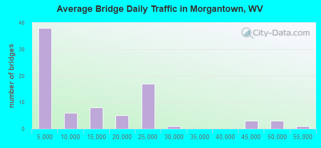
- 1,022,366Total average daily traffic
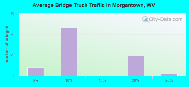
- 126,359Total average daily truck traffic
- National Bridge Inventory (NBI) Registered Bridges for Morgantown
- No street view available for this location
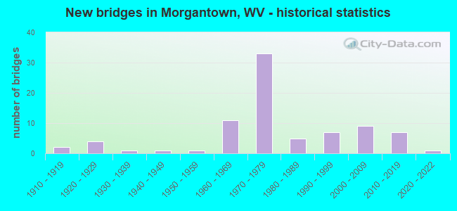
- New bridges - historical statistics
- 21910-1919
- 41920-1929
- 11930-1939
- 11940-1949
- 11950-1959
- 111960-1969
- 331970-1979
- 51980-1989
- 71990-1999
- 92000-2009
- 72010-2019
- 12020-2022
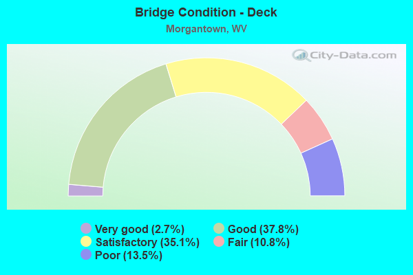
- Bridge Condition - Deck
- 2.7%Very good
- 37.8%Good
- 35.1%Satisfactory
- 10.8%Fair
- 13.5%Poor
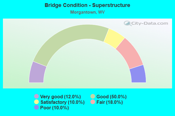
- Bridge Condition - Superstructure
- 12.0%Very good
- 50.0%Good
- 10.0%Satisfactory
- 18.0%Fair
- 10.0%Poor

- Bridge Condition - Substructure
- 6.3%Very good
- 37.5%Good
- 25.0%Satisfactory
- 25.0%Fair
- 6.3%Poor
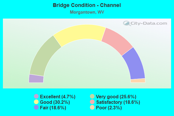
- Bridge Condition - Channel
- 4.7%Excellent
- 25.6%Very good
- 30.2%Good
- 18.6%Satisfactory
- 18.6%Fair
- 2.3%Poor
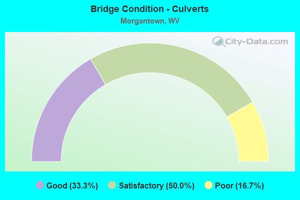
- Bridge Condition - Culverts
- 33.3%Good
- 50.0%Satisfactory
- 16.7%Poor
Find on map >> Show street view
Structure Number: 31A278, Location: 0.24 MI SOUTH WV RT 7 (Lat: 39.618200, Lng: -79.924989), Route carried "on" structure: County highway 6403, Year Built: 1970, Status: Open, Structure Length: 2.82m (9.25ft), Average Daily Traffic: 7,500 (year 2019), Truck Traffic: 6%, Average Future Daily Traffic: 11,625 (year 2041), Design Load: HS 20, Features Intersected: DECKERS CREEK, Facility Carried by Structure: MON CO RT 64/3
Minimum Vertical Clearance: 30+ m (98+ ft), Kilometerpoint: 1.046, Lanes on structure: 2, Owner: State Highway Agency, Approaching Roadway Width: 7.3m (24.0ft), Skew: 2 degrees, Material/Design: Steel continuous, Design/Construction: Stringer/Multi-beam, Number Of Spans In Main Unit: 2, Length of Maximum Span: 13.4m (44.0ft), Curb-To-Curb Width: 6.1m (20.0ft), Out-to-Out Width: 6.8m (22.3ft)
Condition: Deck: Satisfactory, Superstructure: Good, Substructure: Good, Channel: Satisfactory, Operating Rating: 46.3 metric tons, Method Used To Determine Operating Rating: Load Factor (LF), Inventory Rating: 28.1 metric tons, Method Used To Determine Inventory Rating: Load Factor (LF), Structural Evaluation: Better than present minimum criteria, Deck Geometry: High priority of replacement, Waterway Adequacy: Equal to present minimum criteria, Approach Roadway Alignment: Meets minimum limits, Designated Inspection Frequency: Every 24 months, Inspection Date: August 2021, Deck Structure Type: Concrete Cast-file-Place, Wearing Surface/Protective System: Wearing Surface: Monolithic Concrete
Find on map >> Show street view
Structure Number: 31A28, Location: 0.06 MI WEST CO RT 64/1 (Lat: 39.600039, Lng: -79.931831), Route carried "on" structure: County highway 6404, Year Built: 2001, Status: Open, Structure Length: 1.27m (4.17ft), Average Daily Traffic: 50 (year 2018), Average Future Daily Traffic: 65 (year 2038), Design Load: HS 25 or greater, Features Intersected: AARON CREEK, Facility Carried by Structure: MON CO RT 64/4
Minimum Vertical Clearance: 30+ m (98+ ft), Kilometerpoint: 0.097, Lanes on structure: 1, Owner: State Highway Agency, Approaching Roadway Width: 3.0m (9.8ft), Material/Design: Prestressed concrete, Design/Construction: Box Beam or Girders - Multiple, Number Of Spans In Main Unit: 1, Length of Maximum Span: 11.6m (38.1ft), Curb-To-Curb Width: 4.6m (15.1ft), Out-to-Out Width: 4.6m (15.1ft)
Condition: Deck: Good, Superstructure: Good, Substructure: Very good, Channel: Very good, Operating Rating: 80.7 metric tons, Method Used To Determine Operating Rating: Load Factor (LF), Inventory Rating: 49.0 metric tons, Method Used To Determine Inventory Rating: Load Factor (LF), Structural Evaluation: Better than present minimum criteria, Deck Geometry: Better than present minimum criteria, Waterway Adequacy: Better than present minimum criteria, Approach Roadway Alignment: Better than present minimum criteria, Designated Inspection Frequency: Every 48 months, Inspection Date: April 2020, Deck Structure Type: Other, Wearing Surface/Protective System: Deck Protection: Epoxy Coated Reinforcing
Find on map >> Show street view
Structure Number: 31A281, Location: 0.12 MILES NORTH US 119 (Lat: 39.626300, Lng: -79.958900), Route carried "on" structure: County highway 11939, Year Built: 2001, Status: Open, Structure Length: 16.78m (55.05ft), Average Daily Traffic: 5,500 (year 2018), Truck Traffic: 6%, Average Future Daily Traffic: 7,475 (year 2038), Design Load: HS 25 or greater, Features Intersected: DECKERS CREEK, Facility Carried by Structure: MGL CO RT 119/39
Minimum Vertical Clearance: 30+ m (98+ ft), Kilometerpoint: 0.193, Lanes on structure: 2, Owner: State Highway Agency, Approaching Roadway Width: 8.2m (26.9ft), Material/Design: Steel continuous, Design/Construction: Stringer/Multi-beam, Number Of Spans In Main Unit: 4, Number Of Approach Spans: 1, Length of Maximum Span: 36.6m (120.1ft), Curb or Sidewalk Widths: Left: 1.8m (5.9ft), Right: 1.8m (5.9ft), Curb-To-Curb Width: 8.2m (26.9ft), Out-to-Out Width: 12.8m (42.0ft)
Condition: Deck: Good, Superstructure: Good, Substructure: Good, Channel: Very good, Operating Rating: 64.4 metric tons, Method Used To Determine Operating Rating: Load Factor (LF), Inventory Rating: 38.1 metric tons, Method Used To Determine Inventory Rating: Load Factor (LF), Structural Evaluation: Better than present minimum criteria, Deck Geometry: High priority of corrective action, Waterway Adequacy: Superior to present desirable criteria, Approach Roadway Alignment: Equal to present desirable criteria, Length Of Structure Improvement: 16.76m (54.99ft), Designated Inspection Frequency: Every 24 months, Inspection Date: January 2020, Bridge Improvement Cost: $1,064,000, Roadway Improvement Cost: $828,000, Total Project Cost: $1,961,000 ( Estimate for 2020), Deck Structure Type: Concrete Cast-file-Place, Wearing Surface/Protective System: Wearing Surface: Latex Concrete, Deck Protection: Epoxy Coated Reinforcing
Find on map >> Show street view
Structure Number: 31A282, Location: 0.01 MI WEST WV RT 100 (Lat: 39.700681, Lng: -79.997061), Route carried "on" structure: County highway 5800, Year Built: 2002, Status: Open, Structure Length: 1.12m (3.67ft), Average Daily Traffic: 50 (year 2018), Average Future Daily Traffic: 65 (year 2038), Design Load: HS 25 or greater, Features Intersected: ROBINSON RUN, Facility Carried by Structure: COUNTY ROUTE 58
Minimum Vertical Clearance: 30+ m (98+ ft), Kilometerpoint: 0.016, Lanes on structure: 2, Owner: State Highway Agency, Approaching Roadway Width: 4.9m (16.1ft), Material/Design: Prestressed concrete, Design/Construction: Box Beam or Girders - Multiple, Number Of Spans In Main Unit: 1, Length of Maximum Span: 9.8m (32.2ft), Curb-To-Curb Width: 6.3m (20.7ft), Out-to-Out Width: 6.5m (21.3ft)
Condition: Deck: Good, Superstructure: Good, Substructure: Good, Channel: Very good, Operating Rating: 80.7 metric tons, Method Used To Determine Operating Rating: Load Factor (LF), Inventory Rating: 48.1 metric tons, Method Used To Determine Inventory Rating: Load Factor (LF), Structural Evaluation: Better than present minimum criteria, Deck Geometry: Somewhat better than minimum adequacy, Waterway Adequacy: Better than present minimum criteria, Approach Roadway Alignment: Better than present minimum criteria, Designated Inspection Frequency: Every 48 months, Inspection Date: December 2020, Deck Structure Type: Other, Wearing Surface/Protective System: Deck Protection: Epoxy Coated Reinforcing
Find on map >> Show street view
Structure Number: 31A285, Location: 0.08 MI WEST MON CO 857 (Lat: 39.616211, Lng: -79.932831), Route carried "on" structure: County highway 6402, Year Built: 2002, Status: Open, Structure Length: 1.27m (4.17ft), Average Daily Traffic: 50 (year 2021), Average Future Daily Traffic: 70 (year 2041), Design Load: HS 25 or greater, Features Intersected: AARON CREEK, Facility Carried by Structure: MONONGALIA CO 64/2
Minimum Vertical Clearance: 30+ m (98+ ft), Kilometerpoint: 0.129, Lanes on structure: 2, Owner: State Highway Agency, Approaching Roadway Width: 3.7m (12.1ft), Skew: 2 degrees, Material/Design: Prestressed concrete, Design/Construction: Box Beam or Girders - Multiple, Number Of Spans In Main Unit: 1, Length of Maximum Span: 11.6m (38.1ft), Curb-To-Curb Width: 6.3m (20.7ft), Out-to-Out Width: 6.5m (21.3ft)
Condition: Superstructure: Very good, Substructure: Very good, Channel: Good, Operating Rating: 75.3 metric tons, Method Used To Determine Operating Rating: Load Factor (LF), Inventory Rating: 45.4 metric tons, Method Used To Determine Inventory Rating: Load Factor (LF), Structural Evaluation: Equal to present desirable criteria, Deck Geometry: Somewhat better than minimum adequacy, Waterway Adequacy: Better than present minimum criteria, Approach Roadway Alignment: Better than present minimum criteria, Designated Inspection Frequency: Every 48 months, Inspection Date: Febuary 2021, Deck Structure Type: Other, Wearing Surface/Protective System: Wearing Surface: Bituminous, Deck Protection: Epoxy Coated Reinforcing
Find on map >> Show street view
Structure Number: 31A288, Location: 0.04 MI NORTH MGL CO 53 (Lat: 39.681950, Lng: -79.977839), Route carried "on" structure: State highway 10000, Year Built: 2003, Status: Open, Structure Length: 1.10m (3.61ft), Average Daily Traffic: 2,900 (year 2019), Truck Traffic: 6%, Average Future Daily Traffic: 3,740 (year 2041), Design Load: HL 93, Features Intersected: ROBINSON RUN, Facility Carried by Structure: WV ROUTE 100
Minimum Vertical Clearance: 30+ m (98+ ft), Kilometerpoint: 6.389, Lanes on structure: 2, Owner: State Highway Agency, Approaching Roadway Width: 9.1m (29.9ft), Skew: 3 degrees, Material/Design: Concrete, Design/Construction: Frame, Number Of Spans In Main Unit: 1, Length of Maximum Span: 9.7m (31.8ft), Curb-To-Curb Width: 8.4m (27.6ft), Out-to-Out Width: 9.1m (29.9ft)
Condition: Deck: Good, Superstructure: Good, Substructure: Good, Channel: Good, Operating Rating: 88.9 metric tons, Method Used To Determine Operating Rating: Field evaluation and documented engineering judgment, Inventory Rating: 40.8 metric tons, Method Used To Determine Inventory Rating: Field evaluation and documented engineering judgment, Structural Evaluation: Better than present minimum criteria, Deck Geometry: High priority of corrective action, Waterway Adequacy: Equal to present minimum criteria, Approach Roadway Alignment: Somewhat better than minimum adequacy, Designated Inspection Frequency: Every 48 months, Inspection Date: May 2021, Deck Structure Type: Concrete Cast-file-Place, Wearing Surface/Protective System: Deck Protection: Epoxy Coated Reinforcing
Find on map >> Show street view
Structure Number: 31A289, Location: 0.33 MI NORTH MGL CO 53 (Lat: 39.682950, Lng: -79.978981), Route carried "on" structure: State highway 10000, Year Built: 2003, Status: Open, Structure Length: 0.98m (3.22ft), Average Daily Traffic: 2,900 (year 2019), Truck Traffic: 6%, Average Future Daily Traffic: 3,740 (year 2041), Design Load: HL 93, Features Intersected: ROBINSON RUN, Facility Carried by Structure: WV ROUTE 100
Minimum Vertical Clearance: 30+ m (98+ ft), Kilometerpoint: 6.856, Lanes on structure: 2, Owner: State Highway Agency, Approaching Roadway Width: 9.1m (29.9ft), Skew: 2 degrees, Material/Design: Concrete, Design/Construction: Frame, Number Of Spans In Main Unit: 1, Length of Maximum Span: 8.7m (28.5ft), Curb-To-Curb Width: 8.4m (27.6ft), Out-to-Out Width: 9.1m (29.9ft)
Condition: Deck: Good, Superstructure: Good, Substructure: Good, Channel: Very good, Operating Rating: 88.9 metric tons, Method Used To Determine Operating Rating: Field evaluation and documented engineering judgment, Inventory Rating: 40.8 metric tons, Method Used To Determine Inventory Rating: Field evaluation and documented engineering judgment, Structural Evaluation: Better than present minimum criteria, Deck Geometry: High priority of corrective action, Waterway Adequacy: Equal to present minimum criteria, Approach Roadway Alignment: Equal to present minimum criteria, Designated Inspection Frequency: Every 48 months, Inspection Date: May 2021, Deck Structure Type: Concrete Cast-file-Place, Wearing Surface/Protective System: Deck Protection: Epoxy Coated Reinforcing
Find on map >> Show street view
Structure Number: 31A295, Location: 0.07 MI EAST MGL CO 7/40 (Lat: 39.623239, Lng: -79.924050), Route carried "on" structure: State highway 700, Year Built: 2005, Status: Open, Structure Length: 1.23m (4.04ft), Average Daily Traffic: 4,700 (year 2019), Truck Traffic: 6%, Average Future Daily Traffic: 6,060 (year 2041), Design Load: HL 93, Features Intersected: KNOCKING RUN, Facility Carried by Structure: WV ROUTE 7
Minimum Vertical Clearance: 30+ m (98+ ft), Kilometerpoint: 57.228, Lanes on structure: 3, Owner: State Highway Agency, Approaching Roadway Width: 13.4m (44.0ft), Skew: 2 degrees, Material/Design: Concrete continuous, Design/Construction: Frame, Number Of Spans In Main Unit: 2, Length of Maximum Span: 5.7m (18.7ft), Curb-To-Curb Width: 14.1m (46.3ft), Out-to-Out Width: 14.8m (48.6ft)
Condition: Superstructure: Good, Substructure: Good, Channel: Fair, Operating Rating: 88.9 metric tons, Method Used To Determine Operating Rating: Field evaluation and documented engineering judgment, Inventory Rating: 40.8 metric tons, Method Used To Determine Inventory Rating: Field evaluation and documented engineering judgment, Structural Evaluation: Better than present minimum criteria, Deck Geometry: Somewhat better than minimum adequacy, Waterway Adequacy: Equal to present minimum criteria, Approach Roadway Alignment: Equal to present desirable criteria, Designated Inspection Frequency: Every 24 months, Inspection Date: April 2021, Deck Structure Type: Concrete Cast-file-Place, Wearing Surface/Protective System: Deck Protection: Epoxy Coated Reinforcing
Find on map >> Show street view
Structure Number: 31A299, Location: 0.80 MI SOUTH CO RT 77/2 (Lat: 39.560689, Lng: -79.959869), Route carried "on" structure: County highway 7701, Year Built: 2006, Status: Open, Structure Length: 0.76m (2.49ft), Average Daily Traffic: 300 (year 2019), Truck Traffic: 6%, Average Future Daily Traffic: 400 (year 2039), Design Load: HL 93, Features Intersected: BLOODY RUN, Facility Carried by Structure: MGL CO RT 77/1
Minimum Vertical Clearance: 30+ m (98+ ft), Kilometerpoint: 2.092, Lanes on structure: 1, Owner: State Highway Agency, Approaching Roadway Width: 2.7m (8.9ft), Skew: 5 degrees, Material/Design: Concrete, Design/Construction: Frame, Number Of Spans In Main Unit: 1, Length of Maximum Span: 6.7m (22.0ft), Curb-To-Curb Width: 4.7m (15.4ft), Out-to-Out Width: 5.5m (18.0ft)
Condition: Superstructure: Good, Substructure: Good, Channel: Satisfactory, Operating Rating: 88.9 metric tons, Method Used To Determine Operating Rating: Field evaluation and documented engineering judgment, Inventory Rating: 40.8 metric tons, Method Used To Determine Inventory Rating: Field evaluation and documented engineering judgment, Structural Evaluation: Better than present minimum criteria, Deck Geometry: High priority of replacement, Waterway Adequacy: Equal to present minimum criteria, Approach Roadway Alignment: Equal to present desirable criteria, Length Of Structure Improvement: 0.76m (2.49ft), Designated Inspection Frequency: Every 24 months, Inspection Date: January 2021, Bridge Improvement Cost: $181,000, Roadway Improvement Cost: $101,000, Total Project Cost: $307,000 ( Estimate for 2021), Deck Structure Type: Concrete Cast-file-Place, Wearing Surface/Protective System: Deck Protection: Epoxy Coated Reinforcing
Find on map >> Show street view
Structure Number: 31A301, Location: 0.36 MI WEST MGL CO RT 59 (Lat: 39.669789, Lng: -79.964411), Route carried "on" structure: County highway 5903, Year Built: 2007, Status: Open, Structure Length: 0.86m (2.82ft), Average Daily Traffic: 100 (year 2019), Average Future Daily Traffic: 155 (year 2041), Design Load: HS 25 or greater, Features Intersected: WEST RUN, Facility Carried by Structure: MONONGALIA CO 59/3
Minimum Vertical Clearance: 30+ m (98+ ft), Kilometerpoint: 0.579, Lanes on structure: 1, Owner: State Highway Agency, Approaching Roadway Width: 3.4m (11.2ft), Skew: 1 degrees, Material/Design: Steel, Design/Construction: Stringer/Multi-beam, Number Of Spans In Main Unit: 1, Length of Maximum Span: 7.6m (24.9ft), Curb-To-Curb Width: 4.2m (13.8ft), Out-to-Out Width: 4.2m (13.8ft)
Condition: Deck: Satisfactory, Superstructure: Very good, Substructure: Satisfactory, Channel: Good, Operating Rating: 68.9 metric tons, Method Used To Determine Operating Rating: Load Factor (LF), Inventory Rating: 41.7 metric tons, Method Used To Determine Inventory Rating: Load Factor (LF), Structural Evaluation: Equal to present minimum criteria, Deck Geometry: Somewhat better than minimum adequacy, Waterway Adequacy: Better than present minimum criteria, Approach Roadway Alignment: Somewhat better than minimum adequacy, Designated Inspection Frequency: Every 24 months, Inspection Date: August 2021, Deck Structure Type: Wood or Timber
Find on map >> Show street view
Structure Number: 31A322, Location: .02 mi. S. of Mon. Co. 64 (Lat: 39.626200, Lng: -79.930500), Route carried "on" structure: County highway 857, Year Built: 2011, Status: Open, Structure Length: 2.28m (7.48ft), Average Daily Traffic: 9,900 (year 2019), Truck Traffic: 6%, Average Future Daily Traffic: 15,345 (year 2041), Design Load: HL 93, Features Intersected: DECKERS CREEK
Minimum Vertical Clearance: 30+ m (98+ ft), Kilometerpoint: 5.311, Lanes on structure: 2, Owner: State Highway Agency, Approaching Roadway Width: 9.8m (32.2ft), Material/Design: Prestressed concrete, Design/Construction: Box Beam or Girders - Multiple, Number Of Spans In Main Unit: 1, Length of Maximum Span: 21.6m (70.9ft), Curb-To-Curb Width: 8.1m (26.6ft), Out-to-Out Width: 8.9m (29.2ft)
Condition: Deck: Very good, Superstructure: Very good, Substructure: Good, Channel: Very good, Operating Rating: 88.9 metric tons, Method Used To Determine Operating Rating: Load and Resistance Factor (LRFR), Inventory Rating: 69.8 metric tons, Method Used To Determine Inventory Rating: Load and Resistance Factor (LRFR), Structural Evaluation: Better than present minimum criteria, Deck Geometry: High priority of replacement, Waterway Adequacy: Equal to present minimum criteria, Approach Roadway Alignment: High priority of corrective action, Length Of Structure Improvement: 2.29m (7.51ft), Designated Inspection Frequency: Every 24 months, Inspection Date: October 2021, Bridge Improvement Cost: $207,000, Roadway Improvement Cost: $91,000, Total Project Cost: $354,000 ( Estimate for 2022), Deck Structure Type: Concrete Cast-file-Place, Wearing Surface/Protective System: Deck Protection: Epoxy Coated Reinforcing
Find on map >> Show street view
Structure Number: 31A326, Location: 0.60 Mi W of Mon CR 81 (Lat: 39.591631, Lng: -79.941219), Route carried "on" structure: County highway 811, Year Built: 2014, Status: Open, Structure Length: 1.33m (4.36ft), Average Daily Traffic: 10 (year 2018), Average Future Daily Traffic: 14 (year 2038), Design Load: HL 93, Features Intersected: Cobun Creek, Facility Carried by Structure: Mon Co 81/1
Minimum Vertical Clearance: 30+ m (98+ ft), Kilometerpoint: 0.966, Lanes on structure: 1, Owner: State Highway Agency, Approaching Roadway Width: 4.9m (16.1ft), Material/Design: Prestressed concrete, Design/Construction: Box Beam or Girders - Multiple, Number Of Spans In Main Unit: 1, Length of Maximum Span: 12.2m (40.0ft), Curb-To-Curb Width: 4.6m (15.1ft), Out-to-Out Width: 4.7m (15.4ft)
Condition: Superstructure: Very good, Substructure: Very good, Channel: Good, Operating Rating: 59.0 metric tons, Method Used To Determine Operating Rating: Load and Resistance Factor (LRFR), Inventory Rating: 45.4 metric tons, Method Used To Determine Inventory Rating: Load and Resistance Factor (LRFR), Structural Evaluation: Equal to present desirable criteria, Deck Geometry: Better than present minimum criteria, Waterway Adequacy: Equal to present minimum criteria, Approach Roadway Alignment: Better than present minimum criteria, Designated Inspection Frequency: Every 48 months, Inspection Date: May 2020, Deck Structure Type: Concrete Precast Panels, Wearing Surface/Protective System: Wearing Surface: Bituminous, Membrane: Preformed Fabric, Deck Protection: Epoxy Coated Reinforcing
Find on map >> Show street view
Structure Number: 31A329, Location: 0.16 mi E of Mon Co 46/3 (Lat: 39.639500, Lng: -80.002000), Route carried "on" structure: County highway 467, Year Built: 2016, Status: Open, Structure Length: 7.92m (25.98ft), Average Daily Traffic: 6,000 (year 2020), Truck Traffic: 6%, Average Future Daily Traffic: 8,150 (year 2039), Design Load: HL 93, Features Intersected: I-79, Facility Carried by Structure: MON CO 46/7
Minimum Vertical Clearance: 30+ m (98+ ft), Kilometerpoint: 0.257, Lanes on structure: 4, Lanes under structure: 4, Owner: State Highway Agency, Approaching Roadway Width: 22.3m (73.2ft), Material/Design: Concrete continuous, Design/Construction: Box Beam or Girders - Multiple, Number Of Spans In Main Unit: 1, Number Of Approach Spans: 1, Length of Maximum Span: 41.8m (137.1ft), Curb or Sidewalk Widths: Left: 0.0m, Right: 1.5m (4.9ft), Curb-To-Curb Width: 23.8m (78.1ft), Out-to-Out Width: 26.0m (85.3ft)
Condition: Deck: Good, Superstructure: Good, Substructure: Good, Operating Rating: 51.7 metric tons, Method Used To Determine Operating Rating: Load and Resistance Factor (LRFR), Inventory Rating: 39.9 metric tons, Method Used To Determine Inventory Rating: Load and Resistance Factor (LRFR), Structural Evaluation: Better than present minimum criteria, Deck Geometry: Superior to present desirable criteria, Underclear: Equal to present desirable criteria, Approach Roadway Alignment: Equal to present desirable criteria, Designated Inspection Frequency: Every 24 months, Inspection Date: November 2020, Deck Structure Type: Other
Find on map >> Show street view
Structure Number: 31A331, Location: 0.08 S. Mon. Co. 119/17 (Lat: 39.652600, Lng: -79.914700), Route carried "on" structure: US 119, Year Built: 2017, Status: Open, Structure Length: 0.95m (3.12ft), Average Daily Traffic: 19,200 (year 2018), Truck Traffic: 4%, Average Future Daily Traffic: 26,100 (year 2038), Design Load: HL 93, Features Intersected: West Run
Minimum Vertical Clearance: 30+ m (98+ ft), Kilometerpoint: 27.954, Lanes on structure: 4, Owner: State Highway Agency, Approaching Roadway Width: 15.5m (50.9ft), Skew: 4 degrees, Material/Design: Concrete, Design/Construction: Culvert, Number Of Spans In Main Unit: 1, Length of Maximum Span: 8.6m (28.2ft)
Condition: Culverts: Good, Operating Rating: 88.9 metric tons, Method Used To Determine Operating Rating: Field evaluation and documented engineering judgment, Inventory Rating: 40.8 metric tons, Method Used To Determine Inventory Rating: Field evaluation and documented engineering judgment, Structural Evaluation: Better than present minimum criteria, Waterway Adequacy: Better than present minimum criteria, Approach Roadway Alignment: Equal to present desirable criteria, Designated Inspection Frequency: Every 24 months, Inspection Date: October 2021, Wearing Surface/Protective System: Wearing Surface: Bituminous, Membrane: Built-up
Find on map >> Show street view
Structure Number: 31A904, Location: 0.03 MI SOUTH CO RT 64 (Lat: 39.628819, Lng: -79.934589), Route carried "on" structure: City street N1095, Year Built: 1960, Status: Open, Structure Length: 2.13m (6.99ft), Average Daily Traffic: 2,000 (year 2019), Truck Traffic: 6%, Average Future Daily Traffic: 2,725 (year 2041), Features Intersected: DECKERS CREEK, Facility Carried by Structure: WHITE AVENUE
Minimum Vertical Clearance: 30+ m (98+ ft), Kilometerpoint: 0.016, Lanes on structure: 2, Owner: City or Municipal Highway Agency, Approaching Roadway Width: 6.7m (22.0ft), Skew: 3 degrees, Material/Design: Concrete, Design/Construction: Culvert, Number Of Spans In Main Unit: 1, Number Of Approach Spans: 2, Length of Maximum Span: 8.2m (26.9ft), Curb-To-Curb Width: 10.2m (33.5ft), Out-to-Out Width: 12.4m (40.7ft)
Condition: Channel: Fair, Culverts: Satisfactory, Operating Rating: 63.5 metric tons, Method Used To Determine Operating Rating: Field evaluation and documented engineering judgment, Inventory Rating: 29.0 metric tons, Method Used To Determine Inventory Rating: Field evaluation and documented engineering judgment, Structural Evaluation: Equal to present minimum criteria, Deck Geometry: Somewhat better than minimum adequacy, Waterway Adequacy: Meets minimum limits, Approach Roadway Alignment: Equal to present minimum criteria, Designated Inspection Frequency: Every 24 months, Inspection Date: May 2021
Find on map >> Show street view
Structure Number: 31A905, Location: 0.02 MI EAST CO RT 7/40 (Lat: 39.623161, Lng: -79.921831), Route carried "on" structure: County highway 687, Year Built: 1912, Status: Open, Structure Length: 0.94m (3.08ft), Average Daily Traffic: 750 (year 2019), Truck Traffic: 6%, Average Future Daily Traffic: 1,025 (year 2041), Features Intersected: KNOCKING RUN, Facility Carried by Structure: MON CO RT. 68/7
Minimum Vertical Clearance: 30+ m (98+ ft), Kilometerpoint: 0.032, Lanes on structure: 2, Owner: State Highway Agency, Approaching Roadway Width: 5.8m (19.0ft), Material/Design: Concrete, Design/Construction: Arch - Deck, Number Of Spans In Main Unit: 1, Length of Maximum Span: 9.4m (30.8ft), Curb-To-Curb Width: 5.3m (17.4ft), Out-to-Out Width: 6.1m (20.0ft)
Condition: Superstructure: Poor, Channel: Good, Operating Rating: 47.2 metric tons, Method Used To Determine Operating Rating: Field evaluation and documented engineering judgment, Inventory Rating: 21.8 metric tons, Method Used To Determine Inventory Rating: Field evaluation and documented engineering judgment, Structural Evaluation: Meets minimum limits, Deck Geometry: High priority of replacement, Waterway Adequacy: Equal to present minimum criteria, Approach Roadway Alignment: Better than present minimum criteria, Length Of Structure Improvement: 1.68m (5.51ft), Designated Inspection Frequency: Every 24 months, Inspection Date: May 2021, Bridge Improvement Cost: $233,000, Roadway Improvement Cost: $171,000, Total Project Cost: $584,000 ( Estimate for 2021)
Find on map >> Show street view
Structure Number: 31A906, Location: 0.05 MI EAST CO RT 7/40 (Lat: 39.623300, Lng: -79.922681), Route carried "on" structure: County highway 687, Year Built: 1974, Status: Open, Structure Length: 1.07m (3.51ft), Average Daily Traffic: 200 (year 2019), Truck Traffic: 6%, Average Future Daily Traffic: 310 (year 2041), Features Intersected: KNOCKING RUN, Facility Carried by Structure: MON. CO. RT. 68/7
Minimum Vertical Clearance: 30+ m (98+ ft), Kilometerpoint: 0.080, Lanes on structure: 2, Owner: State Highway Agency, Approaching Roadway Width: 4.9m (16.1ft), Skew: 4 degrees, Material/Design: Steel, Design/Construction: Stringer/Multi-beam, Number Of Spans In Main Unit: 1, Length of Maximum Span: 9.2m (30.2ft), Curb-To-Curb Width: 6.0m (19.7ft), Out-to-Out Width: 7.8m (25.6ft)
Condition: Deck: Satisfactory, Superstructure: Satisfactory, Substructure: Satisfactory, Channel: Satisfactory, Operating Rating: 51.7 metric tons, Method Used To Determine Operating Rating: Load Factor (LF), Inventory Rating: 30.8 metric tons, Method Used To Determine Inventory Rating: Load Factor (LF), Structural Evaluation: Equal to present minimum criteria, Deck Geometry: High priority of corrective action, Waterway Adequacy: Equal to present minimum criteria, Approach Roadway Alignment: High priority of corrective action, Length Of Structure Improvement: 1.68m (5.51ft), Designated Inspection Frequency: Every 24 months, Inspection Date: May 2021, Bridge Improvement Cost: $312,000, Roadway Improvement Cost: $254,000, Total Project Cost: $571,000 ( Estimate for 2021), Deck Structure Type: Concrete Cast-file-Place, Wearing Surface/Protective System: Wearing Surface: Bituminous
Find on map >> Show street view
Structure Number: 31A907, Location: 0.15 mi E of Mon. Co. 857 (Lat: 39.630931, Lng: -79.929600), Route carried "on" structure: County highway 770, Year Built: 2015, Status: Open, Structure Length: 9.30m (30.51ft), Average Daily Traffic: 2,000 (year 2019), Truck Traffic: 6%, Average Future Daily Traffic: 3,100 (year 2041), Design Load: HL 93, Features Intersected: Mon.Co. 857, Hartman Run, Facility Carried by Structure: Mon. Co. 7/70
Minimum Vertical Clearance: 30+ m (98+ ft), Kilometerpoint: 0.660, Lanes on structure: 2, Lanes under structure: 2, Owner: State Highway Agency, Approaching Roadway Width: 9.4m (30.8ft), Material/Design: Prestressed concrete continuous, Design/Construction: Stringer/Multi-beam, Number Of Spans In Main Unit: 1, Number Of Approach Spans: 2, Length of Maximum Span: 36.6m (120.1ft), Curb or Sidewalk Widths: Left: 0.0m, Right: 1.7m (5.6ft), Curb-To-Curb Width: 9.4m (30.8ft), Out-to-Out Width: 11.7m (38.4ft)
Condition: Deck: Good, Superstructure: Good, Substructure: Good, Channel: Very good, Operating Rating: 48.1 metric tons, Method Used To Determine Operating Rating: Load and Resistance Factor (LRFR), Inventory Rating: 37.2 metric tons, Method Used To Determine Inventory Rating: Load and Resistance Factor (LRFR), Structural Evaluation: Better than present minimum criteria, Deck Geometry: Somewhat better than minimum adequacy, Underclear: High priority of corrective action, Waterway Adequacy: Superior to present desirable criteria, Approach Roadway Alignment: Equal to present desirable criteria, Designated Inspection Frequency: Every 24 months, Inspection Date: September 2021, Deck Structure Type: Concrete Cast-file-Place, Wearing Surface/Protective System: Deck Protection: Epoxy Coated Reinforcing
Find on map >> Show street view
Structure Number: 31A052, Location: 0.01 MI SOUTH US RT 119 (Lat: 39.630581, Lng: -79.957639), Route carried "under" structure: US 1900, Year Built: 1972, Structure Length: 0. m, Average Daily Traffic: 21,700 (year 2019), Truck Traffic: 4%, Features Intersected: PUBLIC RAPID TRANSIT, Facility Carried by Structure: WVU PUBLIC TRANSIT
Minimum Vertical Clearance: 7.82m (25.66ft), Kilometerpoint: 18.250, Lanes under structure: 4, Length of Maximum Span: 21.3m (69.9ft)
Find on map >> Show street view
Structure Number: 31A053, Location: 0.19 MI NORTH US RT 119 (Lat: 39.635539, Lng: -79.956619), Route carried "under" structure: US 1900, Year Built: 1972, Structure Length: 0. m, Average Daily Traffic: 24,100 (year 2019), Truck Traffic: 4%, Features Intersected: PUBLIC RAPID TRANSIT, Facility Carried by Structure: WVU PUBLIC TRANSIT
Minimum Vertical Clearance: 6.10m (20.01ft), Kilometerpoint: 18.717, Lanes under structure: 2, Length of Maximum Span: 40.5m (132.9ft)
Find on map >> Show street view
Structure Number: 31A056, Location: 0.36 MI NORTH US RT 119 (Lat: 39.634369, Lng: -79.956539), Route carried "under" structure: US 1900, Year Built: 1972, Structure Length: 0. m, Average Daily Traffic: 24,100 (year 2019), Truck Traffic: 4%, Features Intersected: PUBLIC RAPID TRANSIT, Facility Carried by Structure: WVU PUBLIC TRANSIT
Minimum Vertical Clearance: 5.56m (18.24ft), Kilometerpoint: 18.829, Lanes under structure: 3, Length of Maximum Span: 46.9m (153.9ft)
Find on map >> Show street view
Structure Number: 31A057, Location: 0.28 MI SOUTH WV RT 705 (Lat: 39.645039, Lng: -79.975611), Route carried "under" structure: US 1900, Year Built: 1972, Structure Length: 0. m, Average Daily Traffic: 18,400 (year 2019), Truck Traffic: 4%, Features Intersected: PUBLIC RAPID TRANSIT, Facility Carried by Structure: WVU PUBLIC TRANSIT
Minimum Vertical Clearance: 5.74m (18.83ft), Kilometerpoint: 21.018, Lanes under structure: 4, Length of Maximum Span: 35.7m (117.1ft)
Find on map >> Show street view
Structure Number: 31A118, Location: 0.56 MI WEST I-68 (Lat: 39.578350, Lng: -79.976200), Route carried "under" structure: Ramp Interstate 6800, Year Built: 1970, Structure Length: 0. m, Average Daily Traffic: 10,850 (year 0017), Truck Traffic: 18%, Features Intersected: I-68 EB Ramp and I-79, Facility Carried by Structure: I-68 SOUTH
Minimum Vertical Clearance: 5.41m (17.75ft), Kilometerpoint: 0.805, Lanes on structure: 2, Lanes under structure: 2, Length of Maximum Span: 53.3m (174.9ft)
Find on map >> Show street view
Structure Number: 31A118, Location: 0.56 MI WEST I-68 (Lat: 39.578350, Lng: -79.976200), Route carried "under" structure: Interstate 7900, Year Built: 1970, Structure Length: 0. m, Average Daily Traffic: 50,275 (year 0017), Truck Traffic: 18%, Features Intersected: I-68 EB Ramp and I-79, Facility Carried by Structure: I-68 SOUTH
Minimum Vertical Clearance: 6.93m (22.74ft), Kilometerpoint: 239.486, Lanes on structure: 2, Lanes under structure: 4, Length of Maximum Span: 53.3m (174.9ft)
Find on map >> Show street view
Structure Number: 31A121, Location: 1.03 MI WEST WV RT 7 (Lat: 39.599689, Lng: -79.930481), Route carried "under" structure: County highway 6401, Year Built: 1971, Structure Length: 0. m, Average Daily Traffic: 550 (year 0016), Truck Traffic: 6%, Features Intersected: Mon. Co. Rt. 64/1, Facility Carried by Structure: INTERSTATE 68 WB
Minimum Vertical Clearance: 4.83m (15.85ft), Kilometerpoint: 1.609, Lanes on structure: 2, Lanes under structure: 2, Length of Maximum Span: 18.0m (59.1ft)
Find on map >> Show street view
Structure Number: 31A122, Location: 2.84 MI EAST US ROUTE 119 (Lat: 39.611300, Lng: -79.922911), Route carried "under" structure: State highway 700, Year Built: 1973, Structure Length: 0. m, Average Daily Traffic: 21,375 (year 0016), Truck Traffic: 7%, Features Intersected: Deckers Ck.& WV Rt.7, Facility Carried by Structure: INTERSTATE 68 WB
Minimum Vertical Clearance: 5.87m (19.26ft), Kilometerpoint: 58.516, Lanes on structure: 2, Lanes under structure: 2, Length of Maximum Span: 39.5m (129.6ft)
Find on map >> Show street view
Structure Number: 31A138, Location: 1.03 MI WEST WV RT 7 (Lat: 39.599650, Lng: -79.930239), Route carried "under" structure: County highway 6401, Year Built: 1971, Structure Length: 0. m, Average Daily Traffic: 500 (year 0018), Truck Traffic: 6%, Features Intersected: Mon. Co. Rt. 64/1, Facility Carried by Structure: INTERSTATE 68 EB
Minimum Vertical Clearance: 4.83m (15.85ft), Kilometerpoint: 1.609, Lanes on structure: 2, Lanes under structure: 2, Length of Maximum Span: 18.0m (59.1ft)
Find on map >> Show street view
Structure Number: 31A14, Location: 2.84 MI EAST US RT 119 (Lat: 39.611600, Lng: -79.922800), Route carried "under" structure: State highway 700, Year Built: 1973, Structure Length: 0. m, Average Daily Traffic: 22,600 (year 0018), Truck Traffic: 7%, Features Intersected: WV 7 Deckers Creek, Facility Carried by Structure: INTERSTATE 68 EB
Minimum Vertical Clearance: 6.96m (22.83ft), Kilometerpoint: 58.516, Lanes on structure: 2, Lanes under structure: 3, Length of Maximum Span: 35.8m (117.5ft)
Find on map >> Show street view
Structure Number: 31A163, Location: 0.47 MI SOUTH CO RT 77 (Lat: 39.531781, Lng: -79.997561), Route carried "under" structure: County highway 7904, Year Built: 1967, Structure Length: 0. m, Average Daily Traffic: 1,500 (year 0018), Truck Traffic: 6%, Features Intersected: MON CO 79/4, Facility Carried by Structure: INTERSTATE 79 NB
Minimum Vertical Clearance: 5.36m (17.59ft), Kilometerpoint: 2.575, Lanes on structure: 2, Lanes under structure: 2, Length of Maximum Span: 14.5m (47.6ft)
Find on map >> Show street view
Structure Number: 31A164, Location: 0.47 MI SOUTH CO RT 77 (Lat: 39.531919, Lng: -79.997739), Route carried "under" structure: County highway 7904, Year Built: 1967, Structure Length: 0. m, Average Daily Traffic: 1,500 (year 0018), Truck Traffic: 6%, Features Intersected: Mon. Co. 79/4, Facility Carried by Structure: INTERSTATE 79 SB
Minimum Vertical Clearance: 4.88m (16.01ft), Kilometerpoint: 2.575, Lanes on structure: 2, Lanes under structure: 2, Length of Maximum Span: 12.6m (41.3ft)
Find on map >> Show street view
Structure Number: 31A165, Location: 3.16 MI SOUTH I-68 (Lat: 39.537500, Lng: -79.993000), Route carried "under" structure: County highway 7700, Year Built: 1967, Structure Length: 0. m, Average Daily Traffic: 1,600 (year 0018), Truck Traffic: 6%, Features Intersected: Mon. Co. Rt. 77, Facility Carried by Structure: INTERSTATE 79 NB
Minimum Vertical Clearance: 5.23m (17.16ft), Kilometerpoint: 0.193, Lanes on structure: 2, Lanes under structure: 2, Length of Maximum Span: 15.6m (51.2ft)
Find on map >> Show street view
Structure Number: 31A166, Location: 3.16 MI SOUTH I-68 (Lat: 39.537600, Lng: -79.993300), Route carried "under" structure: County highway 7700, Year Built: 1967, Structure Length: 0. m, Average Daily Traffic: 1,600 (year 0018), Truck Traffic: 6%, Features Intersected: Mon. Co. Rt. 77, Facility Carried by Structure: INTERSTATE 79 SB
Minimum Vertical Clearance: 5.84m (19.16ft), Kilometerpoint: 0.193, Lanes on structure: 2, Lanes under structure: 2, Length of Maximum Span: 15.4m (50.5ft)
Find on map >> Show street view
Structure Number: 31A167, Location: 3.16 MI NORTH CO RT 77 (Lat: 39.578769, Lng: -79.976039), Route carried "under" structure: Ramp Interstate 6800, Year Built: 1970, Structure Length: 0. m, Average Daily Traffic: 12,075 (year 0019), Truck Traffic: 18%, Features Intersected: I-68 Eastbound On-Ramp, Facility Carried by Structure: INTERSTATE 79 NB
Minimum Vertical Clearance: 6.68m (21.92ft), Kilometerpoint: 0.805, Lanes on structure: 2, Lanes under structure: 2, Length of Maximum Span: 20.6m (67.6ft)
Find on map >> Show street view
Structure Number: 31A168, Location: 3.16 MI NORTH CO RT 77 (Lat: 39.578669, Lng: -79.976269), Route carried "under" structure: Interstate 6800, Year Built: 1970, Structure Length: 0. m, Average Daily Traffic: 12,075 (year 0019), Truck Traffic: 18%, Features Intersected: I-68 Eastbound On-Ramp, Facility Carried by Structure: INTERSTATE 79 SB
Minimum Vertical Clearance: 5.41m (17.75ft), Kilometerpoint: 0.805, Lanes on structure: 2, Lanes under structure: 2, Length of Maximum Span: 20.6m (67.6ft)
Find on map >> Show street view
Structure Number: 31A169, Location: 0.46 MILES NORTH I-68 (Lat: 39.584669, Lng: -79.979219), Route carried "under" structure: County highway 7300, Year Built: 1970, Structure Length: 0. m, Average Daily Traffic: 2,900 (year 0018), Truck Traffic: 6%, Features Intersected: Mon. Co. Rt. 73, Facility Carried by Structure: INTERSTATE 79
Minimum Vertical Clearance: 4.88m (16.01ft), Kilometerpoint: 12.376, Lanes on structure: 6, Lanes under structure: 2, Length of Maximum Span: 36.6m (120.1ft)
Find on map >> Show street view
Structure Number: 31A17, Location: 0.55 MILE NORTH OF I-68 (Lat: 39.588211, Lng: -79.979250), Route carried "under" structure: County highway 7307, Year Built: 1971, Structure Length: 0. m, Average Daily Traffic: 50 (year 0018), Features Intersected: Monongahela River, Facility Carried by Structure: INTERSTATE 79
Minimum Vertical Clearance: 29.92m (98.16ft), Kilometerpoint: 0.306, Lanes on structure: 5, Lanes under structure: 2, Length of Maximum Span: 146.3m (480.0ft)
Find on map >> Show street view
Structure Number: 31A17, Location: 0.55 MILE NORTH OF I-68 (Lat: 39.588211, Lng: -79.979250), Route carried "under" structure: County highway 459, Year Built: 1971, Structure Length: 0. m, Average Daily Traffic: 50 (year 0018), Truck Traffic: 6%, Features Intersected: Monongahela River, Facility Carried by Structure: INTERSTATE 79
Minimum Vertical Clearance: 4.75m (15.58ft), Kilometerpoint: 2.221, Lanes on structure: 5, Lanes under structure: 2, Length of Maximum Span: 146.3m (480.0ft)
Find on map >> Show street view
Structure Number: 31A187, Location: 0.45 MI SOUTH CR 53 (Lat: 39.675061, Lng: -79.980989), Route carried "under" structure: State highway 10000, Year Built: 1940, Structure Length: 0. m, Average Daily Traffic: 4,100 (year 2019), Truck Traffic: 7%, Features Intersected: WV 100, Facility Carried by Structure: MINE CONVEYOR BELT
Minimum Vertical Clearance: 12.19m (39.99ft), Kilometerpoint: 5.601, Lanes under structure: 2, Length of Maximum Span: 19.7m (64.6ft)
Find on map >> Show street view
Structure Number: 31A188, Location: 0.02 MI NORTH CO RT 53 (Lat: 39.678981, Lng: -79.978589), Route carried "under" structure: State highway 10000, Year Built: 1923, Structure Length: 0. m, Average Daily Traffic: 2,900 (year 2019), Truck Traffic: 7%, Features Intersected: NORFOLK SOUTHERN RR, Facility Carried by Structure: NORFOLK SOUTHERN
Minimum Vertical Clearance: 4.01m (13.16ft), Kilometerpoint: 6.357, Lanes under structure: 2, Length of Maximum Span: 9.4m (30.8ft)
Find on map >> Show street view
Structure Number: 31A195, Location: 0.25 MI NORTH CO RT 76 (Lat: 39.584031, Lng: -79.953719), Route carried "under" structure: Interstate 6800, Year Built: 1971, Structure Length: 0. m, Average Daily Traffic: 41,600 (year 0018), Truck Traffic: 18%, Features Intersected: I-68 EB & WB, Facility Carried by Structure: US ROUTE 119
Minimum Vertical Clearance: 11.89m (39.01ft), Kilometerpoint: 2.173, Lanes on structure: 4, Lanes under structure: 6, Length of Maximum Span: 29.6m (97.1ft)
Find on map >> Show street view
Structure Number: 31A26, Location: 0.12 MI NORTH WV RT 100 (Lat: 39.680139, Lng: -79.976750), Route carried "under" structure: County highway 5300, Year Built: 1980, Structure Length: 0. m, Average Daily Traffic: 3,000 (year 2019), Truck Traffic: 6%, Features Intersected: MINE CONVEYOR BELT, Facility Carried by Structure: MINE CONVEYOR BELT
Minimum Vertical Clearance: 9.14m (29.99ft), Kilometerpoint: 0.193, Lanes under structure: 2, Length of Maximum Span: 25.3m (83.0ft)
Find on map >> Show street view
Structure Number: 31A329, Location: 0.16 mi E of Mon Co 46/3 (Lat: 39.639500, Lng: -80.001600), Route carried "under" structure: County highway 4607, Year Built: 2016, Structure Length: 0. m, Average Daily Traffic: 44,100 (year 0018), Truck Traffic: 18%, Features Intersected: I-79, Facility Carried by Structure: MON CO 46/7
Minimum Vertical Clearance: 13.87m (45.51ft), Kilometerpoint: 246.712, Lanes on structure: 4, Lanes under structure: 4, Length of Maximum Span: 41.8m (137.1ft)
Find on map >> Show street view
Structure Number: 31A333, Location: 0.33 MI NORTH US RT 119 (Lat: 39.635011, Lng: -79.956589), Route carried "under" structure: US 19, Year Built: 2020, Structure Length: 0. m, Average Daily Traffic: 24,100 (year 2019), Truck Traffic: 4%, Features Intersected: Pedestrian Walkway, Facility Carried by Structure: Walkway
Minimum Vertical Clearance: 5.41m (17.75ft), Kilometerpoint: 18.781, Lanes under structure: 3, Length of Maximum Span: 22.1m (72.5ft)
Find on map >> Show street view
Structure Number: 31A907, Location: 0.15 mi E of Mon. Co. 857 (Lat: 39.630800, Lng: -79.929300), Route carried "under" structure: County highway 85700, Year Built: 2015, Structure Length: 0. m, Average Daily Traffic: 9,800 (year 2018), Truck Traffic: 6%, Features Intersected: Mon.Co. 857, Hartman Run, Facility Carried by Structure: Mon. Co. 7/70
Minimum Vertical Clearance: 13.72m (45.01ft), Kilometerpoint: 6.486, Lanes on structure: 2, Lanes under structure: 2, Length of Maximum Span: 36.6m (120.1ft)