Bridge Statistics for Morristown, Tennessee (TN)
Condition, Traffic, Stress, Structural Evaluation, Project Costs
- National Bridge Inventory (NBI) Statistics
- 155Number of bridges
- 1,581ft / 482mTotal length
- $103,177,000Total costs
- 2,001,117Total average daily traffic
- 461,219Total average daily truck traffic
- National Bridge Inventory (NBI) Registered Bridges for Morristown
- No street view available for this location
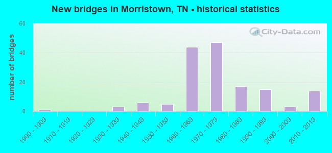
- New bridges - historical statistics
- 11900-1909
- 31930-1939
- 61940-1949
- 51950-1959
- 441960-1969
- 471970-1979
- 171980-1989
- 151990-1999
- 32000-2009
- 142010-2019
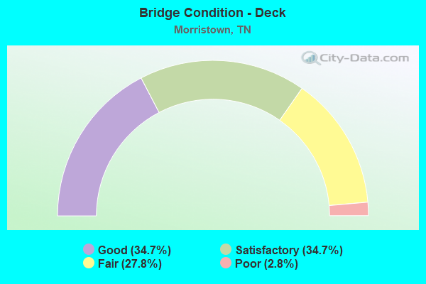
- Bridge Condition - Deck
- 34.7%Good
- 34.7%Satisfactory
- 27.8%Fair
- 2.8%Poor
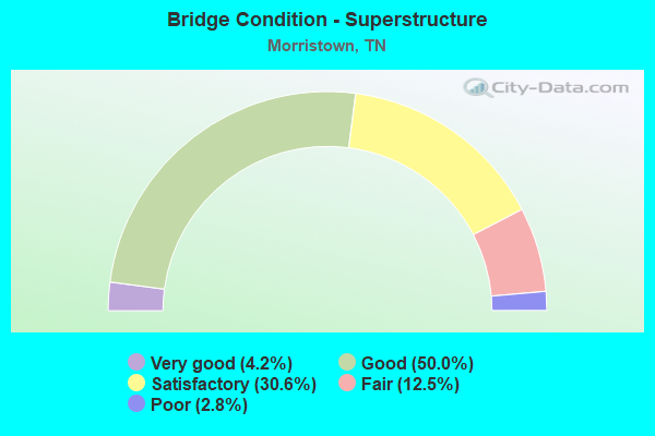
- Bridge Condition - Superstructure
- 4.2%Very good
- 50.0%Good
- 30.6%Satisfactory
- 12.5%Fair
- 2.8%Poor
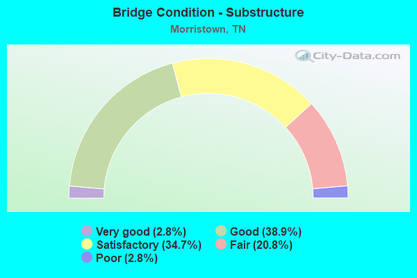
- Bridge Condition - Substructure
- 2.8%Very good
- 38.9%Good
- 34.7%Satisfactory
- 20.8%Fair
- 2.8%Poor
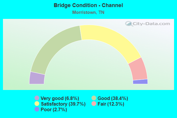
- Bridge Condition - Channel
- 6.8%Very good
- 38.4%Good
- 39.7%Satisfactory
- 12.3%Fair
- 2.7%Poor
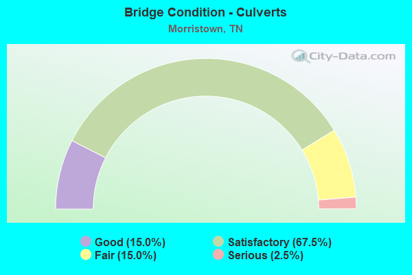
- Bridge Condition - Culverts
- 15.0%Good
- 67.5%Satisfactory
- 15.0%Fair
- 2.5%Serious
Find on map >> Show street view
Structure Number: 32SR032001, Location: SOUTH OF US-11E (Lat: 36.216800, Lng: -83.257233), Route carried "on" structure: US 32, Year Built: 2014, Status: Open, Structure Length: 3.58m (11.75ft), Average Daily Traffic: 23,467 (year 2020), Truck Traffic: 9%, Average Future Daily Traffic: 44,064 (year 2040), Design Load: HL 93, Features Intersected: RETAIL RD
Minimum Vertical Clearance: 30+ m (98+ ft), Kilometerpoint: 10.123, Lanes on structure: 4, Lanes under structure: 3, Base Highway Network: Yes, Owner: State Highway Agency, Approaching Roadway Width: 20.8m (68.2ft), Material/Design: Prestressed concrete continuous, Design/Construction: Stringer/Multi-beam, Number Of Spans In Main Unit: 1, Length of Maximum Span: 34.4m (112.9ft), Curb-To-Curb Width: 15.8m (51.8ft), Out-to-Out Width: 16.2m (53.1ft)
Condition: Deck: Good, Superstructure: Very good, Substructure: Good, Operating Rating: 44.1 metric tons, Method Used To Determine Operating Rating: Assigned ratings based on Load and Resistance Factor Design (LRFD) reported by rating factor (RF) using HL93 loadings, Inventory Rating: 32.4 metric tons, Method Used To Determine Inventory Rating: Assigned ratings based on Load and Resistance Factor Design (LRFD) reported by rating factor (RF) using HL93 loadings, Structural Evaluation: Better than present minimum criteria, Deck Geometry: Meets minimum limits, Underclear: High priority of corrective action, Approach Roadway Alignment: Equal to present desirable criteria, Length Of Structure Improvement: 3.58m (11.75ft), Designated Inspection Frequency: Every 24 months, Inspection Date: March 2020, Bridge Improvement Cost: $1,274,000, Roadway Improvement Cost: $128,000, Total Project Cost: $1,912,000 ( Estimate for 2020), Deck Structure Type: Concrete Cast-file-Place, Wearing Surface/Protective System: Wearing Surface: Monolithic Concrete, Deck Protection: Epoxy Coated Reinforcing
Find on map >> Show street view
Structure Number: 32SR0324001, Location: IN CITY OF MORRISTOWN (Lat: 36.196617, Lng: -83.265167), Route carried "on" structure: State highway 32, Year Built: 1975, Status: Open, Structure Length: 4.36m (14.30ft), Average Daily Traffic: 23,467 (year 2020), Truck Traffic: 9%, Average Future Daily Traffic: 44,064 (year 2040), Design Load: HS 20, Features Intersected: NFA 1322
Minimum Vertical Clearance: 30+ m (98+ ft), Kilometerpoint: 7.596, Lanes on structure: 2, Lanes under structure: 2, Base Highway Network: Yes, Owner: State Highway Agency, Approaching Roadway Width: 11.6m (38.1ft), Skew: 1 degrees, Material/Design: Prestressed concrete continuous, Design/Construction: Stringer/Multi-beam, Number Of Spans In Main Unit: 3, Length of Maximum Span: 17.4m (57.1ft), Curb-To-Curb Width: 12.3m (40.4ft), Out-to-Out Width: 13.4m (44.0ft)
Condition: Deck: Good, Superstructure: Good, Substructure: Good, Operating Rating: 63.0 metric tons, Method Used To Determine Operating Rating: Load Factor (LF), Inventory Rating: 32.4 metric tons, Method Used To Determine Inventory Rating: Load Factor (LF), Structural Evaluation: Better than present minimum criteria, Deck Geometry: Better than present minimum criteria, Underclear: Meets minimum limits, Approach Roadway Alignment: Equal to present desirable criteria, Designated Inspection Frequency: Every 24 months, Inspection Date: March 2020, Deck Structure Type: Concrete Cast-file-Place, Wearing Surface/Protective System: Wearing Surface: Bituminous
Find on map >> Show street view
Structure Number: 32SR0324002, Location: IN CITY OF MORRISTOWN (Lat: 36.196567, Lng: -83.265500), Route carried "on" structure: State highway 32, Year Built: 1975, Status: Open, Structure Length: 4.36m (14.30ft), Average Daily Traffic: 23,467 (year 2020), Truck Traffic: 9%, Average Future Daily Traffic: 44,064 (year 2040), Design Load: HS 20, Features Intersected: NFA 1322
Minimum Vertical Clearance: 30+ m (98+ ft), Kilometerpoint: 7.596, Lanes on structure: 2, Lanes under structure: 2, Base Highway Network: Yes, Owner: State Highway Agency, Approaching Roadway Width: 11.6m (38.1ft), Skew: 1 degrees, Material/Design: Prestressed concrete continuous, Design/Construction: Stringer/Multi-beam, Number Of Spans In Main Unit: 3, Length of Maximum Span: 17.4m (57.1ft), Curb-To-Curb Width: 12.3m (40.4ft), Out-to-Out Width: 13.4m (44.0ft)
Condition: Deck: Good, Superstructure: Good, Substructure: Good, Operating Rating: 58.5 metric tons, Method Used To Determine Operating Rating: Load Factor (LF), Inventory Rating: 32.4 metric tons, Method Used To Determine Inventory Rating: Load Factor (LF), Structural Evaluation: Better than present minimum criteria, Deck Geometry: Better than present minimum criteria, Underclear: Meets minimum limits, Approach Roadway Alignment: Equal to present desirable criteria, Designated Inspection Frequency: Every 24 months, Inspection Date: March 2020, Deck Structure Type: Concrete Cast-file-Place, Wearing Surface/Protective System: Wearing Surface: Bituminous
Find on map >> Show street view
Structure Number: 32SR0324003, Location: IN CITY OF MORRISTOWN (Lat: 36.226317, Lng: -83.258283), Route carried "on" structure: State highway 32, Year Built: 1975, Status: Open, Structure Length: 16.64m (54.59ft), Average Daily Traffic: 25,144 (year 2020), Truck Traffic: 9%, Average Future Daily Traffic: 37,248 (year 2040), Design Load: H 20, Features Intersected: SR 32 / SR34 & SOU RWY
Minimum Vertical Clearance: 30+ m (98+ ft), Kilometerpoint: 11.233, Lanes on structure: 3, Lanes under structure: 4, Base Highway Network: Yes, Owner: State Highway Agency, Approaching Roadway Width: 11.6m (38.1ft), Material/Design: Prestressed concrete continuous, Design/Construction: Box Beam or Girders - Single/Spread, Number Of Spans In Main Unit: 8, Length of Maximum Span: 22.8m (74.8ft), Curb-To-Curb Width: 14.8m (48.6ft), Out-to-Out Width: 15.8m (51.8ft)
Condition: Deck: Good, Superstructure: Satisfactory, Substructure: Good, Operating Rating: 45.9 metric tons, Method Used To Determine Operating Rating: Load Factor (LF), Inventory Rating: 27.9 metric tons, Method Used To Determine Inventory Rating: Load Factor (LF), Structural Evaluation: Equal to present minimum criteria, Deck Geometry: Equal to present minimum criteria, Underclear: Somewhat better than minimum adequacy, Approach Roadway Alignment: Equal to present desirable criteria, Designated Inspection Frequency: Every 24 months, Inspection Date: April 2020, Deck Structure Type: Concrete Cast-file-Place, Wearing Surface/Protective System: Wearing Surface: Bituminous
Find on map >> Show street view
Structure Number: 32SR0324004, Location: IN CITY OF MORRISTOWN (Lat: 36.226033, Lng: -83.258533), Route carried "on" structure: State highway 32, Year Built: 1975, Status: Open, Structure Length: 17.54m (57.55ft), Average Daily Traffic: 25,144 (year 2020), Truck Traffic: 9%, Average Future Daily Traffic: 37,248 (year 2040), Design Load: H 20, Features Intersected: SR 32 / 3836 & SOU RWY
Minimum Vertical Clearance: 30+ m (98+ ft), Kilometerpoint: 11.217, Lanes on structure: 3, Lanes under structure: 4, Base Highway Network: Yes, Owner: State Highway Agency, Approaching Roadway Width: 11.6m (38.1ft), Material/Design: Prestressed concrete continuous, Design/Construction: Box Beam or Girders - Single/Spread, Number Of Spans In Main Unit: 8, Length of Maximum Span: 26.0m (85.3ft), Curb-To-Curb Width: 14.8m (48.6ft), Out-to-Out Width: 15.8m (51.8ft)
Condition: Deck: Satisfactory, Superstructure: Satisfactory, Substructure: Good, Operating Rating: 38.7 metric tons, Method Used To Determine Operating Rating: Load Factor (LF), Inventory Rating: 24.3 metric tons, Method Used To Determine Inventory Rating: Load Factor (LF), Structural Evaluation: Equal to present minimum criteria, Deck Geometry: Equal to present minimum criteria, Underclear: High priority of corrective action, Approach Roadway Alignment: Equal to present desirable criteria, Designated Inspection Frequency: Every 24 months, Inspection Date: April 2020, Deck Structure Type: Concrete Cast-file-Place, Wearing Surface/Protective System: Wearing Surface: Bituminous
Find on map >> Show street view
Structure Number: 32SR0324005, Location: IN CITY OF MORRISTOWN (Lat: 36.246083, Lng: -83.269083), Route carried "on" structure: State highway 32, Year Built: 1975, Status: Open, Structure Length: 0.83m (2.72ft), Average Daily Traffic: 24,208 (year 2020), Truck Traffic: 9%, Average Future Daily Traffic: 38,688 (year 2040), Design Load: HS 20, Features Intersected: STUBBLEFIELD CREEK
Minimum Vertical Clearance: 30+ m (98+ ft), Kilometerpoint: 13.647, Lanes on structure: 4, Base Highway Network: Yes, Owner: State Highway Agency, Approaching Roadway Width: 23.7m (77.8ft), Skew: 1 degrees, Material/Design: Concrete continuous, Design/Construction: Culvert, Number Of Spans In Main Unit: 2, Length of Maximum Span: 3.7m (12.1ft)
Condition: Channel: Good, Culverts: Satisfactory, Operating Rating: 54.0 metric tons, Method Used To Determine Operating Rating: Field evaluation and documented engineering judgment, Inventory Rating: 32.4 metric tons, Method Used To Determine Inventory Rating: Field evaluation and documented engineering judgment, Structural Evaluation: Equal to present minimum criteria, Waterway Adequacy: Better than present minimum criteria, Approach Roadway Alignment: Equal to present desirable criteria, Length Of Structure Improvement: 0.83m (2.72ft), Designated Inspection Frequency: Every 24 months, Inspection Date: March 2020, Bridge Improvement Cost: $251,000, Roadway Improvement Cost: $26,000, Total Project Cost: $377,000 ( Estimate for 2020)
Find on map >> Show street view
Structure Number: 32SR0324007, Location: IN CITY OF MORRISTOWN (Lat: 36.256767, Lng: -83.281500), Route carried "on" structure: State highway 32, Year Built: 1975, Status: Open, Structure Length: 6.71m (22.01ft), Average Daily Traffic: 25,595 (year 2020), Truck Traffic: 9%, Average Future Daily Traffic: 26,352 (year 2040), Design Load: HS 20, Features Intersected: SR 343 RL
Minimum Vertical Clearance: 30+ m (98+ ft), Kilometerpoint: 15.321, Lanes on structure: 2, Lanes under structure: 1, Base Highway Network: Yes, Owner: State Highway Agency, Approaching Roadway Width: 11.6m (38.1ft), Skew: 3 degrees, Material/Design: Concrete continuous, Design/Construction: Box Beam or Girders - Single/Spread, Number Of Spans In Main Unit: 3, Length of Maximum Span: 27.4m (89.9ft), Curb-To-Curb Width: 12.3m (40.4ft), Out-to-Out Width: 13.4m (44.0ft)
Condition: Deck: Fair, Superstructure: Satisfactory, Substructure: Good, Operating Rating: 89.1 metric tons, Method Used To Determine Operating Rating: Load Factor (LF), Inventory Rating: 32.4 metric tons, Method Used To Determine Inventory Rating: Load Factor (LF), Structural Evaluation: Equal to present minimum criteria, Deck Geometry: Better than present minimum criteria, Underclear: Superior to present desirable criteria, Approach Roadway Alignment: Equal to present desirable criteria, Designated Inspection Frequency: Every 24 months, Inspection Date: March 2020, Deck Structure Type: Concrete Cast-file-Place, Wearing Surface/Protective System: Wearing Surface: Bituminous
Find on map >> Show street view
Structure Number: 32SR0324008, Location: IN CITY OF MORRISTOWN (Lat: 36.256433, Lng: -83.281583), Route carried "on" structure: State highway 32, Year Built: 1975, Status: Open, Structure Length: 6.71m (22.01ft), Average Daily Traffic: 25,595 (year 2020), Truck Traffic: 9%, Average Future Daily Traffic: 26,352 (year 2040), Design Load: HS 20, Features Intersected: SR 343 LL
Minimum Vertical Clearance: 30+ m (98+ ft), Kilometerpoint: 15.305, Lanes on structure: 2, Lanes under structure: 1, Base Highway Network: Yes, Owner: State Highway Agency, Approaching Roadway Width: 11.6m (38.1ft), Skew: 3 degrees, Material/Design: Concrete continuous, Design/Construction: Box Beam or Girders - Single/Spread, Number Of Spans In Main Unit: 3, Length of Maximum Span: 27.4m (89.9ft), Curb-To-Curb Width: 12.3m (40.4ft), Out-to-Out Width: 13.4m (44.0ft)
Condition: Deck: Satisfactory, Superstructure: Satisfactory, Substructure: Good, Operating Rating: 89.1 metric tons, Method Used To Determine Operating Rating: Load Factor (LF), Inventory Rating: 32.4 metric tons, Method Used To Determine Inventory Rating: Load Factor (LF), Structural Evaluation: Equal to present minimum criteria, Deck Geometry: Better than present minimum criteria, Underclear: Superior to present desirable criteria, Approach Roadway Alignment: Equal to present desirable criteria, Designated Inspection Frequency: Every 24 months, Inspection Date: March 2020, Deck Structure Type: Concrete Cast-file-Place, Wearing Surface/Protective System: Wearing Surface: Bituminous
Find on map >> Show street view
Structure Number: 32SR0324009, Location: IN MORRISTOWN (Lat: 36.223300, Lng: -83.258083), Route carried "on" structure: State highway 34, Year Built: 1977, Status: Open, Structure Length: 7.89m (25.89ft), Average Daily Traffic: 18,205 (year 2020), Truck Traffic: 9%, Average Future Daily Traffic: 29,128 (year 2041), Design Load: HS 20, Features Intersected: SR 32 BP
Minimum Vertical Clearance: 30+ m (98+ ft), Kilometerpoint: 17.864, Lanes on structure: 6, Lanes under structure: 5, Base Highway Network: Yes, Owner: State Highway Agency, Approaching Roadway Width: 21.4m (70.2ft), Skew: 20 degrees, Material/Design: Concrete continuous, Design/Construction: Box Beam or Girders - Single/Spread, Number Of Spans In Main Unit: 2, Length of Maximum Span: 33.5m (109.9ft), Curb-To-Curb Width: 21.9m (71.9ft), Out-to-Out Width: 27.9m (91.5ft)
Condition: Deck: Satisfactory, Superstructure: Satisfactory, Substructure: Satisfactory, Operating Rating: 41.5 metric tons, Method Used To Determine Operating Rating: Load and Resistance Factor Rating (LRFR) rating reported by rating factor(RF) method using HL-93 loadings, Inventory Rating: 28.8 metric tons, Method Used To Determine Inventory Rating: Load and Resistance Factor Rating (LRFR) rating reported by rating factor(RF) method using HL-93 loadings, Structural Evaluation: Equal to present minimum criteria, Deck Geometry: High priority of corrective action, Underclear: Better than present minimum criteria, Approach Roadway Alignment: Equal to present desirable criteria, Length Of Structure Improvement: 7.89m (25.89ft), Designated Inspection Frequency: Every 24 months, Inspection Date: April 2020, Bridge Improvement Cost: $3,669,000, Roadway Improvement Cost: $367,000, Total Project Cost: $5,504,000 ( Estimate for 2021), Deck Structure Type: Concrete Cast-file-Place, Wearing Surface/Protective System: Wearing Surface: Monolithic Concrete
Find on map >> Show street view
Structure Number: 32SR0324011, Location: IN CITY OF MORRISTOWN (Lat: 36.190933, Lng: -83.268467), Route carried "on" structure: State highway 32, Year Built: 1975, Status: Open, Structure Length: 7.07m (23.20ft), Average Daily Traffic: 16,732 (year 2020), Truck Traffic: 9%, Average Future Daily Traffic: 28,704 (year 2040), Design Load: HS 20, Features Intersected: SR-32 / SR-160
Minimum Vertical Clearance: 30+ m (98+ ft), Kilometerpoint: 6.840, Lanes on structure: 3, Lanes under structure: 4, Base Highway Network: Yes, Owner: State Highway Agency, Approaching Roadway Width: 11.6m (38.1ft), Skew: 2 degrees, Material/Design: Steel continuous, Design/Construction: Stringer/Multi-beam, Number Of Spans In Main Unit: 2, Length of Maximum Span: 34.3m (112.5ft), Curb-To-Curb Width: 14.8m (48.6ft), Out-to-Out Width: 15.8m (51.8ft)
Condition: Deck: Satisfactory, Superstructure: Good, Substructure: Fair, Operating Rating: 67.5 metric tons, Method Used To Determine Operating Rating: Load Factor (LF), Inventory Rating: 32.4 metric tons, Method Used To Determine Inventory Rating: Load Factor (LF), Structural Evaluation: Somewhat better than minimum adequacy, Deck Geometry: Equal to present minimum criteria, Underclear: Better than present minimum criteria, Approach Roadway Alignment: Equal to present desirable criteria, Designated Inspection Frequency: Every 24 months, Inspection Date: March 2020, Deck Structure Type: Concrete Cast-file-Place, Wearing Surface/Protective System: Wearing Surface: Bituminous
Find on map >> Show street view
Structure Number: 32SR0324012, Location: IN CITY OF MORRISTOWN (Lat: 36.191250, Lng: -83.268800), Route carried "on" structure: State highway 32, Year Built: 1975, Status: Open, Structure Length: 7.07m (23.20ft), Average Daily Traffic: 16,732 (year 2020), Truck Traffic: 9%, Average Future Daily Traffic: 28,704 (year 2040), Design Load: HS 20, Features Intersected: SR 160
Minimum Vertical Clearance: 30+ m (98+ ft), Kilometerpoint: 6.840, Lanes on structure: 3, Lanes under structure: 4, Base Highway Network: Yes, Owner: State Highway Agency, Approaching Roadway Width: 11.6m (38.1ft), Skew: 2 degrees, Material/Design: Steel continuous, Design/Construction: Stringer/Multi-beam, Number Of Spans In Main Unit: 2, Length of Maximum Span: 34.3m (112.5ft), Curb-To-Curb Width: 14.8m (48.6ft), Out-to-Out Width: 15.9m (52.2ft)
Condition: Deck: Satisfactory, Superstructure: Good, Substructure: Fair, Operating Rating: 67.5 metric tons, Method Used To Determine Operating Rating: Load Factor (LF), Inventory Rating: 32.4 metric tons, Method Used To Determine Inventory Rating: Load Factor (LF), Structural Evaluation: Somewhat better than minimum adequacy, Deck Geometry: Equal to present minimum criteria, Underclear: Better than present minimum criteria, Approach Roadway Alignment: Equal to present desirable criteria, Designated Inspection Frequency: Every 24 months, Inspection Date: March 2020, Deck Structure Type: Concrete Cast-file-Place, Wearing Surface/Protective System: Wearing Surface: Bituminous
Find on map >> Show street view
Structure Number: 32SR0340001, Location: 1. M W OF MORRISTOWN (Lat: 36.220933, Lng: -83.279717), Route carried "on" structure: City street 3836, Year Built: 1967, Status: Open, Structure Length: 0.77m (2.53ft), Average Daily Traffic: 17,808 (year 2020), Truck Traffic: 4%, Average Future Daily Traffic: 22,813 (year 2039), Design Load: HS 20, Features Intersected: STUBBLEFIELD CREEK
Minimum Vertical Clearance: 30+ m (98+ ft), Kilometerpoint: 4.104, Lanes on structure: 5, Owner: City or Municipal Highway Agency, Approaching Roadway Width: 20.7m (67.9ft), Skew: 3 degrees, Material/Design: Concrete continuous, Design/Construction: Culvert, Number Of Spans In Main Unit: 2, Length of Maximum Span: 3.5m (11.5ft)
Condition: Channel: Satisfactory, Culverts: Fair, Operating Rating: 89.1 metric tons, Method Used To Determine Operating Rating: Load Factor (LF), Inventory Rating: 32.4 metric tons, Method Used To Determine Inventory Rating: Load Factor (LF), Structural Evaluation: Somewhat better than minimum adequacy, Waterway Adequacy: Somewhat better than minimum adequacy, Approach Roadway Alignment: Equal to present desirable criteria, Length Of Structure Improvement: 0.77m (2.53ft), Designated Inspection Frequency: Every 24 months, Inspection Date: September 2021, Bridge Improvement Cost: $273,000, Roadway Improvement Cost: $28,000, Total Project Cost: $410,000 ( Estimate for 2019)
Find on map >> Show street view
Structure Number: 32SR0340003, Location: 1. M W OF MORRISTOWN (Lat: 36.221800, Lng: -83.278317), Route carried "on" structure: City street 3836, Year Built: 1966, Status: Open, Structure Length: 6.78m (22.24ft), Average Daily Traffic: 17,808 (year 2020), Truck Traffic: 4%, Average Future Daily Traffic: 18,912 (year 2039), Design Load: HS 20, Features Intersected: LIBERTY ST (FAU 3838)
Minimum Vertical Clearance: 30+ m (98+ ft), Kilometerpoint: 4.200, Lanes on structure: 4, Lanes under structure: 4, Owner: City or Municipal Highway Agency, Approaching Roadway Width: 20.7m (67.9ft), Skew: 4 degrees, Material/Design: Concrete continuous, Design/Construction: Tee Beam, Number Of Spans In Main Unit: 4, Length of Maximum Span: 20.0m (65.6ft), Curb-To-Curb Width: 16.0m (52.5ft), Out-to-Out Width: 18.1m (59.4ft)
Condition: Deck: Fair, Superstructure: Fair, Substructure: Fair, Operating Rating: 40.5 metric tons, Method Used To Determine Operating Rating: Load Factor (LF), Inventory Rating: 24.3 metric tons, Method Used To Determine Inventory Rating: Load Factor (LF), Structural Evaluation: Somewhat better than minimum adequacy, Deck Geometry: Meets minimum limits, Underclear: Somewhat better than minimum adequacy, Approach Roadway Alignment: Equal to present desirable criteria, Length Of Structure Improvement: 7.82m (25.66ft), Designated Inspection Frequency: Every 24 months, Inspection Date: September 2021, Bridge Improvement Cost: $2,983,000, Roadway Improvement Cost: $299,000, Total Project Cost: $4,475,000 ( Estimate for 2019), Deck Structure Type: Concrete Cast-file-Place, Wearing Surface/Protective System: Wearing Surface: Monolithic Concrete
Find on map >> Show street view
Structure Number: 32SR0340005, Location: 2.2 M NW OF MORRISTOWN (Lat: 36.227367, Lng: -83.258317), Route carried "on" structure: US 11, Year Built: 1967, Status: Open, Structure Length: 0.71m (2.33ft), Average Daily Traffic: 12,711 (year 2020), Truck Traffic: 9%, Average Future Daily Traffic: 21,936 (year 2040), Design Load: HS 20, Features Intersected: THOMPSON CREEK, Facility Carried by Structure: FAP 34
Minimum Vertical Clearance: 30+ m (98+ ft), Kilometerpoint: 17.960, Lanes on structure: 4, Base Highway Network: Yes (Inventory Route: 32SR0340, Subroute: 1), Owner: State Highway Agency, Approaching Roadway Width: 21.3m (69.9ft), Skew: 22 degrees, Material/Design: Concrete continuous, Design/Construction: Culvert, Number Of Spans In Main Unit: 2, Length of Maximum Span: 3.2m (10.5ft)
Condition: Channel: Good, Culverts: Fair, Operating Rating: 89.1 metric tons, Method Used To Determine Operating Rating: Load Factor (LF), Inventory Rating: 32.4 metric tons, Method Used To Determine Inventory Rating: Load Factor (LF), Structural Evaluation: Somewhat better than minimum adequacy, Waterway Adequacy: Equal to present minimum criteria, Approach Roadway Alignment: Equal to present desirable criteria, Length Of Structure Improvement: 0.71m (2.33ft), Designated Inspection Frequency: Every 24 months, Inspection Date: April 2020, Bridge Improvement Cost: $237,000, Roadway Improvement Cost: $24,000, Total Project Cost: $356,000 ( Estimate for 2020)
Find on map >> Show street view
Structure Number: 32SR0660001, Location: NEAR JCT SR474 (Lat: 36.175317, Lng: -83.346217), Route carried "on" structure: State highway 66, Year Built: 2017, Status: Open, Structure Length: 8.23m (27.00ft), Average Daily Traffic: 2,301 (year 2020), Truck Traffic: 4%, Average Future Daily Traffic: 3,680 (year 2040), Design Load: HL 93, Features Intersected: SR 160
Minimum Vertical Clearance: 30+ m (98+ ft), Kilometerpoint: 3.919, Lanes on structure: 4, Lanes under structure: 5, Owner: State Highway Agency, Approaching Roadway Width: 33.5m (109.9ft), Skew: 31 degrees, Material/Design: Prestressed concrete continuous, Design/Construction: Stringer/Multi-beam, Number Of Spans In Main Unit: 2, Length of Maximum Span: 41.1m (134.8ft), Curb or Sidewalk Widths: Left: 1.5m (4.9ft), Right: 1.5m (4.9ft), Curb-To-Curb Width: 25.0m (82.0ft), Out-to-Out Width: 31.1m (102.0ft)
Condition: Deck: Good, Superstructure: Good, Substructure: Good, Operating Rating: 44.1 metric tons, Method Used To Determine Operating Rating: Assigned ratings based on Load and Resistance Factor Design (LRFD) reported by rating factor (RF) using HL93 loadings, Inventory Rating: 32.4 metric tons, Method Used To Determine Inventory Rating: Assigned ratings based on Load and Resistance Factor Design (LRFD) reported by rating factor (RF) using HL93 loadings, Structural Evaluation: Better than present minimum criteria, Deck Geometry: Superior to present desirable criteria, Underclear: High priority of corrective action, Approach Roadway Alignment: Equal to present desirable criteria, Designated Inspection Frequency: Every 24 months, Inspection Date: April 2020, Deck Structure Type: Concrete Cast-file-Place, Wearing Surface/Protective System: Wearing Surface: Monolithic Concrete, Deck Protection: Epoxy Coated Reinforcing
Find on map >> Show street view
Structure Number: 32SR0660003, Location: NEAR JCT SR474 (Lat: 36.177000, Lng: -83.347950), Route carried "on" structure: State highway 66, Year Built: 2017, Status: Open, Structure Length: 5.24m (17.19ft), Average Daily Traffic: 2,301 (year 2020), Truck Traffic: 4%, Average Future Daily Traffic: 3,680 (year 2040), Design Load: HL 93, Features Intersected: NFA 02522
Minimum Vertical Clearance: 30+ m (98+ ft), Kilometerpoint: 4.128, Lanes on structure: 4, Lanes under structure: 2, Owner: State Highway Agency, Approaching Roadway Width: 33.5m (109.9ft), Skew: 30 degrees, Material/Design: Prestressed concrete continuous, Design/Construction: Stringer/Multi-beam, Number Of Spans In Main Unit: 3, Length of Maximum Span: 18.6m (61.0ft), Curb or Sidewalk Widths: Left: 1.5m (4.9ft), Right: 1.5m (4.9ft), Curb-To-Curb Width: 23.2m (76.1ft), Out-to-Out Width: 31.1m (102.0ft)
Condition: Deck: Good, Superstructure: Good, Substructure: Good, Operating Rating: 44.1 metric tons, Method Used To Determine Operating Rating: Assigned ratings based on Load and Resistance Factor Design (LRFD) reported by rating factor (RF) using HL93 loadings, Inventory Rating: 32.4 metric tons, Method Used To Determine Inventory Rating: Assigned ratings based on Load and Resistance Factor Design (LRFD) reported by rating factor (RF) using HL93 loadings, Structural Evaluation: Better than present minimum criteria, Deck Geometry: Superior to present desirable criteria, Underclear: Superior to present desirable criteria, Approach Roadway Alignment: Equal to present desirable criteria, Designated Inspection Frequency: Every 24 months, Inspection Date: April 2020, Deck Structure Type: Concrete Cast-file-Place, Wearing Surface/Protective System: Wearing Surface: Monolithic Concrete, Deck Protection: Epoxy Coated Reinforcing
Find on map >> Show street view
Structure Number: 32SR1130001, Location: 1.1 MI SE JCT SR32&SR113 (Lat: 36.166583, Lng: -83.258267), Route carried "on" structure: State highway 113, Year Built: 1990, Status: Open, Structure Length: 0.71m (2.33ft), Average Daily Traffic: 835 (year 2020), Truck Traffic: 6%, Average Future Daily Traffic: 1,360 (year 2040), Design Load: HS 20, Features Intersected: FLAT CREEK
Minimum Vertical Clearance: 30+ m (98+ ft), Kilometerpoint: 1.561, Lanes on structure: 2, Owner: State Highway Agency, Approaching Roadway Width: 8.5m (27.9ft), Skew: 4 degrees, Material/Design: Concrete, Design/Construction: Culvert, Number Of Spans In Main Unit: 1, Length of Maximum Span: 6.5m (21.3ft)
Condition: Channel: Good, Culverts: Satisfactory, Operating Rating: 89.1 metric tons, Method Used To Determine Operating Rating: Load Factor (LF), Inventory Rating: 32.4 metric tons, Method Used To Determine Inventory Rating: Load Factor (LF), Structural Evaluation: Equal to present minimum criteria, Waterway Adequacy: Better than present minimum criteria, Approach Roadway Alignment: Equal to present desirable criteria, Designated Inspection Frequency: Every 24 months, Inspection Date: March 2020
Find on map >> Show street view
Structure Number: 32SR1600001, Location: .1 M SE OF COCKE CO LN (Lat: 36.128367, Lng: -83.177550), Route carried "on" structure: State highway 160, Year Built: 1958, Status: Open, Structure Length: 11.33m (37.17ft), Average Daily Traffic: 3,273 (year 2020), Truck Traffic: 3%, Average Future Daily Traffic: 5,232 (year 2040), Design Load: HS 20, Features Intersected: OVERFLOW
Minimum Vertical Clearance: 30+ m (98+ ft), Kilometerpoint: 0.225, Lanes on structure: 2, Owner: State Highway Agency, Approaching Roadway Width: 7.9m (25.9ft), Material/Design: Concrete, Design/Construction: Tee Beam, Number Of Spans In Main Unit: 13, Length of Maximum Span: 8.7m (28.5ft), Curb-To-Curb Width: 8.6m (28.2ft), Out-to-Out Width: 10.5m (34.4ft)
Condition: Deck: Satisfactory, Superstructure: Satisfactory, Substructure: Fair, Channel: Good, Operating Rating: 31.5 metric tons, Method Used To Determine Operating Rating: Load Factor (LF), Inventory Rating: 18.9 metric tons, Method Used To Determine Inventory Rating: Load Factor (LF), Structural Evaluation: Somewhat better than minimum adequacy, Deck Geometry: Meets minimum limits, Waterway Adequacy: Equal to present desirable criteria, Approach Roadway Alignment: Equal to present desirable criteria, Length Of Structure Improvement: 12.21m (40.06ft), Designated Inspection Frequency: Every 24 months, Inspection Date: March 2020, Bridge Improvement Cost: $2,876,000, Roadway Improvement Cost: $288,000, Total Project Cost: $4,315,000 ( Estimate for 2020), Deck Structure Type: Concrete Cast-file-Place, Wearing Surface/Protective System: Wearing Surface: Bituminous
Find on map >> Show street view
Structure Number: 32SR1600003, Location: .7 M NW OF I81 (Lat: 36.158517, Lng: -83.212183), Route carried "on" structure: State highway 160, Year Built: 1950, Status: Posted for load, Structure Length: 2.66m (8.73ft), Average Daily Traffic: 3,273 (year 2020), Truck Traffic: 3%, Average Future Daily Traffic: 5,232 (year 2041), Design Load: H 20, Features Intersected: FLAT CREEK
Minimum Vertical Clearance: 30+ m (98+ ft), Kilometerpoint: 4.941, Lanes on structure: 2, Owner: State Highway Agency, Approaching Roadway Width: 10.7m (35.1ft), Skew: 4 degrees, Material/Design: Concrete, Design/Construction: Tee Beam, Number Of Spans In Main Unit: 3, Length of Maximum Span: 9.4m (30.8ft), Curb-To-Curb Width: 8.8m (28.9ft), Out-to-Out Width: 9.9m (32.5ft)
Condition: Deck: Satisfactory, Superstructure: Satisfactory, Substructure: Satisfactory, Channel: Good, Operating Rating: 36.3 metric tons, Method Used To Determine Operating Rating: Load and Resistance Factor Rating (LRFR) rating reported by rating factor(RF) method using HL-93 loadings, Inventory Rating: 28.2 metric tons, Method Used To Determine Inventory Rating: Load and Resistance Factor Rating (LRFR) rating reported by rating factor(RF) method using HL-93 loadings, Structural Evaluation: Equal to present minimum criteria, Deck Geometry: High priority of corrective action, Waterway Adequacy: Equal to present minimum criteria, Approach Roadway Alignment: Equal to present desirable criteria, Length Of Structure Improvement: 2.66m (8.73ft), Designated Inspection Frequency: Every 24 months, Inspection Date: March 2020, Bridge Improvement Cost: $143,000, Roadway Improvement Cost: $15,000, Total Project Cost: $215,000 ( Estimate for 2021), Deck Structure Type: Concrete Cast-file-Place, Wearing Surface/Protective System: Wearing Surface: Bituminous
Find on map >> Show street view
Structure Number: 32SR1600004, Location: .8 M NW OF I81 (Lat: 36.158167, Lng: -83.212300), Route carried "on" structure: State highway 160, Year Built: 1968, Status: Posted for load, Structure Length: 2.48m (8.14ft), Average Daily Traffic: 3,273 (year 2020), Truck Traffic: 3%, Average Future Daily Traffic: 5,232 (year 2040), Design Load: H 20, Features Intersected: FLAT CREEK
Minimum Vertical Clearance: 30+ m (98+ ft), Kilometerpoint: 4.909, Lanes on structure: 2, Owner: State Highway Agency, Approaching Roadway Width: 11.3m (37.1ft), Skew: 6 degrees, Material/Design: Concrete continuous, Design/Construction: Culvert, Number Of Spans In Main Unit: 3, Length of Maximum Span: 8.0m (26.2ft), Curb-To-Curb Width: 8.5m (27.9ft), Out-to-Out Width: 10.1m (33.1ft)
Condition: Channel: Good, Culverts: Fair, Operating Rating: 38.7 metric tons, Method Used To Determine Operating Rating: Load Factor (LF), Inventory Rating: 22.5 metric tons, Method Used To Determine Inventory Rating: Load Factor (LF), Structural Evaluation: Somewhat better than minimum adequacy, Deck Geometry: High priority of corrective action, Waterway Adequacy: Somewhat better than minimum adequacy, Approach Roadway Alignment: Equal to present desirable criteria, Length Of Structure Improvement: 2.48m (8.14ft), Designated Inspection Frequency: Every 24 months, Inspection Date: March 2020, Bridge Improvement Cost: $445,000, Roadway Improvement Cost: $45,000, Total Project Cost: $668,000 ( Estimate for 2020), Deck Structure Type: Concrete Cast-file-Place, Wearing Surface/Protective System: Wearing Surface: Monolithic Concrete
Find on map >> Show street view
Structure Number: 32SR1600017, Location: S OF US11E AT AIRPORT (Lat: 36.170500, Lng: -83.385300), Route carried "on" structure: State highway 160, Year Built: 1986, Status: Open, Structure Length: 4.86m (15.94ft), Average Daily Traffic: 11,396 (year 2020), Truck Traffic: 9%, Average Future Daily Traffic: 18,480 (year 2040), Design Load: HS 20, Features Intersected: SOUTHERN RAILWAY
Minimum Vertical Clearance: 30+ m (98+ ft), Kilometerpoint: 23.400, Lanes on structure: 2, Base Highway Network: Yes, Owner: State Highway Agency, Approaching Roadway Width: 15.2m (49.9ft), Material/Design: Prestressed concrete continuous, Design/Construction: Stringer/Multi-beam, Number Of Spans In Main Unit: 3, Length of Maximum Span: 18.5m (60.7ft), Curb-To-Curb Width: 14.6m (47.9ft), Out-to-Out Width: 15.2m (49.9ft)
Condition: Deck: Satisfactory, Superstructure: Good, Substructure: Good, Operating Rating: 31.5 metric tons, Method Used To Determine Operating Rating: Load Factor (LF), Inventory Rating: 18.9 metric tons, Method Used To Determine Inventory Rating: Load Factor (LF), Structural Evaluation: Meets minimum limits, Deck Geometry: Superior to present desirable criteria, Underclear: Better than present minimum criteria, Approach Roadway Alignment: Equal to present desirable criteria, Length Of Structure Improvement: 4.86m (15.94ft), Designated Inspection Frequency: Every 24 months, Inspection Date: March 2020, Bridge Improvement Cost: $1,116,000, Roadway Improvement Cost: $112,000, Total Project Cost: $1,675,000 ( Estimate for 2020), Deck Structure Type: Concrete Precast Panels, Wearing Surface/Protective System: Wearing Surface: Bituminous, Membrane: Preformed Fabric, Deck Protection: Epoxy Coated Reinforcing
Find on map >> Show street view
Structure Number: 32SR1600018, Location: S OF US11E AT AIRPORT (Lat: 36.170717, Lng: -83.368467), Route carried "on" structure: State highway 160, Year Built: 1992, Status: Open, Structure Length: 5.08m (16.67ft), Average Daily Traffic: 11,396 (year 2020), Truck Traffic: 9%, Average Future Daily Traffic: 18,480 (year 2040), Design Load: HS 20, Features Intersected: SOUTHERN RAILWAY
Minimum Vertical Clearance: 30+ m (98+ ft), Kilometerpoint: 23.400, Lanes on structure: 2, Base Highway Network: Yes, Owner: State Highway Agency, Approaching Roadway Width: 11.6m (38.1ft), Material/Design: Prestressed concrete continuous, Design/Construction: Stringer/Multi-beam, Number Of Spans In Main Unit: 3, Length of Maximum Span: 20.8m (68.2ft), Curb-To-Curb Width: 12.8m (42.0ft), Out-to-Out Width: 13.4m (44.0ft)
Condition: Deck: Good, Superstructure: Satisfactory, Substructure: Good, Operating Rating: 44.1 metric tons, Method Used To Determine Operating Rating: Load Factor (LF), Inventory Rating: 26.1 metric tons, Method Used To Determine Inventory Rating: Load Factor (LF), Structural Evaluation: Equal to present minimum criteria, Deck Geometry: Equal to present desirable criteria, Underclear: Better than present minimum criteria, Approach Roadway Alignment: Equal to present desirable criteria, Length Of Structure Improvement: 5.08m (16.67ft), Designated Inspection Frequency: Every 24 months, Inspection Date: March 2020, Bridge Improvement Cost: $1,053,000, Roadway Improvement Cost: $106,000, Total Project Cost: $1,580,000 ( Estimate for 2020), Deck Structure Type: Concrete Cast-file-Place, Wearing Surface/Protective System: Wearing Surface: Monolithic Concrete, Deck Protection: Epoxy Coated Reinforcing
Find on map >> Show street view
Structure Number: 32SR1600019, Location: .7 M NW JCT OF SR32&SR160 (Lat: 36.193117, Lng: -83.279167), Route carried "on" structure: State highway 160, Year Built: 1992, Status: Open, Structure Length: 9.59m (31.46ft), Average Daily Traffic: 19,812 (year 2020), Truck Traffic: 9%, Average Future Daily Traffic: 31,664 (year 2040), Design Load: HS 20, Features Intersected: SR 343 & BRANCH
Minimum Vertical Clearance: 30+ m (98+ ft), Kilometerpoint: 12.794, Lanes on structure: 3, Lanes under structure: 5, Base Highway Network: Yes, Owner: State Highway Agency, Approaching Roadway Width: 14.0m (45.9ft), Skew: 12 degrees, Material/Design: Prestressed concrete continuous, Design/Construction: Box Beam or Girders - Single/Spread, Number Of Spans In Main Unit: 4, Length of Maximum Span: 29.9m (98.1ft), Curb-To-Curb Width: 14.8m (48.6ft), Out-to-Out Width: 15.8m (51.8ft)
Condition: Deck: Good, Superstructure: Satisfactory, Substructure: Good, Channel: Good, Operating Rating: 50.2 metric tons, Method Used To Determine Operating Rating: Load and Resistance Factor Rating (LRFR) rating reported by rating factor(RF) method using HL-93 loadings, Inventory Rating: 38.9 metric tons, Method Used To Determine Inventory Rating: Load and Resistance Factor Rating (LRFR) rating reported by rating factor(RF) method using HL-93 loadings, Structural Evaluation: Equal to present minimum criteria, Deck Geometry: Equal to present minimum criteria, Underclear: Meets minimum limits, Waterway Adequacy: Superior to present desirable criteria, Approach Roadway Alignment: Equal to present desirable criteria, Designated Inspection Frequency: Every 24 months, Inspection Date: March 2020, Deck Structure Type: Concrete Cast-file-Place, Wearing Surface/Protective System: Wearing Surface: Monolithic Concrete, Deck Protection: Epoxy Coated Reinforcing
Find on map >> Show street view
Structure Number: 32SR160002, Location: .7 M NW JCT OF SR32&SR160 (Lat: 36.192850, Lng: -83.279167), Route carried "on" structure: State highway 160, Year Built: 1992, Status: Open, Structure Length: 9.98m (32.74ft), Average Daily Traffic: 19,812 (year 2020), Truck Traffic: 9%, Average Future Daily Traffic: 31,664 (year 2040), Design Load: HS 20, Features Intersected: SR 343 & BRANCH
Minimum Vertical Clearance: 30+ m (98+ ft), Kilometerpoint: 12.794, Lanes on structure: 3, Lanes under structure: 5, Base Highway Network: Yes, Owner: State Highway Agency, Approaching Roadway Width: 14.6m (47.9ft), Skew: 12 degrees, Material/Design: Prestressed concrete continuous, Design/Construction: Box Beam or Girders - Single/Spread, Number Of Spans In Main Unit: 4, Length of Maximum Span: 28.7m (94.2ft), Curb-To-Curb Width: 14.8m (48.6ft), Out-to-Out Width: 15.8m (51.8ft)
Condition: Deck: Good, Superstructure: Satisfactory, Substructure: Good, Channel: Good, Operating Rating: 46.0 metric tons, Method Used To Determine Operating Rating: Load and Resistance Factor Rating (LRFR) rating reported by rating factor(RF) method using HL-93 loadings, Inventory Rating: 35.0 metric tons, Method Used To Determine Inventory Rating: Load and Resistance Factor Rating (LRFR) rating reported by rating factor(RF) method using HL-93 loadings, Structural Evaluation: Equal to present minimum criteria, Deck Geometry: Equal to present minimum criteria, Underclear: Meets minimum limits, Waterway Adequacy: Equal to present desirable criteria, Approach Roadway Alignment: Equal to present desirable criteria, Designated Inspection Frequency: Every 24 months, Inspection Date: March 2020, Deck Structure Type: Concrete Cast-file-Place, Wearing Surface/Protective System: Wearing Surface: Monolithic Concrete, Deck Protection: Epoxy Coated Reinforcing
Find on map >> Show street view
Structure Number: 32SR1600021, Location: 5 MI SW OF JCT SR32&SR160 (Lat: 36.188183, Lng: -83.306400), Route carried "on" structure: State highway 160, Year Built: 1992, Status: Open, Structure Length: 5.29m (17.36ft), Average Daily Traffic: 18,503 (year 2020), Truck Traffic: 9%, Average Future Daily Traffic: 31,440 (year 2040), Design Load: HS 20, Features Intersected: SOUTHERN RAILWAY
Minimum Vertical Clearance: 30+ m (98+ ft), Kilometerpoint: 15.385, Lanes on structure: 2, Base Highway Network: Yes, Owner: State Highway Agency, Approaching Roadway Width: 11.9m (39.0ft), Skew: 11 degrees, Material/Design: Prestressed concrete continuous, Design/Construction: Stringer/Multi-beam, Number Of Spans In Main Unit: 3, Length of Maximum Span: 17.0m (55.8ft), Curb-To-Curb Width: 12.3m (40.4ft), Out-to-Out Width: 13.4m (44.0ft)
Condition: Deck: Good, Superstructure: Satisfactory, Substructure: Good, Operating Rating: 39.6 metric tons, Method Used To Determine Operating Rating: Load Factor (LF), Inventory Rating: 23.4 metric tons, Method Used To Determine Inventory Rating: Load Factor (LF), Structural Evaluation: Somewhat better than minimum adequacy, Deck Geometry: Better than present minimum criteria, Underclear: Superior to present desirable criteria, Approach Roadway Alignment: Equal to present desirable criteria, Designated Inspection Frequency: Every 24 months, Inspection Date: March 2020, Deck Structure Type: Concrete Cast-file-Place, Wearing Surface/Protective System: Wearing Surface: Monolithic Concrete, Deck Protection: Epoxy Coated Reinforcing
Find on map >> Show street view
Structure Number: 32SR1600022, Location: 5 M SW OF JCT SR32&SR160 (Lat: 36.187917, Lng: -83.306278), Route carried "on" structure: State highway 160, Year Built: 1992, Status: Open, Structure Length: 5.20m (17.06ft), Average Daily Traffic: 18,503 (year 2020), Truck Traffic: 9%, Average Future Daily Traffic: 31,440 (year 2040), Design Load: HS 20, Features Intersected: SOUTHERN RAILWAY
Minimum Vertical Clearance: 30+ m (98+ ft), Kilometerpoint: 15.385, Lanes on structure: 2, Base Highway Network: Yes, Owner: State Highway Agency, Approaching Roadway Width: 11.9m (39.0ft), Skew: 11 degrees, Material/Design: Prestressed concrete continuous, Design/Construction: Stringer/Multi-beam, Number Of Spans In Main Unit: 3, Length of Maximum Span: 16.7m (54.8ft), Curb-To-Curb Width: 12.3m (40.4ft), Out-to-Out Width: 13.4m (44.0ft)
Condition: Deck: Good, Superstructure: Satisfactory, Substructure: Good, Operating Rating: 45.0 metric tons, Method Used To Determine Operating Rating: Load Factor (LF), Inventory Rating: 24.3 metric tons, Method Used To Determine Inventory Rating: Load Factor (LF), Structural Evaluation: Equal to present minimum criteria, Deck Geometry: Better than present minimum criteria, Underclear: Superior to present desirable criteria, Approach Roadway Alignment: Equal to present desirable criteria, Designated Inspection Frequency: Every 24 months, Inspection Date: March 2020, Deck Structure Type: Concrete Cast-file-Place, Wearing Surface/Protective System: Wearing Surface: Monolithic Concrete, Deck Protection: Epoxy Coated Reinforcing
Find on map >> Show street view
Structure Number: 32SR4740001, Location: BTWN SR160 & SR34 (Lat: 36.188017, Lng: -83.357467), Route carried "on" structure: State highway 474, Year Built: 2004, Status: Open, Structure Length: 4.97m (16.31ft), Average Daily Traffic: 7,837 (year 2020), Truck Traffic: 4%, Average Future Daily Traffic: 8,016 (year 2040), Design Load: HS 20, Features Intersected: NORFOLK SOU RWY
Minimum Vertical Clearance: 30+ m (98+ ft), Kilometerpoint: 5.094, Lanes on structure: 5, Owner: State Highway Agency, Approaching Roadway Width: 32.9m (107.9ft), Material/Design: Prestressed concrete continuous, Design/Construction: Stringer/Multi-beam, Number Of Spans In Main Unit: 3, Length of Maximum Span: 21.0m (68.9ft), Curb or Sidewalk Widths: Left: 1.5m (4.9ft), Right: 1.5m (4.9ft), Curb-To-Curb Width: 25.6m (84.0ft), Out-to-Out Width: 29.3m (96.1ft)
Condition: Deck: Good, Superstructure: Good, Substructure: Satisfactory, Operating Rating: 39.6 metric tons, Method Used To Determine Operating Rating: Load Factor (LF), Inventory Rating: 23.4 metric tons, Method Used To Determine Inventory Rating: Load Factor (LF), Structural Evaluation: Somewhat better than minimum adequacy, Deck Geometry: Superior to present desirable criteria, Underclear: Superior to present desirable criteria, Approach Roadway Alignment: Equal to present desirable criteria, Designated Inspection Frequency: Every 24 months, Inspection Date: March 2020, Deck Structure Type: Concrete Cast-file-Place, Wearing Surface/Protective System: Wearing Surface: Monolithic Concrete, Deck Protection: Epoxy Coated Reinforcing
Find on map >> Show street view
Structure Number: 45I00810013, Location: .83 MI FROM HAMBLEN CO LN (Lat: 36.130083, Lng: -83.324783), Route carried "on" structure: Interstate 81, Year Built: 1967, Status: Open, Structure Length: 0.83m (2.72ft), Average Daily Traffic: 39,764 (year 2020), Truck Traffic: 32%, Average Future Daily Traffic: 65,904 (year 2040), Design Load: HS 20, Features Intersected: CEDAR CREEK
Minimum Vertical Clearance: 30+ m (98+ ft), Kilometerpoint: 10.139, Lanes on structure: 4, Base Highway Network: Yes, Owner: State Highway Agency, Approaching Roadway Width: 23.2m (76.1ft), Skew: 11 degrees, Material/Design: Concrete continuous, Design/Construction: Culvert, Number Of Spans In Main Unit: 2, Length of Maximum Span: 3.8m (12.5ft)
Condition: Channel: Satisfactory, Culverts: Satisfactory, Operating Rating: 54.0 metric tons, Method Used To Determine Operating Rating: Field evaluation and documented engineering judgment, Inventory Rating: 32.4 metric tons, Method Used To Determine Inventory Rating: Field evaluation and documented engineering judgment, Structural Evaluation: Equal to present minimum criteria, Waterway Adequacy: Equal to present desirable criteria, Approach Roadway Alignment: Equal to present desirable criteria, Length Of Structure Improvement: 0.83m (2.72ft), Designated Inspection Frequency: Every 24 months, Inspection Date: June 2020, Bridge Improvement Cost: $287,000, Roadway Improvement Cost: $29,000, Total Project Cost: $431,000 ( Estimate for 2020)
Find on map >> Show street view
Structure Number: 45I00810015, Location: .78 MI FROM HAMBLEN CO LN (Lat: 36.130333, Lng: -83.307317), Route carried "on" structure: Interstate 81, Year Built: 1967, Status: Open, Structure Length: 2.91m (9.55ft), Average Daily Traffic: 39,764 (year 2020), Truck Traffic: 32%, Average Future Daily Traffic: 65,904 (year 2040), Design Load: HS 20, Features Intersected: NFA 2518 HARDY RD
Minimum Vertical Clearance: 30+ m (98+ ft), Kilometerpoint: 10.219, Lanes on structure: 2, Lanes under structure: 2, Base Highway Network: Yes, Owner: State Highway Agency, Approaching Roadway Width: 11.6m (38.1ft), Skew: 11 degrees, Material/Design: Steel, Design/Construction: Stringer/Multi-beam, Number Of Spans In Main Unit: 1, Length of Maximum Span: 28.0m (91.9ft), Curb-To-Curb Width: 11.2m (36.7ft), Out-to-Out Width: 12.4m (40.7ft)
Condition: Deck: Satisfactory, Superstructure: Good, Substructure: Satisfactory, Operating Rating: 32.1 metric tons, Method Used To Determine Operating Rating: Load and Resistance Factor Rating (LRFR) rating reported by rating factor(RF) method using HL-93 loadings, Inventory Rating: 24.6 metric tons, Method Used To Determine Inventory Rating: Load and Resistance Factor Rating (LRFR) rating reported by rating factor(RF) method using HL-93 loadings, Structural Evaluation: Equal to present minimum criteria, Deck Geometry: Somewhat better than minimum adequacy, Underclear: Equal to present minimum criteria, Approach Roadway Alignment: Equal to present desirable criteria, Length Of Structure Improvement: 2.91m (9.55ft), Designated Inspection Frequency: Every 24 months, Inspection Date: June 2020, Bridge Improvement Cost: $722,000, Roadway Improvement Cost: $73,000, Total Project Cost: $1,084,000 ( Estimate for 2020), Deck Structure Type: Concrete Cast-file-Place, Wearing Surface/Protective System: Wearing Surface: Bituminous
Find on map >> Show street view
Structure Number: 45I00810016, Location: .78 MI FROM HAMBLEN CO LN (Lat: 36.130667, Lng: -83.307683), Route carried "on" structure: Interstate 81, Year Built: 1967, Status: Open, Structure Length: 2.91m (9.55ft), Average Daily Traffic: 39,764 (year 2020), Truck Traffic: 32%, Average Future Daily Traffic: 63,622 (year 2042), Design Load: HS 20, Features Intersected: NFA 2518 HARDY RD
Minimum Vertical Clearance: 30+ m (98+ ft), Kilometerpoint: 10.219, Lanes on structure: 2, Lanes under structure: 2, Base Highway Network: Yes, Owner: State Highway Agency, Approaching Roadway Width: 11.6m (38.1ft), Skew: 11 degrees, Material/Design: Steel, Design/Construction: Stringer/Multi-beam, Number Of Spans In Main Unit: 1, Length of Maximum Span: 28.0m (91.9ft), Curb-To-Curb Width: 11.2m (36.7ft), Out-to-Out Width: 12.4m (40.7ft)
Condition: Deck: Satisfactory, Superstructure: Good, Substructure: Satisfactory, Operating Rating: 43.7 metric tons, Method Used To Determine Operating Rating: Load and Resistance Factor Rating (LRFR) rating reported by rating factor(RF) method using HL-93 loadings, Inventory Rating: 33.7 metric tons, Method Used To Determine Inventory Rating: Load and Resistance Factor Rating (LRFR) rating reported by rating factor(RF) method using HL-93 loadings, Structural Evaluation: Equal to present minimum criteria, Deck Geometry: Somewhat better than minimum adequacy, Underclear: Meets minimum limits, Approach Roadway Alignment: Equal to present desirable criteria, Designated Inspection Frequency: Every 24 months, Inspection Date: June 2020, Deck Structure Type: Concrete Cast-file-Place, Wearing Surface/Protective System: Wearing Surface: Bituminous
Find on map >> Show street view
Structure Number: 32043170003, Location: CITY OF MORRISTOWN (Lat: 36.213283, Lng: -83.293867), Route carried "under" structure: City street 4317, Year Built: 1960, Structure Length: 0. m, Average Daily Traffic: 4,149 (year 2020), Truck Traffic: 3%, Features Intersected: PEDESTRIAN WALKWAY
Minimum Vertical Clearance: 4.17m (13.68ft), Kilometerpoint: 0.982, Lanes under structure: 3, Material/Design: Concrete, Design/Construction: Channel Beam, Length of Maximum Span: 11.2m (36.7ft)
Find on map >> Show street view
Structure Number: 32043170005, Location: CITY OF MORRISTOWN (Lat: 36.213367, Lng: -83.293167), Route carried "under" structure: City street 4317, Year Built: 1960, Structure Length: 0. m, Average Daily Traffic: 4,149 (year 2020), Truck Traffic: 3%, Features Intersected: PEDESTRIAN WALKWAY
Minimum Vertical Clearance: 4.62m (15.16ft), Kilometerpoint: 1.062, Lanes under structure: 2, Material/Design: Concrete, Design/Construction: Channel Beam, Length of Maximum Span: 10.8m (35.4ft)
Find on map >> Show street view
Structure Number: 32043170009, Location: CITY OF MORRISTOWN (Lat: 36.213833, Lng: -83.292333), Route carried "under" structure: City street 4317, Year Built: 1960, Structure Length: 0. m, Average Daily Traffic: 4,149 (year 2020), Truck Traffic: 3%, Features Intersected: PEDESTRIAN WALKWAY
Minimum Vertical Clearance: 4.19m (13.75ft), Kilometerpoint: 1.151, Lanes under structure: 3, Material/Design: Concrete, Design/Construction: Channel Beam, Length of Maximum Span: 12.2m (40.0ft)
Find on map >> Show street view
Structure Number: 320A6830001, Location: CITY OF MORRISTOWN (Lat: 36.213200, Lng: -83.294133), Route carried "under" structure: City street 683, Year Built: 1960, Structure Length: 0. m, Average Daily Traffic: 3,100 (year 2022), Truck Traffic: 2%, Features Intersected: PEDESTRIAN WALKWAY
Minimum Vertical Clearance: 4.30m (14.11ft), Kilometerpoint: 0.290, Lanes under structure: 1, Material/Design: Concrete, Design/Construction: Channel Beam, Length of Maximum Span: 8.8m (28.9ft)
Find on map >> Show street view
Structure Number: 320A6830003, Location: CITY OF MORRISTOWN (Lat: 36.212750, Lng: -83.293817), Route carried "under" structure: City street 683, Year Built: 1960, Structure Length: 0. m, Average Daily Traffic: 3,100 (year 2022), Truck Traffic: 5%, Features Intersected: PEDESTRIAN WALKWAY
Minimum Vertical Clearance: 4.15m (13.62ft), Kilometerpoint: 0.312, Lanes under structure: 2, Material/Design: Concrete, Design/Construction: Channel Beam, Length of Maximum Span: 7.5m (24.6ft)
Find on map >> Show street view
Structure Number: 32I00810005, Location: NEAR MORRISTOWN TN (Lat: 36.136533, Lng: -83.280200), Route carried "under" structure: Interstate 81, Year Built: 2014, Structure Length: 0. m, Average Daily Traffic: 39,764 (year 2020), Truck Traffic: 32%, Features Intersected: SR 32, Facility Carried by Structure: FAP 32
Minimum Vertical Clearance: 4.98m (16.34ft), Kilometerpoint: 0.604, Lanes on structure: 50, Lanes under structure: 6, Material/Design: Steel continuous, Design/Construction: Stringer/Multi-beam, Length of Maximum Span: 26.3m (86.3ft)
Find on map >> Show street view
Structure Number: 32I00810009, Location: JUST NE OF SR32 EXIT (Lat: 36.138500, Lng: -83.272033), Route carried "under" structure: County highway 1307, Year Built: 1967, Structure Length: 0. m, Average Daily Traffic: 1,385 (year 2020), Truck Traffic: 3%, Features Intersected: I81 RL, Facility Carried by Structure: I81 RL
Minimum Vertical Clearance: 4.88m (16.01ft), Kilometerpoint: 2.044, Lanes on structure: 2, Lanes under structure: 2, Material/Design: Prestressed concrete continuous, Design/Construction: Stringer/Multi-beam, Length of Maximum Span: 16.2m (53.1ft)
Find on map >> Show street view
Structure Number: 32I0081001, Location: JUST NE OF SR32 EXIT (Lat: 36.138517, Lng: -83.271717), Route carried "under" structure: County highway 1307, Year Built: 1967, Structure Length: 0. m, Average Daily Traffic: 1,385 (year 2020), Truck Traffic: 3%, Features Intersected: I81 LL, Facility Carried by Structure: I81 LL
Minimum Vertical Clearance: 4.70m (15.42ft), Kilometerpoint: 2.076, Lanes on structure: 2, Lanes under structure: 2, Material/Design: Prestressed concrete continuous, Design/Construction: Stringer/Multi-beam, Length of Maximum Span: 16.2m (53.1ft)
Find on map >> Show street view
Structure Number: 32I00810011, Location: NE OF SR32 EXCHANGE (Lat: 36.145233, Lng: -83.255183), Route carried "under" structure: County highway 2461, Year Built: 1967, Structure Length: 0. m, Average Daily Traffic: 594 (year 2020), Truck Traffic: 4%, Features Intersected: I81 RL, Facility Carried by Structure: I81 RL
Minimum Vertical Clearance: 4.75m (15.58ft), Kilometerpoint: 2.655, Lanes on structure: 2, Lanes under structure: 2, Material/Design: Prestressed concrete, Design/Construction: Stringer/Multi-beam, Length of Maximum Span: 12.8m (42.0ft)
Find on map >> Show street view
Structure Number: 32I00810012, Location: NE OF SR32 EXCHANGE (Lat: 36.145450, Lng: -83.255300), Route carried "under" structure: County highway 2461, Year Built: 1967, Structure Length: 0. m, Average Daily Traffic: 594 (year 2020), Truck Traffic: 4%, Features Intersected: I81 LL, Facility Carried by Structure: I81 LL
Minimum Vertical Clearance: 4.63m (15.19ft), Kilometerpoint: 2.623, Lanes on structure: 2, Lanes under structure: 2, Material/Design: Prestressed concrete, Design/Construction: Stringer/Multi-beam, Length of Maximum Span: 12.8m (42.0ft)
Find on map >> Show street view
Structure Number: 32I00810013, Location: JUST SW OF SR160 EXIT (Lat: 36.164983, Lng: -83.223050), Route carried "under" structure: County highway 207, Year Built: 1967, Structure Length: 0. m, Average Daily Traffic: 220 (year 2022), Truck Traffic: 2%, Features Intersected: I81 RL, Facility Carried by Structure: I81 RL
Minimum Vertical Clearance: 5.66m (18.57ft), Kilometerpoint: 0.106, Lanes on structure: 2, Lanes under structure: 2, Material/Design: Prestressed concrete continuous, Design/Construction: Stringer/Multi-beam, Length of Maximum Span: 19.4m (63.6ft)
Find on map >> Show street view
Structure Number: 32I00810014, Location: JUST SW OF SR160 EXIT (Lat: 36.165517, Lng: -83.222933), Route carried "under" structure: County highway 207, Year Built: 1967, Structure Length: 0. m, Average Daily Traffic: 220 (year 2022), Truck Traffic: 2%, Features Intersected: I81 LL, Facility Carried by Structure: I81 LL
Minimum Vertical Clearance: 4.35m (14.27ft), Kilometerpoint: 0.169, Lanes on structure: 3, Lanes under structure: 2, Material/Design: Prestressed concrete continuous, Design/Construction: Stringer/Multi-beam, Length of Maximum Span: 19.5m (64.0ft)
Find on map >> Show street view
Structure Number: 32I00810015, Location: NEAR MORRISTOWN TENN. (Lat: 36.167633, Lng: -83.218650), Route carried "under" structure: Interstate 81, Year Built: 1968, Structure Length: 0. m, Average Daily Traffic: 40,945 (year 2020), Truck Traffic: 37%, Features Intersected: SR 160, Facility Carried by Structure: FAP 160
Minimum Vertical Clearance: 6.13m (20.11ft), Kilometerpoint: 7.210, Lanes on structure: 2, Lanes under structure: 4, Material/Design: Prestressed concrete continuous, Design/Construction: Box Beam or Girders - Multiple, Length of Maximum Span: 32.6m (107.0ft)
Find on map >> Show street view
Structure Number: 32I00810016, Location: NEAR MORRISTOWN TENN. (Lat: 36.167567, Lng: -83.218800), Route carried "under" structure: Interstate 81, Year Built: 1968, Structure Length: 0. m, Average Daily Traffic: 34,139 (year 2020), Truck Traffic: 37%, Features Intersected: SR 160, Facility Carried by Structure: FAP 160
Minimum Vertical Clearance: 5.03m (16.50ft), Kilometerpoint: 7.194, Lanes on structure: 2, Lanes under structure: 4, Material/Design: Prestressed concrete continuous, Design/Construction: Box Beam or Girders - Multiple, Length of Maximum Span: 32.6m (107.0ft)
Find on map >> Show street view
Structure Number: 32I00810023, Location: NEAR MORRISTOWN TENN. (Lat: 36.172483, Lng: -83.210867), Route carried "under" structure: Interstate 81, Year Built: 1967, Structure Length: 0. m, Average Daily Traffic: 40,945 (year 2020), Truck Traffic: 35%, Features Intersected: MC CLESTER RD (NFA A512), Facility Carried by Structure: NFA A512
Minimum Vertical Clearance: 4.93m (16.17ft), Kilometerpoint: 8.095, Lanes on structure: 2, Lanes under structure: 4, Material/Design: Steel continuous, Design/Construction: Stringer/Multi-beam, Length of Maximum Span: 48.4m (158.8ft)
Find on map >> Show street view
Structure Number: 32I00810027, Location: SW OF FISH HATCHERY RD (Lat: 36.183517, Lng: -83.193267), Route carried "under" structure: County highway 506, Year Built: 1967, Structure Length: 0. m, Average Daily Traffic: 140 (year 2022), Truck Traffic: 2%, Features Intersected: I81 RL, Facility Carried by Structure: I81 RL
Minimum Vertical Clearance: 9.86m (32.35ft), Kilometerpoint: 1.963, Lanes on structure: 2, Lanes under structure: 2, Material/Design: Prestressed concrete, Design/Construction: Stringer/Multi-beam, Length of Maximum Span: 17.6m (57.7ft)
Find on map >> Show street view
Structure Number: 32I00810028, Location: SW OF FISH HATCHERY RD (Lat: 36.183900, Lng: -83.193567), Route carried "under" structure: County highway 506, Year Built: 1967, Structure Length: 0. m, Average Daily Traffic: 140 (year 2022), Truck Traffic: 2%, Features Intersected: I81 LL, Facility Carried by Structure: I81 LL
Minimum Vertical Clearance: 8.92m (29.27ft), Kilometerpoint: 1.923, Lanes on structure: 2, Lanes under structure: 2, Material/Design: Prestressed concrete continuous, Design/Construction: Stringer/Multi-beam, Length of Maximum Span: 17.6m (57.7ft)
Find on map >> Show street view
Structure Number: 32I00810031, Location: FISH HACTHERY RD EXCHANGE (Lat: 36.193267, Lng: -83.173617), Route carried "under" structure: State highway 340, Year Built: 1967, Structure Length: 0. m, Average Daily Traffic: 1,594 (year 2020), Truck Traffic: 5%, Features Intersected: I81 RL, Facility Carried by Structure: I81 RL
Minimum Vertical Clearance: 5.36m (17.59ft), Kilometerpoint: 1.513, Lanes on structure: 2, Lanes under structure: 2, Material/Design: Prestressed concrete, Design/Construction: Stringer/Multi-beam, Length of Maximum Span: 16.9m (55.4ft)
Find on map >> Show street view
Structure Number: 32I00810032, Location: FISH HATCHERY RD EXCHANGE (Lat: 36.193600, Lng: -83.173783), Route carried "under" structure: State highway 340, Year Built: 1967, Structure Length: 0. m, Average Daily Traffic: 1,594 (year 2020), Truck Traffic: 5%, Features Intersected: I81 LL, Facility Carried by Structure: I81 LL
Minimum Vertical Clearance: 4.50m (14.76ft), Kilometerpoint: 1.545, Lanes on structure: 2, Lanes under structure: 2, Material/Design: Prestressed concrete, Design/Construction: Stringer/Multi-beam, Length of Maximum Span: 16.9m (55.4ft)
Find on map >> Show street view
Structure Number: 32I00810037, Location: JUST SW OF GREENE CO LINE (Lat: 36.197067, Lng: -83.152433), Route carried "under" structure: County highway 451, Year Built: 1967, Structure Length: 0. m, Average Daily Traffic: 100 (year 2022), Truck Traffic: 2%, Features Intersected: I81 RL, Facility Carried by Structure: I81 RL
Minimum Vertical Clearance: 5.49m (18.01ft), Kilometerpoint: 3.484, Lanes on structure: 2, Lanes under structure: 2, Material/Design: Steel continuous, Design/Construction: Stringer/Multi-beam, Length of Maximum Span: 24.4m (80.1ft)
Find on map >> Show street view
Structure Number: 32I00810038, Location: JUST SW OF GREENE CO LINE (Lat: 36.197450, Lng: -83.153033), Route carried "under" structure: County highway 451, Year Built: 1967, Structure Length: 0. m, Average Daily Traffic: 100 (year 2022), Truck Traffic: 2%, Features Intersected: I81 LL, Facility Carried by Structure: I81 LL
Minimum Vertical Clearance: 5.11m (16.77ft), Kilometerpoint: 3.433, Lanes on structure: 2, Lanes under structure: 2, Material/Design: Steel continuous, Design/Construction: Stringer/Multi-beam, Length of Maximum Span: 24.4m (80.1ft)
Find on map >> Show street view
Structure Number: 32SR0320003, Location: NEAR MORRISTOWN TENN. (Lat: 36.213917, Lng: -83.292400), Route carried "under" structure: US 25, Year Built: 1964, Structure Length: 0. m, Average Daily Traffic: 9,183 (year 2020), Truck Traffic: 4%, Features Intersected: PEDESTRIAN WALKWAY, Facility Carried by Structure: PEDESTRAIN WALKWAY
Minimum Vertical Clearance: 4.29m (14.07ft), Kilometerpoint: 6.502, Lanes under structure: 3, Material/Design: Concrete, Design/Construction: Slab, Length of Maximum Span: 15.2m (49.9ft)
Find on map >> Show street view
Structure Number: 32SR0320005, Location: NEAR MORRISTOWN TENN. (Lat: 36.214083, Lng: -83.292317), Route carried "under" structure: US 25, Year Built: 1964, Structure Length: 0. m, Average Daily Traffic: 9,183 (year 2020), Truck Traffic: 4%, Features Intersected: PEDESTRAIN WALKWAY, Facility Carried by Structure: PEDESTRAIN WALKWAY
Minimum Vertical Clearance: 4.72m (15.49ft), Kilometerpoint: 6.518, Lanes under structure: 3, Material/Design: Concrete, Design/Construction: Slab, Length of Maximum Span: 15.2m (49.9ft)