Bridge Statistics for Morristown, Tennessee (TN)
Condition, Traffic, Stress, Structural Evaluation, Project Costs
- National Bridge Inventory (NBI) Statistics
- 155Number of bridges
- 1,581ft / 482mTotal length
- $103,177,000Total costs
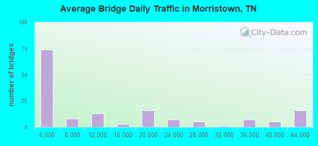
- 2,001,117Total average daily traffic
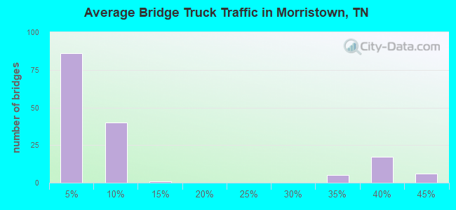
- 461,219Total average daily truck traffic
- National Bridge Inventory (NBI) Registered Bridges for Morristown
- No street view available for this location
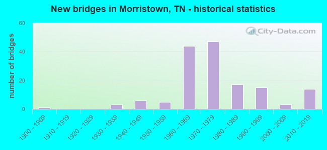
- New bridges - historical statistics
- 11900-1909
- 31930-1939
- 61940-1949
- 51950-1959
- 441960-1969
- 471970-1979
- 171980-1989
- 151990-1999
- 32000-2009
- 142010-2019
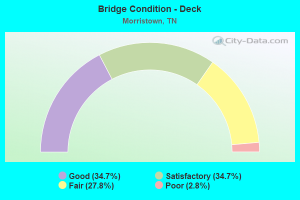
- Bridge Condition - Deck
- 34.7%Good
- 34.7%Satisfactory
- 27.8%Fair
- 2.8%Poor
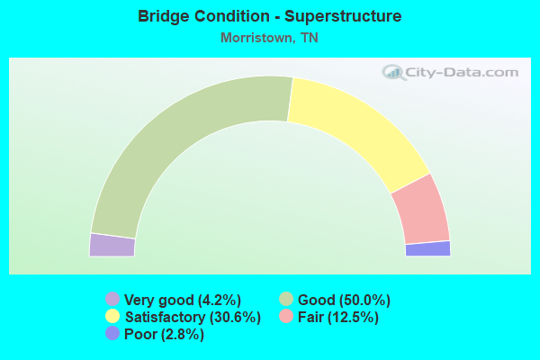
- Bridge Condition - Superstructure
- 4.2%Very good
- 50.0%Good
- 30.6%Satisfactory
- 12.5%Fair
- 2.8%Poor
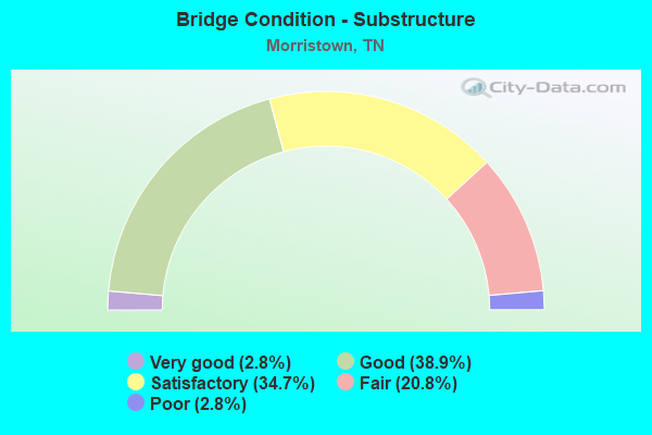
- Bridge Condition - Substructure
- 2.8%Very good
- 38.9%Good
- 34.7%Satisfactory
- 20.8%Fair
- 2.8%Poor
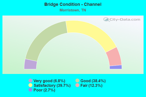
- Bridge Condition - Channel
- 6.8%Very good
- 38.4%Good
- 39.7%Satisfactory
- 12.3%Fair
- 2.7%Poor
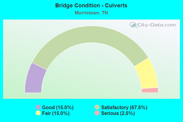
- Bridge Condition - Culverts
- 15.0%Good
- 67.5%Satisfactory
- 15.0%Fair
- 2.5%Serious
Find on map >> Show street view
Structure Number: 32SR0320007, Location: NEAR MORRISTOWN TENN. (Lat: 36.213667, Lng: -83.260417), Route carried "under" structure: US 25, Year Built: 2014, Structure Length: 0. m, Average Daily Traffic: 23,467 (year 2020), Truck Traffic: 9%, Features Intersected: COLLEGE PARK DR, Facility Carried by Structure: COLLEGE PARK DR
Minimum Vertical Clearance: 5.11m (16.77ft), Kilometerpoint: 9.672, Lanes on structure: 3, Lanes under structure: 6, Material/Design: Prestressed concrete continuous, Design/Construction: Stringer/Multi-beam, Length of Maximum Span: 31.1m (102.0ft)
Find on map >> Show street view
Structure Number: 32SR0320009, Location: NEAR MORRISTOWN TENN. (Lat: 36.216683, Lng: -83.257017), Route carried "under" structure: City street 602, Year Built: 2014, Structure Length: 0. m, Average Daily Traffic: 9,830 (year 2022), Truck Traffic: 2%, Features Intersected: SR-32, Facility Carried by Structure: PEDESTRAIN WALKWAY
Minimum Vertical Clearance: 5.38m (17.65ft), Kilometerpoint: 0.620, Lanes on structure: 3, Lanes under structure: 3, Material/Design: Prestressed concrete continuous, Design/Construction: Stringer/Multi-beam, Length of Maximum Span: 34.4m (112.9ft)
Find on map >> Show street view
Structure Number: 32SR032001, Location: NEAR MORRISTOWN TENN. (Lat: 36.216800, Lng: -83.257233), Route carried "under" structure: City street 602, Year Built: 2014, Structure Length: 0. m, Average Daily Traffic: 9,830 (year 2022), Truck Traffic: 2%, Features Intersected: SR-32, Facility Carried by Structure: PEDESTRAIN WALKWAY
Minimum Vertical Clearance: 5.38m (17.65ft), Kilometerpoint: 0.652, Lanes on structure: 3, Lanes under structure: 3, Material/Design: Prestressed concrete continuous, Design/Construction: Stringer/Multi-beam, Length of Maximum Span: 34.4m (112.9ft)
Find on map >> Show street view
Structure Number: 32SR0324001, Location: SE MORRISTOWN (Lat: 36.196617, Lng: -83.265167), Route carried "under" structure: City street 1322, Year Built: 1975, Structure Length: 0. m, Average Daily Traffic: 1,817 (year 2020), Truck Traffic: 3%, Features Intersected: SR 32 (OLD SR 32 BYPASS), Facility Carried by Structure: FAP 32
Minimum Vertical Clearance: 5.69m (18.67ft), Kilometerpoint: 5.182, Lanes on structure: 2, Lanes under structure: 2, Material/Design: Prestressed concrete continuous, Design/Construction: Stringer/Multi-beam, Length of Maximum Span: 17.4m (57.1ft)
Find on map >> Show street view
Structure Number: 32SR0324002, Location: SE. MORRISTOWN (Lat: 36.196567, Lng: -83.265500), Route carried "under" structure: City street 1322, Year Built: 1975, Structure Length: 0. m, Average Daily Traffic: 1,817 (year 2020), Truck Traffic: 3%, Features Intersected: SR 32 (OLD SR 32 BYPASS), Facility Carried by Structure: FAP 32
Minimum Vertical Clearance: 5.64m (18.50ft), Kilometerpoint: 5.198, Lanes on structure: 2, Lanes under structure: 2, Material/Design: Prestressed concrete continuous, Design/Construction: Stringer/Multi-beam, Length of Maximum Span: 17.4m (57.1ft)
Find on map >> Show street view
Structure Number: 32SR0324003, Location: IN MORRISTOWN (Lat: 36.226317, Lng: -83.258283), Route carried "under" structure: State highway 34, Year Built: 1975, Structure Length: 0. m, Average Daily Traffic: 12,711 (year 2020), Truck Traffic: 9%, Features Intersected: SR 32, Facility Carried by Structure: FAP 32
Minimum Vertical Clearance: 6.58m (21.59ft), Kilometerpoint: 17.928, Lanes on structure: 3, Lanes under structure: 5, Material/Design: Prestressed concrete continuous, Design/Construction: Stringer/Multi-beam, Length of Maximum Span: 22.8m (74.8ft)
Find on map >> Show street view
Structure Number: 32SR0324004, Location: IN MORRISTOWN (Lat: 36.226033, Lng: -83.258533), Route carried "under" structure: State highway 3836, Year Built: 1975, Structure Length: 0. m, Average Daily Traffic: 17,808 (year 2020), Truck Traffic: 4%, Features Intersected: SR 32, Facility Carried by Structure: FAP 32
Minimum Vertical Clearance: 5.06m (16.60ft), Kilometerpoint: 6.083, Lanes on structure: 3, Lanes under structure: 5, Material/Design: Prestressed concrete continuous, Design/Construction: Box Beam or Girders - Single/Spread, Length of Maximum Span: 26.0m (85.3ft)
Find on map >> Show street view
Structure Number: 32SR0324007, Location: NEAR MORRISTOWN TENN. (Lat: 36.256767, Lng: -83.281500), Route carried "under" structure: US 25, Year Built: 1975, Structure Length: 0. m, Average Daily Traffic: 10,449 (year 2020), Truck Traffic: 4%, Features Intersected: SR 32 RL, Facility Carried by Structure: FAP 32
Minimum Vertical Clearance: 5.19m (17.03ft), Kilometerpoint: 12.006, Lanes on structure: 2, Lanes under structure: 1, Material/Design: Concrete continuous, Design/Construction: Box Beam or Girders - Single/Spread, Length of Maximum Span: 27.4m (89.9ft)
Find on map >> Show street view
Structure Number: 32SR0324008, Location: NEAR MORRISTOWN TENN. (Lat: 36.256433, Lng: -83.281583), Route carried "under" structure: US 25, Year Built: 1975, Structure Length: 0. m, Average Daily Traffic: 10,449 (year 2020), Truck Traffic: 4%, Features Intersected: SR 32 LL, Facility Carried by Structure: FAP 32
Minimum Vertical Clearance: 6.63m (21.75ft), Kilometerpoint: 11.990, Lanes on structure: 2, Lanes under structure: 1, Material/Design: Concrete continuous, Design/Construction: Box Beam or Girders - Single/Spread, Length of Maximum Span: 27.4m (89.9ft)
Find on map >> Show street view
Structure Number: 32SR0324009, Location: IN MORRISTOWN (Lat: 36.223300, Lng: -83.258083), Route carried "under" structure: State highway 32, Year Built: 1977, Structure Length: 0. m, Average Daily Traffic: 23,467 (year 2020), Truck Traffic: 9%, Features Intersected: SR 34, Facility Carried by Structure: FAP 34
Minimum Vertical Clearance: 4.98m (16.34ft), Kilometerpoint: 10.944, Lanes on structure: 6, Lanes under structure: 5, Material/Design: Concrete continuous, Design/Construction: Box Beam or Girders - Single/Spread, Length of Maximum Span: 33.5m (109.9ft)
Find on map >> Show street view
Structure Number: 32SR0324011, Location: NEAR MORRISTOWN TENN. (Lat: 36.190933, Lng: -83.268467), Route carried "under" structure: State highway 160, Year Built: 1975, Structure Length: 0. m, Average Daily Traffic: 10,633 (year 2020), Truck Traffic: 4%, Features Intersected: SR-32 / SR-160, Facility Carried by Structure: FAP 32
Minimum Vertical Clearance: 5.08m (16.67ft), Kilometerpoint: 11.684, Lanes on structure: 3, Lanes under structure: 4, Material/Design: Steel continuous, Design/Construction: Stringer/Multi-beam, Length of Maximum Span: 34.4m (112.9ft)
Find on map >> Show street view
Structure Number: 32SR0324012, Location: NEAR MORRISTOWN TENN. (Lat: 36.191250, Lng: -83.268800), Route carried "under" structure: State highway 160, Year Built: 1975, Structure Length: 0. m, Average Daily Traffic: 19,812 (year 2020), Truck Traffic: 9%, Features Intersected: SR 32, Facility Carried by Structure: FAP 32
Minimum Vertical Clearance: 6.58m (21.59ft), Kilometerpoint: 11.716, Lanes on structure: 3, Lanes under structure: 4, Material/Design: Steel continuous, Design/Construction: Stringer/Multi-beam, Length of Maximum Span: 34.4m (112.9ft)
Find on map >> Show street view
Structure Number: 32SR0340003, Location: IN MORRISTOWN (Lat: 36.221800, Lng: -83.278317), Route carried "under" structure: City street 3838, Year Built: 1967, Structure Length: 0. m, Average Daily Traffic: 8,590 (year 2020), Truck Traffic: 4%, Features Intersected: FAU 3836 (OLD SR 34), Facility Carried by Structure: FAU 3836
Minimum Vertical Clearance: 4.70m (15.42ft), Kilometerpoint: 4.892, Lanes on structure: 4, Lanes under structure: 4, Material/Design: Concrete continuous, Design/Construction: Tee Beam, Length of Maximum Span: 20.0m (65.6ft)
Find on map >> Show street view
Structure Number: 32SR0660001, Location: NEAR JCT SR474 (Lat: 36.175317, Lng: -83.346217), Route carried "under" structure: State highway 160, Year Built: 2017, Structure Length: 0. m, Average Daily Traffic: 17,158 (year 2020), Truck Traffic: 9%
Minimum Vertical Clearance: 5.51m (18.08ft), Kilometerpoint: 19.377, Lanes on structure: 4, Lanes under structure: 5, Material/Design: Prestressed concrete continuous, Design/Construction: Stringer/Multi-beam, Length of Maximum Span: 41.1m (134.8ft)
Find on map >> Show street view
Structure Number: 32SR0660003, Location: NEAR JCT SR474 (Lat: 36.177000, Lng: -83.347950), Route carried "under" structure: County highway 2522, Year Built: 2017, Structure Length: 0. m, Average Daily Traffic: 588 (year 2020), Truck Traffic: 4%, Features Intersected: SR 66
Minimum Vertical Clearance: 8.03m (26.35ft), Kilometerpoint: 1.867, Lanes on structure: 4, Lanes under structure: 2, Material/Design: Prestressed concrete continuous, Design/Construction: Stringer/Multi-beam, Length of Maximum Span: 18.6m (61.0ft)
Find on map >> Show street view
Structure Number: 32SR1600011, Location: MORRISTOWN (Lat: 36.165667, Lng: -83.212300), Route carried "under" structure: State highway 160, Year Built: 1960, Structure Length: 0. m, Average Daily Traffic: 3,273 (year 2020), Truck Traffic: 3%, Features Intersected: SOUTHERN RAILWAY, Facility Carried by Structure: SOU RWY 730286K
Minimum Vertical Clearance: 4.30m (14.11ft), Kilometerpoint: 4.925, Lanes under structure: 4, Material/Design: Steel, Design/Construction: Stringer/Multi-beam, Length of Maximum Span: 13.4m (44.0ft)
Find on map >> Show street view
Structure Number: 32SR1600019, Location: .7 M NW OF JCT SR32&SR160 (Lat: 36.193117, Lng: -83.279167), Route carried "under" structure: State highway 343, Year Built: 1992, Structure Length: 0. m, Average Daily Traffic: 12,868 (year 2020), Truck Traffic: 4%, Features Intersected: SR 160, Facility Carried by Structure: FAP 160
Minimum Vertical Clearance: 7.52m (24.67ft), Kilometerpoint: 3.798, Lanes on structure: 3, Lanes under structure: 5, Material/Design: Prestressed concrete continuous, Design/Construction: Box Beam or Girders - Single/Spread, Length of Maximum Span: 29.9m (98.1ft)
Find on map >> Show street view
Structure Number: 32SR160002, Location: .7 M NW OF JCT SR32&SR160 (Lat: 36.192850, Lng: -83.279167), Route carried "under" structure: State highway 343, Year Built: 1992, Structure Length: 0. m, Average Daily Traffic: 9,597 (year 2020), Truck Traffic: 4%, Features Intersected: SR 160, Facility Carried by Structure: FAP 160
Minimum Vertical Clearance: 6.78m (22.24ft), Kilometerpoint: 3.766, Lanes on structure: 3, Lanes under structure: 5, Material/Design: Prestressed concrete continuous, Design/Construction: Box Beam or Girders - Single/Spread, Length of Maximum Span: 28.7m (94.2ft)
Find on map >> Show street view
Structure Number: 45I00810015, Location: 6.4 MI NE JCT I40&I81 (Lat: 36.130333, Lng: -83.307317), Route carried "under" structure: County highway 2518, Year Built: 1966, Structure Length: 0. m, Average Daily Traffic: 670 (year 2020), Truck Traffic: 3%, Features Intersected: I81 RT LN, Facility Carried by Structure: I81 RT LN
Minimum Vertical Clearance: 5.69m (18.67ft), Kilometerpoint: 1.352, Lanes on structure: 2, Lanes under structure: 2, Material/Design: Steel, Design/Construction: Stringer/Multi-beam, Length of Maximum Span: 28.0m (91.9ft)
Find on map >> Show street view
Structure Number: 45I00810016, Location: 6.4 MI NE JCT I40&I81 (Lat: 36.130667, Lng: -83.307683), Route carried "under" structure: County highway 2518, Year Built: 1966, Structure Length: 0. m, Average Daily Traffic: 670 (year 2020), Truck Traffic: 3%, Features Intersected: I81 LF LN, Facility Carried by Structure: I81 LF LN
Minimum Vertical Clearance: 5.34m (17.52ft), Kilometerpoint: 1.400, Lanes on structure: 2, Lanes under structure: 2, Material/Design: Steel, Design/Construction: Stringer/Multi-beam, Length of Maximum Span: 28.0m (91.9ft)