Bridge Statistics for Mount Airy, North Carolina (NC)
Condition, Traffic, Stress, Structural Evaluation, Project Costs
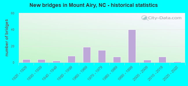
- New bridges - historical statistics
- 41920-1929
- 41930-1939
- 21940-1949
- 81950-1959
- 191960-1969
- 151970-1979
- 71980-1989
- 401990-1999
- 32000-2009
- 72010-2019
- 12020-2022
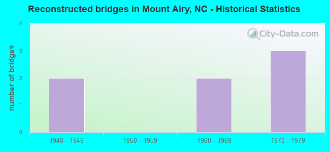
- Reconstructed bridges - Historical Statistics
- 21940-1949
- 01950-1959
- 21960-1969
- 31970-1979
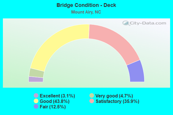
- Bridge Condition - Deck
- 3.1%Excellent
- 4.7%Very good
- 43.8%Good
- 35.9%Satisfactory
- 12.5%Fair
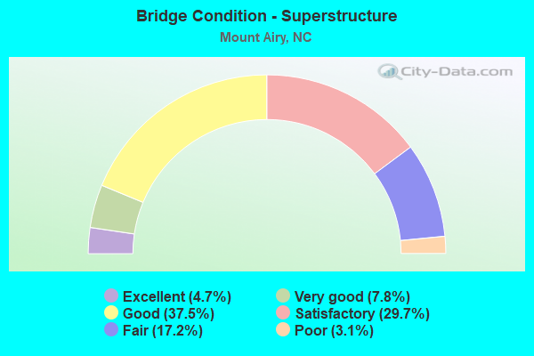
- Bridge Condition - Superstructure
- 4.7%Excellent
- 7.8%Very good
- 37.5%Good
- 29.7%Satisfactory
- 17.2%Fair
- 3.1%Poor
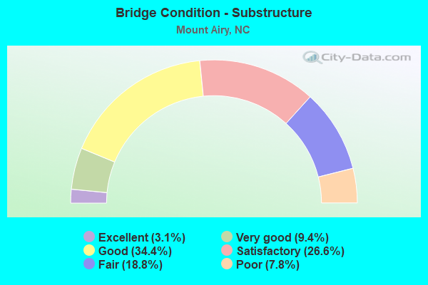
- Bridge Condition - Substructure
- 3.1%Excellent
- 9.4%Very good
- 34.4%Good
- 26.6%Satisfactory
- 18.8%Fair
- 7.8%Poor
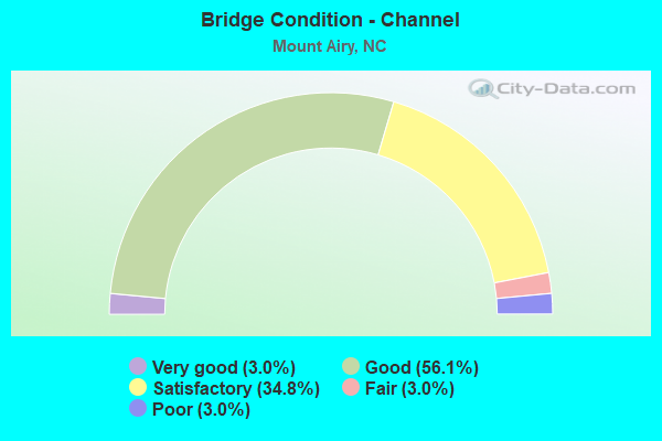
- Bridge Condition - Channel
- 3.0%Very good
- 56.1%Good
- 34.8%Satisfactory
- 3.0%Fair
- 3.0%Poor
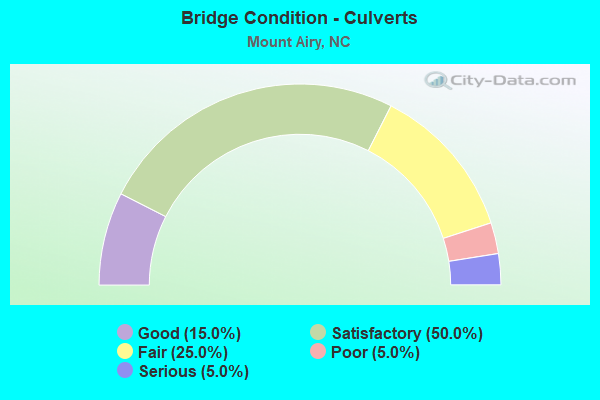
- Bridge Condition - Culverts
- 15.0%Good
- 50.0%Satisfactory
- 25.0%Fair
- 5.0%Poor
- 5.0%Serious
Find on map >> Show street view
Structure Number: 1710193, Location: .3 MI.S.JCT.US601 (Lat: 36.482258, Lng: -80.607658), Route carried "on" structure: Bypass US 52, Year Built: 1969, Status: Open, Structure Length: 8.01m (26.28ft), Average Daily Traffic: 8,000 (year 2015), Truck Traffic: 12%, Average Future Daily Traffic: 16,000 (year 2040), Design Load: HS 20+Mod, Features Intersected: LOVILLS CREEK
Minimum Vertical Clearance: 30+ m (98+ ft), Kilometerpoint: 43.891, Lanes on structure: 2, Base Highway Network: Yes (Inventory Route: 2, Subroute: 52), Owner: State Highway Agency, Approaching Roadway Width: 8.5m (27.9ft), Skew: 14 degrees, Material/Design: Steel, Design/Construction: Stringer/Multi-beam, Number Of Spans In Main Unit: 5, Length of Maximum Span: 18.2m (59.7ft), Curb-To-Curb Width: 12.1m (39.7ft), Out-to-Out Width: 12.8m (42.0ft)
Condition: Deck: Satisfactory, Superstructure: Fair, Substructure: Satisfactory, Channel: Good, Operating Rating: 56.2 metric tons, Method Used To Determine Operating Rating: Load Factor (LF), Inventory Rating: 33.5 metric tons, Method Used To Determine Inventory Rating: Load Factor (LF), Structural Evaluation: Somewhat better than minimum adequacy, Deck Geometry: Better than present minimum criteria, Waterway Adequacy: Better than present minimum criteria, Approach Roadway Alignment: Equal to present desirable criteria, Designated Inspection Frequency: Every 24 months, Inspection Date: September 2021, Deck Structure Type: Concrete Cast-file-Place, Wearing Surface/Protective System: Wearing Surface: Bituminous
Find on map >> Show street view
Structure Number: 1710199, Location: .1 MI.W.JCT.SR1670 (Lat: 36.499406, Lng: -80.622167), Route carried "on" structure: Bypass US 52, Year Built: 1969, Status: Open, Structure Length: 4.84m (15.88ft), Average Daily Traffic: 11,500 (year 2019), Truck Traffic: 12%, Average Future Daily Traffic: 23,000 (year 2040), Design Load: HS 20+Mod, Features Intersected: NC89
Minimum Vertical Clearance: 30+ m (98+ ft), Kilometerpoint: 0.000, Lanes on structure: 3, Lanes under structure: 5, Base Highway Network: Yes (Inventory Route: 2, Subroute: 52), Owner: State Highway Agency, Approaching Roadway Width: 11.8m (38.7ft), Skew: 11 degrees, Material/Design: Steel continuous, Design/Construction: Stringer/Multi-beam, Number Of Spans In Main Unit: 3, Length of Maximum Span: 26.2m (86.0ft), Curb-To-Curb Width: 14.6m (47.9ft), Out-to-Out Width: 15.2m (49.9ft)
Condition: Deck: Satisfactory, Superstructure: Good, Substructure: Good, Operating Rating: 69.8 metric tons, Method Used To Determine Operating Rating: Load Factor (LF), Inventory Rating: 41.7 metric tons, Method Used To Determine Inventory Rating: Load Factor (LF), Structural Evaluation: Better than present minimum criteria, Deck Geometry: Somewhat better than minimum adequacy, Underclear: High priority of corrective action, Approach Roadway Alignment: Equal to present desirable criteria, Designated Inspection Frequency: Every 24 months, Inspection Date: September 2021, Deck Structure Type: Concrete Cast-file-Place, Wearing Surface/Protective System: Wearing Surface: Bituminous
Find on map >> Show street view
Structure Number: 1710201, Location: 1 MI.N.JCT.SR1407 (Lat: 36.496439, Lng: -80.843408), Route carried "on" structure: State highway 1338, Year Built: 1985, Status: Posted for load, Structure Length: 3.07m (10.07ft), Average Daily Traffic: 530 (year 2016), Truck Traffic: 6%, Average Future Daily Traffic: 1,060 (year 2040), Features Intersected: FISHER RIVER
Minimum Vertical Clearance: 30+ m (98+ ft), Kilometerpoint: 0.000, Lanes on structure: 2, Owner: State Highway Agency, Approaching Roadway Width: 5.4m (17.7ft), Material/Design: Steel, Design/Construction: Stringer/Multi-beam, Number Of Spans In Main Unit: 2, Length of Maximum Span: 15.2m (49.9ft), Curb-To-Curb Width: 7.3m (24.0ft), Out-to-Out Width: 7.6m (24.9ft)
Condition: Deck: Good, Superstructure: Satisfactory, Substructure: Satisfactory, Channel: Satisfactory, Operating Rating: 35.3 metric tons, Method Used To Determine Operating Rating: Load Factor (LF), Inventory Rating: 20.8 metric tons, Method Used To Determine Inventory Rating: Load Factor (LF), Structural Evaluation: Somewhat better than minimum adequacy, Deck Geometry: Meets minimum limits, Waterway Adequacy: Better than present minimum criteria, Approach Roadway Alignment: Equal to present desirable criteria, Bridge Posting: Required (Relationship of Operating Rating to Maximum Legal Load: 10.0 - 19.9% below), Designated Inspection Frequency: Every 24 months, Inspection Date: September 2021, Deck Structure Type: Corrugated Steel, Wearing Surface/Protective System: Wearing Surface: Bituminous
Find on map >> Show street view
Structure Number: 1710205, Location: 0.1 MI.W.JCT.SR1670 (Lat: 36.499439, Lng: -80.622389), Route carried "on" structure: Bypass US 52, Year Built: 1969, Status: Open, Structure Length: 5.15m (16.90ft), Average Daily Traffic: 11,500 (year 2019), Truck Traffic: 12%, Average Future Daily Traffic: 23,000 (year 2040), Design Load: HS 20+Mod, Features Intersected: NC89
Minimum Vertical Clearance: 30+ m (98+ ft), Kilometerpoint: 0.000, Lanes on structure: 2, Lanes under structure: 5, Base Highway Network: Yes (Inventory Route: 2, Subroute: 52), Owner: State Highway Agency, Approaching Roadway Width: 8.5m (27.9ft), Skew: 11 degrees, Material/Design: Steel continuous, Design/Construction: Stringer/Multi-beam, Number Of Spans In Main Unit: 3, Length of Maximum Span: 29.2m (95.8ft), Curb-To-Curb Width: 12.1m (39.7ft), Out-to-Out Width: 12.8m (42.0ft)
Condition: Deck: Good, Superstructure: Good, Substructure: Good, Operating Rating: 66.2 metric tons, Method Used To Determine Operating Rating: Load Factor (LF), Inventory Rating: 39.9 metric tons, Method Used To Determine Inventory Rating: Load Factor (LF), Structural Evaluation: Better than present minimum criteria, Deck Geometry: Better than present minimum criteria, Underclear: Somewhat better than minimum adequacy, Approach Roadway Alignment: Equal to present desirable criteria, Designated Inspection Frequency: Every 24 months, Inspection Date: September 2021, Deck Structure Type: Concrete Cast-file-Place, Wearing Surface/Protective System: Wearing Surface: Bituminous
Find on map >> Show street view
Structure Number: 1710221, Location: .1 MI.W.JCT.SR1626 (Lat: 36.538239, Lng: -80.663875), Route carried "on" structure: State highway 1625, Year Built: 2009, Status: Open, Structure Length: 3.50m (11.48ft), Average Daily Traffic: 1,500 (year 2019), Truck Traffic: 6%, Average Future Daily Traffic: 3,000 (year 2040), Design Load: HS 25 or greater, Features Intersected: PAULS CREEK
Minimum Vertical Clearance: 30+ m (98+ ft), Kilometerpoint: 0.000, Lanes on structure: 2, Owner: State Highway Agency, Approaching Roadway Width: 6.4m (21.0ft), Material/Design: Prestressed concrete, Design/Construction: Box Beam or Girders - Multiple, Number Of Spans In Main Unit: 2, Length of Maximum Span: 24.0m (78.7ft), Curb-To-Curb Width: 9.1m (29.9ft), Out-to-Out Width: 10.0m (32.8ft)
Condition: Deck: Good, Superstructure: Good, Substructure: Good, Channel: Good, Operating Rating: 89.8 metric tons, Method Used To Determine Operating Rating: Load Factor (LF), Inventory Rating: 65.3 metric tons, Method Used To Determine Inventory Rating: Load Factor (LF), Structural Evaluation: Better than present minimum criteria, Deck Geometry: Somewhat better than minimum adequacy, Waterway Adequacy: Better than present minimum criteria, Approach Roadway Alignment: Equal to present desirable criteria, Designated Inspection Frequency: Every 24 months, Inspection Date: September 2021, Deck Structure Type: Concrete Precast Panels, Wearing Surface/Protective System: Wearing Surface: Bituminous
Find on map >> Show street view
Structure Number: 1710227, Location: 0.1 MI.W.JCT.SR1633 (Lat: 36.499900, Lng: -80.627778), Route carried "on" structure: State highway 1389, Year Built: 1956, Status: Open, Structure Length: 0.76m (2.49ft), Average Daily Traffic: 550 (year 2019), Truck Traffic: 7%, Average Future Daily Traffic: 1,100 (year 2040), Features Intersected: UT TO LOVILLS CREEK
Minimum Vertical Clearance: 30+ m (98+ ft), Kilometerpoint: 0.000, Lanes on structure: 2, Owner: State Highway Agency, Approaching Roadway Width: 5.4m (17.7ft), Material/Design: Steel, Design/Construction: Stringer/Multi-beam, Number Of Spans In Main Unit: 1, Length of Maximum Span: 6.7m (22.0ft), Curb-To-Curb Width: 5.7m (18.7ft), Out-to-Out Width: 6.0m (19.7ft)
Condition: Deck: Good, Superstructure: Good, Substructure: Good, Channel: Good, Operating Rating: 67.1 metric tons, Method Used To Determine Operating Rating: Load Factor (LF), Inventory Rating: 39.9 metric tons, Method Used To Determine Inventory Rating: Load Factor (LF), Structural Evaluation: Better than present minimum criteria, Deck Geometry: High priority of replacement, Waterway Adequacy: Better than present minimum criteria, Approach Roadway Alignment: Equal to present desirable criteria, Designated Inspection Frequency: Every 24 months, Inspection Date: September 2021, Deck Structure Type: Wood or Timber, Wearing Surface/Protective System: Wearing Surface: Bituminous
Find on map >> Show street view
Structure Number: 1710231, Location: 0.9 MI.E.JCT.SR1624 (Lat: 36.539867, Lng: -80.661514), Route carried "on" structure: State highway 1625, Year Built: 1992, Status: Open, Structure Length: 1.43m (4.69ft), Average Daily Traffic: 1,500 (year 2019), Truck Traffic: 7%, Average Future Daily Traffic: 3,000 (year 2040), Design Load: HS 20+Mod, Features Intersected: BRUSHY FORK CREEK
Minimum Vertical Clearance: 30+ m (98+ ft), Kilometerpoint: 0.000, Lanes on structure: 2, Owner: State Highway Agency, Approaching Roadway Width: 5.4m (17.7ft), Skew: 3 degrees, Material/Design: Prestressed concrete, Design/Construction: Slab, Number Of Spans In Main Unit: 1, Length of Maximum Span: 13.4m (44.0ft), Curb-To-Curb Width: 8.2m (26.9ft), Out-to-Out Width: 9.1m (29.9ft)
Condition: Deck: Good, Superstructure: Good, Substructure: Good, Channel: Good, Operating Rating: 89.8 metric tons, Method Used To Determine Operating Rating: Load Factor (LF), Inventory Rating: 58.0 metric tons, Method Used To Determine Inventory Rating: Load Factor (LF), Structural Evaluation: Better than present minimum criteria, Deck Geometry: Meets minimum limits, Waterway Adequacy: Better than present minimum criteria, Approach Roadway Alignment: Equal to present desirable criteria, Designated Inspection Frequency: Every 24 months, Inspection Date: September 2021, Deck Structure Type: Concrete Precast Panels, Wearing Surface/Protective System: Wearing Surface: Bituminous
Find on map >> Show street view
Structure Number: 171026, Location: .2 MI.W.JCT.SR1701 (Lat: 36.542522, Lng: -80.625819), Route carried "on" structure: State highway 1700, Year Built: 1992, Status: Open, Structure Length: 4.14m (13.58ft), Average Daily Traffic: 2,000 (year 2014), Truck Traffic: 7%, Average Future Daily Traffic: 4,000 (year 2040), Design Load: HS 20+Mod, Features Intersected: LOVILLS CREEK
Minimum Vertical Clearance: 30+ m (98+ ft), Kilometerpoint: 0.000, Lanes on structure: 2, Owner: State Highway Agency, Approaching Roadway Width: 6.4m (21.0ft), Material/Design: Prestressed concrete, Design/Construction: Slab, Number Of Spans In Main Unit: 3, Length of Maximum Span: 13.4m (44.0ft), Curb-To-Curb Width: 9.1m (29.9ft), Out-to-Out Width: 10.0m (32.8ft)
Condition: Deck: Good, Superstructure: Good, Substructure: Good, Channel: Good, Operating Rating: 89.8 metric tons, Method Used To Determine Operating Rating: Load Factor (LF), Inventory Rating: 57.1 metric tons, Method Used To Determine Inventory Rating: Load Factor (LF), Structural Evaluation: Better than present minimum criteria, Deck Geometry: Somewhat better than minimum adequacy, Waterway Adequacy: Better than present minimum criteria, Approach Roadway Alignment: Equal to present desirable criteria, Designated Inspection Frequency: Every 24 months, Inspection Date: August 2021, Deck Structure Type: Concrete Precast Panels, Wearing Surface/Protective System: Wearing Surface: Bituminous
Find on map >> Show street view
Structure Number: 1710269, Location: .3 MI.W.JCT.US52 (Lat: 36.550075, Lng: -80.657397), Route carried "on" structure: State highway 1627, Year Built: 1980, Status: Open, Structure Length: 0.64m (2.10ft), Average Daily Traffic: 2,200 (year 2016), Truck Traffic: 7%, Average Future Daily Traffic: 44,000 (year 2040), Design Load: HS 20, Features Intersected: BRUSHY FORK CREEK
Minimum Vertical Clearance: 30+ m (98+ ft), Kilometerpoint: 0.000, Lanes on structure: 2, Owner: State Highway Agency, Approaching Roadway Width: 5.7m (18.7ft), Material/Design: Steel, Design/Construction: Culvert, Number Of Spans In Main Unit: 2, Length of Maximum Span: 2.7m (8.9ft)
Condition: Channel: Good, Culverts: Fair, Operating Rating: 89.8 metric tons, Method Used To Determine Operating Rating: Load and Resistance Factor (LRFR), Inventory Rating: 89.8 metric tons, Method Used To Determine Inventory Rating: Load and Resistance Factor (LRFR), Structural Evaluation: Somewhat better than minimum adequacy, Waterway Adequacy: Better than present minimum criteria, Approach Roadway Alignment: Equal to present desirable criteria, Designated Inspection Frequency: Every 24 months, Underwater Inspection Frequency: Every 60 months, Inspection Date: September 2021, Underwater Inspection Date: September 2019
Find on map >> Show street view
Structure Number: 1710271, Location: .4 MI.E.JCT.SR1739 (Lat: 36.517339, Lng: -80.583481), Route carried "on" structure: State highway 1740, Year Built: 1991, Status: Open, Structure Length: 0.70m (2.30ft), Average Daily Traffic: 240 (year 2014), Truck Traffic: 7%, Average Future Daily Traffic: 480 (year 2040), Design Load: HS 20+Mod, Features Intersected: CHAMP CREEK
Minimum Vertical Clearance: 30+ m (98+ ft), Kilometerpoint: 0.000, Lanes on structure: 2, Owner: State Highway Agency, Approaching Roadway Width: 5.1m (16.7ft), Material/Design: Steel, Design/Construction: Culvert, Number Of Spans In Main Unit: 2, Length of Maximum Span: 3.0m (9.8ft)
Condition: Channel: Good, Culverts: Satisfactory, Operating Rating: 89.8 metric tons, Method Used To Determine Operating Rating: Load and Resistance Factor (LRFR), Inventory Rating: 89.8 metric tons, Method Used To Determine Inventory Rating: Load and Resistance Factor (LRFR), Structural Evaluation: Equal to present minimum criteria, Waterway Adequacy: Better than present minimum criteria, Approach Roadway Alignment: Equal to present desirable criteria, Designated Inspection Frequency: Every 24 months, Underwater Inspection Frequency: Every 60 months, Inspection Date: August 2021, Underwater Inspection Date: September 2017
Find on map >> Show street view
Structure Number: 1710289, Location: .2 MI.N.JCT.NC89 (Lat: 36.505625, Lng: -80.693242), Route carried "on" structure: State highway 1620, Year Built: 1969, Status: Posted for load, Structure Length: 0.94m (3.08ft), Average Daily Traffic: 350 (year 2016), Truck Traffic: 6%, Average Future Daily Traffic: 750 (year 2040), Design Load: H 15, Features Intersected: MOORES FORK CREEK
Minimum Vertical Clearance: 30+ m (98+ ft), Kilometerpoint: 0.000, Lanes on structure: 2, Owner: State Highway Agency, Approaching Roadway Width: 5.7m (18.7ft), Material/Design: Prestressed concrete, Design/Construction: Channel Beam, Number Of Spans In Main Unit: 1, Length of Maximum Span: 9.1m (29.9ft), Curb-To-Curb Width: 7.4m (24.3ft), Out-to-Out Width: 7.6m (24.9ft)
Condition: Deck: Good, Superstructure: Satisfactory, Substructure: Poor, Channel: Fair, Operating Rating: 46.2 metric tons, Method Used To Determine Operating Rating: Load Factor (LF), Inventory Rating: 24.4 metric tons, Method Used To Determine Inventory Rating: Allowable Stress (AS), Structural Evaluation: Meets minimum limits, Deck Geometry: Somewhat better than minimum adequacy, Waterway Adequacy: Better than present minimum criteria, Approach Roadway Alignment: Equal to present desirable criteria, Bridge Posting: Required (Relationship of Operating Rating to Maximum Legal Load: 0.1 - 9.9% below), Designated Inspection Frequency: Every 24 months, Underwater Inspection Frequency: Every 60 months, Inspection Date: September 2021, Underwater Inspection Date: October 2021, Deck Structure Type: Concrete Precast Panels, Wearing Surface/Protective System: Wearing Surface: Bituminous
Find on map >> Show street view
Structure Number: 1710291, Location: .4 MI.S.JCT.SR1826 (Lat: 36.422908, Lng: -80.527506), Route carried "on" structure: State highway 2012, Year Built: 1923, Status: Open, Structure Length: 1.28m (4.20ft), Average Daily Traffic: 1,600 (year 2018), Truck Traffic: 6%, Average Future Daily Traffic: 3,200 (year 2040), Design Load: H 15, Features Intersected: FLAT SHOAL CREEK
Minimum Vertical Clearance: 30+ m (98+ ft), Kilometerpoint: 0.000, Lanes on structure: 2, Owner: State Highway Agency, Approaching Roadway Width: 6.0m (19.7ft), Material/Design: Concrete, Design/Construction: Tee Beam, Number Of Spans In Main Unit: 1, Length of Maximum Span: 12.4m (40.7ft), Curb or Sidewalk Widths: Left: 0.1m (0.3ft), Right: 0.1m (0.3ft), Curb-To-Curb Width: 6.0m (19.7ft), Out-to-Out Width: 7.0m (23.0ft)
Condition: Deck: Fair, Superstructure: Fair, Substructure: Fair, Channel: Good, Operating Rating: 41.7 metric tons, Method Used To Determine Operating Rating: Load Factor (LF), Inventory Rating: 24.4 metric tons, Method Used To Determine Inventory Rating: Load Factor (LF), Structural Evaluation: Somewhat better than minimum adequacy, Deck Geometry: High priority of replacement, Waterway Adequacy: Better than present minimum criteria, Approach Roadway Alignment: Equal to present desirable criteria, Designated Inspection Frequency: Every 24 months, Inspection Date: August 2021, Deck Structure Type: Concrete Cast-file-Place, Wearing Surface/Protective System: Wearing Surface: Bituminous
Find on map >> Show street view
Structure Number: 1710292, Location: .3 MI.N.JCT.SR2015 (Lat: 36.446339, Lng: -80.555739), Route carried "on" structure: State highway 2012, Year Built: 1923, Status: Open, Structure Length: 1.12m (3.67ft), Average Daily Traffic: 2,700 (year 2018), Truck Traffic: 6%, Average Future Daily Traffic: 5,400 (year 2040), Design Load: H 15, Features Intersected: STONEY CREEK
Minimum Vertical Clearance: 30+ m (98+ ft), Kilometerpoint: 0.000, Lanes on structure: 2, Owner: State Highway Agency, Approaching Roadway Width: 6.0m (19.7ft), Material/Design: Concrete, Design/Construction: Tee Beam, Number Of Spans In Main Unit: 1, Length of Maximum Span: 10.9m (35.8ft), Curb or Sidewalk Widths: Left: 0.1m (0.3ft), Right: 0.1m (0.3ft), Curb-To-Curb Width: 6.1m (20.0ft), Out-to-Out Width: 7.0m (23.0ft)
Condition: Deck: Fair, Superstructure: Fair, Substructure: Fair, Channel: Good, Operating Rating: 70.7 metric tons, Method Used To Determine Operating Rating: Load Factor (LF), Inventory Rating: 42.6 metric tons, Method Used To Determine Inventory Rating: Load Factor (LF), Structural Evaluation: Somewhat better than minimum adequacy, Deck Geometry: High priority of replacement, Waterway Adequacy: Better than present minimum criteria, Approach Roadway Alignment: Equal to present desirable criteria, Designated Inspection Frequency: Every 24 months, Inspection Date: August 2021, Deck Structure Type: Concrete Cast-file-Place, Wearing Surface/Protective System: Wearing Surface: Bituminous
Find on map >> Show street view
Structure Number: 17103, Location: .6 MI.W.JCT.SR2027 (Lat: 36.416789, Lng: -80.579697), Route carried "on" structure: State highway 2026, Year Built: 1976, Status: Posted for load, Structure Length: 0.94m (3.08ft), Average Daily Traffic: 270 (year 2016), Truck Traffic: 6%, Average Future Daily Traffic: 540 (year 2040), Features Intersected: OLDFIELD CREEK
Minimum Vertical Clearance: 30+ m (98+ ft), Kilometerpoint: 0.000, Lanes on structure: 2, Owner: State Highway Agency, Approaching Roadway Width: 5.4m (17.7ft), Material/Design: Steel, Design/Construction: Stringer/Multi-beam, Number Of Spans In Main Unit: 1, Length of Maximum Span: 9.1m (29.9ft), Curb-To-Curb Width: 7.2m (23.6ft), Out-to-Out Width: 7.3m (24.0ft)
Condition: Deck: Satisfactory, Superstructure: Satisfactory, Substructure: Fair, Channel: Good, Operating Rating: 41.7 metric tons, Method Used To Determine Operating Rating: Load Factor (LF), Inventory Rating: 25.4 metric tons, Method Used To Determine Inventory Rating: Load Factor (LF), Structural Evaluation: Somewhat better than minimum adequacy, Deck Geometry: Meets minimum limits, Waterway Adequacy: Better than present minimum criteria, Approach Roadway Alignment: Equal to present desirable criteria, Bridge Posting: Required (Relationship of Operating Rating to Maximum Legal Load: 0.1 - 9.9% below), Designated Inspection Frequency: Every 24 months, Inspection Date: August 2021, Deck Structure Type: Corrugated Steel, Wearing Surface/Protective System: Wearing Surface: Bituminous
Find on map >> Show street view
Structure Number: 1710301, Location: .2 MI.N.JCT.SR1822 (Lat: 36.444961, Lng: -80.493728), Route carried "on" structure: State highway 1825, Year Built: 1995, Status: Open, Structure Length: 0.67m (2.20ft), Average Daily Traffic: 250 (year 2019), Average Future Daily Traffic: 500 (year 2040), Design Load: HS 20+Mod, Features Intersected: BRYANTS FORK CREEK
Minimum Vertical Clearance: 30+ m (98+ ft), Kilometerpoint: 0.000, Lanes on structure: 2, Owner: State Highway Agency, Approaching Roadway Width: 5.4m (17.7ft), Skew: 1 degrees, Material/Design: Steel, Design/Construction: Culvert, Number Of Spans In Main Unit: 2, Length of Maximum Span: 2.7m (8.9ft)
Condition: Channel: Good, Culverts: Satisfactory, Operating Rating: 89.8 metric tons, Method Used To Determine Operating Rating: Load and Resistance Factor (LRFR), Inventory Rating: 89.8 metric tons, Method Used To Determine Inventory Rating: Load and Resistance Factor (LRFR), Structural Evaluation: Equal to present minimum criteria, Waterway Adequacy: Better than present minimum criteria, Approach Roadway Alignment: Equal to present desirable criteria, Designated Inspection Frequency: Every 24 months, Underwater Inspection Frequency: Every 60 months, Inspection Date: August 2021, Underwater Inspection Date: September 2017
Find on map >> Show street view
Structure Number: 1710304, Location: .1 MI.E.JCT.SR1871 (Lat: 36.501483, Lng: -80.617361), Route carried "on" structure: State highway 89, Year Built: 1977, Status: Open, Structure Length: 5.48m (17.98ft), Average Daily Traffic: 12,000 (year 2017), Truck Traffic: 6%, Average Future Daily Traffic: 24,000 (year 2040), Design Load: HS 20+Mod, Features Intersected: LOVILLS CREEK
Minimum Vertical Clearance: 30+ m (98+ ft), Kilometerpoint: 0.000, Lanes on structure: 4, Owner: State Highway Agency, Approaching Roadway Width: 15.8m (51.8ft), Skew: 3 degrees, Material/Design: Steel, Design/Construction: Stringer/Multi-beam, Number Of Spans In Main Unit: 4, Length of Maximum Span: 13.4m (44.0ft), Curb or Sidewalk Widths: Left: 1.5m (4.9ft), Right: 1.5m (4.9ft), Curb-To-Curb Width: 15.8m (51.8ft), Out-to-Out Width: 19.5m (64.0ft)
Condition: Deck: Satisfactory, Superstructure: Good, Substructure: Satisfactory, Channel: Good, Operating Rating: 89.8 metric tons, Method Used To Determine Operating Rating: Load Factor (LF), Inventory Rating: 57.1 metric tons, Method Used To Determine Inventory Rating: Load Factor (LF), Structural Evaluation: Equal to present minimum criteria, Deck Geometry: Meets minimum limits, Waterway Adequacy: Better than present minimum criteria, Approach Roadway Alignment: Equal to present desirable criteria, Designated Inspection Frequency: Every 24 months, Inspection Date: September 2021, Deck Structure Type: Concrete Cast-file-Place, Wearing Surface/Protective System: Wearing Surface: Monolithic Concrete
Find on map >> Show street view
Structure Number: 171031, Location: 150' N. JCT. SR1818 (Lat: 36.455700, Lng: -80.541344), Route carried "on" structure: State highway 1774, Year Built: 2019, Status: Open, Structure Length: 2.19m (7.19ft), Average Daily Traffic: 2,100 (year 2016), Truck Traffic: 7%, Average Future Daily Traffic: 4,200 (year 2040), Design Load: HL 93, Features Intersected: STONEY CREEK
Minimum Vertical Clearance: 30+ m (98+ ft), Kilometerpoint: 0.000, Lanes on structure: 2, Owner: State Highway Agency, Approaching Roadway Width: 6.0m (19.7ft), Skew: 1 degrees, Material/Design: Prestressed concrete, Design/Construction: Slab, Number Of Spans In Main Unit: 1, Length of Maximum Span: 21.0m (68.9ft), Curb-To-Curb Width: 9.2m (30.2ft), Out-to-Out Width: 10.0m (32.8ft)
Condition: Deck: Excellent, Superstructure: Excellent, Substructure: Excellent, Channel: Very good, Operating Rating: 57.1 metric tons, Method Used To Determine Operating Rating: Load and Resistance Factor (LRFR), Inventory Rating: 42.6 metric tons, Method Used To Determine Inventory Rating: Load and Resistance Factor (LRFR), Structural Evaluation: Superior to present desirable criteria, Deck Geometry: Meets minimum limits, Waterway Adequacy: Better than present minimum criteria, Approach Roadway Alignment: Equal to present desirable criteria, Designated Inspection Frequency: Every 24 months, Inspection Date: August 2021, Deck Structure Type: Concrete Precast Panels, Wearing Surface/Protective System: Wearing Surface: Bituminous
Find on map >> Show street view
Structure Number: 1710324, Location: .2 MI.S.JCT.SR1359 (Lat: 36.465717, Lng: -80.658803), Route carried "on" structure: State highway 1429, Year Built: 2019, Status: Open, Structure Length: 1.06m (3.48ft), Average Daily Traffic: 80 (year 2000), Average Future Daily Traffic: 160 (year 2040), Features Intersected: BEECH CREEK
Minimum Vertical Clearance: 30+ m (98+ ft), Kilometerpoint: 0.000, Lanes on structure: 2, Owner: State Highway Agency, Approaching Roadway Width: 4.8m (15.7ft), Material/Design: Steel, Design/Construction: Stringer/Multi-beam, Number Of Spans In Main Unit: 1, Length of Maximum Span: 10.6m (34.8ft), Curb-To-Curb Width: 7.3m (24.0ft), Out-to-Out Width: 7.6m (24.9ft)
Condition: Deck: Excellent, Superstructure: Excellent, Substructure: Excellent, Channel: Good, Operating Rating: 77.1 metric tons, Method Used To Determine Operating Rating: Load Factor (LF), Inventory Rating: 46.2 metric tons, Method Used To Determine Inventory Rating: Load Factor (LF), Structural Evaluation: Superior to present desirable criteria, Deck Geometry: Equal to present minimum criteria, Waterway Adequacy: Better than present minimum criteria, Approach Roadway Alignment: Equal to present desirable criteria, Designated Inspection Frequency: Every 24 months, Inspection Date: October 2021, Deck Structure Type: Wood or Timber, Wearing Surface/Protective System: Wearing Surface: Bituminous
Find on map >> Show street view
Structure Number: 171033, Location: .3 MI.N.JCT.US601 (Lat: 36.410211, Lng: -80.690522), Route carried "on" structure: State highway 2258, Year Built: 1920, Year Reconstructed: 1948, Status: Open, Structure Length: 3.87m (12.70ft), Average Daily Traffic: 1,300 (year 2019), Truck Traffic: 6%, Average Future Daily Traffic: 2,600 (year 2040), Design Load: H 15, Features Intersected: FISHER RIVER
Minimum Vertical Clearance: 30+ m (98+ ft), Kilometerpoint: 0.000, Lanes on structure: 2, Owner: State Highway Agency, Approaching Roadway Width: 7.3m (24.0ft), Material/Design: Concrete, Design/Construction: Tee Beam, Number Of Spans In Main Unit: 3, Length of Maximum Span: 11.8m (38.7ft), Curb or Sidewalk Widths: Left: 0.4m (1.3ft), Right: 0.4m (1.3ft), Curb-To-Curb Width: 8.5m (27.9ft), Out-to-Out Width: 10.0m (32.8ft)
Condition: Deck: Satisfactory, Superstructure: Satisfactory, Substructure: Satisfactory, Channel: Satisfactory, Operating Rating: 44.4 metric tons, Method Used To Determine Operating Rating: Field evaluation and documented engineering judgment, Inventory Rating: 26.3 metric tons, Method Used To Determine Inventory Rating: Field evaluation and documented engineering judgment, Structural Evaluation: Equal to present minimum criteria, Deck Geometry: Somewhat better than minimum adequacy, Waterway Adequacy: Equal to present minimum criteria, Approach Roadway Alignment: Equal to present minimum criteria, Designated Inspection Frequency: Every 24 months, Underwater Inspection Frequency: Every 60 months, Inspection Date: November 2021, Underwater Inspection Date: July 2021, Deck Structure Type: Concrete Cast-file-Place, Wearing Surface/Protective System: Wearing Surface: Bituminous
Find on map >> Show street view
Structure Number: 1710334, Location: .5 MI.S.JCT.US52 (Lat: 36.476658, Lng: -80.605903), Route carried "on" structure: State highway 2116, Year Built: 1971, Status: Open, Structure Length: 4.14m (13.58ft), Average Daily Traffic: 4,500 (year 2019), Truck Traffic: 7%, Average Future Daily Traffic: 9,000 (year 2040), Design Load: HS 15, Features Intersected: LOVILLS CREEK
Minimum Vertical Clearance: 30+ m (98+ ft), Kilometerpoint: 0.000, Lanes on structure: 2, Owner: State Highway Agency, Approaching Roadway Width: 7.3m (24.0ft), Material/Design: Prestressed concrete, Design/Construction: Slab, Number Of Spans In Main Unit: 3, Length of Maximum Span: 13.4m (44.0ft), Curb-To-Curb Width: 10.6m (34.8ft), Out-to-Out Width: 10.8m (35.4ft)
Condition: Deck: Fair, Superstructure: Fair, Substructure: Satisfactory, Channel: Good, Operating Rating: 47.1 metric tons, Method Used To Determine Operating Rating: Load Factor (LF), Inventory Rating: 28.1 metric tons, Method Used To Determine Inventory Rating: Load Factor (LF), Structural Evaluation: Somewhat better than minimum adequacy, Deck Geometry: Somewhat better than minimum adequacy, Waterway Adequacy: Better than present minimum criteria, Approach Roadway Alignment: Equal to present minimum criteria, Designated Inspection Frequency: Every 24 months, Inspection Date: October 2021, Deck Structure Type: Concrete Precast Panels, Wearing Surface/Protective System: Wearing Surface: Bituminous
Find on map >> Show street view
Structure Number: 1710359, Location: 0.25 MI. W. JCT. SR1396 (Lat: 36.479603, Lng: -80.707764), Route carried "on" structure: State highway 1480, Year Built: 1996, Status: Open, Structure Length: 6.40m (21.00ft), Average Daily Traffic: 770 (year 2016), Truck Traffic: 6%, Average Future Daily Traffic: 1,540 (year 2040), Design Load: HS 20+Mod, Features Intersected: I74
Minimum Vertical Clearance: 30+ m (98+ ft), Kilometerpoint: 0.000, Lanes on structure: 2, Lanes under structure: 4, Owner: State Highway Agency, Approaching Roadway Width: 5.7m (18.7ft), Skew: 1 degrees, Material/Design: Steel continuous, Design/Construction: Stringer/Multi-beam, Number Of Spans In Main Unit: 2, Length of Maximum Span: 31.3m (102.7ft), Curb-To-Curb Width: 7.2m (23.6ft), Out-to-Out Width: 8.2m (26.9ft)
Condition: Deck: Good, Superstructure: Good, Substructure: Good, Operating Rating: 89.8 metric tons, Method Used To Determine Operating Rating: Load Factor (LF), Inventory Rating: 69.8 metric tons, Method Used To Determine Inventory Rating: Load Factor (LF), Structural Evaluation: Better than present minimum criteria, Deck Geometry: Meets minimum limits, Underclear: Meets minimum limits, Approach Roadway Alignment: Equal to present desirable criteria, Designated Inspection Frequency: Every 24 months, Inspection Date: October 2021, Deck Structure Type: Concrete Cast-file-Place, Wearing Surface/Protective System: Wearing Surface: Monolithic Concrete, Deck Protection: Epoxy Coated Reinforcing
Find on map >> Show street view
Structure Number: 171036, Location: 0.2 MI. S. JCT. SR1356 (Lat: 36.473172, Lng: -80.695400), Route carried "on" structure: State highway 1350, Year Built: 1996, Status: Open, Structure Length: 6.70m (21.98ft), Average Daily Traffic: 3,800 (year 2018), Truck Traffic: 6%, Average Future Daily Traffic: 7,600 (year 2040), Design Load: HS 20+Mod, Features Intersected: I-74
Minimum Vertical Clearance: 30+ m (98+ ft), Kilometerpoint: 0.000, Lanes on structure: 4, Lanes under structure: 4, Owner: State Highway Agency, Approaching Roadway Width: 13.7m (44.9ft), Skew: 1 degrees, Material/Design: Steel continuous, Design/Construction: Stringer/Multi-beam, Number Of Spans In Main Unit: 2, Length of Maximum Span: 34.1m (111.9ft), Curb-To-Curb Width: 14.5m (47.6ft), Out-to-Out Width: 15.5m (50.9ft)
Condition: Deck: Good, Superstructure: Good, Substructure: Good, Operating Rating: 82.5 metric tons, Method Used To Determine Operating Rating: Load Factor (LF), Inventory Rating: 49.8 metric tons, Method Used To Determine Inventory Rating: Load Factor (LF), Structural Evaluation: Better than present minimum criteria, Deck Geometry: High priority of replacement, Underclear: Meets minimum limits, Approach Roadway Alignment: Equal to present desirable criteria, Designated Inspection Frequency: Every 24 months, Inspection Date: October 2021, Deck Structure Type: Concrete Cast-file-Place, Wearing Surface/Protective System: Wearing Surface: Monolithic Concrete, Deck Protection: Epoxy Coated Reinforcing
Find on map >> Show street view
Structure Number: 1710363, Location: 1.75 MI. W. JCT. SR2000 (Lat: 36.458539, Lng: -80.639189), Route carried "on" structure: Interstate 74, Year Built: 1996, Status: Open, Structure Length: 5.94m (19.49ft), Average Daily Traffic: 10,000 (year 2019), Truck Traffic: 16%, Average Future Daily Traffic: 20,000 (year 2040), Design Load: HS 20+Mod, Features Intersected: US601
Minimum Vertical Clearance: 30+ m (98+ ft), Kilometerpoint: 3.413, Lanes on structure: 2, Lanes under structure: 5, Base Highway Network: Yes (Inventory Route: 1, Subroute: 74), Owner: State Highway Agency, Approaching Roadway Width: 11.2m (36.7ft), Skew: 12 degrees, Material/Design: Steel continuous, Design/Construction: Stringer/Multi-beam, Number Of Spans In Main Unit: 2, Length of Maximum Span: 28.9m (94.8ft), Curb-To-Curb Width: 11.4m (37.4ft), Out-to-Out Width: 12.5m (41.0ft)
Condition: Deck: Good, Superstructure: Good, Substructure: Good, Operating Rating: 82.5 metric tons, Method Used To Determine Operating Rating: Load Factor (LF), Inventory Rating: 48.9 metric tons, Method Used To Determine Inventory Rating: Load Factor (LF), Structural Evaluation: Better than present minimum criteria, Deck Geometry: Somewhat better than minimum adequacy, Underclear: High priority of corrective action, Approach Roadway Alignment: Equal to present desirable criteria, Designated Inspection Frequency: Every 24 months, Inspection Date: October 2021, Deck Structure Type: Concrete Cast-file-Place, Wearing Surface/Protective System: Wearing Surface: Monolithic Concrete, Deck Protection: Epoxy Coated Reinforcing
Find on map >> Show street view
Structure Number: 1710364, Location: 1.75 MI. W. JCT. SR2000 (Lat: 36.458364, Lng: -80.639436), Route carried "on" structure: Interstate 74, Year Built: 1996, Status: Open, Structure Length: 5.97m (19.59ft), Average Daily Traffic: 10,000 (year 2019), Truck Traffic: 16%, Average Future Daily Traffic: 20,000 (year 2040), Design Load: HS 20+Mod, Features Intersected: US601
Minimum Vertical Clearance: 30+ m (98+ ft), Kilometerpoint: 3.413, Lanes on structure: 2, Lanes under structure: 5, Base Highway Network: Yes (Inventory Route: 1, Subroute: 74), Owner: State Highway Agency, Approaching Roadway Width: 11.2m (36.7ft), Skew: 12 degrees, Material/Design: Steel continuous, Design/Construction: Stringer/Multi-beam, Number Of Spans In Main Unit: 2, Length of Maximum Span: 28.9m (94.8ft), Curb-To-Curb Width: 11.4m (37.4ft), Out-to-Out Width: 12.5m (41.0ft)
Condition: Deck: Good, Superstructure: Good, Substructure: Good, Operating Rating: 81.6 metric tons, Method Used To Determine Operating Rating: Load Factor (LF), Inventory Rating: 48.9 metric tons, Method Used To Determine Inventory Rating: Load Factor (LF), Structural Evaluation: Better than present minimum criteria, Deck Geometry: Somewhat better than minimum adequacy, Underclear: Meets minimum limits, Approach Roadway Alignment: Equal to present desirable criteria, Designated Inspection Frequency: Every 24 months, Inspection Date: October 2021, Deck Structure Type: Concrete Cast-file-Place, Wearing Surface/Protective System: Wearing Surface: Monolithic Concrete, Deck Protection: Epoxy Coated Reinforcing
Find on map >> Show street view
Structure Number: 1710366, Location: .5 MI.S.JCT.SR2017 (Lat: 36.440244, Lng: -80.584689), Route carried "on" structure: State highway 2174, Year Built: 1998, Status: Open, Structure Length: 6.46m (21.19ft), Average Daily Traffic: 100 (year 1997), Average Future Daily Traffic: 200 (year 2040), Design Load: HS 20+Mod, Features Intersected: I-74
Minimum Vertical Clearance: 30+ m (98+ ft), Kilometerpoint: 0.000, Lanes on structure: 2, Lanes under structure: 4, Owner: State Highway Agency, Approaching Roadway Width: 7.3m (24.0ft), Material/Design: Steel continuous, Design/Construction: Stringer/Multi-beam, Number Of Spans In Main Unit: 2, Length of Maximum Span: 32.0m (105.0ft), Curb-To-Curb Width: 8.5m (27.9ft), Out-to-Out Width: 9.4m (30.8ft)
Condition: Deck: Good, Superstructure: Very good, Substructure: Good, Operating Rating: 74.3 metric tons, Method Used To Determine Operating Rating: Load Factor (LF), Inventory Rating: 44.4 metric tons, Method Used To Determine Inventory Rating: Load Factor (LF), Structural Evaluation: Better than present minimum criteria, Deck Geometry: Better than present minimum criteria, Underclear: Meets minimum limits, Approach Roadway Alignment: Equal to present desirable criteria, Designated Inspection Frequency: Every 24 months, Inspection Date: November 2021, Deck Structure Type: Concrete Cast-file-Place, Wearing Surface/Protective System: Wearing Surface: Monolithic Concrete, Deck Protection: Epoxy Coated Reinforcing
Find on map >> Show street view
Structure Number: 1710367, Location: .4 MI.W.JCT.SR2017 (Lat: 36.441206, Lng: -80.577397), Route carried "on" structure: Interstate 74, Year Built: 1997, Status: Open, Structure Length: 0.76m (2.49ft), Average Daily Traffic: 19,500 (year 2019), Truck Traffic: 23%, Average Future Daily Traffic: 39,000 (year 2040), Design Load: HS 20+Mod, Features Intersected: STONEY CREEK
Minimum Vertical Clearance: 30+ m (98+ ft), Kilometerpoint: 4.572, Lanes on structure: 4, Base Highway Network: Yes (Inventory Route: 1, Subroute: 74), Owner: State Highway Agency, Approaching Roadway Width: 23.1m (75.8ft), Skew: 22 degrees, Material/Design: Concrete continuous, Design/Construction: Culvert, Number Of Spans In Main Unit: 2, Length of Maximum Span: 3.3m (10.8ft)
Condition: Channel: Fair, Culverts: Satisfactory, Operating Rating: 89.8 metric tons, Method Used To Determine Operating Rating: Load and Resistance Factor (LRFR), Inventory Rating: 89.8 metric tons, Method Used To Determine Inventory Rating: Load and Resistance Factor (LRFR), Structural Evaluation: Equal to present minimum criteria, Waterway Adequacy: Better than present minimum criteria, Approach Roadway Alignment: Equal to present desirable criteria, Designated Inspection Frequency: Every 24 months, Inspection Date: November 2021
Find on map >> Show street view
Structure Number: 1710368, Location: .02 MI.W.JCT.SR2122 (Lat: 36.442450, Lng: -80.567839), Route carried "on" structure: State highway 2015, Year Built: 1998, Status: Open, Structure Length: 11.85m (38.88ft), Average Daily Traffic: 700 (year 2019), Truck Traffic: 6%, Average Future Daily Traffic: 1,400 (year 2040), Design Load: HS 20+Mod, Features Intersected: I-74
Minimum Vertical Clearance: 30+ m (98+ ft), Kilometerpoint: 0.000, Lanes on structure: 2, Lanes under structure: 4, Owner: State Highway Agency, Approaching Roadway Width: 6.4m (21.0ft), Skew: 5 degrees, Material/Design: Steel, Design/Construction: Stringer/Multi-beam, Number Of Spans In Main Unit: 2, Number Of Approach Spans: 2, Length of Maximum Span: 37.4m (122.7ft), Curb-To-Curb Width: 7.9m (25.9ft), Out-to-Out Width: 8.8m (28.9ft)
Condition: Deck: Good, Superstructure: Good, Substructure: Good, Operating Rating: 85.2 metric tons, Method Used To Determine Operating Rating: Load Factor (LF), Inventory Rating: 50.8 metric tons, Method Used To Determine Inventory Rating: Load Factor (LF), Structural Evaluation: Better than present minimum criteria, Deck Geometry: Somewhat better than minimum adequacy, Underclear: Meets minimum limits, Approach Roadway Alignment: Equal to present desirable criteria, Designated Inspection Frequency: Every 24 months, Inspection Date: August 2021, Deck Structure Type: Concrete Cast-file-Place, Wearing Surface/Protective System: Wearing Surface: Monolithic Concrete, Deck Protection: Epoxy Coated Reinforcing
Find on map >> Show street view
Structure Number: 1710369, Location: .5 MI.W.JCT.US52 (Lat: 36.445903, Lng: -80.555394), Route carried "on" structure: Interstate 74, Year Built: 1998, Status: Open, Structure Length: 3.74m (12.27ft), Average Daily Traffic: 9,750 (year 2019), Truck Traffic: 23%, Average Future Daily Traffic: 19,500 (year 2040), Design Load: HS 20+Mod, Features Intersected: SR2012
Minimum Vertical Clearance: 30+ m (98+ ft), Kilometerpoint: 4.724, Lanes on structure: 2, Lanes under structure: 2, Base Highway Network: Yes (Inventory Route: 1, Subroute: 74), Owner: State Highway Agency, Approaching Roadway Width: 11.5m (37.7ft), Skew: 10 degrees, Material/Design: Prestressed concrete, Design/Construction: Stringer/Multi-beam, Number Of Spans In Main Unit: 3, Length of Maximum Span: 20.1m (65.9ft), Curb-To-Curb Width: 11.6m (38.1ft), Out-to-Out Width: 12.5m (41.0ft)
Condition: Deck: Satisfactory, Superstructure: Very good, Substructure: Very good, Operating Rating: 58.0 metric tons, Method Used To Determine Operating Rating: Load Factor (LF), Inventory Rating: 31.7 metric tons, Method Used To Determine Inventory Rating: Load Factor (LF), Structural Evaluation: Better than present minimum criteria, Deck Geometry: Equal to present minimum criteria, Underclear: Superior to present desirable criteria, Approach Roadway Alignment: Equal to present desirable criteria, Designated Inspection Frequency: Every 24 months, Inspection Date: October 2021, Deck Structure Type: Concrete Cast-file-Place, Wearing Surface/Protective System: Wearing Surface: Monolithic Concrete, Deck Protection: Epoxy Coated Reinforcing
Find on map >> Show street view
Structure Number: 171037, Location: .5 MI.W.JCT.US52 (Lat: 36.445692, Lng: -80.555247), Route carried "on" structure: Interstate 74, Year Built: 1998, Status: Open, Structure Length: 3.65m (11.98ft), Average Daily Traffic: 9,750 (year 2019), Truck Traffic: 23%, Average Future Daily Traffic: 19,500 (year 2040), Design Load: HS 20+Mod, Features Intersected: SR2012
Minimum Vertical Clearance: 30+ m (98+ ft), Kilometerpoint: 4.968, Lanes on structure: 2, Lanes under structure: 2, Base Highway Network: Yes (Inventory Route: 1, Subroute: 74), Owner: State Highway Agency, Approaching Roadway Width: 11.5m (37.7ft), Skew: 11 degrees, Material/Design: Prestressed concrete, Design/Construction: Stringer/Multi-beam, Number Of Spans In Main Unit: 3, Length of Maximum Span: 20.1m (65.9ft), Curb-To-Curb Width: 11.6m (38.1ft), Out-to-Out Width: 12.5m (41.0ft)
Condition: Deck: Good, Superstructure: Very good, Substructure: Very good, Operating Rating: 66.2 metric tons, Method Used To Determine Operating Rating: Load Factor (LF), Inventory Rating: 31.7 metric tons, Method Used To Determine Inventory Rating: Load Factor (LF), Structural Evaluation: Better than present minimum criteria, Deck Geometry: Equal to present minimum criteria, Underclear: Equal to present minimum criteria, Approach Roadway Alignment: Equal to present desirable criteria, Designated Inspection Frequency: Every 24 months, Inspection Date: October 2021, Deck Structure Type: Concrete Cast-file-Place, Wearing Surface/Protective System: Wearing Surface: Monolithic Concrete, Deck Protection: Epoxy Coated Reinforcing
Find on map >> Show street view
Structure Number: 1710371, Location: .01 MI.E.JCT.SR2012 (Lat: 36.446764, Lng: -80.555558), Route carried "on" structure: State highway 2175, Year Built: 1998, Status: Open, Structure Length: 0.70m (2.30ft), Average Daily Traffic: 100 (year 1997), Average Future Daily Traffic: 200 (year 2040), Design Load: HS 20+Mod, Features Intersected: STONEY CREEK
Minimum Vertical Clearance: 30+ m (98+ ft), Kilometerpoint: 0.000, Lanes on structure: 2, Owner: State Highway Agency, Approaching Roadway Width: 5.7m (18.7ft), Material/Design: Concrete continuous, Design/Construction: Culvert, Number Of Spans In Main Unit: 2, Length of Maximum Span: 3.3m (10.8ft)
Condition: Channel: Satisfactory, Culverts: Good, Operating Rating: 50.8 metric tons, Method Used To Determine Operating Rating: Load and Resistance Factor (LRFR), Inventory Rating: 39.0 metric tons, Method Used To Determine Inventory Rating: Load and Resistance Factor (LRFR), Structural Evaluation: Better than present minimum criteria, Waterway Adequacy: Better than present minimum criteria, Approach Roadway Alignment: Equal to present desirable criteria, Designated Inspection Frequency: Every 24 months, Underwater Inspection Frequency: Every 60 months, Inspection Date: October 2021, Underwater Inspection Date: October 2021
Find on map >> Show street view
Structure Number: 1710372, Location: .1 MI.W.JCT.US52 (Lat: 36.446864, Lng: -80.546883), Route carried "on" structure: Interstate 74, Year Built: 1998, Status: Open, Structure Length: 9.38m (30.77ft), Average Daily Traffic: 7,500 (year 2019), Truck Traffic: 12%, Average Future Daily Traffic: 15,000 (year 2040), Design Load: HS 20+Mod, Features Intersected: US52 RAMP, US52 S
Minimum Vertical Clearance: 30+ m (98+ ft), Kilometerpoint: 5.181, Lanes on structure: 2, Lanes under structure: 3, Base Highway Network: Yes (Inventory Route: 1, Subroute: 74), Owner: State Highway Agency, Approaching Roadway Width: 11.5m (37.7ft), Skew: 19 degrees, Material/Design: Steel, Design/Construction: Stringer/Multi-beam, Number Of Spans In Main Unit: 4, Length of Maximum Span: 31.0m (101.7ft), Curb-To-Curb Width: 13.4m (44.0ft), Out-to-Out Width: 14.3m (46.9ft)
Condition: Deck: Good, Superstructure: Good, Substructure: Good, Operating Rating: 63.5 metric tons, Method Used To Determine Operating Rating: Load Factor (LF), Inventory Rating: 38.1 metric tons, Method Used To Determine Inventory Rating: Load Factor (LF), Structural Evaluation: Better than present minimum criteria, Deck Geometry: Superior to present desirable criteria, Underclear: Somewhat better than minimum adequacy, Approach Roadway Alignment: Equal to present desirable criteria, Designated Inspection Frequency: Every 24 months, Inspection Date: November 2021, Deck Structure Type: Concrete Cast-file-Place, Wearing Surface/Protective System: Wearing Surface: Monolithic Concrete, Deck Protection: Epoxy Coated Reinforcing
Find on map >> Show street view
Structure Number: 1710373, Location: .1 MI.W.JCT.US52 (Lat: 36.446567, Lng: -80.546717), Route carried "on" structure: Interstate 74, Year Built: 1998, Status: Open, Structure Length: 9.29m (30.48ft), Average Daily Traffic: 9,750 (year 2019), Truck Traffic: 12%, Average Future Daily Traffic: 19,500 (year 2040), Design Load: HS 20+Mod, Features Intersected: US52 RAMP, US52 S
Minimum Vertical Clearance: 30+ m (98+ ft), Kilometerpoint: 5.181, Lanes on structure: 2, Lanes under structure: 3, Base Highway Network: Yes (Inventory Route: 1, Subroute: 74), Owner: State Highway Agency, Approaching Roadway Width: 11.5m (37.7ft), Skew: 19 degrees, Material/Design: Steel, Design/Construction: Stringer/Multi-beam, Number Of Spans In Main Unit: 4, Length of Maximum Span: 32.3m (106.0ft), Curb-To-Curb Width: 11.5m (37.7ft), Out-to-Out Width: 12.5m (41.0ft)
Condition: Deck: Good, Superstructure: Good, Substructure: Satisfactory, Operating Rating: 60.7 metric tons, Method Used To Determine Operating Rating: Load Factor (LF), Inventory Rating: 36.2 metric tons, Method Used To Determine Inventory Rating: Load Factor (LF), Structural Evaluation: Equal to present minimum criteria, Deck Geometry: Somewhat better than minimum adequacy, Underclear: Somewhat better than minimum adequacy, Approach Roadway Alignment: Equal to present desirable criteria, Designated Inspection Frequency: Every 24 months, Inspection Date: November 2021, Deck Structure Type: Concrete Cast-file-Place, Wearing Surface/Protective System: Wearing Surface: Monolithic Concrete, Deck Protection: Epoxy Coated Reinforcing
Find on map >> Show street view
Structure Number: 171039, Location: 1.25 MI.S.JCT.US21BUS (Lat: 36.258203, Lng: -80.869522), Route carried "on" structure: State highway 1150, Year Built: 2004, Status: Open, Structure Length: 6.15m (20.18ft), Average Daily Traffic: 420 (year 2012), Truck Traffic: 6%, Average Future Daily Traffic: 840 (year 2025), Design Load: HS 20+Mod, Features Intersected: NC268
Minimum Vertical Clearance: 30+ m (98+ ft), Kilometerpoint: 0.000, Lanes on structure: 2, Lanes under structure: 4, Owner: State Highway Agency, Approaching Roadway Width: 8.2m (26.9ft), Skew: 1 degrees, Material/Design: Steel continuous, Design/Construction: Stringer/Multi-beam, Number Of Spans In Main Unit: 2, Length of Maximum Span: 33.8m (110.9ft), Curb-To-Curb Width: 7.9m (25.9ft), Out-to-Out Width: 9.5m (31.2ft)
Condition: Deck: Good, Superstructure: Good, Substructure: Good, Operating Rating: 72.5 metric tons, Method Used To Determine Operating Rating: Load Factor (LF), Inventory Rating: 43.5 metric tons, Method Used To Determine Inventory Rating: Load Factor (LF), Structural Evaluation: Better than present minimum criteria, Deck Geometry: Somewhat better than minimum adequacy, Underclear: Equal to present minimum criteria, Approach Roadway Alignment: Equal to present desirable criteria, Designated Inspection Frequency: Every 24 months, Inspection Date: January 2022, Deck Structure Type: Concrete Cast-file-Place, Wearing Surface/Protective System: Wearing Surface: Monolithic Concrete, Deck Protection: Epoxy Coated Reinforcing
Find on map >> Show street view
Structure Number: 1710393, Location: .1 MI.N.JCT.SR1772 (Lat: 36.482592, Lng: -80.584733), Route carried "on" structure: US 52, Year Built: 1960, Status: Open, Structure Length: 0.64m (2.10ft), Average Daily Traffic: 5,300 (year 2018), Truck Traffic: 6%, Average Future Daily Traffic: 10,600 (year 2040), Design Load: HS 20+Mod, Features Intersected: SEED CANE CREEK
Minimum Vertical Clearance: 30+ m (98+ ft), Kilometerpoint: 0.000, Lanes on structure: 2, Owner: State Highway Agency, Approaching Roadway Width: 6.0m (19.7ft), Material/Design: Concrete continuous, Design/Construction: Culvert, Number Of Spans In Main Unit: 2, Length of Maximum Span: 3.0m (9.8ft)
Condition: Channel: Good, Culverts: Satisfactory, Operating Rating: 41.7 metric tons, Method Used To Determine Operating Rating: Field evaluation and documented engineering judgment, Inventory Rating: 32.6 metric tons, Method Used To Determine Inventory Rating: Field evaluation and documented engineering judgment, Structural Evaluation: Equal to present minimum criteria, Waterway Adequacy: Better than present minimum criteria, Approach Roadway Alignment: Equal to present desirable criteria, Designated Inspection Frequency: Every 24 months, Underwater Inspection Frequency: Every 60 months, Inspection Date: August 2021, Underwater Inspection Date: September 2017
Find on map >> Show street view
Structure Number: 1710396, Location: .3 MI.S.JCT.SR1456 (Lat: 36.465019, Lng: -80.629731), Route carried "on" structure: US 601, Year Built: 1999, Status: Open, Structure Length: 5.54m (18.18ft), Average Daily Traffic: 9,625 (year 2018), Truck Traffic: 12%, Average Future Daily Traffic: 19,250 (year 2040), Design Load: HS 20+Mod, Features Intersected: STEWARTS CREEK
Minimum Vertical Clearance: 30+ m (98+ ft), Kilometerpoint: 0.000, Lanes on structure: 2, Base Highway Network: Yes (Inventory Route: 2, Subroute: 1), Owner: State Highway Agency, Approaching Roadway Width: 9.4m (30.8ft), Skew: 10 degrees, Material/Design: Prestressed concrete, Design/Construction: Stringer/Multi-beam, Number Of Spans In Main Unit: 3, Length of Maximum Span: 18.2m (59.7ft), Curb-To-Curb Width: 11.3m (37.1ft), Out-to-Out Width: 12.2m (40.0ft)
Condition: Deck: Satisfactory, Superstructure: Good, Substructure: Good, Channel: Satisfactory, Operating Rating: 80.7 metric tons, Method Used To Determine Operating Rating: Load Factor (LF), Inventory Rating: 36.2 metric tons, Method Used To Determine Inventory Rating: Load Factor (LF), Structural Evaluation: Better than present minimum criteria, Deck Geometry: Equal to present minimum criteria, Waterway Adequacy: Better than present minimum criteria, Approach Roadway Alignment: Equal to present desirable criteria, Designated Inspection Frequency: Every 24 months, Inspection Date: November 2021, Deck Structure Type: Concrete Cast-file-Place, Wearing Surface/Protective System: Wearing Surface: Monolithic Concrete, Deck Protection: Epoxy Coated Reinforcing
Find on map >> Show street view
Structure Number: 17104, Location: 50' S.JCT.SR1822 (Lat: 36.432094, Lng: -80.533978), Route carried "on" structure: State highway 2012, Year Built: 1960, Status: Open, Structure Length: 0.64m (2.10ft), Average Daily Traffic: 1,600 (year 2018), Truck Traffic: 6%, Average Future Daily Traffic: 3,200 (year 2040), Design Load: HS 20+Mod, Features Intersected: UT TO FLAT SHOAL CREEK
Minimum Vertical Clearance: 30+ m (98+ ft), Kilometerpoint: 0.000, Lanes on structure: 2, Owner: State Highway Agency, Approaching Roadway Width: 6.0m (19.7ft), Material/Design: Concrete continuous, Design/Construction: Culvert, Number Of Spans In Main Unit: 2, Length of Maximum Span: 3.0m (9.8ft)
Condition: Channel: Satisfactory, Culverts: Satisfactory, Operating Rating: 41.7 metric tons, Method Used To Determine Operating Rating: Field evaluation and documented engineering judgment, Inventory Rating: 32.6 metric tons, Method Used To Determine Inventory Rating: Field evaluation and documented engineering judgment, Structural Evaluation: Equal to present minimum criteria, Waterway Adequacy: Better than present minimum criteria, Approach Roadway Alignment: Equal to present desirable criteria, Designated Inspection Frequency: Every 24 months, Underwater Inspection Frequency: Every 60 months, Inspection Date: September 2021, Underwater Inspection Date: September 2017
Find on map >> Show street view
Structure Number: 1710403, Location: 0.1 MI.S.JCT.SR1429 (Lat: 36.466972, Lng: -80.656064), Route carried "on" structure: State highway 1544, Year Built: 1960, Status: Open, Structure Length: 0.76m (2.49ft), Average Daily Traffic: 2,400 (year 2018), Truck Traffic: 6%, Average Future Daily Traffic: 4,800 (year 2040), Design Load: HS 20+Mod, Features Intersected: BEECH CREEK
Minimum Vertical Clearance: 30+ m (98+ ft), Kilometerpoint: 0.000, Lanes on structure: 2, Owner: State Highway Agency, Approaching Roadway Width: 6.4m (21.0ft), Skew: 1 degrees, Material/Design: Concrete continuous, Design/Construction: Culvert, Number Of Spans In Main Unit: 2, Length of Maximum Span: 3.6m (11.8ft)
Condition: Channel: Satisfactory, Culverts: Satisfactory, Operating Rating: 41.7 metric tons, Method Used To Determine Operating Rating: Field evaluation and documented engineering judgment, Inventory Rating: 32.6 metric tons, Method Used To Determine Inventory Rating: Field evaluation and documented engineering judgment, Structural Evaluation: Equal to present minimum criteria, Waterway Adequacy: Better than present minimum criteria, Approach Roadway Alignment: Equal to present desirable criteria, Designated Inspection Frequency: Every 24 months, Inspection Date: November 2021
Find on map >> Show street view
Structure Number: 1710406, Location: 0.2 MI.N.JCT.SR1363 (Lat: 36.481050, Lng: -80.656178), Route carried "on" structure: State highway 1544, Year Built: 1960, Status: Open, Structure Length: 0.64m (2.10ft), Average Daily Traffic: 850 (year 2018), Truck Traffic: 6%, Average Future Daily Traffic: 1,700 (year 2040), Design Load: HS 20+Mod, Features Intersected: TURNERS CREEK
Minimum Vertical Clearance: 30+ m (98+ ft), Kilometerpoint: 0.000, Lanes on structure: 2, Owner: State Highway Agency, Approaching Roadway Width: 6.0m (19.7ft), Skew: 1 degrees, Material/Design: Concrete continuous, Design/Construction: Culvert, Number Of Spans In Main Unit: 2, Length of Maximum Span: 2.7m (8.9ft)
Condition: Channel: Good, Culverts: Satisfactory, Operating Rating: 41.7 metric tons, Method Used To Determine Operating Rating: Field evaluation and documented engineering judgment, Inventory Rating: 32.6 metric tons, Method Used To Determine Inventory Rating: Field evaluation and documented engineering judgment, Structural Evaluation: Equal to present minimum criteria, Waterway Adequacy: Better than present minimum criteria, Approach Roadway Alignment: Equal to present desirable criteria, Designated Inspection Frequency: Every 24 months, Underwater Inspection Frequency: Every 60 months, Inspection Date: May 2021, Underwater Inspection Date: May 2021
Find on map >> Show street view
Structure Number: 1710407, Location: 1 MI.N.JCT.NC89 (Lat: 36.512211, Lng: -80.676133), Route carried "on" structure: State highway 1621, Year Built: 1960, Status: Open, Structure Length: 0.70m (2.30ft), Average Daily Traffic: 1,400 (year 2019), Truck Traffic: 6%, Average Future Daily Traffic: 2,800 (year 2040), Design Load: HS 20+Mod, Features Intersected: BENSON CREEK
Minimum Vertical Clearance: 30+ m (98+ ft), Kilometerpoint: 0.000, Lanes on structure: 2, Owner: State Highway Agency, Approaching Roadway Width: 5.4m (17.7ft), Material/Design: Steel, Design/Construction: Culvert, Number Of Spans In Main Unit: 2, Length of Maximum Span: 3.0m (9.8ft)
Condition: Channel: Good, Culverts: Serious, Operating Rating: 89.8 metric tons, Method Used To Determine Operating Rating: Load and Resistance Factor (LRFR), Inventory Rating: 89.8 metric tons, Method Used To Determine Inventory Rating: Load and Resistance Factor (LRFR), Structural Evaluation: High priority of corrective action, Waterway Adequacy: Better than present minimum criteria, Approach Roadway Alignment: Equal to present desirable criteria, Designated Inspection Frequency: Every 24 months, Underwater Inspection Frequency: Every 60 months, Inspection Date: May 2021, Underwater Inspection Date: May 2021
Find on map >> Show street view
Structure Number: 1710414, Location: 0.2MI.E.JCT.US52 (Lat: 36.514625, Lng: -80.623006), Route carried "on" structure: City street , Year Built: 1990, Status: Open, Structure Length: 0.67m (2.20ft), Average Daily Traffic: 700 (year 2010), Truck Traffic: 7%, Average Future Daily Traffic: 1,400 (year 2040), Design Load: HS 20+Mod, Features Intersected: ROCKY CREEK, Facility Carried by Structure: HICKORY STREET
Minimum Vertical Clearance: 30+ m (98+ ft), Kilometerpoint: 0.000, Lanes on structure: 2, Owner: City or Municipal Highway Agency, Approaching Roadway Width: 5.4m (17.7ft), Material/Design: Concrete continuous, Design/Construction: Culvert, Number Of Spans In Main Unit: 2, Length of Maximum Span: 3.0m (9.8ft)
Condition: Channel: Satisfactory, Culverts: Good, Operating Rating: 41.7 metric tons, Method Used To Determine Operating Rating: Field evaluation and documented engineering judgment, Inventory Rating: 32.6 metric tons, Method Used To Determine Inventory Rating: Field evaluation and documented engineering judgment, Structural Evaluation: Better than present minimum criteria, Waterway Adequacy: Better than present minimum criteria, Approach Roadway Alignment: Equal to present desirable criteria, Designated Inspection Frequency: Every 24 months, Inspection Date: April 2020
Find on map >> Show street view
Structure Number: 1710416, Location: 0.05 MI. E. JCT. SR1430 (Lat: 36.460914, Lng: -80.645639), Route carried "on" structure: State highway 1544, Year Built: 1960, Status: Open, Structure Length: 1.06m (3.48ft), Average Daily Traffic: 2,400 (year 2018), Truck Traffic: 6%, Average Future Daily Traffic: 4,800 (year 2040), Design Load: HS 20+Mod, Features Intersected: BURKES CREEK
Minimum Vertical Clearance: 30+ m (98+ ft), Kilometerpoint: 0.000, Lanes on structure: 2, Owner: State Highway Agency, Approaching Roadway Width: 7.0m (23.0ft), Skew: 4 degrees, Material/Design: Concrete continuous, Design/Construction: Culvert, Number Of Spans In Main Unit: 2, Length of Maximum Span: 2.4m (7.9ft)
Condition: Channel: Good, Culverts: Good, Operating Rating: 41.7 metric tons, Method Used To Determine Operating Rating: Field evaluation and documented engineering judgment, Inventory Rating: 32.6 metric tons, Method Used To Determine Inventory Rating: Field evaluation and documented engineering judgment, Structural Evaluation: Better than present minimum criteria, Waterway Adequacy: Better than present minimum criteria, Approach Roadway Alignment: Equal to present desirable criteria, Designated Inspection Frequency: Every 24 months, Inspection Date: March 2021
Find on map >> Show street view
Structure Number: DAPAMCSPM00035, Location: 2.5 MI E OF SR 87 (Lat: 33.981061, Lng: -77.990031), Route carried "on" structure: Other road , Year Built: 2020, Status: Posted for load, Structure Length: 23.89m (78.38ft), Average Daily Traffic: 100 (year 2021), Average Future Daily Traffic: 100 (year 2043), Design Load: HL 93, Features Intersected: GOVERNORS CREEK, Facility Carried by Structure: MOTSU ACCESS RD
Minimum Vertical Clearance: 30+ m (98+ ft), Kilometerpoint: 0.000, Lanes on structure: 1, Owner: Army, Approaching Roadway Width: 4.6m (15.1ft), Material/Design: Concrete, Design/Construction: Slab, Number Of Spans In Main Unit: 13, Length of Maximum Span: 18.3m (60.0ft), Curb-To-Curb Width: 4.8m (15.7ft), Out-to-Out Width: 5.5m (18.0ft)
Condition: Deck: Good, Superstructure: Excellent, Substructure: Very good, Channel: Very good, Operating Rating: 42.4 metric tons, Method Used To Determine Operating Rating: Assigned ratings based on Load and Resistance Factor Design (LRFD) reported in metric tons, Inventory Rating: 32.7 metric tons, Method Used To Determine Inventory Rating: Assigned ratings based on Load and Resistance Factor Design (LRFD) reported in metric tons, Structural Evaluation: Equal to present desirable criteria, Deck Geometry: Equal to present desirable criteria, Waterway Adequacy: Equal to present desirable criteria, Approach Roadway Alignment: Equal to present desirable criteria, Length Of Structure Improvement: 23.48m (77.03ft), Designated Inspection Frequency: Every 24 months, Underwater Inspection Frequency: Every 60 months, Inspection Date: August 2021, Deck Structure Type: Concrete Precast Panels, Wearing Surface/Protective System: Wearing Surface: Bituminous
Find on map >> Show street view
Structure Number: 171016, Location: .2 MI.E.JCT.SR2012 (Lat: 36.429383, Lng: -80.524594), Route carried "under" structure: State highway 1826, Year Built: 1970, Structure Length: 0. m, Average Daily Traffic: 250 (year 2019), Truck Traffic: 6%, Features Intersected: US52
Minimum Vertical Clearance: 5.00m (16.40ft), Kilometerpoint: 0.000, Lanes on structure: 2, Lanes under structure: 2, Material/Design: Steel, Design/Construction: Stringer/Multi-beam, Length of Maximum Span: 18.8m (61.7ft)