Bridge Statistics for Mount Airy, North Carolina (NC)
Condition, Traffic, Stress, Structural Evaluation, Project Costs
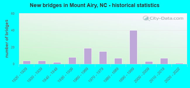
- New bridges - historical statistics
- 41920-1929
- 41930-1939
- 21940-1949
- 81950-1959
- 191960-1969
- 151970-1979
- 71980-1989
- 401990-1999
- 32000-2009
- 72010-2019
- 12020-2022
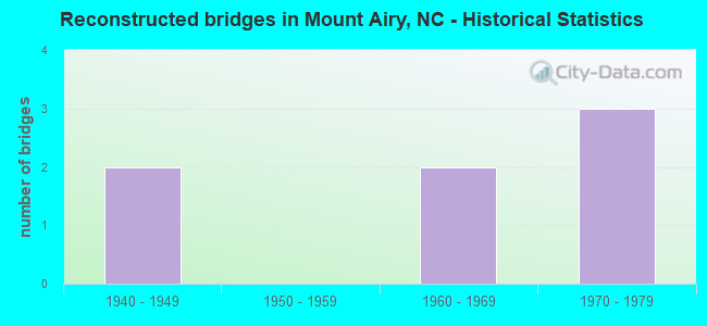
- Reconstructed bridges - Historical Statistics
- 21940-1949
- 01950-1959
- 21960-1969
- 31970-1979
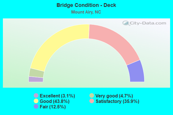
- Bridge Condition - Deck
- 3.1%Excellent
- 4.7%Very good
- 43.8%Good
- 35.9%Satisfactory
- 12.5%Fair
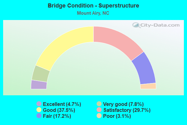
- Bridge Condition - Superstructure
- 4.7%Excellent
- 7.8%Very good
- 37.5%Good
- 29.7%Satisfactory
- 17.2%Fair
- 3.1%Poor
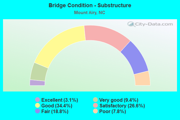
- Bridge Condition - Substructure
- 3.1%Excellent
- 9.4%Very good
- 34.4%Good
- 26.6%Satisfactory
- 18.8%Fair
- 7.8%Poor
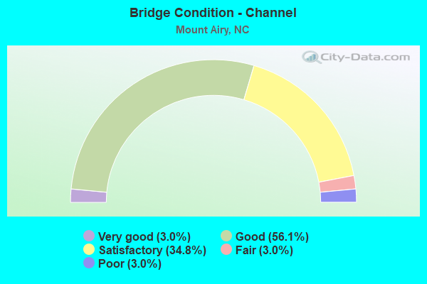
- Bridge Condition - Channel
- 3.0%Very good
- 56.1%Good
- 34.8%Satisfactory
- 3.0%Fair
- 3.0%Poor
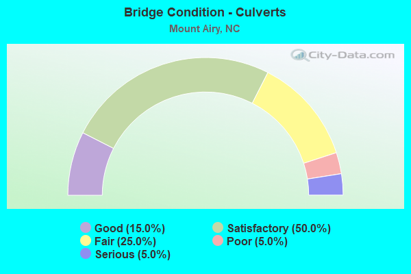
- Bridge Condition - Culverts
- 15.0%Good
- 50.0%Satisfactory
- 25.0%Fair
- 5.0%Poor
- 5.0%Serious
Find on map >> Show street view
Structure Number: 1710163, Location: .2 MI.E.JCT.SR2012 (Lat: 36.429294, Lng: -80.524806), Route carried "under" structure: State highway 1826, Year Built: 1970, Structure Length: 0. m, Average Daily Traffic: 250 (year 2019), Truck Traffic: 6%, Features Intersected: US52 SBL
Minimum Vertical Clearance: 5.05m (16.57ft), Kilometerpoint: 0.000, Lanes on structure: 2, Lanes under structure: 2, Material/Design: Steel, Design/Construction: Stringer/Multi-beam, Length of Maximum Span: 18.8m (61.7ft)
Find on map >> Show street view
Structure Number: 1710169, Location: .3 MI.E.JCT.SR2012 (Lat: 36.435958, Lng: -80.532533), Route carried "under" structure: US 52, Year Built: 1970, Structure Length: 0. m, Average Daily Traffic: 16,000 (year 2019), Truck Traffic: 14%, Features Intersected: SR1822
Minimum Vertical Clearance: 5.05m (16.57ft), Kilometerpoint: 42.367, Lanes on structure: 2, Lanes under structure: 2, Material/Design: Steel, Design/Construction: Stringer/Multi-beam, Length of Maximum Span: 48.1m (157.8ft)
Find on map >> Show street view
Structure Number: 1710169, Location: .3 MI.E.JCT.SR2012 (Lat: 36.435958, Lng: -80.532533), Route carried "under" structure: US 52, Year Built: 1970, Structure Length: 0. m, Average Daily Traffic: 16,000 (year 2019), Truck Traffic: 14%, Features Intersected: SR1822
Minimum Vertical Clearance: 4.82m (15.81ft), Kilometerpoint: 42.367, Lanes on structure: 2, Lanes under structure: 2, Material/Design: Steel, Design/Construction: Stringer/Multi-beam, Length of Maximum Span: 48.1m (157.8ft)
Find on map >> Show street view
Structure Number: 1710181, Location: .2 MI.W.JCT.SR1819 (Lat: 36.460389, Lng: -80.561375), Route carried "under" structure: US 52, Year Built: 1970, Structure Length: 0. m, Average Daily Traffic: 7,500 (year 2019), Truck Traffic: 12%, Features Intersected: SR1815
Minimum Vertical Clearance: 6.75m (22.15ft), Kilometerpoint: 43.068, Lanes on structure: 2, Lanes under structure: 3, Material/Design: Steel, Design/Construction: Stringer/Multi-beam, Length of Maximum Span: 47.2m (154.9ft)
Find on map >> Show street view
Structure Number: 1710181, Location: .2 MI.W.JCT.SR1819 (Lat: 36.460389, Lng: -80.561375), Route carried "under" structure: US 52, Year Built: 1970, Structure Length: 0. m, Average Daily Traffic: 7,500 (year 2019), Truck Traffic: 12%, Features Intersected: SR1815
Minimum Vertical Clearance: 5.43m (17.81ft), Kilometerpoint: 43.068, Lanes on structure: 2, Lanes under structure: 3, Material/Design: Steel, Design/Construction: Stringer/Multi-beam, Length of Maximum Span: 47.2m (154.9ft)
Find on map >> Show street view
Structure Number: 1710199, Location: .1 MI.W.JCT.SR1670 (Lat: 36.499406, Lng: -80.622167), Route carried "under" structure: State highway 89, Year Built: 1969, Structure Length: 0. m, Average Daily Traffic: 17,500 (year 2015), Truck Traffic: 12%, Features Intersected: US52 BYP NBL
Minimum Vertical Clearance: 5.08m (16.67ft), Kilometerpoint: 0.000, Lanes on structure: 3, Lanes under structure: 5, Material/Design: Steel continuous, Design/Construction: Stringer/Multi-beam, Length of Maximum Span: 26.2m (86.0ft)
Find on map >> Show street view
Structure Number: 1710205, Location: 0.1 MI.W.JCT.SR1670 (Lat: 36.499439, Lng: -80.622389), Route carried "under" structure: State highway 89, Year Built: 1969, Structure Length: 0. m, Average Daily Traffic: 17,500 (year 2015), Truck Traffic: 6%, Features Intersected: US52 BYP SBL
Minimum Vertical Clearance: 4.80m (15.75ft), Kilometerpoint: 0.000, Lanes on structure: 2, Lanes under structure: 5, Material/Design: Steel continuous, Design/Construction: Stringer/Multi-beam, Length of Maximum Span: 29.2m (95.8ft)
Find on map >> Show street view
Structure Number: 1710359, Location: 0.25 MI. W. JCT. SR1396 (Lat: 36.479603, Lng: -80.707764), Route carried "under" structure: Interstate 74, Year Built: 1996, Structure Length: 0. m, Average Daily Traffic: 10,000 (year 2019), Truck Traffic: 23%, Features Intersected: SR1480
Minimum Vertical Clearance: 6.50m (21.33ft), Kilometerpoint: 2.164, Lanes on structure: 2, Lanes under structure: 2, Material/Design: Steel continuous, Design/Construction: Stringer/Multi-beam, Length of Maximum Span: 31.3m (102.7ft)
Find on map >> Show street view
Structure Number: 1710359, Location: 0.25 MI. W. JCT. SR1396 (Lat: 36.479603, Lng: -80.707764), Route carried "under" structure: Interstate 74, Year Built: 1996, Structure Length: 0. m, Average Daily Traffic: 10,000 (year 2019), Truck Traffic: 23%, Features Intersected: SR1480
Minimum Vertical Clearance: 6.24m (20.47ft), Kilometerpoint: 2.164, Lanes on structure: 2, Lanes under structure: 2, Material/Design: Steel continuous, Design/Construction: Stringer/Multi-beam, Length of Maximum Span: 31.3m (102.7ft)
Find on map >> Show street view
Structure Number: 171036, Location: 0.2 MI. S. JCT. SR1356 (Lat: 36.473172, Lng: -80.695400), Route carried "under" structure: Interstate 74, Year Built: 1996, Structure Length: 0. m, Average Daily Traffic: 10,000 (year 2019), Truck Traffic: 23%, Features Intersected: SR1350
Minimum Vertical Clearance: 5.08m (16.67ft), Kilometerpoint: 2.407, Lanes on structure: 4, Lanes under structure: 2, Material/Design: Steel continuous, Design/Construction: Stringer/Multi-beam, Length of Maximum Span: 34.1m (111.9ft)
Find on map >> Show street view
Structure Number: 171036, Location: 0.2 MI. S. JCT. SR1356 (Lat: 36.473172, Lng: -80.695400), Route carried "under" structure: Interstate 74, Year Built: 1996, Structure Length: 0. m, Average Daily Traffic: 10,000 (year 2019), Truck Traffic: 23%, Features Intersected: SR1350
Minimum Vertical Clearance: 5.86m (19.23ft), Kilometerpoint: 2.407, Lanes on structure: 4, Lanes under structure: 2, Material/Design: Steel continuous, Design/Construction: Stringer/Multi-beam, Length of Maximum Span: 34.1m (111.9ft)
Find on map >> Show street view
Structure Number: 1710363, Location: 1.75 MI. W. JCT. SR2000 (Lat: 36.458539, Lng: -80.639189), Route carried "under" structure: US 601, Year Built: 1996, Structure Length: 0. m, Average Daily Traffic: 9,000 (year 2019), Truck Traffic: 12%, Features Intersected: I-74 WBL
Minimum Vertical Clearance: 5.20m (17.06ft), Kilometerpoint: 0.000, Lanes on structure: 2, Lanes under structure: 3, Material/Design: Steel continuous, Design/Construction: Stringer/Multi-beam, Length of Maximum Span: 28.9m (94.8ft)
Find on map >> Show street view
Structure Number: 1710363, Location: 1.75 MI. W. JCT. SR2000 (Lat: 36.458539, Lng: -80.639189), Route carried "under" structure: US 601, Year Built: 1996, Structure Length: 0. m, Average Daily Traffic: 9,000 (year 2019), Truck Traffic: 12%, Features Intersected: I-74 WBL
Minimum Vertical Clearance: 5.28m (17.32ft), Kilometerpoint: 0.000, Lanes on structure: 2, Lanes under structure: 2, Material/Design: Steel continuous, Design/Construction: Stringer/Multi-beam, Length of Maximum Span: 28.9m (94.8ft)
Find on map >> Show street view
Structure Number: 1710364, Location: 1.75 MI. W. JCT. SR2000 (Lat: 36.458364, Lng: -80.639436), Route carried "under" structure: US 601, Year Built: 1996, Structure Length: 0. m, Average Daily Traffic: 9,000 (year 2019), Truck Traffic: 6%, Features Intersected: I-74 EBL
Minimum Vertical Clearance: 5.74m (18.83ft), Kilometerpoint: 0.000, Lanes on structure: 2, Lanes under structure: 3, Material/Design: Steel continuous, Design/Construction: Stringer/Multi-beam, Length of Maximum Span: 28.9m (94.8ft)
Find on map >> Show street view
Structure Number: 1710364, Location: 1.75 MI. W. JCT. SR2000 (Lat: 36.458364, Lng: -80.639436), Route carried "under" structure: US 601, Year Built: 1996, Structure Length: 0. m, Average Daily Traffic: 9,000 (year 2019), Truck Traffic: 6%, Features Intersected: I-74 EBL
Minimum Vertical Clearance: 5.71m (18.73ft), Kilometerpoint: 0.000, Lanes on structure: 2, Lanes under structure: 2, Material/Design: Steel continuous, Design/Construction: Stringer/Multi-beam, Length of Maximum Span: 28.9m (94.8ft)
Find on map >> Show street view
Structure Number: 1710366, Location: .5 MI.S.JCT.SR2017 (Lat: 36.440244, Lng: -80.584689), Route carried "under" structure: Interstate 74, Year Built: 1998, Structure Length: 0. m, Average Daily Traffic: 9,750 (year 2019), Truck Traffic: 23%, Features Intersected: SR2174
Minimum Vertical Clearance: 5.42m (17.78ft), Kilometerpoint: 4.450, Lanes on structure: 2, Lanes under structure: 2, Material/Design: Steel continuous, Design/Construction: Stringer/Multi-beam, Length of Maximum Span: 32.0m (105.0ft)
Find on map >> Show street view
Structure Number: 1710366, Location: .5 MI.S.JCT.SR2017 (Lat: 36.440244, Lng: -80.584689), Route carried "under" structure: Interstate 74, Year Built: 1998, Structure Length: 0. m, Average Daily Traffic: 97,500 (year 2019), Truck Traffic: 23%, Features Intersected: SR2174
Minimum Vertical Clearance: 5.24m (17.19ft), Kilometerpoint: 4.450, Lanes on structure: 2, Lanes under structure: 2, Material/Design: Steel continuous, Design/Construction: Stringer/Multi-beam, Length of Maximum Span: 32.0m (105.0ft)
Find on map >> Show street view
Structure Number: 1710368, Location: .02 MI.W.JCT.SR2122 (Lat: 36.442450, Lng: -80.567839), Route carried "under" structure: Interstate 74, Year Built: 1998, Structure Length: 0. m, Average Daily Traffic: 7,000 (year 2015), Truck Traffic: 23%, Features Intersected: SR2015
Minimum Vertical Clearance: 5.82m (19.09ft), Kilometerpoint: 4.724, Lanes on structure: 2, Lanes under structure: 2, Material/Design: Steel, Design/Construction: Stringer/Multi-beam, Length of Maximum Span: 37.4m (122.7ft)
Find on map >> Show street view
Structure Number: 1710368, Location: .02 MI.W.JCT.SR2122 (Lat: 36.442450, Lng: -80.567839), Route carried "under" structure: Interstate 74, Year Built: 1998, Structure Length: 0. m, Average Daily Traffic: 7,000 (year 2015), Truck Traffic: 23%, Features Intersected: SR2015
Minimum Vertical Clearance: 5.31m (17.42ft), Kilometerpoint: 4.724, Lanes on structure: 2, Lanes under structure: 2, Material/Design: Steel, Design/Construction: Stringer/Multi-beam, Length of Maximum Span: 37.4m (122.7ft)
Find on map >> Show street view
Structure Number: 1710369, Location: .5 MI.W.JCT.US52 (Lat: 36.445903, Lng: -80.555394), Route carried "under" structure: State highway 2012, Year Built: 1998, Structure Length: 0. m, Average Daily Traffic: 2,700 (year 2018), Truck Traffic: 6%, Features Intersected: I-74 WBL
Minimum Vertical Clearance: 5.33m (17.49ft), Kilometerpoint: 0.000, Lanes on structure: 2, Lanes under structure: 2, Material/Design: Prestressed concrete, Design/Construction: Stringer/Multi-beam, Length of Maximum Span: 20.1m (65.9ft)
Find on map >> Show street view
Structure Number: 171037, Location: .5 MI.W.JCT.US52 (Lat: 36.445692, Lng: -80.555247), Route carried "under" structure: State highway 2012, Year Built: 1998, Structure Length: 0. m, Average Daily Traffic: 2,700 (year 2019), Truck Traffic: 6%, Features Intersected: I-74 EBL
Minimum Vertical Clearance: 4.74m (15.55ft), Kilometerpoint: 0.000, Lanes on structure: 2, Lanes under structure: 2, Material/Design: Prestressed concrete, Design/Construction: Stringer/Multi-beam, Length of Maximum Span: 20.1m (65.9ft)
Find on map >> Show street view
Structure Number: 1710372, Location: .1 MI.W.JCT.US52 (Lat: 36.446864, Lng: -80.546883), Route carried "under" structure: Ramp US 52, Year Built: 1998, Structure Length: 0. m, Average Daily Traffic: 7,500 (year 2019), Truck Traffic: 12%, Features Intersected: I-74 WBL
Minimum Vertical Clearance: 5.54m (18.18ft), Kilometerpoint: 5.181, Lanes on structure: 2, Lanes under structure: 2, Material/Design: Steel, Design/Construction: Stringer/Multi-beam, Length of Maximum Span: 31.0m (101.7ft)
Find on map >> Show street view
Structure Number: 1710372, Location: .1 MI.W.JCT.US52 (Lat: 36.446864, Lng: -80.546883), Route carried "under" structure: Ramp US 52, Year Built: 1998, Structure Length: 0. m, Average Daily Traffic: 7,500 (year 2019), Truck Traffic: 12%, Features Intersected: I-74 WBL
Minimum Vertical Clearance: 6.00m (19.69ft), Kilometerpoint: 5.181, Lanes on structure: 2, Lanes under structure: 1, Material/Design: Steel, Design/Construction: Stringer/Multi-beam, Length of Maximum Span: 31.0m (101.7ft)
Find on map >> Show street view
Structure Number: 1710373, Location: .1 MI.W.JCT.US52 (Lat: 36.446567, Lng: -80.546717), Route carried "under" structure: Ramp US 52, Year Built: 1998, Structure Length: 0. m, Average Daily Traffic: 7,500 (year 2019), Truck Traffic: 12%, Features Intersected: I-74 EBL
Minimum Vertical Clearance: 5.24m (17.19ft), Kilometerpoint: 0.000, Lanes on structure: 2, Lanes under structure: 1, Material/Design: Steel, Design/Construction: Stringer/Multi-beam, Length of Maximum Span: 32.3m (106.0ft)
Find on map >> Show street view
Structure Number: 1710373, Location: .1 MI.W.JCT.US52 (Lat: 36.446567, Lng: -80.546717), Route carried "under" structure: Ramp US 52, Year Built: 1998, Structure Length: 0. m, Average Daily Traffic: 7,500 (year 2019), Truck Traffic: 12%, Features Intersected: I-74 EBL
Minimum Vertical Clearance: 5.24m (17.19ft), Kilometerpoint: 0.000, Lanes on structure: 2, Lanes under structure: 2, Material/Design: Steel, Design/Construction: Stringer/Multi-beam, Length of Maximum Span: 32.3m (106.0ft)