Bridge Statistics for Mount Vernon, New York (NY)
Condition, Traffic, Stress, Structural Evaluation, Project Costs
- National Bridge Inventory (NBI) Statistics
- 65Number of bridges
- 614ft / 187mTotal length
- $272,345,000Total costs
- 1,233,075Total average daily traffic
- 20,893Total average daily truck traffic
- National Bridge Inventory (NBI) Registered Bridges for Mount Vernon
- No street view available for this location
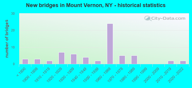
- New bridges - historical statistics
- 3Before 1900
- 31900-1909
- 21910-1919
- 71920-1929
- 61930-1939
- 41940-1949
- 21950-1959
- 241960-1969
- 51970-1979
- 51980-1989
- 22010-2019
- 22020-2022
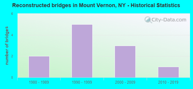
- Reconstructed bridges - Historical Statistics
- 21980-1989
- 51990-1999
- 32000-2009
- 12010-2019
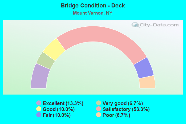
- Bridge Condition - Deck
- 13.3%Excellent
- 6.7%Very good
- 10.0%Good
- 53.3%Satisfactory
- 10.0%Fair
- 6.7%Poor
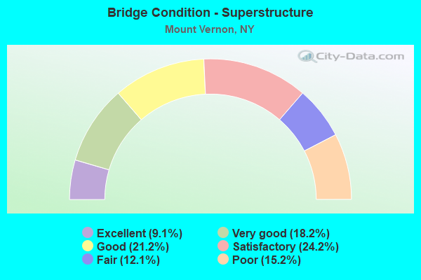
- Bridge Condition - Superstructure
- 9.1%Excellent
- 18.2%Very good
- 21.2%Good
- 24.2%Satisfactory
- 12.1%Fair
- 15.2%Poor
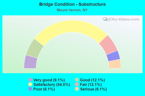
- Bridge Condition - Substructure
- 9.1%Very good
- 12.1%Good
- 54.5%Satisfactory
- 12.1%Fair
- 6.1%Poor
- 6.1%Serious
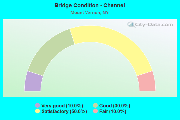
- Bridge Condition - Channel
- 10.0%Very good
- 30.0%Good
- 50.0%Satisfactory
- 10.0%Fair
Find on map >> Show street view
Structure Number: 107255, Location: 0.8 MI E INT & NYSTWAY87I (Lat: 40.927786, Lng: -73.840117), Route carried "on" structure: City street 907K, Year Built: 1983, Status: Open, Structure Length: 31.39m (102.99ft), Average Daily Traffic: 66,133 (year 2008), Truck Traffic: 2%, Average Future Daily Traffic: 93,293 (year 2040), Design Load: HS 20, Features Intersected: 907G X SB, MC QUESTEN A
Minimum Vertical Clearance: 30+ m (98+ ft), Kilometerpoint: 3.041, Lanes on structure: 2, Lanes under structure: 14, Base Highway Network: Yes, Owner: State Highway Agency, Approaching Roadway Width: 12.2m (40.0ft), Material/Design: Steel continuous, Design/Construction: Stringer/Multi-beam, Number Of Spans In Main Unit: 8, Length of Maximum Span: 42.3m (138.8ft), Curb-To-Curb Width: 12.3m (40.4ft), Out-to-Out Width: 13.3m (43.6ft)
Condition: Deck: Satisfactory, Superstructure: Good, Substructure: Poor, Channel: Satisfactory, Operating Rating: 49.9 metric tons, Method Used To Determine Operating Rating: Load and Resistance Factor Rating (LRFR) rating reported by rating factor(RF) method using HL-93 loadings, Inventory Rating: 38.6 metric tons, Method Used To Determine Inventory Rating: Load and Resistance Factor Rating (LRFR) rating reported by rating factor(RF) method using HL-93 loadings, Structural Evaluation: Meets minimum limits, Deck Geometry: Better than present minimum criteria, Underclear: High priority of corrective action, Waterway Adequacy: Superior to present desirable criteria, Approach Roadway Alignment: Equal to present desirable criteria, Length Of Structure Improvement: 31.39m (102.99ft), Designated Inspection Frequency: Every 24 months, Inspection Date: August 2021, Bridge Improvement Cost: $15,914,000, Roadway Improvement Cost: $9,320,000, Total Project Cost: $25,234,000 ( Estimate for 2021), Deck Structure Type: Concrete Cast-file-Place, Wearing Surface/Protective System: Wearing Surface: Integral Concrete, Deck Protection: Epoxy Coated Reinforcing
Find on map >> Show street view
Structure Number: 222522, Location: 1.2 MI NW OF PELHAM MANOR (Lat: 40.904947, Lng: -73.827369), Route carried "on" structure: City street , Year Built: 1912, Status: Open, Structure Length: 2.74m (8.99ft), Average Daily Traffic: 10,157 (year 2019), Truck Traffic: 4%, Average Future Daily Traffic: 12,338 (year 2040), Features Intersected: BUILDING, Facility Carried by Structure: SOUTH FULTON AVE
Minimum Vertical Clearance: 30+ m (98+ ft), Kilometerpoint: 1.545, Lanes on structure: 4, Owner: City or Municipal Highway Agency, Approaching Roadway Width: 16.8m (55.1ft), Skew: 2 degrees, Material/Design: Steel, Design/Construction: Stringer/Multi-beam, Number Of Spans In Main Unit: 4, Length of Maximum Span: 6.7m (22.0ft), Curb or Sidewalk Widths: Left: 5.5m (18.0ft), Right: 3.8m (12.5ft), Curb-To-Curb Width: 16.8m (55.1ft), Out-to-Out Width: 26.7m (87.6ft)
Condition: Deck: Fair, Superstructure: Poor, Substructure: Serious, Operating Rating: 50.5 metric tons, Method Used To Determine Operating Rating: Load and Resistance Factor Rating (LRFR) rating reported by rating factor(RF) method using HL-93 loadings, Inventory Rating: 38.9 metric tons, Method Used To Determine Inventory Rating: Load and Resistance Factor Rating (LRFR) rating reported by rating factor(RF) method using HL-93 loadings, Structural Evaluation: High priority of corrective action, Deck Geometry: Somewhat better than minimum adequacy, Approach Roadway Alignment: Equal to present desirable criteria, Length Of Structure Improvement: 2.74m (8.99ft), Designated Inspection Frequency: Every 12 months, Critical Feature Inspection Frequency: Every 12 months, Inspection Date: December 2021, Critical Feature Inspection Date: December 2021, Bridge Improvement Cost: $5,382,000, Roadway Improvement Cost: $3,152,000, Total Project Cost: $8,534,000 ( Estimate for 2021), Deck Structure Type: Concrete Cast-file-Place, Wearing Surface/Protective System: Wearing Surface: Bituminous
Find on map >> Show street view
Structure Number: 222523, Location: 1.3 MI NW OF PELHAM MANOR (Lat: 40.908719, Lng: -73.826761), Route carried "on" structure: City street , Year Built: 1912, Year Reconstructed: 2006, Status: Posted for load, Structure Length: 4.57m (14.99ft), Average Daily Traffic: 6,467 (year 2017), Truck Traffic: 3%, Average Future Daily Traffic: 7,856 (year 2040), Features Intersected: UNIVERSAL MTL BLG, Facility Carried by Structure: EAST 3RD STREET
Minimum Vertical Clearance: 30+ m (98+ ft), Kilometerpoint: 0.756, Lanes on structure: 2, Owner: City or Municipal Highway Agency, Approaching Roadway Width: 12.5m (41.0ft), Skew: 5 degrees, Material/Design: Steel, Design/Construction: Stringer/Multi-beam, Number Of Spans In Main Unit: 4, Length of Maximum Span: 10.9m (35.8ft), Curb or Sidewalk Widths: Left: 3.5m (11.5ft), Right: 3.3m (10.8ft), Curb-To-Curb Width: 12.2m (40.0ft), Out-to-Out Width: 20.6m (67.6ft)
Condition: Deck: Poor, Superstructure: Poor, Substructure: Serious, Operating Rating: 9.1 metric tons, Method Used To Determine Operating Rating: Load Factor (LF), Inventory Rating: 5.4 metric tons, Method Used To Determine Inventory Rating: Load Factor (LF), Structural Evaluation: High priority of corrective action, Deck Geometry: Somewhat better than minimum adequacy, Approach Roadway Alignment: Equal to present desirable criteria, Bridge Posting: Required (Relationship of Operating Rating to Maximum Legal Load: > 39.9% below), Length Of Structure Improvement: 4.57m (14.99ft), Designated Inspection Frequency: Every 12 months, Critical Feature Inspection Frequency: Every 12 months, Inspection Date: December 2021, Critical Feature Inspection Date: December 2021, Bridge Improvement Cost: $6,175,000, Roadway Improvement Cost: $3,616,000, Total Project Cost: $9,791,000 ( Estimate for 2021), Deck Structure Type: Concrete Cast-file-Place, Wearing Surface/Protective System: Wearing Surface: Bituminous
Find on map >> Show street view
Structure Number: 22625, Location: 1.9 MI W OF PELHAM (Lat: 40.910192, Lng: -73.843967), Route carried "on" structure: City street , Year Built: 1900, Year Reconstructed: 1997, Status: Open, Structure Length: 3.17m (10.40ft), Average Daily Traffic: 4,923 (year 2018), Truck Traffic: 4%, Average Future Daily Traffic: 4,946 (year 2040), Design Load: HS 25 or greater, Features Intersected: MNRR NH LINE, Facility Carried by Structure: WEST LINCOLN AVE
Minimum Vertical Clearance: 30+ m (98+ ft), Kilometerpoint: 0.016, Lanes on structure: 4, Owner: Railroad, Maintenance Responsibility: City or Municipal Highway Agency, Approaching Roadway Width: 18.3m (60.0ft), Material/Design: Steel, Design/Construction: Stringer/Multi-beam, Number Of Spans In Main Unit: 1, Length of Maximum Span: 30.4m (99.7ft), Curb or Sidewalk Widths: Left: 2.8m (9.2ft), Right: 2.8m (9.2ft), Curb-To-Curb Width: 18.3m (60.0ft), Out-to-Out Width: 24.4m (80.1ft)
Condition: Deck: Excellent, Superstructure: Excellent, Substructure: Good, Operating Rating: 95.3 metric tons, Method Used To Determine Operating Rating: Allowable Stress (AS), Inventory Rating: 45.4 metric tons, Method Used To Determine Inventory Rating: Allowable Stress (AS), Structural Evaluation: Better than present minimum criteria, Deck Geometry: Somewhat better than minimum adequacy, Underclear: Meets minimum limits, Approach Roadway Alignment: Equal to present desirable criteria, Length Of Structure Improvement: 3.16m (10.37ft), Designated Inspection Frequency: Every 24 months, Inspection Date: December 2020, Bridge Improvement Cost: $5,510,000, Roadway Improvement Cost: $3,227,000, Total Project Cost: $8,737,000 ( Estimate for 2021), Deck Structure Type: Concrete Cast-file-Place, Wearing Surface/Protective System: Wearing Surface: Integral Concrete, Deck Protection: Epoxy Coated Reinforcing
Find on map >> Show street view
Structure Number: 226512, Location: 1.5 MILES WEST OF PELHAM (Lat: 40.911956, Lng: -73.837175), Route carried "on" structure: City street , Year Built: 1894, Year Reconstructed: 1996, Status: Open, Structure Length: 2.44m (8.01ft), Average Daily Traffic: 5,404 (year 2016), Truck Traffic: 3%, Average Future Daily Traffic: 6,564 (year 2040), Design Load: H 20, Features Intersected: MNRR NH LINE, Facility Carried by Structure: GRAMATAN AVENUE
Minimum Vertical Clearance: 30+ m (98+ ft), Kilometerpoint: 0.016, Lanes on structure: 2, Owner: Railroad, Maintenance Responsibility: City or Municipal Highway Agency, Approaching Roadway Width: 15.2m (49.9ft), Material/Design: Steel, Design/Construction: Stringer/Multi-beam, Number Of Spans In Main Unit: 2, Length of Maximum Span: 18.3m (60.0ft), Curb or Sidewalk Widths: Left: 3.8m (12.5ft), Right: 3.8m (12.5ft), Curb-To-Curb Width: 15.2m (49.9ft), Out-to-Out Width: 23.3m (76.4ft)
Condition: Deck: Poor, Superstructure: Fair, Substructure: Poor, Operating Rating: 36.0 metric tons, Method Used To Determine Operating Rating: Load and Resistance Factor Rating (LRFR) rating reported by rating factor(RF) method using HL-93 loadings, Inventory Rating: 27.9 metric tons, Method Used To Determine Inventory Rating: Load and Resistance Factor Rating (LRFR) rating reported by rating factor(RF) method using HL-93 loadings, Structural Evaluation: Meets minimum limits, Deck Geometry: Superior to present desirable criteria, Underclear: High priority of corrective action, Approach Roadway Alignment: Equal to present desirable criteria, Length Of Structure Improvement: 2.43m (7.97ft), Designated Inspection Frequency: Every 24 months, Inspection Date: December 2021, Bridge Improvement Cost: $3,996,000, Roadway Improvement Cost: $2,340,000, Total Project Cost: $6,335,000 ( Estimate for 2021), Deck Structure Type: Concrete Cast-file-Place, Wearing Surface/Protective System: Wearing Surface: Bituminous
Find on map >> Show street view
Structure Number: 334811, Location: 0.6 MI NW OF PELHAM MANOR (Lat: 40.902578, Lng: -73.815183), Route carried "on" structure: County highway , Year Built: 1928, Year Reconstructed: 1999, Status: Open, Structure Length: 1.01m (3.31ft), Average Daily Traffic: 9,383 (year 2018), Truck Traffic: 3%, Average Future Daily Traffic: 11,398 (year 2040), Design Load: HS 25 or greater, Features Intersected: HUTCHINSON RIVER, Facility Carried by Structure: SANFORD BOULEVARD
Minimum Vertical Clearance: 32.69m (107.25ft), Kilometerpoint: 0.000, Lanes on structure: 4, Owner: County Highway Agency, Approaching Roadway Width: 15.2m (49.9ft), Skew: 22 degrees, Material/Design: Prestressed concrete, Design/Construction: Box Beam or Girders - Multiple, Number Of Spans In Main Unit: 1, Length of Maximum Span: 9.4m (30.8ft), Curb or Sidewalk Widths: Left: 3.4m (11.2ft), Right: 2.3m (7.5ft), Curb-To-Curb Width: 15.3m (50.2ft), Out-to-Out Width: 21.7m (71.2ft)
Condition: Deck: Very good, Superstructure: Very good, Substructure: Very good, Channel: Fair, Operating Rating: 56.4 metric tons, Method Used To Determine Operating Rating: Load and Resistance Factor Rating (LRFR) rating reported by rating factor(RF) method using HL-93 loadings, Inventory Rating: 43.4 metric tons, Method Used To Determine Inventory Rating: Load and Resistance Factor Rating (LRFR) rating reported by rating factor(RF) method using HL-93 loadings, Structural Evaluation: Equal to present desirable criteria, Deck Geometry: High priority of corrective action, Waterway Adequacy: Meets minimum limits, Approach Roadway Alignment: Equal to present desirable criteria, Length Of Structure Improvement: 1.00m (3.28ft), Designated Inspection Frequency: Every 24 months, Inspection Date: May 2021, Bridge Improvement Cost: $776,000, Roadway Improvement Cost: $454,000, Total Project Cost: $1,230,000 ( Estimate for 2021), Wearing Surface/Protective System: Wearing Surface: Integral Concrete
Find on map >> Show street view
Structure Number: 334816, Location: 1.1 MI S JCT RTS BRP+CCP (Lat: 40.913869, Lng: -73.850378), Route carried "on" structure: County highway 984E, Year Built: 1954, Year Reconstructed: 1999, Status: Open, Structure Length: 4.72m (15.49ft), Average Daily Traffic: 12,965 (year 2011), Truck Traffic: 11%, Average Future Daily Traffic: 13,025 (year 2040), Design Load: HS 25 or greater, Features Intersected: 907GX SB, RTE 907G, BRON
Minimum Vertical Clearance: 30+ m (98+ ft), Kilometerpoint: 0.000, Lanes on structure: 3, Lanes under structure: 6, Owner: County Highway Agency, Approaching Roadway Width: 12.8m (42.0ft), Skew: 1 degrees, Material/Design: Steel continuous, Design/Construction: Stringer/Multi-beam, Number Of Spans In Main Unit: 3, Length of Maximum Span: 19.2m (63.0ft), Curb or Sidewalk Widths: Left: 2.8m (9.2ft), Right: 2.8m (9.2ft), Curb-To-Curb Width: 17.1m (56.1ft), Out-to-Out Width: 23.3m (76.4ft)
Condition: Deck: Good, Superstructure: Very good, Substructure: Good, Channel: Good, Operating Rating: 48.0 metric tons, Method Used To Determine Operating Rating: Load and Resistance Factor Rating (LRFR) rating reported by rating factor(RF) method using HL-93 loadings, Inventory Rating: 36.9 metric tons, Method Used To Determine Inventory Rating: Load and Resistance Factor Rating (LRFR) rating reported by rating factor(RF) method using HL-93 loadings, Structural Evaluation: Better than present minimum criteria, Deck Geometry: Superior to present desirable criteria, Underclear: High priority of corrective action, Waterway Adequacy: Somewhat better than minimum adequacy, Approach Roadway Alignment: Equal to present desirable criteria, Length Of Structure Improvement: 4.72m (15.49ft), Designated Inspection Frequency: Every 24 months, Inspection Date: April 2021, Bridge Improvement Cost: $5,878,000, Roadway Improvement Cost: $3,442,000, Total Project Cost: $9,320,000 ( Estimate for 2021), Deck Structure Type: Concrete Cast-file-Place, Wearing Surface/Protective System: Wearing Surface: Integral Concrete, Deck Protection: Epoxy Coated Reinforcing
Find on map >> Show street view
Structure Number: 334837, Location: 1.3 MI E DUNWOODIE (Lat: 40.927114, Lng: -73.839833), Route carried "on" structure: City street , Year Built: 1923, Year Reconstructed: 2012, Status: Open, Structure Length: 17.74m (58.20ft), Average Daily Traffic: 8,979 (year 2017), Truck Traffic: 3%, Average Future Daily Traffic: 10,907 (year 2040), Features Intersected: 907G BRP SB, 907G BRP, Facility Carried by Structure: BROAD STREET
Minimum Vertical Clearance: 30+ m (98+ ft), Kilometerpoint: 0.000, Lanes on structure: 2, Lanes under structure: 10, Owner: County Highway Agency, Approaching Roadway Width: 7.9m (25.9ft), Material/Design: Concrete, Design/Construction: Arch - Deck, Number Of Spans In Main Unit: 6, Length of Maximum Span: 28.6m (93.8ft), Curb or Sidewalk Widths: Left: 2.1m (6.9ft), Right: 2.1m (6.9ft), Curb-To-Curb Width: 7.9m (25.9ft), Out-to-Out Width: 12.2m (40.0ft)
Condition: Deck: Satisfactory, Superstructure: Good, Substructure: Satisfactory, Channel: Good, Operating Rating: 47.1 metric tons, Method Used To Determine Operating Rating: Field evaluation and documented engineering judgment, Inventory Rating: 11.7 metric tons, Method Used To Determine Inventory Rating: Field evaluation and documented engineering judgment, Structural Evaluation: High priority of corrective action, Deck Geometry: High priority of corrective action, Underclear: High priority of corrective action, Waterway Adequacy: Meets minimum limits, Approach Roadway Alignment: Equal to present desirable criteria, Length Of Structure Improvement: 17.73m (58.17ft), Designated Inspection Frequency: Every 24 months, Inspection Date: October 2021, Bridge Improvement Cost: $15,512,000, Roadway Improvement Cost: $9,084,000, Total Project Cost: $24,596,000 ( Estimate for 2021)
Find on map >> Show street view
Structure Number: 3348999, Location: 0.2 MI N JCT RTS BRP+CCP (Lat: 40.929867, Lng: -73.839283), Route carried "on" structure: Ramp County highway 907G, Year Built: 1941, Status: Open, Structure Length: 3.81m (12.50ft), Truck Traffic: 2%, Design Load: H 20, Features Intersected: 907GX (NB), RTE 907G
Minimum Vertical Clearance: 30+ m (98+ ft), Kilometerpoint: 0.193, Lanes on structure: 1, Lanes under structure: 9, Owner: County Highway Agency, Approaching Roadway Width: 5.5m (18.0ft), Skew: 3 degrees, Material/Design: Steel, Design/Construction: Stringer/Multi-beam, Number Of Spans In Main Unit: 1, Length of Maximum Span: 34.1m (111.9ft), Curb or Sidewalk Widths: Left: 0.0m, Right: 1.6m (5.2ft), Curb-To-Curb Width: 5.5m (18.0ft), Out-to-Out Width: 17.6m (57.7ft)
Condition: Deck: Good, Superstructure: Fair, Substructure: Satisfactory, Operating Rating: 31.8 metric tons, Method Used To Determine Operating Rating: Load Factor (LF), Inventory Rating: 18.1 metric tons, Method Used To Determine Inventory Rating: Load Factor (LF), Structural Evaluation: Meets minimum limits, Deck Geometry: Meets minimum limits, Underclear: High priority of corrective action, Approach Roadway Alignment: Equal to present minimum criteria, Length Of Structure Improvement: 3.81m (12.50ft), Designated Inspection Frequency: Every 24 months, Inspection Date: December 2021, Bridge Improvement Cost: $4,754,000, Roadway Improvement Cost: $2,784,000, Total Project Cost: $7,538,000 ( Estimate for 2021), Deck Structure Type: Concrete Cast-file-Place, Wearing Surface/Protective System: Wearing Surface: Bituminous
Find on map >> Show street view
Structure Number: 3365069, Location: 2.2 MI NW OF PELHAM (Lat: 40.923408, Lng: -73.843203), Route carried "on" structure: Ramp County highway , Year Built: 1970, Status: Open, Structure Length: 1.89m (6.20ft), Truck Traffic: 2%, Features Intersected: BRONX RIVER, Facility Carried by Structure: 907G NB-907K RAMP
Minimum Vertical Clearance: 30+ m (98+ ft), Kilometerpoint: 0.708, Lanes on structure: 2, Owner: County Highway Agency, Approaching Roadway Width: 11.4m (37.4ft), Skew: 30 degrees, Material/Design: Steel, Design/Construction: Culvert, Number Of Spans In Main Unit: 3, Length of Maximum Span: 5.5m (18.0ft)
Condition: Channel: Satisfactory, Culverts: Satisfactory, Operating Rating: 76.5 metric tons, Method Used To Determine Operating Rating: Field evaluation and documented engineering judgment, Inventory Rating: 32.7 metric tons, Method Used To Determine Inventory Rating: Field evaluation and documented engineering judgment, Structural Evaluation: Equal to present minimum criteria, Waterway Adequacy: Meets minimum limits, Approach Roadway Alignment: Equal to present desirable criteria, Length Of Structure Improvement: 1.88m (6.17ft), Designated Inspection Frequency: Every 24 months, Inspection Date: March 2021, Bridge Improvement Cost: $731,000, Roadway Improvement Cost: $428,000, Total Project Cost: $1,160,000 ( Estimate for 2021)
Find on map >> Show street view
Structure Number: 5016531, Location: 1.0 MI E JCT RTS CCP+BRP (Lat: 40.922925, Lng: -73.822928), Route carried "on" structure: Ramp State highway , Year Built: 1967, Status: Open, Structure Length: 3.08m (10.10ft), Average Daily Traffic: 59,355 (year 2007), Truck Traffic: 4%, Average Future Daily Traffic: 83,097 (year 2027), Design Load: HS 20, Features Intersected: N.COLUMBUS CR 22, Facility Carried by Structure: RAMP X TO 907K E.
Minimum Vertical Clearance: 30+ m (98+ ft), Kilometerpoint: 4.811, Lanes on structure: 1, Lanes under structure: 5, Base Highway Network: Yes, Owner: State Highway Agency, Approaching Roadway Width: 9.1m (29.9ft), Material/Design: Steel, Design/Construction: Stringer/Multi-beam, Number Of Spans In Main Unit: 1, Length of Maximum Span: 29.5m (96.8ft), Curb-To-Curb Width: 9.0m (29.5ft), Out-to-Out Width: 9.7m (31.8ft)
Condition: Deck: Satisfactory, Superstructure: Good, Substructure: Satisfactory, Operating Rating: 56.1 metric tons, Method Used To Determine Operating Rating: Load and Resistance Factor Rating (LRFR) rating reported by rating factor(RF) method using HL-93 loadings, Inventory Rating: 43.4 metric tons, Method Used To Determine Inventory Rating: Load and Resistance Factor Rating (LRFR) rating reported by rating factor(RF) method using HL-93 loadings, Structural Evaluation: Equal to present minimum criteria, Deck Geometry: Superior to present desirable criteria, Underclear: Meets minimum limits, Approach Roadway Alignment: Equal to present desirable criteria, Length Of Structure Improvement: 3.07m (10.07ft), Designated Inspection Frequency: Every 24 months, Inspection Date: June 2020, Bridge Improvement Cost: $1,984,000, Roadway Improvement Cost: $1,162,000, Total Project Cost: $3,145,000 ( Estimate for 2021), Deck Structure Type: Concrete Cast-file-Place, Wearing Surface/Protective System: Wearing Surface: Integral Concrete
Find on map >> Show street view
Structure Number: 5016532, Location: 1.0 MI E JCT RTS CCP+BRP (Lat: 40.923064, Lng: -73.822817), Route carried "on" structure: State highway 907K, Year Built: 1967, Status: Open, Structure Length: 3.08m (10.10ft), Average Daily Traffic: 51,815 (year 2007), Truck Traffic: 2%, Average Future Daily Traffic: 73,094 (year 2040), Design Load: HS 20, Features Intersected: N.COLUMBUS CR 22
Minimum Vertical Clearance: 30+ m (98+ ft), Kilometerpoint: 4.811, Lanes on structure: 4, Lanes under structure: 5, Base Highway Network: Yes, Owner: State Highway Agency, Approaching Roadway Width: 20.4m (66.9ft), Material/Design: Steel, Design/Construction: Stringer/Multi-beam, Number Of Spans In Main Unit: 1, Length of Maximum Span: 29.5m (96.8ft), Curb-To-Curb Width: 20.5m (67.3ft), Out-to-Out Width: 21.5m (70.5ft)
Condition: Deck: Satisfactory, Superstructure: Good, Substructure: Satisfactory, Operating Rating: 52.5 metric tons, Method Used To Determine Operating Rating: Load and Resistance Factor Rating (LRFR) rating reported by rating factor(RF) method using HL-93 loadings, Inventory Rating: 40.5 metric tons, Method Used To Determine Inventory Rating: Load and Resistance Factor Rating (LRFR) rating reported by rating factor(RF) method using HL-93 loadings, Structural Evaluation: Equal to present minimum criteria, Deck Geometry: Equal to present minimum criteria, Underclear: High priority of corrective action, Approach Roadway Alignment: Equal to present desirable criteria, Length Of Structure Improvement: 3.07m (10.07ft), Designated Inspection Frequency: Every 24 months, Inspection Date: June 2020, Bridge Improvement Cost: $4,120,000, Roadway Improvement Cost: $2,413,000, Total Project Cost: $6,533,000 ( Estimate for 2021), Deck Structure Type: Concrete Cast-file-Place, Wearing Surface/Protective System: Wearing Surface: Integral Concrete
Find on map >> Show street view
Structure Number: 5016533, Location: 1.0 MI E JCT RTS CCP+BRP (Lat: 40.923222, Lng: -73.822644), Route carried "on" structure: State highway 907K, Year Built: 1967, Status: Open, Structure Length: 3.08m (10.10ft), Average Daily Traffic: 103,629 (year 2007), Truck Traffic: 2%, Average Future Daily Traffic: 146,189 (year 2040), Design Load: HS 20, Features Intersected: N.COLUMBUS CR 22
Minimum Vertical Clearance: 30+ m (98+ ft), Kilometerpoint: 4.811, Lanes on structure: 5, Lanes under structure: 5, Base Highway Network: Yes, Owner: State Highway Agency, Approaching Roadway Width: 22.6m (74.1ft), Skew: 2 degrees, Material/Design: Steel, Design/Construction: Stringer/Multi-beam, Number Of Spans In Main Unit: 1, Length of Maximum Span: 29.5m (96.8ft), Curb-To-Curb Width: 22.4m (73.5ft), Out-to-Out Width: 23.3m (76.4ft)
Condition: Deck: Fair, Superstructure: Good, Substructure: Satisfactory, Operating Rating: 46.3 metric tons, Method Used To Determine Operating Rating: Load and Resistance Factor Rating (LRFR) rating reported by rating factor(RF) method using HL-93 loadings, Inventory Rating: 35.6 metric tons, Method Used To Determine Inventory Rating: Load and Resistance Factor Rating (LRFR) rating reported by rating factor(RF) method using HL-93 loadings, Structural Evaluation: Equal to present minimum criteria, Deck Geometry: Meets minimum limits, Underclear: High priority of corrective action, Approach Roadway Alignment: Equal to present desirable criteria, Length Of Structure Improvement: 3.07m (10.07ft), Designated Inspection Frequency: Every 24 months, Inspection Date: June 2020, Bridge Improvement Cost: $4,609,000, Roadway Improvement Cost: $2,699,000, Total Project Cost: $7,309,000 ( Estimate for 2021), Deck Structure Type: Concrete Cast-file-Place, Wearing Surface/Protective System: Wearing Surface: Integral Concrete
Find on map >> Show street view
Structure Number: 506932, Location: 0.1 MI N JCT RTS CCP+BRP (Lat: 40.928381, Lng: -73.839694), Route carried "on" structure: Ramp City street 907K, Year Built: 1974, Status: Open, Structure Length: 19.14m (62.80ft), Truck Traffic: 2%, Features Intersected: 907 GX SB, MCQUESTEN PKW
Minimum Vertical Clearance: 6.53m (21.42ft), Kilometerpoint: 0.161, Lanes on structure: 1, Lanes under structure: 11, Owner: State Highway Agency, Approaching Roadway Width: 5.8m (19.0ft), Material/Design: Steel, Design/Construction: Stringer/Multi-beam, Number Of Spans In Main Unit: 6, Length of Maximum Span: 36.8m (120.7ft), Curb or Sidewalk Widths: Left: 1.4m (4.6ft), Right: 1.4m (4.6ft), Curb-To-Curb Width: 5.8m (19.0ft), Out-to-Out Width: 9.4m (30.8ft)
Condition: Deck: Satisfactory, Superstructure: Fair, Substructure: Fair, Channel: Satisfactory, Operating Rating: 91.4 metric tons, Method Used To Determine Operating Rating: Field evaluation and documented engineering judgment, Inventory Rating: 32.7 metric tons, Method Used To Determine Inventory Rating: Field evaluation and documented engineering judgment, Structural Evaluation: Somewhat better than minimum adequacy, Deck Geometry: Meets minimum limits, Underclear: High priority of corrective action, Waterway Adequacy: Meets minimum limits, Approach Roadway Alignment: Equal to present desirable criteria, Length Of Structure Improvement: 19.14m (62.80ft), Designated Inspection Frequency: Every 24 months, Inspection Date: October 2021, Bridge Improvement Cost: $7,098,000, Roadway Improvement Cost: $4,157,000, Total Project Cost: $11,255,000 ( Estimate for 2021), Deck Structure Type: Concrete Cast-file-Place, Wearing Surface/Protective System: Wearing Surface: Integral Concrete
Find on map >> Show street view
Structure Number: 506932A, Location: .1 MI N JCT CCP AND BRP (Lat: 40.928767, Lng: -73.839222), Route carried "on" structure: Ramp Other road , Year Built: 1983, Status: Open, Structure Length: 11.73m (38.48ft), Average Daily Traffic: 24,243 (year 1997), Truck Traffic: 4%, Average Future Daily Traffic: 33,940 (year 2017), Design Load: HS 20, Features Intersected: BRONX RIVER, Facility Carried by Structure: RAMP TO 907G
Minimum Vertical Clearance: 30+ m (98+ ft), Kilometerpoint: 0.000, Lanes on structure: 1, Owner: State Highway Agency, Approaching Roadway Width: 7.0m (23.0ft), Material/Design: Steel continuous, Design/Construction: Stringer/Multi-beam, Number Of Spans In Main Unit: 3, Length of Maximum Span: 50.9m (167.0ft), Curb-To-Curb Width: 7.0m (23.0ft), Out-to-Out Width: 8.0m (26.2ft)
Condition: Deck: Satisfactory, Superstructure: Very good, Substructure: Good, Channel: Very good, Operating Rating: 83.5 metric tons, Method Used To Determine Operating Rating: Field evaluation and documented engineering judgment, Inventory Rating: 32.7 metric tons, Method Used To Determine Inventory Rating: Field evaluation and documented engineering judgment, Structural Evaluation: Better than present minimum criteria, Deck Geometry: Equal to present minimum criteria, Waterway Adequacy: Equal to present minimum criteria, Approach Roadway Alignment: Equal to present desirable criteria, Length Of Structure Improvement: 11.73m (38.48ft), Designated Inspection Frequency: Every 24 months, Inspection Date: September 2020, Bridge Improvement Cost: $3,615,000, Roadway Improvement Cost: $2,117,000, Total Project Cost: $5,731,000 ( Estimate for 2021), Deck Structure Type: Concrete Cast-file-Place, Wearing Surface/Protective System: Wearing Surface: Integral Concrete, Deck Protection: Epoxy Coated Reinforcing
Find on map >> Show street view
Structure Number: 5500089, Location: 1.3 MI N JCT RTS HRP<1 (Lat: 40.911569, Lng: -73.813708), Route carried "on" structure: City street 907W, Year Built: 2018, Status: Open, Structure Length: 1.04m (3.41ft), Average Daily Traffic: 93,396 (year 2005), Truck Traffic: 2%, Average Future Daily Traffic: 131,753 (year 2040), Features Intersected: HUTCHINSON RIVER
Minimum Vertical Clearance: 30+ m (98+ ft), Kilometerpoint: 2.558, Lanes on structure: 4, Base Highway Network: Yes, Owner: State Highway Agency, Approaching Roadway Width: 21.6m (70.9ft), Skew: 20 degrees, Material/Design: Concrete, Design/Construction: Arch - Deck, Number Of Spans In Main Unit: 1, Length of Maximum Span: 9.8m (32.2ft), Curb-To-Curb Width: 21.6m (70.9ft), Out-to-Out Width: 24.1m (79.1ft)
Condition: Deck: Very good, Superstructure: Very good, Substructure: Very good, Channel: Good, Operating Rating: 93.4 metric tons, Method Used To Determine Operating Rating: Load Factor (LF), Inventory Rating: 58.1 metric tons, Method Used To Determine Inventory Rating: Load Factor (LF), Structural Evaluation: Equal to present desirable criteria, Deck Geometry: Better than present minimum criteria, Waterway Adequacy: Equal to present minimum criteria, Approach Roadway Alignment: Better than present minimum criteria, Length Of Structure Improvement: 1.03m (3.38ft), Designated Inspection Frequency: Every 24 months, Inspection Date: July 2020, Bridge Improvement Cost: $957,000, Roadway Improvement Cost: $561,000, Total Project Cost: $1,518,000 ( Estimate for 2021), Wearing Surface/Protective System: Wearing Surface: Bituminous
Find on map >> Show street view
Structure Number: 55001, Location: 1.7 MI N JCT RTS HRP & 1 (Lat: 40.916297, Lng: -73.811858), Route carried "on" structure: County highway , Year Built: 1935, Status: Closed, Structure Length: 2.10m (6.89ft), Average Daily Traffic: 9,408 (year 2020), Truck Traffic: 5%, Average Future Daily Traffic: 9,452 (year 2040), Design Load: HS 20, Features Intersected: 907W 907W87011019 SB, RT, Facility Carried by Structure: LINCOLN AVE CR 84
Minimum Vertical Clearance: 30+ m (98+ ft), Kilometerpoint: 1.158, Lanes on structure: 2, Lanes under structure: 6, Owner: State Highway Agency, Approaching Roadway Width: 17.1m (56.1ft), Material/Design: Concrete, Design/Construction: Frame, Number Of Spans In Main Unit: 1, Length of Maximum Span: 19.2m (63.0ft), Curb or Sidewalk Widths: Left: 3.2m (10.5ft), Right: 3.2m (10.5ft), Curb-To-Curb Width: 14.0m (45.9ft), Out-to-Out Width: 21.3m (69.9ft)
Condition: Superstructure: Poor, Substructure: Satisfactory, Deck Geometry: Superior to present desirable criteria, Approach Roadway Alignment: Equal to present desirable criteria, Bridge Posting: Required (Relationship of Operating Rating to Maximum Legal Load: > 39.9% below), Length Of Structure Improvement: 2.10m (6.89ft), Designated Inspection Frequency: Every 24 months, Inspection Date: July 2020, Bridge Improvement Cost: $2,790,000, Roadway Improvement Cost: $1,634,000, Total Project Cost: $4,424,000 ( Estimate for 2021), Wearing Surface/Protective System: Wearing Surface: Bituminous
Find on map >> Show street view
Structure Number: 5501209, Location: JCT OF RTS CCP&BRP (Lat: 40.928000, Lng: -73.840194), Route carried "on" structure: City street 907K, Year Built: 1939, Year Reconstructed: 1985, Status: Open, Structure Length: 21.03m (69.00ft), Average Daily Traffic: 66,133 (year 2008), Truck Traffic: 2%, Average Future Daily Traffic: 93,293 (year 2040), Features Intersected: 907GX SB, 907G ramp to 9
Minimum Vertical Clearance: 30+ m (98+ ft), Kilometerpoint: 3.121, Lanes on structure: 3, Lanes under structure: 10, Base Highway Network: Yes, Owner: State Highway Agency, Approaching Roadway Width: 16.8m (55.1ft), Material/Design: Concrete continuous, Design/Construction: Arch - Deck, Number Of Spans In Main Unit: 4, Number Of Approach Spans: 6, Length of Maximum Span: 42.3m (138.8ft), Curb-To-Curb Width: 17.1m (56.1ft), Out-to-Out Width: 17.9m (58.7ft)
Condition: Deck: Satisfactory, Superstructure: Satisfactory, Substructure: Fair, Channel: Satisfactory, Operating Rating: 72.3 metric tons, Method Used To Determine Operating Rating: Field evaluation and documented engineering judgment, Inventory Rating: 28.7 metric tons, Method Used To Determine Inventory Rating: Field evaluation and documented engineering judgment, Structural Evaluation: Somewhat better than minimum adequacy, Deck Geometry: Equal to present minimum criteria, Underclear: High priority of corrective action, Waterway Adequacy: Equal to present desirable criteria, Approach Roadway Alignment: Equal to present desirable criteria, Length Of Structure Improvement: 21.03m (69.00ft), Designated Inspection Frequency: Every 24 months, Critical Feature Inspection Frequency: Every 12 months, Inspection Date: September 2021, Critical Feature Inspection Date: September 2021, Bridge Improvement Cost: $29,491,000, Roadway Improvement Cost: $17,270,000, Total Project Cost: $46,760,000 ( Estimate for 2021), Deck Structure Type: Concrete Cast-file-Place, Wearing Surface/Protective System: Wearing Surface: Monolithic Concrete
Find on map >> Show street view
Structure Number: 550121, Location: 0.3 MI E JCT RTS CCP+BRP (Lat: 40.926572, Lng: -73.835442), Route carried "on" structure: City street , Year Built: 1964, Status: Open, Structure Length: 4.57m (14.99ft), Average Daily Traffic: 4,663 (year 2019), Truck Traffic: 4%, Average Future Daily Traffic: 5,664 (year 2040), Features Intersected: 907KX SB, RTE 907K, Facility Carried by Structure: GRAMATAN AVENUE
Minimum Vertical Clearance: 30+ m (98+ ft), Kilometerpoint: 1.641, Lanes on structure: 2, Lanes under structure: 7, Owner: State Highway Agency, Approaching Roadway Width: 14.6m (47.9ft), Material/Design: Steel, Design/Construction: Stringer/Multi-beam, Number Of Spans In Main Unit: 2, Length of Maximum Span: 24.3m (79.7ft), Curb or Sidewalk Widths: Left: 3.0m (9.8ft), Right: 3.0m (9.8ft), Curb-To-Curb Width: 14.6m (47.9ft), Out-to-Out Width: 21.5m (70.5ft)
Condition: Deck: Fair, Superstructure: Satisfactory, Substructure: Fair, Operating Rating: 57.0 metric tons, Method Used To Determine Operating Rating: Load and Resistance Factor Rating (LRFR) rating reported by rating factor(RF) method using HL-93 loadings, Inventory Rating: 43.7 metric tons, Method Used To Determine Inventory Rating: Load and Resistance Factor Rating (LRFR) rating reported by rating factor(RF) method using HL-93 loadings, Structural Evaluation: Somewhat better than minimum adequacy, Deck Geometry: Superior to present desirable criteria, Underclear: Meets minimum limits, Approach Roadway Alignment: Equal to present desirable criteria, Length Of Structure Improvement: 4.57m (14.99ft), Designated Inspection Frequency: Every 24 months, Inspection Date: June 2020, Bridge Improvement Cost: $5,231,000, Roadway Improvement Cost: $3,063,000, Total Project Cost: $8,294,000 ( Estimate for 2021), Deck Structure Type: Concrete Cast-file-Place, Wearing Surface/Protective System: Wearing Surface: Integral Concrete
Find on map >> Show street view
Structure Number: 550122, Location: 0.4 MI E JCT RTS CCP&BRP (Lat: 40.926022, Lng: -73.833119), Route carried "on" structure: City street , Year Built: 1964, Status: Open, Structure Length: 4.27m (14.01ft), Average Daily Traffic: 1,950 (year 2017), Truck Traffic: 4%, Average Future Daily Traffic: 2,730 (year 2037), Features Intersected: 907KX WB, RTE 907K, Facility Carried by Structure: WESTCHESTER AVE
Minimum Vertical Clearance: 30+ m (98+ ft), Kilometerpoint: 0.933, Lanes on structure: 2, Lanes under structure: 7, Owner: State Highway Agency, Approaching Roadway Width: 9.1m (29.9ft), Material/Design: Steel, Design/Construction: Stringer/Multi-beam, Number Of Spans In Main Unit: 2, Length of Maximum Span: 20.7m (67.9ft), Curb or Sidewalk Widths: Left: 2.7m (8.9ft), Right: 2.7m (8.9ft), Curb-To-Curb Width: 9.1m (29.9ft), Out-to-Out Width: 15.5m (50.9ft)
Condition: Deck: Satisfactory, Superstructure: Satisfactory, Substructure: Satisfactory, Operating Rating: 78.4 metric tons, Method Used To Determine Operating Rating: Load and Resistance Factor Rating (LRFR) rating reported by rating factor(RF) method using HL-93 loadings, Inventory Rating: 60.3 metric tons, Method Used To Determine Inventory Rating: Load and Resistance Factor Rating (LRFR) rating reported by rating factor(RF) method using HL-93 loadings, Structural Evaluation: Equal to present minimum criteria, Deck Geometry: Somewhat better than minimum adequacy, Underclear: Meets minimum limits, Approach Roadway Alignment: Equal to present desirable criteria, Length Of Structure Improvement: 4.26m (13.98ft), Designated Inspection Frequency: Every 24 months, Inspection Date: July 2020, Bridge Improvement Cost: $3,727,000, Roadway Improvement Cost: $2,182,000, Total Project Cost: $5,909,000 ( Estimate for 2021), Deck Structure Type: Concrete Cast-file-Place, Wearing Surface/Protective System: Wearing Surface: Bituminous
Find on map >> Show street view
Structure Number: 550123, Location: 0.6 MI E JCT RTS CCP+BRP (Lat: 40.925536, Lng: -73.828389), Route carried "on" structure: City street , Year Built: 1964, Status: Open, Structure Length: 4.24m (13.91ft), Average Daily Traffic: 1,528 (year 2018), Truck Traffic: 2%, Average Future Daily Traffic: 2,139 (year 2038), Features Intersected: 907K 907K87012001 SB, RT, Facility Carried by Structure: CENTRAL PARKWAY
Minimum Vertical Clearance: 30+ m (98+ ft), Kilometerpoint: 0.193, Lanes on structure: 2, Lanes under structure: 6, Owner: State Highway Agency, Approaching Roadway Width: 9.1m (29.9ft), Material/Design: Steel, Design/Construction: Stringer/Multi-beam, Number Of Spans In Main Unit: 2, Length of Maximum Span: 20.4m (66.9ft), Curb or Sidewalk Widths: Left: 4.3m (14.1ft), Right: 4.3m (14.1ft), Curb-To-Curb Width: 9.1m (29.9ft), Out-to-Out Width: 18.5m (60.7ft)
Condition: Deck: Satisfactory, Superstructure: Fair, Substructure: Fair, Operating Rating: 74.5 metric tons, Method Used To Determine Operating Rating: Load and Resistance Factor Rating (LRFR) rating reported by rating factor(RF) method using HL-93 loadings, Inventory Rating: 57.3 metric tons, Method Used To Determine Inventory Rating: Load and Resistance Factor Rating (LRFR) rating reported by rating factor(RF) method using HL-93 loadings, Structural Evaluation: Somewhat better than minimum adequacy, Deck Geometry: Somewhat better than minimum adequacy, Underclear: Somewhat better than minimum adequacy, Approach Roadway Alignment: Equal to present desirable criteria, Length Of Structure Improvement: 4.23m (13.88ft), Designated Inspection Frequency: Every 24 months, Inspection Date: June 2020, Bridge Improvement Cost: $4,433,000, Roadway Improvement Cost: $2,596,000, Total Project Cost: $7,028,000 ( Estimate for 2021), Deck Structure Type: Concrete Cast-file-Place, Wearing Surface/Protective System: Wearing Surface: Bituminous
Find on map >> Show street view
Structure Number: 5501251, Location: 1.4 MI S JCT RTS CCP+HRP (Lat: 40.922431, Lng: -73.817956), Route carried "on" structure: Ramp State highway , Year Built: 1967, Status: Open, Structure Length: 2.26m (7.41ft), Average Daily Traffic: 28,339 (year 2008), Truck Traffic: 4%, Average Future Daily Traffic: 39,675 (year 2028), Design Load: HS 20, Features Intersected: SHERIDAN AVE, Facility Carried by Structure: WARTBURG C0NN WB
Minimum Vertical Clearance: 30+ m (98+ ft), Kilometerpoint: 0.000, Lanes on structure: 2, Lanes under structure: 2, Base Highway Network: Yes, Owner: State Highway Agency, Approaching Roadway Width: 11.9m (39.0ft), Skew: 1 degrees, Material/Design: Steel, Design/Construction: Stringer/Multi-beam, Number Of Spans In Main Unit: 1, Length of Maximum Span: 21.3m (69.9ft), Curb-To-Curb Width: 11.9m (39.0ft), Out-to-Out Width: 13.3m (43.6ft)
Condition: Deck: Satisfactory, Superstructure: Satisfactory, Substructure: Satisfactory, Operating Rating: 64.2 metric tons, Method Used To Determine Operating Rating: Load and Resistance Factor Rating (LRFR) rating reported by rating factor(RF) method using HL-93 loadings, Inventory Rating: 49.2 metric tons, Method Used To Determine Inventory Rating: Load and Resistance Factor Rating (LRFR) rating reported by rating factor(RF) method using HL-93 loadings, Structural Evaluation: Equal to present minimum criteria, Deck Geometry: Superior to present desirable criteria, Underclear: Equal to present minimum criteria, Approach Roadway Alignment: Equal to present desirable criteria, Length Of Structure Improvement: 2.25m (7.38ft), Designated Inspection Frequency: Every 24 months, Inspection Date: July 2020, Bridge Improvement Cost: $2,277,000, Roadway Improvement Cost: $1,333,000, Total Project Cost: $3,610,000 ( Estimate for 2021), Deck Structure Type: Concrete Cast-file-Place, Wearing Surface/Protective System: Wearing Surface: Integral Concrete
Find on map >> Show street view
Structure Number: 5501252, Location: 1.4 MI S JCT RTS CCP&HRP (Lat: 40.922292, Lng: -73.817986), Route carried "on" structure: State highway 907K, Year Built: 1967, Status: Open, Structure Length: 2.23m (7.32ft), Average Daily Traffic: 25,629 (year 2008), Truck Traffic: 2%, Average Future Daily Traffic: 36,155 (year 2040), Design Load: HS 20, Features Intersected: SHERIDAN AVE
Minimum Vertical Clearance: 30+ m (98+ ft), Kilometerpoint: 5.229, Lanes on structure: 3, Lanes under structure: 2, Base Highway Network: Yes, Owner: State Highway Agency, Approaching Roadway Width: 15.8m (51.8ft), Skew: 1 degrees, Material/Design: Steel, Design/Construction: Stringer/Multi-beam, Number Of Spans In Main Unit: 1, Length of Maximum Span: 21.0m (68.9ft), Curb-To-Curb Width: 15.9m (52.2ft), Out-to-Out Width: 17.2m (56.4ft)
Condition: Deck: Satisfactory, Superstructure: Satisfactory, Substructure: Satisfactory, Operating Rating: 80.7 metric tons, Method Used To Determine Operating Rating: Load and Resistance Factor Rating (LRFR) rating reported by rating factor(RF) method using HL-93 loadings, Inventory Rating: 62.2 metric tons, Method Used To Determine Inventory Rating: Load and Resistance Factor Rating (LRFR) rating reported by rating factor(RF) method using HL-93 loadings, Structural Evaluation: Equal to present minimum criteria, Deck Geometry: Somewhat better than minimum adequacy, Underclear: Equal to present minimum criteria, Approach Roadway Alignment: Equal to present desirable criteria, Length Of Structure Improvement: 2.22m (7.28ft), Designated Inspection Frequency: Every 24 months, Inspection Date: July 2020, Bridge Improvement Cost: $3,249,000, Roadway Improvement Cost: $1,902,000, Total Project Cost: $5,151,000 ( Estimate for 2021), Deck Structure Type: Concrete Cast-file-Place, Wearing Surface/Protective System: Wearing Surface: Integral Concrete
Find on map >> Show street view
Structure Number: 5501253, Location: 1.4 MI S JCT CCP&HRP (Lat: 40.922158, Lng: -73.818019), Route carried "on" structure: State highway 907K, Year Built: 1967, Status: Open, Structure Length: 2.19m (7.19ft), Average Daily Traffic: 51,258 (year 2008), Truck Traffic: 2%, Average Future Daily Traffic: 72,309 (year 2040), Design Load: HS 20, Features Intersected: SHERIDAN AVE
Minimum Vertical Clearance: 30+ m (98+ ft), Kilometerpoint: 5.229, Lanes on structure: 4, Lanes under structure: 2, Base Highway Network: Yes, Owner: State Highway Agency, Approaching Roadway Width: 22.6m (74.1ft), Skew: 1 degrees, Material/Design: Steel, Design/Construction: Stringer/Multi-beam, Number Of Spans In Main Unit: 1, Length of Maximum Span: 20.7m (67.9ft), Curb-To-Curb Width: 22.4m (73.5ft), Out-to-Out Width: 23.1m (75.8ft)
Condition: Deck: Satisfactory, Superstructure: Satisfactory, Substructure: Satisfactory, Operating Rating: 82.9 metric tons, Method Used To Determine Operating Rating: Load and Resistance Factor Rating (LRFR) rating reported by rating factor(RF) method using HL-93 loadings, Inventory Rating: 63.8 metric tons, Method Used To Determine Inventory Rating: Load and Resistance Factor Rating (LRFR) rating reported by rating factor(RF) method using HL-93 loadings, Structural Evaluation: Equal to present minimum criteria, Deck Geometry: Superior to present desirable criteria, Underclear: Equal to present minimum criteria, Approach Roadway Alignment: Equal to present desirable criteria, Length Of Structure Improvement: 2.19m (7.19ft), Designated Inspection Frequency: Every 24 months, Inspection Date: July 2020, Bridge Improvement Cost: $3,802,000, Roadway Improvement Cost: $2,227,000, Total Project Cost: $6,029,000 ( Estimate for 2021), Deck Structure Type: Concrete Cast-file-Place, Wearing Surface/Protective System: Wearing Surface: Integral Concrete
Find on map >> Show street view
Structure Number: 5501261, Location: 1.3 MI S JCT RTS CCP+HRP (Lat: 40.922756, Lng: -73.816178), Route carried "on" structure: City street 907K, Year Built: 1967, Year Reconstructed: 2005, Status: Open, Structure Length: 2.99m (9.81ft), Average Daily Traffic: 25,629 (year 2008), Truck Traffic: 2%, Average Future Daily Traffic: 36,155 (year 2040), Design Load: HS 20, Features Intersected: WARTBURG CONN WB
Minimum Vertical Clearance: 30+ m (98+ ft), Kilometerpoint: 5.422, Lanes on structure: 3, Lanes under structure: 2, Base Highway Network: Yes, Owner: State Highway Agency, Approaching Roadway Width: 15.2m (49.9ft), Skew: 4 degrees, Material/Design: Steel, Design/Construction: Stringer/Multi-beam, Number Of Spans In Main Unit: 1, Length of Maximum Span: 28.6m (93.8ft), Curb or Sidewalk Widths: Left: 0.6m (2.0ft), Right: 0.5m (1.6ft), Curb-To-Curb Width: 15.2m (49.9ft), Out-to-Out Width: 17.2m (56.4ft)
Condition: Deck: Satisfactory, Superstructure: Good, Substructure: Satisfactory, Operating Rating: 49.9 metric tons, Method Used To Determine Operating Rating: Load and Resistance Factor Rating (LRFR) rating reported by rating factor(RF) method using HL-93 loadings, Inventory Rating: 38.2 metric tons, Method Used To Determine Inventory Rating: Load and Resistance Factor Rating (LRFR) rating reported by rating factor(RF) method using HL-93 loadings, Structural Evaluation: Equal to present minimum criteria, Deck Geometry: Meets minimum limits, Underclear: Equal to present minimum criteria, Approach Roadway Alignment: Equal to present desirable criteria, Length Of Structure Improvement: 2.98m (9.78ft), Designated Inspection Frequency: Every 24 months, Inspection Date: April 2020, Bridge Improvement Cost: $4,233,000, Roadway Improvement Cost: $2,479,000, Total Project Cost: $6,712,000 ( Estimate for 2021), Deck Structure Type: Concrete Cast-file-Place, Wearing Surface/Protective System: Wearing Surface: Integral Concrete
Find on map >> Show street view
Structure Number: 5501262, Location: 1.3 MI S JCT RTS CCP&HRP (Lat: 40.922733, Lng: -73.815883), Route carried "on" structure: City street 907K, Year Built: 1967, Status: Open, Structure Length: 2.19m (7.19ft), Average Daily Traffic: 25,629 (year 2008), Truck Traffic: 2%, Average Future Daily Traffic: 36,155 (year 2040), Design Load: HS 20, Features Intersected: WARTBURG CONN WB
Minimum Vertical Clearance: 30+ m (98+ ft), Kilometerpoint: 5.422, Lanes on structure: 3, Lanes under structure: 2, Base Highway Network: Yes, Owner: State Highway Agency, Approaching Roadway Width: 15.2m (49.9ft), Skew: 4 degrees, Material/Design: Steel, Design/Construction: Stringer/Multi-beam, Number Of Spans In Main Unit: 1, Length of Maximum Span: 21.0m (68.9ft), Curb or Sidewalk Widths: Left: 0.4m (1.3ft), Right: 0.5m (1.6ft), Curb-To-Curb Width: 15.2m (49.9ft), Out-to-Out Width: 18.4m (60.4ft)
Condition: Deck: Satisfactory, Superstructure: Good, Substructure: Satisfactory, Operating Rating: 76.1 metric tons, Method Used To Determine Operating Rating: Load and Resistance Factor Rating (LRFR) rating reported by rating factor(RF) method using HL-93 loadings, Inventory Rating: 58.6 metric tons, Method Used To Determine Inventory Rating: Load and Resistance Factor Rating (LRFR) rating reported by rating factor(RF) method using HL-93 loadings, Structural Evaluation: Equal to present minimum criteria, Deck Geometry: Meets minimum limits, Underclear: Equal to present minimum criteria, Approach Roadway Alignment: Equal to present desirable criteria, Length Of Structure Improvement: 2.19m (7.19ft), Designated Inspection Frequency: Every 24 months, Inspection Date: April 2020, Bridge Improvement Cost: $4,034,000, Roadway Improvement Cost: $2,363,000, Total Project Cost: $6,397,000 ( Estimate for 2021), Deck Structure Type: Concrete Cast-file-Place, Wearing Surface/Protective System: Wearing Surface: Integral Concrete
Find on map >> Show street view
Structure Number: 5521619, Location: 1.0 MI NW OF PELHAM (Lat: 40.921558, Lng: -73.810808), Route carried "on" structure: Ramp Other road 907K, Year Built: 1947, Status: Open, Structure Length: 1.71m (5.61ft), Average Daily Traffic: 54,123 (year 1997), Truck Traffic: 3%, Average Future Daily Traffic: 75,772 (year 2017), Design Load: H 20, Features Intersected: HUTCHINSON BLVD.
Minimum Vertical Clearance: 30+ m (98+ ft), Kilometerpoint: 0.000, Lanes on structure: 3, Lanes under structure: 2, Base Highway Network: Yes, Owner: State Highway Agency, Approaching Roadway Width: 14.6m (47.9ft), Skew: 20 degrees, Material/Design: Concrete, Design/Construction: Arch - Deck, Number Of Spans In Main Unit: 1, Length of Maximum Span: 15.5m (50.9ft), Curb or Sidewalk Widths: Left: 3.4m (11.2ft), Right: 1.8m (5.9ft), Curb-To-Curb Width: 14.6m (47.9ft), Out-to-Out Width: 27.6m (90.6ft)
Condition: Superstructure: Satisfactory, Substructure: Satisfactory, Operating Rating: 55.9 metric tons, Method Used To Determine Operating Rating: Field evaluation and documented engineering judgment, Inventory Rating: 20.7 metric tons, Method Used To Determine Inventory Rating: Field evaluation and documented engineering judgment, Structural Evaluation: Somewhat better than minimum adequacy, Deck Geometry: Better than present minimum criteria, Underclear: Better than present minimum criteria, Approach Roadway Alignment: Equal to present desirable criteria, Length Of Structure Improvement: 1.70m (5.58ft), Designated Inspection Frequency: Every 24 months, Inspection Date: July 2020, Bridge Improvement Cost: $2,223,000, Roadway Improvement Cost: $1,302,000, Total Project Cost: $3,525,000 ( Estimate for 2021), Wearing Surface/Protective System: Wearing Surface: Bituminous
Find on map >> Show street view
Structure Number: 552346, Location: 0.6 MI NW OF PELHAM MANOR (Lat: 40.907178, Lng: -73.813781), Route carried "on" structure: Ramp Other road , Year Built: 1987, Status: Open, Structure Length: 1.13m (3.71ft), Truck Traffic: 2%, Design Load: HS 20, Features Intersected: HUTCHINSON RIVER, Facility Carried by Structure: RAMP TO THIRD ST
Minimum Vertical Clearance: 30+ m (98+ ft), Kilometerpoint: 0.113, Lanes on structure: 1, Owner: State Highway Agency, Approaching Roadway Width: 7.0m (23.0ft), Skew: 2 degrees, Material/Design: Prestressed concrete, Design/Construction: Box Beam or Girders - Multiple, Number Of Spans In Main Unit: 1, Length of Maximum Span: 10.0m (32.8ft), Curb-To-Curb Width: 7.0m (23.0ft), Out-to-Out Width: 8.5m (27.9ft)
Condition: Superstructure: Very good, Substructure: Good, Channel: Satisfactory, Operating Rating: 87.2 metric tons, Method Used To Determine Operating Rating: Load and Resistance Factor Rating (LRFR) rating reported by rating factor(RF) method using HL-93 loadings, Inventory Rating: 66.7 metric tons, Method Used To Determine Inventory Rating: Load and Resistance Factor Rating (LRFR) rating reported by rating factor(RF) method using HL-93 loadings, Structural Evaluation: Better than present minimum criteria, Deck Geometry: Equal to present minimum criteria, Waterway Adequacy: Equal to present desirable criteria, Approach Roadway Alignment: Equal to present desirable criteria, Length Of Structure Improvement: 1.12m (3.67ft), Designated Inspection Frequency: Every 24 months, Inspection Date: April 2020, Bridge Improvement Cost: $434,000, Roadway Improvement Cost: $254,000, Total Project Cost: $688,000 ( Estimate for 2021), Wearing Surface/Protective System: Wearing Surface: Monolithic Concrete
Find on map >> Show street view
Structure Number: 770047, Location: 1.6 MI W OF PELHAM (Lat: 40.911683, Lng: -73.838081), Route carried "on" structure: City street , Year Built: 1984, Status: Open, Structure Length: 1.98m (6.50ft), Average Daily Traffic: 6,317 (year 2019), Truck Traffic: 4%, Average Future Daily Traffic: 8,844 (year 2039), Design Load: HS 20+Mod, Features Intersected: MNRR NH LINE, Facility Carried by Structure: SOUTH FIFTH AVE
Minimum Vertical Clearance: 30+ m (98+ ft), Kilometerpoint: 0.016, Lanes on structure: 2, Owner: Railroad, Maintenance Responsibility: City or Municipal Highway Agency, Approaching Roadway Width: 10.4m (34.1ft), Skew: 1 degrees, Material/Design: Prestressed concrete, Design/Construction: Box Beam or Girders - Multiple, Number Of Spans In Main Unit: 1, Length of Maximum Span: 18.2m (59.7ft), Curb or Sidewalk Widths: Left: 2.4m (7.9ft), Right: 2.4m (7.9ft), Curb-To-Curb Width: 10.4m (34.1ft), Out-to-Out Width: 15.8m (51.8ft)
Condition: Deck: Good, Superstructure: Satisfactory, Substructure: Satisfactory, Operating Rating: 72.6 metric tons, Method Used To Determine Operating Rating: Load and Resistance Factor Rating (LRFR) rating reported by rating factor(RF) method using HL-93 loadings, Inventory Rating: 38.2 metric tons, Method Used To Determine Inventory Rating: Load and Resistance Factor Rating (LRFR) rating reported by rating factor(RF) method using HL-93 loadings, Structural Evaluation: Equal to present minimum criteria, Deck Geometry: Meets minimum limits, Underclear: High priority of corrective action, Approach Roadway Alignment: Equal to present desirable criteria, Length Of Structure Improvement: 1.98m (6.50ft), Designated Inspection Frequency: Every 24 months, Inspection Date: December 2020, Bridge Improvement Cost: $1,504,000, Roadway Improvement Cost: $881,000, Total Project Cost: $2,385,000 ( Estimate for 2021), Wearing Surface/Protective System: Wearing Surface: Monolithic Concrete
Find on map >> Show street view
Structure Number: 77124, Location: 2.3 MILES WEST OF PELHAM (Lat: 40.908269, Lng: -73.850911), Route carried "on" structure: City street , Year Built: 1893, Year Reconstructed: 1996, Status: Posted for load, Structure Length: 2.26m (7.41ft), Average Daily Traffic: 2,980 (year 2016), Truck Traffic: 2%, Average Future Daily Traffic: 4,172 (year 2036), Features Intersected: MNRR NH LINE, Facility Carried by Structure: SOUTH STREET
Minimum Vertical Clearance: 30+ m (98+ ft), Kilometerpoint: 0.225, Lanes on structure: 2, Owner: Railroad, Approaching Roadway Width: 9.1m (29.9ft), Skew: 2 degrees, Material/Design: Steel, Design/Construction: Girder and Floorbeam System, Number Of Spans In Main Unit: 1, Length of Maximum Span: 21.9m (71.9ft), Curb or Sidewalk Widths: Left: 2.0m (6.6ft), Right: 1.9m (6.2ft), Curb-To-Curb Width: 9.1m (29.9ft), Out-to-Out Width: 15.1m (49.5ft)
Condition: Deck: Satisfactory, Superstructure: Poor, Substructure: Satisfactory, Operating Rating: 17.2 metric tons, Method Used To Determine Operating Rating: Load Factor (LF), Inventory Rating: 10.0 metric tons, Method Used To Determine Inventory Rating: Load Factor (LF), Structural Evaluation: High priority of corrective action, Deck Geometry: Meets minimum limits, Underclear: High priority of corrective action, Approach Roadway Alignment: Meets minimum limits, Bridge Posting: Required (Relationship of Operating Rating to Maximum Legal Load: > 39.9% below), Length Of Structure Improvement: 2.25m (7.38ft), Designated Inspection Frequency: Every 12 months, Critical Feature Inspection Frequency: Every 12 months, Inspection Date: December 2021, Critical Feature Inspection Date: December 2021, Bridge Improvement Cost: $2,481,000, Roadway Improvement Cost: $1,453,000, Total Project Cost: $3,934,000 ( Estimate for 2021), Deck Structure Type: Wood or Timber, Wearing Surface/Protective System: Wearing Surface: Bituminous
Find on map >> Show street view
Structure Number: 771241, Location: 2 MILES WEST OF PELHAM (Lat: 40.909792, Lng: -73.846547), Route carried "on" structure: City street , Year Built: 1894, Year Reconstructed: 2019, Status: Open, Structure Length: 3.08m (10.10ft), Average Daily Traffic: 3,180 (year 2016), Truck Traffic: 1%, Average Future Daily Traffic: 4,452 (year 2036), Design Load: HL 93, Features Intersected: MNRR NH LINE, Facility Carried by Structure: S FOURTEENTH AVE
Minimum Vertical Clearance: 30+ m (98+ ft), Kilometerpoint: 0.611, Lanes on structure: 2, Owner: Railroad, Maintenance Responsibility: City or Municipal Highway Agency, Approaching Roadway Width: 8.5m (27.9ft), Material/Design: Steel, Design/Construction: Stringer/Multi-beam, Number Of Spans In Main Unit: 1, Length of Maximum Span: 28.3m (92.8ft), Curb or Sidewalk Widths: Left: 3.0m (9.8ft), Right: 3.0m (9.8ft), Curb-To-Curb Width: 9.4m (30.8ft), Out-to-Out Width: 15.3m (50.2ft)
Condition: Deck: Excellent, Superstructure: Excellent, Substructure: Satisfactory, Operating Rating: 80.7 metric tons, Method Used To Determine Operating Rating: Load Factor (LF), Inventory Rating: 48.1 metric tons, Method Used To Determine Inventory Rating: Load Factor (LF), Structural Evaluation: Equal to present minimum criteria, Deck Geometry: Meets minimum limits, Underclear: Meets minimum limits, Approach Roadway Alignment: Equal to present minimum criteria, Length Of Structure Improvement: 3.07m (10.07ft), Designated Inspection Frequency: Every 24 months, Inspection Date: December 2021, Bridge Improvement Cost: $2,641,000, Roadway Improvement Cost: $1,547,000, Total Project Cost: $4,188,000 ( Estimate for 2021), Deck Structure Type: Concrete Cast-file-Place, Wearing Surface/Protective System: Wearing Surface: Integral Concrete, Deck Protection: Epoxy Coated Reinforcing
Find on map >> Show street view
Structure Number: 771244, Location: 1.7 MILES WEST OF PELHAM (Lat: 40.911333, Lng: -73.839011), Route carried "on" structure: City street , Year Built: 2020, Status: Open, Structure Length: 1.95m (6.40ft), Average Daily Traffic: 2,543 (year 2011), Truck Traffic: 4%, Average Future Daily Traffic: 3,146 (year 2040), Design Load: HL 93, Features Intersected: MNRR NH LINE, Facility Carried by Structure: WILSON PLACE
Minimum Vertical Clearance: 30+ m (98+ ft), Kilometerpoint: 0.016, Lanes on structure: 2, Owner: Railroad, Maintenance Responsibility: City or Municipal Highway Agency, Approaching Roadway Width: 17.4m (57.1ft), Skew: 1 degrees, Material/Design: Steel, Design/Construction: Stringer/Multi-beam, Number Of Spans In Main Unit: 1, Length of Maximum Span: 18.9m (62.0ft), Curb or Sidewalk Widths: Left: 2.7m (8.9ft), Right: 2.7m (8.9ft), Curb-To-Curb Width: 11.3m (37.1ft), Out-to-Out Width: 17.4m (57.1ft)
Condition: Deck: Excellent, Superstructure: Excellent, Substructure: Satisfactory, Operating Rating: 90.7 metric tons, Method Used To Determine Operating Rating: Load Factor (LF), Inventory Rating: 54.4 metric tons, Method Used To Determine Inventory Rating: Load Factor (LF), Structural Evaluation: Equal to present minimum criteria, Deck Geometry: Somewhat better than minimum adequacy, Underclear: High priority of corrective action, Approach Roadway Alignment: Equal to present desirable criteria, Length Of Structure Improvement: 1.95m (6.40ft), Designated Inspection Frequency: Every 24 months, Inspection Date: December 2020, Bridge Improvement Cost: $1,975,000, Roadway Improvement Cost: $1,157,000, Total Project Cost: $3,132,000 ( Estimate for 2021), Deck Structure Type: Concrete Cast-file-Place, Wearing Surface/Protective System: Wearing Surface: Monolithic Concrete, Membrane: Other
Find on map >> Show street view
Structure Number: 771247, Location: 1.4 MILES WEST OF PELHAM (Lat: 40.912311, Lng: -73.833986), Route carried "on" structure: City street , Year Built: 2010, Status: Open, Structure Length: 7.50m (24.61ft), Average Daily Traffic: 4,333 (year 2017), Truck Traffic: 5%, Average Future Daily Traffic: 5,263 (year 2040), Design Load: HS 20+Mod, Features Intersected: MNRR NH LINE, STATION PA, Facility Carried by Structure: PARK AVE
Minimum Vertical Clearance: 30+ m (98+ ft), Kilometerpoint: 0.000, Lanes on structure: 2, Owner: Railroad, Approaching Roadway Width: 18.6m (61.0ft), Material/Design: Steel, Design/Construction: Stringer/Multi-beam, Number Of Spans In Main Unit: 3, Length of Maximum Span: 30.5m (100.1ft), Curb or Sidewalk Widths: Left: 2.8m (9.2ft), Right: 1.5m (4.9ft), Curb-To-Curb Width: 12.2m (40.0ft), Out-to-Out Width: 18.6m (61.0ft)
Condition: Deck: Excellent, Superstructure: Very good, Substructure: Very good, Operating Rating: 88.0 metric tons, Method Used To Determine Operating Rating: Load Factor (LF), Inventory Rating: 52.6 metric tons, Method Used To Determine Inventory Rating: Load Factor (LF), Structural Evaluation: Equal to present desirable criteria, Deck Geometry: Equal to present minimum criteria, Underclear: High priority of corrective action, Approach Roadway Alignment: Equal to present desirable criteria, Length Of Structure Improvement: 7.49m (24.57ft), Designated Inspection Frequency: Every 24 months, Inspection Date: November 2021, Bridge Improvement Cost: $6,264,000, Roadway Improvement Cost: $3,668,000, Total Project Cost: $9,931,000 ( Estimate for 2021), Deck Structure Type: Concrete Cast-file-Place, Wearing Surface/Protective System: Wearing Surface: Integral Concrete, Deck Protection: Galvanized Reinforcing
Find on map >> Show street view
Structure Number: 771248, Location: 1.1 MILES WEST OF PELHAM (Lat: 40.911628, Lng: -73.828714), Route carried "on" structure: City street , Year Built: 1900, Year Reconstructed: 1989, Status: Closed, Structure Length: 4.94m (16.21ft), Average Daily Traffic: 5,970 (year 2016), Truck Traffic: 1%, Average Future Daily Traffic: 8,358 (year 2036), Features Intersected: MNRR NH LINE, Facility Carried by Structure: N FULTON AVENUE
Minimum Vertical Clearance: 5.63m (18.47ft), Kilometerpoint: 0.016, Lanes on structure: 2, Owner: Railroad, Maintenance Responsibility: City or Municipal Highway Agency, Approaching Roadway Width: 7.9m (25.9ft), Material/Design: Steel, Design/Construction: Truss - Thru, Number Of Spans In Main Unit: 1, Length of Maximum Span: 48.7m (159.8ft), Curb or Sidewalk Widths: Left: 2.9m (9.5ft), Right: 1.7m (5.6ft), Curb-To-Curb Width: 7.7m (25.3ft), Out-to-Out Width: 8.3m (27.2ft)
Condition: Deck: Satisfactory, Superstructure: Poor, Substructure: Satisfactory, Approach Roadway Alignment: Equal to present desirable criteria, Bridge Posting: Required (Relationship of Operating Rating to Maximum Legal Load: > 39.9% below), Length Of Structure Improvement: 4.93m (16.17ft), Designated Inspection Frequency: Every 12 months, Critical Feature Inspection Frequency: Every 12 months, Inspection Date: December 2021, Critical Feature Inspection Date: December 2021, Bridge Improvement Cost: $3,962,000, Roadway Improvement Cost: $2,320,000, Total Project Cost: $6,282,000 ( Estimate for 2021), Deck Structure Type: Wood or Timber, Wearing Surface/Protective System: Wearing Surface: Bituminous
Find on map >> Show street view
Structure Number: 107255, Location: 0.8 MI E INT & NYSTWAY87I (Lat: 40.927786, Lng: -73.840117), Route carried "under" structure: City street 907G, Year Built: 1983, Structure Length: 0. m, Average Daily Traffic: 30,000 (year 2021), Features Intersected: 907G X SB, MC QUESTEN A, Facility Carried by Structure: RTE 907K
Minimum Vertical Clearance: 10.80m (35.43ft), Kilometerpoint: 10.619, Lanes on structure: 2, Lanes under structure: 3, Material/Design: Steel continuous, Design/Construction: Stringer/Multi-beam, Length of Maximum Span: 42.3m (138.8ft)
Find on map >> Show street view
Structure Number: 334816, Location: 1.1 MI S JCT RTS BRP+CCP (Lat: 40.913869, Lng: -73.850378), Route carried "under" structure: City street 907G, Year Built: 1954, Structure Length: 0. m, Average Daily Traffic: 30,000 (year 2021), Features Intersected: 907GX SB, RTE 907G, BRON, Facility Carried by Structure: RTE 984E
Minimum Vertical Clearance: 4.34m (14.24ft), Kilometerpoint: 0.000, Lanes on structure: 3, Lanes under structure: 3, Material/Design: Steel continuous, Design/Construction: Stringer/Multi-beam, Length of Maximum Span: 19.2m (63.0ft)
Find on map >> Show street view
Structure Number: 334837, Location: 1.3 MI E DUNWOODIE (Lat: 40.927114, Lng: -73.839833), Route carried "under" structure: County highway , Year Built: 1923, Structure Length: 0. m, Average Daily Traffic: 1,000 (year 2021), Features Intersected: 907G BRP SB, 907G BRP, Facility Carried by Structure: BROAD STREET
Minimum Vertical Clearance: 6.58m (21.59ft), Kilometerpoint: 10.619, Lanes on structure: 2, Lanes under structure: 2, Material/Design: Concrete, Design/Construction: Arch - Deck, Length of Maximum Span: 28.6m (93.8ft)
Find on map >> Show street view
Structure Number: 3348999, Location: 0.2 MI N JCT RTS BRP+CCP (Lat: 40.929867, Lng: -73.839283), Route carried "under" structure: County highway 907G, Year Built: 1941, Structure Length: 0. m, Average Daily Traffic: 30,000 (year 2021), Features Intersected: 907GX (NB), RTE 907G
Minimum Vertical Clearance: 5.03m (16.50ft), Kilometerpoint: 10.941, Lanes on structure: 1, Lanes under structure: 6, Material/Design: Steel, Design/Construction: Stringer/Multi-beam, Length of Maximum Span: 34.1m (111.9ft)
Find on map >> Show street view
Structure Number: 5016531, Location: 1.0 MI E JCT RTS CCP+BRP (Lat: 40.922925, Lng: -73.822928), Route carried "under" structure: County highway , Year Built: 1967, Structure Length: 0. m, Average Daily Traffic: 10,000 (year 2021), Features Intersected: N.COLUMBUS CR 22, Facility Carried by Structure: RAMP X TO 907K E.
Minimum Vertical Clearance: 4.74m (15.55ft), Kilometerpoint: 0.000, Lanes on structure: 1, Lanes under structure: 5, Material/Design: Steel, Design/Construction: Stringer/Multi-beam, Length of Maximum Span: 29.5m (96.8ft)