Bridge Statistics for Mount Vernon, New York (NY)
Condition, Traffic, Stress, Structural Evaluation, Project Costs
- National Bridge Inventory (NBI) Statistics
- 65Number of bridges
- 614ft / 187mTotal length
- $272,345,000Total costs
- 1,233,075Total average daily traffic
- 20,893Total average daily truck traffic
- National Bridge Inventory (NBI) Registered Bridges for Mount Vernon
- No street view available for this location
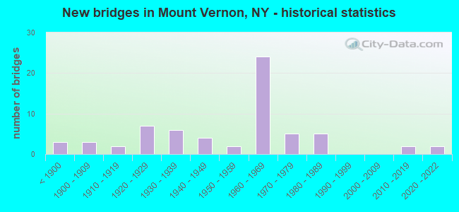
- New bridges - historical statistics
- 3Before 1900
- 31900-1909
- 21910-1919
- 71920-1929
- 61930-1939
- 41940-1949
- 21950-1959
- 241960-1969
- 51970-1979
- 51980-1989
- 22010-2019
- 22020-2022
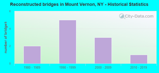
- Reconstructed bridges - Historical Statistics
- 21980-1989
- 51990-1999
- 32000-2009
- 12010-2019
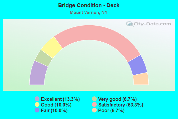
- Bridge Condition - Deck
- 13.3%Excellent
- 6.7%Very good
- 10.0%Good
- 53.3%Satisfactory
- 10.0%Fair
- 6.7%Poor
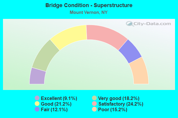
- Bridge Condition - Superstructure
- 9.1%Excellent
- 18.2%Very good
- 21.2%Good
- 24.2%Satisfactory
- 12.1%Fair
- 15.2%Poor
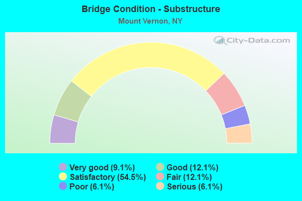
- Bridge Condition - Substructure
- 9.1%Very good
- 12.1%Good
- 54.5%Satisfactory
- 12.1%Fair
- 6.1%Poor
- 6.1%Serious
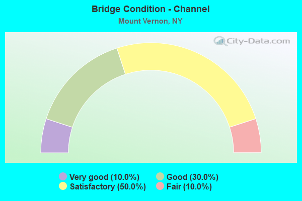
- Bridge Condition - Channel
- 10.0%Very good
- 30.0%Good
- 50.0%Satisfactory
- 10.0%Fair
Find on map >> Show street view
Structure Number: 5016532, Location: 1.0 MI E JCT RTS CCP+BRP (Lat: 40.923064, Lng: -73.822817), Route carried "under" structure: County highway , Year Built: 1967, Structure Length: 0. m, Average Daily Traffic: 10,000 (year 2021), Features Intersected: N.COLUMBUS CR 22, Facility Carried by Structure: RTE 907K
Minimum Vertical Clearance: 4.49m (14.73ft), Kilometerpoint: 0.000, Lanes on structure: 4, Lanes under structure: 5, Material/Design: Steel, Design/Construction: Stringer/Multi-beam, Length of Maximum Span: 29.5m (96.8ft)
Find on map >> Show street view
Structure Number: 5016533, Location: 1.0 MI E JCT RTS CCP+BRP (Lat: 40.923222, Lng: -73.822644), Route carried "under" structure: County highway , Year Built: 1967, Structure Length: 0. m, Average Daily Traffic: 10,000 (year 2021), Features Intersected: N.COLUMBUS CR 22, Facility Carried by Structure: RTE 907K
Minimum Vertical Clearance: 4.52m (14.83ft), Kilometerpoint: 0.000, Lanes on structure: 5, Lanes under structure: 5, Material/Design: Steel, Design/Construction: Stringer/Multi-beam, Length of Maximum Span: 29.5m (96.8ft)
Find on map >> Show street view
Structure Number: 506932, Location: 0.1 MI N JCT RTS CCP+BRP (Lat: 40.928381, Lng: -73.839694), Route carried "under" structure: City street 907G, Year Built: 1974, Structure Length: 0. m, Average Daily Traffic: 6,000 (year 2021), Features Intersected: 907 GX SB, MCQUESTEN PKW, Facility Carried by Structure: RTE 907K
Minimum Vertical Clearance: 7.06m (23.16ft), Kilometerpoint: 0.000, Lanes on structure: 1, Lanes under structure: 3, Material/Design: Steel, Design/Construction: Stringer/Multi-beam, Length of Maximum Span: 36.8m (120.7ft)
Find on map >> Show street view
Structure Number: 55001, Location: 1.7 MI N JCT RTS HRP & 1 (Lat: 40.916297, Lng: -73.811858), Route carried "under" structure: City street 907W, Year Built: 1935, Structure Length: 0. m, Average Daily Traffic: 100 (year 2021), Features Intersected: 907W 907W87011019 SB, RT, Facility Carried by Structure: LINCOLN AVE CR 84
Minimum Vertical Clearance: 4.08m (13.39ft), Kilometerpoint: 0.000, Lanes on structure: 2, Lanes under structure: 3, Material/Design: Concrete, Design/Construction: Frame, Length of Maximum Span: 19.2m (63.0ft)
Find on map >> Show street view
Structure Number: 550010T, Location: 1.7mi north rt 1 hrp (Lat: 40.916186, Lng: -73.811903), Route carried "under" structure: US , Year Built: 2021, Structure Length: 0. m, Features Intersected: Hutchinson River, 907W90, Facility Carried by Structure: Lincoln ave. CR84
Minimum Vertical Clearance: 4.27m (14.01ft), Kilometerpoint: 12.711, Lanes under structure: 4, Material/Design: Steel, Design/Construction: Orthotropic, Length of Maximum Span: 39.3m (128.9ft)
Find on map >> Show street view
Structure Number: 550117, Location: JCT OF RTS CCP & BRP (Lat: 40.927692, Lng: -73.840233), Route carried "under" structure: Other road 907G, Year Built: 1970, Structure Length: 0. m, Average Daily Traffic: 83,162 (year 2015), Features Intersected: 907GX, Midland avenue, 9, Facility Carried by Structure: EB COLL.DIST.907K
Minimum Vertical Clearance: 12.32m (40.42ft), Kilometerpoint: 10.619, Lanes on structure: 2, Lanes under structure: 3, Material/Design: Steel, Design/Construction: Stringer/Multi-beam, Length of Maximum Span: 42.3m (138.8ft)
Find on map >> Show street view
Structure Number: 550117, Location: JCT OF RTS CCP & BRP (Lat: 40.927692, Lng: -73.840233), Route carried "under" structure: City street , Year Built: 1970, Structure Length: 0. m, Average Daily Traffic: 1,000 (year 2021), Features Intersected: 907GX, Midland avenue, 9, Facility Carried by Structure: EB COLL.DIST.907K
Minimum Vertical Clearance: 5.03m (16.50ft), Kilometerpoint: 0.161, Lanes on structure: 2, Lanes under structure: 1, Material/Design: Steel, Design/Construction: Stringer/Multi-beam, Length of Maximum Span: 42.3m (138.8ft)
Find on map >> Show street view
Structure Number: 5501209, Location: JCT OF RTS CCP&BRP (Lat: 40.928000, Lng: -73.840194), Route carried "under" structure: City street , Year Built: 1939, Structure Length: 0. m, Average Daily Traffic: 1,500 (year 2021), Features Intersected: 907GX SB, 907G ramp to 9, Facility Carried by Structure: RTE 907K
Minimum Vertical Clearance: 6.55m (21.49ft), Kilometerpoint: 0.161, Lanes on structure: 3, Lanes under structure: 1, Material/Design: Concrete continuous, Design/Construction: Arch - Deck, Length of Maximum Span: 42.3m (138.8ft)
Find on map >> Show street view
Structure Number: 5501209, Location: JCT OF RTS CCP&BRP (Lat: 40.928000, Lng: -73.840194), Route carried "under" structure: City street 907G, Year Built: 1939, Structure Length: 0. m, Average Daily Traffic: 30,000 (year 2021), Features Intersected: 907GX SB, 907G ramp to 9, Facility Carried by Structure: RTE 907K
Minimum Vertical Clearance: 9.75m (31.99ft), Kilometerpoint: 10.619, Lanes on structure: 3, Lanes under structure: 3, Material/Design: Concrete continuous, Design/Construction: Arch - Deck, Length of Maximum Span: 42.3m (138.8ft)
Find on map >> Show street view
Structure Number: 550121, Location: 0.3 MI E JCT RTS CCP+BRP (Lat: 40.926572, Lng: -73.835442), Route carried "under" structure: State highway 907K, Year Built: 1964, Structure Length: 0. m, Average Daily Traffic: 15,000 (year 2021), Features Intersected: 907KX SB, RTE 907K, Facility Carried by Structure: GRAMATAN AVENUE
Minimum Vertical Clearance: 4.77m (15.65ft), Kilometerpoint: 0.000, Lanes on structure: 2, Lanes under structure: 4, Material/Design: Steel, Design/Construction: Stringer/Multi-beam, Length of Maximum Span: 24.3m (79.7ft)
Find on map >> Show street view
Structure Number: 550122, Location: 0.4 MI E JCT RTS CCP&BRP (Lat: 40.926022, Lng: -73.833119), Route carried "under" structure: City street 907K, Year Built: 1964, Structure Length: 0. m, Average Daily Traffic: 20,000 (year 2021), Features Intersected: 907KX WB, RTE 907K, Facility Carried by Structure: WESTCHESTER AVE
Minimum Vertical Clearance: 5.07m (16.63ft), Kilometerpoint: 0.000, Lanes on structure: 2, Lanes under structure: 4, Material/Design: Steel, Design/Construction: Stringer/Multi-beam, Length of Maximum Span: 20.7m (67.9ft)
Find on map >> Show street view
Structure Number: 550123, Location: 0.6 MI E JCT RTS CCP+BRP (Lat: 40.925536, Lng: -73.828389), Route carried "under" structure: State highway 907K, Year Built: 1964, Structure Length: 0. m, Average Daily Traffic: 20,000 (year 2008), Features Intersected: 907K 907K87012001 SB, RT, Facility Carried by Structure: CENTRAL PARKWAY
Minimum Vertical Clearance: 5.76m (18.90ft), Kilometerpoint: 0.402, Lanes on structure: 2, Lanes under structure: 3, Material/Design: Steel, Design/Construction: Stringer/Multi-beam, Length of Maximum Span: 20.4m (66.9ft)
Find on map >> Show street view
Structure Number: 5501251, Location: 1.4 MI S JCT RTS CCP+HRP (Lat: 40.922431, Lng: -73.817956), Route carried "under" structure: City street , Year Built: 1967, Structure Length: 0. m, Average Daily Traffic: 1,091 (year 2020), Truck Traffic: 1%, Features Intersected: SHERIDAN AVE, Facility Carried by Structure: WARTBURG C0NN WB
Minimum Vertical Clearance: 4.57m (14.99ft), Kilometerpoint: 0.515, Lanes on structure: 2, Lanes under structure: 2, Material/Design: Steel, Design/Construction: Stringer/Multi-beam, Length of Maximum Span: 21.3m (69.9ft)
Find on map >> Show street view
Structure Number: 5501252, Location: 1.4 MI S JCT RTS CCP&HRP (Lat: 40.922292, Lng: -73.817986), Route carried "under" structure: City street , Year Built: 1967, Structure Length: 0. m, Average Daily Traffic: 1,091 (year 2020), Truck Traffic: 1%, Features Intersected: SHERIDAN AVE, Facility Carried by Structure: RTE 907K
Minimum Vertical Clearance: 6.19m (20.31ft), Kilometerpoint: 0.499, Lanes on structure: 3, Lanes under structure: 2, Material/Design: Steel, Design/Construction: Stringer/Multi-beam, Length of Maximum Span: 21.0m (68.9ft)
Find on map >> Show street view
Structure Number: 5501253, Location: 1.4 MI S JCT CCP&HRP (Lat: 40.922158, Lng: -73.818019), Route carried "under" structure: City street , Year Built: 1967, Structure Length: 0. m, Average Daily Traffic: 2,182 (year 2020), Truck Traffic: 1%, Features Intersected: SHERIDAN AVE, Facility Carried by Structure: RTE 907K
Minimum Vertical Clearance: 4.54m (14.90ft), Kilometerpoint: 0.257, Lanes on structure: 4, Lanes under structure: 2, Material/Design: Steel, Design/Construction: Stringer/Multi-beam, Length of Maximum Span: 20.7m (67.9ft)
Find on map >> Show street view
Structure Number: 5501261, Location: 1.3 MI S JCT RTS CCP+HRP (Lat: 40.922756, Lng: -73.816178), Route carried "under" structure: Other road , Year Built: 1967, Structure Length: 0. m, Average Daily Traffic: 10,000 (year 2021), Features Intersected: WARTBURG CONN WB, Facility Carried by Structure: RTE 907K
Minimum Vertical Clearance: 4.49m (14.73ft), Kilometerpoint: 0.000, Lanes on structure: 3, Lanes under structure: 2, Material/Design: Steel, Design/Construction: Stringer/Multi-beam, Length of Maximum Span: 28.6m (93.8ft)
Find on map >> Show street view
Structure Number: 5501262, Location: 1.3 MI S JCT RTS CCP&HRP (Lat: 40.922733, Lng: -73.815883), Route carried "under" structure: Other road , Year Built: 1967, Structure Length: 0. m, Average Daily Traffic: 8,000 (year 2021), Features Intersected: WARTBURG CONN WB, Facility Carried by Structure: RTE 907K
Minimum Vertical Clearance: 5.79m (19.00ft), Kilometerpoint: 0.000, Lanes on structure: 3, Lanes under structure: 2, Material/Design: Steel, Design/Construction: Stringer/Multi-beam, Length of Maximum Span: 21.0m (68.9ft)
Find on map >> Show street view
Structure Number: 550127, Location: 1.1 MI S JCT RTS CCP+HRP (Lat: 40.925961, Lng: -73.813292), Route carried "under" structure: City street 907K, Year Built: 1966, Structure Length: 0. m, Average Daily Traffic: 20,880 (year 2021), Features Intersected: 907K 907K87012016, RTE 9, Facility Carried by Structure: ACCESS TO SCHOOL
Minimum Vertical Clearance: 4.59m (15.06ft), Kilometerpoint: 6.597, Lanes under structure: 3, Material/Design: Steel, Design/Construction: Girder and Floorbeam System, Length of Maximum Span: 17.1m (56.1ft)
Find on map >> Show street view
Structure Number: 550127, Location: 1.1 MI S JCT RTS CCP+HRP (Lat: 40.925961, Lng: -73.813292), Route carried "under" structure: City street , Year Built: 1966, Structure Length: 0. m, Features Intersected: 907K 907K87012016, RTE 9, Facility Carried by Structure: ACCESS TO SCHOOL
Minimum Vertical Clearance: 4.60m (15.09ft), Kilometerpoint: 6.597, Lanes under structure: 3, Material/Design: Steel, Design/Construction: Girder and Floorbeam System, Length of Maximum Span: 17.1m (56.1ft)
Find on map >> Show street view
Structure Number: 5521619, Location: 1.0 MI NW OF PELHAM (Lat: 40.921558, Lng: -73.810808), Route carried "under" structure: City street , Year Built: 1947, Structure Length: 0. m, Features Intersected: HUTCHINSON BLVD., Facility Carried by Structure: RTE 907K
Minimum Vertical Clearance: 5.41m (17.75ft), Kilometerpoint: 0.000, Lanes on structure: 3, Lanes under structure: 2, Material/Design: Concrete, Design/Construction: Arch - Deck, Length of Maximum Span: 15.5m (50.9ft)
Find on map >> Show street view
Structure Number: 701652, Location: JCT RR&RTE 22 MT VERNON (Lat: 40.911997, Lng: -73.822942), Route carried "under" structure: State highway , Year Built: 1930, Structure Length: 0. m, Average Daily Traffic: 9,700 (year 1972), Features Intersected: Rt 22,COLUMBUS AV, Facility Carried by Structure: MNRR NH LINE
Minimum Vertical Clearance: 3.81m (12.50ft), Kilometerpoint: 12.454, Lanes under structure: 4, Material/Design: Steel, Design/Construction: Stringer/Multi-beam, Length of Maximum Span: 15.8m (51.8ft)
Find on map >> Show street view
Structure Number: 750007, Location: 1.3 MI N JCT RTS HRP < 1 (Lat: 40.911156, Lng: -73.813883), Route carried "under" structure: City street 907W, Year Built: 1926, Structure Length: 0. m, Average Daily Traffic: 91,781 (year 2002), Features Intersected: RTE 907W, Facility Carried by Structure: MNRR NH LINE
Minimum Vertical Clearance: 10.66m (34.97ft), Kilometerpoint: 0.193, Lanes under structure: 4, Material/Design: Concrete, Design/Construction: Arch - Deck, Length of Maximum Span: 21.9m (71.9ft)
Find on map >> Show street view
Structure Number: 771285, Location: 0.5 MI NW OF PELHAM (Lat: 40.911953, Lng: -73.817508), Route carried "under" structure: City street , Year Built: 1900, Structure Length: 0. m, Average Daily Traffic: 3,927 (year 2020), Truck Traffic: 4%, Features Intersected: BRADFORD AVENUE, Facility Carried by Structure: MNRR NH LINE
Minimum Vertical Clearance: 3.83m (12.57ft), Kilometerpoint: 0.000, Lanes under structure: 2, Material/Design: Steel, Design/Construction: Girder and Floorbeam System, Length of Maximum Span: 15.8m (51.8ft)
Find on map >> Show street view
Structure Number: 7713, Location: 2.2 MI W.OF N PELHAM (Lat: 40.913550, Lng: -73.849967), Route carried "under" structure: County highway , Year Built: 1920, Structure Length: 0. m, Average Daily Traffic: 100 (year 2021), Features Intersected: MT VRNON AV-CR66A, Facility Carried by Structure: MNRR HA LINE
Minimum Vertical Clearance: 4.26m (13.98ft), Kilometerpoint: 0.000, Lanes under structure: 2, Material/Design: Steel continuous, Design/Construction: Girder and Floorbeam System, Length of Maximum Span: 12.8m (42.0ft)
Find on map >> Show street view
Structure Number: 771301, Location: 2.2 MI W OF N PELHAM. (Lat: 40.913483, Lng: -73.849861), Route carried "under" structure: County highway , Year Built: 1920, Structure Length: 0. m, Average Daily Traffic: 100 (year 2021), Features Intersected: MT VRNON AV-CR66A, Facility Carried by Structure: MNRR HA LINE
Minimum Vertical Clearance: 4.41m (14.47ft), Kilometerpoint: 0.000, Lanes under structure: 2, Material/Design: Steel continuous, Design/Construction: Girder and Floorbeam System, Length of Maximum Span: 12.8m (42.0ft)
Find on map >> Show street view
Structure Number: 771302, Location: 2.2 MI W OF N PELHAM. (Lat: 40.913431, Lng: -73.849789), Route carried "under" structure: County highway , Year Built: 1920, Structure Length: 0. m, Average Daily Traffic: 10,000 (year 2021), Features Intersected: MT VRNON AV-CR66A, Facility Carried by Structure: MNRR HA LINE
Minimum Vertical Clearance: 4.26m (13.98ft), Kilometerpoint: 0.000, Lanes under structure: 2, Material/Design: Steel continuous, Design/Construction: Girder and Floorbeam System, Length of Maximum Span: 12.8m (42.0ft)