Bridge Statistics for Murray, Utah (UT)
Condition, Traffic, Stress, Structural Evaluation, Project Costs
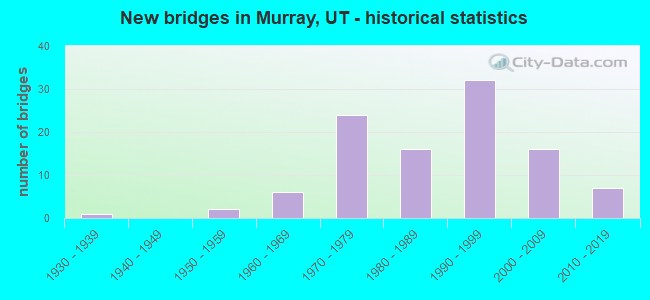
- New bridges - historical statistics
- 11930-1939
- 21950-1959
- 61960-1969
- 241970-1979
- 161980-1989
- 321990-1999
- 162000-2009
- 72010-2019
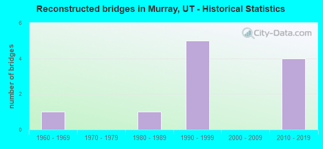
- Reconstructed bridges - Historical Statistics
- 11960-1969
- 01970-1979
- 11980-1989
- 51990-1999
- 02000-2009
- 42010-2019
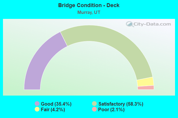
- Bridge Condition - Deck
- 35.4%Good
- 58.3%Satisfactory
- 4.2%Fair
- 2.1%Poor
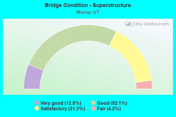
- Bridge Condition - Superstructure
- 12.5%Very good
- 52.1%Good
- 31.3%Satisfactory
- 4.2%Fair
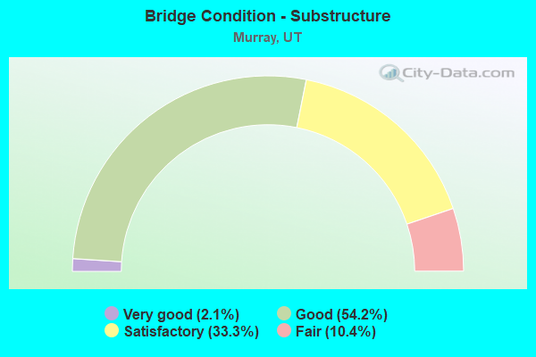
- Bridge Condition - Substructure
- 2.1%Very good
- 54.2%Good
- 33.3%Satisfactory
- 10.4%Fair
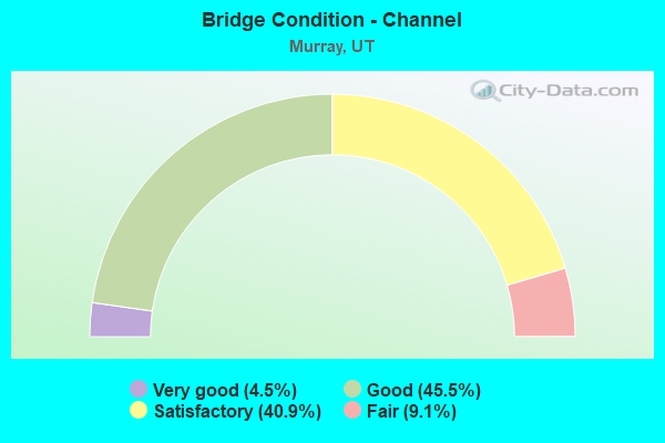
- Bridge Condition - Channel
- 4.5%Very good
- 45.5%Good
- 40.9%Satisfactory
- 9.1%Fair
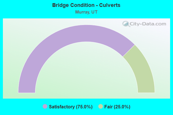
- Bridge Condition - Culverts
- 75.0%Satisfactory
- 25.0%Fair
Find on map >> Show street view
Structure Number: 1F 664, Location: 400 W.6400 SO.IN MURRAY (Lat: 40.631014, Lng: -111.902211), Route carried "on" structure: Ramp Interstate 15, Year Built: 1998, Status: Open, Structure Length: 19.07m (62.57ft), Average Daily Traffic: 23,546 (year 2020), Truck Traffic: 25%, Average Future Daily Traffic: 29,433 (year 2040), Design Load: HS 25 or greater, Features Intersected: LT.RAIL SPUR & 6400 S.ST
Minimum Vertical Clearance: 30+ m (98+ ft), Kilometerpoint: 0.104, Lanes on structure: 2, Lanes under structure: 2, Owner: State Highway Agency, Approaching Roadway Width: 12.0m (39.4ft), Skew: 30 degrees, Material/Design: Prestressed concrete, Design/Construction: Stringer/Multi-beam, Number Of Spans In Main Unit: 5, Length of Maximum Span: 41.4m (135.8ft), Curb-To-Curb Width: 12.0m (39.4ft), Out-to-Out Width: 12.9m (42.3ft)
Condition: Deck: Good, Superstructure: Good, Substructure: Good, Operating Rating: 34.7 metric tons, Method Used To Determine Operating Rating: Load and Resistance Factor Rating (LRFR) rating reported by rating factor(RF) method using HL-93 loadings, Inventory Rating: 15.6 metric tons, Method Used To Determine Inventory Rating: Load Factor (LF) rating reported by rating factor (RF) method using MS18 loading, Structural Evaluation: High priority of corrective action, Deck Geometry: Superior to present desirable criteria, Underclear: Meets minimum limits, Approach Roadway Alignment: Equal to present desirable criteria, Designated Inspection Frequency: Every 24 months, Inspection Date: October 2020, Deck Structure Type: Concrete Precast Panels, Wearing Surface/Protective System: Wearing Surface: Epoxy Overlay, Deck Protection: Epoxy Coated Reinforcing
Find on map >> Show street view
Structure Number: 2C 554, Location: 6400 SOUTH INTERCHANGE (Lat: 40.636550, Lng: -111.906958), Route carried "on" structure: Ramp Interstate 15, Year Built: 1973, Status: Open, Structure Length: 4.74m (15.55ft), Average Daily Traffic: 23,546 (year 2020), Truck Traffic: 25%, Average Future Daily Traffic: 29,433 (year 2040), Design Load: HS 20+Mod, Features Intersected: I-215 (SR-215) WBL
Minimum Vertical Clearance: 30.18m (99.02ft), Kilometerpoint: 0.237, Lanes on structure: 2, Lanes under structure: 5, Owner: State Highway Agency, Approaching Roadway Width: 11.7m (38.4ft), Material/Design: Steel continuous, Design/Construction: Stringer/Multi-beam, Number Of Spans In Main Unit: 3, Length of Maximum Span: 21.1m (69.2ft), Curb-To-Curb Width: 11.7m (38.4ft), Out-to-Out Width: 12.8m (42.0ft)
Condition: Deck: Satisfactory, Superstructure: Satisfactory, Substructure: Satisfactory, Operating Rating: 55.7 metric tons, Method Used To Determine Operating Rating: Load and Resistance Factor Rating (LRFR) rating reported by rating factor(RF) method using HL-93 loadings, Inventory Rating: 35.3 metric tons, Method Used To Determine Inventory Rating: Load and Resistance Factor Rating (LRFR) rating reported by rating factor(RF) method using HL-93 loadings, Structural Evaluation: Equal to present minimum criteria, Deck Geometry: Superior to present desirable criteria, Underclear: High priority of corrective action, Approach Roadway Alignment: Equal to present minimum criteria, Designated Inspection Frequency: Every 24 months, Inspection Date: October 2020, Deck Structure Type: Concrete Cast-file-Place, Wearing Surface/Protective System: Wearing Surface: Bituminous, Membrane: Preformed Fabric
Find on map >> Show street view
Structure Number: 2F 133, Location: 1100 WEST 6200 SO. SL CO. (Lat: 40.638831, Lng: -111.922392), Route carried "on" structure: Interstate 215, Year Built: 1971, Year Reconstructed: 2003, Status: Open, Structure Length: 3.96m (12.99ft), Average Daily Traffic: 91,598 (year 2020), Truck Traffic: 16%, Average Future Daily Traffic: 114,498 (year 2040), Design Load: HS 20+Mod, Features Intersected: JORDAN RIVER
Minimum Vertical Clearance: 30.18m (99.02ft), Kilometerpoint: 20.169, Lanes on structure: 4, Base Highway Network: Yes, Owner: State Highway Agency, Approaching Roadway Width: 23.0m (75.5ft), Skew: 34 degrees, Material/Design: Prestressed concrete, Design/Construction: Stringer/Multi-beam, Number Of Spans In Main Unit: 2, Length of Maximum Span: 18.9m (62.0ft), Curb-To-Curb Width: 23.2m (76.1ft), Out-to-Out Width: 24.1m (79.1ft)
Condition: Deck: Good, Superstructure: Good, Substructure: Satisfactory, Channel: Good, Operating Rating: 37.6 metric tons, Method Used To Determine Operating Rating: Load and Resistance Factor Rating (LRFR) rating reported by rating factor(RF) method using HL-93 loadings, Inventory Rating: 31.4 metric tons, Method Used To Determine Inventory Rating: Load Factor (LF) rating reported by rating factor (RF) method using MS18 loading, Structural Evaluation: Equal to present minimum criteria, Deck Geometry: Superior to present desirable criteria, Waterway Adequacy: Equal to present desirable criteria, Approach Roadway Alignment: Equal to present desirable criteria, Designated Inspection Frequency: Every 24 months, Underwater Inspection Frequency: Every 60 months, Inspection Date: October 2020, Underwater Inspection Date: July 2019, Deck Structure Type: Concrete Cast-file-Place, Wearing Surface/Protective System: Wearing Surface: Bituminous, Membrane: Preformed Fabric
Find on map >> Show street view
Structure Number: 3C 829S, Location: 0.2 MI.SO.6400 SOUTH ST. (Lat: 40.630514, Lng: -111.903797), Route carried "on" structure: Interstate 15, Year Built: 1999, Year Reconstructed: 2019, Status: Open, Structure Length: 19.99m (65.58ft), Average Daily Traffic: 236,512 (year 2020), Truck Traffic: 19%, Average Future Daily Traffic: 295,640 (year 2040), Design Load: HS 25 or greater, Features Intersected: UNION PACIFIC RAILROAD
Minimum Vertical Clearance: 30+ m (98+ ft), Kilometerpoint: 481.123, Lanes on structure: 7, Base Highway Network: Yes, Owner: State Highway Agency, Approaching Roadway Width: 31.8m (104.3ft), Skew: 3 degrees, Material/Design: Steel continuous, Design/Construction: Stringer/Multi-beam, Number Of Spans In Main Unit: 3, Length of Maximum Span: 81.9m (268.7ft), Curb-To-Curb Width: 31.8m (104.3ft), Out-to-Out Width: 32.7m (107.3ft)
Condition: Deck: Good, Superstructure: Very good, Substructure: Good, Operating Rating: 71.6 metric tons, Method Used To Determine Operating Rating: Load and Resistance Factor Rating (LRFR) rating reported by rating factor(RF) method using HL-93 loadings, Inventory Rating: 53.1 metric tons, Method Used To Determine Inventory Rating: Load and Resistance Factor Rating (LRFR) rating reported by rating factor(RF) method using HL-93 loadings, Structural Evaluation: Better than present minimum criteria, Deck Geometry: Equal to present minimum criteria, Underclear: Superior to present desirable criteria, Approach Roadway Alignment: Equal to present desirable criteria, Designated Inspection Frequency: Every 24 months, Inspection Date: October 2020, Deck Structure Type: Concrete Cast-file-Place, Wearing Surface/Protective System: Wearing Surface: Epoxy Overlay, Membrane: Epoxy, Deck Protection: Epoxy Coated Reinforcing
Find on map >> Show street view
Structure Number: 3C 832S, Location: 6400 SOUTH INTERCHANGE (Lat: 40.635208, Lng: -111.905144), Route carried "on" structure: Interstate 15, Year Built: 1999, Status: Open, Structure Length: 4.80m (15.75ft), Average Daily Traffic: 236,512 (year 2020), Truck Traffic: 19%, Average Future Daily Traffic: 295,640 (year 2040), Design Load: HS 25 or greater, Features Intersected: I-215EB & RAMP to I-
Minimum Vertical Clearance: 30.18m (99.02ft), Kilometerpoint: 481.468, Lanes on structure: 5, Lanes under structure: 6, Base Highway Network: Yes, Owner: State Highway Agency, Approaching Roadway Width: 25.1m (82.3ft), Material/Design: Steel, Design/Construction: Stringer/Multi-beam, Number Of Spans In Main Unit: 1, Length of Maximum Span: 47.1m (154.5ft), Curb-To-Curb Width: 25.1m (82.3ft), Out-to-Out Width: 25.6m (84.0ft)
Condition: Deck: Good, Superstructure: Good, Substructure: Good, Operating Rating: 81.6 metric tons, Method Used To Determine Operating Rating: Load and Resistance Factor Rating (LRFR) rating reported by rating factor(RF) method using HL-93 loadings, Inventory Rating: 43.4 metric tons, Method Used To Determine Inventory Rating: Load and Resistance Factor Rating (LRFR) rating reported by rating factor(RF) method using HL-93 loadings, Structural Evaluation: Better than present minimum criteria, Deck Geometry: Better than present minimum criteria, Underclear: Equal to present minimum criteria, Approach Roadway Alignment: Equal to present desirable criteria, Designated Inspection Frequency: Every 24 months, Inspection Date: October 2020, Deck Structure Type: Concrete Cast-file-Place, Wearing Surface/Protective System: Wearing Surface: Latex Concrete, Deck Protection: Epoxy Coated Reinforcing
Find on map >> Show street view
Structure Number: 3C 834, Location: 6400 SOUTH INTERCHANGE (Lat: 40.635250, Lng: -111.905411), Route carried "on" structure: Ramp Interstate 15, Year Built: 1999, Status: Open, Structure Length: 4.85m (15.91ft), Average Daily Traffic: 23,546 (year 2020), Truck Traffic: 25%, Average Future Daily Traffic: 29,433 (year 2040), Design Load: HS 25 or greater, Features Intersected: I-215EB & RAMP to I-
Minimum Vertical Clearance: 30.18m (99.02ft), Kilometerpoint: 0.831, Lanes on structure: 2, Lanes under structure: 6, Owner: State Highway Agency, Approaching Roadway Width: 10.8m (35.4ft), Skew: 1 degrees, Material/Design: Steel, Design/Construction: Stringer/Multi-beam, Number Of Spans In Main Unit: 1, Length of Maximum Span: 47.6m (156.2ft), Curb-To-Curb Width: 12.0m (39.4ft), Out-to-Out Width: 12.9m (42.3ft)
Condition: Deck: Good, Superstructure: Very good, Substructure: Good, Operating Rating: 70.0 metric tons, Method Used To Determine Operating Rating: Load and Resistance Factor Rating (LRFR) rating reported by rating factor(RF) method using HL-93 loadings, Inventory Rating: 43.7 metric tons, Method Used To Determine Inventory Rating: Load Factor (LF) rating reported by rating factor (RF) method using MS18 loading, Structural Evaluation: Better than present minimum criteria, Deck Geometry: Superior to present desirable criteria, Underclear: Equal to present minimum criteria, Approach Roadway Alignment: Equal to present minimum criteria, Designated Inspection Frequency: Every 24 months, Inspection Date: October 2020, Deck Structure Type: Concrete Cast-file-Place, Wearing Surface/Protective System: Wearing Surface: Latex Concrete, Deck Protection: Epoxy Coated Reinforcing
Find on map >> Show street view
Structure Number: 3C 835, Location: 6400 SOUTH INTERCHANGE (Lat: 40.636606, Lng: -111.905142), Route carried "on" structure: Ramp Interstate 15, Year Built: 1999, Status: Open, Structure Length: 6.35m (20.83ft), Average Daily Traffic: 23,546 (year 2020), Truck Traffic: 25%, Average Future Daily Traffic: 29,433 (year 2040), Design Load: HS 25 or greater, Features Intersected: I-215 WB RAMP to I-15 SB
Minimum Vertical Clearance: 30+ m (98+ ft), Kilometerpoint: 0.679, Lanes on structure: 2, Lanes under structure: 7, Owner: State Highway Agency, Approaching Roadway Width: 10.8m (35.4ft), Material/Design: Steel, Design/Construction: Stringer/Multi-beam, Number Of Spans In Main Unit: 1, Length of Maximum Span: 62.6m (205.4ft), Curb-To-Curb Width: 12.0m (39.4ft), Out-to-Out Width: 12.9m (42.3ft)
Condition: Deck: Satisfactory, Superstructure: Good, Substructure: Good, Operating Rating: 46.7 metric tons, Method Used To Determine Operating Rating: Load and Resistance Factor Rating (LRFR) rating reported by rating factor(RF) method using HL-93 loadings, Inventory Rating: 37.6 metric tons, Method Used To Determine Inventory Rating: Load Factor (LF) rating reported by rating factor (RF) method using MS18 loading, Structural Evaluation: Better than present minimum criteria, Deck Geometry: Superior to present desirable criteria, Underclear: High priority of corrective action, Approach Roadway Alignment: Equal to present minimum criteria, Designated Inspection Frequency: Every 24 months, Inspection Date: October 2020, Deck Structure Type: Concrete Cast-file-Place, Wearing Surface/Protective System: Wearing Surface: Latex Concrete, Deck Protection: Epoxy Coated Reinforcing
Find on map >> Show street view
Structure Number: 3C 836S, Location: 500 WEST 5900 SO.,MURRAY (Lat: 40.643158, Lng: -111.903039), Route carried "on" structure: Interstate 15, Year Built: 1999, Status: Open, Structure Length: 3.64m (11.94ft), Average Daily Traffic: 176,880 (year 2020), Truck Traffic: 15%, Average Future Daily Traffic: 221,100 (year 2040), Design Load: HS 25 or greater, Features Intersected: 5900 SOUTH STREET
Minimum Vertical Clearance: 30+ m (98+ ft), Kilometerpoint: 482.373, Lanes on structure: 6, Lanes under structure: 2, Base Highway Network: Yes, Owner: State Highway Agency, Approaching Roadway Width: 28.4m (93.2ft), Material/Design: Steel, Design/Construction: Stringer/Multi-beam, Number Of Spans In Main Unit: 1, Length of Maximum Span: 35.3m (115.8ft), Curb-To-Curb Width: 28.7m (94.2ft), Out-to-Out Width: 29.5m (96.8ft)
Condition: Deck: Satisfactory, Superstructure: Good, Substructure: Satisfactory, Operating Rating: 73.5 metric tons, Method Used To Determine Operating Rating: Load and Resistance Factor Rating (LRFR) rating reported by rating factor(RF) method using HL-93 loadings, Inventory Rating: 47.0 metric tons, Method Used To Determine Inventory Rating: Load Factor (LF) rating reported by rating factor (RF) method using MS18 loading, Structural Evaluation: Equal to present minimum criteria, Deck Geometry: Better than present minimum criteria, Underclear: Superior to present desirable criteria, Approach Roadway Alignment: Equal to present desirable criteria, Designated Inspection Frequency: Every 24 months, Inspection Date: October 2020, Deck Structure Type: Concrete Cast-file-Place, Wearing Surface/Protective System: Wearing Surface: Latex Concrete, Deck Protection: Epoxy Coated Reinforcing
Find on map >> Show street view
Structure Number: 3F 611S, Location: 0.1 Mi.SO.OF 6400 SO.ST. (Lat: 40.631056, Lng: -111.904381), Route carried "on" structure: Interstate 15, Year Built: 1999, Year Reconstructed: 2019, Status: Open, Structure Length: 6.89m (22.60ft), Average Daily Traffic: 236,512 (year 2020), Truck Traffic: 19%, Average Future Daily Traffic: 295,640 (year 2040), Design Load: HS 25 or greater, Features Intersected: UTA,LIGHT RAIL SPUR LINE
Minimum Vertical Clearance: 30.18m (99.02ft), Kilometerpoint: 480.998, Lanes on structure: 7, Base Highway Network: Yes, Owner: State Highway Agency, Approaching Roadway Width: 31.9m (104.7ft), Skew: 3 degrees, Material/Design: Prestressed concrete, Design/Construction: Stringer/Multi-beam, Number Of Spans In Main Unit: 1, Length of Maximum Span: 65.5m (214.9ft), Curb-To-Curb Width: 31.9m (104.7ft), Out-to-Out Width: 32.7m (107.3ft)
Condition: Deck: Good, Superstructure: Good, Substructure: Good, Operating Rating: 32.7 metric tons, Method Used To Determine Operating Rating: Load and Resistance Factor Rating (LRFR) rating reported by rating factor(RF) method using HL-93 loadings, Inventory Rating: 22.4 metric tons, Method Used To Determine Inventory Rating: Load and Resistance Factor Rating (LRFR) rating reported by rating factor(RF) method using HL-93 loadings, Structural Evaluation: Somewhat better than minimum adequacy, Deck Geometry: Equal to present minimum criteria, Underclear: Superior to present desirable criteria, Approach Roadway Alignment: Equal to present desirable criteria, Designated Inspection Frequency: Every 24 months, Inspection Date: October 2020, Deck Structure Type: Concrete Cast-file-Place, Wearing Surface/Protective System: Wearing Surface: Epoxy Overlay, Deck Protection: Epoxy Coated Reinforcing
Find on map >> Show street view
Structure Number: 3F 612, Location: 0.1 MI.SO.6400 SOUTH ST. (Lat: 40.630889, Lng: -111.904575), Route carried "on" structure: Ramp Interstate 15, Year Built: 1998, Year Reconstructed: 2019, Status: Open, Structure Length: 6.70m (21.98ft), Average Daily Traffic: 23,546 (year 2020), Truck Traffic: 25%, Average Future Daily Traffic: 29,433 (year 2040), Design Load: HS 25 or greater, Features Intersected: UTA,LIGHT RAIL SPUR LINE
Minimum Vertical Clearance: 30+ m (98+ ft), Kilometerpoint: 0.153, Lanes on structure: 2, Owner: State Highway Agency, Approaching Roadway Width: 12.6m (41.3ft), Skew: 2 degrees, Material/Design: Prestressed concrete continuous, Design/Construction: Stringer/Multi-beam, Number Of Spans In Main Unit: 3, Length of Maximum Span: 35.0m (114.8ft), Curb-To-Curb Width: 17.8m (58.4ft), Out-to-Out Width: 18.7m (61.4ft)
Condition: Deck: Good, Superstructure: Satisfactory, Substructure: Good, Operating Rating: 60.3 metric tons, Method Used To Determine Operating Rating: Load and Resistance Factor Rating (LRFR) rating reported by rating factor(RF) method using HL-93 loadings, Inventory Rating: 45.0 metric tons, Method Used To Determine Inventory Rating: Load Factor (LF) rating reported by rating factor (RF) method using MS18 loading, Structural Evaluation: Equal to present minimum criteria, Deck Geometry: Superior to present desirable criteria, Underclear: Superior to present desirable criteria, Approach Roadway Alignment: Equal to present desirable criteria, Designated Inspection Frequency: Every 24 months, Inspection Date: October 2020, Deck Structure Type: Concrete Precast Panels, Wearing Surface/Protective System: Wearing Surface: Integral Concrete, Deck Protection: Epoxy Coated Reinforcing
Find on map >> Show street view
Structure Number: 3F 613S, Location: 500 WEST 6400 SO.-MURRAY (Lat: 40.632575, Lng: -111.904942), Route carried "on" structure: Interstate 15, Year Built: 1999, Status: Open, Structure Length: 5.99m (19.65ft), Average Daily Traffic: 236,512 (year 2020), Truck Traffic: 19%, Average Future Daily Traffic: 295,640 (year 2040), Design Load: HS 25 or greater, Features Intersected: 6400 SOUTH STREET
Minimum Vertical Clearance: 30+ m (98+ ft), Kilometerpoint: 481.174, Lanes on structure: 5, Lanes under structure: 4, Base Highway Network: Yes, Owner: State Highway Agency, Approaching Roadway Width: 24.8m (81.4ft), Material/Design: Prestressed concrete, Design/Construction: Stringer/Multi-beam, Number Of Spans In Main Unit: 3, Length of Maximum Span: 35.8m (117.5ft), Curb-To-Curb Width: 25.1m (82.3ft), Out-to-Out Width: 25.9m (85.0ft)
Condition: Deck: Good, Superstructure: Good, Substructure: Good, Operating Rating: 43.1 metric tons, Method Used To Determine Operating Rating: Load and Resistance Factor Rating (LRFR) rating reported by rating factor(RF) method using HL-93 loadings, Inventory Rating: 29.8 metric tons, Method Used To Determine Inventory Rating: Load and Resistance Factor Rating (LRFR) rating reported by rating factor(RF) method using HL-93 loadings, Structural Evaluation: Better than present minimum criteria, Deck Geometry: Better than present minimum criteria, Underclear: Equal to present minimum criteria, Approach Roadway Alignment: Equal to present desirable criteria, Designated Inspection Frequency: Every 24 months, Inspection Date: October 2020, Deck Structure Type: Concrete Cast-file-Place, Wearing Surface/Protective System: Wearing Surface: Epoxy Overlay, Deck Protection: Epoxy Coated Reinforcing
Find on map >> Show street view
Structure Number: 3F 614, Location: 500 WEST 6400 SO.-MURRAY (Lat: 40.632528, Lng: -111.905217), Route carried "on" structure: Ramp Interstate 15, Year Built: 1998, Year Reconstructed: 2019, Status: Open, Structure Length: 5.57m (18.27ft), Average Daily Traffic: 23,546 (year 2020), Truck Traffic: 25%, Average Future Daily Traffic: 29,433 (year 2040), Design Load: HS 25 or greater, Features Intersected: WINCHESTER AVE.
Minimum Vertical Clearance: 30.18m (99.02ft), Kilometerpoint: 0.517, Lanes on structure: 2, Lanes under structure: 4, Owner: State Highway Agency, Approaching Roadway Width: 13.4m (44.0ft), Material/Design: Prestressed concrete continuous, Design/Construction: Stringer/Multi-beam, Number Of Spans In Main Unit: 3, Length of Maximum Span: 25.9m (85.0ft), Curb-To-Curb Width: 13.4m (44.0ft), Out-to-Out Width: 14.0m (45.9ft)
Condition: Deck: Good, Superstructure: Good, Substructure: Good, Operating Rating: 53.1 metric tons, Method Used To Determine Operating Rating: Load and Resistance Factor Rating (LRFR) rating reported by rating factor(RF) method using HL-93 loadings, Inventory Rating: 40.5 metric tons, Method Used To Determine Inventory Rating: Load Factor (LF) rating reported by rating factor (RF) method using MS18 loading, Structural Evaluation: Better than present minimum criteria, Deck Geometry: Superior to present desirable criteria, Underclear: Superior to present desirable criteria, Approach Roadway Alignment: Equal to present desirable criteria, Designated Inspection Frequency: Every 24 months, Inspection Date: October 2020, Deck Structure Type: Concrete Precast Panels, Wearing Surface/Protective System: Wearing Surface: Integral Concrete, Membrane: Epoxy, Deck Protection: Epoxy Coated Reinforcing
Find on map >> Show street view
Structure Number: 3F 615S, Location: 6400 SOUTH INTERCHANGE (Lat: 40.636597, Lng: -111.904875), Route carried "on" structure: Interstate 15, Year Built: 1999, Status: Open, Structure Length: 6.50m (21.33ft), Average Daily Traffic: 176,880 (year 2020), Truck Traffic: 15%, Average Future Daily Traffic: 221,100 (year 2040), Design Load: HS 25 or greater, Features Intersected: I-215WB and RAMP TO I-
Minimum Vertical Clearance: 30.18m (99.02ft), Kilometerpoint: 481.624, Lanes on structure: 5, Lanes under structure: 7, Base Highway Network: Yes, Owner: State Highway Agency, Approaching Roadway Width: 25.1m (82.3ft), Material/Design: Prestressed concrete, Design/Construction: Stringer/Multi-beam, Number Of Spans In Main Unit: 1, Length of Maximum Span: 62.0m (203.4ft), Curb-To-Curb Width: 25.1m (82.3ft), Out-to-Out Width: 25.9m (85.0ft)
Condition: Deck: Good, Superstructure: Satisfactory, Substructure: Good, Operating Rating: 54.4 metric tons, Method Used To Determine Operating Rating: Load and Resistance Factor Rating (LRFR) rating reported by rating factor(RF) method using HL-93 loadings, Inventory Rating: 41.5 metric tons, Method Used To Determine Inventory Rating: Load and Resistance Factor Rating (LRFR) rating reported by rating factor(RF) method using HL-93 loadings, Structural Evaluation: Equal to present minimum criteria, Deck Geometry: Better than present minimum criteria, Underclear: Meets minimum limits, Approach Roadway Alignment: Equal to present desirable criteria, Designated Inspection Frequency: Every 24 months, Inspection Date: October 2020, Deck Structure Type: Concrete Cast-file-Place, Wearing Surface/Protective System: Wearing Surface: Latex Concrete, Deck Protection: Epoxy Coated Reinforcing
Find on map >> Show street view
Structure Number: 3F 616S, Location: 5300 SOUTH INTERCHANGE (Lat: 40.655114, Lng: -111.901864), Route carried "on" structure: Interstate 15, Year Built: 1999, Status: Open, Structure Length: 7.04m (23.10ft), Average Daily Traffic: 176,880 (year 2020), Truck Traffic: 15%, Average Future Daily Traffic: 221,100 (year 2040), Design Load: HS 25 or greater, Features Intersected: SR-173,5300 SO.INT.X-RD.
Minimum Vertical Clearance: 30+ m (98+ ft), Kilometerpoint: 483.704, Lanes on structure: 5, Lanes under structure: 7, Base Highway Network: Yes, Owner: State Highway Agency, Approaching Roadway Width: 25.1m (82.3ft), Skew: 31 degrees, Material/Design: Prestressed concrete, Design/Construction: Stringer/Multi-beam, Number Of Spans In Main Unit: 1, Length of Maximum Span: 67.4m (221.1ft), Curb-To-Curb Width: 25.1m (82.3ft), Out-to-Out Width: 25.9m (85.0ft)
Condition: Deck: Good, Superstructure: Good, Substructure: Good, Operating Rating: 66.4 metric tons, Method Used To Determine Operating Rating: Load and Resistance Factor Rating (LRFR) rating reported by rating factor(RF) method using HL-93 loadings, Inventory Rating: 48.9 metric tons, Method Used To Determine Inventory Rating: Load and Resistance Factor Rating (LRFR) rating reported by rating factor(RF) method using HL-93 loadings, Structural Evaluation: Better than present minimum criteria, Deck Geometry: Better than present minimum criteria, Underclear: Somewhat better than minimum adequacy, Approach Roadway Alignment: Equal to present desirable criteria, Designated Inspection Frequency: Every 24 months, Inspection Date: October 2020, Deck Structure Type: Concrete Cast-file-Place, Wearing Surface/Protective System: Wearing Surface: Latex Concrete, Deck Protection: Epoxy Coated Reinforcing
Find on map >> Show street view
Structure Number: 3F 617S, Location: 4500 SOUTH INTERCHANGE (Lat: 40.674833, Lng: -111.901647), Route carried "on" structure: Interstate 15, Year Built: 1999, Status: Open, Structure Length: 6.45m (21.16ft), Average Daily Traffic: 204,870 (year 2020), Truck Traffic: 14%, Average Future Daily Traffic: 256,088 (year 2040), Design Load: HS 20+Mod, Features Intersected: SR-266,4500 SO.INT.X-RD.
Minimum Vertical Clearance: 30+ m (98+ ft), Kilometerpoint: 485.894, Lanes on structure: 5, Lanes under structure: 8, Base Highway Network: Yes, Owner: State Highway Agency, Approaching Roadway Width: 24.8m (81.4ft), Material/Design: Prestressed concrete, Design/Construction: Stringer/Multi-beam, Number Of Spans In Main Unit: 1, Length of Maximum Span: 61.4m (201.4ft), Curb-To-Curb Width: 25.1m (82.3ft), Out-to-Out Width: 25.9m (85.0ft)
Condition: Deck: Satisfactory, Superstructure: Very good, Substructure: Good, Operating Rating: 68.0 metric tons, Method Used To Determine Operating Rating: Load and Resistance Factor Rating (LRFR) rating reported by rating factor(RF) method using HL-93 loadings, Inventory Rating: 49.9 metric tons, Method Used To Determine Inventory Rating: Load and Resistance Factor Rating (LRFR) rating reported by rating factor(RF) method using HL-93 loadings, Structural Evaluation: Better than present minimum criteria, Deck Geometry: Better than present minimum criteria, Underclear: Somewhat better than minimum adequacy, Approach Roadway Alignment: Equal to present desirable criteria, Designated Inspection Frequency: Every 24 months, Inspection Date: October 2020, Deck Structure Type: Concrete Cast-file-Place, Wearing Surface/Protective System: Wearing Surface: Integral Concrete, Deck Protection: Epoxy Coated Reinforcing
Find on map >> Show street view
Structure Number: 3F 649S, Location: 500 WEST 4800 SO. MURRAY (Lat: 40.667547, Lng: -111.901572), Route carried "on" structure: Interstate 15, Year Built: 1999, Status: Open, Structure Length: 3.20m (10.50ft), Average Daily Traffic: 204,870 (year 2020), Truck Traffic: 14%, Average Future Daily Traffic: 256,088 (year 2040), Design Load: HS 25 or greater, Features Intersected: 4800 SOUTH STREET
Minimum Vertical Clearance: 30+ m (98+ ft), Kilometerpoint: 485.085, Lanes on structure: 6, Lanes under structure: 2, Base Highway Network: Yes, Owner: State Highway Agency, Approaching Roadway Width: 28.4m (93.2ft), Skew: 30 degrees, Material/Design: Prestressed concrete, Design/Construction: Stringer/Multi-beam, Number Of Spans In Main Unit: 1, Length of Maximum Span: 30.7m (100.7ft), Curb-To-Curb Width: 28.7m (94.2ft), Out-to-Out Width: 29.5m (96.8ft)
Condition: Deck: Satisfactory, Superstructure: Good, Substructure: Satisfactory, Operating Rating: 37.6 metric tons, Method Used To Determine Operating Rating: Load and Resistance Factor Rating (LRFR) rating reported by rating factor(RF) method using HL-93 loadings, Inventory Rating: 36.9 metric tons, Method Used To Determine Inventory Rating: Load and Resistance Factor Rating (LRFR) rating reported by rating factor(RF) method using HL-93 loadings, Structural Evaluation: Equal to present minimum criteria, Deck Geometry: Better than present minimum criteria, Underclear: Meets minimum limits, Approach Roadway Alignment: Equal to present desirable criteria, Designated Inspection Frequency: Every 24 months, Inspection Date: October 2020, Deck Structure Type: Concrete Cast-file-Place, Wearing Surface/Protective System: Deck Protection: Epoxy Coated Reinforcing
Find on map >> Show street view
Structure Number: 4F 133, Location: 1100 WEST 6200 SO. SL CO. (Lat: 40.638689, Lng: -111.921628), Route carried "on" structure: Interstate 215, Year Built: 1971, Year Reconstructed: 2003, Status: Open, Structure Length: 3.96m (12.99ft), Average Daily Traffic: 91,598 (year 2020), Truck Traffic: 16%, Average Future Daily Traffic: 114,498 (year 2040), Design Load: HS 20+Mod, Features Intersected: JORDAN RIVER
Minimum Vertical Clearance: 30.18m (99.02ft), Kilometerpoint: 20.033, Lanes on structure: 4, Base Highway Network: Yes, Owner: State Highway Agency, Approaching Roadway Width: 22.4m (73.5ft), Skew: 4 degrees, Material/Design: Prestressed concrete continuous, Design/Construction: Stringer/Multi-beam, Number Of Spans In Main Unit: 2, Length of Maximum Span: 18.9m (62.0ft), Curb-To-Curb Width: 22.8m (74.8ft), Out-to-Out Width: 23.8m (78.1ft)
Condition: Deck: Satisfactory, Superstructure: Satisfactory, Substructure: Satisfactory, Channel: Good, Operating Rating: 35.6 metric tons, Method Used To Determine Operating Rating: Load and Resistance Factor Rating (LRFR) rating reported by rating factor(RF) method using HL-93 loadings, Inventory Rating: 30.8 metric tons, Method Used To Determine Inventory Rating: Load Factor (LF) rating reported by rating factor (RF) method using MS18 loading, Structural Evaluation: Equal to present minimum criteria, Deck Geometry: Superior to present desirable criteria, Waterway Adequacy: Equal to present desirable criteria, Approach Roadway Alignment: Equal to present desirable criteria, Designated Inspection Frequency: Every 24 months, Underwater Inspection Frequency: Every 60 months, Inspection Date: October 2020, Underwater Inspection Date: July 2019, Deck Structure Type: Concrete Cast-file-Place, Wearing Surface/Protective System: Wearing Surface: Bituminous, Membrane: Preformed Fabric
Find on map >> Show street view
Structure Number: 4F 283, Location: 6200 SO.1400 WEST,SL.CO. (Lat: 40.644775, Lng: -111.931775), Route carried "on" structure: Interstate 215, Year Built: 1977, Year Reconstructed: 2003, Status: Open, Structure Length: 4.91m (16.11ft), Average Daily Traffic: 91,598 (year 2020), Truck Traffic: 16%, Average Future Daily Traffic: 114,498 (year 2040), Design Load: HS 20+Mod, Features Intersected: 14TH W. & NO.JORDAN
Minimum Vertical Clearance: 30.18m (99.02ft), Kilometerpoint: 21.161, Lanes on structure: 5, Lanes under structure: 2, Base Highway Network: Yes, Owner: State Highway Agency, Approaching Roadway Width: 27.0m (88.6ft), Material/Design: Prestressed concrete, Design/Construction: Stringer/Multi-beam, Number Of Spans In Main Unit: 2, Length of Maximum Span: 24.4m (80.1ft), Curb-To-Curb Width: 27.6m (90.6ft), Out-to-Out Width: 28.5m (93.5ft)
Condition: Deck: Satisfactory, Superstructure: Good, Substructure: Satisfactory, Channel: Good, Operating Rating: 41.5 metric tons, Method Used To Determine Operating Rating: Load and Resistance Factor Rating (LRFR) rating reported by rating factor(RF) method using HL-93 loadings, Inventory Rating: 20.4 metric tons, Method Used To Determine Inventory Rating: Load Factor (LF) rating reported by rating factor (RF) method using MS18 loading, Structural Evaluation: Somewhat better than minimum adequacy, Deck Geometry: Superior to present desirable criteria, Underclear: Equal to present minimum criteria, Waterway Adequacy: Superior to present desirable criteria, Approach Roadway Alignment: Equal to present desirable criteria, Designated Inspection Frequency: Every 24 months, Inspection Date: October 2020, Deck Structure Type: Concrete Cast-file-Place, Wearing Surface/Protective System: Wearing Surface: Bituminous, Membrane: Preformed Fabric
Find on map >> Show street view
Structure Number: C 384, Location: 200 WEST 4500 SO. MURRAY (Lat: 40.674461, Lng: -111.896689), Route carried "under" structure: State highway 266, Year Built: 1965, Structure Length: 0. m, Average Daily Traffic: 41,218 (year 2020), Truck Traffic: 10%, Features Intersected: SR-266, 4500 SOUTH ST., Facility Carried by Structure: UNION PACIFIC RR
Minimum Vertical Clearance: 5.41m (17.75ft), Kilometerpoint: 5.015, Lanes under structure: 6, Material/Design: Steel continuous, Design/Construction: Stringer/Multi-beam, Length of Maximum Span: 12.1m (39.7ft)
Find on map >> Show street view
Structure Number: C 385, Location: 100 W.4500 SO.IN MURRAY (Lat: 40.674450, Lng: -111.894128), Route carried "under" structure: State highway 266, Year Built: 1965, Structure Length: 0. m, Average Daily Traffic: 41,218 (year 2020), Truck Traffic: 10%, Features Intersected: SR-266, 4500 SO. ST., Facility Carried by Structure: UTA,LIGHT RAIL LN.
Minimum Vertical Clearance: 4.50m (14.76ft), Kilometerpoint: 5.231, Material/Design: Steel continuous, Design/Construction: Stringer/Multi-beam, Length of Maximum Span: 12.0m (39.4ft)
Find on map >> Show street view
Structure Number: C 505, Location: 300 WEST 6300 SO. MURRAY (Lat: 40.634853, Lng: -111.898386), Route carried "under" structure: Interstate 215, Year Built: 1973, Structure Length: 0. m, Average Daily Traffic: 107,080 (year 2020), Truck Traffic: 17%, Features Intersected: I-215 (SR-215) EBL &, Facility Carried by Structure: UTA,LIGHT RAIL LN.
Minimum Vertical Clearance: 5.03m (16.50ft), Kilometerpoint: 18.050, Material/Design: Steel continuous, Design/Construction: Girder and Floorbeam System, Length of Maximum Span: 28.3m (92.8ft)
Find on map >> Show street view
Structure Number: C 508, Location: 6400 SOUTH INTERCHANGE (Lat: 40.634792, Lng: -111.902008), Route carried "under" structure: Interstate 215, Year Built: 1971, Structure Length: 0. m, Average Daily Traffic: 99,266 (year 2020), Truck Traffic: 16%, Features Intersected: I-215 (SR-215) EBL, Facility Carried by Structure: UNION PACIFIC RR
Minimum Vertical Clearance: 5.61m (18.41ft), Kilometerpoint: 16.898, Lanes under structure: 9, Material/Design: Steel continuous, Design/Construction: Stringer/Multi-beam, Length of Maximum Span: 20.0m (65.6ft)
Find on map >> Show street view
Structure Number: C 509, Location: 6400 SOUTH INTERCHANGE (Lat: 40.635731, Lng: -111.901767), Route carried "under" structure: Interstate 215, Year Built: 1971, Structure Length: 0. m, Average Daily Traffic: 107,080 (year 2020), Truck Traffic: 17%, Features Intersected: I-215 (SR-215) WBL, Facility Carried by Structure: UNION PACIFIC RR
Minimum Vertical Clearance: 5.36m (17.59ft), Kilometerpoint: 18.288, Lanes under structure: 6, Material/Design: Steel continuous, Design/Construction: Stringer/Multi-beam, Length of Maximum Span: 20.0m (65.6ft)
Find on map >> Show street view
Structure Number: C 561, Location: 200 WEST 5300 SO.,MURRAY (Lat: 40.655203, Lng: -111.898253), Route carried "under" structure: State highway 173, Year Built: 1973, Structure Length: 0. m, Average Daily Traffic: 26,114 (year 2020), Truck Traffic: 8%, Features Intersected: SR-173, 5300 SOUTH ST., Facility Carried by Structure: UNION PACIFIC RR
Minimum Vertical Clearance: 4.93m (16.17ft), Kilometerpoint: 15.151, Lanes under structure: 4, Material/Design: Steel continuous, Design/Construction: Stringer/Multi-beam, Length of Maximum Span: 15.6m (51.2ft)
Find on map >> Show street view
Structure Number: C 579, Location: 200 W.5300 SO.IN MURRAY (Lat: 40.655275, Lng: -111.897844), Route carried "under" structure: State highway 173, Year Built: 1973, Structure Length: 0. m, Average Daily Traffic: 26,114 (year 2020), Truck Traffic: 8%, Features Intersected: SR-173,5300 SOUTH ST., Facility Carried by Structure: UTA,LIGHT RAIL LN.
Minimum Vertical Clearance: 5.18m (16.99ft), Kilometerpoint: 15.187, Material/Design: Steel continuous, Design/Construction: Stringer/Multi-beam, Length of Maximum Span: 15.4m (50.5ft)
Find on map >> Show street view
Structure Number: C 584, Location: 6300 SOUTH 300 W. MURRAY (Lat: 40.634600, Lng: -111.898500), Route carried "under" structure: Interstate 215, Year Built: 1972, Structure Length: 0. m, Average Daily Traffic: 107,080 (year 2020), Truck Traffic: 17%, Features Intersected: I-215 (SR-215) EBL &, Facility Carried by Structure: 300 WEST STREET
Minimum Vertical Clearance: 4.90m (16.08ft), Kilometerpoint: 17.955, Lanes on structure: 2, Lanes under structure: 9, Material/Design: Steel continuous, Design/Construction: Stringer/Multi-beam, Length of Maximum Span: 28.3m (92.8ft)
Find on map >> Show street view
Structure Number: C 62, Location: 6400 SOUTH & STATE ST. (Lat: 40.631383, Lng: -111.889583), Route carried "under" structure: Interstate 215, Year Built: 1973, Structure Length: 0. m, Average Daily Traffic: 99,266 (year 2020), Truck Traffic: 16%, Features Intersected: I-215 (SR-215) EBL & WBL, Facility Carried by Structure: US-89 (SR-89)
Minimum Vertical Clearance: 4.95m (16.24ft), Kilometerpoint: 17.136, Lanes on structure: 6, Lanes under structure: 8, Material/Design: Steel continuous, Design/Construction: Stringer/Multi-beam, Length of Maximum Span: 56.1m (184.1ft)
Find on map >> Show street view
Structure Number: C 621, Location: 100 WEST 6400 SO MURRAY (Lat: 40.633139, Lng: -111.893536), Route carried "under" structure: Interstate 215, Year Built: 1973, Structure Length: 0. m, Average Daily Traffic: 107,080 (year 2020), Truck Traffic: 17%, Features Intersected: I-215 (SR-215) EBL & WBL, Facility Carried by Structure: 6400 SOUTH STREET
Minimum Vertical Clearance: 5.08m (16.67ft), Kilometerpoint: 17.395, Lanes on structure: 2, Lanes under structure: 8, Material/Design: Steel continuous, Design/Construction: Girder and Floorbeam System, Length of Maximum Span: 66.1m (216.9ft)
Find on map >> Show street view
Structure Number: C 649, Location: 6200 SOUTH 900 W. MURRAY (Lat: 40.637628, Lng: -111.920711), Route carried "under" structure: Interstate 215, Year Built: 1975, Structure Length: 0. m, Average Daily Traffic: 91,598 (year 2020), Truck Traffic: 16%, Features Intersected: I-215 (SR-215) EBL &, Facility Carried by Structure: RIVERSIDE DRIVE
Minimum Vertical Clearance: 4.99m (16.37ft), Kilometerpoint: 19.969, Lanes on structure: 2, Lanes under structure: 8, Material/Design: Steel continuous, Design/Construction: Stringer/Multi-beam, Length of Maximum Span: 41.9m (137.5ft)
Find on map >> Show street view
Structure Number: C 705, Location: 300 E. 6500 SO., MURRAY (Lat: 40.631036, Lng: -111.881767), Route carried "under" structure: Interstate 215, Year Built: 1980, Structure Length: 0. m, Average Daily Traffic: 99,266 (year 2020), Truck Traffic: 16%, Features Intersected: I-215 (SR-215) EBL &, Facility Carried by Structure: PEDESTRIAN O'P
Minimum Vertical Clearance: 6.55m (21.49ft), Kilometerpoint: 16.485, Lanes under structure: 10, Material/Design: Steel continuous, Design/Construction: Box Beam or Girders - Single/Spread, Length of Maximum Span: 44.5m (146.0ft)
Find on map >> Show street view
Structure Number: C 725, Location: 6500 SO.700 EAST, S.L.CO. (Lat: 40.629703, Lng: -111.872064), Route carried "under" structure: Interstate 215, Year Built: 1984, Structure Length: 0. m, Average Daily Traffic: 105,506 (year 2020), Truck Traffic: 15%, Features Intersected: I-215 (SR-215) EBL & WB, Facility Carried by Structure: 700 EAST STREET
Minimum Vertical Clearance: 7.47m (24.51ft), Kilometerpoint: 15.641, Lanes on structure: 2, Lanes under structure: 9, Material/Design: Steel continuous, Design/Construction: Stringer/Multi-beam, Length of Maximum Span: 47.2m (154.9ft)
Find on map >> Show street view
Structure Number: C 814, Location: 500 W.VINE STREET, MURRAY (Lat: 40.660675, Lng: -111.901903), Route carried "under" structure: Interstate 15, Year Built: 1998, Structure Length: 0. m, Average Daily Traffic: 204,870 (year 2020), Truck Traffic: 14%, Features Intersected: I-15 (SR-15), Facility Carried by Structure: VINE STREET
Minimum Vertical Clearance: 5.23m (17.16ft), Kilometerpoint: 483.988, Lanes on structure: 2, Lanes under structure: 13, Material/Design: Steel continuous, Design/Construction: Stringer/Multi-beam, Length of Maximum Span: 40.5m (132.9ft)
Find on map >> Show street view
Structure Number: C 92, Location: Near 6400 S.300 W.Murray (Lat: 40.634844, Lng: -111.898286), Route carried "under" structure: Interstate 215, Year Built: 2003, Structure Length: 0. m, Average Daily Traffic: 107,080 (year 2020), Truck Traffic: 17%, Features Intersected: I-215 (SR-215), EB Ramp, Facility Carried by Structure: UTA TRAX
Minimum Vertical Clearance: 5.23m (17.16ft), Kilometerpoint: 18.042, Lanes under structure: 11, Material/Design: Steel, Design/Construction: Girder and Floorbeam System, Length of Maximum Span: 34.7m (113.8ft)
Find on map >> Show street view
Structure Number: F 131, Location: 6200 SO. 700 W. IN MURRAY (Lat: 40.635700, Lng: -111.910200), Route carried "under" structure: Interstate 215, Year Built: 1969, Structure Length: 0. m, Average Daily Traffic: 91,598 (year 2020), Truck Traffic: 16%, Features Intersected: I-215 (SR-215) EBL &, Facility Carried by Structure: 700 WEST STREET
Minimum Vertical Clearance: 4.96m (16.27ft), Kilometerpoint: 18.953, Lanes on structure: 2, Lanes under structure: 9, Material/Design: Prestressed concrete, Design/Construction: Stringer/Multi-beam, Length of Maximum Span: 24.7m (81.0ft)
Find on map >> Show street view
Structure Number: F 506, Location: 2000 EAST 6450 SO.SLC.CO. (Lat: 40.633417, Lng: -111.834175), Route carried "under" structure: Interstate 215, Year Built: 1985, Structure Length: 0. m, Average Daily Traffic: 79,810 (year 2020), Truck Traffic: 13%, Features Intersected: I-215 EBL & On-Ramp, Facility Carried by Structure: SR-152, 20TH E.ST.
Minimum Vertical Clearance: 5.16m (16.93ft), Kilometerpoint: 12.402, Lanes on structure: 6, Lanes under structure: 6, Material/Design: Prestressed concrete continuous, Design/Construction: Stringer/Multi-beam, Length of Maximum Span: 37.2m (122.0ft)
Find on map >> Show street view
Structure Number: F 773, Location: 200 W.4500 So.,Murray (Lat: 40.674453, Lng: -111.896567), Route carried "under" structure: State highway 266, Year Built: 2012, Structure Length: 0. m, Average Daily Traffic: 41,218 (year 2020), Truck Traffic: 10%, Features Intersected: SR-266 (4500 SO.), Facility Carried by Structure: UTA FRONT RUNNER
Minimum Vertical Clearance: 4.98m (16.34ft), Kilometerpoint: 5.025, Material/Design: Prestressed concrete, Design/Construction: Box Beam or Girders - Multiple, Length of Maximum Span: 18.5m (60.7ft)
Find on map >> Show street view
Structure Number: F 776, Location: 900 Feet East of I-15 (Lat: 40.655236, Lng: -111.898072), Route carried "under" structure: State highway 173, Year Built: 2010, Structure Length: 0. m, Average Daily Traffic: 26,114 (year 2020), Truck Traffic: 8%, Features Intersected: 5300 South, Facility Carried by Structure: UTA, FRONT RUNNER
Minimum Vertical Clearance: 5.13m (16.83ft), Kilometerpoint: 15.167, Material/Design: Prestressed concrete continuous, Design/Construction: Box Beam or Girders - Multiple, Length of Maximum Span: 19.5m (64.0ft)
Find on map >> Show street view
Structure Number: F 778, Location: 6400 SOUTH INTERCHANGE (Lat: 40.635703, Lng: -111.901664), Route carried "under" structure: Interstate 215, Year Built: 2010, Structure Length: 0. m, Average Daily Traffic: 107,080 (year 2020), Truck Traffic: 17%, Features Intersected: I-215WB (SR-215), Facility Carried by Structure: UTA, FRONT RUNNER
Minimum Vertical Clearance: 5.61m (18.41ft), Kilometerpoint: 18.279, Material/Design: Prestressed concrete, Design/Construction: Box Beam or Girders - Single/Spread, Length of Maximum Span: 21.3m (69.9ft)
Find on map >> Show street view
Structure Number: F 838, Location: 160 W. 4500 S., MURRAY (Lat: 40.674506, Lng: -111.895583), Route carried "under" structure: State highway 266, Year Built: 2011, Structure Length: 0. m, Average Daily Traffic: 41,218 (year 2020), Truck Traffic: 10%, Features Intersected: SR-266, 4500 SOUTH ST., Facility Carried by Structure: 160 W.ST.IN MURRAY
Minimum Vertical Clearance: 5.21m (17.09ft), Kilometerpoint: 5.100, Lanes on structure: 2, Lanes under structure: 6, Material/Design: Prestressed concrete, Design/Construction: Tee Beam, Length of Maximum Span: 38.1m (125.0ft)
Find on map >> Show street view
Structure Number: F 849, Location: Within 6400 So. Intchg. (Lat: 40.634800, Lng: -111.901889), Route carried "under" structure: Interstate 215, Year Built: 2010, Structure Length: 0. m, Average Daily Traffic: 107,080 (year 2020), Truck Traffic: 17%, Features Intersected: I-215EB, (SR-215), Facility Carried by Structure: UTA, FRT.RUN'R
Minimum Vertical Clearance: 5.46m (17.91ft), Kilometerpoint: 18.347, Material/Design: Prestressed concrete, Design/Construction: Box Beam or Girders - Multiple, Length of Maximum Span: 23.2m (76.1ft)
Find on map >> Show street view
Structure Number: R 8, Location: 575 EAST 6500 SO MURRAY (Lat: 40.630367, Lng: -111.875336), Route carried "under" structure: Interstate 215, Year Built: 1980, Structure Length: 0. m, Average Daily Traffic: 105,506 (year 2020), Truck Traffic: 15%, Features Intersected: I-215 (SR-215) EBL &, Facility Carried by Structure: PIPE FLUME-IRRIG.
Minimum Vertical Clearance: 5.31m (17.42ft), Kilometerpoint: 15.936, Material/Design: Steel continuous, Design/Construction: Stringer/Multi-beam, Length of Maximum Span: 39.0m (128.0ft)
Find on map >> Show street view
Structure Number: R 32, Location: WEST OF 9TH EAST STRUCT. (Lat: 40.630250, Lng: -111.866739), Route carried "under" structure: Interstate 215, Year Built: 1984, Structure Length: 0. m, Average Daily Traffic: 105,506 (year 2020), Truck Traffic: 15%, Features Intersected: I-215 (SR-215) EBL & WBL, Facility Carried by Structure: JORDAN & SL. CANAL
Minimum Vertical Clearance: 5.46m (17.91ft), Kilometerpoint: 15.208, Material/Design: Concrete continuous, Design/Construction: Box Beam or Girders - Single/Spread, Length of Maximum Span: 57.9m (190.0ft)
Find on map >> Show street view
Structure Number: R 34, Location: EAST OF 7TH EAST STRUCT. (Lat: 40.630211, Lng: -111.871892), Route carried "under" structure: Interstate 215, Year Built: 1984, Structure Length: 0. m, Average Daily Traffic: 105,506 (year 2020), Truck Traffic: 15%, Features Intersected: I-215 (SR-215) EBL, WBL, Facility Carried by Structure: PIPE FLUME-IRRIG.
Minimum Vertical Clearance: 7.47m (24.51ft), Kilometerpoint: 15.644, Material/Design: Steel continuous, Design/Construction: Stringer/Multi-beam, Length of Maximum Span: 46.9m (153.9ft)
Find on map >> Show street view
Structure Number: R 35, Location: WEST OF 9TH EAST STRUCT. (Lat: 40.630253, Lng: -111.866453), Route carried "under" structure: Interstate 215, Year Built: 1984, Structure Length: 0. m, Average Daily Traffic: 105,506 (year 2020), Truck Traffic: 15%, Features Intersected: I-215 (SR-215) EBL & WBL, Facility Carried by Structure: PIPE FLUME-IRRIG.
Minimum Vertical Clearance: 5.05m (16.57ft), Kilometerpoint: 15.184, Material/Design: Steel continuous, Design/Construction: Stringer/Multi-beam, Length of Maximum Span: 56.7m (186.0ft)
Find on map >> Show street view
Structure Number: R 59, Location: Approx. 1500 E. & I-2 (Lat: 40.630914, Lng: -111.848719), Route carried "under" structure: Interstate 215, Year Built: 1986, Structure Length: 0. m, Average Daily Traffic: 79,810 (year 2020), Truck Traffic: 13%, Features Intersected: I-215 (SR-215) EBL &, Facility Carried by Structure: PIPE FLUME-IRRIG.
Minimum Vertical Clearance: 9.04m (29.66ft), Kilometerpoint: 13.681, Lanes under structure: 6, Material/Design: Steel continuous, Design/Construction: Stringer/Multi-beam, Length of Maximum Span: 33.8m (110.9ft)
Find on map >> Show street view
Structure Number: 1C 832N, Location: 6400 SOUTH INTERCHANGE (Lat: 40.634586, Lng: -111.904897), Route carried "under" structure: Interstate 215, Year Built: 2000, Structure Length: 0. m, Average Daily Traffic: 107,080 (year 2020), Truck Traffic: 17%, Features Intersected: I-215 EB RAMP to I-15 NB, Facility Carried by Structure: I-15 (SR-15) NBL
Minimum Vertical Clearance: 5.06m (16.60ft), Kilometerpoint: 18.520, Lanes on structure: 6, Lanes under structure: 6, Material/Design: Steel, Design/Construction: Stringer/Multi-beam, Length of Maximum Span: 47.7m (156.5ft)
Find on map >> Show street view
Structure Number: 1C 833, Location: 400 W.6400 SO.IN MURRAY (Lat: 40.631022, Lng: -111.902375), Route carried "under" structure: Interstate 215, Year Built: 1998, Structure Length: 0. m, Average Daily Traffic: 107,080 (year 2020), Truck Traffic: 17%, Features Intersected: UPRR, ,6400 S.& I-215EB
Minimum Vertical Clearance: 6.10m (20.01ft), Kilometerpoint: 18.277, Lanes on structure: 2, Lanes under structure: 6, Material/Design: Steel continuous, Design/Construction: Stringer/Multi-beam, Length of Maximum Span: 54.0m (177.2ft)
Find on map >> Show street view
Structure Number: 1C 836N, Location: 500 WEST 5900 SO.-MURRAY (Lat: 40.642694, Lng: -111.902783), Route carried "under" structure: City street 2102, Year Built: 2000, Structure Length: 0. m, Average Daily Traffic: 11,084 (year 2020), Features Intersected: 5900 SOUTH STREET, Facility Carried by Structure: I-15 (SR-15) NBL
Minimum Vertical Clearance: 5.36m (17.59ft), Kilometerpoint: 0.000, Lanes on structure: 6, Lanes under structure: 2, Material/Design: Steel, Design/Construction: Stringer/Multi-beam, Length of Maximum Span: 35.3m (115.8ft)
Find on map >> Show street view
Structure Number: 1F 613N, Location: 500 WEST 6400 SO.-MURRAY (Lat: 40.631950, Lng: -111.904411), Route carried "under" structure: City street , Year Built: 2000, Structure Length: 0. m, Average Daily Traffic: 11,000 (year 2020), Features Intersected: 6400 SOUTH STREET, Facility Carried by Structure: I-15 (SR-15) NBL
Minimum Vertical Clearance: 10.90m (35.76ft), Kilometerpoint: 0.000, Lanes on structure: 5, Lanes under structure: 4, Material/Design: Prestressed concrete continuous, Design/Construction: Stringer/Multi-beam, Length of Maximum Span: 35.8m (117.5ft)
Find on map >> Show street view
Structure Number: 1F 615N, Location: 6400 SOUTH INTERCHANGE (Lat: 40.635861, Lng: -111.904750), Route carried "under" structure: Interstate 215, Year Built: 2000, Structure Length: 0. m, Average Daily Traffic: 107,080 (year 2020), Truck Traffic: 17%, Features Intersected: I-215 WB RAMP to I-15 SB, Facility Carried by Structure: I-15 (SR-15) NBL
Minimum Vertical Clearance: 5.22m (17.13ft), Kilometerpoint: 18.487, Lanes on structure: 6, Lanes under structure: 7, Material/Design: Prestressed concrete, Design/Construction: Stringer/Multi-beam, Length of Maximum Span: 63.4m (208.0ft)
Find on map >> Show street view
Structure Number: 1F 616N, Location: 5300 SOUTH INTERCHANGE (Lat: 40.654378, Lng: -111.901597), Route carried "under" structure: State highway 173, Year Built: 2000, Structure Length: 0. m, Average Daily Traffic: 33,834 (year 2020), Truck Traffic: 7%, Features Intersected: SR-173,5300 SO.INT.X-RD., Facility Carried by Structure: I-15 (SR-15) NBL
Minimum Vertical Clearance: 5.66m (18.57ft), Kilometerpoint: 14.610, Lanes on structure: 5, Lanes under structure: 8, Material/Design: Prestressed concrete, Design/Construction: Stringer/Multi-beam, Length of Maximum Span: 67.4m (221.1ft)
Find on map >> Show street view
Structure Number: 1F 617N, Location: 4500 SOUTH INTERCHANGE (Lat: 40.674067, Lng: -111.901322), Route carried "under" structure: State highway 266, Year Built: 2000, Structure Length: 0. m, Average Daily Traffic: 37,695 (year 2020), Truck Traffic: 10%, Features Intersected: SR-266,4500 SO.INT.X-RD., Facility Carried by Structure: I-15 (SR-15) NBL
Minimum Vertical Clearance: 5.11m (16.77ft), Kilometerpoint: 4.553, Lanes on structure: 5, Lanes under structure: 8, Material/Design: Prestressed concrete, Design/Construction: Stringer/Multi-beam, Length of Maximum Span: 61.4m (201.4ft)
Find on map >> Show street view
Structure Number: 1F 649N, Location: 500 WEST 4800 SO. MURRAY (Lat: 40.667131, Lng: -111.901208), Route carried "under" structure: City street 2142, Year Built: 1999, Structure Length: 0. m, Average Daily Traffic: 8,378 (year 2020), Features Intersected: 4800 SOUTH STREET, Facility Carried by Structure: I-15 (SR-15) NBL
Minimum Vertical Clearance: 5.18m (16.99ft), Kilometerpoint: 0.000, Lanes on structure: 6, Lanes under structure: 2, Material/Design: Prestressed concrete, Design/Construction: Stringer/Multi-beam, Length of Maximum Span: 30.7m (100.7ft)
Find on map >> Show street view
Structure Number: 1F 664, Location: 400 W.6400 SO.IN MURRAY (Lat: 40.631014, Lng: -111.902211), Route carried "under" structure: City street , Year Built: 1998, Structure Length: 0. m, Features Intersected: LT.RAIL SPUR & 6400 S.ST, Facility Carried by Structure: RP.I15NB to I215EB
Minimum Vertical Clearance: 11.96m (39.24ft), Kilometerpoint: 0.000, Lanes on structure: 2, Lanes under structure: 2, Material/Design: Prestressed concrete, Design/Construction: Stringer/Multi-beam, Length of Maximum Span: 41.4m (135.8ft)
Find on map >> Show street view
Structure Number: 2C 554, Location: 6400 SOUTH INTERCHANGE (Lat: 40.636550, Lng: -111.906958), Route carried "under" structure: Interstate 215, Year Built: 1973, Structure Length: 0. m, Average Daily Traffic: 91,598 (year 2020), Truck Traffic: 16%, Features Intersected: I-215 (SR-215) WBL
Minimum Vertical Clearance: 4.97m (16.31ft), Kilometerpoint: 18.680, Lanes on structure: 2, Lanes under structure: 5, Material/Design: Steel continuous, Design/Construction: Stringer/Multi-beam, Length of Maximum Span: 21.1m (69.2ft)
Find on map >> Show street view
Structure Number: 3C 832S, Location: 6400 SOUTH INTERCHANGE (Lat: 40.635208, Lng: -111.905144), Route carried "under" structure: Interstate 215, Year Built: 1999, Structure Length: 0. m, Average Daily Traffic: 91,598 (year 2020), Truck Traffic: 16%, Features Intersected: I-215EB & RAMP to I-, Facility Carried by Structure: I-15 (SR-15) SBL
Minimum Vertical Clearance: 5.36m (17.59ft), Kilometerpoint: 18.647, Lanes on structure: 5, Lanes under structure: 6, Material/Design: Steel, Design/Construction: Stringer/Multi-beam, Length of Maximum Span: 47.1m (154.5ft)
Find on map >> Show street view
Structure Number: 3C 834, Location: 6400 SOUTH INTERCHANGE (Lat: 40.635250, Lng: -111.905411), Route carried "under" structure: Interstate 215, Year Built: 1999, Structure Length: 0. m, Average Daily Traffic: 91,598 (year 2020), Truck Traffic: 16%, Features Intersected: I-215EB & RAMP to I-
Minimum Vertical Clearance: 5.38m (17.65ft), Kilometerpoint: 18.625, Lanes on structure: 2, Lanes under structure: 6, Material/Design: Steel, Design/Construction: Stringer/Multi-beam, Length of Maximum Span: 47.6m (156.2ft)
Find on map >> Show street view
Structure Number: 3C 835, Location: 6400 SOUTH INTERCHANGE (Lat: 40.636606, Lng: -111.905142), Route carried "under" structure: Interstate 215, Year Built: 1999, Structure Length: 0. m, Average Daily Traffic: 91,598 (year 2020), Truck Traffic: 16%, Features Intersected: I-215 WB RAMP to I-15 SB
Minimum Vertical Clearance: 5.92m (19.42ft), Kilometerpoint: 18.620, Lanes on structure: 2, Lanes under structure: 7, Material/Design: Steel, Design/Construction: Stringer/Multi-beam, Length of Maximum Span: 62.6m (205.4ft)
Find on map >> Show street view
Structure Number: 3C 836S, Location: 500 WEST 5900 SO.,MURRAY (Lat: 40.643158, Lng: -111.903039), Route carried "under" structure: City street 2102, Year Built: 1999, Structure Length: 0. m, Average Daily Traffic: 11,084 (year 2020), Features Intersected: 5900 SOUTH STREET, Facility Carried by Structure: I-15 (SR-15) SBL
Minimum Vertical Clearance: 5.42m (17.78ft), Kilometerpoint: 0.000, Lanes on structure: 6, Lanes under structure: 2, Material/Design: Steel, Design/Construction: Stringer/Multi-beam, Length of Maximum Span: 35.3m (115.8ft)
Find on map >> Show street view
Structure Number: 3F 613S, Location: 500 WEST 6400 SO.-MURRAY (Lat: 40.632575, Lng: -111.904942), Route carried "under" structure: City street , Year Built: 1999, Structure Length: 0. m, Average Daily Traffic: 11,000 (year 2020), Features Intersected: 6400 SOUTH STREET, Facility Carried by Structure: I-15 (SR-15) SBL
Minimum Vertical Clearance: 11.20m (36.75ft), Kilometerpoint: 0.000, Lanes on structure: 5, Lanes under structure: 4, Material/Design: Prestressed concrete, Design/Construction: Stringer/Multi-beam, Length of Maximum Span: 35.8m (117.5ft)
Find on map >> Show street view
Structure Number: 3F 614, Location: 500 WEST 6400 SO.-MURRAY (Lat: 40.632528, Lng: -111.905217), Route carried "under" structure: City street , Year Built: 1998, Structure Length: 0. m, Average Daily Traffic: 11,000 (year 2020), Features Intersected: WINCHESTER AVE., Facility Carried by Structure: RP.I215EB TO I15SB
Minimum Vertical Clearance: 9.40m (30.84ft), Kilometerpoint: 0.000, Lanes on structure: 2, Lanes under structure: 4, Material/Design: Prestressed concrete continuous, Design/Construction: Stringer/Multi-beam, Length of Maximum Span: 25.9m (85.0ft)
Find on map >> Show street view
Structure Number: 3F 615S, Location: 6400 SOUTH INTERCHANGE (Lat: 40.636597, Lng: -111.904875), Route carried "under" structure: Interstate 215, Year Built: 1999, Structure Length: 0. m, Average Daily Traffic: 91,598 (year 2020), Truck Traffic: 16%, Features Intersected: I-215WB and RAMP TO I-, Facility Carried by Structure: I-15 (SR-15) SBL
Minimum Vertical Clearance: 5.64m (18.50ft), Kilometerpoint: 18.615, Lanes on structure: 5, Lanes under structure: 7, Material/Design: Prestressed concrete, Design/Construction: Stringer/Multi-beam, Length of Maximum Span: 62.0m (203.4ft)
Find on map >> Show street view
Structure Number: 3F 616S, Location: 5300 SOUTH INTERCHANGE (Lat: 40.655114, Lng: -111.901864), Route carried "under" structure: State highway 173, Year Built: 1999, Structure Length: 0. m, Average Daily Traffic: 26,114 (year 2020), Truck Traffic: 8%, Features Intersected: SR-173,5300 SO.INT.X-RD., Facility Carried by Structure: I-15 (SR-15) SBL
Minimum Vertical Clearance: 5.89m (19.32ft), Kilometerpoint: 14.861, Lanes on structure: 5, Lanes under structure: 7, Material/Design: Prestressed concrete, Design/Construction: Stringer/Multi-beam, Length of Maximum Span: 67.4m (221.1ft)
Find on map >> Show street view
Structure Number: 3F 617S, Location: 4500 SOUTH INTERCHANGE (Lat: 40.674833, Lng: -111.901647), Route carried "under" structure: Interstate 266, Year Built: 1999, Structure Length: 0. m, Average Daily Traffic: 37,695 (year 2020), Truck Traffic: 10%, Features Intersected: SR-266,4500 SO.INT.X-RD., Facility Carried by Structure: I-15 (SR-15) SBL
Minimum Vertical Clearance: 5.21m (17.09ft), Kilometerpoint: 4.537, Lanes on structure: 5, Lanes under structure: 6, Material/Design: Prestressed concrete, Design/Construction: Stringer/Multi-beam, Length of Maximum Span: 61.4m (201.4ft)
Find on map >> Show street view
Structure Number: 3F 649S, Location: 500 WEST 4800 SO. MURRAY (Lat: 40.667547, Lng: -111.901572), Route carried "under" structure: City street 2142, Year Built: 1999, Structure Length: 0. m, Features Intersected: 4800 SOUTH STREET, Facility Carried by Structure: I-15 (SR-15) SBL
Minimum Vertical Clearance: 5.57m (18.27ft), Kilometerpoint: 0.000, Lanes on structure: 6, Lanes under structure: 2, Material/Design: Prestressed concrete, Design/Construction: Stringer/Multi-beam, Length of Maximum Span: 30.7m (100.7ft)
Find on map >> Show street view
Structure Number: 4F 283, Location: 6200 SO.1400 WEST,SL.CO. (Lat: 40.644775, Lng: -111.931775), Route carried "under" structure: County highway , Year Built: 1977, Structure Length: 0. m, Average Daily Traffic: 5,200 (year 2020), Features Intersected: 14TH W. & NO.JORDAN, Facility Carried by Structure: I-215 (SR-215) WBL
Minimum Vertical Clearance: 5.39m (17.68ft), Kilometerpoint: 0.000, Lanes on structure: 5, Lanes under structure: 2, Material/Design: Prestressed concrete, Design/Construction: Stringer/Multi-beam, Length of Maximum Span: 24.4m (80.1ft)