Bridge Statistics for Novi, Michigan (MI)
Condition, Traffic, Stress, Structural Evaluation, Project Costs
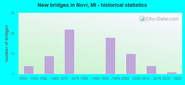
- New bridges - historical statistics
- 41950-1959
- 91960-1969
- 221970-1979
- 181990-1999
- 102000-2009
- 42010-2019
- 12020-2022
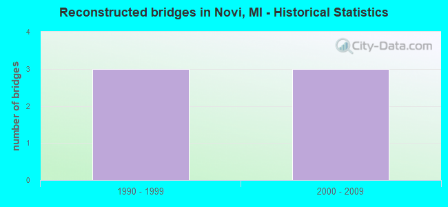
- Reconstructed bridges - Historical Statistics
- 31990-1999
- 32000-2009
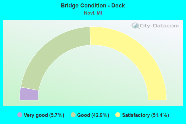
- Bridge Condition - Deck
- 5.7%Very good
- 42.9%Good
- 51.4%Satisfactory
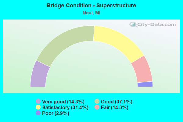
- Bridge Condition - Superstructure
- 14.3%Very good
- 37.1%Good
- 31.4%Satisfactory
- 14.3%Fair
- 2.9%Poor
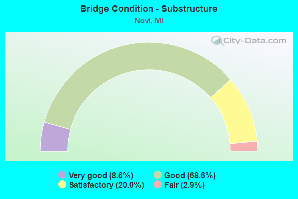
- Bridge Condition - Substructure
- 8.6%Very good
- 68.6%Good
- 20.0%Satisfactory
- 2.9%Fair
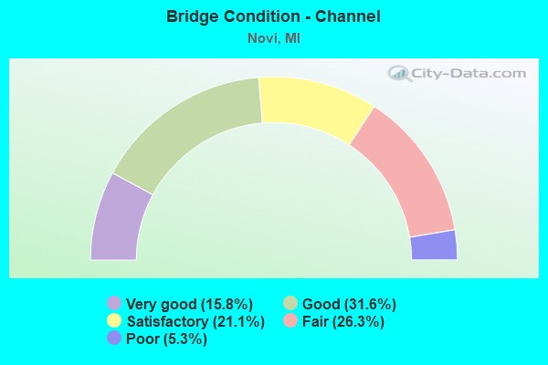
- Bridge Condition - Channel
- 15.8%Very good
- 31.6%Good
- 21.1%Satisfactory
- 26.3%Fair
- 5.3%Poor
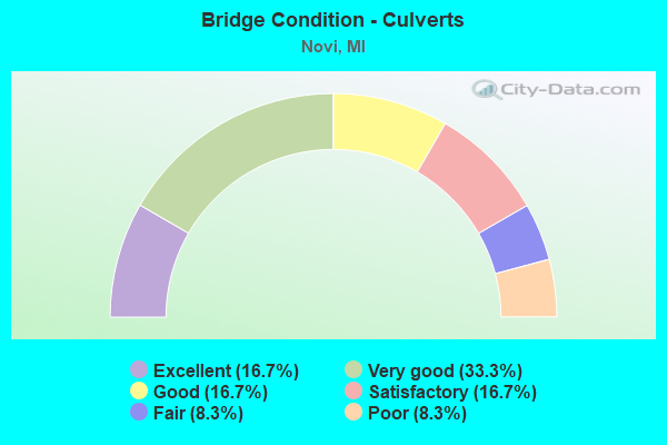
- Bridge Condition - Culverts
- 16.7%Excellent
- 33.3%Very good
- 16.7%Good
- 16.7%Satisfactory
- 8.3%Fair
- 8.3%Poor
Find on map >> Show street view
Structure Number: 812, Location: 0.5 MI E OF RED ARROW HWY (Lat: 41.943067, Lng: -86.566825), Route carried "on" structure: Interstate 94, Year Built: 1961, Year Reconstructed: 1998, Status: Open, Structure Length: 5.21m (17.09ft), Average Daily Traffic: 18,964 (year 2007), Truck Traffic: 31%, Average Future Daily Traffic: 22,772 (year 2018), Design Load: HS 25 or greater, Features Intersected: LAKE STREET
Minimum Vertical Clearance: 30.48m (100.00ft), Kilometerpoint: 26.574, Lanes on structure: 3, Lanes under structure: 2, Base Highway Network: Yes (Inventory Route: 136, Subroute: 4), Owner: State Highway Agency, Approaching Roadway Width: 15.2m (49.9ft), Skew: 1 degrees, Material/Design: Prestressed concrete, Design/Construction: Stringer/Multi-beam, Number Of Spans In Main Unit: 3, Length of Maximum Span: 17.3m (56.8ft), Curb-To-Curb Width: 17.8m (58.4ft), Out-to-Out Width: 18.6m (61.0ft)
Condition: Deck: Good, Superstructure: Good, Substructure: Satisfactory, Operating Rating: 63.5 metric tons, Method Used To Determine Operating Rating: Load Factor (LF) rating reported by rating factor (RF) method using MS18 loading, Inventory Rating: 31.8 metric tons, Method Used To Determine Inventory Rating: Load Factor (LF) rating reported by rating factor (RF) method using MS18 loading, Structural Evaluation: Equal to present minimum criteria, Deck Geometry: Better than present minimum criteria, Underclear: Better than present minimum criteria, Approach Roadway Alignment: Equal to present desirable criteria, Designated Inspection Frequency: Every 24 months, Inspection Date: May 2020, Deck Structure Type: Concrete Cast-file-Place, Wearing Surface/Protective System: Wearing Surface: Monolithic Concrete, Deck Protection: Epoxy Coated Reinforcing
Find on map >> Show street view
Structure Number: 1294, Location: CLARENDON TWP SEC 36 (Lat: 42.072461, Lng: -84.828817), Route carried "on" structure: County highway , Year Built: 1964, Status: Open, Structure Length: 2.43m (7.97ft), Average Daily Traffic: 530 (year 1995), Truck Traffic: 12%, Average Future Daily Traffic: 948 (year 2023), Design Load: H 20, Features Intersected: ST JOSEPH RIVER, Facility Carried by Structure: SOUTH COUNTY LINE
Minimum Vertical Clearance: 30.48m (100.00ft), Kilometerpoint: 3.024, Lanes on structure: 2, Owner: County Highway Agency, Approaching Roadway Width: 8.8m (28.9ft), Skew: 2 degrees, Material/Design: Prestressed concrete, Design/Construction: Box Beam or Girders - Multiple, Number Of Spans In Main Unit: 2, Length of Maximum Span: 12.2m (40.0ft), Curb or Sidewalk Widths: Left: 0.6m (2.0ft), Right: 0.6m (2.0ft), Curb-To-Curb Width: 7.9m (25.9ft), Out-to-Out Width: 9.6m (31.5ft)
Condition: Deck: Satisfactory, Superstructure: Fair, Substructure: Good, Channel: Fair, Operating Rating: 60.1 metric tons, Method Used To Determine Operating Rating: Load Factor (LF), Inventory Rating: 30.4 metric tons, Method Used To Determine Inventory Rating: Load Factor (LF), Structural Evaluation: Somewhat better than minimum adequacy, Deck Geometry: Somewhat better than minimum adequacy, Waterway Adequacy: Equal to present desirable criteria, Approach Roadway Alignment: Equal to present desirable criteria, Designated Inspection Frequency: Every 24 months, Inspection Date: September 2021, Deck Structure Type: Concrete Precast Panels, Wearing Surface/Protective System: Wearing Surface: Bituminous
Find on map >> Show street view
Structure Number: 1386, Location: 1 MI E OF BURLINGTON (Lat: 42.102831, Lng: -85.040194), Route carried "on" structure: County highway , Year Built: 1990, Status: Open, Structure Length: 4.57m (14.99ft), Average Daily Traffic: 75 (year 1994), Average Future Daily Traffic: 140 (year 2024), Design Load: HS 20, Features Intersected: ST JOSEPH RIVER, Facility Carried by Structure: 13 MILE ROAD
Minimum Vertical Clearance: 30.48m (100.00ft), Kilometerpoint: 1.746, Lanes on structure: 2, Owner: County Highway Agency, Approaching Roadway Width: 9.4m (30.8ft), Skew: 3 degrees, Material/Design: Prestressed concrete, Design/Construction: Box Beam or Girders - Multiple, Number Of Spans In Main Unit: 2, Length of Maximum Span: 22.8m (74.8ft), Curb-To-Curb Width: 8.7m (28.5ft), Out-to-Out Width: 9.6m (31.5ft)
Condition: Deck: Satisfactory, Superstructure: Satisfactory, Substructure: Good, Channel: Good, Operating Rating: 43.0 metric tons, Method Used To Determine Operating Rating: Load Factor (LF), Inventory Rating: 33.0 metric tons, Method Used To Determine Inventory Rating: Load Factor (LF), Structural Evaluation: Equal to present minimum criteria, Deck Geometry: Better than present minimum criteria, Waterway Adequacy: Equal to present desirable criteria, Approach Roadway Alignment: Equal to present desirable criteria, Designated Inspection Frequency: Every 24 months, Inspection Date: September 2020, Deck Structure Type: Concrete Precast Panels, Wearing Surface/Protective System: Wearing Surface: Bituminous
Find on map >> Show street view
Structure Number: 4258, Location: 6.1 MI S OF US-10 (Lat: 43.727936, Lng: -84.758308), Route carried "on" structure: County highway , Year Built: 1965, Status: Temporarily open, Structure Length: 6.22m (20.41ft), Average Daily Traffic: 180 (year 1974), Average Future Daily Traffic: 180 (year 1977), Design Load: H 15, Features Intersected: US-127, Facility Carried by Structure: VERNON RD
Minimum Vertical Clearance: 30.48m (100.00ft), Kilometerpoint: 26.497, Lanes on structure: 2, Lanes under structure: 4, Owner: State Highway Agency, Approaching Roadway Width: 10.3m (33.8ft), Material/Design: Prestressed concrete, Design/Construction: Stringer/Multi-beam, Number Of Spans In Main Unit: 4, Length of Maximum Span: 21.6m (70.9ft), Curb or Sidewalk Widths: Left: 0.4m (1.3ft), Right: 0.4m (1.3ft), Curb-To-Curb Width: 7.9m (25.9ft), Out-to-Out Width: 9.5m (31.2ft)
Condition: Deck: Satisfactory, Superstructure: Poor, Substructure: Good, Operating Rating: 59.3 metric tons, Method Used To Determine Operating Rating: Load Factor (LF) rating reported by rating factor (RF) method using MS18 loading, Inventory Rating: 34.0 metric tons, Method Used To Determine Inventory Rating: Load Factor (LF) rating reported by rating factor (RF) method using MS18 loading, Structural Evaluation: Meets minimum limits, Deck Geometry: Somewhat better than minimum adequacy, Underclear: Somewhat better than minimum adequacy, Approach Roadway Alignment: Better than present minimum criteria, Designated Inspection Frequency: Every 12 months, Inspection Date: Febuary 2022, Deck Structure Type: Concrete Cast-file-Place, Wearing Surface/Protective System: Wearing Surface: Monolithic Concrete
Find on map >> Show street view
Structure Number: 4758, Location: IN WALKER (Lat: 43.020378, Lng: -85.708628), Route carried "on" structure: Interstate 96, Year Built: 1961, Status: Open, Structure Length: 3.44m (11.29ft), Average Daily Traffic: 27,527 (year 2007), Truck Traffic: 7%, Average Future Daily Traffic: 33,602 (year 2018), Design Load: HS 20+Mod, Features Intersected: BRISTOL RD
Minimum Vertical Clearance: 30.48m (100.00ft), Kilometerpoint: 6.837, Lanes on structure: 2, Lanes under structure: 2, Base Highway Network: Yes (Inventory Route: 40, Subroute: 4), Owner: State Highway Agency, Approaching Roadway Width: 12.8m (42.0ft), Skew: 11 degrees, Material/Design: Steel, Design/Construction: Stringer/Multi-beam, Number Of Spans In Main Unit: 3, Length of Maximum Span: 12.8m (42.0ft), Curb-To-Curb Width: 13.2m (43.3ft), Out-to-Out Width: 14.3m (46.9ft)
Condition: Deck: Satisfactory, Superstructure: Fair, Substructure: Satisfactory, Operating Rating: 58.0 metric tons, Method Used To Determine Operating Rating: Load Factor (LF) rating reported by rating factor (RF) method using MS18 loading, Inventory Rating: 34.7 metric tons, Method Used To Determine Inventory Rating: Load Factor (LF) rating reported by rating factor (RF) method using MS18 loading, Structural Evaluation: Somewhat better than minimum adequacy, Deck Geometry: Superior to present desirable criteria, Underclear: Somewhat better than minimum adequacy, Approach Roadway Alignment: Equal to present desirable criteria, Designated Inspection Frequency: Every 24 months, Inspection Date: March 2021, Bridge Improvement Cost: $64,000, Deck Structure Type: Concrete Cast-file-Place, Wearing Surface/Protective System: Wearing Surface: Latex Concrete
Find on map >> Show street view
Structure Number: 5746, Location: 4.1 MI N OF I-96 (Lat: 42.582306, Lng: -83.737675), Route carried "on" structure: US 23, Year Built: 1962, Year Reconstructed: 2011, Status: Open, Structure Length: 3.26m (10.70ft), Average Daily Traffic: 34,200 (year 2011), Truck Traffic: 10%, Average Future Daily Traffic: 41,700 (year 2031), Design Load: HS 20, Features Intersected: HYNE RD
Minimum Vertical Clearance: 30.48m (100.00ft), Kilometerpoint: 17.782, Lanes on structure: 2, Lanes under structure: 2, Base Highway Network: Yes (Inventory Route: 93, Subroute: 10), Owner: State Highway Agency, Approaching Roadway Width: 13.7m (44.9ft), Material/Design: Steel, Design/Construction: Stringer/Multi-beam, Number Of Spans In Main Unit: 3, Length of Maximum Span: 12.5m (41.0ft), Curb-To-Curb Width: 13.4m (44.0ft), Out-to-Out Width: 14.4m (47.2ft)
Condition: Deck: Satisfactory, Superstructure: Fair, Substructure: Satisfactory, Operating Rating: 62.2 metric tons, Method Used To Determine Operating Rating: Load Factor (LF), Inventory Rating: 37.2 metric tons, Method Used To Determine Inventory Rating: Load Factor (LF), Structural Evaluation: Somewhat better than minimum adequacy, Deck Geometry: Superior to present desirable criteria, Underclear: Meets minimum limits, Approach Roadway Alignment: Equal to present desirable criteria, Designated Inspection Frequency: Every 24 months, Inspection Date: August 2020, Deck Structure Type: Concrete Cast-file-Place, Wearing Surface/Protective System: Wearing Surface: Latex Concrete
Find on map >> Show street view
Structure Number: 7794, Location: IN NOVI (Lat: 42.487967, Lng: -83.488322), Route carried "on" structure: Interstate 96, Year Built: 2008, Status: Open, Structure Length: 3.26m (10.70ft), Average Daily Traffic: 67,000 (year 2007), Truck Traffic: 8%, Average Future Daily Traffic: 83,000 (year 2029), Design Load: Greater than HL93, Features Intersected: CSX RR
Minimum Vertical Clearance: 30.48m (100.00ft), Kilometerpoint: 15.658, Lanes on structure: 3, Base Highway Network: Yes (Inventory Route: 65, Subroute: 3), Owner: State Highway Agency, Approaching Roadway Width: 19.6m (64.3ft), Skew: 14 degrees, Material/Design: Steel, Design/Construction: Stringer/Multi-beam, Number Of Spans In Main Unit: 1, Length of Maximum Span: 31.1m (102.0ft), Curb-To-Curb Width: 19.6m (64.3ft), Out-to-Out Width: 20.6m (67.6ft)
Condition: Deck: Good, Superstructure: Very good, Substructure: Very good, Inventory Rating: 77.0 metric tons, Method Used To Determine Inventory Rating: Load Factor (LF), Structural Evaluation: Equal to present desirable criteria, Deck Geometry: Superior to present desirable criteria, Approach Roadway Alignment: Equal to present desirable criteria, Designated Inspection Frequency: Every 24 months, Inspection Date: November 2020, Deck Structure Type: Concrete Cast-file-Place, Wearing Surface/Protective System: Wearing Surface: Monolithic Concrete, Deck Protection: Epoxy Coated Reinforcing
Find on map >> Show street view
Structure Number: 7795, Location: IN NOVI (Lat: 42.488200, Lng: -83.488572), Route carried "on" structure: Interstate 96, Year Built: 2008, Status: Open, Structure Length: 3.30m (10.83ft), Average Daily Traffic: 67,000 (year 2007), Truck Traffic: 8%, Average Future Daily Traffic: 83,000 (year 2029), Design Load: Greater than HL93, Features Intersected: CSX RR
Minimum Vertical Clearance: 30.48m (100.00ft), Kilometerpoint: 15.642, Lanes on structure: 3, Base Highway Network: Yes (Inventory Route: 65, Subroute: 4), Owner: State Highway Agency, Approaching Roadway Width: 19.6m (64.3ft), Skew: 14 degrees, Material/Design: Steel, Design/Construction: Stringer/Multi-beam, Number Of Spans In Main Unit: 1, Length of Maximum Span: 31.1m (102.0ft), Curb-To-Curb Width: 19.6m (64.3ft), Out-to-Out Width: 20.6m (67.6ft)
Condition: Deck: Good, Superstructure: Very good, Substructure: Very good, Inventory Rating: 77.5 metric tons, Method Used To Determine Inventory Rating: Load Factor (LF), Structural Evaluation: Equal to present desirable criteria, Deck Geometry: Superior to present desirable criteria, Approach Roadway Alignment: Equal to present desirable criteria, Designated Inspection Frequency: Every 24 months, Inspection Date: November 2020, Deck Structure Type: Concrete Cast-file-Place, Wearing Surface/Protective System: Wearing Surface: Monolithic Concrete, Deck Protection: Epoxy Coated Reinforcing
Find on map >> Show street view
Structure Number: 7802, Location: IN NOVI (Lat: 42.493592, Lng: -83.515822), Route carried "on" structure: County highway 2059, Year Built: 2003, Status: Open, Structure Length: 5.94m (19.49ft), Average Daily Traffic: 27,000 (year 2000), Truck Traffic: 4%, Average Future Daily Traffic: 38,000 (year 2015), Design Load: HS 25 or greater, Features Intersected: I-96, Facility Carried by Structure: BECK RD
Minimum Vertical Clearance: 30.48m (100.00ft), Kilometerpoint: 0.117, Lanes on structure: 4, Lanes under structure: 6, Base Highway Network: Yes (Inventory Route: 446, Subroute: 73), Owner: State Highway Agency, Approaching Roadway Width: 14.6m (47.9ft), Skew: 1 degrees, Material/Design: Prestressed concrete, Design/Construction: Stringer/Multi-beam, Number Of Spans In Main Unit: 2, Length of Maximum Span: 29.7m (97.4ft), Curb-To-Curb Width: 26.8m (87.9ft), Out-to-Out Width: 61.0m (200.1ft)
Condition: Deck: Good, Superstructure: Very good, Substructure: Good, Operating Rating: 61.5 metric tons, Method Used To Determine Operating Rating: Load Factor (LF), Inventory Rating: 45.2 metric tons, Method Used To Determine Inventory Rating: Load Factor (LF), Structural Evaluation: Better than present minimum criteria, Deck Geometry: Superior to present desirable criteria, Underclear: Somewhat better than minimum adequacy, Approach Roadway Alignment: Equal to present desirable criteria, Designated Inspection Frequency: Every 24 months, Inspection Date: November 2020, Deck Structure Type: Concrete Cast-file-Place, Wearing Surface/Protective System: Wearing Surface: Monolithic Concrete, Deck Protection: Epoxy Coated Reinforcing
Find on map >> Show street view
Structure Number: 7803, Location: IN NOVI (Lat: 42.487086, Lng: -83.475825), Route carried "on" structure: County highway 2059, Year Built: 1979, Status: Open, Structure Length: 6.92m (22.70ft), Average Daily Traffic: 36,571 (year 2018), Truck Traffic: 2%, Average Future Daily Traffic: 44,624 (year 2038), Design Load: HS 25 or greater, Features Intersected: I-96, Facility Carried by Structure: NOVI RD
Minimum Vertical Clearance: 30.48m (100.00ft), Kilometerpoint: 2.596, Lanes on structure: 6, Lanes under structure: 8, Base Highway Network: Yes (Inventory Route: 62, Subroute: 10), Owner: State Highway Agency, Approaching Roadway Width: 12.2m (40.0ft), Material/Design: Steel, Design/Construction: Stringer/Multi-beam, Number Of Spans In Main Unit: 2, Length of Maximum Span: 35.1m (115.2ft), Curb or Sidewalk Widths: Left: 2.5m (8.2ft), Right: 0.0m, Curb-To-Curb Width: 27.7m (90.9ft), Out-to-Out Width: 31.7m (104.0ft)
Condition: Deck: Good, Superstructure: Good, Substructure: Good, Operating Rating: 76.8 metric tons, Method Used To Determine Operating Rating: Load Factor (LF) rating reported by rating factor (RF) method using MS18 loading, Inventory Rating: 46.0 metric tons, Method Used To Determine Inventory Rating: Load Factor (LF) rating reported by rating factor (RF) method using MS18 loading, Structural Evaluation: Better than present minimum criteria, Deck Geometry: Equal to present desirable criteria, Underclear: High priority of corrective action, Approach Roadway Alignment: Equal to present desirable criteria, Length Of Structure Improvement: 6.92m (22.70ft), Designated Inspection Frequency: Every 23 months, Inspection Date: December 2020, Bridge Improvement Cost: $310,000, Roadway Improvement Cost: $17,000, Total Project Cost: $204,000, Deck Structure Type: Concrete Cast-file-Place, Wearing Surface/Protective System: Wearing Surface: Epoxy Overlay, Deck Protection: Epoxy Coated Reinforcing
Find on map >> Show street view
Structure Number: 7804, Location: E LTS OF NOVI (Lat: 42.480564, Lng: -83.435503), Route carried "on" structure: County highway 2059, Year Built: 1957, Year Reconstructed: 2001, Status: Open, Structure Length: 6.52m (21.39ft), Average Daily Traffic: 20,000 (year 1976), Truck Traffic: 3%, Average Future Daily Traffic: 20,000 (year 1977), Design Load: H 15, Features Intersected: M-5, Facility Carried by Structure: HAGGERTY RD
Minimum Vertical Clearance: 30.48m (100.00ft), Kilometerpoint: 4.679, Lanes on structure: 2, Lanes under structure: 4, Base Highway Network: Yes (Inventory Route: 63, Subroute: 5), Owner: State Highway Agency, Approaching Roadway Width: 10.3m (33.8ft), Skew: 2 degrees, Material/Design: Steel, Design/Construction: Stringer/Multi-beam, Number Of Spans In Main Unit: 4, Length of Maximum Span: 22.3m (73.2ft), Curb-To-Curb Width: 9.6m (31.5ft), Out-to-Out Width: 10.6m (34.8ft)
Condition: Deck: Good, Superstructure: Satisfactory, Substructure: Good, Operating Rating: 67.1 metric tons, Method Used To Determine Operating Rating: Load Factor (LF) rating reported by rating factor (RF) method using MS18 loading, Inventory Rating: 40.2 metric tons, Method Used To Determine Inventory Rating: Load Factor (LF) rating reported by rating factor (RF) method using MS18 loading, Structural Evaluation: Equal to present minimum criteria, Deck Geometry: Meets minimum limits, Underclear: High priority of corrective action, Approach Roadway Alignment: Better than present minimum criteria, Designated Inspection Frequency: Every 24 months, Inspection Date: November 2020, Deck Structure Type: Concrete Cast-file-Place, Wearing Surface/Protective System: Wearing Surface: Monolithic Concrete
Find on map >> Show street view
Structure Number: 7898, Location: @I-96 (I-696 EB) (Lat: 42.483019, Lng: -83.439344), Route carried "on" structure: State highway 5, Year Built: 2008, Status: Open, Structure Length: 7.21m (23.65ft), Average Daily Traffic: 18,060 (year 2007), Truck Traffic: 3%, Average Future Daily Traffic: 13,540 (year 2028), Design Load: Greater than HL93, Features Intersected: I-696 EB
Minimum Vertical Clearance: 30.48m (100.00ft), Kilometerpoint: 19.746, Lanes on structure: 2, Lanes under structure: 2, Base Highway Network: Yes (Inventory Route: 65, Subroute: 4), Owner: State Highway Agency, Approaching Roadway Width: 12.8m (42.0ft), Skew: 4 degrees, Material/Design: Steel continuous, Design/Construction: Stringer/Multi-beam, Number Of Spans In Main Unit: 3, Length of Maximum Span: 46.9m (153.9ft), Curb-To-Curb Width: 11.2m (36.7ft), Out-to-Out Width: 12.2m (40.0ft)
Condition: Deck: Very good, Superstructure: Very good, Substructure: Very good, Operating Rating: 55.7 metric tons, Method Used To Determine Operating Rating: Load and Resistance Factor Rating (LRFR) rating reported by rating factor(RF) method using HL-93 loadings, Inventory Rating: 43.1 metric tons, Method Used To Determine Inventory Rating: Load and Resistance Factor Rating (LRFR) rating reported by rating factor(RF) method using HL-93 loadings, Structural Evaluation: Equal to present desirable criteria, Deck Geometry: Meets minimum limits, Underclear: Meets minimum limits, Approach Roadway Alignment: Equal to present desirable criteria, Designated Inspection Frequency: Every 24 months, Inspection Date: March 2020, Deck Structure Type: Concrete Cast-file-Place, Wearing Surface/Protective System: Wearing Surface: Monolithic Concrete, Deck Protection: Epoxy Coated Reinforcing
Find on map >> Show street view
Structure Number: 8115, Location: IN THE VILLAGE OF NOVI (Lat: 42.485047, Lng: -83.455997), Route carried "on" structure: City street , Year Built: 1972, Year Reconstructed: 2008, Status: Open, Structure Length: 8.75m (28.71ft), Average Daily Traffic: 10,400 (year 2007), Truck Traffic: 5%, Average Future Daily Traffic: 12,100 (year 2007), Design Load: H 20, Features Intersected: I-96, Facility Carried by Structure: MEADOWBROOK RD
Minimum Vertical Clearance: 30.48m (100.00ft), Kilometerpoint: 5.213, Lanes on structure: 2, Lanes under structure: 9, Owner: State Highway Agency, Approaching Roadway Width: 12.5m (41.0ft), Skew: 1 degrees, Material/Design: Steel, Design/Construction: Stringer/Multi-beam, Number Of Spans In Main Unit: 2, Length of Maximum Span: 46.8m (153.5ft), Curb-To-Curb Width: 11.7m (38.4ft), Out-to-Out Width: 12.9m (42.3ft)
Condition: Deck: Satisfactory, Superstructure: Good, Substructure: Good, Operating Rating: 73.4 metric tons, Method Used To Determine Operating Rating: Load Factor (LF), Inventory Rating: 44.0 metric tons, Method Used To Determine Inventory Rating: Load Factor (LF), Structural Evaluation: Better than present minimum criteria, Deck Geometry: Somewhat better than minimum adequacy, Underclear: Somewhat better than minimum adequacy, Approach Roadway Alignment: Better than present minimum criteria, Designated Inspection Frequency: Every 24 months, Inspection Date: December 2020, Bridge Improvement Cost: $307,000, Roadway Improvement Cost: $19,000, Total Project Cost: $228,000, Deck Structure Type: Concrete Cast-file-Place, Wearing Surface/Protective System: Wearing Surface: Epoxy Overlay, Deck Protection: Epoxy Coated Reinforcing
Find on map >> Show street view
Structure Number: 8116, Location: E LTS OF NOVI (Lat: 42.478864, Lng: -83.435428), Route carried "on" structure: County highway 2059, Year Built: 1972, Status: Open, Structure Length: 7.07m (23.20ft), Average Daily Traffic: 26,556 (year 1995), Truck Traffic: 10%, Average Future Daily Traffic: 20,000 (year 2016), Design Load: H 20, Features Intersected: I-96 EB, Facility Carried by Structure: HAGGERTY RD
Minimum Vertical Clearance: 30.48m (100.00ft), Kilometerpoint: 4.489, Lanes on structure: 2, Lanes under structure: 3, Base Highway Network: Yes (Inventory Route: 63, Subroute: 5), Owner: State Highway Agency, Approaching Roadway Width: 13.1m (43.0ft), Skew: 3 degrees, Material/Design: Steel, Design/Construction: Stringer/Multi-beam, Number Of Spans In Main Unit: 3, Length of Maximum Span: 40.8m (133.9ft), Curb-To-Curb Width: 12.3m (40.4ft), Out-to-Out Width: 13.5m (44.3ft)
Condition: Deck: Satisfactory, Superstructure: Satisfactory, Substructure: Good, Operating Rating: 57.0 metric tons, Method Used To Determine Operating Rating: Load Factor (LF) rating reported by rating factor (RF) method using MS18 loading, Inventory Rating: 34.3 metric tons, Method Used To Determine Inventory Rating: Load Factor (LF) rating reported by rating factor (RF) method using MS18 loading, Structural Evaluation: Equal to present minimum criteria, Deck Geometry: Somewhat better than minimum adequacy, Underclear: Equal to present minimum criteria, Approach Roadway Alignment: Equal to present desirable criteria, Designated Inspection Frequency: Every 24 months, Inspection Date: November 2020, Bridge Improvement Cost: $268,000, Roadway Improvement Cost: $19,000, Total Project Cost: $227,000, Deck Structure Type: Concrete Cast-file-Place, Wearing Surface/Protective System: Wearing Surface: Epoxy Overlay
Find on map >> Show street view
Structure Number: 8117, Location: E LTS OF NOVI (Lat: 42.486025, Lng: -83.435761), Route carried "on" structure: County highway 2059, Year Built: 1971, Status: Open, Structure Length: 7.52m (24.67ft), Average Daily Traffic: 26,556 (year 1995), Truck Traffic: 10%, Average Future Daily Traffic: 20,000 (year 2016), Design Load: H 20, Features Intersected: I-96 WB, Facility Carried by Structure: HAGGERTY RD
Minimum Vertical Clearance: 30.48m (100.00ft), Kilometerpoint: 5.285, Lanes on structure: 2, Lanes under structure: 4, Base Highway Network: Yes (Inventory Route: 63, Subroute: 5), Owner: State Highway Agency, Approaching Roadway Width: 13.1m (43.0ft), Material/Design: Steel, Design/Construction: Stringer/Multi-beam, Number Of Spans In Main Unit: 4, Length of Maximum Span: 29.2m (95.8ft), Curb-To-Curb Width: 12.3m (40.4ft), Out-to-Out Width: 13.5m (44.3ft)
Condition: Deck: Satisfactory, Superstructure: Satisfactory, Substructure: Good, Operating Rating: 75.5 metric tons, Method Used To Determine Operating Rating: Load Factor (LF) rating reported by rating factor (RF) method using MS18 loading, Inventory Rating: 45.0 metric tons, Method Used To Determine Inventory Rating: Load Factor (LF) rating reported by rating factor (RF) method using MS18 loading, Structural Evaluation: Equal to present minimum criteria, Deck Geometry: Somewhat better than minimum adequacy, Underclear: Somewhat better than minimum adequacy, Approach Roadway Alignment: Equal to present desirable criteria, Designated Inspection Frequency: Every 24 months, Inspection Date: November 2020, Deck Structure Type: Concrete Cast-file-Place, Wearing Surface/Protective System: Wearing Surface: Epoxy Overlay
Find on map >> Show street view
Structure Number: 8118, Location: @ I-96/I-696 INTERCHANGE (Lat: 42.479428, Lng: -83.432058), Route carried "on" structure: Ramp Interstate 696, Year Built: 1971, Year Reconstructed: 1998, Status: Open, Structure Length: 8.56m (28.08ft), Average Daily Traffic: 16,434 (year 2007), Truck Traffic: 2%, Average Future Daily Traffic: 14,144 (year 2018), Design Load: HS 20+Mod, Features Intersected: M-5
Minimum Vertical Clearance: 30.48m (100.00ft), Kilometerpoint: 20.422, Lanes on structure: 3, Lanes under structure: 7, Owner: State Highway Agency, Approaching Roadway Width: 17.0m (55.8ft), Skew: 2 degrees, Material/Design: Steel, Design/Construction: Stringer/Multi-beam, Number Of Spans In Main Unit: 4, Length of Maximum Span: 34.5m (113.2ft), Curb-To-Curb Width: 15.2m (49.9ft), Out-to-Out Width: 15.9m (52.2ft)
Condition: Deck: Satisfactory, Superstructure: Fair, Substructure: Good, Operating Rating: 81.3 metric tons, Method Used To Determine Operating Rating: Load Factor (LF) rating reported by rating factor (RF) method using MS18 loading, Inventory Rating: 48.6 metric tons, Method Used To Determine Inventory Rating: Load Factor (LF) rating reported by rating factor (RF) method using MS18 loading, Structural Evaluation: Somewhat better than minimum adequacy, Deck Geometry: Superior to present desirable criteria, Underclear: Meets minimum limits, Approach Roadway Alignment: Equal to present desirable criteria, Designated Inspection Frequency: Every 24 months, Inspection Date: December 2020, Deck Structure Type: Concrete Cast-file-Place, Wearing Surface/Protective System: Wearing Surface: Epoxy Overlay
Find on map >> Show street view
Structure Number: 8119, Location: @ I-96/I-696 INTERCHANGE (Lat: 42.485197, Lng: -83.431444), Route carried "on" structure: Interstate 275, Year Built: 1971, Status: Open, Structure Length: 8.76m (28.74ft), Average Daily Traffic: 13,103 (year 2007), Truck Traffic: 3%, Average Future Daily Traffic: 9,980 (year 2018), Design Load: HS 20+Mod, Features Intersected: I-696
Minimum Vertical Clearance: 4.97m (16.31ft), Kilometerpoint: 8.821, Lanes on structure: 2, Lanes under structure: 4, Base Highway Network: Yes (Inventory Route: 440, Subroute: 6), Owner: State Highway Agency, Approaching Roadway Width: 13.1m (43.0ft), Skew: 2 degrees, Material/Design: Steel, Design/Construction: Stringer/Multi-beam, Number Of Spans In Main Unit: 4, Length of Maximum Span: 28.5m (93.5ft), Curb-To-Curb Width: 12.8m (42.0ft), Out-to-Out Width: 13.5m (44.3ft)
Condition: Deck: Satisfactory, Superstructure: Good, Substructure: Good, Operating Rating: 80.4 metric tons, Method Used To Determine Operating Rating: Load Factor (LF) rating reported by rating factor (RF) method using MS18 loading, Inventory Rating: 48.0 metric tons, Method Used To Determine Inventory Rating: Load Factor (LF) rating reported by rating factor (RF) method using MS18 loading, Structural Evaluation: Better than present minimum criteria, Deck Geometry: Somewhat better than minimum adequacy, Underclear: Better than present minimum criteria, Approach Roadway Alignment: Equal to present desirable criteria, Designated Inspection Frequency: Every 24 months, Inspection Date: November 2020, Bridge Improvement Cost: $285,000, Deck Structure Type: Concrete Cast-file-Place, Wearing Surface/Protective System: Wearing Surface: Latex Concrete
Find on map >> Show street view
Structure Number: 812, Location: @ I-96/I-696 INTERCHANGE (Lat: 42.485072, Lng: -83.431714), Route carried "on" structure: Interstate 96, Year Built: 1971, Status: Open, Structure Length: 8.76m (28.74ft), Average Daily Traffic: 89,817 (year 2007), Truck Traffic: 8%, Average Future Daily Traffic: 93,330 (year 2018), Design Load: HS 20+Mod, Features Intersected: I-696
Minimum Vertical Clearance: 5.02m (16.47ft), Kilometerpoint: 1.312, Lanes on structure: 2, Lanes under structure: 4, Base Highway Network: Yes (Inventory Route: 63, Subroute: 7), Owner: State Highway Agency, Approaching Roadway Width: 13.1m (43.0ft), Skew: 2 degrees, Material/Design: Steel, Design/Construction: Stringer/Multi-beam, Number Of Spans In Main Unit: 4, Length of Maximum Span: 28.5m (93.5ft), Curb-To-Curb Width: 12.8m (42.0ft), Out-to-Out Width: 13.5m (44.3ft)
Condition: Deck: Satisfactory, Superstructure: Good, Substructure: Good, Operating Rating: 79.4 metric tons, Method Used To Determine Operating Rating: Load Factor (LF) rating reported by rating factor (RF) method using MS18 loading, Inventory Rating: 47.6 metric tons, Method Used To Determine Inventory Rating: Load Factor (LF) rating reported by rating factor (RF) method using MS18 loading, Structural Evaluation: Better than present minimum criteria, Deck Geometry: Equal to present minimum criteria, Underclear: Somewhat better than minimum adequacy, Approach Roadway Alignment: Equal to present desirable criteria, Designated Inspection Frequency: Every 24 months, Inspection Date: November 2020, Bridge Improvement Cost: $1,087,000, Deck Structure Type: Concrete Cast-file-Place, Wearing Surface/Protective System: Wearing Surface: Epoxy Overlay
Find on map >> Show street view
Structure Number: 8121, Location: I-96 & I-696 INTERCHANGE (Lat: 42.485133, Lng: -83.431856), Route carried "on" structure: Ramp Interstate 696, Year Built: 1972, Status: Open, Structure Length: 19.17m (62.89ft), Average Daily Traffic: 8,280 (year 1982), Truck Traffic: 13%, Average Future Daily Traffic: 8,280 (year 1977), Design Load: HS 20+Mod, Features Intersected: I-96 & I-275
Minimum Vertical Clearance: 30.48m (100.00ft), Kilometerpoint: 1.159, Lanes on structure: 2, Lanes under structure: 3, Owner: State Highway Agency, Approaching Roadway Width: 14.0m (45.9ft), Material/Design: Steel, Design/Construction: Stringer/Multi-beam, Number Of Spans In Main Unit: 5, Length of Maximum Span: 49.9m (163.7ft), Curb-To-Curb Width: 12.3m (40.4ft), Out-to-Out Width: 13.5m (44.3ft)
Condition: Deck: Good, Superstructure: Satisfactory, Substructure: Satisfactory, Operating Rating: 75.8 metric tons, Method Used To Determine Operating Rating: Load Factor (LF) rating reported by rating factor (RF) method using MS18 loading, Inventory Rating: 45.4 metric tons, Method Used To Determine Inventory Rating: Load Factor (LF) rating reported by rating factor (RF) method using MS18 loading, Structural Evaluation: Equal to present minimum criteria, Deck Geometry: Superior to present desirable criteria, Underclear: High priority of corrective action, Approach Roadway Alignment: Equal to present desirable criteria, Designated Inspection Frequency: Every 24 months, Inspection Date: December 2020, Deck Structure Type: Concrete Cast-file-Place, Wearing Surface/Protective System: Wearing Surface: Integral Concrete
Find on map >> Show street view
Structure Number: 8122, Location: @ I-96/I-696 INTERCHANGE (Lat: 42.478383, Lng: -83.428128), Route carried "on" structure: Interstate 96, Year Built: 1971, Status: Open, Structure Length: 7.98m (26.18ft), Average Daily Traffic: 89,817 (year 2007), Truck Traffic: 8%, Average Future Daily Traffic: 93,330 (year 2018), Design Load: HS 20+Mod, Features Intersected: M-5
Minimum Vertical Clearance: 30.48m (100.00ft), Kilometerpoint: 2.189, Lanes on structure: 2, Lanes under structure: 6, Base Highway Network: Yes (Inventory Route: 63, Subroute: 7), Owner: State Highway Agency, Approaching Roadway Width: 14.0m (45.9ft), Material/Design: Steel, Design/Construction: Stringer/Multi-beam, Number Of Spans In Main Unit: 4, Length of Maximum Span: 31.5m (103.3ft), Curb-To-Curb Width: 12.3m (40.4ft), Out-to-Out Width: 13.5m (44.3ft)
Condition: Deck: Satisfactory, Superstructure: Good, Substructure: Satisfactory, Operating Rating: 97.2 metric tons, Method Used To Determine Operating Rating: Load Factor (LF) rating reported by rating factor (RF) method using MS18 loading, Inventory Rating: 59.9 metric tons, Method Used To Determine Inventory Rating: Load Factor (LF) rating reported by rating factor (RF) method using MS18 loading, Structural Evaluation: Equal to present minimum criteria, Deck Geometry: Better than present minimum criteria, Underclear: Equal to present minimum criteria, Approach Roadway Alignment: Equal to present desirable criteria, Designated Inspection Frequency: Every 24 months, Inspection Date: December 2020, Bridge Improvement Cost: $1,656,000, Roadway Improvement Cost: $166,000, Total Project Cost: $1,954,000, Deck Structure Type: Concrete Cast-file-Place, Wearing Surface/Protective System: Wearing Surface: Epoxy Overlay
Find on map >> Show street view
Structure Number: 8133, Location: I-96,I-696,M-5 INTRCHG (Lat: 42.496694, Lng: -83.446264), Route carried "on" structure: State highway 5, Year Built: 1993, Status: Open, Structure Length: 6.37m (20.90ft), Average Daily Traffic: 35,541 (year 2007), Truck Traffic: 1%, Average Future Daily Traffic: 21,885 (year 2018), Design Load: HS 25 or greater, Features Intersected: 12 MILE RD
Minimum Vertical Clearance: 30.48m (100.00ft), Kilometerpoint: 6.582, Lanes on structure: 3, Lanes under structure: 8, Base Highway Network: Yes (Inventory Route: 440, Subroute: 6), Owner: State Highway Agency, Approaching Roadway Width: 17.0m (55.8ft), Material/Design: Prestressed concrete, Design/Construction: Stringer/Multi-beam, Number Of Spans In Main Unit: 2, Length of Maximum Span: 31.7m (104.0ft), Curb-To-Curb Width: 18.2m (59.7ft), Out-to-Out Width: 19.3m (63.3ft)
Condition: Deck: Good, Superstructure: Good, Substructure: Good, Operating Rating: 72.6 metric tons, Method Used To Determine Operating Rating: Load Factor (LF) rating reported by rating factor (RF) method using MS18 loading, Inventory Rating: 32.1 metric tons, Method Used To Determine Inventory Rating: Load Factor (LF) rating reported by rating factor (RF) method using MS18 loading, Structural Evaluation: Better than present minimum criteria, Deck Geometry: Better than present minimum criteria, Underclear: Equal to present minimum criteria, Approach Roadway Alignment: Equal to present desirable criteria, Designated Inspection Frequency: Every 24 months, Inspection Date: March 2021, Deck Structure Type: Concrete Cast-file-Place, Wearing Surface/Protective System: Wearing Surface: Monolithic Concrete, Deck Protection: Epoxy Coated Reinforcing
Find on map >> Show street view
Structure Number: 8134, Location: I-96,I-696 M-5 INTRCHG (Lat: 42.496672, Lng: -83.446686), Route carried "on" structure: State highway 5, Year Built: 1993, Status: Open, Structure Length: 6.37m (20.90ft), Average Daily Traffic: 35,541 (year 2007), Truck Traffic: 1%, Average Future Daily Traffic: 21,885 (year 2018), Design Load: HS 20+Mod, Features Intersected: 12 MILE ROAD
Minimum Vertical Clearance: 30.48m (100.00ft), Kilometerpoint: 6.584, Lanes on structure: 3, Lanes under structure: 4, Base Highway Network: Yes (Inventory Route: 440, Subroute: 5), Owner: State Highway Agency, Approaching Roadway Width: 17.0m (55.8ft), Material/Design: Prestressed concrete, Design/Construction: Stringer/Multi-beam, Number Of Spans In Main Unit: 2, Length of Maximum Span: 31.7m (104.0ft), Curb-To-Curb Width: 18.2m (59.7ft), Out-to-Out Width: 19.3m (63.3ft)
Condition: Deck: Satisfactory, Superstructure: Satisfactory, Substructure: Good, Operating Rating: 72.6 metric tons, Method Used To Determine Operating Rating: Load Factor (LF) rating reported by rating factor (RF) method using MS18 loading, Inventory Rating: 32.1 metric tons, Method Used To Determine Inventory Rating: Load Factor (LF) rating reported by rating factor (RF) method using MS18 loading, Structural Evaluation: Equal to present minimum criteria, Deck Geometry: Better than present minimum criteria, Underclear: Equal to present minimum criteria, Approach Roadway Alignment: Equal to present desirable criteria, Designated Inspection Frequency: Every 24 months, Inspection Date: March 2021, Deck Structure Type: Concrete Cast-file-Place, Wearing Surface/Protective System: Wearing Surface: Monolithic Concrete, Deck Protection: Epoxy Coated Reinforcing
Find on map >> Show street view
Structure Number: 8135, Location: I-96, I-696, M-5 INTRCHG (Lat: 42.496708, Lng: -83.445889), Route carried "on" structure: State highway 5, Year Built: 1993, Status: Open, Structure Length: 6.37m (20.90ft), Average Daily Traffic: 13,500 (year 1992), Truck Traffic: 5%, Average Future Daily Traffic: 13,500 (year 2010), Design Load: HS 25 or greater, Features Intersected: 12 MILE RD
Minimum Vertical Clearance: 30.48m (100.00ft), Kilometerpoint: 1.016, Lanes on structure: 3, Lanes under structure: 8, Base Highway Network: Yes (Inventory Route: 441, Subroute: 16), Owner: State Highway Agency, Approaching Roadway Width: 13.4m (44.0ft), Material/Design: Prestressed concrete, Design/Construction: Stringer/Multi-beam, Number Of Spans In Main Unit: 2, Length of Maximum Span: 31.7m (104.0ft), Curb-To-Curb Width: 17.0m (55.8ft), Out-to-Out Width: 18.0m (59.1ft)
Condition: Deck: Good, Superstructure: Good, Substructure: Good, Operating Rating: 76.5 metric tons, Method Used To Determine Operating Rating: Load Factor (LF) rating reported by rating factor (RF) method using MS18 loading, Inventory Rating: 33.4 metric tons, Method Used To Determine Inventory Rating: Load Factor (LF) rating reported by rating factor (RF) method using MS18 loading, Structural Evaluation: Better than present minimum criteria, Deck Geometry: Equal to present minimum criteria, Underclear: Equal to present minimum criteria, Approach Roadway Alignment: Equal to present desirable criteria, Designated Inspection Frequency: Every 24 months, Inspection Date: March 2021, Bridge Improvement Cost: $944,000, Deck Structure Type: Concrete Cast-file-Place, Wearing Surface/Protective System: Wearing Surface: Monolithic Concrete, Deck Protection: Epoxy Coated Reinforcing
Find on map >> Show street view
Structure Number: 8136, Location: I-96,I696,M-5 INTRCHG (Lat: 42.496661, Lng: -83.447039), Route carried "on" structure: State highway 5, Year Built: 1993, Status: Open, Structure Length: 6.37m (20.90ft), Average Daily Traffic: 13,500 (year 1992), Truck Traffic: 5%, Average Future Daily Traffic: 13,500 (year 2010), Design Load: HS 25 or greater, Features Intersected: 12 MILE RD
Minimum Vertical Clearance: 30.48m (100.00ft), Kilometerpoint: 1.016, Lanes on structure: 3, Lanes under structure: 8, Base Highway Network: Yes (Inventory Route: 441, Subroute: 12), Owner: State Highway Agency, Approaching Roadway Width: 13.4m (44.0ft), Material/Design: Prestressed concrete, Design/Construction: Stringer/Multi-beam, Number Of Spans In Main Unit: 2, Length of Maximum Span: 31.7m (104.0ft), Curb-To-Curb Width: 17.0m (55.8ft), Out-to-Out Width: 18.0m (59.1ft)
Condition: Deck: Good, Superstructure: Satisfactory, Substructure: Good, Operating Rating: 76.5 metric tons, Method Used To Determine Operating Rating: Load Factor (LF) rating reported by rating factor (RF) method using MS18 loading, Inventory Rating: 33.4 metric tons, Method Used To Determine Inventory Rating: Load Factor (LF) rating reported by rating factor (RF) method using MS18 loading, Structural Evaluation: Equal to present minimum criteria, Deck Geometry: Equal to present minimum criteria, Underclear: Meets minimum limits, Approach Roadway Alignment: Equal to present desirable criteria, Designated Inspection Frequency: Every 24 months, Inspection Date: March 2021, Bridge Improvement Cost: $944,000, Wearing Surface/Protective System: Wearing Surface: Monolithic Concrete, Deck Protection: Epoxy Coated Reinforcing
Find on map >> Show street view
Structure Number: 8142, Location: BET 8 AND 9 MILE RDS (Lat: 42.442400, Lng: -83.474200), Route carried "on" structure: County highway 2059, Year Built: 1959, Status: Open, Structure Length: 1.61m (5.28ft), Average Daily Traffic: 23,351 (year 1989), Average Future Daily Traffic: 28,000 (year 2016), Design Load: HS 20+Mod, Features Intersected: ROUGE RIVER, Facility Carried by Structure: NOVI RD
Minimum Vertical Clearance: 30.48m (100.00ft), Kilometerpoint: 7.867, Lanes on structure: 2, Base Highway Network: Yes (Inventory Route: 62, Subroute: 10), Owner: County Highway Agency, Approaching Roadway Width: 11.0m (36.1ft), Material/Design: Concrete continuous, Design/Construction: Slab, Number Of Spans In Main Unit: 1, Number Of Approach Spans: 2, Length of Maximum Span: 6.4m (21.0ft), Curb or Sidewalk Widths: Left: 1.5m (4.9ft), Right: 1.5m (4.9ft), Curb-To-Curb Width: 7.9m (25.9ft), Out-to-Out Width: 11.5m (37.7ft)
Condition: Deck: Satisfactory, Superstructure: Satisfactory, Substructure: Satisfactory, Channel: Poor, Operating Rating: 37.1 metric tons, Method Used To Determine Operating Rating: Load Factor (LF), Inventory Rating: 22.2 metric tons, Method Used To Determine Inventory Rating: Load Factor (LF), Structural Evaluation: Somewhat better than minimum adequacy, Deck Geometry: High priority of replacement, Waterway Adequacy: High priority of corrective action, Approach Roadway Alignment: Equal to present minimum criteria, Length Of Structure Improvement: 2.44m (8.01ft), Designated Inspection Frequency: Every 24 months, Inspection Date: June 2020, Bridge Improvement Cost: $220,000, Roadway Improvement Cost: $80,000, Total Project Cost: $359,000, Deck Structure Type: Concrete Cast-file-Place, Wearing Surface/Protective System: Wearing Surface: Monolithic Concrete
Find on map >> Show street view
Structure Number: 8167, Location: BET NOVI AND TAFT RDS (Lat: 42.482267, Lng: -83.481986), Route carried "on" structure: County highway 2059, Year Built: 2004, Status: Open, Structure Length: 2.78m (9.12ft), Average Daily Traffic: 15,740 (year 2012), Truck Traffic: 5%, Average Future Daily Traffic: 21,200 (year 2037), Design Load: HS 20+Mod, Features Intersected: CSX RR, Facility Carried by Structure: GRAND RIVER AVE
Minimum Vertical Clearance: 30.48m (100.00ft), Kilometerpoint: 17.728, Lanes on structure: 5, Owner: County Highway Agency, Approaching Roadway Width: 20.9m (68.6ft), Skew: 3 degrees, Material/Design: Prestressed concrete, Design/Construction: Box Beam or Girders - Multiple, Number Of Spans In Main Unit: 1, Length of Maximum Span: 13.9m (45.6ft), Curb or Sidewalk Widths: Left: 2.4m (7.9ft), Right: 2.4m (7.9ft), Curb-To-Curb Width: 20.9m (68.6ft), Out-to-Out Width: 27.6m (90.6ft)
Condition: Deck: Satisfactory, Superstructure: Satisfactory, Substructure: Good, Operating Rating: 78.7 metric tons, Method Used To Determine Operating Rating: Load Factor (LF) rating reported by rating factor (RF) method using MS18 loading, Inventory Rating: 47.3 metric tons, Method Used To Determine Inventory Rating: Load Factor (LF) rating reported by rating factor (RF) method using MS18 loading, Structural Evaluation: Equal to present minimum criteria, Deck Geometry: Somewhat better than minimum adequacy, Underclear: Equal to present desirable criteria, Approach Roadway Alignment: Equal to present desirable criteria, Designated Inspection Frequency: Every 24 months, Inspection Date: June 2020, Deck Structure Type: Concrete Cast-file-Place, Wearing Surface/Protective System: Wearing Surface: Integral Concrete, Deck Protection: Epoxy Coated Reinforcing
Find on map >> Show street view
Structure Number: 8173, Location: N OF BASE LINE RELOCATION (Lat: 42.440200, Lng: -83.476100), Route carried "on" structure: County highway 2059, Year Built: 1959, Status: Open, Structure Length: 1.22m (4.00ft), Average Daily Traffic: 10,882 (year 1997), Truck Traffic: 5%, Average Future Daily Traffic: 15,000 (year 2017), Design Load: HS 20+Mod, Features Intersected: ROUGE RIVER, Facility Carried by Structure: NOVI
Minimum Vertical Clearance: 30.48m (100.00ft), Kilometerpoint: 7.532, Lanes on structure: 2, Base Highway Network: Yes (Inventory Route: 62, Subroute: 10), Owner: County Highway Agency, Approaching Roadway Width: 11.6m (38.1ft), Material/Design: Steel, Design/Construction: Culvert, Number Of Spans In Main Unit: 3, Length of Maximum Span: 3.7m (12.1ft), Curb-To-Curb Width: 72.5m (237.9ft), Out-to-Out Width: 73.2m (240.2ft)
Condition: Channel: Fair, Culverts: Fair, Operating Rating: 97.2 metric tons, Method Used To Determine Operating Rating: Load Factor (LF) rating reported by rating factor (RF) method using MS18 loading, Inventory Rating: 97.2 metric tons, Method Used To Determine Inventory Rating: Load Factor (LF) rating reported by rating factor (RF) method using MS18 loading, Structural Evaluation: Somewhat better than minimum adequacy, Deck Geometry: Superior to present desirable criteria, Waterway Adequacy: Equal to present desirable criteria, Approach Roadway Alignment: Equal to present minimum criteria, Designated Inspection Frequency: Every 24 months, Inspection Date: June 2020
Find on map >> Show street view
Structure Number: 8246, Location: 0.4 MI N OF NINE MILE RD (Lat: 42.472061, Lng: -83.455322), Route carried "on" structure: City street , Year Built: 1976, Year Reconstructed: 2005, Status: Open, Structure Length: 1.89m (6.20ft), Average Daily Traffic: 9,100 (year 2018), Truck Traffic: 2%, Average Future Daily Traffic: 10,000 (year 2038), Design Load: HS 20, Features Intersected: COURTER DITCH, Facility Carried by Structure: MEADOWBROOK RD
Minimum Vertical Clearance: 30.48m (100.00ft), Kilometerpoint: 3.753, Lanes on structure: 2, Owner: City or Municipal Highway Agency, Approaching Roadway Width: 8.6m (28.2ft), Skew: 1 degrees, Material/Design: Prestressed concrete, Design/Construction: Box Beam or Girders - Multiple, Number Of Spans In Main Unit: 1, Length of Maximum Span: 18.5m (60.7ft), Curb or Sidewalk Widths: Left: 3.0m (9.8ft), Right: 2.1m (6.9ft), Curb-To-Curb Width: 8.6m (28.2ft), Out-to-Out Width: 13.6m (44.6ft)
Condition: Deck: Very good, Superstructure: Good, Substructure: Good, Channel: Very good, Operating Rating: 94.6 metric tons, Method Used To Determine Operating Rating: Load Factor (LF), Inventory Rating: 72.7 metric tons, Method Used To Determine Inventory Rating: Load Factor (LF), Structural Evaluation: Better than present minimum criteria, Deck Geometry: High priority of replacement, Waterway Adequacy: Equal to present desirable criteria, Approach Roadway Alignment: Equal to present desirable criteria, Designated Inspection Frequency: Every 24 months, Inspection Date: September 2020, Deck Structure Type: Concrete Cast-file-Place, Wearing Surface/Protective System: Wearing Surface: Epoxy Overlay
Find on map >> Show street view
Structure Number: 8247, Location: 0.3 MI S OF TEN MILE RD (Lat: 42.462758, Lng: -83.445219), Route carried "on" structure: City street , Year Built: 1974, Status: Open, Structure Length: 1.43m (4.69ft), Average Daily Traffic: 1,415 (year 1991), Truck Traffic: 3%, Average Future Daily Traffic: 1,600 (year 2012), Design Load: HS 20+Mod, Features Intersected: COURTER DITCH, Facility Carried by Structure: WILLOWBROOK ST
Minimum Vertical Clearance: 30.48m (100.00ft), Kilometerpoint: 0.346, Lanes on structure: 2, Owner: City or Municipal Highway Agency, Approaching Roadway Width: 7.6m (24.9ft), Skew: 2 degrees, Material/Design: Prestressed concrete, Design/Construction: Tee Beam, Number Of Spans In Main Unit: 1, Length of Maximum Span: 13.4m (44.0ft), Curb or Sidewalk Widths: Left: 1.8m (5.9ft), Right: 1.8m (5.9ft), Curb-To-Curb Width: 7.9m (25.9ft), Out-to-Out Width: 12.0m (39.4ft)
Condition: Deck: Satisfactory, Superstructure: Satisfactory, Substructure: Satisfactory, Channel: Satisfactory, Operating Rating: 54.6 metric tons, Method Used To Determine Operating Rating: Field evaluation and documented engineering judgment, Inventory Rating: 32.7 metric tons, Method Used To Determine Inventory Rating: Field evaluation and documented engineering judgment, Structural Evaluation: Equal to present minimum criteria, Deck Geometry: Meets minimum limits, Waterway Adequacy: Equal to present desirable criteria, Approach Roadway Alignment: Equal to present minimum criteria, Designated Inspection Frequency: Every 24 months, Inspection Date: September 2020, Deck Structure Type: Concrete Precast Panels, Wearing Surface/Protective System: Wearing Surface: Bituminous
Find on map >> Show street view
Structure Number: 8248, Location: 0.1 MI S OF TEN MILE RD (Lat: 42.465742, Lng: -83.442808), Route carried "on" structure: City street , Year Built: 1974, Status: Open, Structure Length: 1.28m (4.20ft), Average Daily Traffic: 1,300 (year 1992), Truck Traffic: 2%, Average Future Daily Traffic: 1,600 (year 2012), Design Load: HS 20+Mod, Features Intersected: COURTER DITCH, Facility Carried by Structure: CRANBROOKE DRIVE
Minimum Vertical Clearance: 30.48m (100.00ft), Kilometerpoint: 1.522, Lanes on structure: 2, Owner: City or Municipal Highway Agency, Approaching Roadway Width: 12.2m (40.0ft), Skew: 20 degrees, Material/Design: Prestressed concrete, Design/Construction: Tee Beam, Number Of Spans In Main Unit: 1, Length of Maximum Span: 11.8m (38.7ft), Curb or Sidewalk Widths: Left: 1.8m (5.9ft), Right: 1.8m (5.9ft), Curb-To-Curb Width: 12.2m (40.0ft), Out-to-Out Width: 23.2m (76.1ft)
Condition: Deck: Good, Superstructure: Fair, Substructure: Good, Channel: Satisfactory, Operating Rating: 54.6 metric tons, Method Used To Determine Operating Rating: Field evaluation and documented engineering judgment, Inventory Rating: 32.7 metric tons, Method Used To Determine Inventory Rating: Field evaluation and documented engineering judgment, Structural Evaluation: Somewhat better than minimum adequacy, Deck Geometry: Better than present minimum criteria, Waterway Adequacy: Equal to present desirable criteria, Approach Roadway Alignment: Equal to present desirable criteria, Designated Inspection Frequency: Every 24 months, Inspection Date: September 2020, Deck Structure Type: Concrete Precast Panels, Wearing Surface/Protective System: Wearing Surface: Other, Membrane: Preformed Fabric
Find on map >> Show street view
Structure Number: 12285, Location: NORTHVILLE T N/FIVE MILE (Lat: 42.396142, Lng: -83.529953), Route carried "on" structure: County highway , Year Built: 2018, Status: Open, Structure Length: 1.02m (3.35ft), Average Daily Traffic: 299 (year 1996), Truck Traffic: 2%, Average Future Daily Traffic: 364 (year 2015), Design Load: HL 93, Features Intersected: MIDDLE ROUGE JOHNSON DR., Facility Carried by Structure: RIDGE ROAD
Minimum Vertical Clearance: 30.48m (100.00ft), Kilometerpoint: 10.218, Lanes on structure: 2, Owner: County Highway Agency, Approaching Roadway Width: 10.3m (33.8ft), Skew: 2 degrees, Material/Design: Concrete, Design/Construction: Culvert, Number Of Spans In Main Unit: 1, Length of Maximum Span: 9.1m (29.9ft), Curb-To-Curb Width: 7.3m (24.0ft), Out-to-Out Width: 24.4m (80.1ft)
Condition: Channel: Very good, Culverts: Excellent, Operating Rating: 71.3 metric tons, Method Used To Determine Operating Rating: Load and Resistance Factor Rating (LRFR) rating reported by rating factor(RF) method using HL-93 loadings, Inventory Rating: 61.6 metric tons, Method Used To Determine Inventory Rating: Load and Resistance Factor Rating (LRFR) rating reported by rating factor(RF) method using HL-93 loadings, Structural Evaluation: Superior to present desirable criteria, Deck Geometry: Somewhat better than minimum adequacy, Waterway Adequacy: Equal to present desirable criteria, Approach Roadway Alignment: Equal to present desirable criteria, Designated Inspection Frequency: Every 24 months, Inspection Date: January 2021, Wearing Surface/Protective System: Wearing Surface: Gravel
Find on map >> Show street view
Structure Number: 12769, Location: CITY OF NOVI (Lat: 42.505442, Lng: -83.507361), Route carried "on" structure: City street , Year Built: 1999, Status: Open, Structure Length: 4.61m (15.12ft), Average Daily Traffic: 11,500 (year 2018), Truck Traffic: 2%, Average Future Daily Traffic: 12,600 (year 2038), Design Load: HS 25 or greater, Features Intersected: CSX RR, Facility Carried by Structure: WEST PARK DRIVE
Minimum Vertical Clearance: 30.48m (100.00ft), Kilometerpoint: 1.167, Lanes on structure: 2, Owner: City or Municipal Highway Agency, Approaching Roadway Width: 11.0m (36.1ft), Skew: 3 degrees, Material/Design: Prestressed concrete, Design/Construction: Box Beam or Girders - Multiple, Number Of Spans In Main Unit: 3, Length of Maximum Span: 20.4m (66.9ft), Curb or Sidewalk Widths: Left: 2.4m (7.9ft), Right: 2.4m (7.9ft), Curb-To-Curb Width: 11.0m (36.1ft), Out-to-Out Width: 19.3m (63.3ft)
Condition: Deck: Good, Superstructure: Good, Substructure: Good, Operating Rating: 97.2 metric tons, Method Used To Determine Operating Rating: Load Factor (LF) rating reported by rating factor (RF) method using MS18 loading, Inventory Rating: 60.6 metric tons, Method Used To Determine Inventory Rating: Load Factor (LF) rating reported by rating factor (RF) method using MS18 loading, Structural Evaluation: Better than present minimum criteria, Deck Geometry: Meets minimum limits, Underclear: High priority of corrective action, Approach Roadway Alignment: Equal to present desirable criteria, Designated Inspection Frequency: Every 24 months, Inspection Date: September 2020, Deck Structure Type: Concrete Precast Panels, Wearing Surface/Protective System: Wearing Surface: Epoxy Overlay, Deck Protection: Epoxy Coated Reinforcing
Find on map >> Show street view
Structure Number: 1294, Location: NOVI TWP SEC 13 (Lat: 42.484200, Lng: -83.448111), Route carried "on" structure: Interstate 96, Year Built: 1992, Status: Open, Structure Length: 28.76m (94.36ft), Average Daily Traffic: 5,600 (year 2000), Truck Traffic: 7%, Average Future Daily Traffic: 5,600 (year 2010), Design Load: HS 25 or greater, Features Intersected: M-5 SB / I-96 / I-697
Minimum Vertical Clearance: 30.48m (100.00ft), Kilometerpoint: 2.441, Lanes on structure: 2, Lanes under structure: 12, Base Highway Network: Yes (Inventory Route: 441, Subroute: 16), Owner: State Highway Agency, Approaching Roadway Width: 11.3m (37.1ft), Material/Design: Steel, Design/Construction: Stringer/Multi-beam, Number Of Spans In Main Unit: 7, Length of Maximum Span: 47.5m (155.8ft), Curb-To-Curb Width: 13.4m (44.0ft), Out-to-Out Width: 14.4m (47.2ft)
Condition: Deck: Good, Superstructure: Good, Substructure: Good, Operating Rating: 69.0 metric tons, Method Used To Determine Operating Rating: Load Factor (LF) rating reported by rating factor (RF) method using MS18 loading, Inventory Rating: 41.1 metric tons, Method Used To Determine Inventory Rating: Load Factor (LF) rating reported by rating factor (RF) method using MS18 loading, Structural Evaluation: Better than present minimum criteria, Deck Geometry: Superior to present desirable criteria, Underclear: Superior to present desirable criteria, Approach Roadway Alignment: Superior to present desirable criteria, Designated Inspection Frequency: Every 24 months, Inspection Date: November 2020, Deck Structure Type: Concrete Cast-file-Place, Wearing Surface/Protective System: Wearing Surface: Monolithic Concrete, Deck Protection: Epoxy Coated Reinforcing
Find on map >> Show street view
Structure Number: 12941, Location: NOVI TWP SEC 13 (Lat: 42.484600, Lng: -83.448056), Route carried "on" structure: State highway 5, Year Built: 1992, Status: Open, Structure Length: 13.99m (45.90ft), Average Daily Traffic: 53,522 (year 2007), Truck Traffic: 1%, Average Future Daily Traffic: 43,771 (year 2018), Design Load: HS 25 or greater, Features Intersected: I-96/I-696
Minimum Vertical Clearance: 5.45m (17.88ft), Kilometerpoint: 7.984, Lanes on structure: 3, Lanes under structure: 5, Base Highway Network: Yes (Inventory Route: 440, Subroute: 5), Owner: State Highway Agency, Approaching Roadway Width: 17.7m (58.1ft), Skew: 3 degrees, Material/Design: Steel, Design/Construction: Stringer/Multi-beam, Number Of Spans In Main Unit: 4, Length of Maximum Span: 52.4m (171.9ft), Curb-To-Curb Width: 18.2m (59.7ft), Out-to-Out Width: 19.2m (63.0ft)
Condition: Deck: Good, Superstructure: Good, Substructure: Good, Operating Rating: 68.0 metric tons, Method Used To Determine Operating Rating: Load Factor (LF) rating reported by rating factor (RF) method using MS18 loading, Inventory Rating: 40.5 metric tons, Method Used To Determine Inventory Rating: Load Factor (LF) rating reported by rating factor (RF) method using MS18 loading, Structural Evaluation: Better than present minimum criteria, Deck Geometry: Better than present minimum criteria, Underclear: Equal to present minimum criteria, Approach Roadway Alignment: Equal to present desirable criteria, Designated Inspection Frequency: Every 24 months, Inspection Date: November 2020, Deck Structure Type: Concrete Cast-file-Place, Wearing Surface/Protective System: Wearing Surface: Monolithic Concrete, Deck Protection: Epoxy Coated Reinforcing
Find on map >> Show street view
Structure Number: 12942, Location: NOVI TWP SEC 13 (Lat: 42.488258, Lng: -83.445650), Route carried "on" structure: Interstate 96, Year Built: 2000, Status: Open, Structure Length: 10.33m (33.89ft), Average Daily Traffic: 5,600 (year 1998), Average Future Daily Traffic: 5,600 (year 2010), Design Load: HS 25 or greater, Features Intersected: M-5 NB
Minimum Vertical Clearance: 30.48m (100.00ft), Kilometerpoint: 1.970, Lanes on structure: 2, Lanes under structure: 3, Base Highway Network: Yes (Inventory Route: 441, Subroute: 16), Owner: State Highway Agency, Approaching Roadway Width: 14.3m (46.9ft), Skew: 5 degrees, Material/Design: Steel, Design/Construction: Stringer/Multi-beam, Number Of Spans In Main Unit: 3, Length of Maximum Span: 56.5m (185.4ft), Curb-To-Curb Width: 13.4m (44.0ft), Out-to-Out Width: 14.4m (47.2ft)
Condition: Deck: Satisfactory, Superstructure: Satisfactory, Substructure: Good, Operating Rating: 84.3 metric tons, Method Used To Determine Operating Rating: Load Factor (LF), Inventory Rating: 40.9 metric tons, Method Used To Determine Inventory Rating: Load Factor (LF), Structural Evaluation: Equal to present minimum criteria, Deck Geometry: Superior to present desirable criteria, Underclear: Equal to present desirable criteria, Approach Roadway Alignment: Better than present minimum criteria, Designated Inspection Frequency: Every 24 months, Inspection Date: November 2020, Deck Structure Type: Concrete Cast-file-Place, Wearing Surface/Protective System: Wearing Surface: Monolithic Concrete, Deck Protection: Epoxy Coated Reinforcing
Find on map >> Show street view
Structure Number: 13506, Location: S OF GRAND RIVER AVE (Lat: 42.476019, Lng: -83.475272), Route carried "on" structure: County highway 2059, Year Built: 2011, Status: Open, Structure Length: 6.62m (21.72ft), Average Daily Traffic: 19,810 (year 2010), Average Future Daily Traffic: 26,680 (year 2030), Design Load: Greater than HL93, Features Intersected: CSX RR & MID ROUGE RIVER, Facility Carried by Structure: NOVI RD
Minimum Vertical Clearance: 30.48m (100.00ft), Kilometerpoint: 3.792, Lanes on structure: 5, Base Highway Network: Yes (Inventory Route: 62, Subroute: 10), Owner: County Highway Agency, Approaching Roadway Width: 19.5m (64.0ft), Skew: 5 degrees, Material/Design: Prestressed concrete, Design/Construction: Stringer/Multi-beam, Number Of Spans In Main Unit: 2, Length of Maximum Span: 33.1m (108.6ft), Curb or Sidewalk Widths: Left: 5.2m (17.1ft), Right: 5.2m (17.1ft), Curb-To-Curb Width: 19.5m (64.0ft), Out-to-Out Width: 29.0m (95.1ft)
Condition: Deck: Good, Superstructure: Very good, Substructure: Good, Channel: Very good, Operating Rating: 74.5 metric tons, Method Used To Determine Operating Rating: Load and Resistance Factor Rating (LRFR) rating reported by rating factor(RF) method using HL-93 loadings, Inventory Rating: 38.9 metric tons, Method Used To Determine Inventory Rating: Load and Resistance Factor Rating (LRFR) rating reported by rating factor(RF) method using HL-93 loadings, Structural Evaluation: Better than present minimum criteria, Deck Geometry: Meets minimum limits, Waterway Adequacy: Equal to present minimum criteria, Approach Roadway Alignment: Equal to present desirable criteria, Designated Inspection Frequency: Every 24 months, Inspection Date: June 2020, Deck Structure Type: Concrete Cast-file-Place, Wearing Surface/Protective System: Wearing Surface: Monolithic Concrete, Deck Protection: Epoxy Coated Reinforcing
Find on map >> Show street view
Structure Number: 13513, Location: 3.4 MI E OF LIVINGSTON CO (Lat: 42.515994, Lng: -83.605719), Route carried "on" structure: Interstate 96, Year Built: 2011, Status: Open, Structure Length: 0.82m (2.69ft), Average Daily Traffic: 110,180 (year 2007), Truck Traffic: 7%, Average Future Daily Traffic: 166,000 (year 2029), Design Load: HL 93, Features Intersected: HURON VALLEY TRAIL
Minimum Vertical Clearance: 30.48m (100.00ft), Kilometerpoint: 5.511, Lanes on structure: 6, Base Highway Network: Yes (Inventory Route: 65, Subroute: 3), Owner: State Highway Agency, Approaching Roadway Width: 19.8m (65.0ft), Skew: 1 degrees, Material/Design: Concrete, Design/Construction: Culvert, Number Of Spans In Main Unit: 1, Length of Maximum Span: 7.6m (24.9ft), Curb-To-Curb Width: 40.2m (131.9ft), Out-to-Out Width: 55.2m (181.1ft)
Condition: Culverts: Very good, Operating Rating: 97.2 metric tons, Method Used To Determine Operating Rating: Load and Resistance Factor Rating (LRFR) rating reported by rating factor(RF) method using HL-93 loadings, Inventory Rating: 97.2 metric tons, Method Used To Determine Inventory Rating: Load and Resistance Factor Rating (LRFR) rating reported by rating factor(RF) method using HL-93 loadings, Structural Evaluation: Equal to present desirable criteria, Deck Geometry: Superior to present desirable criteria, Approach Roadway Alignment: Equal to present desirable criteria, Designated Inspection Frequency: Every 24 months, Inspection Date: November 2020, Wearing Surface/Protective System: Wearing Surface: Bituminous
Find on map >> Show street view
Structure Number: 13644, Location: NOVI TWP SEC 26/27 (Lat: 42.452889, Lng: -83.474056), Route carried "on" structure: County highway , Year Built: 1960, Status: Open, Structure Length: 0.71m (2.33ft), Average Daily Traffic: 19,500 (year 2011), Truck Traffic: 5%, Average Future Daily Traffic: 21,450 (year 2026), Design Load: HS 20, Features Intersected: TRIB TO INGERSOL CREEK, Facility Carried by Structure: NOVI ROAD
Minimum Vertical Clearance: 30.48m (100.00ft), Kilometerpoint: 6.394, Lanes on structure: 5, Base Highway Network: Yes (Inventory Route: 62, Subroute: 10), Owner: County Highway Agency, Approaching Roadway Width: 18.3m (60.0ft), Material/Design: Steel, Design/Construction: Culvert, Number Of Spans In Main Unit: 2, Length of Maximum Span: 3.0m (9.8ft), Curb or Sidewalk Widths: Left: 0.0m, Right: 1.2m (3.9ft), Curb-To-Curb Width: 18.9m (62.0ft), Out-to-Out Width: 24.4m (80.1ft)
Condition: Channel: Fair, Culverts: Satisfactory, Operating Rating: 97.2 metric tons, Method Used To Determine Operating Rating: Load Factor (LF) rating reported by rating factor (RF) method using MS18 loading, Inventory Rating: 97.2 metric tons, Method Used To Determine Inventory Rating: Load Factor (LF) rating reported by rating factor (RF) method using MS18 loading, Structural Evaluation: Equal to present minimum criteria, Deck Geometry: Meets minimum limits, Waterway Adequacy: Equal to present desirable criteria, Approach Roadway Alignment: Equal to present desirable criteria, Designated Inspection Frequency: Every 24 months, Inspection Date: June 2020, Wearing Surface/Protective System: Wearing Surface: Bituminous
Find on map >> Show street view
Structure Number: 13828, Location: CHASE FARMS SUBDIVISION (Lat: 42.442661, Lng: -83.472775), Route carried "on" structure: City street , Year Built: 1991, Status: Open, Structure Length: 1.41m (4.63ft), Average Daily Traffic: 100 (year 1991), Average Future Daily Traffic: 115 (year 2011), Design Load: H 20, Features Intersected: MIDDLE BR ROUGE RIVER, Facility Carried by Structure: ASHBURY DRIVE
Minimum Vertical Clearance: 30.48m (100.00ft), Kilometerpoint: 1.070, Lanes on structure: 2, Owner: City or Municipal Highway Agency, Approaching Roadway Width: 7.3m (24.0ft), Material/Design: Prestressed concrete, Design/Construction: Box Beam or Girders - Multiple, Number Of Spans In Main Unit: 1, Length of Maximum Span: 12.0m (39.4ft), Curb or Sidewalk Widths: Left: 2.1m (6.9ft), Right: 2.1m (6.9ft), Curb-To-Curb Width: 8.5m (27.9ft), Out-to-Out Width: 13.5m (44.3ft)
Condition: Deck: Satisfactory, Superstructure: Good, Substructure: Fair, Channel: Satisfactory, Operating Rating: 54.6 metric tons, Method Used To Determine Operating Rating: Field evaluation and documented engineering judgment, Inventory Rating: 32.7 metric tons, Method Used To Determine Inventory Rating: Field evaluation and documented engineering judgment, Structural Evaluation: Somewhat better than minimum adequacy, Deck Geometry: Better than present minimum criteria, Waterway Adequacy: Equal to present desirable criteria, Approach Roadway Alignment: Equal to present desirable criteria, Designated Inspection Frequency: Every 24 months, Inspection Date: September 2020, Deck Structure Type: Concrete Precast Panels, Wearing Surface/Protective System: Wearing Surface: Bituminous